Google Earth. Tutorials. Tutorial 2: Annotating Google Earth
|
|
|
- Randolf Heath
- 5 years ago
- Views:
Transcription

1 Google Earth Tutorials Tutorial 2: Annotating Google Earth Google Earth makes it easy to create a map with annotations - you can add placemarks (points), paths (lines), polygons in Google Earth, and add text, images, and videos to the pop- up balloons. This tutorial uses Bristlecone Pine Tree research in the White Mountains as an example. This video demonstrates how to annotate Google Earth (3:09). Let's Get Started! 1 Open Google Earth on your computer. 2 In the Search Panel, enter "White Mountains, Bishop, CA 93514" into the Fly to box, and click. Google Earth will fly you to the White Mountains region. 1

2 3 Click on the "X" below the Search Panel to clear the map of all the results: 2

3 4 Find the toolbar above the 3D viewer: 5 Each button on the toolbar has a purpose. Find the tools for create a placemark, path, and polygon: 3


4 Add Placemarks 1 Click the Add Placemark button in the toolbar. A placemark is automatically added to Google Earth. Also, a New Placemark dialog box appears. 2 Move your placemark's location by clicking and dragging its icon, or by typing a latitude and longitude into the New Placemark dialog box. 3 In the New Placemark dialog box, type in a name for the placemark in the Name field. In this example, we typed "Bristlecone Pine Tree". 4 Type in a description for the placemark in the Description field, which will be displayed when a user clicks on the placemark. In this example, we typed "This is one of the world's oldest living trees." 5 Click on the icon button in the top- right corner of the window and choose an icon for your placemark and press OK. In this example, we chose a tree icon. 4

.")
5 6 Click on the Style, Color tab, and choose a color, scale (or size), and opacity for the placemark icon and label text. In this example, we choose to change our label color to green. 7 When you are finished creating your placemark, click OK and your placemark will appear in the Places panel. When you click on your placemark's icon or hyperlinked name in Google Earth, a pop- up balloon will appear with your placemark's name and description. Tips: To edit a placemark's location, name, or description, right- click on the placemark in the 3D viewer or in the Places panel, and choose Get Info (on a Mac). Click- and- drag the icon to change the location, or edit the name and description and click OK. 5

6 Add Paths 1 Click the Add Path button at the top left of your map. A New Path dialog box appears, and your cursor changes to. 2 Click on a series of places on the map form a path. Each time you click, a new node is added to your path. You can also click- and- drag to create frequent nodes, which makes a smoother path. In this example, we will create a path marking the tree line. 3 In the New Path dialog box, type in a name for the path in the Name field. In this example, we typed "Tree Line". Tips: 4 Click on the Style, Color tab, and choose a color, width, and opacity for the path. In this example, we choose a dark green color, a width of 5.0, and opacity of 75%. To play a tour of the path and fly along its route, click the Play Tour button: 6

7 To edit a path's location, name, or description, right- click on the path in the 3D viewer or in the Places panel, and choose Get Info (on a Mac). Then you can edit the title and description and click OK. Right- click your mouse to delete recently created nodes. You can also click- and- drag any nodes to reshape the polygon. Add Polygons 1 Click the Add Polygon button at the top left of your map. A New Polygon dialog box appears, and your cursor changes to. 2 Click on a series of places on the map to form a polygon. Each time you click, a new node is added to your polygon. You can also click- and- drag to create frequent nodes, which makes a smoother boundary to your polygon. In this example, we will create a polygon around the White Mountains (you may have to zoom out to see the entire mountain range). 3 In the New Polygon dialog box, type in a name for the polygon in the Name field. In this example, we typed "White Mountains". 4 Type in a description for the polygon in the Description field, which will be displayed in the polygon's pop- up balloon. In this example, we typed "The White Mountains are home to Bristlecone Pine Trees." 5 Click on the Style, Color tab, and choose a color, width, and opacity for the boundary lines. Choose a color and opacity for your polygon area, and determine if you want the polygon filled and outlined, only filled, or only outlined. In this example, we chose green colors, a line width of "10.0", and medium opacities. 6 Click on the Altitude tab, and change the altitude mode to "Relative to ground" (for more information on altitude modes, see the KML Reference guide). Then move the slider to increase altitude, or height, of the polygon if desired. Check the box to extend the sides, or walls of the polygon, to the ground. 7

8 Tips: To edit a polygon's location, name, or description, right- click on the path in the 3D viewer or in the Places panel, and choose Get Info (on a Mac). Then you can edit the title and description and click OK. Right- click your mouse to delete recently created nodes. You can also click- and- drag any nodes to reshape the polygon. 8


9 Organize your Places with Folders 1 To add a folder, go to the Add menu and select Folder. 2 In the New Folder dialog box, type in a name for the folder in the Name field. In this example, we typed "My Google Earth Project". 3 Click OK. Your new folder is added to the Places panel. 4 Click- and- drag each place (your placemarks, paths, and polygons) into the folder to organize your project. Tips: To play a tour of all the items in the folder by the order in which they are listed, click the Play Folder button: To edit a folder's name or description, right- click on the folder in the Places panel, and choose Get Info (on a Mac). 9

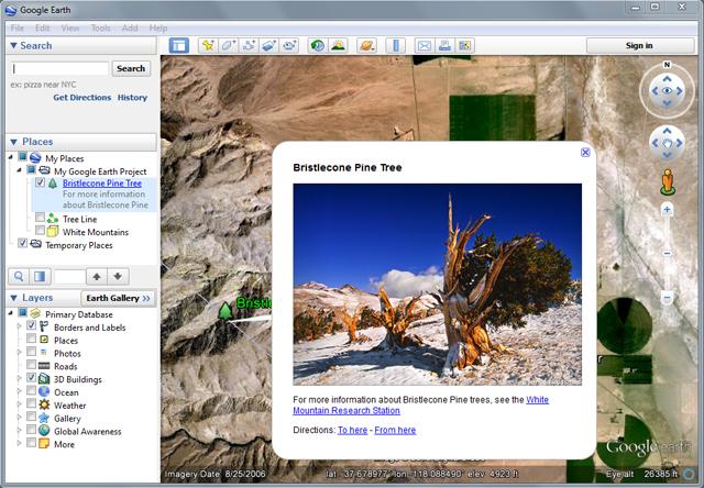
10 Embed Images in your Balloons Google Earth balloons can be customized using HTML. You can add font sizes, styles, and colors, links, tables, and images into your balloons by including it as HTML in the Description. 1 Choose a placemark you've already created, such as the placemark created earlier in this tutorial. 2 To edit the placemark, right- click on the placemark in the 3D viewer or in the Places panel, and choose Get Info (on a Mac). 3 Click on the "Add image..." button, and copy and paste the following image URL (which references an online photo of a bristlecone pine tree) into the Image URL box ( ). Then click OK. 4 You will see the HTML code for the image automatically entered into the Description field. 10
 into the Link URL box (http://www.wmrs.edu/).")

11 5 Select the text "White Mountain Research Station" and click on the "Add link..." button. Copy and paste the following URL (which reference the URL of the research station) into the Link URL box ( Then click OK. 6. You will now see the HTML code for the link automatically entered around the text you highlighted in the Description field. 6 Click OK to finish editing the placemark. 7. Click on the placemark in the 3D viewer, and you will see the image, text, and link in the placemark's balloon! 11
12 12

13 Embed YouTube videos in your Balloons You can easily embed a YouTube video into a placemark balloon in Google Earth. 1 Upload your video to YouTube or choose a video that's already uploaded. 2 On the YouTube video's webpage, find the Share button and click it to see more options. Find the Embed button and click it to see more options. Look for the checklist of options below the html code and select the option for "Use old embed code". Now copy the HTML code. The code looks similar to this: <iframe width="420" height="315" src="// frameborder="0" allowfullscreen></iframe> 13


14 3 Choose a placemark you've already created, such as the placemark created earlier in this tutorial. 4 To edit the placemark, right- click on the placemark in the 3D viewer or in the Places panel, and choose Get Info (on a Mac). 5 In the Description field, paste the YouTube HTML code, which you copied in Step 2. 6 Click OK. 7 Now when you click on the placemark, its balloon has the YouTube video! 14


15 Save your project and share with others Google Earth allows you to save your project to your computer in the.kmz file format. 1 Right- click on your project folder, and select Save Place As... or click on the folder and then go to the File menu, and select Save Place As... 2 Enter a name for your.kmz file, and click Save to save it to your computer. You will now find your KMZ file on your computer. 15
Working with Google Earth
 Working with Google Earth The Places panel in Google Earth serves as a repository to bookmark locations that you want easy access to. There are two folders located in Places: My Places and Temporary Places.
FrontCounter BC Discovery Tool Instructions. NOTE: You must have Google Earth installed to use this tool.
 NOTE: You must have Google Earth installed to use this tool. These instructions are written for use with a Microsoft Windows Work Station. This tutorial will step you through navigating to and viewing
ATNS. USING Google EARTH. Version 1
 ATNS USING Google EARTH Version 1 ATNS/HO/Using Google Earth Page 1 25/04/2013 CONTENTS 1. BASIC SETUP 2. NAVIGATING IN GOOGLE EARTH 3. ADDING OBJECTS TO GOOGLE EARTH 4. USER HELP REFERENCES ATNS/HO/Using
Introduction to Google Earth Tutorial Haiti. 3/15/2011. Tufts GIS Center. Data Exploration
 Introduction to Google Earth Tutorial Haiti. 3/15/2011. Tufts GIS Center. Data Exploration 1. Open Google Earth 2. On the left you will see a navigation pane with 3 sections: Search, Places and Layers.
Create Geomark in Google Earth Tutorial
 Create Geomark in Google Earth Tutorial General business example a potential applicant / user wants to create an area of interest that can be shared electronically to another party eg: another agency,
Partnership for the East Asian-Australasian Flyway. Site Boundaries in Google Earth & Google Maps. Using Google Maps
 Partnership for the East Asian-Australasian Flyway Site Boundaries in Google Earth & Google Maps It is often easy to draw boundaries in order to standardise site coverage and help monitor the correct area
Creating a Facility Boundary Geospatial File Using Google Earth
 Creating a Facility Boundary Geospatial File Using Google Earth This document has been developed in collaboration with Environment and Climate Change Canada Creating a Facility Boundary Map using Google
Google Earth Tutorial 1: The Basics of Map-making in Google Earth 6.2
 Google Earth Tutorial 1: The Basics of Map-making in Google Earth 6.2 University of Waterloo Map Library, 2012 Part 1: Placemarks 1. Locating a Geographical Area a. Open up Google Earth. b. In the Search
ADOBE DREAMWEAVER CS4 BASICS
 ADOBE DREAMWEAVER CS4 BASICS Dreamweaver CS4 2 This tutorial focuses on the basic steps involved in creating an attractive, functional website. In using this tutorial you will learn to design a site layout,
Tutorial for Importing Open Green Map Sites into Google Earth
 Tutorial for Importing Open Green Map Sites into Google Earth Step 1. Download your Open Green Map data files by logging in on Open Green Map and viewing your map(s). Choose the Import/Export tab over
Data Visualization Techniques with Google Earth
 Data Visualization Techniques with Google Earth E-Learning for the GIS Professional Any Time, Any Place! geospatialtraining.com Course Outline Module 1: Google Earth Pro Fundamentals Module 2: Adding Features
Google Sites 101. Mrs. Wilson
 Google Sites 101 Mrs. Wilson Google Sites 101 Create a site 1. Go to http://sites.google.com/ 2. Login with your Google Account [or Google Apps account] email address and password You can create a Google
Completing Baseline s Site Survey Request Form
 Completing Baseline s Site Survey Request Form The first step in successfully implementing a radio network for your irrigation controllers is to identify the proposed locations for each radio. These radios
Using Google Earth Pro
 Using Google Earth Pro (v7.3.2) University of Toronto Mississauga Library Hazel McCallion Academic Learning Centre October 2018 FURTHER ASSISTANCE If you have questions or need assistance contact Tanya
Google Earth: Significant Places in Your Life Got Maps? Workshop June 17, 2013
 Google Earth: Significant Places in Your Life Got Maps? Workshop June 17, 2013 1. Open Google Earth. 2. Familiarize yourself with Google Earth s navigational features by zooming into Furman s campus, your
ADDING VIDEO PAGES. DOCUMENT Here is a guide to adding videos to your responsive website in Webdadi. WEBDADI Updated Jan 2016
 DOCUMENT Here is a guide to adding videos to your responsive website in Webdadi WEBDADI Updated Jan 2016 ADDING VIDEO PAGES How to add a page of videos to your website, or individual videos featured on
Features of the Seafloor Google Earth Tour Project (15 points)
") NAME: DATE: Features of the Seafloor Google Earth Tour Project (15 points) What are the highest and lowest places on Earth? If you named Mt. Everest and the Grand Canyon, you are incorrect! The tallest
NAME: DATE: Features of the Seafloor Google Earth Tour Project (15 points) What are the highest and lowest places on Earth? If you named Mt. Everest and the Grand Canyon, you are incorrect! The tallest
Swiiit User Guide 03/09/2015
 Swiiit User Guide 03/09/2015 Contents Getting Started... 4 Overview of Main Tools... 5 Webpages... 6 Main pages (Sections)... 6 Rearrange Sections... 6 Subpages... 7 Change the Title of a Webpage... 8
Click the buttons in the interactive below to become familiar with the drawing tool's commands.
 Google Documents Inserting Text Boxes and Shapes Introduction Page 1 Google Documents has a drawing tool designed for inserting text boxes and shapes into your document. Although not necessary for every
Advertiser s Guide to using the CMS system for
 Advertiser s Guide to using the CMS system for Revised: 03/12/2015 Accessing Your Account Access your MyBaseGuide advertiser account by going online to: http://cms.mybaseguide.com From the log-on screen
This user guide covers select features of the desktop site. These include:
 User Guide myobservatory Topics Covered: Desktop Site, Select Features Date: January 27, 2014 Overview This user guide covers select features of the desktop site. These include: 1. Data Uploads... 2 1.1
Introduction to Google Earth
 Introduction to Google Earth Assignment: The goal of this assignment is for you to become familiar with Google Earth. You may work alone or with a partner but you must turn in your own individual work.
Google Earth Pro: A tutorial
 Google Earth Pro: A tutorial 1 OVERVIEW As of early 2015, Google Earth Pro, which used to be a $400 product, is now free. This is a powerful yet simple tool for viewing information geographically whether
Google Earth II: Create a tour with Google Earth
 Google Earth II: Create a tour with Google Earth This workshop is a continuation of The Google Earth Workshop I: Map-making Basics. You will create a tour to show the main and satellite campuses of the
MAKING MAPS WITH GOOGLE FUSION TABLES. (Data for this tutorial at
 MAKING MAPS WITH GOOGLE FUSION TABLES (Data for this tutorial at www.peteraldhous.com/data) Thanks to Google Fusion Tables, creating maps from data and embedding them on a web page is now easy. We re going
InSite Prepress Portal Quick Start Guide IPP 9.0
 InSite Prepress Portal Quick Start Guide IPP 9.0 Exported on 07/26/2018 Table of Contents 1 What is InSite Prepress Portal?... 4 1.1 Getting familiar with InSite Prepress Portal 9.0...4 1.2 Use a single
Using Google Earth. Middlebury College Library and Information Services
 Using Google Earth Middlebury College Introduction: While Google Earth can be a fun tool for simply looking at the surface of the earth, there are many other more sophisticated features to explore. Google
Using Adobe Contribute 4 A guide for new website authors
 Using Adobe Contribute 4 A guide for new website authors Adobe Contribute allows you to easily update websites without any knowledge of HTML. This handout will provide an introduction to Adobe Contribute
What s New in Office 2010?
 What s New in Office 2010? General Changes in Office 2010 Applications This document provides a summary of highlighted/significant changes in Office 2010 with simple step-by-step directions for each highlighted
The Text scrap sheet is also needed for copying image and webpage URLs for easy access. Additionally you will use it to look at HTML when needed.
 epro 2 Hints Always have open Word and Text scrap sheets so you can write your text, spell check etc. in Word. You MUST copy and paste your writings onto Text to remove formatting. The Text scrap sheet
How to add video to JigsawBox
 How to add video to JigsawBox Firstly you will need some information: Videos cannot be uploaded directly into JigsawBox as they MUST be hosted on a video storage site like Screencast (which is free) or
Embed a Google File in a Google Site Page
 Embed a Google File in a Google Site Page Rather than simply posting a pdf or video for someone to view, you can easily embed the file so that it is displayed as the web page is opened no waiting around
Beginners Guide to Snippet Master PRO
 Beginners Guide to Snippet Master PRO This document assumes that Snippet Master has been installed on your site. If not please contact the Bakas IT web team at webreg@bakasit.com.au. Initial Login Screen...
Table of Contents. Overview... 4 Advanced Content Items... 4 Accessibility... 4 iframe Textpoppers Math Characters and Equations...
 Dallas County Community College District Table of Contents Overview... 4 Advanced Content Items... 4 Accessibility... 4 iframe... 4 Insert a Web Page... 4 Insert a PDF... 6 Textpoppers... 8 Insert a Text
Figure 1: Syllabus opened in Word Online. Click the File tab (1)
") Embedding Office 365 Files in Blackboard Introduction Today, as part of our faculty professional development, we are going to cover how to embed Microsoft Office files in Blackboard. The purpose of embedding
Embedding Office 365 Files in Blackboard Introduction Today, as part of our faculty professional development, we are going to cover how to embed Microsoft Office files in Blackboard. The purpose of embedding
Our Goals Teaching with Power Point
 Our Goals Teaching with Power Point October 14, 2003 Create a new presentation. Add text, graphics,charts, and tables. Apply transitions. Insert hyperlinks such as: http://www.hamline.edu Goals Continued
About Freeway. Freeway s Tools and Palettes
 About Freeway The most important thing to appreciate before you start a site in Freeway is how the process works, especially if you have tried other Web publishing software before. Freeway is not an HTML
Enterprise Application Systems
 INFORMATION TECHNOLOGY Enterprise Application Systems Mt. San Antonio College Information Technology 1100 North Grand Avenue Building 23 Walnut, CA 91789 Help Desk 909.274.4357 Contents Accessing OmniUpdate
PlaceMap. Accommodation. Slide 1
 PlaceMap for Accommodation Slide 1 PlaceMap Using the power of Google Earth to store and display all of your spatial data in a much more dynamic way Google Earth is a free software program that lets you
With Google documents, you can easily create, share, and edit documents online.
 GOOGLE DOCS With Google documents, you can easily create, share, and edit documents online. Here are a few specific things you can do: Upload Microsoft Word, OpenOffice, RTF, HTML or plain text documents,
Center for Faculty Development and Support Creating Powerful and Accessible Presentation
 Creating Powerful and Accessible Presentation PowerPoint 2007 Windows Tutorial Contents Create a New Document... 3 Navigate in the Normal View (default view)... 3 Input and Manipulate Text in a Slide...
2. The flight across the globe will begin and your final destination will be your home.
 Google Earth 5.0 The Google Earth interface has a toolbar across the top and a panel down the left side. On the left panel, there are three sections: Search, Places and Layers. 1. In the Search section,
Developer s Tip Print to Scale Feature in Slide
 Developer s Tip Print to Scale Feature in Slide The latest update to Slide 5.0 brings a number of improvements related to printing functionality, giving the user greater control over printed output. Users
Nauticom NetEditor: A How-to Guide
 Nauticom NetEditor: A How-to Guide Table of Contents 1. Getting Started 2. The Editor Full Screen Preview Search Check Spelling Clipboard: Cut, Copy, and Paste Undo / Redo Foreground Color Background Color
Blogger Frequently Asked Questions
 Blogger Frequently Asked Questions Blogger is an easy to use blogging tool, allowing you to contribute to existing blogs and create your own. Blogger requires a Google account to register. This guide will
NVU Web Authoring System
 NVU Web Authoring System http://www.nvu.com/index.php Table of Contents Using Nvu as Your Web Page Authoring System: Getting Started Opening a page, saving, and previewing your work...3 Formatting the
Mapper version 1.0 User's Manual
 Mapper version 1.0 User's Manual Contents 1 Introduction... 3 2 User Interface... 4 2.1 Main screen...4 2.1.1 Toolbar... 6 2.1.2 Image properties panel... 7 2.2 Project window... 10 2.3 Map window... 13
FrontPage 2000 Tutorial -- Advanced
 FrontPage 2000 Tutorial -- Advanced Shared Borders Shared Borders are parts of the web page that share content with the other pages in the web. They are located at the top, bottom, left side, or right
PROFILE DESIGN TUTORIAL KIT
 PROFILE DESIGN TUTORIAL KIT NEW PROFILE With the help of feedback from our users and designers worldwide, we ve given our profiles a new look and feel. The new profile is designed to enhance yet simplify
NETZONE CMS User Guide Copyright Tomahawk
 NETZONE CMS User Guide Copyright 2015. Tomahawk 1 Phone: + 64 9 522 2333 Email: getintouch@tomahawk.co.nz Tomahawk 2015 www.tomahawk.co.nz 2 NETZONE CMS USER GUIDE WHAT YOU LL FIND INSIDE LOGGING IN 4
Dreamweaver Basics Outline
 Dreamweaver Basics Outline The Interface Toolbar Status Bar Property Inspector Insert Toolbar Right Palette Modify Page Properties File Structure Define Site Building Our Webpage Working with Tables Working
Note: This tutorial was designed for Windows users. Applications DANA PORTER LIBRARY. February 19, 2013 Authored by: The Geospatial Centre
 Applications DANA PORTER LIBRARY February 19, 2013 Authored by: The Geospatial Centre 0 TABLE OF CONTENTS Google Earth Introduction... 2 Historical Imagery... 3 Objective... 3 Step by Step... 3 Ruler...
Creating a Website in Schoolwires
 Creating a Website in Schoolwires Overview and Terminology... 2 Logging into Schoolwires... 2 Changing a password... 2 Navigating to an assigned section... 2 Accessing Site Manager... 2 Section Workspace
Recipes4Success. Create a Storybook. ImageBlender 2.5 Storybook Maker
 In this Recipe you will use the ImageBlender Storybook Maker to create a storybook from a folder of images. You will learn how to add a folder of images, change the order of pages in the storybook, add
Formatting the Question Text and Adding Images, Media Objects, Tables etc.
 Formatting the Question Text and Adding Images, Media Objects, Tables etc. Formatting the Text (Bold, Italics, Underline, and Super/Subscript) Highlight the text you want to modify and click the appropriate
Using the Seven Horizons Wiki
 Using the Seven Horizons Wiki Index Using the Seven Horizons Wiki... 1 Searching for a Technology:... 1 To Edit an Existing Page:... 2 To Create a New Page... 3 To Add a Photo or Image... 5 Add a Video...
Picasa for Mac Users. 1. Go to Click Download Picasa for Mac (Beta) to download Picasa. 2. You will see this screen:
 to download Picasa. 2. You will see this screen:") Picasa for Mac Users 1. Go to http://picasa.google.com/mac/. Click Download Picasa for Mac (Beta) to download Picasa. 2. You will see this screen: 3. You will see that Picasa has been downloaded in Downloads
Picasa for Mac Users 1. Go to http://picasa.google.com/mac/. Click Download Picasa for Mac (Beta) to download Picasa. 2. You will see this screen: 3. You will see that Picasa has been downloaded in Downloads
Brought to You By: University of Connecticut Center for Land Use Education and Research (CLEAR) University of Rhode Island Coastal Institute USDA
 University of Rhode Island Coastal Institute USDA") Mashup Madness: Using Google to Display Geographic Information on the Web February 22, 2010 Land & Sea Grant National Water Conference Hilton Head, SC Brought to You By: University of Connecticut Center
Mashup Madness: Using Google to Display Geographic Information on the Web February 22, 2010 Land & Sea Grant National Water Conference Hilton Head, SC Brought to You By: University of Connecticut Center
Study before beginning these instructions.
 NOTE: You will be switching back and forth between two sites. 1. Education.Weebly.com where you edit and create 2. Your site which is what the public will see (i.e., eesl521.weebly.com) Study http://eesl521.weebly.com
Adobe Dreamweaver CC 17 Tutorial
 Adobe Dreamweaver CC 17 Tutorial GETTING STARTED This tutorial focuses on the basic steps involved in creating an attractive, functional website. In using this tutorial you will learn to design a site
Users who require access to this application must seek it from their Security Administrator.
 WEB EDITOR SUBARU CONNECT Web Editor is now available on Subaru Connect, located under Applications > Website Maintenance > Webpage Editor. This completely redesigned version of the Web Editor enables
The Preparing for Success Online Mapping Tool
 The Preparing for Success Online Mapping Tool Baker Polito Administration The Executive Office of Housing and Economic Development and MassGIS Questions & Comments? Please contact MassWorks@state.ma.us
This Tutorial is for Word 2007 but 2003 instructions are included in [brackets] after of each step.
![This Tutorial is for Word 2007 but 2003 instructions are included in [brackets] after of each step.](/thumbs/89/98497436.jpg "This Tutorial is for Word 2007 but 2003 instructions are included in [brackets] after of each step.") This Tutorial is for Word 2007 but 2003 instructions are included in [brackets] after of each step. Table of Contents Get Organized... 1 Create the Home Page... 1 Save the Home Page as a Word Document...
This Tutorial is for Word 2007 but 2003 instructions are included in [brackets] after of each step. Table of Contents Get Organized... 1 Create the Home Page... 1 Save the Home Page as a Word Document...
PowerPoint Tips and Tricks
 PowerPoint Tips and Tricks Viewing Your Presentation PowerPoint provides multiple ways to view your slide show presentation. You can access these options either through a toolbar on your screen or by pulling
ESD Website Tutorial 1: Basic Editing. Please login to our NEW website:
 ESD Website Tutorial 1: Basic Editing Please login to our NEW website: www.estacada.k12.or.us 1 Finding Your Login: 1) Go to your school website and log in at the top of the page 2) Log in with the same
This Tutorial is for Word 2007 but 2003 instructions are included in [brackets] after of each step.
![This Tutorial is for Word 2007 but 2003 instructions are included in [brackets] after of each step.](/thumbs/72/67280806.jpg "This Tutorial is for Word 2007 but 2003 instructions are included in [brackets] after of each step.") This Tutorial is for Word 2007 but 2003 instructions are included in [brackets] after of each step. Table of Contents Just so you know: Things You Can t Do with Word... 1 Get Organized... 1 Create the
This Tutorial is for Word 2007 but 2003 instructions are included in [brackets] after of each step. Table of Contents Just so you know: Things You Can t Do with Word... 1 Get Organized... 1 Create the
Major features Support multi-language Automatically match photo and GPS tracks by time synchronization. Add photo comments.
 Users Manual V1.1 Users Manual Major features Read GPS log from device Add Photo and photo management Auto match photo and waypoints in tracks Shift photo time View in Google earth Save as kmz file GeoTag
HOW TO USE THE CONTENT MANAGEMENT SYSTEM (CMS) TABLE OF CONTENTS
 TABLE OF CONTENTS") HOW TO USE THE CONTENT MANAGEMENT SYSTEM (CMS) TABLE OF CONTENTS GETTING STARTED (LOGIN) 2 SITE MAP (ORGANIZE WEBPAGES) 2 CREATE NEW PAGE 3 REMOVE PAGE 6 SORT PAGES IN CHANNEL 7 MOVE PAGE 8 PAGE PROPERTIES
HOW TO USE THE CONTENT MANAGEMENT SYSTEM (CMS) TABLE OF CONTENTS GETTING STARTED (LOGIN) 2 SITE MAP (ORGANIZE WEBPAGES) 2 CREATE NEW PAGE 3 REMOVE PAGE 6 SORT PAGES IN CHANNEL 7 MOVE PAGE 8 PAGE PROPERTIES
Shape Cluster Photo Written by Steve Patterson
 Shape Cluster Photo Written by Steve Patterson Before After Step 1: Create A New Document Let's begin by creating a new Photoshop document. Go up to the File menu in the Menu Bar along the top of the screen
How to Edit Your Website
 How to Edit Your Website A guide to using your Content Management System Overview 2 Accessing the CMS 2 Choosing Your Language 2 Resetting Your Password 3 Sites 4 Favorites 4 Pages 5 Creating Pages 5 Managing
Adobe Dreamweaver CS5 Tutorial
 Adobe Dreamweaver CS5 Tutorial GETTING STARTED This tutorial focuses on the basic steps involved in creating an attractive, functional website. In using this tutorial you will learn to design a site layout,
Google Earth for Genealogy October 15, 2016 Heritage Hunters of Saratoga County
 Google Earth for Genealogy October 15, 2016 Heritage Hunters of Saratoga County http://www.saratoganygenweb.com/gwsarhh.html Dennis A. Hogan, http:// This Complete Presentation is available online At,
Obtaining Aerial Images from Google Earth
 Obtaining Aerial Images from Google Earth Introduction This tutorial will demonstrate how to use the Google Earth application to obtain a site-wide aerial photograph for a modeling project. The tutorial
What is MapBuddy: The main toolbar: MapBuddy Reference Guide V1.0
 MapBuddy Reference Guide V1.0 What is MapBuddy: MapBuddy is a Windows application designed for searching, storing and displaying information on top of a Google Maps interface. MapBuddy has various optional
You ll also be able to add markers like Placemarks to keep track of some special locations.
 Google Earth Basics Google helps bring the world to your desktop with Google Earth. This program allows you to search for specific locations and then zooms in to bring those areas to life through aerial
Creating a Simple Webpage using Microsoft FrontPage 2003
 Creating a Simple Webpage using Microsoft FrontPage 2003 Professor Carrie Damschroder ENGL 317: Technical Communication October 27, 2009 Brandi Goodman Heather Stanfield Dylan Thompson Nikki Truong Page
Website Creating Content
 CREATING WEBSITE CONTENT As an administrator, you will need to know how to create content pages within your website. This document will help you learn how to: Create Custom Pages Edit Content Areas Creating
HOW TO ADD A COMMERCIAL LISTING FOR SALE WITH MEDIA
 HOW TO ADD A COMMERCIAL LISTING FOR SALE WITH MEDIA OVERVIEW: Adding and updating listings are performed in the LISTING section of CREST EDG. Not only will you be able to add / update your listing but
In this tutorial, you will learn how to perform basic tasks for setting up a course site in Moodle.
 Curriculum and Instructional Materials Center 1-800-654-4502 www.okcimc.com 1: INTRO TO MOODLE WELCOME TO THE INTRO TO MOODLE TRAINING ACTIVITY! In this tutorial, you will learn how to perform basic tasks
How to Use Moodle's Text Editor
 How to Use Moodle's Text Editor The text editor has a variety of tools and icons to assist in formatting text, adding links, and inserting images. Many of them will be familiar to anyone who uses word
Getting Started with Wrap
 Getting Started with Wrap This Getting Started guide will show you how to build your first Wrap and highlight some of the major features in the Wrap authoring platform. You will learn how to: Create a
TUTORIAL TO CREATE AOI POLYGONS IN GOOGLE EARTH PRO
 TUTORIAL TO CREATE AOI POLYGONS IN GOOGLE EARTH PRO 1: You will need GoogleEarth Pro (freeware) to generate your Area of Interest (AOI). You can get a copy of GoogleEarth Pro from the link provided below.
An Introduction to Google Earth Pro
 An Introduction to Google Earth Pro Virginia Tech Geospatial Extension Program By: Katherine Britt Ph.D. Candidate Virginia Tech Department of Forest Resources and Environmental Conservation John McGee
Swiiit User Guide 09/11/2016
 Swiiit User Guide 09/11/2016 Contents Getting Started... 4 Overview of Main Tools... 5 Webpages... 6 Main pages (Sections)... 6 Rearrange Sections... 6 Subpages... 7 Change the Title of a Webpage... 8
In order to follow this set of directions you will need the following
 How to Create Maps & Figures in ArcView 9x In order to follow this set of directions you will need the following 1) the Jenny s Louisiana GIS Instructional CD 2) a computer with ArcGIS on it (version 9.0
Articulate Engage 2013 Tutorial
 How to Access Engage 1. By Launching Engage Directly o You can open Engage directly from the desktop by clicking on the green Engage Icon, which is shown in the top right corner of this manual. 2. By Launching
Severe Weather Safety PSA
 Contents Add Text 2 Format Text 3 Add Stickers 4 Resize Stickers 8 Change the Color of the Canvas 9 Name the Project 12 Add a Page 12 Practice Adding and Formatting Text 13 Use the Paint Brush Tool 14
How to Use Google Earth for GPS Coordinates & Maps
 Kentucky Department of Agriculture Industrial Hemp Research Pilot Program How to Use Google Earth for GPS Coordinates & Maps 2018 Google Earth Preferred GPS Coordinates - Google Earth Pro is the preferred
Mouse. Mouse Action Location. Image Location
 Mouse The Mouse action group is intended for interacting with user interface using mouse (move, click, drag, scroll). All the Mouse actions are automatically recorded when you manipulate your mouse during
Adobe Dreamweaver CC Tutorial
 Adobe Dreamweaver CC Tutorial The design of the Web site index.html Click main.html header Boys toys Girls toys Media Contact us content Links sidebar1 footer content1.html content2.html content3.html
How to digitize site (counting unit) boundaries
 boundaries") How to digitize site (counting unit) boundaries Drawing site boundaries is an easy way to standardise site coverage and help counters monitor the correct area and route. Digitising site boundaries allows
How to digitize site (counting unit) boundaries Drawing site boundaries is an easy way to standardise site coverage and help counters monitor the correct area and route. Digitising site boundaries allows
RAPIDMAP Geocortex HTML5 Viewer Manual
 RAPIDMAP Geocortex HTML5 Viewer Manual This site was developed using the evolving HTML5 web standard and should work in most modern browsers including IE, Safari, Chrome and Firefox. Even though it was
BHM Website Teacher User Guide
 BHM Website Teacher User Guide How to Login 1. Go to HUhttp://bhmschools.org/userUH 2. Enter your username and password and click Log in How to Change Your Password 1. Go to My Account in your Nav bar
Dreamweaver Basics. Planning your website Organize site structure Plan site design & navigation Gather your assets
 Dreamweaver Basics Planning your website Organize site structure Plan site design & navigation Gather your assets Creating your website Dreamweaver workspace Define a site Create a web page Linking Manually
FrontPage. Directions & Reference
 FrontPage Directions & Reference August 2006 Table of Contents Page No. Open, Create, Save WebPages Open Webpage... 1 Create and Save a New Page... 1-2 Change the Background Color of Your Web Page...
IMAGE LINKS - INTRODUCTION
 IMAGE LINKS - EMAIL INTRODUCTION The purpose of this document is to provide guidance for client website administrators who create and maintain content on how to create image links to content. RELATED IMAGE
How to...create a Video VBOX Gauge in Inkscape. So you want to create your own gauge? How about a transparent background for those text elements?
 BASIC GAUGE CREATION The Video VBox setup software is capable of using many different image formats for gauge backgrounds, static images, or logos, including Bitmaps, JPEGs, or PNG s. When the software
Microsoft FrontPage Practical Session
 Ministry of manpower Higher college of technology Department of Information Technology QA Umbrella Workshop 30 th August- 3 rd September 2008 IT Skills Microsoft FrontPage Practical Session Copyright of
Waushara County Public Access Land Records Viewer Help
 Waushara County Public Access Land Records Viewer Help Main Screen Layout Overview Zoom Pan Controls Parcel Tools Tools Help and Links Image Layers Transition Tools Search Results from Parcel Search Tool
USER GUIDE: EDITOR. Drag & drop system: Content Manager Style Editor Add Elements Undo/Redo Save...
 USER GUIDE: EDITOR Drag & drop system:... 2 1. Content Manager... 3 2. Style Editor... 5 3. Add Elements... 6 4. Undo/Redo... 13 5. Save... 13 When we access Zeendo s website editor, we can see a series