Working with Elevation Data URPL 969 Applied GIS Workshop: Rethinking New Orleans After Hurricane Katrina Spring 2006
|
|
|
- Rebecca Hodges
- 5 years ago
- Views:
Transcription

1 Working with Elevation Data URPL 969 Applied GIS Workshop: Rethinking New Orleans After Hurricane Katrina Spring 2006 This GIS lab exercise will explore Light Detection And Ranging (LiDAR) data for New Orleans collected as part of a statewide project in Louisiana. The exercise was prepared using ArcGIS 9.0. Step 1. Download and Extract LIDAR Data Use an Internet Browser to access the Louisiana State University Atlas website at Click on the Download Data button and then scroll down and select LIDAR Data. This site can be accessed directly at

.")
2 Begin the selection process for the LIDAR data by using the dropdown menus to complete the phrase -- 1) Select ¼ quad attribute USGS Name starting with New Orleans East. Click Submit. On the left side of the page click on the gray Download button to the right of DEM to download the New Orleans East NE LIDAR Digital Elevation Model (2.70 MB zip file). When prompted with the File Download dialog box, click Save, navigate to an appropriate location and create a folder titled no-lidar in which to save the file. Use the same process to download the DEM for New Orleans East NW (3.18 MB zip file).


3 Use WinZip to extract the compressed files in the.zip files. Step 2. Convert the LIDAR Files into the GRID Format Open ArcCatalog. You can use the icon on the desktop, if available. If not, click on the Start button in the lower left corner of the screen and under programs, choose ArcGIS and then ArcCatalog. Open ArcTools by clicking on the Red Toolbox icon. The LIDAR files are in a USGS DEM format. In the ArcToolbox menu, select Conversion Tools, then To Raster, and finally DEM to Raster.

4 In the DEM to Raster dialog box, make the following choices: Input USGS DEM file: dem_ ne.dem Output raster: no-east-ne Output data type: Integer Click OK and close the window when complete. Repeat the process for the New Orleans East NW file with the following choices Input USGS DEM file: dem_ nw.dem Output raster: no-east-nw Output data type: Integer You now have two LIDAR quarter quads in Arc GRID format.

5 Step 3. Merge the LIDAR Files In the ArcToolbox menu, select Data Management Tools, then Raster, and finally Mosaic to New Raster In the Mosaic to New Raster dialog box, select both the no-east-ne and no-east-nw GRID files as Input Rasters: Choose the no-lidar folder as the Output Location and type no-east-merged as the Raster dataset name with extension.

6 Click OK. When the process is complete, close the dialog box In ArcCatalog, on the Contents window on the left side of the screen, navigate to the nolidar folder and right-click on the no-east-merged GRID file and click on Properties to activate Raster Dataset Properties. View properties for Dataset, Raster, Extent, Spatial Reference, and Statistics.
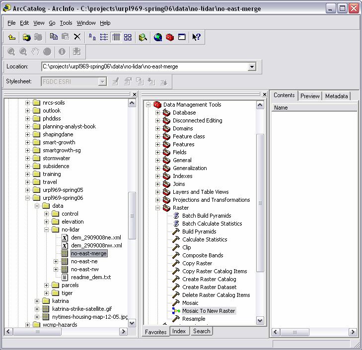
7


8 Step 4. View Merged LIDAR Data Open ArcMap. Add Data. [no-east-merge] Explore Effects Tools. View >>> Toolbars >>> Effects Transparency, brightness, contrast Right Click on no-east-merge theme in table of contents, select Properties Layer Properties dialog box Display tab (Show Map Tips, Display raster resolution in table of contents)
9 Symbology tab Unique Values (random)


10 Unique values Apply color scheme Click lowest elevation value. Hold shift key and click highest elevation value. On color scheme drop-down, scroll down near bottom and select appropriate color scheme. Click apply. Unique values Separate above sea level and below sea level Click color box for lowest elevation value (-28) shift key and click box for (-1) and then double click to invoke color pallette. Select a light green. Click color box for (1) and then hold shift key for (46) and then double click to invoke color pallette. Select a light red. Click apply. Note extent of area below sea level.


11 Classified Choose 10 classes. Choose appropriate color ramp. Click on Classify button to see histogram and adjust values. Set breaks in groups of five. Click OK. Click Apply.


12 Stretched Click color ramp. Make appropriate selection. Explore stretch type. Explore Histogram button. Step 5. Explore Spatial Analyst Extension Invoke Spatial Analyst Extension Tools >>> Extensions. Make sure Spatial Analyst is available and checked. Also select 3D Analyst.

13 View >>> Toolbars. Make sure Spatial Analyst is selected. Create Contour Tool Zoom in on Fairgrounds Select Create Contour Tool and click on edge of pond in fairgrounds. Zoom to extent. Select Create Contour Tool and click on Mississippi River levee. Experiment with tool. Use Select elements tool in Tools toolbar to select and delete contour graphics.


14 Hillshade Zoom to extent Spatial Analyst drop-down menu >>> Surface Analysis >>> Hillshade Accept defaults in Hillshade dialog box and click OK. Repeat with Z-factor of 0.3. Repeat with Z-factor of 3.2. Experiment.


15 Contours Spatial Analyst drop-down menu >>> Surface Analysis >>> Contours Choose Contour Interval of 2. Click OK. [MAY BE TIME CONSUMING] Use Layer Properties to symbolize contours.

16 Step 6. Explore 3D Analyst Extension View >>> Toolbars. Make sure 3D Analyst is selected. Start ArcScene Add no-east-nw grid Right click theme to invoke Layer Properties Click Base Heights tab Click Obtain heights for layer from surface. Click OK [MAY TAKE AWHILE] Set Z Unit conversion to 15. Use Symbology tab to apply a color ramp. Click OK. In ArcScene, use left mouse click to tilt perspective. Use right mouse click to zoom in and out.


17 Explore Line of Sight tool Explore Create Profile Graph tool Extra Credit: Use MyWebSpace and class group directory to download citywide merged LiDAR data. Extract and explore. To be added later. Explore Hydrologic Modeling Extension. Will need to be installed from Developer s Kit Created by David Hart, University of Wisconsin Sea Grant Institute February 10, 2006
Introduction to GIS 2011
 Introduction to GIS 2011 Digital Elevation Models CREATING A TIN SURFACE FROM CONTOUR LINES 1. Start ArcCatalog from either Desktop or Start Menu. 2. In ArcCatalog, create a new folder dem under your c:\introgis_2011
A Second Look at DEM s
 A Second Look at DEM s Overview Detailed topographic data is available for the U.S. from several sources and in several formats. Perhaps the most readily available and easy to use is the National Elevation
Basics of Using LiDAR Data
 Conservation Applications of LiDAR Basics of Using LiDAR Data Exercise #2: Raster Processing 2013 Joel Nelson, University of Minnesota Department of Soil, Water, and Climate This exercise was developed
Lab 18c: Spatial Analysis III: Clip a raster file using a Polygon Shapefile
 Environmental GIS Prepared by Dr. Zhi Wang, CSUF EES Department Lab 18c: Spatial Analysis III: Clip a raster file using a Polygon Shapefile These instructions enable you to clip a raster layer in ArcMap
Creating Contours using ArcMap
 Creating Contours with ArcMap and ArcScene Digital elevation models (DEMs) are geospatial datasets that contain elevation values sampled according to a regularly spaced rectangular grid. They can be used
START>PROGRAMS>ARCGIS>
 Department of Urban Studies and Planning Spring 2006 Department of Architecture Site and Urban Systems Planning 11.304J / 4.255J GIS EXERCISE 2 Objectives: To generate the following maps using ArcGIS Software:
GIS LAB 8. Raster Data Applications Watershed Delineation
 GIS LAB 8 Raster Data Applications Watershed Delineation This lab will require you to further your familiarity with raster data structures and the Spatial Analyst. The data for this lab are drawn from
Geographical Information Systems Institute. Center for Geographic Analysis, Harvard University. LAB EXERCISE 1: Basic Mapping in ArcMap
 Harvard University Introduction to ArcMap Geographical Information Systems Institute Center for Geographic Analysis, Harvard University LAB EXERCISE 1: Basic Mapping in ArcMap Individual files (lab instructions,
GEO 465/565 Lab 6: Modeling Landslide Susceptibility
 1 GEO 465/565 Lab 6: Modeling Landslide Susceptibility This lab will give you more practice in understanding and building a GIS analysis model. Recall from class lecture that a GIS analysis model is a
Opening Canadian Digital Elevation Data Files in ArcMap 9.x
 Opening Canadian Digital Elevation Data Files in ArcMap 9.x These procedures outline: 1. Downloading spatial data from the GeoBase website (accessed through the Ryerson University Library website) 2. Uncompressing
GEO 465/565 - Lab 7 Working with GTOPO30 Data in ArcGIS 9
 GEO 465/565 - Lab 7 Working with GTOPO30 Data in ArcGIS 9 This lab explains how work with a Global 30-Arc-Second (GTOPO30) digital elevation model (DEM) from the U.S. Geological Survey. This dataset can
Finding and Using Spatial Data
 Finding and Using Spatial Data Introduction In this lab, you will download two different versions of the National Wetlands Inventory (NWI) dataset for a region of Massachusetts, from a source on the internet.
Using GIS to Site Minimal Excavation Helicopter Landings
 Using GIS to Site Minimal Excavation Helicopter Landings The objective of this analysis is to develop a suitability map for aid in locating helicopter landings in mountainous terrain. The tutorial uses
Lesson 8 : How to Create a Distance from a Water Layer
 Created By: Lane Carter Advisor: Paul Evangelista Date: July 2011 Software: ArcGIS 10 Lesson 8 : How to Create a Distance from a Water Layer Background This tutorial will cover the basic processes involved
Lab 1: Landuse and Hydrology, learning ArcGIS
 Lab 1: Landuse and Hydrology, learning ArcGIS The following lab exercises are designed to give you experience using ArcMap in order to visualize and analyze datasets that are relevant to important geomorphological/
Delineating Watersheds from a Digital Elevation Model (DEM)
") Delineating Watersheds from a Digital Elevation Model (DEM) (Using example from the ESRI virtual campus found at http://training.esri.com/courses/natres/index.cfm?c=153) Download locations for additional
Delineating Watersheds from a Digital Elevation Model (DEM) (Using example from the ESRI virtual campus found at http://training.esri.com/courses/natres/index.cfm?c=153) Download locations for additional
George Mason University Department of Civil, Environmental and Infrastructure Engineering
 George Mason University Department of Civil, Environmental and Infrastructure Engineering Dr. Celso Ferreira Prepared by Lora Baumgartner December 2015 Revised by Brian Ross July 2016 Exercise Topic: GIS
Tutorial 18: 3D and Spatial Analyst - Creating a TIN and Visual Analysis
 Tutorial 18: 3D and Spatial Analyst - Creating a TIN and Visual Analysis Module content 18.1. Creating a TIN 18.2. Spatial Analyst Viewsheds, Slopes, Hillshades and Density. 18.1 Creating a TIN Sometimes
GeoEarthScope NoCAL San Andreas System LiDAR pre computed DEM tutorial
 GeoEarthScope NoCAL San Andreas System LiDAR pre computed DEM tutorial J Ramón Arrowsmith Chris Crosby School of Earth and Space Exploration Arizona State University ramon.arrowsmith@asu.edu http://lidar.asu.edu
Field-Scale Watershed Analysis
 Conservation Applications of LiDAR Field-Scale Watershed Analysis A Supplemental Exercise for the Hydrologic Applications Module Andy Jenks, University of Minnesota Department of Forest Resources 2013
I CALCULATIONS WITHIN AN ATTRIBUTE TABLE
 Geology & Geophysics REU GPS/GIS 1-day workshop handout #4: Working with data in ArcGIS You will create a raster DEM by interpolating contour data, create a shaded relief image, and pull data out of the
GY461 GIS 1: Environmental Campus Topography Project with ArcGIS 9.x
 I. Introduction GY461 GIS 1: Environmental In this project you will use data from a topographic survey of the USA campus to generate 2 separate maps: 1. A color-coded 2-dimensional topographic contour
COPYRIGHTED MATERIAL. Introduction to 3D Data: Modeling with ArcGIS 3D Analyst and Google Earth CHAPTER 1
 CHAPTER 1 Introduction to 3D Data: Modeling with ArcGIS 3D Analyst and Google Earth Introduction to 3D Data is a self - study tutorial workbook that teaches you how to create data and maps with ESRI s
Mapping the Thickness of the Rocky Flats Alluvium and Reconstructing the Pleistocene Rocky Flats Paleogeography (with Spatial Analyst).
.") Exercise 8 Mapping the Thickness of the Rocky Flats Alluvium and Reconstructing the Pleistocene Rocky Flats Paleogeography (with Spatial Analyst). Due: Thursday, February 15, 2018 Goal: Creating Rasters
Exercise 8 Mapping the Thickness of the Rocky Flats Alluvium and Reconstructing the Pleistocene Rocky Flats Paleogeography (with Spatial Analyst). Due: Thursday, February 15, 2018 Goal: Creating Rasters
STUDENT PAGES GIS Tutorial Treasure in the Treasure State
 STUDENT PAGES GIS Tutorial Treasure in the Treasure State Copyright 2015 Bear Trust International GIS Tutorial 1 Exercise 1: Make a Hand Drawn Map of the School Yard and Playground Your teacher will provide
Raster: The Other GIS Data
 Raster_The_Other_GIS_Data.Docx Page 1 of 11 Raster: The Other GIS Data Objectives Understand the raster format and how it is used to model continuous geographic phenomena. Understand how projections &
Converting AutoCAD Map 2002 Projects to ArcGIS
 Introduction This document outlines the procedures necessary for converting an AutoCAD Map drawing containing topologies to ArcGIS version 9.x and higher. This includes the export of polygon and network
Lab 11: Terrain Analyses
 Lab 11: Terrain Analyses What You ll Learn: Basic terrain analysis functions, including watershed, viewshed, and profile processing. There is a mix of old and new functions used in this lab. We ll explain
CRC Website and Online Book Materials Page 1 of 16
 Page 1 of 16 Appendix 2.3 Terrain Analysis with USGS DEMs OBJECTIVES The objectives of this exercise are to teach readers to: Calculate terrain attributes and create hillshade maps and contour maps. use,
INTRODUCTION TO GIS WORKSHOP EXERCISE
 111 Mulford Hall, College of Natural Resources, UC Berkeley (510) 643-4539 INTRODUCTION TO GIS WORKSHOP EXERCISE This exercise is a survey of some GIS and spatial analysis tools for ecological and natural
Lab 1: Introduction to ArcGIS
 Lab 1: Introduction to ArcGIS Objectives In this lab you will: 1) Learn the basics of the software package we will be using for the remainder of the semester, and 2) Discover the role that climate and
Tutorial 1 Exploring ArcGIS
 Tutorial 1 Exploring ArcGIS Before beginning this tutorial, you should make sure your GIS network folder is mapped on the computer you are using. Please refer to the How to map your GIS server folder as
1. Use the Add Data button to add each of the datasets you wish to convert to the map document.
 Projecting your data In order for many GIS functions to work properly, your datasets need to be stored in a common projected coordinate system. This guide will assist you with the projection process in
LAB 1: Introduction to ArcGIS 8
 LAB 1: Introduction to ArcGIS 8 Outline Introduction Purpose Lab Basics o About the Computers o About the software o Additional information Data ArcGIS Applications o Starting ArcGIS o o o Conclusion To
Importing CDED (Canadian Digital Elevation Data) into ArcGIS 9.x
 into ArcGIS 9.x") Importing CDED (Canadian Digital Elevation Data) into ArcGIS 9.x Related Guides: Obtaining Canadian Digital Elevation Data (CDED) Importing Canadian Digital Elevation Data (CDED) into ArcView 3.x Requirements:
Importing CDED (Canadian Digital Elevation Data) into ArcGIS 9.x Related Guides: Obtaining Canadian Digital Elevation Data (CDED) Importing Canadian Digital Elevation Data (CDED) into ArcView 3.x Requirements:
GEOGRAPHIC INFORMATION SYSTEMS Lecture 25: 3D Analyst
 GEOGRAPHIC INFORMATION SYSTEMS Lecture 25: 3D Analyst 3D Analyst - 3D Analyst is an ArcGIS extension designed to work with TIN data (triangulated irregular network) - many of the tools in 3D Analyst also
Terrain Modeling with ArcView GIS from ArcUser magazine
 Lesson 6: DEM-Based Terrain Modeling Lesson Goal: Lean how to output a grid theme that can be used to generate a thematic two-dimensional map, compute an attractive hillshaded map, and create a contour
Tutorial 1: Downloading elevation data
 Tutorial 1: Downloading elevation data Objectives In this exercise you will learn how to acquire elevation data from the website OpenTopography.org, project the dataset into a UTM coordinate system, and
Spatial Analysis with Raster Datasets
 Spatial Analysis with Raster Datasets Francisco Olivera, Ph.D., P.E. Srikanth Koka Lauren Walker Aishwarya Vijaykumar Keri Clary Department of Civil Engineering April 21, 2014 Contents Brief Overview of
Server Usage & Third-Party Viewers
 Server Usage & Third-Party Viewers October 2016 HiPER LOOK Version 1.4.16.0 Copyright 2015 PIXIA Corp. All Rights Reserved. Table of Contents HiPER LOOK Server Introduction... 2 Google Earth... 2 Installation...2
Lecture 22 - Chapter 8 (Raster Analysis, part 3)
") GEOL 452/552 - GIS for Geoscientists I Lecture 22 - Chapter 8 (Raster Analysis, part 3) Today: Zonal Analysis (statistics) for polygons, lines, points, interpolation (IDW), Effects Toolbar, analysis masks
GEOL 452/552 - GIS for Geoscientists I Lecture 22 - Chapter 8 (Raster Analysis, part 3) Today: Zonal Analysis (statistics) for polygons, lines, points, interpolation (IDW), Effects Toolbar, analysis masks
Answer the following general questions: 1. What happens when you right click on an icon on your desktop? When you left double click on an icon?
 Name: Date: June 27th, 2011 GIS Boot Camps For Educators Practical: Explore ArcGIS 10 Desktop Tools and functionality Day_1 Lecture 1 Sources: o ArcGIS Desktop help o ESRI website o Getting to Know ArcGIS
Lab 1: Exploring ArcMap and ArcCatalog In this lab, you will explore the ArcGIS applications ArcCatalog and ArcMap. You will learn how to use
 Lab 1: Exploring ArcMap and ArcCatalog In this lab, you will explore the ArcGIS applications ArcCatalog and ArcMap. You will learn how to use ArcCatalog to find maps and data and how to display maps in
Workshop #12 Using ModelBuilder and Customizing the ArcMap Interface
 Workshop #12 Using ModelBuilder and Customizing the ArcMap Interface Toolboxes can be created in ArcToolbox, in folders or within geodatabases. In this tutorial you will place the toolbox in your project
Workshop Exercises for Digital Terrain Analysis with LiDAR for Clean Water Implementation
 Workshop Exercises for Digital Terrain Analysis with LiDAR for Clean Water Implementation This manual is designed to accompany lecture and handout materials provided at a series of workshops offered in
The ArcMap Interface and Using Basic ArcMap Analysis Tools to Create a Map
 The ArcMap Interface and Using Basic ArcMap Analysis Tools to Create a Map *You will need a computer with ESRI ArcGIS Desktop version 9.3 or higher installed* Data Download 1. Save the zipped folder with
RASTER ANALYSIS S H A W N L. P E N M A N E A R T H D A T A A N A LY S I S C E N T E R U N I V E R S I T Y O F N E W M E X I C O
 RASTER ANALYSIS S H A W N L. P E N M A N E A R T H D A T A A N A LY S I S C E N T E R U N I V E R S I T Y O F N E W M E X I C O TOPICS COVERED Spatial Analyst basics Raster / Vector conversion Raster data
LAB #7 Creating TIN and 3D scenes (ArcScene) GISC, UNIVERSITY OF CALIFORNIA BERKELEY
 GISC, UNIVERSITY OF CALIFORNIA BERKELEY") LAB #7 Creating TIN and 3D scenes (ArcScene) GISC, UNIVERSITY OF CALIFORNIA BERKELEY The purpose of this laboratory is to introduce and explore surface data analysis using a vector data model: TIN. We
LAB #7 Creating TIN and 3D scenes (ArcScene) GISC, UNIVERSITY OF CALIFORNIA BERKELEY The purpose of this laboratory is to introduce and explore surface data analysis using a vector data model: TIN. We
THE HONG KONG POLYTECHNIC UNIVERSITY DEPARTMENT OF LAND SURVEYING & GEO-INFORMATICS LSGI521 PRINCIPLES OF GIS
 THE HONG KONG POLYTECHNIC UNIVERSITY DEPARTMENT OF LAND SURVEYING & GEO-INFORMATICS LSGI521 PRINCIPLES OF GIS Student name: Student ID: Table of Content Working with files, folders, various software and
Lecture 21 - Chapter 8 (Raster Analysis, part2)
") GEOL 452/552 - GIS for Geoscientists I Lecture 21 - Chapter 8 (Raster Analysis, part2) Today: Digital Elevation Models (DEMs), Topographic functions (surface analysis): slope, aspect hillshade, viewshed,
GEOL 452/552 - GIS for Geoscientists I Lecture 21 - Chapter 8 (Raster Analysis, part2) Today: Digital Elevation Models (DEMs), Topographic functions (surface analysis): slope, aspect hillshade, viewshed,
Exercise # 6: Using the NHDPlus Raster Data Sets Last Updated 3/28/2006
 Exercise # 6: Using the NHDPlus Raster Data Sets Last Updated 3/28/2006 The NHDPlus includes several raster (grid) data sets. Several of these are primarily used in analytical processes that are beyond
CONTENTS 1 INTRODUCTION 3 ARCGIS 5 START ARCMAP 11 IMPORT 1: MAP DATA 12 ADD WIND FARM DATA 21 CREATE A MAP TO INSERT IN A REPORT 32
 CONTENTS CONTENTS 1 INTRODUCTION 3 SCENARIO 3 WHAT WILL I LEARN? 3 WHAT DATA DO I HAVE? 4 ARCGIS 5 ARCMAP 6 ARCCATALOG 8 ARCTOOLBOX 9 START ARCMAP 11 IMPORT 1:250000 MAP DATA 12 CREATE A GROUP LAYER 16
Digital Elevation Model & Surface Analysis
 Topics: Digital Elevation Model & Surface Analysis 1. Introduction 2. Create raster DEM 3. Examine Lidar DEM 4. Deriving secondary surface products 5. Mapping contours 6. Viewshed Analysis 7. Extract elevation
Conservation Applications of LiDAR. Terrain Analysis. Workshop Exercises
 Conservation Applications of LiDAR Terrain Analysis Workshop Exercises 2012 These exercises are part of the Conservation Applications of LiDAR project a series of hands on workshops designed to help Minnesota
Lab 12: Sampling and Interpolation
 Lab 12: Sampling and Interpolation What You ll Learn: -Systematic and random sampling -Majority filtering -Stratified sampling -A few basic interpolation methods Videos that show how to copy/paste data
Ex. 4: Locational Editing of The BARC
 Ex. 4: Locational Editing of The BARC Using the BARC for BAER Support Document Updated: April 2010 These exercises are written for ArcGIS 9.x. Some steps may vary slightly if you are working in ArcGIS
In this lab, you will create two maps. One map will show two different projections of the same data.
 Projection Exercise Part 2 of 1.963 Lab for 9/27/04 Introduction In this exercise, you will work with projections, by re-projecting a grid dataset from one projection into another. You will create a map
Visualization with ArcGlobe. Brady Hoak
 Visualization with ArcGlobe Brady Hoak Contents What is ArcGlobe? 3D Mapping and ArcGlobe Displaying data in ArcGlobe ArcGlobe tools Tips for constructing ArcGlobe documents New at ArcGIS 9.3 ArcGIS integration
Compilation of GIS data for the Lower Brazos River basin
 Compilation of GIS data for the Lower Brazos River basin Prepared by Francisco Olivera, Ph.D., P.E., Srikanth Koka, and Lauren Walker Department of Civil Engineering October 2, 2006 Contents: Brief Overview
Lab.4 & Assignment 2. Lab4. Conversion of Hardcopy Map to ArcGIS Map
 EATS4400 GIS Lab.4 & Assignment 2 Lab4 Conversion of Hardcopy Map to ArcGIS Map In this lab exercise you will have chance to go through the steps to convert hardcopy map into digital map for ArcGIS. Digitizing
Exercise 4: Extracting Information from DEMs in ArcMap
 Exercise 4: Extracting Information from DEMs in ArcMap Introduction This exercise covers sample activities for extracting information from DEMs in ArcMap. Topics include point and profile queries and surface
WMS 9.1 Tutorial GSSHA WMS Basics Watershed Delineation using DEMs and 2D Grid Generation Delineate a watershed and create a GSSHA model from a DEM
 v. 9.1 WMS 9.1 Tutorial GSSHA WMS Basics Watershed Delineation using DEMs and 2D Grid Generation Delineate a watershed and create a GSSHA model from a DEM Objectives Learn how to delineate a watershed
Stream network delineation and scaling issues with high resolution data
 Stream network delineation and scaling issues with high resolution data Roman DiBiase, Arizona State University, May 1, 2008 Abstract: In this tutorial, we will go through the process of extracting a stream
UNDERSTAND HOW TO SET UP AND RUN A HYDRAULIC MODEL IN HEC-RAS CREATE A FLOOD INUNDATION MAP IN ARCGIS.
 CE 412/512, Spring 2017 HW9: Introduction to HEC-RAS and Floodplain Mapping Due: end of class, print and hand in. HEC-RAS is a Hydrologic Modeling System that is designed to describe the physical properties
Final project: Lecture 21 - Chapter 8 (Raster Analysis, part2) GEOL 452/552 - GIS for Geoscientists I
 GEOL 452/552 - GIS for Geoscientists I") GEOL 452/552 - GIS for Geoscientists I Lecture 21 - Chapter 8 (Raster Analysis, part2) Talk about class project (copy follow_along_data\ch8a_class_ex into U:\ArcGIS\ if needed) Catch up with lecture 20
GEOL 452/552 - GIS for Geoscientists I Lecture 21 - Chapter 8 (Raster Analysis, part2) Talk about class project (copy follow_along_data\ch8a_class_ex into U:\ArcGIS\ if needed) Catch up with lecture 20
Geography 476/676 (Spring 09)
") Geography 476/676 (Spring 09) GIS DATABASE CONVERSION: DEM, DLG, and DRG files An important consideration in the development of a GIS database is whether one should acquire readily available geographic
Geography 476/676 (Spring 09) GIS DATABASE CONVERSION: DEM, DLG, and DRG files An important consideration in the development of a GIS database is whether one should acquire readily available geographic
WMS 10.1 Tutorial GSSHA WMS Basics Watershed Delineation using DEMs and 2D Grid Generation Delineate a watershed and create a GSSHA model from a DEM
 v. 10.1 WMS 10.1 Tutorial GSSHA WMS Basics Watershed Delineation using DEMs and 2D Grid Generation Delineate a watershed and create a GSSHA model from a DEM Objectives Learn how to delineate a watershed
Explore some of the new functionality in ArcMap 10
 Explore some of the new functionality in ArcMap 10 Scenario In this exercise, imagine you are a GIS analyst working for Old Dominion University. Construction will begin shortly on renovation of the new
Section 1: Introduction to Arc GIS 10
 Introduction to ArcGIS 10 Getting Started 1.1.1 Section 1: Introduction to Arc GIS 10 A main component of ArcGIS 10 software is ArcMap. It can be used to create and edit maps and analyze spatial data.
Stream Network and Watershed Delineation using Spatial Analyst Hydrology Tools
 Stream Network and Watershed Delineation using Spatial Analyst Hydrology Tools Prepared by Venkatesh Merwade School of Civil Engineering, Purdue University vmerwade@purdue.edu January 2018 Objective The
Building 3D models with the horizons method
 ARC HYDRO GROUNDWATER TUTORIALS SUBSURFACE ANALYST Building 3D models with the horizons method Arc Hydro Groundwater (AHGW) is a geodatabase design for representing groundwater datasets within ArcGIS.
Introduction to GIS & Mapping: ArcGIS Desktop
 Introduction to GIS & Mapping: ArcGIS Desktop Your task in this exercise is to determine the best place to build a mixed use facility in Hudson County, NJ. In order to revitalize the community and take
Making Yield Contour Maps Using John Deere Data
 Making Yield Contour Maps Using John Deere Data Exporting the Yield Data Using JDOffice 1. Data Format On Hard Drive 2. Start program JD Office. a. From the PC Card menu on the left of the screen choose
George Mason University Department of Civil, Environmental and Infrastructure Engineering. Dr. Celso Ferreira
 George Mason University Department of Civil, Environmental and Infrastructure Engineering Dr. Celso Ferreira Exercise Topic: HEC GeoRAS Post-Processing Objectives: This tutorial is designed to walk you
GIS LAB 1. Basic GIS Operations with ArcGIS. Calculating Stream Lengths and Watershed Areas.
 GIS LAB 1 Basic GIS Operations with ArcGIS. Calculating Stream Lengths and Watershed Areas. ArcGIS offers some advantages for novice users. The graphical user interface is similar to many Windows packages
Raster Data Model & Analysis
 Topics: 1. Understanding Raster Data 2. Adding and displaying raster data in ArcMap 3. Converting between floating-point raster and integer raster 4. Converting Vector data to Raster 5. Querying Raster
TerrainOnDemand ArcGIS
 TM TerrainOnDemand ArcGIS Connect to Intermap Technologies NEXTMap data within: ArcGIS Desktop 9.3.1 and Above AGDQS0312 TerrainOnDemand ArcGIS 2 TerrainOnDemand ArcGIS Table of Contents 1. Introduction...1
Lab 10: Raster Analyses
 Lab 10: Raster Analyses What You ll Learn: Spatial analysis and modeling with raster data. You will estimate the access costs for all points on a landscape, based on slope and distance to roads. You ll
George Mason University Department of Civil, Environmental and Infrastructure Engineering
 George Mason University Department of Civil, Environmental and Infrastructure Engineering Dr. Celso Ferreira Prepared by Lora Baumgartner December 2015 Revised by Brian Ross July 2016 Exercise Topic: Getting
CVEN 2012 GEOMATICS LAB SPRING 2016 INTRO TO ESRI ARCGIS
 CVEN 2012 GEOMATICS LAB SPRING 2016 INTRO TO ESRI ARCGIS Objectives 1. Download and Add Data into ArcMap 2. Symbolize and Label Features 3. Navigate and Investigate the Map 4. Explore Attributes and Metadata
Assembling Datasets for Species Distribution Models. GIS Cyberinfrastructure Course Day 3
 Assembling Datasets for Species Distribution Models GIS Cyberinfrastructure Course Day 3 Objectives Assemble specimen-level data and associated covariate information for use in a species distribution model
v Introduction to WMS WMS 11.0 Tutorial Become familiar with the WMS interface Prerequisite Tutorials None Required Components Data Map
 s v. 11.0 WMS 11.0 Tutorial Become familiar with the WMS interface Objectives Import files into WMS and change modules and display options to become familiar with the WMS interface. Prerequisite Tutorials
George Mason University Department of Civil, Environmental and Infrastructure Engineering. Dr. Celso Ferreira Prepared by Lora Baumgartner
 George Mason University Department of Civil, Environmental and Infrastructure Engineering Dr. Celso Ferreira Prepared by Lora Baumgartner Exercise Topic: Getting started with HEC GeoRAS Objective: Create
ArcCatalog or the ArcCatalog tab in ArcMap ArcCatalog or the ArcCatalog tab in ArcMap ArcCatalog or the ArcCatalog tab in ArcMap
 ArcGIS Procedures NUMBER OPERATION APPLICATION: TOOLBAR 1 Import interchange file to coverage 2 Create a new 3 Create a new feature dataset 4 Import Rasters into a 5 Import tables into a PROCEDURE Coverage
Using LIDAR to Design Embankments in ArcGIS. Written by Scott Ralston U.S. Fish & Wildlife Service Windom Wetland Management District
 Using LIDAR to Design Embankments in ArcGIS Written by Scott Ralston U.S. Fish & Wildlife Service Windom Wetland Management District This tutorial covers the basics of how to design a dike, embankment
Geography 281 Mapmaking with GIS Project One: Exploring the ArcMap Environment
 Geography 281 Mapmaking with GIS Project One: Exploring the ArcMap Environment This activity is designed to introduce you to the Geography Lab and to the ArcMap software within the lab environment. Before
Exercise 6 Using the NHDPlus Raster Data Sets Last Updated 3/12/2014
 Exercise 6 Using the NHDPlus Raster Data Sets Last Updated 3/12/2014 Within this document, the term NHDPlus is used when referring to NHDPlus Version 2.1 (unless otherwise noted). The NHDPlus includes
Lab 10: Raster Analyses
 Lab 10: Raster Analyses What You ll Learn: Spatial analysis and modeling with raster data. You will estimate the access costs for all points on a landscape, based on slope and distance to roads. You ll
Priming the Pump Stage II
 Priming the Pump Stage II Modeling and mapping concentration with fire response networks By Mike Price, Entrada/San Juan, Inc. The article Priming the Pump Preparing data for concentration modeling with
Exercise 1: Introduction to ILWIS with the Riskcity dataset
 Exercise 1: Introduction to ILWIS with the Riskcity dataset Expected time: 2.5 hour Data: data from subdirectory: CENN_DVD\ILWIS_ExerciseData\IntroRiskCity Objectives: After this exercise you will be able
I.1. Digitize landslide region and micro-topography using satellite image
 I. Data Preparation At this part, it will be shown the stages of process on preparing all types of data which required in making of landslide potential and banjir bandang hazard map. I.1. Digitize landslide
Files Used in this Tutorial
 Generate Point Clouds and DSM Tutorial This tutorial shows how to generate point clouds and a digital surface model (DSM) from IKONOS satellite stereo imagery. You will view the resulting point clouds
Importing GPS points and Hyperlinking images.
 Geol 3050 GIS for Geologists Exercise 15 Exercise 15 Making a Virtual Fieldtrip: Importing GPS points and Hyperlinking images. Due: Thursday, March 22. Goal: A) Get familiar with importing GPS points and
16) After contour layer is chosen, on column height_field, choose Elevation, and on tag_field column, choose <None>. Click OK button.
 After contour layer is chosen, on column height_field, choose Elevation, and on tag_field column, choose <None>. Click OK button.") 16) After contour layer is chosen, on column height_field, choose Elevation, and on tag_field column, choose . Click OK button. 17) The process of TIN making will take some time. Various process
16) After contour layer is chosen, on column height_field, choose Elevation, and on tag_field column, choose . Click OK button. 17) The process of TIN making will take some time. Various process
MODULE 1 BASIC LIDAR TECHNIQUES
 MODULE SCENARIO One of the first tasks a geographic information systems (GIS) department using lidar data should perform is to check the quality of the data delivered by the data provider. The department
Getting Started with the NH Stone Wall Mapper January 2019
 Getting Started with the NH Stone Wall Mapper January 2019 Stone walls are significant cultural and historical features of the New England landscape. Creating a statewide inventory of existing stone walls
Exercise 1: Getting to know ArcGIS
 The Scenario You are working for the California Visitor s Commission. You have been asked to prepare a map of California for several dignitaries from out of the country. Your map will need to include enough
ArcGIS 10.x Basic Exercise GMU Libraries
 ArcGIS 10.x Basic Exercise GMU Libraries Goals of this exercise To introduce basic functions available in ArcGIS 10.x to create a simple thematic map You are going to create a thematic map using VA county
PurVIEW. for ESRI ArcGIS 9 AT A GLANCE. PurVIEW Toolbar. Stereoscopic image model display with geodatabase objects superimposed.
 PurVIEW Toolbar AT A GLANCE Stereoscopic image model display with geodatabase objects superimposed. Real-time XYZ coordinate 2 Installing the software Prerequisites: Must have the English version of Windows
Search & Rescue Map Specifications and Production Workflows
 Search & Rescue Map Specifications and Production Workflows About The Search & Rescue map product and production procedures discussed in this document can be utilized to support search, rescue, and relief