Data to App: Web,Tablet and Smart Phone Duane Griffith, Montana State University,
|
|
|
- Aron Lawrence
- 5 years ago
- Views:
Transcription

1 Data to App: Web,Tablet and Smart Phone Duane Griffith, Montana State University, This tutorial is broken into several steps related mostly to the technology applied at each step. First step: 1. Decide on an application that is suitable, where the data is coming from, how much the data/information must be processed, etc. etc. a. See Appendix A for a one page sheet on how to think about which app to develop. 2. Decide on the accuracy of (resolution of) your data. a. If pin point data = put at dot on an address (say accurate enough for driving directions), find the Latitude and Longitude of each point (row in a spreadsheet) of your spatial data. i. ii. There are several ways to find X,Y coordinate data for 1. Cities, counties, other types of polygons on a map. b. If County level data, make sure and county and state column are in your data set. c. If it is some other resolution like a city or census track, you will need to find the X,Y coordinates of each point (row in your spreadsheet). 3. Organize data into a spreadsheet. (See 11 x 17 handouts) or accompanying Excel spreadsheet. a. Put your data into an Excel spreadsheet or a CSV file if more than 400 rows of data. i. Column Headings of your choice 1. No blank columns, no blank rows (I think) b. Two pages, one for Montana Extension Agent and the other for the Western Extension Farm Management committee. Each is in the same format and actually in the same file. 4. You now have your data ready to load into a Google Fusion Table. a. If you do not have a Google account, establish one before you proceed. Basically this consists of setting up a gmail account, yourname@gmail.com b. Use the following link to get to the Fusion tables site at Google. Figure 1. c. Figure 1.

 that you have uploaded as a document and your Google Fusion Tables. Note the Fusion table icon is different than the a documents icon.")
2 d. Click on the SEE MY TABLES button, lower right, Figure 1. e. You will be asked to Sign in, sometimes even if you have already signed in to an existing Google account, Figure 2. Figure 2. f. g. After signing in, you are entered into the Google Doc site. This site lists both your Google Docs (spreadsheets, word docs, etc.) that you have uploaded as a document and your Google Fusion Tables. Note the Fusion table icon is different than the a documents icon. Figure 3 shows my Fusion Tables site. Yours will be empty unless you have uploaded a Google Doc. Figure 3.
 menu item to start the upload process for an Excel spreadsheet, or if you have more than 400 rows of data, upload a file in a Comma Separated Value (CSV) file format.")
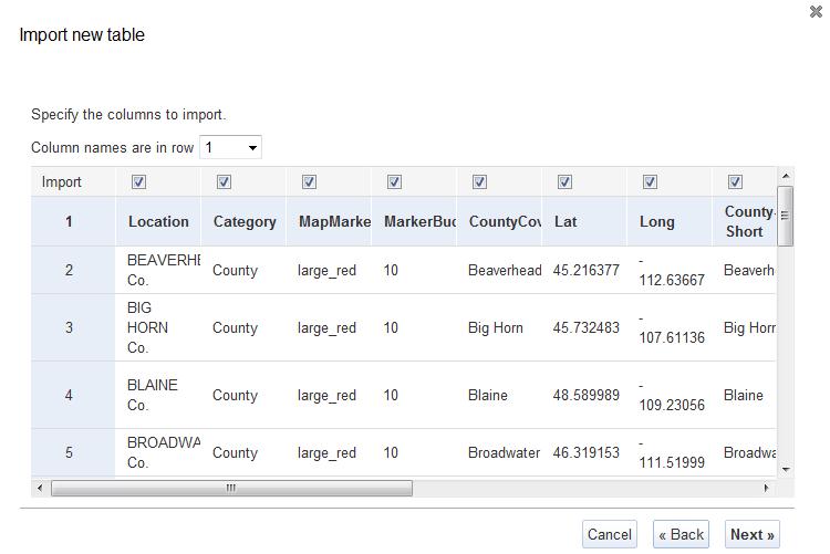
3 h. Click on the icon on the left edge of the screen. This will bring up a drop down menu, shown in Figure 4. Click on the Table (beta) menu item to start the upload process for an Excel spreadsheet, or if you have more than 400 rows of data, upload a file in a Comma Separated Value (CSV) file format. You can save an Excel file to a CSV format. Figure 4. i. Figure 5 shows the first step in uploading a file containing the data. Use the From this computer option and Click on the Browse button to navigate to where your file is stored. j. Once the file is selected, click on the Next button in the lower right corner of the screen, Figure 5. The next screen appears, Figure 6, which is a portion of your spreadsheet. This example is the file used to create the County Agent Map for Montana. Select which row the Column Names are in, most always row 1. You can also select columns to exclude by unchecking all columns you do not wish to import, Figure 6. All columns were imported from this table. Click the Next button in the lower right corner of Figure 6.

4 Figure 5. Figure 6.

5 k. Figure 7 shows the last step in the process of uploading data to a Fusion Table. This step allows you to enter meta data, which is data (information) about the data. You can fill this in as necessary or desired. Figure 7. l. Click the Finish button in the lower right corner. Figure 8 shows the next screen that appears, which is the Table view of the Fusion table. Note the menu under the name of the table in the top left portion of the Figure 8. This menu allows you to finish defining the information in the table before it can be used as a Fusion table. m. The next step is to define what each column contains and identify the location information contained in the table. To start this process, click on the word Edit in the word menu shown above. A drop down list, shown at right, appears. From this drop down, click on the Modify columns option. Another menu selection window appears, Figure 9.

6 Figure 8. Figure 9. n. During the conversion to a Fusion table, Google takes its best guess as to what type of information is stored in each column. Figure 9 show how you identify the type of information you want to assign to each column rather than using Google s best guess. The name of the first column is Location and you can see that column is highlighted in Figure 9. Google thinks the Type of data is Text and the Format is None. In this
7 Figure 10. instance, it is correct. The column headings of Category, MapMarker and MarkerBucket are also correctly identified. The column labeled CountyCoverage is identified as Location information. If we click on the CountyCoverage column label to highlight it, we get a slightly different view of the type of information Google thinks this column contains on the right hand side of this pop up window, Figure 10. o. Figure 10 shows Google thinks this column contains Location information, and it does. It contains the names of counties in Montana. Google recognizes many common location references such as state, county and city names, latitude and longitude (and X,Y) pair, physical street addresses such as 1324 North Sixth Street, or 2730 South 19 th, etc. Street addresses are a special case because Google will geocode a list of street addresses for you if you do not know the Lat and Long for each row of data. The physical street address should be accompanied by a state and city name in the same row to help Google find the information. More on geocoding later. p. We want to change the information listed in the Type box from Location to Text. Click the drop down arrow next to the Location identifier and select Text from the list. Click on the next column label on the list which, left side, which is Lat. Figure 11 shows the results.
8 Figure 11. q. When the Lat column label is highlighted, Google thinks it is also location information and in this instance it is also correct. When using latitude and longitude for X,Y coordinates, the columns must be together, but they do not have to have any particular names. It is just easier to identify and work with the columns if they are named something like Lat and Long. Figure 11 shows the Type as Location, the format is None which is OK. The last item on the right edge is Two column location: and it lists the name of the two columns starting with the one highlighted. The box in front of Two column location: is checked. If not check it. If you upload data and Google does not automatically recognize the Lat Long data, this is where you tell Google to use the columns that contain that data. These two columns containing the location information do not have to be adjacent. If you hare geocoding your data, you do not have Lat Long numbers, you can select the columns you wish to use here, which may not be adjacent in your data file. r. Save your table definitions by clicking on the Save Icon, lower left corner of Figure 11, when you are finished. You retun to the Table View. s. When you get the Lat Long columns identified as your location information columns, the rest of the columns can be set to Text values. How you intend to use this information across platforms may determine how the rest of the columns should be specified, i.e. phone number is a number field rather than a text field, etc. We are still exploring this as of Dec. 21, i. Possible platforms used by the intended audience may include: 1. Just the web a. Can limit interactivity but delivers information 2. Tablets and smart phones a. Can access the web site, but can not utilize some of the capabilities of these platforms, such as dial a phone number, send an . i. Note with these platforms, a producer could take a picture of a bug with his smart phone and send to his local County Agent, or directly to a diagnostic lab.

9 Remaining Steps: 5. You are ready to view the mapped data. In the table view, click on Visualize and then Map and Google will display your mapped data. Figure 12. a. Explore the map. Zoom in and out, pan in all directions, click on the red dots to see the automatic popup window Google Fusion Tables creates. This will be helpful in understand the next few steps. Figure 12. Contains the Montana Agent List and the Farm Management specialists from the 13 Western states, as per the last circulated mailing list.

10 6. Customizing your map: a. Now that the map has been created, you can change some of the display characteristics and what information is actually displayed from the table you uploaded. b. Reasons to customize your map display: i. The final destination may require features that are not supported completely using just Google Fusion tables and the web. 1. Activate data included in tables such as phone numbers and address so the user can access these via Tablets and smart phones. 2. Scaling on devises may require some custom programming to display correctly on tablets and smart phones 3. Gives control to use custom icons rather than Google s built in list of Icons. a. This link puts you within the Fusion table s development screen so you may need to have a Google account and be signed for this to work. b. Going from Fusion Tables defaults to the Google API provides tremendous flexibility in the look and feel of your application. i. May create additional display problems if the data in the table is intended strictly for the web. ii. Need Java Script and HTML programming capabilities iii. Buy your IT support/programmer lunch. c. To customize your map display, there is an additional set of menu options available when the map is actually displayed. These items are directly above the map. Note that some are active and some are greyed out. Figure 13. i. Active are Configure info window; Configure styles; Export to KML ii. The greyed out options will only become available when you make your Fusion table Public instead of private. The default is private. iii. To share your work, click on the Share Icon, upper right corner, Figure 13. Figure 13. iv. Clicking on the Share Icon allows you to specify how the data is shared, and who has access to edit the Fusion table data. Figure 14. Figure 14 shows this popup after I have specified who else can have access to edit this table and how it is to be shared, in this instance as Unlisted. v. When you have set these parameters to your needs, click on the X in the upper right corner to close this Share setup screen. vi. The links that were previous greyed out are now active. Figure 15.

11 Figure 14. Figure 15. vii. To start customizing your map display, to the extent that Google Fusions tables allows, click on the Configure info window link shown in Figure 15. This allows you to select the columns that are displayed in the popup window when you click on one of the red dots. Selecting the information included is a simple click to activate or deactivate information in a column. Figure 16. Click Save to exit. 1. Note that the popup window is configure by html code shown on the right hand edge of the screen, which means you can have a great deal of control over how the popup looks if you move from Google Fusion tables to the Google API.

12 Figure 16. viii. When the info window is configure, click on Configure styles. This popup window allows you to change the markers placed on the map, which defaults to little red dots, Figure 17. Figure 17.
13 Figure 18. ix. The popup shown in Figure 17 contains both a menu of things to change on the left hand edge and a set of styles tabs to change how each menu item is displayed. This document deals only with the marker styles. If a one size fits all display fits your needs, you can leave the display as is, or you can at least change the type of marker displayed on the map. Click on the drop down arrow next to the small red dot. 1. The marker display chosen may depend on the intended final destination of this web site/app. In our initial efforts, we found that the small red dots were not sensitive enough to be used effectively on a smart phone screen. We switched to a set of bigger markers. x. The second tab allows you to select a column within your Fusion Table that will change the map marker based on a label entered in this column. See Figure 8, the column labeled MapMarker. Also refer to the handout or Excel spreadsheet containing the original data. Click on MapMarker to specify the column, Figure 18. xi. To learn more about map marker options and procedures use this link. This link is also available within Fusion tables. After you click on the MapMarker column, Figure 18, the display will change and there will be a Learn more link on the screen just below the box that displays MapMarker as the column selected.

14 Figure 19. xii. The last tab on the Configure styles popup is labeled Buckets. This tab allows you to select a color scheme for the map markers using a column in the spreadsheet. See Figure 8 and Figure 9. The column labeled MarkerBucket, not completely displayed in Figure 8, is a set of numbers assigned to a particular category of data. You can categorize the data however you wish. In this example, Montana Agents were all assigned the number 10 in the Fusion table before it was uploaded. Reservations were assigned the number 25 and Tribal Community Colleges were assigned the number 35. The Western Extension Committee members were assigned the number 45. Note that the Bucket marker style was not used in this map, but an allowance was made in the data by adding a column of numbers that could be used. You can specify how many categories your data has and select a marker for each category = Bucket. xiii. Your map display should now look like Figure 19.

15 7. KML options listed in the Visualize>Map mode as shown in Figure 19. a. There are two KML options listed that allows the user to generate a packaged code that can be distributed in a single file with a KML extension, Export to KML or listed on a network, Get KML network link. These allow the distribution of this information in Google maps and Google Earth. An individual file, Export to KML, can be shared with users via , web link etc. and the user then loads the KML file, into Google Earth for example, and the original Fusion table data is displayed in Google Earth, or Google Maps as the user wishes. 8. The Get embeddable link option produces a snippet of code that can be cut and pasted into an existing web page. If you click on this link, the display changes to show the link source code, Figure 20. The source code shown in Figure 20 is also is shown directly below. When you embed this code into an existing page, you can change the size of the display from the default of 500 x 300 to as large as you wish. The code snippet below generates a window within a web site. Important Note: Google uses the image as displayed on the screen before you use the Get embeddable link option as a reference point, for how it displays your map. You should center up and scale the display on your computer to look like what you want the end user to see when the map is loaded for them the first time. Source Code snippet: <iframe width="500px" height="300px" scrolling="no" src=" e&lat= &lng= &z=5&t=1&l=col5"></iframe> Figure 20.


16 9. Another option to get a shareable link is to use the Get Link button in the upper right corner. This button provides a different http address than the Get embeddable link menu item and the display utilizes the entire browsers window space, which you may or may not like. Figure 21 and Figure 22. Figure 21. Figure 22. Using the Get Link button and pasting the link into a browser. Note that this link puts you back in the Fusion tables menu. This may only work for people who you have Shared this table with.

17 Figure 23. Used the snippet code and changed the scale to 1000 x 800. Link to this site is What happens if you do not have Lat and Long numbers for each row/point. a. As mentioned previously, Google Fusion tables recognizes several types of location information. For example, Google recognizes and will use State, County and City names as well as Physical street Address, as Location information. If these are contained in separate columns when you upload a file, you can identify the columns with this information as Location type columns. After you have set up your table using the process just described in 4a through 4s, save these settings and you will be taken back to the Table View. b. The next step is to use the Visualize>Map menu sequence and Google will automatically geocode all of your with the information your provided, to the best of its ability. c. OR, use the geocoding site I always sign out of my Google Account when done. Click on your name, displayed in the black bar, right hand edge, Figure 22, and then click Sign Out.
18 Appendix A: Software and/or Tablet and Smart Phone Apps Development Outline A) Description of App and/or problem/market need it addresses: Target Audience: Potential applicability (geographic area of distribution): Estimated audience size, your ( ) Lowest and ( ) Highest: B) Data Source(s): Describe data Agency, organization, contact person, etc. Data is Static 1 or Dynamic 2 1 Updated infrequently: weekly, monthly, annually, periodically 2 Updated, real time, daily, weekly C) Analytics: Describe what is to be done with the data/information: D) Describe results: E) Recommended technology: F) Possible partner agencies and organizations: G) Required resources:
Mapping with Google Fusion Tables
 Mapping with Google Fusion Tables You will learn how to transform location information stored in an Excel spreadsheet to a format that can be mapped directly with Google Fusion Tables. Format of Data within
Table JESSICA MILLER WCLS COORDINATOR
 Google Fusion Table JESSICA MILLER WCLS COORDINATOR JMILLER@CITLIB.ORG Purpose Google Fusion Tables is a data management tool that allows you to come to new conclusions about your data by seeing it in
Google Fusion Tables Tutorial: Displaying Facilities in Discharge Monitoring Reports (DMR)
") Google Fusion Tables Tutorial: Displaying Facilities in Discharge Monitoring Reports (DMR) This tutorial will introduce you to the following: Obtaining Data from EPA DMR, and relevant base map materials
Google Fusion Tables Tutorial: Displaying Facilities in Discharge Monitoring Reports (DMR) This tutorial will introduce you to the following: Obtaining Data from EPA DMR, and relevant base map materials
Mapping with Google Fusion Tables
 Mapping with Google Fusion Tables You will learn how to transform location information stored in an Excel spreadsheet to a format that can be mapped directly with the Google Fusion Tables. Format of Data
Google FusionTables for Global Health User Manual
 Google FusionTables for Global Health User Manual Version: January 2015 1 1. Introduction... 3 Use Requirements... 3 Video Tutorials... 3 2. Getting started with Google FusionTables... 4 2.1. Setup...
MS2. Modern Traffic Analytics ms2soft.com
 MS2 Modern Traffic Analytics ms2soft.com Updated: October 31, 2014 Table of Contents 1 Introduction 3 2 Search Types 6 3.1 Search by: Study Location 11 3.2 Search by: Crash Data 12 3.3 Search Results Page
Tutorial for Lane County Mapping Applications
 Tutorial for Lane County Mapping Applications Contents Overview... 2 Tools... 2 Navigation Tools... 3 Display Tools... 5 Information Tools... 6 Sharing Tools... 7 Common Tasks... 9 Identify or Show Data
CIC Scheduled Reports
 CIC Scheduled Reports User Guide 2018 R2 Last updated 2018-02-08 (See Change Log for summary of changes.) Abstract Scheduled Reports is a reporting tool that schedules Crystal Reports to run and distributes
This worksheet will walk you through the basics of creating a digital map using CARTO, a cloud-based GIS and web mapping tools platform.
 MappingBasics This worksheet will walk you through the basics of creating a digital map using CARTO, a cloud-based GIS and web mapping tools platform. The goals of this exercise are: Learn how to geocode
Brianna Nelson Updated 6/30/15 HOW TO: Docs, Sheets, Slides, Calendar, & Drive. English
 Brianna Nelson Updated 6/30/15 HOW TO: Docs, Sheets, Slides, Calendar, & Drive English ABOUT Use this guide to write papers, create spreadsheets, give presentations, manage your time, and save your files
In order to follow this set of directions you will need the following
 How to Create Maps & Figures in ArcView 9x In order to follow this set of directions you will need the following 1) the Jenny s Louisiana GIS Instructional CD 2) a computer with ArcGIS on it (version 9.0
Instructions for Getting Data into Google Earth
 Instructions for Getting Data into Google Earth 21/10/14 1. Making simple placemarks in Google Earth from an Excel table An excel sheet can be set up with lat/long data and then put through a website like
Community Health Maps Lab Series
 Community Health Maps Lab Series Lab 6 Data Visualization with Carto Objective Understand how to upload and style data with Carto to create an online visualization of your data Document Version: 2017-08-28(Final)
Mn/DOT MnCMAT Crash Analysis Application Help
 Mn/DOT MnCMAT Crash Analysis Application Contents Login... 5 User Login Dialog... 5 Login... 5 Request Access Dialog... 5 Forgotten Password Dialog... 6 Create/Open Project... 7 Create/Open Project Dialog...
QUICK HELP GUIDE. Traffic Signal Management System (TSMS) Modern Traffic Analytics
 Modern Traffic Analytics") QUICK HELP GUIDE Traffic Signal Management System (TSMS) Modern Traffic Analytics www.ms2soft.cotm Table of Contents 1.0 Introduction...1 2.0 Search Types...4 3.0 Map Interactions...5 4.0 Reports...8 5.0
QUICK HELP GUIDE Traffic Signal Management System (TSMS) Modern Traffic Analytics www.ms2soft.cotm Table of Contents 1.0 Introduction...1 2.0 Search Types...4 3.0 Map Interactions...5 4.0 Reports...8 5.0
ArcGIS Online (AGOL) Quick Start Guide Fall 2018
 Quick Start Guide Fall 2018") ArcGIS Online (AGOL) Quick Start Guide Fall 2018 ArcGIS Online (AGOL) is a web mapping tool available to UC Merced faculty, students and staff. The Spatial Analysis and Research Center (SpARC) provides
ArcGIS Online (AGOL) Quick Start Guide Fall 2018 ArcGIS Online (AGOL) is a web mapping tool available to UC Merced faculty, students and staff. The Spatial Analysis and Research Center (SpARC) provides
Address Management User Guide. PowerSchool 8.x Student Information System
 PowerSchool 8.x Student Information System Released July 2014 Document Owner: Documentation Services This edition applies to Release 8.0.1 of the PowerSchool software and to all subsequent releases and
MAKING MAPS WITH GOOGLE FUSION TABLES. (Data for this tutorial at
 MAKING MAPS WITH GOOGLE FUSION TABLES (Data for this tutorial at www.peteraldhous.com/data) Thanks to Google Fusion Tables, creating maps from data and embedding them on a web page is now easy. We re going
You will demonstrate two strategies commonly used to geocode data, and demonstrate an ability to gather address data from a typical state database.
 Steve Graves Forensic Geography Lab: Preparing Address Data for Geocoding Background One of the most commonly used tools for people using GIS is geocoding. Geocoding, also sometimes called address mapping,
How to use the DuPage County Parcel Viewer Interactive Web Mapping Application.
 How to use the DuPage County Parcel Viewer Interactive Web Mapping Application. Parcel Viewer URL: URL: http://gis.dupageco.org/parcelviewer/ Initial View (And frequently asked questions) Parcel Search
GIS DATA SUBMISSION USER GUIDE. Innovation and Networks Executive Agency
 Innovation and Networks Executive Agency GIS DATA SUBMISSION USER GUIDE Innovation and Networks Executive Agency (INEA) W910 Chaussée de Wavre 910 B-1049 Brussels, Belgium Tel: +32 (0)2 29 95252 Fax: +32
Address Management User Guide. PowerSchool 6.0 Student Information System
 User Guide PowerSchool 6.0 Student Information System Released June 2009 Document Owner: Document Services This edition applies to Release 6.0 of the PowerSchool Premier software and to all subsequent
RG3 Meter Company. AMR Software Solutions. Operation and Procedure Manual. for. Field Meter Reading.
 RG3 Meter Company AMR Software Solutions Operation and Procedure Manual for Field Meter Reading www.rg3meter.com TABLE OF CONTENTS I Import Data from Billing System to AMRSS Server Software Pg 3 II Mobile
BC Spatial Member Map Viewer. Version 2.0. User Guide. May 2015
 BC Spatial Member Map Viewer Version 2.0 User Guide May 2015 1 P a g e Revised: 16 June 2015 Contents Contents... 2 Introduction... 4 System Requirements... 5 BC Spatial Map Viewer... 6 I. Navigation Tools...
Geocoding Reference USA data in ArcMap 9.3
 Tufts GIS Tip Sheet Geocoding Reference USA data in ArcMap 9.3 Written by Barbara Parmenter Revised 3/1/2011 In this exercise, you will map businesses or services for a town in the Boston metropolitan
Supply Chain Guru Network Optimization Tutorial. Version 8.2
 Supply Chain Guru Network Optimization Tutorial Version 8.2 Supply Chain Guru 8.2 Network Optimization Tutorial January 2015 Copyright 2015 LLamasoft, Inc. All Rights Reserved. PC*MILER and ALK are registered
MS2. Modern Traffic Analytics ms2soft.com
 MS2 Modern Traffic Analytics ms2soft.com Updated: October 31, 2014 The Traffic Count Database System (TCDS) module is a powerful tool for the traffic engineer or planner to organize an agency's traffic
EXCEL BASICS: MICROSOFT OFFICE 2007
 EXCEL BASICS: MICROSOFT OFFICE 2007 GETTING STARTED PAGE 02 Prerequisites What You Will Learn USING MICROSOFT EXCEL PAGE 03 Opening Microsoft Excel Microsoft Excel Features Keyboard Review Pointer Shapes
Full Search Map Tab. This map is the result of selecting the Map tab within Full Search.
 Full Search Map Tab This map is the result of selecting the Map tab within Full Search. This map can be used when defining your parameters starting from a Full Search. Once you have entered your desired
NAACCR Webinar Exercises. May 6, 2010 Kevin Henry Francis Boscoe
 NAACCR Webinar Exercises May 6, 2010 Kevin Henry Francis Boscoe EXERCISE 1 Google Earth and Geocoding Individual Cases Part 1 Introduction to Google Earth 1 Open Google Earth Click Start Programs Google
Chapter 7. A Quick Tour of ArcGIS Pro
 Chapter 7 A Quick Tour of ArcGIS Pro Skills you will learn: This tutorial is intended to get you going using ArcGIS Pro, a new desktop application that is part of ArcGIS Desktop. A separate tutorial gives
How to Transfer Your Contact Information Into Microsoft Outlook 2010
 How to Transfer Your Contact Information Into Microsoft Outlook 2010 Your Contacts Exported To an Excel Spreadsheet (CSV Format ) Now Located on a Device or Computer Then To Outlook 2010 on an L&F Computer
Store Locator for Magento 2. User Guide
 Store Locator for Magento 2 User Guide Table of Contents 1. Store Locator Configuration 1.1. Accessing the Extension Main Setting 1.2. General 1.3. Service API and Comments 1.4. Store Search 2. Store Locator
NAACCR Geocoding Tutorial
 NAACCR Geocoding Tutorial Introduction The goal of the tutorial is to familiarize you with the NAACCR online geocoder. The NAACCR geocoder can be used to geocode one address at a time or in batch mode
The purpose of this tutorial is to introduce you to the Construct 2 program. First, you will be told where the software is located on the computer
 Learning Targets: Students will be introduced to industry recognized game development software Students will learn how to navigate within the software Students will learn the basics on how to use Construct
Propel PRO User Guide
 Propel PRO User Guide Propel PRO Version 3.2.0a Page 1 Welcome to the latest version of Propel PRO which offers fast performance and easy navigation. Please refer to this user guide for common features
EXCEL BASICS: MICROSOFT OFFICE 2010
 EXCEL BASICS: MICROSOFT OFFICE 2010 GETTING STARTED PAGE 02 Prerequisites What You Will Learn USING MICROSOFT EXCEL PAGE 03 Opening Microsoft Excel Microsoft Excel Features Keyboard Review Pointer Shapes
StreetSync Basic Quick-Start
 RouteSolutions Inc. StreetSync Basic Quick-Start For the StreetSync Basic Route Planning System Copyright 2005-2010 Route Solutions, Inc. All Rights Reserved 1.0 1 ABOUT STREETSYNC BASIC StreetSync Basic
Overview. Setting Up. Geospatial Centre University of Waterloo May 2014
 Overview ArcGIS Online is a web-based mapping and app-building site created by Esri, the world leader in GIS software. In an effort to empower users of all levels to create interactive maps and applications
IMAP MANUAL UTILITY NOTIFICATION CENTER AN INSTRUCTIONAL GUIDE TO VIEWING AND MAPPING DISTRICT POLYGONS ONLINE.
 UTILITY NOTIFICATION CENTER IMAP MANUAL AN INSTRUCTIONAL GUIDE TO VIEWING AND MAPPING DISTRICT POLYGONS ONLINE 2013 LAST UPDATE: JUNE 2013 TABLE OF CONTENTS Introduction 1 IMAP at-a-glance 2 Logging In
Listing Input (Add/Edit) Tips
 Tips") LISTING INPUT 1. Click on the Add/Edit tab in Matrix to begin & then click on Add new 2. Select a Property Type Form 3. AutoFill from Realist or Other Options The first screen of Input gives you multiple
LISTING INPUT 1. Click on the Add/Edit tab in Matrix to begin & then click on Add new 2. Select a Property Type Form 3. AutoFill from Realist or Other Options The first screen of Input gives you multiple
RURAL ROAD RAM APP QUICK START GUIDE
 RURAL ROAD RAM Mobile App Quick Start Guide v3.0 1 RURAL ROAD RAM APP QUICK START GUIDE The following provides the setup instructions and basic user guidance for the Rural Road RAM mobile application.
Tips on Excel. Discover some tips to organize and lay out your Excel file and convert it into a CSV or PDF file.
 Tips on Excel Your business partners or retailers are listed in an Excel file and you want to put them on an interactive map? It's simple with the Click2map's Editor. A simple import process exists to
Table of contents. DMXzone Google Maps Manual DMXzone.com
 Table of contents Table of contents... 1 About DMXzone Google Maps... 2 Features in Detail... 3 The Basics: Insterting DMXzone Google Maps on a Page... 16 Advanced: Creating Dynamic DMXzone Google Maps...
Vision-e 19 Gloria Lane Fairfield, NJ
 Version.0 Section Page 1.0 Manage User Licenses 3 1.1 Geocoding Your Records 4 1.2 Enabling Custom Objects 5 1.3 Create a Map 5 1.4 Import Report 6 1.5 Edit a Map 6 1.6 Clone a Map 7 1.7 Delete a Map 7
Analysing crime data in Maps for Office and ArcGIS Online
 Analysing crime data in Maps for Office and ArcGIS Online For non-commercial use only by schools and universities Esri UK GIS for School Programme www.esriuk.com/schools Introduction ArcGIS Online is a
DOING MORE WITH EXCEL: MICROSOFT OFFICE 2013
 DOING MORE WITH EXCEL: MICROSOFT OFFICE 2013 GETTING STARTED PAGE 02 Prerequisites What You Will Learn MORE TASKS IN MICROSOFT EXCEL PAGE 03 Cutting, Copying, and Pasting Data Basic Formulas Filling Data
Mapping discarded needles in Fusion Tables Tutorial
 Mapping discarded needles in Fusion Tables Tutorial In the previous tutorials, we ve learned how to turn pivot tables into heat maps and place colour code geographic points using markers that Fusion Tables
St. Joseph County. GIS Department FetchGIS Web Map Tutorial
 St. Joseph County GIS Department FetchGIS Web Map Tutorial 2 Table of Contents Contents Slide #(s) Where to Find the Web Map 3 Disclaimer 4 Turning On and Off Map Layers 5 Searching for Parcels 6 More
Tutorial for Importing Open Green Map Sites into Google Earth
 Tutorial for Importing Open Green Map Sites into Google Earth Step 1. Download your Open Green Map data files by logging in on Open Green Map and viewing your map(s). Choose the Import/Export tab over
HOW TO USE THE EXPORT FEATURE IN LCL
 HOW TO USE THE EXPORT FEATURE IN LCL In LCL go to the Go To menu and select Export. Select the items that you would like to have exported to the file. To select them you will click the item in the left
SAGIS Property Map Viewer Instruction Manual Instructions for using the SAGIS Property Map Viewer. Published December 21, 2018.
 SAGIS Property Map Viewer Instruction Manual www.sagis.org/map Instructions for using the SAGIS Property Map Viewer. Published December 21, 2018. 1 Instructional Videos Click on a link to watch a video
ArcGIS Online. Overview. Setting Up
 ArcGIS Online Overview ArcGIS Online is a web-based mapping and app-building site created by Esri, the world leader in GIS software. In an effort to empower users of all levels to create interactive maps
Find nearest dealer. Users guide
 Find nearest dealer Users guide January 2017 Digital Media, Group Marketing 1 Table of contents 1. Access to backend... 3 2 Front page... 4 2.1 Left navigation... 5 3 Stockists... 6 3.1 Overview... 6 3.2
Rainforest Alliance. Spatial data requirements and guidance. June 2018 Version 1.1
 Rainforest Alliance Spatial data requirements and guidance June 2018 Version 1.1 More information? For more information about the Rainforest Alliance, visit www.rainforest-alliance.org or contact info@ra.org
Web Configurator. Guideline for using the configurator on. Date 11th Nov, 2016 Version 3.01
 Web Configurator Guideline for using the configurator on https://configurator.linetgroup.com/ Content 1 Purpose... 3 2 Access... 3 3 Navigation... 4 4 Existing model numbers... 5 5 New model numbers...
Map Direct Lite. Quick Start Guide: Search Results 05/14/2018
 Map Direct Lite Quick Start Guide: Search Results 05/14/2018 Contents Quick Start Guide: Search Results... 1 Search Results in Map Direct Lite.... 2 Where is the Search Results Panel?... 3 Search Result
City of La Crosse Online Mapping Website Help Document
 City of La Crosse Online Mapping Website Help Document This document was created to assist in using the new City of La Crosse online mapping sites. When the website is first opened, a map showing the City
Multi-Sponsor Environment. SAS Clinical Trial Data Transparency User Guide
 Multi-Sponsor Environment SAS Clinical Trial Data Transparency User Guide Version 6.0 01 December 2017 Contents Contents 1 Overview...1 2 Setting up Your Account...3 2.1 Completing the Initial Email and
Volunteer Hours Report Generator This guide is to help you get started on using the Automated Volunteer hours Report Generator.
 Volunteer Hours Report Generator This guide is to help you get started on using the Automated Volunteer hours Report Generator. Table of Contents Intent Accessing the Volunteer Reporting Spreadsheet w
Census Small Area Population Statistics (SAPS) A Guide to using the SAPMAP web application
 A Guide to using the SAPMAP web application") Census Small Area Population Statistics (SAPS) A Guide to using the SAPMAP web application 1 When you open the application you will see this page. This screen gives a brief description of the application.
Census Small Area Population Statistics (SAPS) A Guide to using the SAPMAP web application 1 When you open the application you will see this page. This screen gives a brief description of the application.
Google Earth. Tutorials. Tutorial 2: Annotating Google Earth
 Google Earth Tutorials Tutorial 2: Annotating Google Earth Google Earth makes it easy to create a map with annotations - you can add placemarks (points), paths (lines), polygons in Google Earth, and add
GPS to GIS Tutorial Exploration of Native Plants
 Grossmont College Introduction to GIScience NAME: Instructors: Curran & Goodman 1 GPS to GIS Tutorial Exploration of Native Plants 1. Create a folder on your USB drive titled: GPS1 2. Using your GPS receiver,
RAPIDMAP Geocortex HTML5 Viewer Manual
 RAPIDMAP Geocortex HTML5 Viewer Manual This site was developed using the evolving HTML5 web standard and should work in most modern browsers including IE, Safari, Chrome and Firefox. Even though it was
Google Docs Handout. Carol LaRow
 Google Docs Handout Easy-To-Use Online Tool Carol LaRow Create documents and collaborate in real time, inside a WEB browser window. Or, work on documents when it s convenient. Features: Use one of four
GIS DATA SUBMISSION USER GUIDE. Innovation and Networks Executive Agency
 Innovation and Networks Executive Agency GIS DATA SUBMISSION USER GUIDE Innovation and Networks Executive Agency (INEA) W910 Chaussée de Wavre 910 B-1049 Brussels, Belgium Tel: +32 (0)2 29 95252 Fax: +32
Mail Merge for Gmail v2.0
 The Mail Merge with HTML Mail program will help you send personalized email messages in bulk using your Gmail account. What can Mail Merge for Gmail do? You can send messages in rich HTML, the message
Chapter 7. Geocoding in ArcGIS Desktop (ArcMap)
") Chapter 7 Geocoding in ArcGIS Desktop (ArcMap) Summary: In many cases, online geocoding services are all you will need to convert addresses and other location data into geographic data. When you have a
Chapter 7 Geocoding in ArcGIS Desktop (ArcMap) Summary: In many cases, online geocoding services are all you will need to convert addresses and other location data into geographic data. When you have a
The Data Journalist Chapter 7 tutorial Geocoding in ArcGIS Desktop
 The Data Journalist Chapter 7 tutorial Geocoding in ArcGIS Desktop Summary: In many cases, online geocoding services are all you will need to convert addresses and other location data into geographic data.
1. NJDEP Landscape 3.3 Viewer Interface
 Using the Landscape Project through NJDEP Landscape 3.3 Viewer Google Chrome or Mozilla Firefox are recommended for the use of this app. Navigate to the NJDEP-DFW s Landscape Project web page at www.njfishandwildlife.com/ensp/landscape/
NEBRASKA811 IMAP MANUAL AN INSTRUCTIONAL GUIDE TO VIEWING AND MAPPING DISTRICT POLYGONS ONLINE OCTOBER
 NEBRASKA811 IMAP MANUAL AN INSTRUCTIONAL GUIDE TO VIEWING AND MAPPING DISTRICT POLYGONS ONLINE 2013 OCTOBER 30 2013 TABLE OF CONTENTS Introduction 1 IMAP at-a-glance 2 Logging In 3 Understanding The Components
Tutorial for mapping Toronto s 2013 fire hydrant parking ticket data
 Tutorial for mapping Toronto s 2013 fire hydrant parking ticket data Toronto, like cities including Vancouver, Edmonton, Ottawa and Halifax, has an open data site with lots of great data to download. The
Introduction to SPSS
 Introduction to SPSS Purpose The purpose of this assignment is to introduce you to SPSS, the most commonly used statistical package in the social sciences. You will create a new data file and calculate
Google Docs Handout. Easy-To-Use Online Tool. Carol LaRow
 Google Docs Handout Easy-To-Use Online Tool Carol LaRow Create documents and collaborate in real time, inside a WEB browser window. Or, work on documents when it s convenient. Features: Word processing,
Using Syracuse Community Geography s MapSyracuse
 Using Syracuse Community Geography s MapSyracuse MapSyracuse allows the user to create custom maps with the data provided by Syracuse Community Geography. Starting with the basic template provided, you
Full Search Map Tab Overview
 FlexMLS Map Server Full Search Map Tab Overview The Full Search Map tab is a need to know module. It is accessible when you use Full Search under Search in the Main Menu tree of FlexMLS. This map can
Electronic Owner s Manual User Guide
 Electronic Owner s Manual User Guide I. Getting Started.... 1 Logging In.... 2 Additional Information... 2 II. Searching for an Existing EOM Form... 5 III. Creating a New EOM Form.. 5 IV. Modifying an
Using Mail Merge in Microsoft Word 2003
 Using Mail Merge in Microsoft Word 2003 Mail Merge Created: 12 April 2005 Note: You should be competent in Microsoft Word before you attempt this Tutorial. Open Microsoft Word 2003 Beginning the Merge
U N I V E R S I T Y O F K E N T U C K Y. efacts 2-click Interactive Building Information Map ~ Help Guide ~ Revised January 20, 2016
 U N I V E R S I T Y O F K E N T U C K Y efacts 2-click Interactive Building Information Map ~ Help Guide ~ Revised January 20, 2016 Contents BUILDING SEARCH... 3 A. FIND A CAMPUS LOCATION... 3 GRAPHICAL
How to Mail Merge PDF Documents
 How to Mail Merge PDF Documents A step-by-step guide to creating personalized documents using AutoMailMerge plug-in for Adobe Acrobat Table of Contents What is a mail merge?...2 What do I need to start?...2
Login: Quick Guide for Qualtrics May 2018 Training:
 Qualtrics Basics Creating a New Qualtrics Account Note: Anyone with a Purdue career account can create a Qualtrics account. 1. In a Web browser, navigate to purdue.qualtrics.com. 2. Enter your Purdue Career
Geocoding vs. Add XY Data using Reference USA data in ArcMap
 Geocoding vs. Add XY Data using Reference USA data in ArcMap 10.4.1 Written by Barbara Parmenter. Revised by Carolyn Talmadge 2/27/2017 GETTING BUSINESS DATA FROM REFERENCE USA BY NAICS AND CITY... 2 MODIFY
Zip Code Locator Software Hosted Solution
 Zip Code Locator Software Hosted Solution USER S GUIDE / Documentation www.geosprawl.com Document Version Control Version Date Change Description 1.0 12/17/2008 Created 2008Reachoutside, LLC. Do not copy
1. Start ArcMap by going to the Start menu > All Programs > ArcGIS > ArcMap.
 Learning ArcGIS: Introduction to ArcMap 10.1 The Map Document Feature Manipulation Navigating ArcMap Map Documents, Layers, and Features Shapes, Location, and Attribute Data Symbology Zoom, Pan and Map
Autoresponder Guide. David Sharpe
 David Sharpe There are two autoresponders that I personally use and recommended AWeber and Sendlane. AWeber AWeber is a great service to use if you already have a website you are using. You can easily
Introduction to using QGIS for Archaeology and History Workshop by the Empirical Reasoning Center
 Introduction to using QGIS for Archaeology and History Workshop by the Empirical Reasoning Center In this workshop, we will cover the basics of working with spatial data, as well as its main uses for archaeology.
Introduction to Social Explorer
 Introduction to Social Explorer Janine Billadello, Geospatial Data Lab, Baruch College October 1, 2015 Abstract This tutorial will introduce you to Social Explorer, an online mapping interface that allows
MapInfo Stratus. Version 41. MapInfo Stratus Administration Guide
 MapInfo Stratus Version 41 MapInfo Stratus Administration Guide Contents Chapter 1: Getting Started...7 Signing In and Out...8 Home...8 Version Number and Build Number...9 Using MapInfo Stratus Administration
Scantron Operating Instructions
 Scantron Operating Instructions Getting Started: 1. Remove the cover and turn on the Scantron machine. The ON/OFF switch is located on the back on the machine towards your right. 2. Log in to the computer
Part 2: Build your own Map Tour with ArcGIS Online
 Part 2: Build your own Map Tour with ArcGIS Online Tutorial Overview In this tutorial, students will create and publish their own Map Tour application, a type of Story Map Web application, through ArcGIS
TRAINING GUIDE. Lucity Webmap 2017r2
 TRAINING GUIDE Lucity Webmap 2017r2 Web Map The Lucity Web Map provides a way for users to see and work with their asset and work data. This allows them to see relationships between objects and plan work
Chapter 6. Building Maps with ArcGIS Online
 Chapter 6 Building Maps with ArcGIS Online Summary: ArcGIS Online is an on-line mapping software that allows you to upload tables with latitude and longitude geographic coordinates to create map layers
Reporter Tutorial: Intermediate
 Reporter Tutorial: Intermediate Refer to the following sections for guidance on using these features of the Reporter: Lesson 1 Data Relationships in Reports Lesson 2 Create Tutorial Training Report Lesson
Online National Mosquito Surveillance Database. User Guide
 Online National Mosquito Surveillance Database User Guide Version 4 Updated November 2018 Contents Introduction... 3 Database Operation... 3 Access... 3 Users... 3 New Users... 4 Logging In... 4 Entering
Newaygo County Web Map
 Newaygo County Web Map Address/Parcel/Parcel Owner Search Map Overview Zoom Back to default extent Use your current location if allowable Widget Panel At the top of the map is a search function used for
Mapping Tabular Data Display XY points from csv
 Mapping Tabular Data Display XY points from csv Materials needed: AussiePublicToilets.csv. [1] Open and examine the data: Open ArcMap and use the Add Data button to add the table AussiePublicToilets.csv
Geocoding Reference USA data in ArcMap 10.1
 Geocoding Reference USA data in ArcMap 10.1 Written by Barbara Parmenter, revised 2/21/2014 GETTING BUSINESS DATA FROM REFERENCE USA BY NAICS AND CITY... 2 MODIFY YOUR EXCEL FILE... 5 STARTING ARCMAP...
Remote Access Guide. https://remote.lghealth.org
 Remote Access Guide https://remote.lghealth.org Created by: Joshua Steele Revision 1.0 7/14/2015 Table of Contents I. Remote Access using Internet Explorer... 2 II. Remote Access using Google Chrome...
Open Microsoft Word: click the Start button, click Programs> Microsoft Office> Microsoft Office Word 2007.
 Microsoft Word 2007 Mail Merge Letter The information below is devoted to using Mail Merge to create a letter in Microsoft Word. Please note this is an advanced Word function, you should be comfortable
Fusion. CBR Fusion MLS Level 1 Core Functions. Class Handout
 Fusion 1 CBR Fusion MLS Level 1 Core Functions Class Handout GETTING STARTED IN FUSION Logging On and Off To log on to Fusion MLS: 1. Type your user name in the User ID box. 2. Type your password in the