Maps on the Web. Chapter 1. Emmanuel Stefanakis.
|
|
|
- Cori Gardner
- 6 years ago
- Views:
Transcription

1 Stefanakis, E., Web Mapping and Geospatial Web Services. CreateSpace Independent Publ. [In English], pp.168. Get a copy from Amazon Chapter 1 Maps on the Web Emmanuel Stefanakis
2 Publishing Maps on the Web The World Wide Web A common means of publishing maps Web maps Million of people use web maps daily Few of them know how they are actually generated 2
3 The Web Communication of computers Client-Server Architecture. GET CLIENT HTTP/HTML SERVER PUT 3
4 Publishing Maps on the Web Two approaches Static maps Apply the basic web resources Interactive maps Enriched functionality by extending The client side functionality The server side functionality 4
5 Static Maps GET server/unb.htm CLIENT HTTP SERVER PUT { unb.htm, map.jpg } html text (unb.htm) < p>university OF NEW BRUNSWICK< /p> <img src= map.jpg > map / image map.jpg 5
6 Static Maps <html> <head> <title>unb Campus</title> </head> <body> <p>university OF NEW BRUNSWICK</p> <img src= "map.jpg"> </body> </html> 6
7 Static Maps Clickable maps Images may have sensitive areas associate a hyperlink to these areas 7


8 Static Maps Clickable maps 8
9 Static Maps Clickable maps <html> <head> <title>unb Campus</title> </head> <body> <p>university OF NEW BRUNSWICK</p> <img src="map.jpg" width="319" height="424" usemap="#unbmap"> <p>click on the image to see more</p> <map name="unbmap"> <area href="oldartsbuilding.jpg" shape="polygon" coords="113,315, 101,334, 164,372, 172,346"> <area href=" shape="rect" coords="93,39, 135,94"> <area href="busstop.jpg" shape="circle" coords="85,233, 10"> </map> </body> </html> 9
10 Interactive Maps Enriched functionality by extending the client side functionality the server side functionality GET CLIENT HTTP/HTML SERVER PUT 10
11 Interactive Maps Enriched functionality by extending the client side functionality the server side functionality GET CLIENT HTTP/HTML SERVER PUT 11
12 Extend the Client-side Plugins make the web browser capable to read and process additional formats plugin GET CLIENT HTTP/HTML SERVER PUT 12
13 Extend the Client-side Plugins PDF Reader (plugin) GET server/unb.htm CLIENT HTTP SERVER PUT { unb.htm, map.pdf } PDF Reader toolbox html text (unb.htm) < p>university OF NEW BRUNSWICK< /p> <img src= map.pdf > map / image map.pdf 13
14 Extend the Client-side Plugins Scalable Vector Graphics (SVG) is a language for describing two-dimensional graphics and graphical applications it is based on the XML standard it describes Content + Map Symbols +
15 Extend the Client-side Plugins Scalable Vector Graphics (SVG) A W3C standard (current version 1.1) SVG Document Type Declaration (DTD) <!DOCTYPE svg PUBLIC "-//W3C//DTD SVG 1.1//EN "
16 16
")
17 Extend the Client-side Plugins Scalable Vector Graphics (SVG)

18 SVG Plugins SVG
19 SVG <?xml version="1.0" standalone="no"?> <!DOCTYPE svg PUBLIC "-//W3C//DTD SVG 1.1//EN" " <svg width="100%" height="100%" version="1.1" xmlns=" <a xlink:href="parthenon.jpg"> <polygon points="408, , , ,306" style="fill:red; stroke:blue; stroke-width:1"/> </a>
20 Extend the Client-side Plugins Scalable Vector Graphics (SVG) An SVG document can be created from scratch in a text editor using an SVG editor as an output of another program» e.g., ArcGIS, Adobe Illustrator, etc. An SVG file can be viewed in a Web browser if an appropriate plugin is available
 < p> UNIVERSITY OF NEW BRUNSWICK</p> <object= map.svg > SVG (map.")
21 Extend the Client-side Plugins SVG SVG Viewer (plugin) GET CLIENT HTTP SERVER PUT { unb.htm, map.svg } html (unb.htm) < p> UNIVERSITY OF NEW BRUNSWICK</p> <object= map.svg > SVG (map.svg) <svg> <poly> </poly> <rect> </rect> </svg>


22 Extend the Client-side Plugins Google Earth Viewer 22
23 Extend the Client-side Java Applets JavaScripts (API s) The functionality varies from very simple button interactivity to a sophisticated mapping environment JVM GET CLIENT HTTP/HTML SERVER Java Virtual Machine PUT 23


24 Extend the Client-side Java Applets Examples 24
25 Extend the Client-side Java Applets Java Virtual Machine GET CLIENT HTTP SERVER PUT { unb.htm map.jpg map.class } html (unb.htm) < p> UNIVERSITY OF NEW BRUNSWICK< /p> <applet src= map.class > map.java Java code map.class Java - applet code 25
26 Extend the Client-side JavaScripts Java Virtual Machine GET CLIENT HTTP SERVER PUT { unb.htm, map.jpg } html (unb.htm) < p> UNIVERSITY OF NEW BRUNSWICK< /p> <img src= map.jpg > <javascript= zoom_buttons > <javascript= pan_buttons > <javascript= mouse_xy > 26
27 Interactive Maps Enriched functionality by extending the client side functionality the server side functionality GET CLIENT HTTP/HTML SERVER PUT 27
28 Extend the Server-Side Common Gateway Interface (CGI) e.g., GET CGI CLIENT HTTP/HTML SERVER PUT 28

29 Extend the Server-Side GeoNames Server 29
30 Extend the Server-Side Common Gateway Interface (CGI) e.g., &username=demo GET CGI CLIENT HTTP/HTML SERVER PUT 30
31 Extend the Server-Side 31

32 Extend the Server-Side &username=demo 32

 < p> UNIVERSITY OF NEW BRUNSWICK< /p> <img src= map.jpg > map / image ( map.")
33 Extend the Server-Side Common Gateway Interface (CGI) GET satellite_image &Xmin&Ymin&Xmax&Ymax CLIENT HTTP SERVER PUT { unb.htm, map.jpg } CGI Application satel lite_image &Xmin&Ymin &Xmax&Ymax html (unb.htm) < p> UNIVERSITY OF NEW BRUNSWICK< /p> <img src= map.jpg > map / image ( map.jpg) Database 33

34 Extend the Server-Side CGI Example (JPL NASA Server) &service=wms &version=1.1.1 &srs=epsg:4326 &format=image/jpeg &styles= &bbox=-180,-90,180,90 &width=600 &height=300 &layers=global_mosaic 34

35 Extend the Server-Side CGI Example (JPL NASA Server) &service=wms &version=1.1.1 &srs=epsg:4326 &format=image/jpeg &styles= &bbox=23,37.5,25,38.5 &width=600 &height=300 &layers=global_mosaic 35

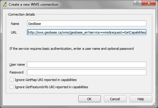
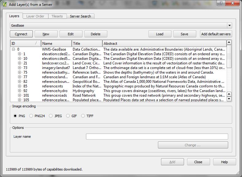
36 service=wms &request=getmap &version=1.1.1 &srs=epsg:4269 &bbox=-66.77,45.87,-66.57,46.01 &width=800&height=600 &style=&format=image/png &layers=nrn:roadnetwork
37 service=wms &request=getmap &version=1.1.1 &srs=epsg:4269 &bbox=-66.77,45.87,-66.57,46.01 &width=800&height=600 &style=&format=image/png &layers=nhn:hydrography,nrn:roadnetwork

38 service=wms &request=getmap &version=1.1.1 &srs=epsg:4269 &bbox=-66.77,45.87,-66.57,46.01 &width=800&height=600 &style=&format=image/png &layers=imagery:landsat7
39 service=wms &request=getmap &version=1.1.1 &srs=epsg:4269 &bbox=-180,-90,180,90 &width=800&height=600 &style=&format=image/png &layers=imagery:landsat7
40
41

42

43

44

45
46
47

48
49

50
51
52


53 ttp://ows.geobase.ca/wms/geobase_en? service=wms &request=getmap &version=1.1.1 &srs=epsg:4269 &bbox=-180,-90,180,90 &width=800&height=600 &style=&format=image/png &layers=imagery:landsat7

54

55

56
57 Interactive Maps Enriched functionality by extending the client side functionality the server side functionality GET CLIENT HTTP/HTML SERVER PUT 57
58 Extend both the Client and Server Example architecture Plugin/ JVM GET CGI CLIENT HTTP/HTML SERVER PUT 58
59 Extend both the Client and Server Google Earth (plugin) GET CLIENT HTTP SERVER PUT Google Earth CG I GoogleEarth Application HTML text Google Maps Database image 59
60 Extend both the Client and Server Java Virtual Machine GET CLIENT HTTP SERVER PUT ESRI ArcServer Java Applet Application HTML text Geo- Database image 60

61 Extend both the Client and Server 61
62 Extend both the Client and Server Java Virtual Machine GET CLIENT HTTP SERVER PUT UMN MapServer HTML text + JavaScripts Geo- Database image 62
 and Openlayers (JS)")
63 Extend both the Client and Server MapServer (CGI) and Openlayers (JS) 63


64 Involve a third party Mashups Map-Mashups 64
65 Involve a third party Mashups Alternative architectures Web-based mashups Combination of the content and formatting on the client side (web browser) Server-based mashups Combination of the content and formatting on the server 65
66 Server-based Mashups Java Virtual Machine GET CLIENT HTTP SERVER PUT UMN MapServer HTML text + JavaScripts Third Party (Google Server) Geo- Database image 66
67 Web-based Mashups Java Virtual Machine GET CLIENT HTTP SERVER PUT UMN MapServer HTML text + JavaScripts Third Party (Google Server) Geo- Database image 67

68 Map Mashups Base Map: Google Satellite Layers: Municipalities, Road Network, Buildings 68

69 Map Mashups Base Map: Google Map Layers: Municipalities, Road Network 69

70 Map Mashups 70

71 Map Mashups 71

72 Map Mashups 72
73 References ISO International Organization for Standardization, Kobben, B., Publishing maps on the Web. In Kraak and Brown, Kraak, J.M., and Brown A. (Eds) Web Cartography. CRC Pub. Mitchell, T., Web Mapping. O Reilly:USA. OGC Open Geospatial Consortium, OSGeo Open Source Geospatial Foundation, W3C World Wide Web Consortium, 73
Extending the Functionality of the Client
 Stefanakis, E., 2015. Web Mapping and Geospatial Web Services. CreateSpace Independent Publ. [In English], pp.168. Get a copy from Amazon Chapter 5 Extending the Functionality of the Client Emmanuel Stefanakis
Server-Side Graphics
 Server-Side Graphics SET09103 Advanced Web Technologies School of Computing Napier University, Edinburgh, UK Module Leader: Uta Priss 2008 Copyright Napier University Graphics Slide 1/16 Outline Graphics
X Slippy Maps. (...and Scott Davis)
") X Slippy Maps (...and Scott Davis) 1 2 Scott Davis 3 4 It was the best of times, it was the worst of times... 5 6 Ajax 7 Static Maps vs. Slippy Maps 8 9 10 Who is the OGC? The Open Geospatial Consortium
X Slippy Maps (...and Scott Davis) 1 2 Scott Davis 3 4 It was the best of times, it was the worst of times... 5 6 Ajax 7 Static Maps vs. Slippy Maps 8 9 10 Who is the OGC? The Open Geospatial Consortium
Interactive Web Mapping: Overview
 Interactive Web Mapping: Overview Overview of how geospatial data is formatted requested supplied consumed by/for web technologies 2 Definitions Analysis exploring and modeling geospatial phenomena Mapping
Lecture note on the history and principles of geo-webservices
 A SHORT INTRODUCTION TO GEO-WEBSERVICES Lecture note on the history and principles of geo-webservices Barend Köbben Version 1.0 February 24, 2010 Contents 1 From monolithic to distributed GIS architectures
HTML5 - SVG. SVG is mostly useful for vector type diagrams like Pie charts, Two-dimensional graphs in an X,Y coordinate system etc.
 http://www.tutorialspoint.com/html5/html5_svg.htm HTML5 - SVG Copyright tutorialspoint.com SVG stands for Scalable Vector Graphics and it is a language for describing 2D-graphics and graphical applications
Implementing Web GIS Solutions
 Implementing Web GIS Solutions using open source software Karsten Vennemann Seattle Talk Overview Talk Overview Why and What What is Open Source (GIS)? Why use it? Application Components Overview of Web
XML TECHNOLOGIES IN WEB BASED GEOGRAPHIC INFORMATION SYSTEMS
 212 Proceedings of the 4 th International Conference on Informatics and Information Technology XML TECHNOLOGIES IN WEB BASED GEOGRAPHIC INFORMATION SYSTEMS B. Predić, D. Stojanović Faculty of Electronic
CMPT 165 Graphics Part 2. Nov 3 rd, 2015
 CMPT 165 Graphics Part 2 Nov 3 rd, 2015 Key concepts of Unit 5-Part 1 Image resolution Pixel, bits and bytes Colour info (intensity) vs. coordinates Colour-depth Color Dithering Compression Transparency
Scalable Vector Graphics SVG
 LECTURE 7 Scalable Vector Graphics SVG CS 5513 Multimedia Systems Spring 2009 Imran Ihsan Principal Design Consultant OPUSVII www.opuseven.com Faculty of Engineering & Applied Sciences What is SVG? SVG
Leveraging OGC Services in ArcGIS Server. Satish Sankaran, Esri Yingqi Tang, Esri
 Leveraging OGC Services in ArcGIS Server Satish Sankaran, Esri Yingqi Tang, Esri GIS Creating and Managing Geo Information Products - Proprietary - Open Specifications - Standards Dissemination of Geo
This is the vector graphics "drawing" technology with its technical and creative beauty. SVG Inkscape vectors
 1 SVG This is the vector graphics "drawing" technology with its technical and creative beauty SVG Inkscape vectors SVG 2 SVG = Scalable Vector Graphics is an integrated standard for drawing Along with
Leveraging OGC Services in ArcGIS Server
 Esri International User Conference San Diego, CA Technical Workshops Jul.14 th 2011 Leveraging OGC Services in ArcGIS Server Satish Sankaran Yingqi Tang Agenda Interoperability
CMPS 179. UX for Designing 3D, Anima2on, and Interac2on for the Web. Name Professors: Here Reid Swanson & Matt Maclaurin
 CMPS 179 UX for Designing 3D, Anima2on, and Interac2on for the Web Name Professors: Here Reid Swanson & Matt Maclaurin TA: Title Peter Here Mawhorter (Arial) ARIAL CMPS NARROW 179: Today TITLE Wait list
Getting Started with the ArcGIS Server JavaScript API
 Getting Started with the ArcGIS Server JavaScript API Agenda Introduction ArcGIS Server services and mashups REST API Services Directory JavaScript API ArcGIS Server Resource Center Dojo Maps, layers,
USING SVG XML FOR REPRESENTATION OF HISTORICAL GRAPHICAL DATA
 Преглед НЦД 9 (2006), 39 45 Dušan Tošić, Vladimir Filipović, (Matematički fakultet, Beograd) Jozef Kratica (Matematički institut SANU, Beograd) USING SVG XML FOR REPRESENTATION OF HISTORICAL GRAPHICAL
Scalable Vector Graphics commonly known as SVG is a XML based format to draw vector images. It is used to draw twodimentional vector images.
 About the Tutorial Scalable Vector Graphics commonly known as SVG is a XML based format to draw vector images. It is used to draw twodimentional vector images. This tutorial will teach you basics of SVG.
Getting Started with ArcGIS for Server. Charmel Menzel and Ken Gorton
 Getting Started with ArcGIS for Server Charmel Menzel and Ken Gorton Agenda What is ArcGIS for Server? Types of Web services Publishing resources onto the Web Clients to ArcGIS for Server Editions and
CS474 MULTIMEDIA TECHNOLOGY
 CS474 MULTIMEDIA TECHNOLOGY Pr. G. Tziritas, Spring 2018 SVG Animation Tutorial G. Simantiris (TA) OVERVIEW Introduction Definitions SVG Creating SVGs SVG basics Examples Animation using software Examples
Developing a Free and Open Source Software based Spatial Data Infrastructure. Jeroen Ticheler
 Developing a Free and Open Source Software based Spatial Data Infrastructure Jeroen Ticheler 1 License This work is licensed under the Creative Commons Attribution-NonCommercial-ShareAlike 2.5 License.
City of Mobile GIS Web Mapping Applications: New Technology, New Expectations
 City of Mobile GIS Web Mapping Applications: New Technology, New Expectations Presenters : Scott Kearney GIS Manager Patricia Creamer GIS Analyst Background: GIS Department Developing web mapping apps
Create a cool image gallery using CSS visibility and positioning property
 GRC 275 A8 Create a cool image gallery using CSS visibility and positioning property 1. Create a cool image gallery, having thumbnails which when moused over display larger images 2. Gallery must provide
Providing Interoperability Using the Open GeoServices REST Specification
 2013 Esri International User Conference July 8 12, 2013 San Diego, California Technical Workshop Providing Interoperability Using the Open GeoServices REST Specification Satish Sankaran Kevin Sigwart What
Web Standards Mastering HTML5, CSS3, and XML
 Web Standards Mastering HTML5, CSS3, and XML Leslie F. Sikos, Ph.D. orders-ny@springer-sbm.com www.springeronline.com rights@apress.com www.apress.com www.apress.com/bulk-sales www.apress.com Contents
Open Standards for Web Standards in real world Electrical Plugs (and voltage!)
") Open Standards for Web Standards in real world Electrical Plugs (and voltage!) electronic devices need standardized access to electrical power. 1 Standards in real world Audio-Video cables are standardized
Open Standards for Web Standards in real world Electrical Plugs (and voltage!) electronic devices need standardized access to electrical power. 1 Standards in real world Audio-Video cables are standardized
Accessing OGC Services To access OGC WMS and WFS open the service in the directory that you want to consume, and click on either WMS or WFS.
 Using Web Services Web Services Overview This user guide contains instructions on how to consume a range of services through a range of both web based and desktop GIS applications. Web services are a live
HTML HTML. Chris Seddon CRS Enterprises Ltd 1
 Chris Seddon seddon-software@keme.co.uk 2000-12 CRS Enterprises Ltd 1 2000-12 CRS Enterprises Ltd 2 Reference Sites W3C W3C w3schools DevGuru Aptana GotAPI Dog http://www.w3.org/ http://www.w3schools.com
IT2353 WEB TECHNOLOGY Question Bank UNIT I 1. What is the difference between node and host? 2. What is the purpose of routers? 3. Define protocol. 4.
 IT2353 WEB TECHNOLOGY Question Bank UNIT I 1. What is the difference between node and host? 2. What is the purpose of routers? 3. Define protocol. 4. Why are the protocols layered? 5. Define encapsulation.
Building Mashups Using the ArcGIS APIs for FLEX and JavaScript. Shannon Brown Lee Bock
 Building Mashups Using the ArcGIS APIs for FLEX and JavaScript Shannon Brown Lee Bock Agenda Introduction Mashups State of the Web Client ArcGIS Javascript API ArcGIS API for FLEX What is a mashup? What
Client-side Web Engineering 2 From XML to Client-side Mashups. SWE 642, Spring 2008 Nick Duan. February 6, What is XML?
 Client-side Web Engineering 2 From XML to Client-side Mashups SWE 642, Spring 2008 Nick Duan February 6, 2008 1 What is XML? XML extensible Markup Language Definition: XML is a markup language for documents
USING SVG XML FOR REPRESENTATION OF HISTORICAL GRAPHICAL DATA
 Преглед НЦД 9 (2006), 39 45 Dušan Tošić, Vladimir Filipović, (Matematički fakultet, Beograd) Jozef Kratica (Matematički institut SANU, Beograd) USING SVG XML FOR REPRESENTATION OF HISTORICAL GRAPHICAL
Java Applets, etc. Instructor: Dmitri A. Gusev. Fall Lecture 25, December 5, CS 502: Computers and Communications Technology
 Java Applets, etc. Instructor: Dmitri A. Gusev Fall 2007 CS 502: Computers and Communications Technology Lecture 25, December 5, 2007 CGI (Common Gateway Interface) CGI is a standard for handling forms'
Open Geospatial Consortium (OGC) and Web Services (WMS, WFS)
 and Web Services (WMS, WFS)") Open Geospatial Consortium (OGC) and Web Services (WMS, WFS) Responsible persons: Regula Stopper (Overall) Ionut Iosifescu Enescu (Content) Samuel Wiesmann (Revision) Olaf Schnabel (Revision) Content
Open Geospatial Consortium (OGC) and Web Services (WMS, WFS) Responsible persons: Regula Stopper (Overall) Ionut Iosifescu Enescu (Content) Samuel Wiesmann (Revision) Olaf Schnabel (Revision) Content
HTML. Mohammed Alhessi M.Sc. Geomatics Engineering. Internet GIS Technologies كلية اآلداب - قسم الجغرافيا نظم المعلومات الجغرافية
 HTML Mohammed Alhessi M.Sc. Geomatics Engineering Wednesday, February 18, 2015 Eng. Mohammed Alhessi 1 W3Schools Main Reference: http://www.w3schools.com/ 2 What is HTML? HTML is a markup language for
Category: Informational August A Proposed Extension to HTML : Client-Side Image Maps
 Network Working Group J. Seidman Request for Comments: 1980 Spyglass, Inc. Category: Informational August 1996 A Proposed Extension to HTML : Client-Side Image Maps Status of this Memo This memo provides
Developing an Advanced Document Based Map Server *
 Proceedings of the 8 th International Conference on Applied Informatics Eger, Hungary, January 27 30, 2010. Vol. 1. pp. 337 344. Developing an Advanced Document Based Map Server * Roberto Giachetta a,
16. HTML5, HTML Graphics, & HTML Media 웹프로그래밍 2016 년 1 학기 충남대학교컴퓨터공학과
 16. HTML5, HTML Graphics, & HTML Media 웹프로그래밍 2016 년 1 학기 충남대학교컴퓨터공학과 목차 HTML5 Introduction HTML5 Browser Support HTML5 Semantic Elements HTML5 Canvas HTML5 SVG HTML5 Multimedia 2 HTML5 Introduction What
HTML5 and CSS3--Images Page 1
 HTML5 and CSS3--Images Page 1 1 HTML5 and CSS3 IMAGES 2 3 4 5 6 Images in HTML Since HTML is text, images are not inserted into the HTML document using the tag Different image types used on the Web:.jpg
Caching Tile Cache Creation & Management
 Exploring Options for Map Caching Tile Cache Creation & Management Presented By: Todd Wascher, Business Development Manager 04.21.2011 We Visualize Your World Whachutalkinbout? What we ll cover with this
County of Los Angeles. Chief Information Office Preferred Technologies for Geographic Information Systems (GIS) Version 2 May 2015
 Version 2 May 2015") County of Los Angeles Chief Information Office Preferred Technologies for Geographic Information Systems (GIS) Version 2 May 2015 CIO Preferred Technologies for GIS This document lists the preferred Geographic
County of Los Angeles Chief Information Office Preferred Technologies for Geographic Information Systems (GIS) Version 2 May 2015 CIO Preferred Technologies for GIS This document lists the preferred Geographic
Getting Started with the new GIS Map Service Overview:
 Getting Started with the new GIS Map Service Overview: 1. Layer List Widget Shows all available layers. This widget will be open by default. 2. Legend Widget Gives symbology information for all visible
tmap : a SVG Generator for Animated Maps
 : a SVG Generator for Animated Maps Laurent PIERRE EDF R&D laurent.pierre@edf.fr Presentation Electricité De France ( EDF) is the historical french electricity utility. EDF R&D (2000 ind) is a mutualized
IT430- E-COMMERCE Solved MCQ(S) From Midterm Papers (1 TO 22 Lectures) BY Arslan Arshad
 From Midterm Papers (1 TO 22 Lectures) BY Arslan Arshad") IT430- E-COMMERCE Solved MCQ(S) From Midterm Papers (1 TO 22 Lectures) BY Arslan Arshad OCT 21,2016 BS110401050 BS110401050@vu.edu.pk Arslan.arshad01@gmail.com AKMP01 IT430 - E-COMMERCE Midterm Papers
IT430- E-COMMERCE Solved MCQ(S) From Midterm Papers (1 TO 22 Lectures) BY Arslan Arshad OCT 21,2016 BS110401050 BS110401050@vu.edu.pk Arslan.arshad01@gmail.com AKMP01 IT430 - E-COMMERCE Midterm Papers
Implementation of Web Geoservices by National Cartographic Center *
 UNITED NATIONS E/CONF.100/IP.13 ECONOMIC AND SOCIAL COUNCIL Eighteenth United Nations Regional Cartographic Conference for Asia and the Pacific Bangkok, 26-29 October 2009 Item 7(b) of the provisional
16 th European Tcl/Tk User Meeting July, 7 th and 8 th 2017, Munich, Germany
 16 th European Tcl/Tk User Meeting July, 7 th and 8 th 2017, Munich, Germany http://rattlecad.sourceforge.net/ design your custom Bike Manfred Rosenberger cad4tcl a CAD package for Tcl rattlecad The Bicycle
Linking and Finding Earth Observation (EO) Data on the Web
 Data on the Web") Linking and Finding Earth Observation (EO) Data on the Web MACS-G20 Workshop: Linked Open Data in Agriculture Berlin, September 27-28, 2017 Dr. Uwe Voges u.voges@conterra.de Introduction Earth Observation
Linking and Finding Earth Observation (EO) Data on the Web MACS-G20 Workshop: Linked Open Data in Agriculture Berlin, September 27-28, 2017 Dr. Uwe Voges u.voges@conterra.de Introduction Earth Observation
Visual System Implementation
 Visual System Implementation Shamal AL-Dohuki and Ye Zhao Shamal AL-Dohuki Ph.D. candidate in the Department of Computer Science at Kent State University, Ohio, USA. Software Development Lead of TrajAnalytics
ERDAS Image Web Server Datasheet
 ERDAS Image Web Server Datasheet age 1 of 10 ERDAS Image Web Server Image serving protocols Multi-protocol support Expose images with different protocols. ERDAS Compressed Wavelet Protocol (ECWP) image
Oracle Spatial Users Conference
 April 2006 April 27, 2006 Tampa Convention Center Tampa, Florida, USA April 2006 Michael Smith Physical Scientist Remote Sensing/GIS Center of Expertise Army Corps of Engineers Engineer Research & Development
Etanova Enterprise Solutions
 Etanova Enterprise Solutions Front End Development» 2018-09-23 http://www.etanova.com/technologies/front-end-development Contents HTML 5... 6 Rich Internet Applications... 6 Web Browser Hardware Acceleration...
New Viewer Functionality PRINT FUNCTIONALITY
 HTML5 Viewer using Google Chrome This document provides information on using the new HTLM5 viewer with Google Chrome. Note that examples and screenshots in this document have been provided from the esearch
XML is a popular multi-language system, and XHTML depends on it. XML details languages
 1 XML XML is a popular multi-language system, and XHTML depends on it XML details languages XML 2 Many of the newer standards, including XHTML, are based on XML = Extensible Markup Language, so we will
HTML. Hypertext Markup Language. Code used to create web pages
 Chapter 4 Web 135 HTML Hypertext Markup Language Code used to create web pages HTML Tags Two angle brackets For example: calhoun High Tells web browser ho to display page contents Enter with
Implementing OGC Web Map Service Client Applications Using JSP, JSTL and XMLC
 Implementing OGC Web Map Service Client Applications Using JSP, JSTL and XMLC Hao Ding, Richard Pascoe & Neville Churcher Department of Computer Science University of Canterbury. Christchurch, New Zealand
Data Visualization (DSC 530/CIS )
") Data Visualization (DSC 530/CIS 602-01) HTML, CSS, & SVG Dr. David Koop Data Visualization What is it? How does it differ from computer graphics? What types of data can we visualize? What tasks can we
Data Visualization (DSC 530/CIS 602-01) HTML, CSS, & SVG Dr. David Koop Data Visualization What is it? How does it differ from computer graphics? What types of data can we visualize? What tasks can we
The course also includes an overview of some of the most popular frameworks that you will most likely encounter in your real work environments.
 Web Development WEB101: Web Development Fundamentals using HTML, CSS and JavaScript $2,495.00 5 Days Replay Class Recordings included with this course Upcoming Dates Course Description This 5-day instructor-led
Leveraging OGC Services in ArcGIS Server. Satish Sankaran Yingqi Tang
 Leveraging OGC Services in ArcGIS Server Satish Sankaran ssankaran@esri.com Yingqi Tang ytang@esri.com Agenda Interoperability Enablers OGC and esri OGC Web Services ArcGIS and OGC Web Services - @ version
Image Use and Manipulation with
 Image Use and Manipulation with PeopleTools Randall Groncki July 17, 2018 About Me Independent Consultant Northern VA, DC Area Tech since 1996 PeopleSoft (PSG), Hunter, Renaissance Employee: 7679 Safe
Contents. 1. Using Cherry 1.1 Getting started 1.2 Logging in
 1 Contents 1. Using Cherry 1.1 Getting started 1.2 Logging in 2. Site Page Hierarchy Management 2.1 Page Addition 2.2 Page Deletion 2.3 Editing Page Details 3. Page Content Modification 3.1 Page Revisions
When learning coding, be brave
 Who am I? Web Technology Overview with a focus on JavaScript-based technologies Lawrence Yao l.yao@unsw.edu.au Lawrence Yao UNSW casual staff Developer Analyst at YTML Consulting Email me if you need technical
3D webservices - where do we stand? Emmanuel Belo
 3D webservices - where do we stand? Emmanuel Belo +41 21 619 10 25 emmanuel.belo@camptocamp.com Camptocamp Open Source Service Provider Staff 49 Switzerland, France & Austria Since 2001 Wien Lausanne Chambéry
1/27/2013. Outline. Adding images to your site. Images and Objects INTRODUCTION TO WEB DEVELOPMENT AND HTML
 Outline INTRODUCTION TO WEB DEVELOPMENT AND HTML Images and Objects: Adding images to your site Adding Objects with Using Images as Links Image Maps Exercise Lecture 05 - Spring 2013 Adding images
OSGeo Web Mapping Typification: GeoMajas, Mapbender, MapFish and OpenLayers. Christoph Baudson Arnulf Christl FOSS4G 2010 Barcelona
 OSGeo Web Mapping Typification: GeoMajas, Mapbender, MapFish and OpenLayers Christoph Baudson Arnulf Christl FOSS4G 2010 Barcelona Disclaimer All information contained in this presentation has been compiled
From Synergie and Oppidum to Synopsis
 From Synergie and Oppidum to Synopsis M.-F. VOIDROT & A. LASSERRE-BIGORRY EGOWS Meeting ECMWF, June 2010 2 Overview Synergie and Oppidum : Two operational tools for forecasting at Meteo-France (and web
Chapter 10: Understanding the Standards
 Disclaimer: All words, pictures are adopted from Learning Web Design (3 rd eds.) by Jennifer Niederst Robbins, published by O Reilly 2007. Chapter 10: Understanding the Standards CSc2320 In this chapter
UR what? ! URI: Uniform Resource Identifier. " Uniquely identifies a data entity " Obeys a specific syntax " schemename:specificstuff
 CS314-29 Web Protocols URI, URN, URL Internationalisation Role of HTML and XML HTTP and HTTPS interacting via the Web UR what? URI: Uniform Resource Identifier Uniquely identifies a data entity Obeys a
Introduction THE OPENGEO ARCHITECTURE
 Introduction Putting maps on the web used to be very very difficult. It required specialized software, and more important, specialized knowledge about the kinds of data and processes used to create cartographic
Scalable Vector Graphics (SVG) vector image World Wide Web Consortium (W3C) defined with XML searched indexed scripted compressed Mozilla Firefox
 vector image World Wide Web Consortium (W3C) defined with XML searched indexed scripted compressed Mozilla Firefox") SVG SVG Scalable Vector Graphics (SVG) is an XML-based vector image format for twodimensional graphics with support for interactivity and animation. The SVG specification is an open standard developed
SVG SVG Scalable Vector Graphics (SVG) is an XML-based vector image format for twodimensional graphics with support for interactivity and animation. The SVG specification is an open standard developed
Mobile Viewers based on SVG ±geo and XFormsGI
 Mobile Viewers based on SVG ±geo and XFormsGI Thomas Brinkhoff 1, Jürgen Weitkämper 2 Institut für Angewandte Photogrammetrie und Geoinformatik (IAPG) Fachhochschule Oldenburg/Ostfriesland/Wilhelmshaven
CHAPTER 2 MARKUP LANGUAGES: XHTML 1.0
 WEB TECHNOLOGIES A COMPUTER SCIENCE PERSPECTIVE CHAPTER 2 MARKUP LANGUAGES: XHTML 1.0 Modified by Ahmed Sallam Based on original slides by Jeffrey C. Jackson reserved. 0-13-185603-0 HTML HELLO WORLD! Document
13. Databases on the Web
 13. Databases on the Web Requirements for Web-DBMS Integration The ability to access valuable corporate data in a secure manner Support for session and application-based authentication The ability to interface
Data Visualization (DSC 530/CIS )
") Data Visualization (DSC 530/CIS 60201) CSS, SVG, and JavaScript Dr. David Koop Definition of Visualization Computerbased visualization systems provide visual representations of datasets designed to help
Data Visualization (DSC 530/CIS 60201) CSS, SVG, and JavaScript Dr. David Koop Definition of Visualization Computerbased visualization systems provide visual representations of datasets designed to help
Web GIS: Principles and Applications. Pinde Fu, Ph.D. Project Lead / Senior Developer Professional Services Division
 Web GIS: Principles and Applications Pinde Fu, Ph.D. pfu@esri.com Project Lead / Senior Developer Professional Services Division 2 Web GIS: Principles and Applications Pinde Fu & Jiulin Sun Web GIS course
Background of HTML and the Internet
 Background of HTML and the Internet World Wide Web in Plain English http://www.youtube.com/watch?v=akvva2flkbk Structure of the World Wide Web A network is a structure linking computers together for the
A tutorial report for SENG Agent Based Software Engineering. Course Instructor: Dr. Behrouz H. Far. XML Tutorial.
 A tutorial report for SENG 609.22 Agent Based Software Engineering Course Instructor: Dr. Behrouz H. Far XML Tutorial Yanan Zhang Department of Electrical and Computer Engineering University of Calgary
Encoded URLs in hyperlinks. TerraGo Publisher for ArcGIS TerraGo Publisher for ArcGIS Server TerraGo Arc2Edge Version 7.3.
 TerraGo Publisher for ArcGIS TerraGo Publisher for ArcGIS Server TerraGo Arc2Edge Version 7.3.1, December 2017 What is TerraGo Publisher for ArcGIS? What is TerraGo Arc2Edge? What s new in this release?
Global Servers. The new masters
 Global Servers The new masters Course so far General OS principles processes, threads, memory management OS support for networking Protocol stacks TCP/IP, Novell Netware Socket programming RPC - (NFS),
Chapter 1 Getting Started with HTML 5 1. Chapter 2 Introduction to New Elements in HTML 5 21
 Table of Contents Chapter 1 Getting Started with HTML 5 1 Introduction to HTML 5... 2 New API... 2 New Structure... 3 New Markup Elements and Attributes... 3 New Form Elements and Attributes... 4 Geolocation...
Web Mapping Applications with ArcGIS. Bernie Szukalski Derek Law
 Web Mapping Applications with ArcGIS Bernie Szukalski Derek Law Agenda Web Mapping and Map Services Fundamentals ArcGIS Web Mapping Applications - Hosted online - Hosted on-premise Summary Web Application
Advanced Graphics Components Using JavaServer Faces Technology. Christophe Jolif Architect ILOG S.A.
 Advanced Graphics Components Using JavaServer Faces Technology Christophe Jolif Architect ILOG S.A. http://www.ilog.com Goal of the Session Learn how to build JavaServer Faces technology advanced graphics
Mapping, Visualization, and Digitization of the Geo-Referenced Information: A case study on Road Network Development in Near Real Time
 Mapping, Visualization, and Digitization of the Geo-Referenced Information: A case study on Road Network Development in Near Real Time Ronak Jain 1, Himansi Bhatt 2, Nithya Jeevanand 2, Praveen Kumar 3
Desktop. ArcGIS Server. ArcGIS
 Getting Started with ArcGIS Server Nakul Bhatia and David Crosby ESRI Charlotte 1 Agenda g Overview of ArcGIS Server 9.3.1 Working with GIS Services Using g Web GIS Service Clients ArcGIS Online Map Caching
Tutorial 1 Getting Started with HTML5. HTML, CSS, and Dynamic HTML 5 TH EDITION
 Tutorial 1 Getting Started with HTML5 HTML, CSS, and Dynamic HTML 5 TH EDITION Objectives Explore the history of the Internet, the Web, and HTML Compare the different versions of HTML Study the syntax
Fundamentals of Website Development
 Fundamentals of Website Development CSC 2320, Fall 2015 The Department of Computer Science In this chapter History of HTML HTML 5-2- 1 The birth of HTML HTML Blows and standardization -3- -4-2 HTML 4.0
Software Elements of Electronic Business Sites
 Software Elements of Electronic Business Sites Daniel A. Menascé, Ph. D. www.cs.gmu.edu/faculty/menasce.html 1 Implementation Options Client Server Client-side: client-side scripts Java applets Server-side:
Paths. "arc" (elliptical or circular arc), and. Paths are described using the following data attributes:
, and. Paths are described using the following data attributes:") Paths Paths are described using the following data attributes: "moveto" (set a new current point), "lineto" (draw a straight line), "arc" (elliptical or circular arc), and "closepath" (close the current
Paths Paths are described using the following data attributes: "moveto" (set a new current point), "lineto" (draw a straight line), "arc" (elliptical or circular arc), and "closepath" (close the current
SEXTANT 1. Purpose of the Application
 SEXTANT 1. Purpose of the Application Sextant has been used in the domains of Earth Observation and Environment by presenting its browsing and visualization capabilities using a number of link geospatial
Hot Desking Application Web Portals Integration
 Hot Desking Application Web Portals Integration NN10850-038 2 Document status: Standard Document issue: 04.01 Document date: Product release: Release 2.2 Job function: Fundamentals Type: NTP Language type:
State of the Open Web. Brad Neuberg, Google
 State of the Open Web Brad Neuberg, Google http://flickr.com/photos/jamespaullong/164875156/ Who is this guy? Ajax Image CC: jopemoro/flickr Who is this guy? Ajax Image CC: jopemoro/flickr Ajax Who is
PASS4TEST. IT Certification Guaranteed, The Easy Way! We offer free update service for one year
 PASS4TEST IT Certification Guaranteed, The Easy Way! \ http://www.pass4test.com We offer free update service for one year Exam : 9A0-046 Title : Adobe GoLive CS2 ACE Exam Vendors : Adobe Version : DEMO
HTML Overview. With an emphasis on XHTML
 HTML Overview With an emphasis on XHTML What is HTML? Stands for HyperText Markup Language A client-side technology (i.e. runs on a user s computer) HTML has a specific set of tags that allow: the structure
Design Project. i385f Special Topics in Information Architecture Instructor: Don Turnbull. Elias Tzoc
 Design Project Site: News from Latin America Design Project i385f Special Topics in Information Architecture Instructor: Don Turnbull Elias Tzoc April 3, 2007 Design Project - 1 I. Planning [ Upper case:
JavaScript By: A. Mousavi & P. Broomhead SERG, School of Engineering Design, Brunel University, UK
 Programming for Digital Media EE1707 JavaScript By: A. Mousavi & P. Broomhead SERG, School of Engineering Design, Brunel University, UK 1 References and Sources 1. Javascript & JQuery: interactive front-end
WebGIS exercise Land Change Viewer. Elisabeth Weinke Department of Geoinformatics University of Salzburg
 WebGIS exercise Land Change Viewer Elisabeth Weinke Department of Geoinformatics University of Salzburg Overview Client Application OpenLayers Google Maps Interface WMS WFS Server GeoServer Data management
Rob Weir, IBM 1 ODF and Web Mashups
 ODF and Web Mashups Basic techniques Rob Weir, IBM robert_weir@us.ibm.com 2009-11-05 1615 1 ODF and Web Mashups Agenda Why it is hard to use ODF in a web app Two techniques for accessing ODF on the web
BEST PRACTICES HTML5 SPECIFICATIONS. what's next in data-driven advertising. File Types. HTML5: HTML, JS, CSS, JPG, JPEG, GIF, PNG, and SVG
 SPECIFICATIONS HTML5 creatives are a type of display creative that must follow the same guidelines as display creatives with some additional recommendations. The IAB Display Advertising Guidelines (https://www.iab.com/newadportfolio/)
Setting Up and Deploying Geospatial Data Shares Using the QGIS Server Application
 Setting Up and Deploying Geospatial Data Shares Using the QGIS Server Application Donald L. Schrupp Wildlife Ecologist Colorado Division of Wildlife (retired) Quantum GIS (QGIS) Applications QGIS is not
Help Documentation. Copyright 2007 WebAssist.com Corporation All rights reserved.
 Help Documentation Copyright 2007 WebAssist.com Corporation All rights reserved. Using Pro Maps for Google This wizard adds a Pro Map for Google to your web page, allowing you to configure and specify
Interoperability and Standards Supports in ArcGIS
 Esri International User Conference San Diego, California Technical Workshops July 26, 2012 Interoperability and Standards Supports in ArcGIS Satish Sankaran, Esri Yingqi Tang, Esri Agenda Esri s participation
The Text Editor appears in many locations throughout Blackboard Learn and is used to format text. For example, you can use it to:
 About the Text Editor The Text Editor appears in many locations throughout Blackboard Learn and is used to format text. For example, you can use it to: Add items to Content Areas, Learning Modules, Lesson