Service metadata validation in Spatineo Monitor
|
|
|
- George Bailey
- 5 years ago
- Views:
Transcription

1 Service metadata validation in Spatineo Monitor Ilkka Rinne Spatineo Inc. INSPIRE MIG validation workshop JRC/Ispra, 15th & 16th May 2014 Spatineo Linnankoskenkatu 16 A 17 FI Helsinki Copyright Spatineo
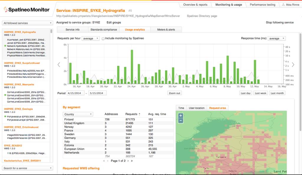
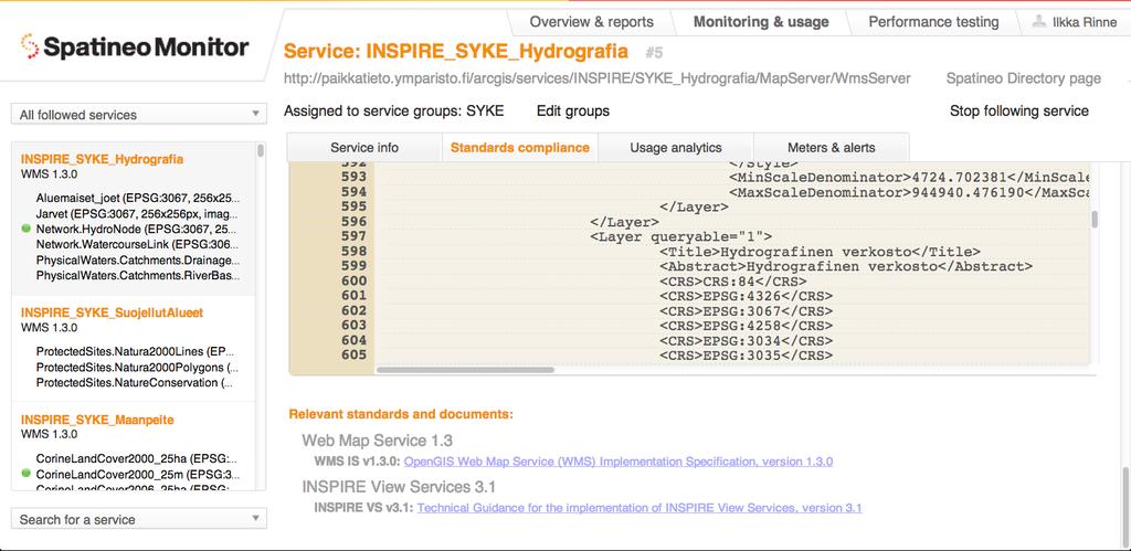
2 Continuous availability monitoring for Spatial Web Services including alerting capabilities. Interactive visual tools for analyzing the Quality of Service of Spatial Web Services and their usage by user segments, data set, area of interest etc. Graphical and spreadsheet reports for trends in usage by service, data set, user country etc. Maintenance break planning and announcement for the service user community. Service metadata validation. Copyright Spatineo
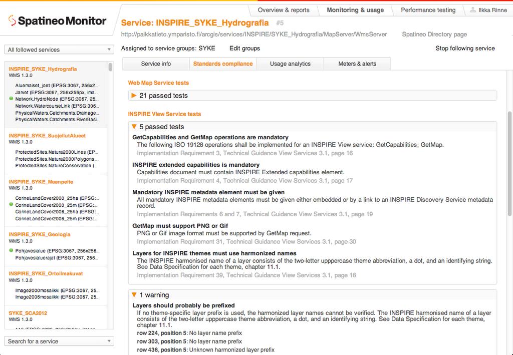
3 Motivation for validation in Spatineo Monitor Provide and easy way for the data providers to check that they have configured their service instance correctly to serve the compliant service metadata. Not intended for validating the full metadata records for the service or the provided data sets for INSPIRE conformance. Not intended to be used for testing server products against the OGC specification compliance. Copyright Spatineo
4
5
6
7
8
9
10

11
12
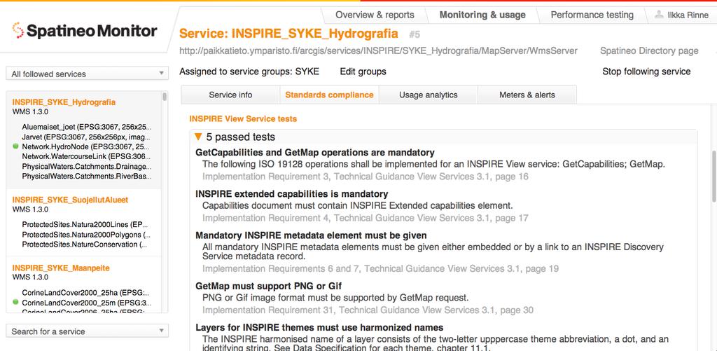
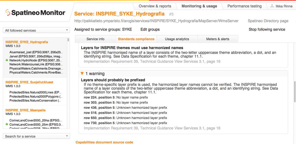
13 Currently supported validation targets OGC Web Map Service 1.3 OGC Web Map Tile Service 1.0 INSPIRE View Services profile of ISO 19128:2005 (WMS 1.3) INSPIRE View Services profile of WMTS (incomplete) Copyright Spatineo
14 Validator implementation Java code based on Apache XMLBeans: XML Schema -based validation Tests for the for specification s requirements coded directly in Java by pedantically following the specification / guideline texts. Test code is closed source code at the moment, but we d be delighted to move into using a reliable commonly agreed validator service. We ll continue to use our own UI integrated with the Spatineo Monitor requirement for a validator API. Copyright Spatineo
15 Current validator limitations Only validates the Capabilities files, not the referred external metadata. Does not test other operations than GetCapabilities (but the availability, capacity and performance are covered by other functionalities / products) No validation support for WFS Download Services. No validation support for Atom Download Services Copyright Spatineo
16 Development plans Spatineo validator development has been mostly on hold for the last year or so, partly because of on-going discussion about the common INSPIRE validator. The tool has been acclaimed by our customers, but we don t really want to duplicate code for the test suites: We d rather re-use the OGC CITE tests and contribute to the INSPIRE reference implementation provided that we can integrate it to the current application as a service. Copyright Spatineo
17 Our workshop in the INSPIRE Conference Practical quality assurance of spatial web services Topic: Evaluating and improving the quality-of-service (QoS) level of the spatial web services as experienced the the end-users. Participants learn about the QoS requirements specified of the INSPIRE Technical Guidance documents for View and Download Services, and are engages in practical discussion on finding the best methods methods for evaluating all the three of the INSPIRE service QoS aspects: availability, performance and capacity. Learn how to use top-of-the-line existing software tools for evaluating WMS, WFS and WMTS availability, capacity and performance, and have a possibility to setup and run short online performance tests against their own spatial web services. Learn what the Spatineo Monitor and the new Spatineo Performance tools can offer for the data providers. Tuesday, June 17th 09:00-12:00 Badstuestræde 9/auditorium 1 Copyright Spatineo
Extension of INSPIRE Download Services TG for Observation Data
 Extension of INSPIRE Download Services TG for Observation Data Simon Jirka (52 North) 14 th June 2014, MIG Workshop on WCS-based INSPIRE Download Services Agenda Motivation Sensor Web Proposed Update for
GML Application Schema for Meteorological Objects
 GML Application Schema for Meteorological Objects Ilkka Rinne Finnish Meteorological Institute 9 th June 2009, EGOWS meeting, De Bilt, Netherlands Prepare for INSPIRE, Learn OGC Web Services OGC Web Service
INSPIRE tools What's new?
 INSPIRE tools What's new? Michael Lutz INSPIRE Conference, Antwerp 18 September 2018 Joint Research Centre The European Commission s science and knowledge service INSPIRE reference validator Why a reference
Validating services and data in an SDI
 Validating services and data in an SDI Presentation to: By: Date: INSPIRE Conference Clemens Portele, Jon Herrmann, Roy Mellum 30 September 2016 4 October, 2016 ELF is the response from the European Mapping
Validation in the Netherlands and European Location Framework
 Validation in the Netherlands and European Location Framework INSPIRE Workshop on validation and conformity testing 15 16 May 2014 Thijs Brentjens Contents Geonovum and ELF INSPIRE INSPIRE in the Netherlands
Web Coverage Services (WCS)
") Web Coverage Services (WCS) www.jrc.ec.europa.eu Thematic Cluster #3 Jordi Escriu Facilitator Thematic Cluster #3 Serving society Stimulating innovation Supporting legislation Coverages in INSPIRE Coverage:
Web Coverage Services (WCS) www.jrc.ec.europa.eu Thematic Cluster #3 Jordi Escriu Facilitator Thematic Cluster #3 Serving society Stimulating innovation Supporting legislation Coverages in INSPIRE Coverage:
Proposed update of Technical Guidance for INSPIRE Download services based on SOS
 Proposed update of Technical Guidance for INSPIRE Download services based on SOS Organised by: Simon Jirka, Alexander Kotsev, Michael Lutz Dr. Simon Jirka (jirka@52north.org) 52 North GmbH Workshop - The
INSPIRE Download Service
 The OGC SOS as INSPIRE Download Service for (meteorological) l) Observation Data Simon Jirka (52 North) 29 th October 2014 5th Workshop on the use of GIS/OGC standards in meteorology Offenbach (Germany)
Standards, standardisation & INSPIRE Status, issues, opportunities
 Standards, standardisation & INSPIRE Status, issues, opportunities INSPIRE Coordination Team 6 th MIG meeting, 13-14 June 2017 Joint Research Centre The European Commission's science and knowledge service
Spatial Data on the Web
 Spatial Data on the Web Tools and guidance for data providers The European Commission s science and knowledge service W3C Data on the Web Best Practices 35 W3C/OGC Spatial Data on the Web Best Practices
European Location Framework (ELF) acting as a facilitator implementing INSPIRE
 acting as a facilitator implementing INSPIRE") www.eurogeographics.org European Location Framework (ELF) acting as a facilitator implementing INSPIRE Saulius Urbanas, Mick Cory (EuroGeographics) 29 October 2016 Copyright 2013 EuroGeographics EuroGeographics
www.eurogeographics.org European Location Framework (ELF) acting as a facilitator implementing INSPIRE Saulius Urbanas, Mick Cory (EuroGeographics) 29 October 2016 Copyright 2013 EuroGeographics EuroGeographics
Using the OGC SOS as INSPIRE Download Service for Observation Data
 Using the OGC SOS as INSPIRE Download Service for Observation Data Simon Jirka (52 North) Alexander Kotsev (JRC) Michael Lutz (JRC) Matthes Rieke (52 North) Robin Smith (JRC) Paul Smits (JRC) 18 th June
INSPIRE Download Services of the CNIG (Spain) Emilio López Romero
 Emilio López Romero") INSPIRE Download Services of the CNIG (Spain) Emilio López Romero 1 The beginning One day, few years ago, we decided to implement INSPIRE seriously 2 The sources The first step was to identify the available
INSPIRE Download Services of the CNIG (Spain) Emilio López Romero 1 The beginning One day, few years ago, we decided to implement INSPIRE seriously 2 The sources The first step was to identify the available
Leveraging OGC Services in ArcGIS Server. Satish Sankaran, Esri Yingqi Tang, Esri
 Leveraging OGC Services in ArcGIS Server Satish Sankaran, Esri Yingqi Tang, Esri GIS Creating and Managing Geo Information Products - Proprietary - Open Specifications - Standards Dissemination of Geo
Testing - an essential aspect of establishing an SDI
 Testing - an essential aspect of establishing an SDI Clemens Portele, Anders Östman, Michael Koutroumpas, Xin He, Janne Kovanen, Markus Schneider, Andriani Skopeliti INSPIRE Conference 2011 30 June 2011
Suggestions for writing Abstract Test Suites (ATS) for INSPIRE conformance testing for Metadata and Network Services
 for INSPIRE conformance testing for Metadata and Network Services") Suggestions for writing Abstract Test Suites (ATS) for INSPIRE conformance testing for Metadata and Network Services MIWP-5 Workshop 02. December 2014 Sven Böhme, Federal Agency for Cartography and Geodesy
Suggestions for writing Abstract Test Suites (ATS) for INSPIRE conformance testing for Metadata and Network Services MIWP-5 Workshop 02. December 2014 Sven Böhme, Federal Agency for Cartography and Geodesy
Validation experience
 Validation experience Paloma Abad Head of SDI Department SDI Workshop 26-06-2018 INSPIRE KEN INSPIRE KEN, june 2018 1 Points 1. Introduction 2. Interoperability 3. Geoportal Thematic Viewer 4. Conclusions
The French Geoportal : linking discovery and view network services. INSPIRE Conference Krakow
 The French Geoportal : linking discovery and view network services ( BRGM ) D.Richard (IGN) F. Robida Context of the French Geoportal The governance mechanism Transversal organisation based on the Ministry
This document is a preview generated by EVS
 TECHNICAL REPORT RAPPORT TECHNIQUE TECHNISCHER BERICHT CEN/TR 15449-5 April 2015 ICS 07.040; 35.240.70 English Version Geographic information - Spatial data infrastructures - Part 5: Validation and testing
Closing the INSPIRE Implementation Gap by Contributing to SDI Technology Development
 Closing the INSPIRE Implementation Gap by Contributing to SDI Technology Development Experiences from the Envibase project Lena Hallin-Pihlatie, Riikka Repo, Suvi Hatunen, Ilkka Rinne Finnish Environment
Metadata allows. Metadata Existing Guidelines. Data to be found Starts interoperability. Decision making based on Quality Relevance Time Geography
 Metadata Existing Guidelines ADQ AIXM Workshop 10 December 2013 Eduard Porosnicu EUROCONTROL DSR/CMN/IM Metadata allows Data to be found Starts interoperability Decision making based on Quality Relevance
ArcGIS Server: publishing geospatial data to the web using the EEA infrastructure
 ArcGIS Server: publishing geospatial data to the web using the EEA infrastructure *IMPORTANT: Map Services should be published using the EEA Map Services Tick Sheet for guidance. Contact Sebastien Petit
ICT Roadmap and ICT 1(6,6DQG6(,6%$6,6ZRUNVKRS DWWKH,163,5(&RQIHUHQFH.UDNRZ -DDQXV+HLQODLG 7LHWR(VWRQLD$6
 ICT Roadmap and ICT Guidelines DWWKH,163,5(&RQIHUHQFH.UDNRZ -DDQXV+HLQODLG 7LHWR(VWRQLD$6 Overall status Both ICT Roadmap and ICT Guidelines have changed extensively since the previous NESIS-BASIS workshop.
Metadata of geographic information
 Metadata of geographic information Kai Koistinen Management of environmental data and information 4.10.2017 Topics Metadata of geographic information What is metadata? Metadata standards and recommendations
Leveraging OGC Services in ArcGIS Server. Satish Sankaran Yingqi Tang
 Leveraging OGC Services in ArcGIS Server Satish Sankaran ssankaran@esri.com Yingqi Tang ytang@esri.com Agenda Interoperability Enablers OGC and esri OGC Web Services ArcGIS and OGC Web Services - @ version
Achieving Interoperability using the ArcGIS Platform. Satish Sankaran Roberto Lucchi
 Achieving Interoperability using the ArcGIS Platform Satish Sankaran Roberto Lucchi Thank you Please fill out the session survey in your mobile app Select [Achieving Interoperability using the ArcGIS Platform]
The coastal data in the regional and national territorial data repertory. Genova 24 Aprile 2012 Anna Cerrato Regione Liguria
 The coastal data in the regional and national territorial data repertory Genova 24 Aprile 2012 Anna Cerrato Regione Liguria www.rndt.gov.it Experience from data providers in using transformation tools
INSPIRE: The ESRI Vision. Tina Hahn, GIS Consultant, ESRI(UK) Miguel Paredes, GIS Consultant, ESRI(UK)
 Miguel Paredes, GIS Consultant, ESRI(UK)") INSPIRE: The ESRI Vision Tina Hahn, GIS Consultant, ESRI(UK) Miguel Paredes, GIS Consultant, ESRI(UK) Overview Who are we? Introduction to ESRI Inc. and ESRI(UK) Presenters ArcGIS The ESRI Solution to
INSPIRE: The ESRI Vision Tina Hahn, GIS Consultant, ESRI(UK) Miguel Paredes, GIS Consultant, ESRI(UK) Overview Who are we? Introduction to ESRI Inc. and ESRI(UK) Presenters ArcGIS The ESRI Solution to
Understanding and Using Metadata in ArcGIS. Adam Martin Marten Hogeweg Aleta Vienneau
 Understanding and Using Metadata in ArcGIS Adam Martin Marten Hogeweg Aleta Vienneau Adam Martin National Government Account Management R&D Open Data Marten Hogeweg National Government Professional Services
ELF download services
 ELF download services Presentation to: Author: Date: ELF workshop in Moldova Marcin Grudzień 8 h September2015 14 September, 2015 Plan Introduction Specification documents The envisaged production process
Esri Support for Geospatial Standards
 APRIL 2017 ArcGIS Is Open and Interoperable Esri Support for Geospatial Standards Copyright 2017 Esri All rights reserved. Printed in the United States of America. The information contained in this document
Initial Operating Capability & The INSPIRE Community Geoportal
 INSPIRE Conference, Rotterdam, 15 19 June 2009 1 Infrastructure for Spatial Information in the European Community Initial Operating Capability & The INSPIRE Community Geoportal EC INSPIRE GEOPORTAL TEAM
Dealing with INSPIRE complexity MIG proposal on alternative encodings
 Dealing with INSPIRE complexity MIG proposal on alternative encodings Nathalie Delattre (NGI Belgium), INSPIRE KEN Workshop, Warsaw 27-28 November 2018 Agenda 1. Basics 2. Rationales 3. MIG action 2017.2:
News in Download services in the Czech Republic. Petr Souček Czech Office for Surveying, Mapping and Cadastre Prague, Czech Republic
 News in Download services in the Czech Republic Petr Souček Czech Office for Surveying, Mapping and Cadastre Prague, Czech Republic Topics The infrastructure The experience with themes Parcels (CP), Addresses
From the INSPIRE Engine Room
 From the INSPIRE Engine Room Michael Lutz ENiiG Conference, Lisbon 9 November 2016 Joint Research Centre the European Commission's in-house science service The JRC's role in INSPIRE Support MS in implementation
Achieving Interoperability Using Open Standards
 FedGIS Conference February 24 25, 2016 Washington, DC Achieving Interoperability Using Open Standards Satish Sankaran Marten Hogeweg Agenda Understanding Interoperability What, Why and How? ArcGIS Platform
INSPIRE Conference Automatic metadata generation for the Web geo-resources
 INSPIRE Conference 2011 Automatic metadata generation for the Web geo-resources B. Borjas, A.J. Florczyk, F.J. López-Pellicer, J. Nogueras-Iso, F.J. Zarazaga-Soria June 28, 2011. Edinburgh Advanced Information
SEIS. (Shared Environmental Information System) From concept to information services
 From concept to information services") SEIS (Shared Environmental Information System) From concept to information services Stefan Jensen EEA supported by Sheila Cryan and Jon Maidens GSDI 11, Rotterdam 19.6.2009 What is SEIS is about... Sharing
SEIS (Shared Environmental Information System) From concept to information services Stefan Jensen EEA supported by Sheila Cryan and Jon Maidens GSDI 11, Rotterdam 19.6.2009 What is SEIS is about... Sharing
Basic Principles of MedWIS - WISE interoperability
 Co-ordination committee seminar of the national focal points Basic Principles of MedWIS - WISE interoperability Eduardo García ADASA Sistemas Nice - France Agenda WISE vs MedWIS WISE WISE DS WISE vs WISE
GeoDCAT-AP Representing geographic metadata by using the "DCAT application profile for data portals in Europe"
 GeoDCAT-AP Representing geographic metadata by using the "DCAT application profile for data portals in Europe" Andrea Perego, Vlado Cetl, Anders Friis-Christensen, Michael Lutz, Lorena Hernandez Joint
Introduction to INSPIRE. Network Services
 Introduction to INSPIRE. Network Services European Commission Joint Research Centre Institute for Environment and Sustainability Digital Earth and Reference Data Unit www.jrc.ec.europa.eu Serving society
Web Services Made Easy Without Any Coding. September 23, 2013
 Web Services Made Easy Without Any Coding September 23, 2013 Agenda Introduction Safe Software and FME FME Approach to Web Services Live Demos Consuming Web Services Leveraging Web Services Publishing
MetOcean Themes in INSPIRE
 MetOcean Themes in INSPIRE Cliquez pour modifier le style du titre 4th Workshop on the use of GIS/OGC standards in meteorology Cliquez pour modifier le style des sous-titres Frédéric du Guillaud masque
DATA VALIDATION AGAINST SCHEMA AND SOURCE DATA
 DATA VALIDATION AGAINST SCHEMA AND SOURCE DATA didier.bouteloup@ign.fr; dominique.laurent@ign.fr 3 June 2016 ign.fr Context IGN has performed data validation twice On test INSPIRE data (2013-2014) On ELF
INSPIRE Spatial Data on the Web building a user-friendly webby SDI
 INSPIRE Spatial Data on the Web building a user-friendly webby SDI Linda van den Brink & Friso Penninga (presented by Rob van de Velde) Geonovum Agenda Objective of this presentation: Apply insights from
Automatic Creation of INSPIRE Meta-information from SWE Services
 S@NY Automatic Creation of INSPIRE Meta-information from SWE Services Désirée Hilbring, Fraunhofer IITB hilbring@iitb.fraunhofer.de Agile 2009 Challenges in Geospatial Data Harmonization, Hanover Copyright
DanubeGIS User Manual Document number: Version: 1 Date: 11-Nov-2016
 DanubeGIS User Manual Document number: Version: 1 Date: 11-Nov-2016 Imprint Published by: ICPDR International Commission for the Protection of the Danube River ICPDR 2016 Contact ICPDR Secretariat Vienna
LPIS Workshop Applications and Quality
 2009 MARS Conference, 18-20 th November, 2009, Taormina 1 LPIS Workshop Applications and Quality 6-8 th October, Tallinn, Estonia Wim Devos, Valentina Sagris & Pavel Milenov EC Joint Research Centre Institute
1 Introduction. 2 National Data Exchange Layer
 Spatial Services in the egovernment: Delivering WFS and WMS Queries through the Data Exchange Layer of the Finnish National Architecture for Digital Services Pekka Latvala, Lassi Lehto Finnish Geospatial
verapdf Industry supported PDF/A validation
 verapdf Industry supported PDF/A validation About this webinar What we ll be showing you: our current development status; the Consortium s development plans for 2016; how we ve been testing the software
The UK Marine Environmental Data and Information Network MEDIN
 The UK Marine Environmental Data and Information Network MEDIN M. Charlesworth, R. Lowry, H. Freeman, J. Rapaport, B Seeley Content MEDIN - a brief overview for context Discovery Metadata Standard and
AQD IPR pilot study programme on e-reporting
 AQD IPR pilot study programme on e-reporting A quick start guide working with the e-reporting schemata Tony Bush 4 th pilot meeting Copenhagen 15-16 March 2012 Introduction What to worry about first if
ECP-2007-GEO OneGeology-Europe. Annex 1: Cookbook
 ECP-2007-GEO-317001 OneGeology-Europe Annex 1: Cookbook for creating multilingual metadata records using the OneGeology-Europe Metadata system (MIcKA) Authors: Lucie Kondrová, Robert Tomas, Štěpán Kafka
Interoperability and Standards Supports in ArcGIS
 Esri International User Conference San Diego, California Technical Workshops July 26, 2012 Interoperability and Standards Supports in ArcGIS Satish Sankaran, Esri Yingqi Tang, Esri Agenda Esri s participation
pgrouting extends the postgis/postgresql geospatial database to provide geospatial routing and other network analysis functionality.
 Workshop: 1 pgrouting extends the postgis/postgresql geospatial database to provide geospatial routing and other network analysis functionality. Attendee s previous knowledge: SQL (PostgreSQL, PostGIS)
Metadata for Data Discovery: The NERC Data Catalogue Service. Steve Donegan
 Metadata for Data Discovery: The NERC Data Catalogue Service Steve Donegan Introduction NERC, Science and Data Centres NERC Discovery Metadata The Data Catalogue Service NERC Data Services Case study:
Christian Ansorge 27th April CDDA webinar 27th April Linked Approach as reporting mechanism
 Christian Ansorge 27th April 2017 CDDA webinar 27th April 2017 Linked Approach as reporting mechanism Generic Linked Approach Scope Background and motivation for reporting reusing INSPIRE Introduction
Welcome to today s Webcast. Thank you so much for joining us today!
 Welcome to today s Webcast. Thank you so much for joining us today! My name is Michael Costa. I m a member of the DART Team, one of several groups engaged by HAB to provide training and technical assistance
ISA Action 1.17: A Reusable INSPIRE Reference Platform (ARE3NA)
") ISA Action 1.17: A Reusable INSPIRE Reference Platform (ARE3NA) Expert contract supporting the Study on RDF and PIDs for INSPIRE Deliverable D.EC.3.2 RDF in INSPIRE Open issues, tools, and implications
ISA Action 1.17: A Reusable INSPIRE Reference Platform (ARE3NA) Expert contract supporting the Study on RDF and PIDs for INSPIRE Deliverable D.EC.3.2 RDF in INSPIRE Open issues, tools, and implications
The European Commission s science and knowledge service. Joint Research Centre
 The European Commission s science and knowledge service Joint Research Centre GeoDCAT-AP The story so far Andrea Perego, Antonio Rotundo, Lieven Raes GeoDCAT-AP Webinar 6 June 2018 What is GeoDCAT-AP Geospatial
Implementing GeoDRM support in an OpenLayers based viewer Access to the French geoportal WMS-C services from the Spanish SDI
 INSPIRE Conference 2011 Implementing GeoDRM support in an OpenLayers based viewer Access to the French geoportal WMS-C services from the Spanish SDI R. Béjar, M. Á. Latre, J. Valiño, F. Javier Zarazaga-Soria,
Serving Large-Scale Coverages - How to Tame an Elephant
 Serving Large-Scale s - How to Tame an Elephant OGC Workshop 2 INSPIRE Conference Edinburgh, 29-jun-2011 Peter Baumann Jacobs University rasdaman GmbH OGC WCS.SWG chair OGC spec editor Sensor & Image Data
SII Law Organization Coordination activities Examples of good practices Education Technical matters Success stories Challenges
 SII Law Organization Coordination activities Examples of good practices Education Technical matters Success stories Challenges INSPIRE transposed by the legal act on Spatial Information Infrastructure
(Geo)DCAT-AP Status, Usage, Implementation Guidelines, Extensions
DCAT-AP Status, Usage, Implementation Guidelines, Extensions") (Geo)DCAT-AP Status, Usage, Implementation Guidelines, Extensions HMA-AWG Meeting ESRIN (Room D) 20. May 2016 Uwe Voges (con terra GmbH) GeoDCAT-AP European Data Portal European Data Portal (EDP): central
(Geo)DCAT-AP Status, Usage, Implementation Guidelines, Extensions HMA-AWG Meeting ESRIN (Room D) 20. May 2016 Uwe Voges (con terra GmbH) GeoDCAT-AP European Data Portal European Data Portal (EDP): central
Quality control service for Inspire data
 Quality control service for Inspire data INSPIRE Conference 2014 Aalborg Anders Foureaux Process Manager Data feeds Data hosting Environmental Informations Systems Unit Reasearch and Assessment Department
e SOTER Informatics Framework Key lessons learnt
 Workshop to develop 250,000 soil database for Danube Basin using e SOTER methodology JRC, Ispra, Italy, 5 6/Feb/2015 e SOTER Informatics Framework Key lessons learnt Dr Stephen Hallett Cranfield University,
Interoperability with ArcGIS
 Interoperability with ArcGIS Satish Sankaran Marten Hogeweg Agenda Understanding Interoperability What, Why and How? ArcGIS Platform An Open Platform Supporting Interoperability Examples from the real
INSPIRE roadmap and architecture: lessons learned INSPIRE 2017
 INSPIRE roadmap and architecture: lessons learned INSPIRE 2017 Stijn Goedertier GIM Thierry Meessen GIM Jeff Konnen ACT Luxembourg Patrick Weber ACT Luxembourg 1 Administration du cadastre et de la topographie
Consolidation Team INSPIRE Annex I data specifications testing Call for Participation
 INSPIRE Infrastructure for Spatial Information in Europe Technical documents Consolidation Team INSPIRE Annex I data specifications testing Call for Participation Title INSPIRE Annex I data specifications
Welcome to the Introduction to Mapbender
 0 Welcome to the Introduction to Mapbender Author: Astrid Emde Author: Christoph Baudson Version: 1.0 License: Creative Commons Date: 2010-08-30 1 Table of Contents 1 Project Overview 2 1.1 Geoportal Framework
Umweltbundesamt. Masaryk University Laboratory on Geoinformatics and Cartography
 Co-funded by the community programme econtentplus GS SOIL METADATA Christian Ansorge Umweltbundesamt Tomáš Řezník Masaryk University Laboratory on Geoinformatics and Cartography GS Soil workshop, INSPIRE
Linking and Finding Earth Observation (EO) Data on the Web
 Data on the Web") Linking and Finding Earth Observation (EO) Data on the Web MACS-G20 Workshop: Linked Open Data in Agriculture Berlin, September 27-28, 2017 Dr. Uwe Voges u.voges@conterra.de Introduction Earth Observation
Linking and Finding Earth Observation (EO) Data on the Web MACS-G20 Workshop: Linked Open Data in Agriculture Berlin, September 27-28, 2017 Dr. Uwe Voges u.voges@conterra.de Introduction Earth Observation
Notes for: Experiences with implementing interoperable WFS 2.0 services
 Notes for: Experiences with implementing interoperable WFS 2.0 services @Linking Geospatial Data 5-6 th March 2014 W3C,OGC Google Campus London Dr Tim Duffy trd@bgs.ac.uk Open source software issues Open
OGC Compliance Infrastructure
 OGC Compliance Infrastructure INSPIRE workshop on validation and conformity Ispra, Italy May 16, 2014 Luis Bermudez, Sebastian Goerke 10 Years providing compliance 300+ Copyright 2014 Open Geospatial Consortium
Data Quality Assessment Tool for health and social care. October 2018
 Data Quality Assessment Tool for health and social care October 2018 Introduction This interactive data quality assessment tool has been developed to meet the needs of a broad range of health and social
How to become an INSPIRE node and fully exploit the investments made?
 How to become an INSPIRE node and fully exploit the investments made? Solution patterns for consumers: end users & developers (2/2) Roberto Lucchi 22 June 2010, Krakow 1 Geoportal extension Enabling discovery
From Geoportal to Spatial Data Service Platform. Jani Kylmäaho National Land Survey of Finland Development Centre
 From Geoportal to Spatial Data Service Platform Jani Kylmäaho National Land Survey of Finland Development Centre Introduction National Land Survey of Finland - 1900 employees Development Centre - 120 employees
The Spatial Data Standards for Facilities, Infrastructure and Environment (SDSFIE) Quality and Raster Standards
 Quality and Raster Standards") The Spatial Data Standards for Facilities, Infrastructure and Environment (SDSFIE) Quality and Raster Standards Ms. Karen Barnhouse DISDI Program Support OASD(EI&E) June 29, 2016 Agenda What is the SDSFIE
The Spatial Data Standards for Facilities, Infrastructure and Environment (SDSFIE) Quality and Raster Standards Ms. Karen Barnhouse DISDI Program Support OASD(EI&E) June 29, 2016 Agenda What is the SDSFIE
Incremental Update in Web Service Environment Case: Use of the OGC s GeoSynchronization Service to Integrate Hydrographic Datasets
 Incremental Update in Web Service Environment Case: Use of the OGC s GeoSynchronization Service to Integrate Hydrographic Datasets Pekka Latvala, Eero Hietanen Finnish Geospatial Research Institute (FGI),
Understanding and Working with the OGC Geopackage. Keith Ryden Lance Shipman
 Understanding and Working with the OGC Geopackage Keith Ryden Lance Shipman Introduction - Introduction to Simple Features - What is the GeoPackage? - Esri Support - Looking ahead Geographic Things 3 Why
The Scottish Spatial Data Infrastructure (SSDI)
") The Scottish Spatial Data Infrastructure (SSDI) INSPIRE Conference Istanbul Monday 25 th June 2012 15:55 Geoportals and registries II Tim Duffy BGS Edinburgh (trd@bgs.ac.uk) Shona Nicol Alex Ramage NERC
The Scottish Spatial Data Infrastructure (SSDI) INSPIRE Conference Istanbul Monday 25 th June 2012 15:55 Geoportals and registries II Tim Duffy BGS Edinburgh (trd@bgs.ac.uk) Shona Nicol Alex Ramage NERC
EXERCISE: Publishing spatial data with GeoServer
 EXERCISE: Publishing spatial data with GeoServer Barend Köbben Ivana Ivánová August 30, 2015 Contents 1 Introduction 2 2 GeoServer s main concepts 2 3 Publishing spatial dataset to the GeoServer 5 3.1
Developing a Free and Open Source Software based Spatial Data Infrastructure. Jeroen Ticheler
 Developing a Free and Open Source Software based Spatial Data Infrastructure Jeroen Ticheler 1 License This work is licensed under the Creative Commons Attribution-NonCommercial-ShareAlike 2.5 License.
SAS Web Infrastructure Kit 1.0. Overview
 SAS Web Infrastructure Kit 1.0 Overview The correct bibliographic citation for this manual is as follows: SAS Institute Inc. 2004. SAS Web Infrastructure Kit 1.0: Overview. Cary, NC: SAS Institute Inc.
Workshop Data Modelling [en]
![Workshop Data Modelling [en]](/thumbs/87/95069410.jpg "Workshop Data Modelling [en]") Workshop Data Modelling [en] Thorsten Reitz, wetransform INSPIRE and Beyond 2018 24.05.2018 Wetransform GmbH - Why do we create data models at all? - What processes can we use to create models? - What
Workshop Data Modelling [en] Thorsten Reitz, wetransform INSPIRE and Beyond 2018 24.05.2018 Wetransform GmbH - Why do we create data models at all? - What processes can we use to create models? - What
The geospatial metadata catalogue. FOSS4G Barcelona. Jeroen Ticheler. Founder and chair. Director
 The geospatial metadata catalogue FOSS4G2010 - Barcelona Jeroen Ticheler Director Founder and chair GeoNetwork opensource Dutch National Geo Registry FAO GeoNetwork SwissTopo geocat.ch GeoNetwork history
Application of the Catalogue and Validator tools in the context of Inspire Alberto Belussi, Jody Marca, Mauro Negri, Giuseppe Pelagatti
 Application of the Catalogue and Validator tools in the context of Inspire Alberto Belussi, Jody Marca, Mauro Negri, Giuseppe Pelagatti Politecnico di Milano giuseppe.pelagatti@polimi.it spatialdbgroup.polimi.it
EMODnet Bathymetry. By Dick M.A. Schaap Coordinator. 20 th April 2016, EGU 2016, Vienna - Austria
 EMODnet Bathymetry By Dick M.A. Schaap Coordinator 20 th April 2016, EGU 2016, Vienna - Austria EMODNet Bathymetry Ongoing in 3 consecutive projects since 2009 with expanding consortium (at present >30
Web apps for INSPIRE: the ELISE Energy pilot example
 Web apps for INSPIRE: the ELISE Energy pilot example 6 September 2017 Authors: Daniele Francioli Giacomo Martirano Maria Teresa Borzacchiello Francesco Pignatelli Outline Overview of the ELISE Energy Pilot
Setting up the Ihlet Social Cadastre
 Setting up the Ihlet Social Cadastre Ihlet KHT Dr. Attila Molnár, GI consultant Bela Jarolics Rome, Italy TOPICS Goal of the project Architecture Database Solution Standards, communication Metadata Security
Implementing the ANZLIC Profile
 Implementing the ANZLIC Profile John Weaver, Manager OSDM Empowering Australia with Spatial Information Introduction ANZLIC, the Spatial Information Council, is the peak intergovernmental organisation
International Organization for Standardization Technical Committee 211 (ISO/TC211)
") Esri Support for Geospatial Standards: Open Geospatial Consortium (OGC) International Organization for Standardization Technical Committee 211 (ISO/TC211) An Esri White Paper April 2015 Copyright 2015
Esri Support for Geospatial Standards: Open Geospatial Consortium (OGC) International Organization for Standardization Technical Committee 211 (ISO/TC211) An Esri White Paper April 2015 Copyright 2015
Open source technologies and INSPIRE network services in Slovak environmental agency
 Open source technologies and INSPIRE network services in Slovak environmental agency Peter Mozolík, Martin Koška, Marek Žiačik, Martin Tuchyňa Slovak Environmental Agency (SEA) SEA role within slovak SDI
Using INSPIRE Services for Reporting and Exchange of Air Quality Information under CAFE Directive Test bed Results
 Using INSPIRE Services for Reporting and Exchange of Air Quality Information under CAFE Directive Test bed Results Alina Kmiecik, Dominik Kobus, Magdalena Bednarek, Piotr Krok, Anna Zamolska 26,6/2012,
ELF- joining Europe together
 ELF- joining Europe together An open standard based multinational web mapping project, building on INSPIRE Presentation to: ISO/TC211 Standards in Action Workshop By: Date: Jari Reini 10 th June 2015 19
Reducing Consumer Uncertainty Towards a Vocabulary for User-centric Geospatial Metadata
 Meeting Host Supporting Partner Meeting Sponsors Reducing Consumer Uncertainty Towards a Vocabulary for User-centric Geospatial Metadata 105th OGC Technical Committee Palmerston North, New Zealand Dr.
Compass INSPIRE Services. Compass INSPIRE Services. White Paper Compass Informatics Limited Block 8, Blackrock Business
 Compass INSPIRE Services White Paper 2010 Compass INSPIRE Services Compass Informatics Limited Block 8, Blackrock Business Park, Carysfort Avenue, Blackrock, County Dublin, Ireland Contact Us: +353 1 2104580
IR on metadata Change proposal(s) on the Resource Locator element
 on the Resource Locator element") INSPIRE Infrastructure for Spatial Information in Europe IR on metadata Change proposal(s) on the Resource Locator element Type Creator Document for information and discussion CZ, DE, DK, FR, NL, ENV Date/status/version
INSPIRE Infrastructure for Spatial Information in Europe IR on metadata Change proposal(s) on the Resource Locator element Type Creator Document for information and discussion CZ, DE, DK, FR, NL, ENV Date/status/version
Approach to persistent identifiers and data-service-coupling in the German Spatial Data Infrastructure
 Approach to persistent identifiers and data-service-coupling in the German Spatial Data Infrastructure Martin Seiler 1, Marcus Walther 2, Jürgen Walther 2 1 Coordination Office Spatial Data Infrastructre;
INSPIRE & Environment Data in the EU
 INSPIRE & Environment Data in the EU Andrea Perego Research Data infrastructures for Environmental related Societal Challenges Workshop @ pre-rda P6 Workshops, Paris 22 September 2015 INSPIRE in a nutshell