ICA Tutorial on Generalisation & Multiple Representation 2 July 2011 Paris
|
|
|
- Rosemary Bates
- 5 years ago
- Views:
Transcription

1 ICA Tutorial on Generalisation & Multiple Representation 2 July 2011 Paris Lecture 4 : Constraints: in requirement analysis and evaluation (30 mins) Jantien Stoter Dr. TU Delft & Kadaster & Geonovum On behalf of EuroSDR generalisation team: Blanca Baella, Connie Blok, Dirk Burghardt, Cécile Duchêne, Maria Pla, Nicolas Regnauld and Guillaume Touya
2 Constraints in the EuroSDR project Introduction of the project Role of constraints in requirement analysis Constraints in evaluation Topics for discussions Overview
3 EuroSDR project European Spatial Data Research EuroSDR generalisation project State-of-the-art of automated generalisation in commercial software
4 Objectives of the project Possibilities/limitations of commercial software systems for automated generalisation with respect to NMA requirements What different generalisation solutions can be generated for one test case? EuroSDR generalisation state-of-the-art project 14 May 2009, Paris EuroSDR Meeting
5 EuroSDR core project team Dirk Burghardt (TU Dresden) Blanca Baella (ICC) Cécile Duchêne (IGN, France) Maria Pla (ICC) Nicolas Regnauld (OS UK) Guillaume Touya (IGN, France ) Jantien Stoter (TU Delft & Kadaster)
6 EuroSDR generalisation project Requirement analysis Oct 2006 till June 2007 Testing June 2007 till Spring 2008 Evaluation Summer 2008 till Spring 2009 Finalising the project Autumn 2009
7 Constraints in the EuroSDR project Introduction of the project Role of constraints in requirement analysis Constraints in evaluation Topics for discussions Overview
8 Constraints in requirement analysis 1. Selecting and sourcing test cases 2. Formalising requirements in constraints 3. Harmonising constraints 4. Comparing 4 constraint sets J.E. Stoter, 2011
9 Area type Source dataset Target dataset Provided by Nr input Main layers Selecting and sourcing test cases Defining requirements in constraints Harmonising constraints Comparing 4 constraint sets 1. Selecting test cases Urban area 1:1250 1:25k OS GB 37 Mountainous area 1:10k 1:50k IGN France Rural area 1:10k 1:50k Kadaster, NL buildings, roads, river, relief village, river, land use small town, land use, planar partition Costal area 1:25k 1:50k ICC village, land use Catalonia 74 (not mosaic), hydrography


10 Selecting and sourcing test cases Defining requirements in constraints Harmonising constraints Comparing constraint sets Source test datatets Kadaster, 1:10k OS GB, 1:1250 ICC, 1:25k IGN France, 1:10K
11 Selecting and sourcing test cases Defining requirements in constraints Harmonising constraints Comparing constraint sets 2. Formalisation of requirements By constraints Why: To define how the output should look like, without addressing how this should be achieved
12 Selecting and sourcing test cases Defining requirements in constraints Harmonising constraints Comparing constraint sets Items in constraint template Constraint type Geometry type Class(es) Condition of object being concerned with this contraint Condition to be respected Condition depends on initial value? Preferred action Importance 10 July A Coruña LECTURE 1 W. Mackaness, 2005
13 Selecting and sourcing test cases Defining requirements in constraints Harmonising constraints Comparing constraint sets 2. Defining constraints Example on one object Example on two objects Example on group of objects Condition to be respected Area of buildings > 0.4 map mm 2 building must be parallel to road target building density should be equal to initial density ± 20 % Result: 250 constraints often covering similar situations
14 Selecting and sourcing test cases Defining requirements in constraints Harmonising constraints Comparing constraint sets 3. Harmonising constraints Many constraints cover more or less similar situations NMA Class 1 Class 2 Condition to be respected IGN Building Road Building must be adjacent to road symbol OSUK Building Road The building is shown adjacent to the road NMA Class Condition to be respected IGN Building Building should not appear in DCM OSUK Building Not displayed ICC Building Maintain and area > 400 m2 ICC Building Road Adjacent or > 10 m. If minimal distance between their symbols < 7.5 m, building must be rotated and displaced to be adjacent to road symbol. If > 7.5, building must be displaced TDK Building Part of road Building must be adjacent to road symbol TDK Building Instance should not appear in DCM if length (edge or diameter) < 20m
15 Selecting and sourcing test cases Defining requirements in constraints Harmonising constraints Comparing constraint sets 3. Harmonising constraints Why, Simplify test Improve evaluation
16 Selecting and sourcing test cases Defining requirements in constraints Harmonising constraints Comparing constraint sets Result of harmonisation process 45 generic constraints: 21 generic constraints on one object 11 constraints on two objects 13 constraints on group of objects
17 Main constraints Constraint type Property Condition to be respected Constraints on one object Minimal dimension Area target area > x map mm 2 ; target area = initial area ± x % Width of any part target width > x map mm Area of protrusion/recess target area > x map mm2 Length of an edge/line target length > x map mm Shape General shape target shape should be similar to initial shape Squareness [initial value of angle = 90 (tolerance = ± x )] target angles = 90 Elongation target elongation = initial elongation ± x % Topology Self-intersection [initially, no self-intersection] no selfintersection must be created Coalescence coalescence must be avoided Position/Orientation General orientation target orientation = initial orientation ± x % Positional accuracy target absolute position = initial absolute position ± x map mm Constraints on two objects Minimal dimensions Minimal distance target distance > x map mm Topology Connectivity [initially connected] target connectivity = initial connectivity Position Relative position target relative position = initial relative position Constraints on a group of objects Shape Alignment initial alignment should be kept Distribution & Statistics Distribution of characteristics target distribution should be similar to initial distribution Density of buildings (black/white) target density should be equal to initial density ± x %
18 Selecting and sourcing test cases Defining requirements in constraints Harmonising constraints Comparing constraint sets Result of harmonisation process About 300 constraints are defined as specialisations of generic constraints
19 Total number of constraints on one object on two objects on group of objects Model generalisation Min. dimension and granularity Position Orientation Shape Topology Distribution / Stat Other Building Land use Road Water Relief Coastal features Any Selecting and sourcing test cases Defining requirements in constraints Harmonising constraints Comparing constraint sets Number of objects 4. Analysing constraints in test cases Number of constraints for different constraint types Number of constraints on different feature classes Test case ICC Kad IGN OS Total
20 Selecting and sourcing test cases Defining requirements in constraints Harmonising constraints Comparing constraint sets Why are the constraints unbalanced? Extend of scientific research (e.g. generalisation of buildings) Incomplete handling, because focus was set only on specific data sets Number of constraints defined is proportional to number and complexity of map objects (effort needed on manual generalisation)
21 Constraints in the EuroSDR project Introduction of the project Role of constraints in requirement analysis Constraints in evaluation Topics for discussions Overview
22 Outputs to be evaluated 35 test outputs were obtained (appr 700 thematic layers). NB: 1 test cost appr 1 week


23 1:50K, derived from 1:25K, ICC 1:25K, derived from 1:1250, OSGB 1:50K, derived from 1:10K, TDK 1:50K, derived from 1:10K, IGN, France EuroSDR generalisation state-of-the-art project EuroSDR Meeting 14 May
24 Evaluation of generalised outputs Automated constraint-based evaluation Dirk Burghardt, Stefan Schmidt, University of Zurich Evaluation which visually compared different outputs for one test case Cecile Duchene, IGN France Qualitative evaluation by cartographic experts Connie Blok, Jantien Stoter, ITC
25 Average Constraint Violation 1. Automated constraint based evaluation Average Constraint Violation of Minimum Distance Constraint between Two Buildings of the ICC Data Set IGNf (tester) ICC Kadaster Kadaster Clarity (system) CPT (system) ESRI (system) Generalisation Systems & Testers Steiniger, 2008

26 1. Automated constraint based evaluation Applied to interactively generalised data 1. Target area 0.16 map mm2 2. Target distance 0.2 map mm 26% of buildings are too small 46% of buildings are too close Source: TD Kataster 1:50k Schmidt 2008


27 Results on interactively generalised data Explanation of errors : Flexibility range; partly ignore values to meet more important conditions Constraints do not always represent cartographic conflicts Threshold 399 < area size < 400
 5.")
28 2. Comparison evaluation 1. Town centre blocks and streets representation (selection, aggregation) 2. Coastline simplification 3. Conflicts in road interchanges 4. Generalization of suburban buildings (namely: preservation of buildings spatial distribution, buildings alignments) 5. Parallelism between roads and buildings


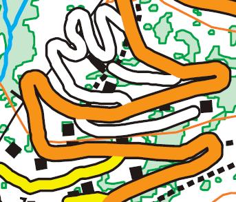


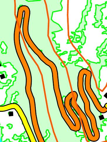


29 IGNF dataset Example: mountainous roads (a) Initial (e) Output 4 (i) Output 8 (b) Output 1 (f) Output 5 (j) Output 9 (c) Output 2 (g) Output 6 (h) Output 7
30 Expert evaluation: methodology Global indicators Level of manual editions required to meet the constraints Deviation from initial (ungeneralised) data Preservation of the geographic characteristics of the test area Legibility Seriousness and frequency of main detected errors Number of positive aspects Information reduction (undergeneralisation / overgeneralisation) Constraints on one object minimal dimensions granularity (amount of detail) shape preservation Individual constraints assessed in expert survey Constraints on two objects spatial separation between features (distance) relative position (e.g. building should remain at the same side of a road) consistencies between themes (e.g. contour line and river) Constraints on group of objects quantity of information (e.g. black/white ration) spatial distribution
31 Frequency of answers Frequency of answers Frequency of answers Good scores for: Expert evaluation: example results 3. Deviation from map of original data 4. Preservation of geographic characteristics ArcGIS Axpand Clarity CPT ArcGIS Axpand Clarity CPT Highly acceptable Acceptable Moderately acceptable Not acceptable 0 Good Above average Average Below average Poor 7. Information reduction Lower scores for: ArcGIS Clarity Axpand CPT Acceptable Undergeneralized Overgeneralized
32 Constraints in the EuroSDR project Introduction of the project Role of constraints in requirement analysis Constraints in evaluation Topics for discussions Overview
33 Topics for discussions (1/3) Constraints are well suited to apply to generalisation processes (flexible, distinction between conflict analysis and solution) Constraints used to direct the process and to evaluate if output meets specifications: be careful Constraints not always good indicator of quality
34 Topics for discussions (2/3) Results for individual constraints not a good indicator for overall solution: Violation may be intended Constraint may not define the situation well Good results for one constraint may coincide with bad results for another Non-satisfied constraint can be due to missing functionality OR due to imprecise constraint How well does the set of constraints describe the desired output: complete? balanced?
35 Further research Topics for discussions (3/3) More/complete set of/improve constraints Improve formalisation level: How to formalise preservation concepts+accepted change Enable notion of threshold values in constraints evaluation: Not interesting of a constraint is violated, but if this yields unacceptable situation Making constraints comparable How to aggregate the evaluation to one measure
36 osdr_gen_final_report_mar2010.pdf J.E. Stoter, 2011

37 Questions? Summary of the project available at ica.ign.fr, see workshop 2010 in Zurich: EuroSDR research on state-of-the-art of automated generalisation in commercial software: main findings and conclusions, 13th Workshop of the ICA commission on Generalisation and Multiple Representation
State-of-the-Art of Automated Generalisation in Commercial Software
 European Spatial Data Research November 2010 State-of-the-Art of Automated Generalisation in Commercial Software by Jantien Stoter Medium Format Cameras by Görres Grenzdörffer Official Publication No 58
The automatic generalisation of building polygons with ArcGIS standard tools based on the 1:50`000 Swiss National Map Series
 The automatic generalisation of building polygons with ArcGIS standard tools based on the 1:50`000 Swiss National Map Series A. Vetter 1, M. Wigley 1, D. Käuferle 2, G. Gartner 3 1 Esri Switzerland Ltd.,
TOPOLOGICAL CONSTRAINTS, ACTIONS AND REFLEXES FOR GENERALIZATION BY OPTIMIZATION
 10 th ICA Workshop on Generalisation and Multiple Representation, 2-3 August 2007, Moscow TOPOLOGICAL CONSTRAINTS, ACTIONS AND REFLEXES FOR GENERALIZATION BY OPTIMIZATION Jean-Luc Monnot, Paul Hardy, &
AN EXAMPLE OF DATABASE GENERALIZATION WORKFLOW: THE TOPOGRAPHIC DATABASE OF CATALONIA AT 1:25.000
 AN EXAMPLE OF DATABASE GENERALIZATION WORKFLOW: THE TOPOGRAPHIC DATABASE OF CATALONIA AT 1:25.000 Blanca Baella, Maria Pla Institut Cartogràfic de Catalunya 5th Workshop on Progress in Automated Map Generalization,
A framework to formalize multi-scales land-use generalization in the ScaleMaster 2.0
 A framework to formalize multi-scales land-use generalization in the ScaleMaster 2.0 Jean-François Girres 1, Guillaume Touya² 1 UMR GRED Université Paul Valéry Montpellier, Route de Mende 34199 Montpellier
Experiments to Distribute Map Generalization Processes
 Experiments to Distribute Map Generalization Processes Justin Berli, a Guillaume Touya, a Imran Lokhat, a and Nicolas Regnauld b a Univ. Paris-Est, LASTIG COGIT, IGN, ENSG, F-94160 Saint-Mande, France;
Contour Simplification with Defined Spatial Accuracy
 Contour Simplification with Defined Spatial Accuracy Bulent Cetinkaya, Serdar Aslan, Yavuz Selim Sengun, O. Nuri Cobankaya, Dursun Er Ilgin General Command of Mapping, 06100 Cebeci, Ankara, Turkey bulent.cetinkaya@hgk.mil.tr
La 3D : exemple des Pays-Bas et extension à EuroSDR Lambert2008 et INSPIRE
 UsersClub UrbIS, CIRB 2 juin 2016 La 3D : exemple des Pays-Bas et extension à EuroSDR Lambert2008 et INSPIRE Eric BAYERS Conseiller-Géographe Directeur de la PhotoTopographie Plan de la présentation Plan
CHARACTERIZATION AND DETECTION OF BUILDING PATTERNS IN CARTOGRAPHIC DATA: TWO ALGORITHMS
 CHARACTERIZATION AND DETECTION OF BUILDING PATTERNS IN CARTOGRAPHIC DATA: TWO ALGORITHMS Xiang Zhang a,b,, Tinghua Ai b, Jantien Stoter c,d a ITCt University of Twente,he Netherlands xzhang@itc.nl b School
A CONSISTENCY MAINTENANCE OF SHARED BOUNDARY AFTER POLYGON GENERALIZATION
 CO-182 A CONSISTENCY MAINTENANCE OF SHARED BOUNDARY AFTER POLYGON GENERALIZATION AI T.(1), ZHANG W.(2) (1) Wuhan University, WUHAN CITY, CHINA ; (2) Zhongnan University of Economics and Law, WUHAN CITY,
various parameter items of requirement formalization description can be obtained; Last Section is conclusion. 2. ANALYSIS OF USER DEMANDS In addition,
 RESEARCH ON THE FORMALIZATION DESCRIPTION OF USER REQUIREMENT IN GIS DEMAND-BASED SERVICES a,* CAI Yongxiang Huang ZhongYu b a. School of Geoscience, Yangtze University,1 Nanhu Road, Jingzhou, Hubei provience,
DEVELOPING A NEW GEOGRAPHICAL OBJECT DATABASE. EXPERIENCES FROM IDEA TO DELIVERING DATASETS TOP10NL
 DEVELOPING A NEW GEOGRAPHICAL OBJECT DATABASE. EXPERIENCES FROM IDEA TO DELIVERING DATASETS TOP10NL NICO J. BAKKER Topografische Dienst Kadaster Bendienplein 5 7815 SM Emmen, The Netherlands nbakker@tdkadaster.nl
A Review of the Clarity Generalisation Platform and the Customisations Developed at Ordnance Survey Research
 Abstract Customisations Developed at Ordnance Survey Research Patrick Revell patrick.revell@ordnancesurvey.co.uk Ordnance Survey Research, Romsey Road, Southampton, UK. Reproduced by permission of Ordnance
Advanced Map Labeling using Maplex. Wendy Harrison & Samuel Troth
 Advanced Map Labeling using Maplex Wendy Harrison & Samuel Troth Presentation Overview We ll be using ArcGIS Pro Introduction - Different types of text in ArcGIS - role of the Maplex Label Engine labeling
ArcGIS Multi-Scale and Generalization
 ArcGIS Multi-Scale and Generalization Paul Hardy 2014-12-04 Produce Many Information Products from One Database Production Workflows Authoritative Database Multi-scale Information products: Maps, Data,
AUTOMATIC CHARACTERISATION OF BUILDING ALIGNMENTS BY MEANS OF EXPERT KNOWLEDGE
 AUTOMATIC CHARACTERISATION OF BUILDING ALIGNMENTS BY MEANS OF EXPERT KNOWLEDGE Ruas, A. and Holzapfel, F. Laboratoire COGIT, IGN. 2 Avenue Pasteur, 94 165 Saint Mandé Cedex, France. Fax: 33 1 43 98 81
Multi-scale Mapping by Automated Generalisation & Active Representation
 What is Laser-Scan? Multi-scale Mapping by Automated Generalisation & Active Representation Paul Hardy (paul@lsl.co.uk), Chief Product Manager, Laser-Scan Ltd, http://www.laser-scan.com IMTA Barcelona,
Road Network Selection Using an Extended Stroke-Mesh Combination Algorithm
 Road Network Selection Using an Extended Stroke-Mesh Combination Algorithm S.A. Benz 1, R. Weibel 1 1 Department of Geography, University of Zurich, Winterthurerstr. 190, 8057 Zürich, Switzerland Email:
CONFLATION: EDGEMATCHING TOOLS AND WORKFLOWS DAN LEE
 CONFLATION: EDGEMATCHING TOOLS AND WORKFLOWS DAN LEE Agenda Conflation Overview and Geoprocessing Tools Edge Matching Workflow Demo Conclusions and Future Work Conflation Overview and Geoprocessing Tools
CONSISTENT LINE SIMPLIFICATION BASED ON CONSTRAINT POINTS
 CONSISTENT LINE SIMPLIFICATION BASED ON CONSTRAINT POINTS Shen Ying, Lin Li and Yuanyu Zhang School of Resource and Environment Science, Wuhan University, China, 430079. E-mail: senying@sina.com ABSTRACT
Automated schematic map production using simulated annealing and gradient descent approaches
 Automated schematic map production using simulated annealing and gradient descent approaches Suchith Anand 1, Silvania Avelar 2, J. Mark Ware 3, Mike Jackson 1 1 Centre for Geospatial Science, University
An Agent-Based Framework for Polygonal Subdivision Generalisation
 ISPRS SIPT IGU UCI CIG ACSG Table of contents Table des matières Authors index Index des auteurs Search Recherches Exit Sortir An Agent-Based Framework for Polygonal Subdivision Generalisation Martin Galanda
Map Generalization of Road Networks
 Dr. ing. Jan Terje Bjørke Norwegian Defence Research Establishment and Department of Mathematical Sciences and Technology The Agricultural University of Norway FFI, P.O. Box 115 NO-3191 Horten NORWAY fax:
Displacement Methods based on Field Analysis
 Displacement Methods based on Field Analysis Tinghua Ai Laboratory of Digital Mapping and Land Information Application Engineering Wuhan University, P. R. China aith@wuhan.cngb.com Peter van Oosterom Section
THE TOOLS OF AUTOMATED GENERALIZATION AND BUILDING GENERALIZATION IN AN ArcGIS ENVIRONMENT
 Vol. XIX, 2011, No. 1, 1 7, DOI: 10.2478/v10189-011-0001-4 V. DROPPOVÁ THE TOOLS OF AUTOMATED GENERALIZATION AND BUILDING GENERALIZATION IN AN ArcGIS ENVIRONMENT Veronika Droppová email: veronika.droppova@gmail.com
LSGI 521: Principles of GIS. Lecture 5: Spatial Data Management in GIS. Dr. Bo Wu
 Lecture 5: Spatial Data Management in GIS Dr. Bo Wu lsbowu@polyu.edu.hk Department of Land Surveying & Geo-Informatics The Hong Kong Polytechnic University Contents 1. Learning outcomes 2. From files to
Building pattern recognition in topographic data: examples on collinear and curvilinear alignments
 DOI 10.1007/s10707-011-0146-3 Building pattern recognition in topographic data: examples on collinear and curvilinear alignments Xiang Zhang Tinghua Ai Jantien Stoter Menno-Jan Kraak Martien Molenaar Received:
Advanced Parcel Editing. Amy Andis Tim Hodson
 Advanced Parcel Editing Amy Andis Tim Hodson Overview What to expect in this technical workshop Review of the Parcel Fabric Data Model Advanced Tips and tricks for Parcel entry Assessing Quality of Parcel
ENGRG Introduction to GIS
 ENGRG 59910 Introduction to GIS Michael Piasecki April 3, 2014 Lecture 11: Raster Analysis GIS Related? 4/3/2014 ENGRG 59910 Intro to GIS 2 1 Why we use Raster GIS In our previous discussion of data models,
Generalization Process for Loose Topological Relations of Regions
 Generalization Process for Loose Topological Relations of Regions BRAHIM LEJDEL,, OKBA KAZAR Smart Computer Science Laboratory, University of Biskra, Algeria. Computer science department, University Hamma
Modelling Topographic Information in Sri Lanka within a Multiple Representation Database Management System
 Modelling Topographic Information in Sri Lanka within a Multiple Representation Database Management System K.A.B.S.Rupasinghe March, 2006 Modelling Topographic Information in Sri Lanka within a Multiple
Introduction to digital image classification
 Introduction to digital image classification Dr. Norman Kerle, Wan Bakx MSc a.o. INTERNATIONAL INSTITUTE FOR GEO-INFORMATION SCIENCE AND EARTH OBSERVATION Purpose of lecture Main lecture topics Review
Deriving 1:250,000 from OS MasterMap
 Institute of Geography Online Paper Series: GEO-015 Rural and Urban Road Network Generalisation Deriving 1:250,000 from OS MasterMap Omair Chaudhry & William Mackaness Institute of Geography, School of
M. Andrea Rodríguez-Tastets. I Semester 2008
 M. -Tastets Universidad de Concepción,Chile andrea@udec.cl I Semester 2008 Outline refers to data with a location on the Earth s surface. Examples Census data Administrative boundaries of a country, state
Lecture 7 Digitizing. Dr. Zhang Spring, 2017
 Lecture 7 Digitizing Dr. Zhang Spring, 2017 Model of the course Using and making maps Navigating GIS maps Map design Working with spatial data Geoprocessing Spatial data infrastructure Digitizing File
Topic 5: Raster and Vector Data Models
 Geography 38/42:286 GIS 1 Topic 5: Raster and Vector Data Models Chapters 3 & 4: Chang (Chapter 4: DeMers) 1 The Nature of Geographic Data Most features or phenomena occur as either: discrete entities
Making Topographic Maps
 T O P O Applications N Making Topographic Maps M A P S Making Topographic Maps with TNTmips page 1 Before Getting Started TNTmips provides a variety of tools for working with map data and making topographic
Slide 1. Advanced Cartography in ArcGIS. Robert Jensen Edie Punt. Technical Workshops
 Slide 1 Technical Workshops Advanced Cartography in ArcGIS Robert Jensen Edie Punt Slide 2 Overview Using representations to manage symbology Solving graphic conflicts Geoprocessing for cartography in
NATIONWIDE POINT CLOUDS AND 3D GEO- INFORMATION: CREATION AND MAINTENANCE GEORGE VOSSELMAN
 NATIONWIDE POINT CLOUDS AND 3D GEO- INFORMATION: CREATION AND MAINTENANCE GEORGE VOSSELMAN OVERVIEW National point clouds Airborne laser scanning in the Netherlands Quality control Developments in lidar
LINE SIMPLIFICATION ALGORITHMS
 LINE SIMPLIFICATION ALGORITHMS Dr. George Taylor Work on the generalisation of cartographic line data, so that small scale map data can be derived from larger scales, has led to the development of algorithms
Automatic Building Extrusion from a TIN model Using LiDAR and Ordnance Survey Landline Data
 Automatic Building Extrusion from a TIN model Using LiDAR and Ordnance Survey Landline Data Rebecca O.C. Tse, Maciej Dakowicz, Christopher Gold and Dave Kidner University of Glamorgan, Treforest, Mid Glamorgan,
Incremental Update of Cartographic Data in a Versioned Environment
 Incremental Update of Cartographic Data in a Versioned Environment Marc-Olivier Briat, Jean-Luc Monnot, Thierry Kressmann ESRI Inc. Redlands, California, USA mbriat@esri.com, jmonnot@esri.com, tkressmann@esri.com
Partition and Conquer: Improving WEA-Based Coastline Generalisation. Sheng Zhou
 Partition and Conquer: Improving WEA-Based Coastline Generalisation Sheng Zhou Research, Ordnance Survey Great Britain Adanac Drive, Southampton, SO16 0AS, UK Telephone: (+44) 23 8005 5000 Fax: (+44) 23
Neighbourhood Operations Specific Theory
 Neighbourhood Operations Specific Theory Neighbourhood operations are a method of analysing data in a GIS environment. They are especially important when a situation requires the analysis of relationships
Getting the most from the Maplex Label Engine
 Esri International User Conference San Diego, California Technical Workshops July 26, 2012 Getting the most from the Maplex Label Engine Craig Williams Natalie Matthews 2 Presentation Overview What are
New Requirements for the Relief in the Topographic Databases of the Institut Cartogràfic de Catalunya
 New Requirements for the Relief in the Topographic Databases of the Institut Cartogràfic de Catalunya Blanca Baella, Maria Pla Institut Cartogràfic de Catalunya, Barcelona, Spain Abstract Since 1983 the
Object modeling and geodatabases. GEOG 419: Advanced GIS
 Object modeling and geodatabases GEOG 419: Advanced GIS CAD Data Model 1960s and 1970s Geographic data stored as points, lines, and areas No attributes; each feature type stored on a different layer No
Detecting Symmetries in Building Footprints by String Matching
 Detecting Symmetries in Building Footprints by String Matching Jan-Henrik Haunert Chair of Computer Science I, University of Würzburg, Am Hubland, 97074 Würzburg, Germany jan.haunert@uni-wuerzburg.de Abstract
Quality issues in LPIS: Towards Quality Assurance
 LPIS Workshop 2008, 17-18 September, 2008 1 Quality issues in LPIS: Towards Quality Assurance Valentina SAGRIS Geoinformation management GeoCAP AGRICULTURE UNIT EC - Joint Research Centre Relevant Quality
AN ITERATIVE PROCESS FOR MATCHING NETWORK DATA SETS WITH DIFFERENT LEVEL OF DETAIL
 AN ITERATIVE PROCESS FOR MATCHING NETWORK DATA SETS WITH DIFFERENT LEVEL OF DETAIL Yoonsik Bang, Chillo Ga and Kiyun Yu * Dept. of Civil and Environmental Engineering, Seoul National University, 599 Gwanak-ro,
BUILDINGS CHANGE DETECTION BASED ON SHAPE MATCHING FOR MULTI-RESOLUTION REMOTE SENSING IMAGERY
 BUILDINGS CHANGE DETECTION BASED ON SHAPE MATCHING FOR MULTI-RESOLUTION REMOTE SENSING IMAGERY Medbouh Abdessetar, Yanfei Zhong* State Key Laboratory of Information Engineering in Surveying, Mapping and
Data Assembly, Part II. GIS Cyberinfrastructure Module Day 4
 Data Assembly, Part II GIS Cyberinfrastructure Module Day 4 Objectives Continuation of effective troubleshooting Create shapefiles for analysis with buffers, union, and dissolve functions Calculate polygon
Redistricting and Geographic Deployment at the Ottawa Police Service Esri Canada User Conference Ottawa October 12, 2017
 Redistricting and Geographic Deployment at the Ottawa Police Service Esri Canada User Conference Ottawa October 12, 2017 Introduction Alyson Yaraskovitch, B.A., M.A. Crime Intelligence Analyst Ottawa Police
EnvSci360 Computer and Analytical Cartography
 EnvSci360 Computer and Analytical Cartography Lecture 5 Working with Type and Labels Key Points Labels are text that locate and identify features on a map Important for readability & communication EnvSci
Esri Best Practices: QA/QC For Your Geodata. Michelle Johnson & Chandan Banerjee
 Esri Best Practices: QA/QC For Your Geodata Michelle Johnson & Chandan Banerjee Overview Understand Document Implement Understanding QA/QC Understanding QA/QC Fit For Use - support your GIS applications?
Frameworks for Generalization Constraints and Operations Based on Object-Oriented Data Structure in Database Generalization
 Frameworks for Generalization Constraints and Operations Based on Object-Oriented Data Structure in Database Generalization Liu Yaolin 1, Martien Molenaar 2,Ai Tinghua 1 1 School of land information and
Implementation and testing of variable scale topological data structures
 Implementation and testing of variable scale topological data structures Experiences with the GAP-face tree and GAP-edge forest Master s thesis proposal by B.M. Meijers November 2005 Delft University of
Fractalopolis 1.0. User guide
 Fractalopolis 1.0 User guide Cécile Tannier, Gilles Vuidel October 2017 Contents 1 Introduction 2 1.1 About Fractalopolis......................................... 2 1.2 System requirements.........................................
Introduction to Geodatabase and Spatial Management in ArcGIS. Craig Gillgrass Esri
 Introduction to Geodatabase and Spatial Management in ArcGIS Craig Gillgrass Esri Session Path The Geodatabase - What is it? - Why use it? - What types are there? - What can I do with it? Query Layers
Announcements. Data Sources a list of data files and their sources, an example of what I am looking for:
 Data Announcements Data Sources a list of data files and their sources, an example of what I am looking for: Source Map of Bangor MEGIS NG911 road file for Bangor MEGIS Tax maps for Bangor City Hall, may
Topology in the Geodatabase: An Introduction
 Topology in the Geodatabase: An Introduction Colin Zwicker Erik Hoel ESRI Super Secret Topology Laboratory, May 2016 Agenda ArcGIS Topology defined Validating a topology Editing a topology Geoprocessing
Cell based GIS. Introduction to rasters
 Week 9 Cell based GIS Introduction to rasters topics of the week Spatial Problems Modeling Raster basics Application functions Analysis environment, the mask Application functions Spatial Analyst in ArcGIS
CPSC 695. Data Quality Issues M. L. Gavrilova
 CPSC 695 Data Quality Issues M. L. Gavrilova 1 Decisions Decisions 2 Topics Data quality issues Factors affecting data quality Types of GIS errors Methods to deal with errors Estimating degree of errors
Automatic Recognition and Resolution of Line Symbol Spatial Conflict in Cartography Based on Elastic Beams Model
 Automatic Recognition and Resolution of Line Symbol Spatial Conflict in Cartography Based on Elastic Beams Model Zhonghai YU 1, Yongbin Tan 1, Zhujun Xiang 2 1 School of Resource and Environment Science,
InfraGML. Linking pin between Geo and BIM. 4 november 2014
 InfraGML Linking pin between Geo and BIM Marcel Reuvers (Geonovum) 4 november 2014 GIS Roads DTM GIS scope: Scale 1:500 1:25:000 Coordinates system CRS Features Topology networks Themes Cables and pipes
Maps as Numbers: Data Models
 Maps as Numbers: Data Models vertices E Reality S E S arcs S E Conceptual Models nodes E Logical Models S Start node E End node S Physical Models 1 The Task An accurate, registered, digital map that can
ArcGIS Data Reviewer: Ensuring Accurate and Complete Data to Meet Your Mission. John Grammer Kevin Pusey
 ArcGIS Data Reviewer: Ensuring Accurate and Complete Data to Meet Your Mission John Grammer Kevin Pusey Workshop agenda Defining data quality What is ArcGIS Data Reviewer? Automated review Semi-automated
3-D Modeling of Angara River Bed
 3-D Modeling of Angara River Bed Igor Bychkov, Andrey Gachenko, Gennady Rugnikov, and Alexei Hmelnov Matrosov Institute for System Dynamics and Control Theory of Siberian Branch of Russian Academy of Sciences,
Topology in the Geodatabase an Introduction. Erik Hoel Doug Morgenthaler
 Topology in the Geodatabase an Introduction Erik Hoel Doug Morgenthaler ESRI Super Secret Topology Laboratory, May 2012 Agenda ArcGIS Topology defined Validating a topology Editing a topology Geoprocessing
Definition DQ measure / description Evaluation scope Applicable to spatial representation types
 DRAFT DATA QUALITY CHECKLIST drafted: 17 January 2018, Monaco for DQWG-13 Author: R. Broekman (DQWG-Chair) This list is derived from ISO 19157. Definitions and descriptions are a direct copy of ISO-19157.
AN ITERATIVE ALGORITHM FOR MATCHING TWO ROAD NETWORK DATA SETS INTRODUCTION
 AN ITERATIVE ALGORITHM FOR MATCHING TWO ROAD NETWORK DATA SETS Yoonsik Bang*, Student Jaebin Lee**, Professor Jiyoung Kim*, Student Kiyun Yu*, Professor * Civil and Environmental Engineering, Seoul National
Year 6 Maths Medium Term Planning. Autumn. Unit A1 Number place value, multiplication and division
 Year 6 Maths Medium Term Planning Autumn Unit A1 Number place value, multiplication and division Weeks 1&2 Explain reasoning and conclusions, using words, symbols or diagrams as appropriate Strand: Number
Unit Maps: Grade 8 Math
 Real Number Relationships 8.3 Number and operations. The student represents and use real numbers in a variety of forms. Representation of Real Numbers 8.3A extend previous knowledge of sets and subsets
MSc Geomatics thesis presentation. Validation and automatic repair of planar partitions using a constrained triangulation.
 MSc Geomatics thesis presentation Validation and automatic repair of planar partitions using a constrained triangulation Ken Arroyo Ohori Friday, 27 August 2010 at 10:00 Grote Vergaderzaal OTB Research
European Location Framework (ELF) acting as a facilitator implementing INSPIRE
 acting as a facilitator implementing INSPIRE") www.eurogeographics.org European Location Framework (ELF) acting as a facilitator implementing INSPIRE Saulius Urbanas, Mick Cory (EuroGeographics) 29 October 2016 Copyright 2013 EuroGeographics EuroGeographics
www.eurogeographics.org European Location Framework (ELF) acting as a facilitator implementing INSPIRE Saulius Urbanas, Mick Cory (EuroGeographics) 29 October 2016 Copyright 2013 EuroGeographics EuroGeographics
Creating Great Labels Using Maplex
 Esri International User Conference San Diego, CA Technical Workshops July 11 15, 2011 Creating Great Labels Using Maplex Craig Williams Natalie Vines 2 Presentation Overview What are the types of text
The Geographic Names Register of the National Land Survey of Finland
 7 June 2002 English only Eighth United Nations Conference on the Standardization of Geographical Names Berlin, 27 August-5 September 2002 Item 12 (d) of the provisional agenda * Toponymic data files: automated
CHANGE-ONLY MODELING IN NAVIGATION GEO-DATABASES
 CHANGE-ONLY MODELING IN NAVIGATION GEO-DATABASES YING Shen a, LI Lin a, LIU Xiaofei a, ZHAO Hu a, LI Dan b a School of Resource and Environment Science, Wuhan University.29 LUOYU Road, Wuhan 430079China.
Transformative characteristics and research agenda for the SDI-SKI step change:
 Transformative characteristics and research agenda for the SDI-SKI step change: A Cadastral Case Study Dr Lesley Arnold Research Fellow, Curtin University, CRCSI Director Geospatial Frameworks World Bank
RESULTS OF EXPERIMENTS ON AUTOMATED MATCHING OF NETWORKS AT DIFFERENT SCALES
 RESULTS OF EXPERIMENTS ON AUTOMATED MATCHING OF NETWORKS AT DIFFERENT SCALES Sébastien Mustière COGIT Laboratory, Institut Géographique National, 2 av. Pasteur, 94160 Saint-Mandé France, sebastien.mustiere@ign.fr
RESULTS OF EXPERIMENTS ON AUTOMATED MATCHING OF NETWORKS AT DIFFERENT SCALES
 RESULTS OF EXPERIMENTS ON AUTOMATED MATCHING OF NETWORKS AT DIFFERENT SCALES Sébastien Mustière COGIT Laboratory, Institut Géographique National, 2 av. Pasteur, 94160 Saint-Mandé France, sebastien.mustiere@ign.fr
Scalar Visualization
 Scalar Visualization Visualizing scalar data Popular scalar visualization techniques Color mapping Contouring Height plots outline Recap of Chap 4: Visualization Pipeline 1. Data Importing 2. Data Filtering
Morphing Polylines Based on Least-Squares Adjustment
 Morphing Polylines Based on Least-Squares Adjustment Dongliang Peng 1,3, Jan-Henrik Haunert 1, Alexander Wolff 1, Christophe Hurter 2 1 Institute of Computer Science, University of Würzburg, Germany http://www1.informatik.uni-wuerzburg.de/en/staff
Transformative characteristics and research agenda for the SDI-SKI step change: A Cadastral Case Study
 Transformative characteristics and research agenda for the SDI-SKI step change: A Cadastral Case Study Dr Lesley Arnold Research Fellow, Curtin University, CRCSI Director Geospatial Frameworks World Bank
Copyright The McGraw-Hill Companies, Inc. Permission required for reproduction or display.
 CHAPTER 11 VECTOR DATA ANALYSIS 11.1 Buffering 11.1.1 Variations in Buffering Box 11.1 Riparian Buffer Width 11.1.2 Applications of Buffering 11.2 Overlay 11.2.1 Feature Type and Overlay 11.2.2 Overlay
AN INTEGRATED SENSOR ORIENTATION SYSTEM FOR AIRBORNE PHOTOGRAMMETRIC APPLICATIONS
 AN INTEGRATED SENSOR ORIENTATION SYSTEM FOR AIRBORNE PHOTOGRAMMETRIC APPLICATIONS M. J. Smith a, *, N. Kokkas a, D.W.G. Park b a Faculty of Engineering, The University of Nottingham, Innovation Park, Triumph
QUALITY CONTROL METHOD FOR FILTERING IN AERIAL LIDAR SURVEY
 QUALITY CONTROL METHOD FOR FILTERING IN AERIAL LIDAR SURVEY Y. Yokoo a, *, T. Ooishi a, a Kokusai Kogyo CO., LTD.,Base Information Group, 2-24-1 Harumicho Fuchu-shi, Tokyo, 183-0057, JAPAN - (yasuhiro_yokoo,
Consolidation Team INSPIRE Annex I data specifications testing Call for Participation
 INSPIRE Infrastructure for Spatial Information in Europe Technical documents Consolidation Team INSPIRE Annex I data specifications testing Call for Participation Title INSPIRE Annex I data specifications
Automatic urbanity cluster detection in street vector databases with a raster-based algorithm
 Automatic urbanity cluster detection in street vector databases with a raster-based algorithm Volker Walter, Steffen Volz University of Stuttgart Institute for Photogrammetry Geschwister-Scholl-Str. 24D
Advanced Meshing Tools
 Page 1 Advanced Meshing Tools Preface Using This Guide More Information Conventions What's New? Getting Started Entering the Advanced Meshing Tools Workbench Defining the Surface Mesh Parameters Setting
Unit Maps: Grade 8 Math
 Real Number Relationships 8.3 Number and operations. The student represents and use real numbers in a variety of forms. Representation of Real Numbers 8.3A extend previous knowledge of sets and subsets
Snakes: a technique for line smoothing and displacement in map generalisation
 Snakes: a technique for line smoothing and displacement in map generalisation STEFAN STEINIGER, Zürich & SIEGFRIED MEIER, Dresden University of Zurich, Department of Geography, Winterthurerstrasse 190,
GENERALIZATION BASED ON LEAST SQUARES ADJUSTMENT
 GENERALIZATION BASED ON LEAST SQUARES ADJUSTMENT Monika SESTER Institute for Photogrammetry (ifp), Stuttgart University, Germany Geschwister-Scholl-Strasse 24d, D-70174 Stuttgart Monika.Sester@ifp.uni-stuttgart.de
FACET SHIFT ALGORITHM BASED ON MINIMAL DISTANCE IN SIMPLIFICATION OF BUILDINGS WITH PARALLEL STRUCTURE
 FACET SHIFT ALGORITHM BASED ON MINIMAL DISTANCE IN SIMPLIFICATION OF BUILDINGS WITH PARALLEL STRUCTURE GE Lei, WU Fang, QIAN Haizhong, ZHAI Renjian Institute of Surveying and Mapping Information Engineering
University of Zurich. Automated processing for map generalization with web services. Zurich Open Repository and Archive
 University of Zurich Zurich Open Repository and Archive Winterthurerstr. CH-0 Zurich http://www.zora.uzh.ch Year: 00 Automated processing for map generalization with web services Neun, M; Burghardt, D;
AUTOMATIC EXTRACTION OF BUILDING FEATURES FROM TERRESTRIAL LASER SCANNING
 AUTOMATIC EXTRACTION OF BUILDING FEATURES FROM TERRESTRIAL LASER SCANNING Shi Pu and George Vosselman International Institute for Geo-information Science and Earth Observation (ITC) spu@itc.nl, vosselman@itc.nl
Computing Curriculum Overview Autumn 1 Autumn 2 Spring 1 Spring 2 Summer 1 Summer 2 Creating digital content - linked to with theme topic -
 Computing Curriculum Overview 2018-2019 Year 1 Autumn 1 Autumn 2 Spring 1 Spring 2 Summer 1 Summer 2 Using technology Unit: Coding Unit: -link in Creating - linked to with theme topic - theme topic: Superheroes
Y9 Maths. Summative Assessment 1 hour written assessment based upon modules 1-5 during Autumn 2. Term Cycle 1
 Term Cycle 1 Whole Numbers and Decimals Powers of 10 Rounding Order of operations Multiples, factors, divisibility and prime numbers Prime factors, the HCF and the LCM Ordering decimals Estimating and
Enhancing building footprints with squaring operations
 JOURNAL OF SPATIAL INFORMATION SCIENCE Number 13 (2016), pp 33 60 doi:105311/josis201613276 RESEARCH ARTICLE Enhancing building footprints with squaring operations Imran Lokhat and Guillaume Touya COGIT
GEOGRAPHIC INFORMATION SYSTEMS Lecture 18: Spatial Modeling
 Spatial Analysis in GIS (cont d) GEOGRAPHIC INFORMATION SYSTEMS Lecture 18: Spatial Modeling - the basic types of analysis that can be accomplished with a GIS are outlined in The Esri Guide to GIS Analysis