Integration of Textural and Material Information Into Existing BIM Using IR Sensing. A research by: Asem Zabin Baha Khalil
|
|
|
- Colleen Morrison
- 6 years ago
- Views:
Transcription


1 Integration of Textural and Material Information Into Existing BIM Using IR Sensing A research by: Asem Zabin Baha Khalil


2 Asem Zabin Senior BIM Engineer at itech Management Consultancy Master of Science in Civil Engineering (MSCE) Winner of the BIM For Innovation Award for Hyperloop Competition Area of interests: BIM for Infrastructure, Satellite Remote Sensing, As-Built BIM, BIM for FM, Post-construction BIM analysis Presenters Background Baha Khalil Data Scientist at Unilever Master of Science in Mathematics Area of interests: Convex optimization, Neural networks
3 Contents Problem statement IR Camera Texture analysis Math + case study Q&A
4 The Problem Why do we need Asbuilt BIM? As-built BIM is now done using laser scanners. Limitations: laser scanners are limited (Only geometry is identified) Surface Materials? Texture Homogeneity? Solution A Semi-automated method that is able to identify an unknown material and texture and then integrate it with BIM.

5 Introduction As-Built Definition: Set of drawing and documents submitted by a contractor upon completion of a project or a particular job. Reflect all changes made in the specifications and working drawings during the construction process. Show the exact dimensions, geometry, and location of all elements of the work completed under the contract. Also known as record drawings or as is. Applications


6 As-Built Drawings Problem Statement Rolls of drawings from the architect and engineers Folders of equipment information for each type of equipment 2D CAD Files

")
7 Current Data Acquisition Methods Use of Barcodes in Construction to extract location information of objects Radio Frequency Identification (RFID) tags Laser Scanners or Light Detection And Ranging (LiDAR) Photogrammetry

 sensing is a form of remote sensing that employs electromagnetic radiations (EMR) between the visible")
8 Remote Sensing, Infrared (IR) Remote Sensing is the science and art of capturing information about objects, areas, or a phenomenon through the analysis of data acquired by device that is not in physical contact with the object, area or the phenomenon. Infrared (IR) sensing is a form of remote sensing that employs electromagnetic radiations (EMR) between the visible and microwave radiations in the wavelength range from 700 nanometer at the edge of the red to about 1 mm.


9 Thermal IR Camera Advantages in Construction: - It s contactless, therefore nondestructive and reactionless. - It can be used to measure objects in very hot and difficult-to-access areas. - It allows for rapid data acquisition. - It measures the temperature of a solid-state body surface not the surrounding atmosphere.


10 Texture Image texture is the frequency of tonal change of an image Smoothness Coarseness Heterogeneity of classes Contrast Uniformity


11 Over the past decade, multiple striving efforts have been made to make computers acquire, understand, index, and interpret images expressing a wide variety of concepts, with much progress Texture Extraction The objective is to retrieve texture with high accuracy utilizing the least complicated computational approaches. A main form of image processing is image classification, which means segmenting the image into homogeneous zones and labeling the resulted zones with distinct class labels. Previous Researches
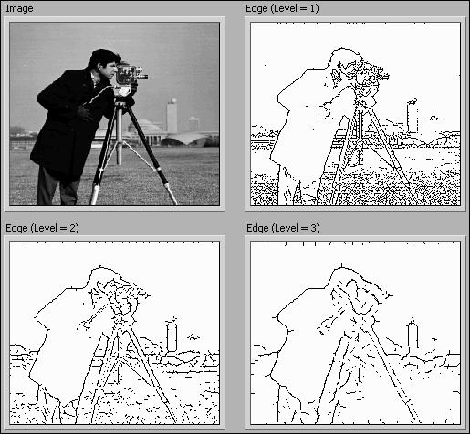
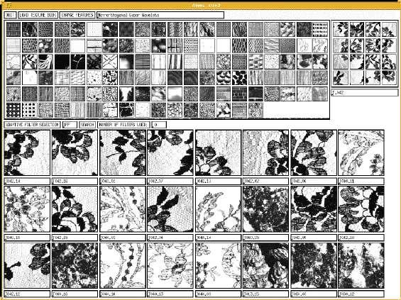


12 Previous Researches Edge Detection Machine Learning
13 Objectives Extract material and textural information of an existing building interior walls using a thermal infrared camera. Develop a framework for representing, organizing, and integrating the acquired material and textural data into the BIM. Perform basic analysis on the rich BIM after integrating the new information to explore the advantages and limitations of the study for the industry.

14 Methodology 1.Take the picture of the unknown structure 2.Feed the image to the code 3.Algorithm will identify the materials in the provided images
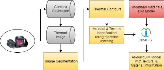
15 Methodology
16 Materials Identification
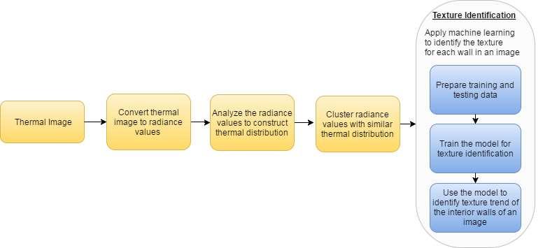
17 Texture Identification
")
18 Material and Texture Identification Using Gaussian Mixture Models (GMM)
 Normalized Radiance Values of Different Walls")
19 Material and Texture Identification Using Gaussian Mixture Models (GMM) Normalized Radiance Values of Different Walls Materials
 Gaussian Mixture Models (GMM) for Concrete & Gypsum")
20 Material and Texture Identification Using Gaussian Mixture Models (GMM) Gaussian Mixture Models (GMM) for Concrete & Gypsum board

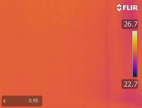
21 Data Acquisition (Gypsum Board)

22 Data Acquisition (Concrete)
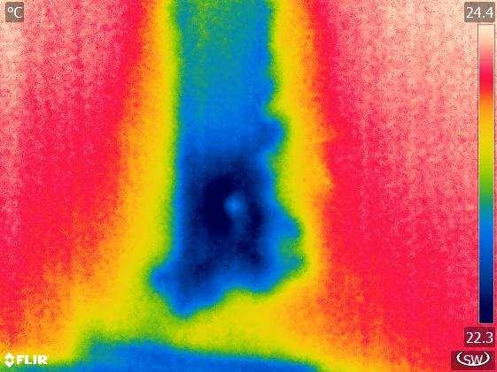

23 Data Acquisition (Concrete)

24 An algorithm which automatically extracts textural information was developed and applied, needed for identification of the walls. Feature Extraction This texture segmentation algorithm splits the image into different homogeneous texture regions

25 Exploration


26 Materials & Methodology Data Analysis: Monte Carlo Simulation Monte Carlo Simulation is a modeling and simulating technique that generates several scenarios and gathers relevant statistics in order to assess relationship between the variable in question and a model of interest. This method is often used when the model is nonlinear, or involves more than just a couple uncertain parameters. In each scenario, different means and standard deviations were simulated and the relationship between them was noted. Bell-shape distribution of Radiance values

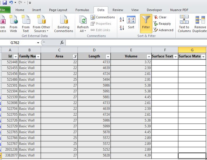
27 Results Data Integration in BIM

28 Results Data Integration in BIM

29 Results Data Integration in BIM

30 Results Data Integration in BIM


31 Results Data Integration in BIM

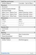
32 Results Data Integration in BIM
33 Conclusions Thermal Image Acquisition Integration with BIM Model State of Art Artificial Intelligence Feature Extraction (Interior Walls) Data Analysis Testing and Validation The proposed method used thermal infrared sensing to capture thermal images of the interior walls of an existing building. These images were then processed, and only wall features were extracted using a texture feature extraction algorithm. The resulted sub-images were then transformed into temperature values at each pixel of the interior walls.
34 Conclusions Thermal Image Acquisition Integration with BIM Model State of Art Artificial Intelligence Feature Extraction (Interior Walls) Data Analysis Testing and Validation A statistical correlations between the mean and standard deviation of interior gypsum and concrete were obtained through a Monte Carlo simulation approach. The extracted texture and material information were then integrated in the BIM Model.


35 Conclusions Texture Rich BIM models can be used in LIVE assessment of building conditions in relation to energy efficiency and water and waste systems leaks.
Remote Sensing Introduction to the course
 Remote Sensing Introduction to the course Remote Sensing (Prof. L. Biagi) Exploitation of remotely assessed data for information retrieval Data: Digital images of the Earth, obtained by sensors recording
Missile Simulation in Support of Research, Development, Test Evaluation and Acquisition
 NDIA 2012 Missile Simulation in Support of Research, Development, Test Evaluation and Acquisition 15 May 2012 Briefed by: Stephanie Brown Reitmeier United States Army Aviation and Missile Research, Development,
CHAPTER 5 OBJECT ORIENTED IMAGE ANALYSIS
 85 CHAPTER 5 OBJECT ORIENTED IMAGE ANALYSIS 5.1 GENERAL Urban feature mapping is one of the important component for the planning, managing and monitoring the rapid urbanized growth. The present conventional
Reverse Engineering: Mechanical. Dr. Tarek A. Tutunji
 Reverse Engineering: Mechanical Dr. Tarek A. Tutunji Mechanical RE References: 1. RE (reverse engineering) as necessary phase by rapid product development by Sokovic and Kopac 2. A Practical Appreciation
CLASSIFICATION OF NONPHOTOGRAPHIC REMOTE SENSORS
 CLASSIFICATION OF NONPHOTOGRAPHIC REMOTE SENSORS PASSIVE ACTIVE DIGITAL CAMERA THERMAL (e.g. TIMS) VIDEO CAMERA MULTI- SPECTRAL SCANNERS VISIBLE & NIR MICROWAVE HYPERSPECTRAL (e.g. AVIRIS) SLAR Real Aperture
Research on the New Image De-Noising Methodology Based on Neural Network and HMM-Hidden Markov Models
 Research on the New Image De-Noising Methodology Based on Neural Network and HMM-Hidden Markov Models Wenzhun Huang 1, a and Xinxin Xie 1, b 1 School of Information Engineering, Xijing University, Xi an
COMBINING HIGH SPATIAL RESOLUTION OPTICAL AND LIDAR DATA FOR OBJECT-BASED IMAGE CLASSIFICATION
 COMBINING HIGH SPATIAL RESOLUTION OPTICAL AND LIDAR DATA FOR OBJECT-BASED IMAGE CLASSIFICATION Ruonan Li 1, Tianyi Zhang 1, Ruozheng Geng 1, Leiguang Wang 2, * 1 School of Forestry, Southwest Forestry
Appendix III: Ten (10) Specialty Areas - Remote Sensing/Imagry Science Curriculum Mapping to Knowledge Units-RS/Imagry Science Specialty Area
 Specialty Areas - Remote Sensing/Imagry Science Curriculum Mapping to Knowledge Units-RS/Imagry Science Specialty Area") III. Remote Sensing/Imagery Science Specialty Area 1. Knowledge Unit title: Remote Sensing Collection Platforms A. Knowledge Unit description and objective: Understand and be familiar with remote sensing
III. Remote Sensing/Imagery Science Specialty Area 1. Knowledge Unit title: Remote Sensing Collection Platforms A. Knowledge Unit description and objective: Understand and be familiar with remote sensing
BIM for infrastructure make easy with Laser Scanner. 17 October Beng Chieh Quah Head of Marketing Asia Pacific
 BIM for infrastructure make easy with Laser Scanner 17 October 2016 Beng Chieh Quah Head of Marketing Asia Pacific who is? founded in 1981 NASDAQ since 1997 Global technology company Offering a range of
Sensor Modalities. Sensor modality: Different modalities:
 Sensor Modalities Sensor modality: Sensors which measure same form of energy and process it in similar ways Modality refers to the raw input used by the sensors Different modalities: Sound Pressure Temperature
Drywall state detection in image data for automatic indoor progress monitoring C. Kropp, C. Koch and M. König
 Drywall state detection in image data for automatic indoor progress monitoring C. Kropp, C. Koch and M. König Chair for Computing in Engineering, Department of Civil and Environmental Engineering, Ruhr-Universität
HIGH-DEFINITION SURVEY AND BIM PRESENTATION FOR BIM-MEP AUS
 www.aamgroup.com/bim HIGH-DEFINITION SURVEY AND BIM PRESENTATION FOR BIM-MEP AUS Matt Rumbelow, B.Arch AAM BIM Coordinator ABOUT AAM Reality Captured. Certainty Delivered Reality Captured. Certainty Delivered
FOUR-BAND THERMAL MOSAICKING: A NEW METHOD TO PROCESS THERMAL IMAGERY FROM UAV FLIGHT YICHEN YANG YALE SCHOOL OF FORESTRY AND ENVIRONMENTAL STUDIES
 FOUR-BAND THERMAL MOSAICKING: A NEW METHOD TO PROCESS THERMAL IMAGERY FROM UAV FLIGHT YICHEN YANG YALE SCHOOL OF FORESTRY AND ENVIRONMENTAL STUDIES OUTLINE Background Objectives Methodology Results Calibration
IMAGINE Objective. The Future of Feature Extraction, Update & Change Mapping
 IMAGINE ive The Future of Feature Extraction, Update & Change Mapping IMAGINE ive provides object based multi-scale image classification and feature extraction capabilities to reliably build and maintain
Keywords: industrial photogrammetry, quality control, small aircraft
 INVESTIGATING OFF-LINE LOW COST PHOTOGRAMMETRY APPLIED TO SMALL AIRCRAFT QULAITY CONTROL Dr M. Varshosaz, A. Amini Department of Photogrammetry and Remote Sensing, Faculty of Geodesy and Geomatics Engineering,
Using Mobile LiDAR To Efficiently Collect Roadway Asset and Condition Data. Pierre-Paul Grondin, B.Sc. Surveying
 Using Mobile LiDAR To Efficiently Collect Roadway Asset and Condition Data Pierre-Paul Grondin, B.Sc. Surveying LIDAR (Light Detection and Ranging) The prevalent method to determine distance to an object
GrayCut Object Segmentation in IR-Images
 Department of Signal Processing and Communications Prof. Dr.-Ing. Udo Zölzer GrayCut Object Segmentation in IR-Images Christian Ruwwe & Udo Zölzer 2 nd International Symposium on Visual Computing (ISVC)
Reverse Engineering Tool to improve quality and efficiency of design, manufacture and analysis.
 Reverse Engineering Tool to improve quality and efficiency of design, manufacture and analysis. INTRODUCTION The Internet and technology in general has forever changed the world. This dawning of the technical
Introduction to Remote Sensing Wednesday, September 27, 2017
 Lab 3 (200 points) Due October 11, 2017 Multispectral Analysis of MASTER HDF Data (ENVI Classic)* Classification Methods (ENVI Classic)* SAM and SID Classification (ENVI Classic) Decision Tree Classification
UNIT 22. Remote Sensing and Photogrammetry. Start-up. Reading. In class discuss the following questions:
 UNIT 22 Remote Sensing and Photogrammetry Start-up In class discuss the following questions: A. What do you know about remote sensing? B. What does photogrammetry do? C. Is there a connection between the
Microwave. Infrared. Preprogrammed Chip
 Advanced Technology for Design Mapping and Construction Layout AACE A.A.C.E. Meeting August 5, 2009 Daniel K. Mardock RBF Consulting Survey Manager Registered Land Surveyor Certified Federal Surveyor Arizona
Continued Development of the Look-up-table (LUT) Methodology For Interpretation of Remotely Sensed Ocean Color Data
 Methodology For Interpretation of Remotely Sensed Ocean Color Data") Continued Development of the Look-up-table (LUT) Methodology For Interpretation of Remotely Sensed Ocean Color Data Curtis D. Mobley Sequoia Scientific, Inc. 2700 Richards Road, Suite 107 Bellevue, WA
Continued Development of the Look-up-table (LUT) Methodology For Interpretation of Remotely Sensed Ocean Color Data Curtis D. Mobley Sequoia Scientific, Inc. 2700 Richards Road, Suite 107 Bellevue, WA
Building Information Modeling
 Chapter Building Information Modeling 1 Building information modeling (BIM) is an integrated workflow built on coordinated, reliable information about a project from design through construction and into
Analysis of Image and Video Using Color, Texture and Shape Features for Object Identification
 IOSR Journal of Computer Engineering (IOSR-JCE) e-issn: 2278-0661,p-ISSN: 2278-8727, Volume 16, Issue 6, Ver. VI (Nov Dec. 2014), PP 29-33 Analysis of Image and Video Using Color, Texture and Shape Features
Architectural Technology
 Architectural Technology The Architectural Technology curriculum prepares individuals to apply technical knowledge and skills to the fields of architecture, construction, construction management, facility
TOA RADIANCE SIMULATOR FOR THE NEW HYPERSPECTRAL MISSIONS: STORE (SIMULATOR OF TOA RADIANCE)
") TOA RADIANCE SIMULATOR FOR THE NEW HYPERSPECTRAL MISSIONS: STORE (SIMULATOR OF TOA RADIANCE) Malvina Silvestri Istituto Nazionale di Geofisica e Vulcanologia In the frame of the Italian Space Agency (ASI)
TOA RADIANCE SIMULATOR FOR THE NEW HYPERSPECTRAL MISSIONS: STORE (SIMULATOR OF TOA RADIANCE) Malvina Silvestri Istituto Nazionale di Geofisica e Vulcanologia In the frame of the Italian Space Agency (ASI)
Recent Advances in MSC/PATRAN Pre-Processing Software Allows Modeling of Complex Automotive Lamp Designs
 Recent Advances in MSC/PATRAN Pre-Processing Software Allows Modeling of Complex Automotive Lamp Designs William I. Moore, Eric S. Donovan and Christopher R. Powers Delphi Interior and Lighting Systems
COMBINING UAV AND FAST DATA ANALYSIS TO IDENTIFY VEGETATION THREATS TO POWER LINES
 COMBINING UAV AND FAST DATA ANALYSIS TO IDENTIFY VEGETATION THREATS TO POWER LINES 1 UAV TO BUSINESS DECISIONS 100 People 100 Countries $25M raised 2 BVLOS SINCE 2012 BVLOS flights in 30+ countries MINI
Aerial photography: Principles. Visual interpretation of aerial imagery
 Aerial photography: Principles Visual interpretation of aerial imagery Overview Introduction Benefits of aerial imagery Image interpretation Elements Tasks Strategies Keys Accuracy assessment Benefits
IR-Signature of the MULDICON Configuration Determined by the IR-Signature Model MIRA
 DLR.de Folie 1 IR-Signature of the MULDICON Configuration Determined by the IR-Signature Model MIRA Erwin Lindermeir*, Markus Rütten DLR German Aerospace Center *Remote Sensing Technology Institute Institute
GEOMETRIC AND MAPPING POTENTIAL OF WORLDVIEW-1 IMAGES
 GEOMETRIC AND MAPPING POTENTIAL OF WORLDVIEW-1 IMAGES G. Buyuksalih*, I. Baz*, S. Bayburt*, K. Jacobsen**, M. Alkan *** * BIMTAS, Tophanelioglu Cad. ISKI Hizmet Binasi No:62 K.3-4 34460 Altunizade-Istanbul,
GEOBIA for ArcGIS (presentation) Jacek Urbanski
 Jacek Urbanski") GEOBIA for ArcGIS (presentation) Jacek Urbanski INTEGRATION OF GEOBIA WITH GIS FOR SEMI-AUTOMATIC LAND COVER MAPPING FROM LANDSAT 8 IMAGERY Presented at 5th GEOBIA conference 21 24 May in Thessaloniki.
GEOBIA for ArcGIS (presentation) Jacek Urbanski INTEGRATION OF GEOBIA WITH GIS FOR SEMI-AUTOMATIC LAND COVER MAPPING FROM LANDSAT 8 IMAGERY Presented at 5th GEOBIA conference 21 24 May in Thessaloniki.
Development of system and algorithm for evaluating defect level in architectural work
 icccbe 2010 Nottingham University Press Proceedings of the International Conference on Computing in Civil and Building Engineering W Tizani (Editor) Development of system and algorithm for evaluating defect
Crossrail: A Case Study in BIM (Draft 26 th July 2013)
") Crossrail: A Case Study in BIM (Draft 26 th July 2013) Crossrail: A Case Study in BIM Malcolm Taylor Crossrail Head of Technical Information 29 th October 2013 Agenda Briefly set the scene What BIM in
Crossrail: A Case Study in BIM (Draft 26 th July 2013) Crossrail: A Case Study in BIM Malcolm Taylor Crossrail Head of Technical Information 29 th October 2013 Agenda Briefly set the scene What BIM in
3D BUILDINGS MODELLING BASED ON A COMBINATION OF TECHNIQUES AND METHODOLOGIES
 3D BUILDINGS MODELLING BASED ON A COMBINATION OF TECHNIQUES AND METHODOLOGIES Georgeta Pop (Manea), Alexander Bucksch, Ben Gorte Delft Technical University, Department of Earth Observation and Space Systems,
Appendix E. Development of methodologies for Brightness Temperature evaluation for the MetOp-SG MWI radiometer. Alberto Franzoso (CGS, Italy)
") 111 Appendix E Development of methodologies for Brightness Temperature evaluation for the MetOp-SG MWI radiometer Alberto Franzoso (CGS, Italy) Sylvain Vey (ESA/ESTEC, The Netherlands) 29 th European Space
111 Appendix E Development of methodologies for Brightness Temperature evaluation for the MetOp-SG MWI radiometer Alberto Franzoso (CGS, Italy) Sylvain Vey (ESA/ESTEC, The Netherlands) 29 th European Space
Hyperspectral Remote Sensing
 Hyperspectral Remote Sensing Multi-spectral: Several comparatively wide spectral bands Hyperspectral: Many (could be hundreds) very narrow spectral bands GEOG 4110/5100 30 AVIRIS: Airborne Visible/Infrared
Image segmentation. Václav Hlaváč. Czech Technical University in Prague
 Image segmentation Václav Hlaváč Czech Technical University in Prague Center for Machine Perception (bridging groups of the) Czech Institute of Informatics, Robotics and Cybernetics and Faculty of Electrical
GIS Data Collection. This chapter reviews the main methods of GIS data capture and transfer and introduces key practical management issues.
 9 GIS Data Collection OVERVIEW This chapter reviews the main methods of GIS data capture and transfer and introduces key practical management issues. It distinguishes between primary (direct measurement)
Application of partial differential equations in image processing. Xiaoke Cui 1, a *
 3rd International Conference on Education, Management and Computing Technology (ICEMCT 2016) Application of partial differential equations in image processing Xiaoke Cui 1, a * 1 Pingdingshan Industrial
COST Action TU1208 Civil Engineering Applications of Ground
 COST Action TU1208 Civil Engineering Applications of Ground Penetrating Radar Training School on Electromagnetic Modelling Techniques for Ground Penetrating Radar 9-12 November, 2016, Split (Croatia) Electromagnetic
ASNT Conference
 ASNT Conference - 2017 Automated Remote Inspections Using Spatial Phase Imaging Preston Bornman Director - Photon-X NASA Johnson Space Center Houston, Texas photon-x.com About LLC designs and builds optical
Thermal and Optical Cameras. By Philip Smerkovitz TeleEye South Africa
 Thermal and Optical Cameras By Philip Smerkovitz TeleEye South Africa phil@teleeye.co.za OPTICAL CAMERAS OVERVIEW Traditional CCTV Camera s (IP and Analog, many form factors). Colour and Black and White
BIM PROCESS COMPARING NEW BUILD WITH EXISTING ASSETS A VERY QUICK SUMMARY OF THE PROCESS
 : STEPPING INTO THE FUTURE WITH THE PAST HYBRID MODELLING IN THE BIM PROCESS CARL BROOKES 8 DECEMBER 2017 INTRODUCTION Very quick summary of BIM process Comparing New build with existing assets 3D model
Vancouver Math Olympiad
 Vancouver Math Olympiad Competition #1: November 21 st, 2014 @ NWSS Library Game #1: Hands-on Geometry This game consists of both a theoretical as well as a practical portion. Your group will be given
DIGITAL IMAGE ANALYSIS. Image Classification: Object-based Classification
 DIGITAL IMAGE ANALYSIS Image Classification: Object-based Classification Image classification Quantitative analysis used to automate the identification of features Spectral pattern recognition Unsupervised
Mobile Robotics. Mathematics, Models, and Methods. HI Cambridge. Alonzo Kelly. Carnegie Mellon University UNIVERSITY PRESS
 Mobile Robotics Mathematics, Models, and Methods Alonzo Kelly Carnegie Mellon University HI Cambridge UNIVERSITY PRESS Contents Preface page xiii 1 Introduction 1 1.1 Applications of Mobile Robots 2 1.2
Presentation title. Presenters name
 Presentation title Presenters name Andrew Bellerby, Managing Director, Solibri UK Ltd Four segments Nemetschek covers the complete value chain in AEC + Multimedia Facts and figures > 50 years of innovation,
Automotive Thermal Management for Full Vehicles
 Automotive Thermal Management for Full Vehicles Concerning the thermal behavior of automotive vehicles it is pursued to accomplish simulations for the full complexity of a vehicle's geometry and transport
The Most Comprehensive Solution for Indoor Mapping Applications
 The Most Comprehensive Solution for Indoor Mapping Applications TRIMBLE INDOOR MOBILE MAPPING SOLUTION TRIMBLE INDOOR MOBILE MAPPING SOLUTION (TIMMS): HIGH EFFICIENCY, MAXIMUM FLEXIBILITY, ALL-IN-ONE PACKAGE
INTEGRATING DATA FROM 3D CAD AND 3D CAMERAS FOR REAL-TIME MODELING
 INTEGRATING DATA FROM 3D CAD AND 3D CAMERAS FOR REAL-TIME MODELING Frederic Bosche1, Jochen Teizer2, Carl T. Haas3 and Carlos H. Caldas4 ABSTRACT In a reversal of historic trends, the capital facilities
Three-Dimensional Scanning and Graphic Processing System
 Volume 55, Number 1-2, 2014 83 Three-Dimensional Scanning and Graphic Processing System Valentin Dan ZAHARIA, Rodica HOLONEC, Septimiu CRIŞAN, Călin MUREŞAN, Radu MUNTEANU jr. Faculty of Electrical Engineering,
USING IMAGES PATTERN RECOGNITION AND NEURAL NETWORKS FOR COATING QUALITY ASSESSMENT Image processing for quality assessment
 USING IMAGES PATTERN RECOGNITION AND NEURAL NETWORKS FOR COATING QUALITY ASSESSMENT Image processing for quality assessment L.-M. CHANG and Y.A. ABDELRAZIG School of Civil Engineering, Purdue University,
Draper Aden VIRTUAL CONSTRUCTION DOCUMENT, DESIGN, AND BUILD IN 3D
 VIRTUAL CONSTRUCTION VIRTUAL CONSTRUCTION The design and construction environment has changed. While the goals of completing a project on time, within budget, and at the expected level of quality remain
Building Information Modeling
 Chapter Building Information Modeling 1 Building information modeling (BIM) is an integrated workflow built on coordinated, reliable information about a project from design through construction and into
THE ANALYSIS OF METHODS FOR COMPUTER AIDED PROCESS PLANNING
 Edward GAWLIK Cracow University of Technology, Cracow, Poland THE ANALYSIS OF METHODS FOR COMPUTER AIDED PROCESS PLANNING 1. Introduction Summary: This paper presents the analysis of most important methods
Science Textbook and Instructional Materials Correlation to the 2010 Physics Standards of Learning and Curriculum Framework. Publisher Information
 Publisher Information Copyright date 2009 Contact Carol Kornfeind Phone# 847-486-2065 E-mail carol.kornfeind@pearson.com Physics 1 of 16 Virginia Department of Education PH.1 The student will plan and
Surface Shape Regions as Manifestations of a Socio-economic Phenomenon
 Surface Shape Regions as Manifestations of a Socio-economic Phenomenon a solution to the choropleth mapping problem by John (Jack) Sirles Massey a thesis submitted for the degree of Master of Science in
Unwrapping of Urban Surface Models
 Unwrapping of Urban Surface Models Generation of virtual city models using laser altimetry and 2D GIS Abstract In this paper we present an approach for the geometric reconstruction of urban areas. It is
UNIT 0 - MEASUREMENT AND GEOMETRY CONCEPTS AND RELATIONSHIPS
 UNIT 0 - MEASUREMENT AND GEOMETRY CONCEPTS AND RELATIONSHIPS UNIT 0 - MEASUREMENT AND GEOMETRY CONCEPTS AND RELATIONSHIPS... 1 INTRODUCTION MATH IS LIKE A DATING SERVICE... 3 A FRAMEWORK FOR UNDERSTANDING
IMPROVEMENTS TO MONK & MCBEND ENABLING COUPLING & THE USE OF MONK CALCULATED ISOTOPIC COMPOSITIONS IN SHIELDING & CRITICALITY
 IMPROVEMENTS TO MONK & MCBEND ENABLING COUPLING & THE USE OF MONK CALCULATED ISOTOPIC COMPOSITIONS IN SHIELDING & CRITICALITY N. Davies, M.J. Armishaw, S.D. Richards and G.P.Dobson Serco Technical Consulting
Object-Based Classification & ecognition. Zutao Ouyang 11/17/2015
 Object-Based Classification & ecognition Zutao Ouyang 11/17/2015 What is Object-Based Classification The object based image analysis approach delineates segments of homogeneous image areas (i.e., objects)
9/14/2011. Contents. Lecture 3: Spatial Data Acquisition in GIS. Dr. Bo Wu Learning Outcomes. Data Input Stream in GIS
 Contents Lecture 3: Spatial Data Acquisition in GIS Dr. Bo Wu lsbowu@polyu.edu.hk 1. Learning outcomes. Data acquisition: Manual digitization 3. Data acquisition: Field survey 4. Data acquisition: Remote
Digital Preservation of the Aurelius Church and the Hirsau Museum Complex by Means of HDS and Photogrammetric Texture Mapping
 Master Thesis Ruxandra MOROSAN Ruxandra MOROSAN Digital Preservation of the Aurelius Church and the Hirsau Museum Complex by Means of HDS and Photogrammetric Texture Mapping Duration of the Thesis: 6 months
Airborne LiDAR Data Acquisition for Forestry Applications. Mischa Hey WSI (Corvallis, OR)
") Airborne LiDAR Data Acquisition for Forestry Applications Mischa Hey WSI (Corvallis, OR) WSI Services Corvallis, OR Airborne Mapping: Light Detection and Ranging (LiDAR) Thermal Infrared Imagery 4-Band
Airborne LiDAR Data Acquisition for Forestry Applications Mischa Hey WSI (Corvallis, OR) WSI Services Corvallis, OR Airborne Mapping: Light Detection and Ranging (LiDAR) Thermal Infrared Imagery 4-Band
Three-dimensional nondestructive evaluation of cylindrical objects (pipe) using an infrared camera coupled to a 3D scanner
 using an infrared camera coupled to a 3D scanner") Three-dimensional nondestructive evaluation of cylindrical objects (pipe) using an infrared camera coupled to a 3D scanner F. B. Djupkep Dizeu, S. Hesabi, D. Laurendeau, A. Bendada Computer Vision and
Three-dimensional nondestructive evaluation of cylindrical objects (pipe) using an infrared camera coupled to a 3D scanner F. B. Djupkep Dizeu, S. Hesabi, D. Laurendeau, A. Bendada Computer Vision and
Digital Softcopy Photogrammetry
 LLP Erasmus IP EPOCHE 2013 Thassos Island, Greece, 2-16 June 2013 Digital Softcopy Photogrammetry Prof. Levente DIMEN The 1 Decembrie 1918 University of Alba Iulia, Romania GENERAL CONTEXT In the last
White Paper 3D Geometry Visualization Capability for MCNP
 White Paper 3D Geometry Visualization Capability for MCNP J. B. Spencer, J. A. Kulesza, A. Sood Los Alamos National Laboratory Monte Carlo Methods, Codes, and Applications Group June 12, 2017 1 Introduction
ME COMPUTER AIDED DESIGN COMPUTER AIDED DESIGN 2 MARKS Q&A
 ME6501 - COMPUTER AIDED DESIGN COMPUTER AIDED DESIGN 2 MARKS Q&A Unit I 1. What is CAD? Computer aided design (CAD) is the technology concerned with the use of computer systems to assist the creation,
Final Project: Real-Time Global Illumination with Radiance Regression Functions
 Volume xx (200y), Number z, pp. 1 5 Final Project: Real-Time Global Illumination with Radiance Regression Functions Fu-Jun Luan Abstract This is a report for machine learning final project, which combines
RealWorld. HUAZHENG Panoramic Photorealistic 3D. Geospatial Data at Engineering Level
 3D RealWorld HUAZHENG Panoramic Photorealistic 3D Geospatial Data at Engineering Level District Drainage Facilities Management Simulate the extreme weather effect on buildings, road networks, and especially
8/3/2017. Contour Assessment for Quality Assurance and Data Mining. Objective. Outline. Tom Purdie, PhD, MCCPM
 Contour Assessment for Quality Assurance and Data Mining Tom Purdie, PhD, MCCPM Objective Understand the state-of-the-art in contour assessment for quality assurance including data mining-based techniques
Burkhard Plinke; Xavier Le Fur; Peter Meinlschmidt; Friedrich Schlüter
 CHARACTERIZATION OF STRUCTURE PROPERTIES OF OSB: ONLINE MAT MONITORING THERMOGRAPHIC ASSESSMENT OF DENSITY DISTRIBUTION OPTICAL SURFACE TOPOGRAPHY MEASUREMENT Burkhard Plinke; Xavier Le Fur; Peter Meinlschmidt;
Architecture Engineering Training courses : Course BIM Architecture Diploma Revit Architecture 3D Max Vasari Navis Works Photoshop For Architects
 Architecture Engineering Training courses : Course BIM Architecture Diploma Revit Architecture 3D Max Vasari Navis Works Photoshop For Architects BIM ARCHITECTURAL DIPLOMA ( Design and visualization ):
Human Detection. A state-of-the-art survey. Mohammad Dorgham. University of Hamburg
 Human Detection A state-of-the-art survey Mohammad Dorgham University of Hamburg Presentation outline Motivation Applications Overview of approaches (categorized) Approaches details References Motivation
INTEGRATION OF TREE DATABASE DERIVED FROM SATELLITE IMAGERY AND LIDAR POINT CLOUD DATA
 INTEGRATION OF TREE DATABASE DERIVED FROM SATELLITE IMAGERY AND LIDAR POINT CLOUD DATA S. C. Liew 1, X. Huang 1, E. S. Lin 2, C. Shi 1, A. T. K. Yee 2, A. Tandon 2 1 Centre for Remote Imaging, Sensing
Appendix U. Development towards 3D thermography. Gianluca Casarosa (ESA/ESTEC, The Netherlands)
") 277 Appendix U Development towards 3D thermography Gianluca Casarosa (ESA/ESTEC, The Netherlands) 278 Development towards 3D thermography Abstract The presentation reports on an activity aimed at solving
277 Appendix U Development towards 3D thermography Gianluca Casarosa (ESA/ESTEC, The Netherlands) 278 Development towards 3D thermography Abstract The presentation reports on an activity aimed at solving
INTRODUCING SPECIM IQ
 INTRODUCING SPECIM IQ TABLE OF CONTENTS Table of Contents 01. Introduction Specim IQ concept 02. Specim IQ What it is What to consider when recording data with Specim IQ How to use it 03. Specim IQ Studio
f. (5.3.1) So, the higher frequency means the lower wavelength. Visible part of light spectrum covers the range of wavelengths from
 So, the higher frequency means the lower wavelength. Visible part of light spectrum covers the range of wavelengths from") Lecture 5-3 Interference and Diffraction of EM Waves During our previous lectures we have been talking about electromagnetic (EM) waves. As we know, harmonic waves of any type represent periodic process
Lecture 5-3 Interference and Diffraction of EM Waves During our previous lectures we have been talking about electromagnetic (EM) waves. As we know, harmonic waves of any type represent periodic process
Solid Conduction Tutorial
 SECTION 1 1 SECTION 1 The following is a list of files that will be needed for this tutorial. They can be found in the Solid_Conduction folder. Exhaust-hanger.tdf Exhaust-hanger.ntl 1.0.1 Overview The
Human Identification at a Distance Using Body Shape Information
 IOP Conference Series: Materials Science and Engineering OPEN ACCESS Human Identification at a Distance Using Body Shape Information To cite this article: N K A M Rashid et al 2013 IOP Conf Ser: Mater
Finger Vein Biometric Approach for Personal Identification Using IRT Feature and Gabor Filter Implementation
 Finger Vein Biometric Approach for Personal Identification Using IRT Feature and Gabor Filter Implementation Sowmya. A (Digital Electronics (MTech), BITM Ballari), Shiva kumar k.s (Associate Professor,
Virtual Testbeds for Planetary Exploration: The Self Localization Aspect
 Virtual Testbeds for Planetary Exploration: The Self Localization Aspect, RWTH Aachen University Björn Sondermann Markus Emde Jürgen Roßmann 1 Content Previous Work Self Localization in terrestrial forestry
The Evolution of Thermal Imaging Cameras
 170 Years of Continued Innovation The Evolution of Thermal Imaging Cameras The World s Finest Manufacturers of Temperature, Pressure & Humidity, Test and Calibration Instruments t May, 2007 What is a Thermal
Phased Array Assisted Manual Nozzle Inspection Solution with Data Archiving Capability
 19 th World Conference on Non-Destructive Testing 2016 Phased Array Assisted Manual Nozzle Inspection Solution with Data Archiving Capability Jason HABERMEHL 1, Nicolas BADEAU 1, Martin ST-LAURENT 1, Guy
Reasons. to choose a Fluke Infrared Camera
 Reasons to choose a Fluke Infrared Camera 1Superior image quality Fluke maximizes the performance of every pixel throughout our entire infrared camera portfolio with detector resolutions ranging from 1024x768
ARCHITECTURE. - this is just a selection of the many opportunities using Eyesmap -
 Create orthophotos, 3D models, wireframe models of exteriors, facades or indoor structures. Use it for rehabilitation, 3D documentation, fast measurements or depth and accurate analysis (sections, plans,
REASONS. to choose a Fluke Infrared Camera
 REASONS to choose a Fluke Infrared Camera 1Superior image quality Fluke maximizes the performance of every pixel throughout our entire infrared camera portfolio with detector resolutions ranging from 1024x768
Storage Tank Solutions TRANSFORMING THE WAY THE WORLD WORKS
 Storage Tank Solutions Trimble TX8 Scanner: A Revolution in 3D Scanning TRUE PERFORMANCE IN A REAL WORLD The Trimble TX8 laser scanner sets new standards for performance and ease of use in high-speed collection
Outline. ETN-FPI Training School on Plenoptic Sensing
 Outline Introduction Part I: Basics of Mathematical Optimization Linear Least Squares Nonlinear Optimization Part II: Basics of Computer Vision Camera Model Multi-Camera Model Multi-Camera Calibration
TCAM IR camera technology. MONITORING TECHNOLOGY FOR ADDITIVE MANUFACTURING AND WELDING
 TCAM128-65 IR camera technology MONITORING TECHNOLOGY FOR ADDITIVE MANUFACTURING AND WELDING ABOUT US 3D CONTACTLESS MEASUREMENT, NDT, INDUSTRIAL PROCESS AUTOMATION AND REAL-TIME ADAPTIVE PROCESSES. For
PARAMETRIC BIM OBJECTS EXCHANGE AND SHARING BETWEEN HETEROGENEOUS BIM SYSTEMS. Yu-Min Cheng 1 and *I-Chen Wu 1
 PARAMETRIC BIM OBJECTS EXCHANGE AND SHARING BETWEEN HETEROGENEOUS BIM SYSTEMS Yu-Min Cheng 1 and *I-Chen Wu 1 1 Department of Civil Engineering, National Kaohsiung University of Applied Sciences 415 Chien
Image Processing and Analysis
 Image Processing and Analysis 3 stages: Image Restoration - correcting errors and distortion. Warping and correcting systematic distortion related to viewing geometry Correcting "drop outs", striping and
Photorealism vs. Non-Photorealism in Computer Graphics
 The Art and Science of Depiction Photorealism vs. Non-Photorealism in Computer Graphics Fredo Durand MIT- Lab for Computer Science Global illumination How to take into account all light inter-reflections
Vision. OCR and OCV Application Guide OCR and OCV Application Guide 1/14
 Vision OCR and OCV Application Guide 1.00 OCR and OCV Application Guide 1/14 General considerations on OCR Encoded information into text and codes can be automatically extracted through a 2D imager device.
Improvements to the SHDOM Radiative Transfer Modeling Package
 Improvements to the SHDOM Radiative Transfer Modeling Package K. F. Evans University of Colorado Boulder, Colorado W. J. Wiscombe National Aeronautics and Space Administration Goddard Space Flight Center
LASer Cavity Analysis and Design
 The unique combination of simulation tools for LASer Cavity Analysis and Design During the last 15 years LASCAD has become industry-leading so ware for LASer Cavity Analysis and Design. The feedback from
Architectural Geometry as Design Knowledge
 AD Structuring in Architecture Special Issue on Architectural Structural Engineering 2010 Guest Editors Prof. Dr. Arch. Rivka Oxman Prof. Dr. Arch. Robert Oxman Architectural Geometry as Design Knowledge
How to Evaluate Thermography Cameras
 How to Evaluate Thermography Cameras Art Stout VP, Business Development Electrophysics Corporation 800-759-9577 Astout@electrophysics.com Today there are more choices then ever before when evaluating thermography
State of the art of Monte Carlo technics for reliable activated waste evaluations
 State of the art of Monte Carlo technics for reliable activated waste evaluations Matthieu CULIOLI a*, Nicolas CHAPOUTIER a, Samuel BARBIER a, Sylvain JANSKI b a AREVA NP, 10-12 rue Juliette Récamier,