Virtual Testbeds for Planetary Exploration: The Self Localization Aspect
|
|
|
- Arlene Atkinson
- 5 years ago
- Views:
Transcription

1 Virtual Testbeds for Planetary Exploration: The Self Localization Aspect, RWTH Aachen University Björn Sondermann Markus Emde Jürgen Roßmann 1
2 Content Previous Work Self Localization in terrestrial forestry environments Self Localization Approach Visual GPS Adaption to extraterrestrial environments Landmark detection using stereo cameras The Virtual Testbed Sensor framework Generalized communication concept Results and Future Work 2

3 Previous Work: Self Localization in Forestry Environments Self Localization in forestry environments Laser scanners as primary sensors Tree map from aerial data GPS and compass for initialization 3
4 Self Localization VisualGPS 4

5 Approach and First Implementation Inflexible implementation Generalization was needed Sick 2d laser scanner on each side of forest machine A Tree is observed as group of convex data points Initializing pose with compass and GPS data Localizing module Monte Carlo method Particle filter Absolute pose estimation by minimizing distances of observed trees to trees of global tree map 5

6 VisualGPS A Generalized Self Localization Approach Abstract structure of components Sensors and databases are available in system layers Landmark detectors and localizer are exchangeable Generalized communication among all components 6

7 VisualGPS in Forestry Environment Generalized self localization approach for forestry environments Localizer module defines set of valid landmark types Primary and secondary sensors are connected likewise Landmarks can be detected by different sensors Navigation map generated from aerial images and satellite data 7


8 Adaption of VisualGPS to Extraterrestrial Environments 8
9 Sensors for Landmark Detection 2d laser scanners Nearly full 360 horizontal field of view Fast data acquisition Ideal for continuous, vertical geometry detection (i.e. trees) 3d laser scanners Big spherical field of view Very slow data acquisition heavy not appropriate for moving scenes or robots Stereo cameras Metric depth information from calibrated stereo camera Acquire color and depth information with high data rate Appropriate for color and depth features 9


10 Tree Detection in Stereo Images Detecting tree landmarks using stereo cameras 1. Semi global block matching results in dense disparity map 2. Tree trunks result in single colored disparity regions 3. Vertical dominant regions are tree candidates. 10


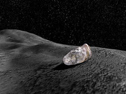
11 Rock Detection in Stereo Images Challenging detection due to arbitrary geometry of rocks 1. Depth gradient provides an indication of obstacles 2. Partial occlusion as additional indicator for obstacle edges 3. Sobel edge detector results in sharp edges at distance jumps Distances can be calculated by triangulation between stereo matches Additional use of laser scanners result in more accurate depth values 11
12 The Virtual Testbed 12


13 Simulated Sensors Sensor simulation in virtual environments Error modeling Sensor data visualization 13


14 Virtual Sensors Algorithmic results and recorded data can be treated as sensors Virtual Sensors are connected in the same manner as real and simulated sensors The combination of real, simulated and virtual sensors is easy Resulting in hybrid testbeds Visual GPS 14

15 Communication Concept Standardized communication using an input output handler Using one abstract base class for all types of transferable data Flexible connection for all kinds of components 15


16 Sensor Framework 16
17 Virtual Testbeds Summary Virtual Testbeds allow a focused view on every component Developing new algorithms is possible without real hardware Conceptual implementation with ideal simulated sensor data Robustness measurement by adding error models Smooth transition between simulated and real world tests Testing with slightly different parameters under constant conditions 17
18 Results and Future Work Results so far: Self Localization method approved in real forestry testbed A mean error of approx. 0.55m was measured by surveyor s office Involved modules and sensors are validated against real components Extrapolation to new environments is possible due to generalized implementation Future Work: New detecting algorithms for extraterrestrial landmarks Navigational map creation from images from landing (Project: FastMap ) Evaluation of self localization results in virtual testbed (Project: SELOK ) Validating new modules for virtual mobile robotics testbeds 18
19 Virtual Testbed for Planetary Exploration 19
IMPROVED MOBILE ROBOT LOCALIZATION USING SEMANTIC WORLD MODELS
 IMPROVED MOBILE ROBOT LOCALIZATION USING SEMANTIC WORLD MODELS Bjoern Sondermann, Markus Emde, and Juergen Rossmann Institute for Man-Machine Interaction, RWTH Aachen University, 52074 Aachen, Germany
Structured light 3D reconstruction
 Structured light 3D reconstruction Reconstruction pipeline and industrial applications rodola@dsi.unive.it 11/05/2010 3D Reconstruction 3D reconstruction is the process of capturing the shape and appearance
3D from Images - Assisted Modeling, Photogrammetry. Marco Callieri ISTI-CNR, Pisa, Italy
 3D from Images - Assisted Modeling, Photogrammetry Marco Callieri ISTI-CNR, Pisa, Italy 3D from Photos Our not-so-secret dream: obtain a reliable and precise 3D from simple photos Why? Easier, cheaper
DEPTH AND GEOMETRY FROM A SINGLE 2D IMAGE USING TRIANGULATION
 2012 IEEE International Conference on Multimedia and Expo Workshops DEPTH AND GEOMETRY FROM A SINGLE 2D IMAGE USING TRIANGULATION Yasir Salih and Aamir S. Malik, Senior Member IEEE Centre for Intelligent
Tecnologie per la ricostruzione di modelli 3D da immagini. Marco Callieri ISTI-CNR, Pisa, Italy
 Tecnologie per la ricostruzione di modelli 3D da immagini Marco Callieri ISTI-CNR, Pisa, Italy Who am I? Marco Callieri PhD in computer science Always had the like for 3D graphics... Researcher at the
Mapping Contoured Terrain Using SLAM with a Radio- Controlled Helicopter Platform. Project Proposal. Cognitive Robotics, Spring 2005
 Mapping Contoured Terrain Using SLAM with a Radio- Controlled Helicopter Platform Project Proposal Cognitive Robotics, Spring 2005 Kaijen Hsiao Henry de Plinval Jason Miller Introduction In the context
Sensor Fusion: Potential, Challenges and Applications. Presented by KVH Industries and Geodetics, Inc. December 2016
 Sensor Fusion: Potential, Challenges and Applications Presented by KVH Industries and Geodetics, Inc. December 2016 1 KVH Industries Overview Innovative technology company 600 employees worldwide Focused
Fundamentals of Stereo Vision Michael Bleyer LVA Stereo Vision
 Fundamentals of Stereo Vision Michael Bleyer LVA Stereo Vision What Happened Last Time? Human 3D perception (3D cinema) Computational stereo Intuitive explanation of what is meant by disparity Stereo matching
On-line and Off-line 3D Reconstruction for Crisis Management Applications
 On-line and Off-line 3D Reconstruction for Crisis Management Applications Geert De Cubber Royal Military Academy, Department of Mechanical Engineering (MSTA) Av. de la Renaissance 30, 1000 Brussels geert.de.cubber@rma.ac.be
Transactions on Information and Communications Technologies vol 16, 1996 WIT Press, ISSN
 ransactions on Information and Communications echnologies vol 6, 996 WI Press, www.witpress.com, ISSN 743-357 Obstacle detection using stereo without correspondence L. X. Zhou & W. K. Gu Institute of Information
Tecnologie per la ricostruzione di modelli 3D da immagini. Marco Callieri ISTI-CNR, Pisa, Italy
 Tecnologie per la ricostruzione di modelli 3D da immagini Marco Callieri ISTI-CNR, Pisa, Italy 3D from Photos Our not-so-secret dream: obtain a reliable and precise 3D from simple photos Why? Easier, less
Localization and Map Building
 Localization and Map Building Noise and aliasing; odometric position estimation To localize or not to localize Belief representation Map representation Probabilistic map-based localization Other examples
3D Point Cloud Processing
 3D Point Cloud Processing The image depicts how our robot Irma3D sees itself in a mirror. The laser looking into itself creates distortions as well as changes in intensity that give the robot a single
NAVIGATION SYSTEM OF AN OUTDOOR SERVICE ROBOT WITH HYBRID LOCOMOTION SYSTEM
 NAVIGATION SYSTEM OF AN OUTDOOR SERVICE ROBOT WITH HYBRID LOCOMOTION SYSTEM Jorma Selkäinaho, Aarne Halme and Janne Paanajärvi Automation Technology Laboratory, Helsinki University of Technology, Espoo,
: Easy 3D Calibration of laser triangulation systems. Fredrik Nilsson Product Manager, SICK, BU Vision
 : Easy 3D Calibration of laser triangulation systems Fredrik Nilsson Product Manager, SICK, BU Vision Using 3D for Machine Vision solutions : 3D imaging is becoming more important and well accepted for
Human Body Recognition and Tracking: How the Kinect Works. Kinect RGB-D Camera. What the Kinect Does. How Kinect Works: Overview
 Human Body Recognition and Tracking: How the Kinect Works Kinect RGB-D Camera Microsoft Kinect (Nov. 2010) Color video camera + laser-projected IR dot pattern + IR camera $120 (April 2012) Kinect 1.5 due
What have we leaned so far?
 What have we leaned so far? Camera structure Eye structure Project 1: High Dynamic Range Imaging What have we learned so far? Image Filtering Image Warping Camera Projection Model Project 2: Panoramic
Camera Registration in a 3D City Model. Min Ding CS294-6 Final Presentation Dec 13, 2006
 Camera Registration in a 3D City Model Min Ding CS294-6 Final Presentation Dec 13, 2006 Goal: Reconstruct 3D city model usable for virtual walk- and fly-throughs Virtual reality Urban planning Simulation
A 3-D Scanner Capturing Range and Color for the Robotics Applications
 J.Haverinen & J.Röning, A 3-D Scanner Capturing Range and Color for the Robotics Applications, 24th Workshop of the AAPR - Applications of 3D-Imaging and Graph-based Modeling, May 25-26, Villach, Carinthia,
Camera Drones Lecture 3 3D data generation
 Camera Drones Lecture 3 3D data generation Ass.Prof. Friedrich Fraundorfer WS 2017 Outline SfM introduction SfM concept Feature matching Camera pose estimation Bundle adjustment Dense matching Data products
Neue Verfahren der Bildverarbeitung auch zur Erfassung von Schäden in Abwasserkanälen?
 Neue Verfahren der Bildverarbeitung auch zur Erfassung von Schäden in Abwasserkanälen? Fraunhofer HHI 13.07.2017 1 Fraunhofer-Gesellschaft Fraunhofer is Europe s largest organization for applied research.
Autonomous Robot Navigation: Using Multiple Semi-supervised Models for Obstacle Detection
 Autonomous Robot Navigation: Using Multiple Semi-supervised Models for Obstacle Detection Adam Bates University of Colorado at Boulder Abstract: This paper proposes a novel approach to efficiently creating
Project 2 due today Project 3 out today. Readings Szeliski, Chapter 10 (through 10.5)
") Announcements Stereo Project 2 due today Project 3 out today Single image stereogram, by Niklas Een Readings Szeliski, Chapter 10 (through 10.5) Public Library, Stereoscopic Looking Room, Chicago, by Phillips,
Announcements Stereo Project 2 due today Project 3 out today Single image stereogram, by Niklas Een Readings Szeliski, Chapter 10 (through 10.5) Public Library, Stereoscopic Looking Room, Chicago, by Phillips,
Accuracy Assessment of Ames Stereo Pipeline Derived DEMs Using a Weighted Spatial Dependence Model
 Accuracy Assessment of Ames Stereo Pipeline Derived DEMs Using a Weighted Spatial Dependence Model Intro Problem Statement A successful lunar mission requires accurate, high resolution data products to
Multiple View Geometry
 Multiple View Geometry CS 6320, Spring 2013 Guest Lecture Marcel Prastawa adapted from Pollefeys, Shah, and Zisserman Single view computer vision Projective actions of cameras Camera callibration Photometric
Large-Scale. Point Cloud Processing Tutorial. Application: Mobile Mapping
 Large-Scale 3D Point Cloud Processing Tutorial 2013 Application: Mobile Mapping The image depicts how our robot Irma3D sees itself in a mirror. The laser looking into itself creates distortions as well
Recent developments in laser scanning
 Recent developments in laser scanning Kourosh Khoshelham With contributions from: Sander Oude Elberink, Guorui Li, Xinwei Fang, Sudan Xu and Lucia Diaz Vilarino Why laser scanning? Laser scanning accurate
Introduction to Autonomous Mobile Robots
 Introduction to Autonomous Mobile Robots second edition Roland Siegwart, Illah R. Nourbakhsh, and Davide Scaramuzza The MIT Press Cambridge, Massachusetts London, England Contents Acknowledgments xiii
Probabilistic Robotics
 Probabilistic Robotics Probabilistic Motion and Sensor Models Some slides adopted from: Wolfram Burgard, Cyrill Stachniss, Maren Bennewitz, Kai Arras and Probabilistic Robotics Book SA-1 Sensors for Mobile
Robotics. Chapter 25. Chapter 25 1
 Robotics Chapter 25 Chapter 25 1 Outline Robots, Effectors, and Sensors Localization and Mapping Motion Planning Chapter 25 2 Mobile Robots Chapter 25 3 Manipulators P R R R R R Configuration of robot
Simultaneous Localization and Mapping (SLAM)
") Simultaneous Localization and Mapping (SLAM) RSS Lecture 16 April 8, 2013 Prof. Teller Text: Siegwart and Nourbakhsh S. 5.8 SLAM Problem Statement Inputs: No external coordinate reference Time series of
Simultaneous Localization and Mapping (SLAM) RSS Lecture 16 April 8, 2013 Prof. Teller Text: Siegwart and Nourbakhsh S. 5.8 SLAM Problem Statement Inputs: No external coordinate reference Time series of
MULTI-MODAL MAPPING. Robotics Day, 31 Mar Frank Mascarich, Shehryar Khattak, Tung Dang
 MULTI-MODAL MAPPING Robotics Day, 31 Mar 2017 Frank Mascarich, Shehryar Khattak, Tung Dang Application-Specific Sensors Cameras TOF Cameras PERCEPTION LiDAR IMU Localization Mapping Autonomy Robotic Perception
TAKING LIDAR SUBSEA. Adam Lowry, Nov 2016
 TAKING LIDAR SUBSEA Adam Lowry, Nov 2016 3D AT DEPTH Based in the technology hub of Boulder, Colorado, 3D at Depth is dedicated to the development of underwater laser measurement sensors and software Patented
L2 Data Acquisition. Mechanical measurement (CMM) Structured light Range images Shape from shading Other methods
 Structured light Range images Shape from shading Other methods") L2 Data Acquisition Mechanical measurement (CMM) Structured light Range images Shape from shading Other methods 1 Coordinate Measurement Machine Touch based Slow Sparse Data Complex planning Accurate 2
L2 Data Acquisition Mechanical measurement (CMM) Structured light Range images Shape from shading Other methods 1 Coordinate Measurement Machine Touch based Slow Sparse Data Complex planning Accurate 2
EVOLUTION OF POINT CLOUD
 Figure 1: Left and right images of a stereo pair and the disparity map (right) showing the differences of each pixel in the right and left image. (source: https://stackoverflow.com/questions/17607312/difference-between-disparity-map-and-disparity-image-in-stereo-matching)
Hybrids Mixed Approaches
 Hybrids Mixed Approaches Stephan Weiss Computer Vision Group NASA-JPL / CalTech Stephan.Weiss@ieee.org (c) 2013. Government sponsorship acknowledged. Outline Why mixing? Parallel Tracking and Mapping Benefits
Davide Scaramuzza. University of Zurich
 Davide Scaramuzza University of Zurich Robotics and Perception Group http://rpg.ifi.uzh.ch/ Scaramuzza, D., Fraundorfer, F., Visual Odometry: Part I - The First 30 Years and Fundamentals, IEEE Robotics
Depth. Common Classification Tasks. Example: AlexNet. Another Example: Inception. Another Example: Inception. Depth
 Common Classification Tasks Recognition of individual objects/faces Analyze object-specific features (e.g., key points) Train with images from different viewing angles Recognition of object classes Analyze
CSE-571 Robotics. Sensors for Mobile Robots. Beam-based Sensor Model. Proximity Sensors. Probabilistic Sensor Models. Beam-based Scan-based Landmarks
 Sensors for Mobile Robots CSE-57 Robotics Probabilistic Sensor Models Beam-based Scan-based Landmarks Contact sensors: Bumpers Internal sensors Accelerometers (spring-mounted masses) Gyroscopes (spinning
Embedded real-time stereo estimation via Semi-Global Matching on the GPU
 Embedded real-time stereo estimation via Semi-Global Matching on the GPU Daniel Hernández Juárez, Alejandro Chacón, Antonio Espinosa, David Vázquez, Juan Carlos Moure and Antonio M. López Computer Architecture
Appearance-based Visual Localisation in Outdoor Environments with an Omnidirectional Camera
 52. Internationales Wissenschaftliches Kolloquium Technische Universität Ilmenau 10. - 13. September 2007 M. Schenderlein / K. Debes / A. Koenig / H.-M. Gross Appearance-based Visual Localisation in Outdoor
LUMS Mine Detector Project
 LUMS Mine Detector Project Using visual information to control a robot (Hutchinson et al. 1996). Vision may or may not be used in the feedback loop. Visual (image based) features such as points, lines
Planetary Rover Absolute Localization by Combining Visual Odometry with Orbital Image Measurements
 Planetary Rover Absolute Localization by Combining Visual Odometry with Orbital Image Measurements M. Lourakis and E. Hourdakis Institute of Computer Science Foundation for Research and Technology Hellas
VISION-BASED PERCEPTION AND SENSOR DATA INTEGRATION FOR A PLANETARY EXPLORATION ROVER
 VISION-BASED PERCEPTION AND SENSOR DATA INTEGRATION FOR A PLANETARY EXPLORATION ROVER Zereik E. 1, Biggio A. 2, Merlo A. 2, and Casalino G. 1 1 DIST, University of Genoa, Via Opera Pia 13, 16145 Genoa,
EE795: Computer Vision and Intelligent Systems
 EE795: Computer Vision and Intelligent Systems Spring 2012 TTh 17:30-18:45 FDH 204 Lecture 14 130307 http://www.ee.unlv.edu/~b1morris/ecg795/ 2 Outline Review Stereo Dense Motion Estimation Translational
Simultaneous Localization
 Simultaneous Localization and Mapping (SLAM) RSS Technical Lecture 16 April 9, 2012 Prof. Teller Text: Siegwart and Nourbakhsh S. 5.8 Navigation Overview Where am I? Where am I going? Localization Assumed
V-Sentinel: A Novel Framework for Situational Awareness and Surveillance
 V-Sentinel: A Novel Framework for Situational Awareness and Surveillance Suya You Integrated Media Systems Center Computer Science Department University of Southern California March 2005 1 Objective Developing
Improving Vision-based Topological Localization by Combining Local and Global Image Features
 Improving Vision-based Topological Localization by Combining Local and Global Image Features Shuai Yang and Han Wang Nanyang Technological University, Singapore Introduction Self-localization is crucial
SL A Tordivel - Thor Vollset -Stereo Vision and structured illumination creates dense 3D Images Page 1
 Tordivel ASTORDIVEL 2000-2015 Scorpion Vision Software Scorpion Stinger are trademarks SL-2010-0001-A AS - Scorpion Visionand 8 and 3DMaMa Tordivel ASof Tordivel AS 2000-2010 Page 1 Stereo Vision and structured
Practical Course WS12/13 Introduction to Monte Carlo Localization
 Practical Course WS12/13 Introduction to Monte Carlo Localization Cyrill Stachniss and Luciano Spinello 1 State Estimation Estimate the state of a system given observations and controls Goal: 2 Bayes Filter
W4. Perception & Situation Awareness & Decision making
 W4. Perception & Situation Awareness & Decision making Robot Perception for Dynamic environments: Outline & DP-Grids concept Dynamic Probabilistic Grids Bayesian Occupancy Filter concept Dynamic Probabilistic
Outline. ETN-FPI Training School on Plenoptic Sensing
 Outline Introduction Part I: Basics of Mathematical Optimization Linear Least Squares Nonlinear Optimization Part II: Basics of Computer Vision Camera Model Multi-Camera Model Multi-Camera Calibration
Trimble Engineering & Construction Group, 5475 Kellenburger Road, Dayton, OH , USA
 Trimble VISION Ken Joyce Martin Koehler Michael Vogel Trimble Engineering and Construction Group Westminster, Colorado, USA April 2012 Trimble Engineering & Construction Group, 5475 Kellenburger Road,
Sensing Deforming and Moving Objects with Commercial Off the Shelf Hardware
 Sensing Deforming and Moving Objects with Commercial Off the Shelf Hardware This work supported by: Philip Fong Florian Buron Stanford University Motivational Applications Human tissue modeling for surgical
A novel 3D torso image reconstruction procedure using a pair of digital stereo back images
 Modelling in Medicine and Biology VIII 257 A novel 3D torso image reconstruction procedure using a pair of digital stereo back images A. Kumar & N. Durdle Department of Electrical & Computer Engineering,
Egomotion Estimation by Point-Cloud Back-Mapping
 Egomotion Estimation by Point-Cloud Back-Mapping Haokun Geng, Radu Nicolescu, and Reinhard Klette Department of Computer Science, University of Auckland, New Zealand hgen001@aucklanduni.ac.nz Abstract.
Stereo vision. Many slides adapted from Steve Seitz
 Stereo vision Many slides adapted from Steve Seitz What is stereo vision? Generic problem formulation: given several images of the same object or scene, compute a representation of its 3D shape What is
Robot Localization based on Geo-referenced Images and G raphic Methods
 Robot Localization based on Geo-referenced Images and G raphic Methods Sid Ahmed Berrabah Mechanical Department, Royal Military School, Belgium, sidahmed.berrabah@rma.ac.be Janusz Bedkowski, Łukasz Lubasiński,
Robotics. Haslum COMP3620/6320
 Robotics P@trik Haslum COMP3620/6320 Introduction Robotics Industrial Automation * Repetitive manipulation tasks (assembly, etc). * Well-known, controlled environment. * High-power, high-precision, very
CS 4495/7495 Computer Vision Frank Dellaert, Fall 07. Dense Stereo Some Slides by Forsyth & Ponce, Jim Rehg, Sing Bing Kang
 CS 4495/7495 Computer Vision Frank Dellaert, Fall 07 Dense Stereo Some Slides by Forsyth & Ponce, Jim Rehg, Sing Bing Kang Etymology Stereo comes from the Greek word for solid (στερεο), and the term can
Dedicated Software Algorithms for 3D Clouds of Points
 Dedicated Software Algorithms for 3D Clouds of Points Introduction AQSENSE develops and commercializes 3D image acquisition and processing technologies that allow high speed in-line 100% production inspection,
Optimizing Monocular Cues for Depth Estimation from Indoor Images
 Optimizing Monocular Cues for Depth Estimation from Indoor Images Aditya Venkatraman 1, Sheetal Mahadik 2 1, 2 Department of Electronics and Telecommunication, ST Francis Institute of Technology, Mumbai,
Computer and Machine Vision
 Computer and Machine Vision Lecture Week 4 Part-2 February 5, 2014 Sam Siewert Outline of Week 4 Practical Methods for Dealing with Camera Streams, Frame by Frame and De-coding/Re-encoding for Analysis
Topological Mobile Robot Localization Using Fast Vision Techniques
 Proceedings of the 2002 IEEE International Conference on Robotics 8 Automation Washington, DC May 2002 Topological Mobile Robot Localization Using Fast Vision Techniques Paul Blaer and Peter Allen Department
CS5670: Computer Vision
 CS5670: Computer Vision Noah Snavely, Zhengqi Li Stereo Single image stereogram, by Niklas Een Mark Twain at Pool Table", no date, UCR Museum of Photography Stereo Given two images from different viewpoints
3D scanning. 3D scanning is a family of technologies created as a means of automatic measurement of geometric properties of objects.
 Acquiring 3D shape 3D scanning 3D scanning is a family of technologies created as a means of automatic measurement of geometric properties of objects. The produced digital model is formed by geometric
Integrating LIDAR into Stereo for Fast and Improved Disparity Computation
 Integrating LIDAR into Stereo for Fast and Improved Computation Hernán Badino, Daniel Huber, and Takeo Kanade Robotics Institute, Carnegie Mellon University Pittsburgh, PA, USA Stereo/LIDAR Integration
Airborne Laser Survey Systems: Technology and Applications
 Abstract Airborne Laser Survey Systems: Technology and Applications Guangping HE Lambda Tech International, Inc. 2323B Blue Mound RD., Waukesha, WI-53186, USA Email: he@lambdatech.com As mapping products
LEARNING KIT AND TUTORIALS FOR THE DIFFUSION OF THE DIGITAL PHOTOGRAMMETRY
 LEARNING KIT AND TUTORIALS FOR THE DIFFUSION OF THE DIGITAL PHOTOGRAMMETRY Elena ALBERY *, Andrea LINGUA *, Paolo MASCHIO * * Politecnico di Torino, Italia Dipartimento di Georisorse e Territorio Albery@vdiget.polito.it,
3DCITY. Spatial Mapping and Holographic Tools for 3D Data Acquisition and Visualization of Underground Infrastructure Networks
 3DCITY Spatial Mapping and Holographic Tools for 3D Data Acquisition and Visualization of Underground Infrastructure Networks CONTENT 1. 3DCITY Project 2. Geolocation 3. Spatial Mapping 4. MR Visualization
Laser Eye a new 3D sensor for active vision
 Laser Eye a new 3D sensor for active vision Piotr Jasiobedzki1, Michael Jenkin2, Evangelos Milios2' Brian Down1, John Tsotsos1, Todd Campbell3 1 Dept. of Computer Science, University of Toronto Toronto,
Stereo Vision A simple system. Dr. Gerhard Roth Winter 2012
 Stereo Vision A simple system Dr. Gerhard Roth Winter 2012 Stereo Stereo Ability to infer information on the 3-D structure and distance of a scene from two or more images taken from different viewpoints
InFuse: A Comprehensive Framework for Data Fusion in Space Robotics
 InFuse InFuse: A Comprehensive Framework for Data Fusion in Space Robotics June 20 th, 2017 Shashank Govindaraj (Space Applications Services, Belgium) Overview 1. Motivations & Objectives 2. InFuse within
CLASSIFICATION OF NONPHOTOGRAPHIC REMOTE SENSORS
 CLASSIFICATION OF NONPHOTOGRAPHIC REMOTE SENSORS PASSIVE ACTIVE DIGITAL CAMERA THERMAL (e.g. TIMS) VIDEO CAMERA MULTI- SPECTRAL SCANNERS VISIBLE & NIR MICROWAVE HYPERSPECTRAL (e.g. AVIRIS) SLAR Real Aperture
Master Automática y Robótica. Técnicas Avanzadas de Vision: Visual Odometry. by Pascual Campoy Computer Vision Group
 Master Automática y Robótica Técnicas Avanzadas de Vision: by Pascual Campoy Computer Vision Group www.vision4uav.eu Centro de Automá
Perception. Autonomous Mobile Robots. Sensors Vision Uncertainties, Line extraction from laser scans. Autonomous Systems Lab. Zürich.
 Autonomous Mobile Robots Localization "Position" Global Map Cognition Environment Model Local Map Path Perception Real World Environment Motion Control Perception Sensors Vision Uncertainties, Line extraction
The Fawkes Robot Software Framework
 Nov 28th 2016 MSL Workshop 2016 The Fawkes Robot Software Framework Software Stack for the RoboCup Logistics League Matthias Löbach Tim Niemueller Carologistics RoboCup participant since 2012 Joint team
Lecture 14: Basic Multi-View Geometry
 Lecture 14: Basic Multi-View Geometry Stereo If I needed to find out how far point is away from me, I could use triangulation and two views scene point image plane optical center (Graphic from Khurram
Measurement of 3D Foot Shape Deformation in Motion
 Measurement of 3D Foot Shape Deformation in Motion Makoto Kimura Masaaki Mochimaru Takeo Kanade Digital Human Research Center National Institute of Advanced Industrial Science and Technology, Japan The
Adaptive Zoom Distance Measuring System of Camera Based on the Ranging of Binocular Vision
 Adaptive Zoom Distance Measuring System of Camera Based on the Ranging of Binocular Vision Zhiyan Zhang 1, Wei Qian 1, Lei Pan 1 & Yanjun Li 1 1 University of Shanghai for Science and Technology, China
A Comparison between Active and Passive 3D Vision Sensors: BumblebeeXB3 and Microsoft Kinect
 A Comparison between Active and Passive 3D Vision Sensors: BumblebeeXB3 and Microsoft Kinect Diana Beltran and Luis Basañez Technical University of Catalonia, Barcelona, Spain {diana.beltran,luis.basanez}@upc.edu
Information page for written examinations at Linköping University TER2
 Information page for written examinations at Linköping University Examination date 2016-08-19 Room (1) TER2 Time 8-12 Course code Exam code Course name Exam name Department Number of questions in the examination
COMP 102: Computers and Computing
 COMP 102: Computers and Computing Lecture 23: Computer Vision Instructor: Kaleem Siddiqi (siddiqi@cim.mcgill.ca) Class web page: www.cim.mcgill.ca/~siddiqi/102.html What is computer vision? Broadly speaking,
ABSTRACT 1. INTRODUCTION
 3D visualization for improved manipulation and mobility in EOD and combat engineering applications Joel Alberts, John Edwards, Josh Johnston, Jeff Ferrin Autonomous Solutions, Inc. 990 North 8000 West,
Towards Autonomous Vehicle. What is an autonomous vehicle? Vehicle driving on its own with zero mistakes How? Using sensors
 7 May 2017 Disclaimer Towards Autonomous Vehicle What is an autonomous vehicle? Vehicle driving on its own with zero mistakes How? Using sensors Why Vision Sensors? Humans use both eyes as main sense
Rigorous Scan Data Adjustment for kinematic LIDAR systems
 Rigorous Scan Data Adjustment for kinematic LIDAR systems Paul Swatschina Riegl Laser Measurement Systems ELMF Amsterdam, The Netherlands 13 November 2013 www.riegl.com Contents why kinematic scan data
Geometry of Multiple views
 1 Geometry of Multiple views CS 554 Computer Vision Pinar Duygulu Bilkent University 2 Multiple views Despite the wealth of information contained in a a photograph, the depth of a scene point along the
DTU Technical Report: ARTTS
 DTU Technical Report: ARTTS Title: Author: Project: Face pose tracking and recognition and 3D cameras Rasmus Larsen ARTTS Date: February 10 th, 2006 Contents Contents...2 Introduction...2 State-of-the
Binocular Stereo Vision. System 6 Introduction Is there a Wedge in this 3D scene?
 System 6 Introduction Is there a Wedge in this 3D scene? Binocular Stereo Vision Data a stereo pair of images! Given two 2D images of an object, how can we reconstruct 3D awareness of it? AV: 3D recognition
LiForest Software White paper. TRGS, 3070 M St., Merced, 93610, Phone , LiForest
 0 LiForest LiForest is a platform to manipulate large LiDAR point clouds and extract useful information specifically for forest applications. It integrates a variety of advanced LiDAR processing algorithms
ME/CS 132: Introduction to Vision-based Robot Navigation! Low-level Image Processing" Larry Matthies"
 ME/CS 132: Introduction to Vision-based Robot Navigation! Low-level Image Processing" Larry Matthies" lhm@jpl.nasa.gov, 818-354-3722" Announcements" First homework grading is done! Second homework is due
DETERMINATION OF CORRESPONDING TRUNKS IN A PAIR OF TERRESTRIAL IMAGES AND AIRBORNE LASER SCANNER DATA
 The Photogrammetric Journal of Finland, 20 (1), 2006 Received 31.7.2006, Accepted 13.11.2006 DETERMINATION OF CORRESPONDING TRUNKS IN A PAIR OF TERRESTRIAL IMAGES AND AIRBORNE LASER SCANNER DATA Olli Jokinen,
Monte Carlo Localization for Mobile Robots
 Monte Carlo Localization for Mobile Robots Frank Dellaert 1, Dieter Fox 2, Wolfram Burgard 3, Sebastian Thrun 4 1 Georgia Institute of Technology 2 University of Washington 3 University of Bonn 4 Carnegie
Evaluating the Performance of a Vehicle Pose Measurement System
 Evaluating the Performance of a Vehicle Pose Measurement System Harry Scott Sandor Szabo National Institute of Standards and Technology Abstract A method is presented for evaluating the performance of
3D Modeling of Objects Using Laser Scanning
 1 3D Modeling of Objects Using Laser Scanning D. Jaya Deepu, LPU University, Punjab, India Email: Jaideepudadi@gmail.com Abstract: In the last few decades, constructing accurate three-dimensional models
Flexible Calibration of a Portable Structured Light System through Surface Plane
 Vol. 34, No. 11 ACTA AUTOMATICA SINICA November, 2008 Flexible Calibration of a Portable Structured Light System through Surface Plane GAO Wei 1 WANG Liang 1 HU Zhan-Yi 1 Abstract For a portable structured
Estimating Camera Position And Posture by Using Feature Landmark Database
 Estimating Camera Position And Posture by Using Feature Landmark Database Motoko Oe 1, Tomokazu Sato 2 and Naokazu Yokoya 2 1 IBM Japan 2 Nara Institute of Science and Technology, Japan Abstract. Estimating
3D Mapping of an Unknown Environment by Cooperatively Mobile Robots. Ashraf S. S. Huwedi
 3D Mapping of an Unknown Environment by Cooperatively Mobile Robots Ashraf S. S. Huwedi 3D Mapping of an Unknown Environment by Cooperatively Mobile Robots Ashraf S. S. Huwedi Garyounis University, Faculty
Construction Progress Management and Interior Work Analysis Using Kinect 3D Image Sensors
 33 rd International Symposium on Automation and Robotics in Construction (ISARC 2016) Construction Progress Management and Interior Work Analysis Using Kinect 3D Image Sensors Kosei Ishida 1 1 School of
Autofocus Systems in Machine Vision. Thomas Schäffler
 Autofocus Systems in Machine Vision Thomas Schäffler Agenda Definition: what is Autofocus (AF) Why do we need AF? Components of an AF system How to check for focus? How to adjust focus? Example system