COSCH KR ontology the basis for a platform recommending 3D and spectral digitisation strategies
|
|
|
- Regina Marsh
- 5 years ago
- Views:
Transcription
1 COSCH KR ontology the basis for a platform recommending 3D and spectral digitisation strategies Stefanie Wefers, Ashish Karmacharya, Frank Boochs i3mainz -Institute for Spatial Information and Surveying Technology, Mainz

 Data processing(e.g., registration) content& quality of digital representations vary Roman vessel (385-400 AD), 8.")
2 Motivation Digital documentation ofch objectsisan interdisciplinary task of CH-, spatial/spectral recording-, IT-, and visualisation experts. Which digitisation strategy is best suitable depends on the CH application(= data usage) CH object parameters(e.g., appearance, size) Digitisation device and method(e.g., measurement principles) Data processing(e.g., registration) content& quality of digital representations vary Roman vessel ( AD), 8.3 m long

 Resolution: lower")
3 Dependency in between of characteristics: resolution and accuracy Context: documentation of a Roman ship wreck Terrestrial Laser Scanning vs. Images (Structure from Motion) Resolution: lower higher
4 Dependency in between of characteristics: resolution and accuracy Context: documentation of a Roman ship wreck Terrestrial Laser Scanning vs. Images (Structure from Motion) Global accuracy: higher lower Asking only for high-quality data is not enough! Which recording strategy is suitable depends on the CH object, CH application, the capabilities of the recording device, and the data processing.
5 Motivation Bridge thegapbetweenthevariousexperts involved in thedigitisation ofch objects through a platform under development which will give recommendations for recording strategies based on the information about the CH objectandtheintendeddatausage. COST Action TD1201: Colour and Space in Cultural Heritage(COSCH) provided theopportunity. It is a multidisciplinary European network of humanists, conservators, and engineers.
6 Idea COSCH develops a web based system so-called COSCH Knowledge Representation Application (COSCH KR App) A user of this web based system would need to provide information about a CH object s/he would like to record, related external influences, and the intended applicationof the digital data. Based on the user s input the platform will give recommendationswhich recording strategy is best suited to fulfil all input requirements.
7 Idea CH experts will benefit from this web based system as they will receive objective recommendations which s/he could use asking technical experts for specific offers. Technical experts will benefit from this web based system as they will receive more specificrequestsfrom CH experts. Furthermore, they could check their own approaches.
8 What is COSCH KR? What is needed to create such a web based system? We have to develop an ontology knowledge model (so-called COSCH Knowledge Representation ). This ontologystructures all necessary knowledge about all decisive factors in the decision making how a physical thing (= CH object) has to be recorded to best fulfil the conditions of the targeted application. The web based system will use this ontology knowledge model. The ontology is expressed in Web Ontology Language (OWL).
9 Strategy What do we need to do to create the COSCH KR ontology? We have to determine the scientific disciplines involved in spatial and spectral recording of CH objects: spectral recording experts, spatial recording experts, CH experts, IT experts. We have to structure the knowledge (define a theoretical superstructure from experiences and empirical data) Starting with the domain specific knowledge and then relate the structured knowledge to each other
10 Strategy Background and basis is the fact that a deterministic relation exists between the requirements of a CH application on spatial, spectral, and visual digital information of a CH object which itself has concrete physical characteristics, and the technical possibilities of the spectral and spatial recording devices. We are developing a domain ontology. Itisa schematicmodelthatwill beusedtoinfer recommendationsat theschema level. Itwill express a theoreticalconceptaboutthedecisionmakingof a technicalexpert choosingthebestsuitablespatialorspectralrecordingstrategy.
11 Strategy What do we need to do to create the COSCH KR ontology? Imagine the ontology being a tree with a trunk and many deliquescing branches. From branch point to branch point the description of a topic is getting more and more detailed. We have to create such a tree each branch at a time
 Most important to create a consistent hierarchical structure are discussions: 1) These discussions focus on specific CH Applications making it more easy for all partners: 1) Spatial Case Study 2)")
12 Strategy How to structure the knowledge? 1) Most important to create a consistent hierarchical structure are discussions: 1) These discussions focus on specific CH Applications making it more easy for all partners: 1) Spatial Case Study 2) Spectral Case Study 2) It was decided to create five main branches: Physical Thing, CH Applications, External Influences, Technologies, Data. 3) E.g. the branch Technologies was split into: Data Processing, Tools, Measurement Principles, Technical Processes. Spatial Case Study other Case Studies Spectral Case Study
13 Strategy Most important are the rules and dependencies which link the five top-level classes and sub-classes.


14 Strategy Most important are the rules and dependencies which link the five top-level classes and sub-classes.

15 Simulation of a GUI Spatial Case Study: Deformation analysis Creation of 3D-models of waterlogged wood to determine and visualisethe spatial differences before and after conservation treatment.
16 CH Object has CH Application of CH Application Deformation analysis Visualisation.. has CH Application Demand of Required Data 1D, 2D, 2.5D, 3D Required Quality
17 CH Object Condition Fragile, Moderately Rigid, Highly Rigid CH Object Shape CH Object has CH Characteristics of Cubic, Rectangular, Oval, Circular, Square CH Object Size Small, Moderate, Big CH Object Quantity is a 3D Shape Small, Moderate, Large CH Object Reflectivity Low, Moderate, High Texture Textured, Non-Textured has CH Application of CH Application Deformation analysis Visualisation.. has CH Application Demand of Required Data 1D, 2D, 2.5D, 3D Required Quality
18 CH Object Condition Fragile, Moderately Rigid, Highly Rigid CH Object Shape CH Object has CH Characteristics of Cubic, Rectangular, Oval, Circular, Square CH Object Size Small, Moderate, Big CH Object Quantity is a 3D Shape Small, Moderate, Large CH Object Reflectivity Low, Moderate, High Texture Textured, Non-Textured represents the shape of the CH object has CH Application of CH Application Deformation analysis Visualisation.. has CH Application Demand of Required Data 1D, 2D, 2.5D, 3D Required Quality
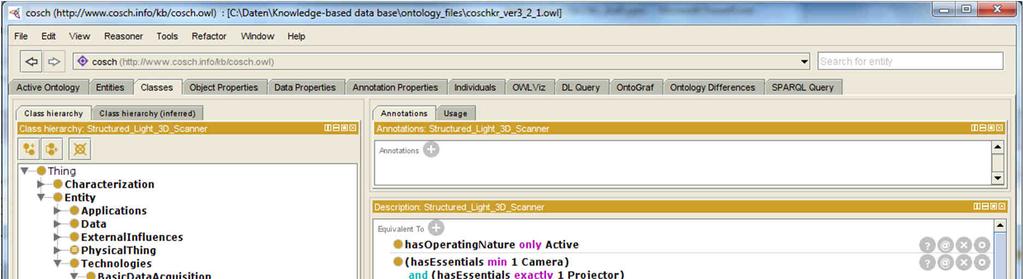
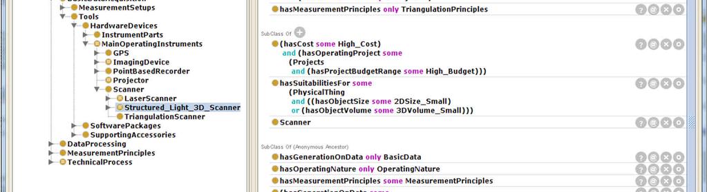
19 CH Object Condition Fragile, Moderately Rigid, Highly Rigid CH Object Shape CH Object has CH Characteristics of Cubic, Rectangular, Oval, Circular, Square CH Object Size Small, Moderate, Big CH Object Quantity Small, Moderate, Large CH Object Reflectivity Low, Moderate, High Texture Textured, Non-Textured represents the shape of the CH object is a 3D Shape Technologies M smnt. Principles Triangulation Angle Measurement Distance Measurement Central Projection Tools Struct. Light Scanner Laser Scanner Camera has CH Application of CH Application Deformation analysis Visualisation.. has CH Application Demand of Required Data 1D, 2D, 2.5D, 3D Required Quality has Generation of Data Processing Feature Matching Technical Process Laser scanning Struct. Light Scanning Struct. from Motion A
20 CH Object Condition Fragile, Moderately Rigid, Highly Rigid CH Object Shape CH Object has CH Characteristics of Cubic, Rectangular, Oval, Circular, Square CH Object Size Small, Moderate, Big CH Object Quantity Small, Moderate, Large CH Object Reflectivity Low, Moderate, High Texture is a 3D Shape Technologies Technical Process Laser scanning Struct. Light Scanning Struct. from Motion Textured, Non-Textured represents the shape of the CH object has CH Application of CH Application Deformation analysis Visualisation.. has CH Application Demand of Required Data 1D, 2D, 2.5D, 3D Required Quality has Generation of
21 CH Object Condition Fragile, Moderately Rigid, Highly Rigid CH Object Shape CH Object has CH Characteristics of Cubic, Rectangular, Oval, Circular, Square CH Object Size Small, Moderate, Big CH Object Quantity Small, Moderate, Large CH Object Reflectivity Low, Moderate, High Texture is a 3D Shape Technologies Technical Process Laser scanning Struct. Light Scanning Struct. from Motion Textured, Non-Textured represents the shape of the CH object has CH Application of CH Application Deformation analysis Visualisation.. has CH Application Demand of Required Data 1D, 2D, 2.5D, 3D Required Quality has Generation of
22 CH Object Condition Fragile, Moderately Rigid, Highly Rigid CH Object Shape CH Object has CH Characteristics of Cubic, Rectangular, Oval, Circular, Square CH Object Size Small, Moderate, Big CH Object Quantity Small, Moderate, Large CH Object Reflectivity Low, Moderate, High Texture is a 3D Shape Technologies Technical Process Laser scanning Struct. Light Scanning Struct. from Motion Textured, Non-Textured represents the shape of the CH object has CH Application of CH Application Deformation analysis Visualisation.. has CH Application Demand of Required Data 1D, 2D, 2.5D, 3D Required Quality has Generation of A
23 CH Object Condition Fragile, Moderately Rigid, Highly Rigid CH Object Shape CH Object has CH Characteristics of Cubic, Rectangular, Oval, Circular, Square CH Object Size Small, Moderate, Big CH Object Quantity Small, Moderate, Large CH Object Reflectivity Low, Moderate, High Texture is a 3D Shape Technologies Technical Process Laser scanning Struct. Light Scanning Struct. from Motion Textured, Non-Textured represents the shape of the CH object has CH Application of CH Application Deformation analysis Visualisation.. has CH Application Demand of Required Data 1D, 2D, 2.5D, 3D Required Quality has Generation of A
24 has CH Application of CH Object CH Application Deformation analysis Visualisation.. has CH Characteristics of has CH Application Demand of CH Object Condition Fragile, Moderately Rigid, Highly Rigid CH Object Shape Cubic, Rectangular, Oval, Circular, Square CH Object Size Small, Moderate, Big CH Object Quantity Small, Moderate, Large CH Object Reflectivity Low, Moderate, High Texture Textured, Non-Textured Required Data 1D, 2D, 2.5D, 3D Required Quality represents the shape of the CH object 3D Shape is a CONFLICT Generates Low Accuracy Technologies Technical Process Laser scanning Struct. Light Scanning Struct. from Motion has Generation of A
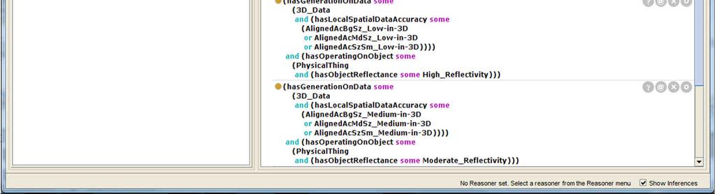
25 CH Object Condition Fragile, Moderately Rigid, Highly Rigid CH Object Shape CH Object has CH Characteristics of Cubic, Rectangular, Oval, Circular, Square CH Object Size Small, Moderate, Big CH Object Quantity Small, Moderate, Large Texture CH Object Reflectivity Low, Moderate, High is a 3D Shape Technologies Technical Process Laser scanning Struct. Light Scanning Struct. from Motion Textured, Non-Textured represents the shape of the CH object has CH Application of CH Application Deformation analysis Visualisation.. has CH Application Demand of Required Data 1D, 2D, 2.5D, 3D Required Quality reducing reflectance, a possibility? has Generation of NO
26 CH Object Condition Fragile, Moderately Rigid, Highly Rigid CH Object Shape CH Object has CH Characteristics of Cubic, Rectangular, Oval, Circular, Square CH Object Size Small, Moderate, Big CH Object Quantity Small, Moderate, Large Texture CH Object Reflectivity Low, Moderate, High is a 3D Shape Technologies Technical Process Laser scanning Struct. Light Scanning Struct. from Motion Textured, Non-Textured represents the shape of the CH object has CH Application of CH Application Deformation analysis Visualisation.. has CH Application Demand of Required Data 1D, 2D, 2.5D, 3D Required Quality reducing reflectance, a possibility? has Generation of YES
27 CH Object Condition Fragile, Moderately Rigid, Highly Rigid CH Object Shape CH Object has CH Characteristics of Cubic, Rectangular, Oval, Circular, Square CH Object Size Small, Moderate, Big CH Object Quantity Small, Moderate, Large CH Object Reflectivity Low, Moderate, High Texture is a 3D Shape Technologies Technical Process Laser scanning Struct. Light Scanning Struct. from Motion Textured, Non-Textured represents the shape of the CH object has CH Application of CH Application Deformation analysis Visualisation.. has CH Application Demand of Required Data 1D, 2D, 2.5D, 3D Required Quality has Generation of A
28 CH Object Condition Fragile, Moderately Rigid, Highly Rigid CH Object Shape CH Object has CH Characteristics of Cubic, Rectangular, Oval, Circular, Square CH Object Size Small, Moderate, Big CH Object Quantity Small, Moderate, Large CH Object Reflectivity Low, Moderate, High Texture is a 3D Shape Technologies Technical Process Laser scanning Struct. Light Scanning Struct. from Motion Textured, Non-Textured represents the shape of the CH object has CH Application of CH Application Deformation analysis Visualisation.. has CH Application Demand of Required Data 1D, 2D, 2.5D, 3D Required Quality has Generation of
29 has Influences from has CH Application of CH Object External Influence (Project) CH Application Deformation analysis Visualisation.. has CH Characteristics of Budget Not Relevant has CH Application Demand of CH Object Condition Fragile, Moderately Rigid, Highly Rigid CH Object Shape Cubic, Rectangular, Oval, Circular, Square CH Object Size Small, Moderate, Big CH Object Quantity Small, Moderate, Large CH Object Reflectivity Low, Moderate, High Texture Textured, Non-Textured Technical Competence Needed Required Data 1D, 2D, 2.5D, 3D Required Quality represents the shape of the CH object Workflow Method Automated, Semi-Automated, Manual has Suitability with 3D Shape is a Technologies Technical Process Laser scanning Struct. Light Scanning Struct. from Motion has Workflow Method has Generation of A
30 CH Object Condition Fragile, Moderately Rigid, Highly Rigid CH Object Shape has Influences from has CH Application of CH Object External Influence (Project) CH Application Deformation analysis Visualisation.. has CH Characteristics of Budget Not Relevant has CH Application Demand of Cubic, Rectangular, Oval, Circular, Square CH Object Size Small, Moderate, Big CH Object Quantity Small, Moderate, Large CH Object Reflectivity Low, Moderate, High Texture Textured, Non-Textured Technical Competence Needed Required Data 1D, 2D, 2.5D, 3D Required Quality represents the shape of the CH object Workflow Method Automated, Semi-Automated, Manual has Suitability with 3D Shape is a Technologies Technical Process Laser scanning Struct. Light Scanning Struct. from Motion has Workflow Method has Generation of
31 CH Object Condition Fragile, Moderately Rigid, Highly Rigid CH Object Shape can only have Markers Internal, External, Natural has Influences from has CH Application of CH Object External Influence (Project) CH Application Deformation analysis Visualisation.. has CH Characteristics of Budget Cubic, Rectangular, Oval, Circular, Square CH Object Size Small, Moderate, Big CH Object Quantity Small, Moderate, Large CH Object Reflectivity Low, Moderate, High Not Relevant has CH Application Demand of Texture Textured, Non-Textured Technical Competence Needed Required Data 1D, 2D, 2.5D, 3D Required Quality represents the shape of the CH object Workflow Method Automated, Semi-Automated, Manual has Suitability with 3D Shape is a Technologies Technical Process Laser scanning Struct. Light Scanning Struct. from Motion has Workflow Method has Generation of
32 CH Object Condition Fragile, Moderately Rigid, Highly Rigid CH Object Shape can only have Markers Internal, External, Natural has Influences from has CH Application of CH Object External Influence (Project) CH Application Deformation analysis Visualisation.. has CH Characteristics of Budget Cubic, Rectangular, Oval, Circular, Square CH Object Size Small, Moderate, Big CH Object Quantity Small, Moderate, Large CH Object Reflectivity Low, Moderate, High Not Relevant has CH Application Demand of Texture Textured, Non-Textured Technical Competence Needed Required Data 1D, 2D, 2.5D, 3D Required Quality Workflow Method Automated, Semi-Automated, Manual has Suitability with 3D Shape is a represents the shape of the CH object CONFLICT Generates Low Accuracy Technologies Technical Process Laser scanning Struct. Light Scanning Struct. from Motion has Workflow Method has Generation of when using A
33 CH Object Condition Fragile, Moderately Rigid, Highly Rigid CH Object Shape can fix Internal Markers? Markers Internal, External, Natural has Influences from has CH Application of CH Object External Influence (Project) CH Application Deformation analysis Visualisation.. has CH Characteristics of Budget Cubic, Rectangular, Oval, Circular, Square CH Object Size Small, Moderate, Big CH Object Quantity Small, Moderate, Large CH Object Reflectivity Low, Moderate, High Not Relevant has CH Application Demand of Texture Textured, Non-Textured Technical Competence Needed Required Data 1D, 2D, 2.5D, 3D Required Quality Workflow Method Automated, Semi-Automated, Manual has Suitability with 3D Shape is a represents the shape of the CH object NO Technologies Technical Process Laser scanning Struct. Light Scanning Struct. from Motion has Workflow Method has Generation of when using
34 CH Object Condition Fragile, Moderately Rigid, Highly Rigid CH Object Shape can fix Internal Markers? Markers Internal, External, Natural has Influences from has CH Application of CH Object External Influence (Project) CH Application Deformation analysis Visualisation.. has CH Characteristics of Budget Cubic, Rectangular, Oval, Circular, Square CH Object Size Small, Moderate, Big CH Object Quantity Small, Moderate, Large CH Object Reflectivity Low, Moderate, High Not Relevant has CH Application Demand of Texture Textured, Non-Textured Technical Competence Needed Required Data 1D, 2D, 2.5D, 3D Required Quality Workflow Method Automated, Semi-Automated, Manual has Suitability with 3D Shape is a represents the shape of the CH object YES Technologies Technical Process Laser scanning Struct. Light Scanning Struct. from Motion has Workflow Method has Generation of when using
35 CH Object Condition Fragile, Moderately Rigid, Highly Rigid CH Object Shape with Markers Internal, External, Natural has Influences from has CH Application of CH Object External Influence (Project) CH Application Deformation analysis Visualisation.. has CH Characteristics of Budget Cubic, Rectangular, Oval, Circular, Square CH Object Size Small, Moderate, Big CH Object Quantity Small, Moderate, Large CH Object Reflectivity Low, Moderate, High Not Relevant has CH Application Demand of Texture Textured, Non-Textured Technical Competence Needed Required Data 1D, 2D, 2.5D, 3D Required Quality Workflow Method Automated, Semi-Automated, Manual has Suitability with 3D Shape is a represents the shape of the CH object Technologies Technical Process Laser scanning Struct. Light Scanning Struct. from Motion has Workflow Method has Generation of when using
36 CH Object Condition Fragile, Moderately Rigid, Highly Rigid CH Object Shape with Markers Internal, External, Natural has Influences from has CH Application of CH Object External Influence (Project) CH Application Deformation analysis Visualisation.. has CH Characteristics of Budget Cubic, Rectangular, Oval, Circular, Square CH Object Size Small, Moderate, Big CH Object Quantity Small, Moderate, Large CH Object Reflectivity Low, Moderate, High Not Relevant has CH Application Demand of Texture Textured, Non-Textured Technical Competence Required Data 1D, 2D, 2.5D, 3D Required Quality Workflow Method Automated, Semi-Automated, Manual has Suitability with 3D Shape is a represents the shape of the CH object Technologies Technical Process Laser scanning Struct. Light Scanning Struct. from Motion has Workflow Method has Generation of when using
37 Status quo and future perspective CH Applications deformation analysis (spatial) and revelation of underdrawing (spectral) operable through the created ontology more than 750 classes Laser Scanning is partially included as an alternative approach Another spectral CH Application will be designed(tatiana PhD topic) Further CH Applicationswill beimplemented(evenafter COSCH) Ontologywill bepublishedin thenearfuture througha front end using a Prolog Inference Mechanism
38 Prolog Inference Mechanism Under development in collaboration with MISANU colleagues from Belgrade COSCH KR ontologyisparsedtoinfer and discover knowledge for optimal recommendations A web service will be developed with an interactive interface (front-end) andcosch KR + inferencemechanism(back-end)
39 Challenges Common understanding: interdisciplinary understanding remote discussions versus face-to-face discussions Discipline habits/methods have to be broken down into logically linked pieces Every single piece has to be named, structured, and linked Example: text > chapter> paragraph> phrase> word> letter
40 In a long-term perspective, theentirech communitywill benefitfromcosch KR platform asdigitisationprojects, whichrelyon COSCH KR recommendations, will bemoresustainableanddurable.
41 Thank you for your attention! Publications: A. Karmacharya, St. Wefers, F. Boochs, Knowledge Based Recommendation on Optimal Spectral and Spatial Recording Strategy of Physical Cultural Heritage Objects. Proceedings Semapro M. Pfarr-Harfst, St. Wefers, Digital 3D reconstructed models Structuring visualisation project workflows. Proceedings EuroMed St. Wefers, A. Karmacharya, F. Boochs, Development of a platform recommending 3D and spectral digitisation strategies. Virtual Archaeology Review 7 (15), A.-K. Wiemann, F. Boochs, A. Karmacharya, St. Wefers, Characterisation of Spatial Techniques for Optimised Use in Cultural Heritage Documentation. In: M. Ioannides et al. (eds.), Digital Heritage. Progress in Cultural Heritage: Documentation, Preservation, and Protection. Proceedings of the 5th International Conference, EuroMed 2014, Limassol, Cyprus, November 3-8, Lecture Notes in Computer Science 8740, in preparation: A. Karmacharya, St. Wefers, Structuring spectral and spatial recording strategies of cultural heritage assets - Background, state of affairs, and future perspectives. COSCH final book. M. Pfarr-Harfst. St. Wefers, F. Boochs, A. Karmacharya, Digital 3D reconstructed models Structuring project workflows using semantic technologies to develop recommendations. Proceedings Conference on Cultural Heritage and New Technologies November 16-18, 2016, Vienna, Austria. planned: Semantic reasoning Spectral case study
42 Inference system through Prolog Ontologies optimal tool for knowledge representation representswhaton a subjectand not HOW Example: Structured Light Scanning is defined through Structured Light Scanner, datait generates, a setup and a data processing this is WHAT BUT there are OTHER number of ways Structured Light Scanning works and they are HOWs. These HOWs are encrypted in COSCH KR within singleclassesthrough rules. Prolog isversedin managing these situation basedhows.
Identification Of the Main 3D Scanning Techniques Suitable for Use in Cultural Heritage Objects
 Identification Of the Main 3D Scanning Techniques Suitable for Use in Cultural Heritage Objects Tobias Reich i3mainz, Institute for Spatial Information and Surveying Technology University of Applied Sciences
Metadata Requirements for Digital Museum Environments
 Metadata Requirements for Digital Museum Environments Manjula Patel UKOLN, University of Bath m.patel@ukoln.ac.uk Unless otherwise stated this work is licensed under a Creative Commons Attribution-ShareAlike
Managing Knowledge for Spatial Data A Case Study with Industrial Archaeological Findings
 Managing Knowledge for Spatial Data A Case Study with Industrial Archaeological Findings Ashish Karmacharya 1,2, Christophe Cruz 2, Frank Boochs 1, Frank Marzani 2 1 Institut i3mainz, am Fachbereich 1
SketchUp. Website:
 SketchUp Email: info@computertraininingwales.co.uk Website: www.computertrainingwales.co.uk SketchUp - Beginner Our one-day SketchUp design courses will give you all the skills you need to move quickly
GABRIELE GUIDI, PHD POLITECNICO DI MILANO, ITALY VISITING SCHOLAR AT INDIANA UNIVERSITY NOV OCT D IMAGE FUSION
 GABRIELE GUIDI, PHD POLITECNICO DI MILANO, ITALY VISITING SCHOLAR AT INDIANA UNIVERSITY NOV 2017 - OCT 2018 3D IMAGE FUSION 3D IMAGE FUSION WHAT A 3D IMAGE IS? A cloud of 3D points collected from a 3D
3D Terrestrial Laser Scanner Innovative Applications for 3D Documentation
 3D Terrestrial Laser Scanner Innovative Applications for 3D Documentation Rodney Chaffee Head of Sales, FARO Asia Pacific 3D Laser Scaning Market 2017 2.3 Billion $ 2012 1.3 Billion $ CAGR : > 12% Source:
TERRESTRIAL LASER SCANNER DATA PROCESSING
 TERRESTRIAL LASER SCANNER DATA PROCESSING L. Bornaz (*), F. Rinaudo (*) (*) Politecnico di Torino - Dipartimento di Georisorse e Territorio C.so Duca degli Abruzzi, 24 10129 Torino Tel. +39.011.564.7687
Post Disaster 3D Modeling of a Collapsed City: Citadel of Bam, Iran
 Post Disaster 3D Modeling of a Collapsed City: Citadel of Bam, Iran Asanobu Kitamoto Elham Andaroodi Mohammad Reza Matini Kinji Ono National Institute of Informatics University of Tehran University of
Geometric and Semantic Matching for Cultural Heritage Artefacts. Stephen C. Phillips IT Innovation
 Geometric and Semantic Matching for Cultural Heritage Artefacts Stephen C. Phillips IT Innovation https://www.flickr.com/photos/lunamodule/ 2 3 4 5 Cracked Faded Eroded Front Back British Museum, London
An Undergraduate Project with Terrestrial Laser Scanner for Purpose of Architectural Survey
 Theory and Application of Laser Scanning ISPRS Summer School 2007 Ljubljana,Slovenia An Undergraduate Project with Terrestrial Laser Scanner for Purpose of Architectural Survey Cemal Özgür KIVILCIM ISPRS
THE COLORED COMPARISON OF THE WALL SCULPTURE WITH 3D LASER SCANNER AND ORTHOPHOTO
 THE COLORED COMPARISON OF THE WALL SCULPTURE WITH 3D LASER SCANNER AND ORTHOPHOTO Hirotoshi KURASHIGE, Jun KATO, Shozo NISHIMURA Creative Department, Keisoku Research Consultant Co, 1-665-1 Fukuda, Higashi-ku,
Training in Mapping Changes on an Archaeological Site
 Training in Mapping Changes on an Archaeological Site Presented at the FIG Congress 2018, May 6-11, 2018 in Istanbul, Turkey Pierre-Yves Gilliéron Bertrand Merminod Jérôme Zufferey EPFL Presentation 04.2015
Automatic image network design leading to optimal image-based 3D models
 Automatic image network design leading to optimal image-based 3D models Enabling laymen to capture high quality 3D models of Cultural Heritage Bashar Alsadik & Markus Gerke, ITC, University of Twente,
Guide to good practice of Reflectance Transformation Imaging: the Roman coins case study A. Mathys, RBINS & RMCA
 Guide to good practice of Reflectance Transformation Imaging: the Roman coins case study A. Mathys, RBINS & RMCA Questions addressed Numerous research questions could be addressed by experts: Can RTI help
CARARE: project overview
 CARARE: project overview Sheena Bassett MDR Partners About Europeana A central point of access to information about digital content thldb held by European cultural l heritage institutions Funded by the
3D MODELING OF CLOSE-RANGE OBJECTS: PHOTOGRAMMETRY OR LASER SCANNING?
 3D MODELING OF CLOSE-RANGE OBJECTS: PHOTOGRAMMETRY OR LASER SCANNING? F. Remondino 1 A. Guarnieri 2 A. Vettore 2 1 Institute of Geodesy and Photogrammetry ETH Hönggerberg - Zurich, Switzerland e-mail:
High Resolution Tree Models: Modeling of a Forest Stand Based on Terrestrial Laser Scanning and Triangulating Scanner Data
 ELMF 2013, 11-13 November 2013 Amsterdam, The Netherlands High Resolution Tree Models: Modeling of a Forest Stand Based on Terrestrial Laser Scanning and Triangulating Scanner Data Lothar Eysn Lothar.Eysn@geo.tuwien.ac.at
ICT-Supported Learning and Training Tools for Terrestrial Laser Scanning Applications
 Professional Education 2009 FIG International Workshop Vienna FIG ICT-Supported Learning and Training Tools for Terrestrial Laser Scanning Applications Erwin Heine, Vienna; Mario Santana Quintero, Bjorn
Combination of non-destructive test methods for damage documentation of monuments
 Combination of non-destructive test methods for damage documentation of monuments Color & Space in Cultural Heritage (COSCH) WG 2: Spatial object documentation Mainz, 27.03.2013 Fraunhofer Institute for
FARO Laser Scanner Focus 3D X330 Demonstration Day
 FARO Laser Scanner Focus 3D X330 Demonstration Day Thursday 7 th November 2013 Precision Measurement Technology New Version SCENE 5.2 - Overview Support for Focus 3D X 330 SCENE WebShare Cloud Integration
Geospatial database for heritage building conservation
 IOP Conf. Series: Earth and Environmental Science 18 (2014) 012087 doi:10.1088/1755-1315/18/1/012087 Geospatial database for heritage building conservation W N F W A Basir1,3, H Setan1, Z M ajid1, A Chong2
Explore Laser Scanning in As-Built Survey. Vijay Chowdhary SE: BIM/CIM
 Explore Laser Scanning in As-Built Survey Vijay Chowdhary SE: BIM/CIM About FARO The world leader in portable 3-D measurement and imaging technology EMEA Headquarters Korntal-Münchingen, Germany APAC Headquarters
ARKive-ERA Project Lessons and Thoughts
 ARKive-ERA Project Lessons and Thoughts Semantic Web for Scientific and Cultural Organisations Convitto della Calza 17 th June 2003 Paul Shabajee (ILRT, University of Bristol) 1 Contents Context Digitisation
Terrestrial 3D laser scanning Practical aspects
 Terrestrial 3D laser scanning Practical aspects ISPRS WG VI/5&SC Summer School 2007 by Gregor Bilban 3D laser scanning Benefits Lower data collection costs Reduction or elimination of re-visits More accurate
Graph-based Guidance in Huge Point Clouds
 Graph-based Guidance in Huge Point Clouds Claus SCHEIBLAUER / Michael WIMMER Institute of Computer Graphics and Algorithms, Vienna University of Technology, Austria Abstract: In recent years the use of
ENGN D Photography / Spring 2018 / SYLLABUS
 ENGN 2502 3D Photography / Spring 2018 / SYLLABUS Description of the proposed course Over the last decade digital photography has entered the mainstream with inexpensive, miniaturized cameras routinely
THE USE OF OPTICAL METHODS FOR LEAK TESTING DAMPERS
 DAAAM INTERNATIONAL SCIENTIFIC BOOK 2013 pp. 787-794 CHAPTER 47 THE USE OF OPTICAL METHODS FOR LEAK TESTING DAMPERS TOMASIAK, J. Abstract: The present paper presents the possible use of a portable structural
Digital Preservation of the Aurelius Church and the Hirsau Museum Complex by Means of HDS and Photogrammetric Texture Mapping
 Master Thesis Ruxandra MOROSAN Ruxandra MOROSAN Digital Preservation of the Aurelius Church and the Hirsau Museum Complex by Means of HDS and Photogrammetric Texture Mapping Duration of the Thesis: 6 months
The Processing of Laser Scan Data for the Analysis of Historic Structures in Ireland
 The 7th International Symposium on Virtual Reality, Archaeology and Cultural Heritage VAST (2006) M. Ioannides, D. Arnold, F. Niccolucci, K. Mania (Editors) The Processing of Laser Scan Data for the Analysis
CE 59700: LASER SCANNING
 Digital Photogrammetry Research Group Lyles School of Civil Engineering Purdue University, USA Webpage: http://purdue.edu/ce/ Email: ahabib@purdue.edu CE 59700: LASER SCANNING 1 Contact Information Instructor:
PROJECT PERIODIC REPORT
 PROJECT PERIODIC REPORT Grant Agreement number: 257403 Project acronym: CUBIST Project title: Combining and Uniting Business Intelligence and Semantic Technologies Funding Scheme: STREP Date of latest
LEARNING KIT AND TUTORIALS FOR THE DIFFUSION OF THE DIGITAL PHOTOGRAMMETRY
 LEARNING KIT AND TUTORIALS FOR THE DIFFUSION OF THE DIGITAL PHOTOGRAMMETRY Elena ALBERY *, Andrea LINGUA *, Paolo MASCHIO * * Politecnico di Torino, Italia Dipartimento di Georisorse e Territorio Albery@vdiget.polito.it,
DIGITAL ARCHIVING IN CULTURAL HERITAGE PRESERVATION
 DIGITAL ARCHIVING IN CULTURAL HERITAGE PRESERVATION HUNG-MING CHENG, YA-NING YEN, WUN-BIN YANG China University of Technology, Taiwan hungmc@cute.edu.tw, alexyen@cute.edu.tw, wunbin@gmail.com Abstract.
Façade Reconstruction An Interactive Image-Based Approach
 Façade Reconstruction An Interactive Image-Based Approach Przemyslaw Musialski Institute of Computer Graphics and Algorithms Vienna University of Technology What is Façade Reconstruction? Part of Urban
Structured light 3D reconstruction
 Structured light 3D reconstruction Reconstruction pipeline and industrial applications rodola@dsi.unive.it 11/05/2010 3D Reconstruction 3D reconstruction is the process of capturing the shape and appearance
Mixed-Reality for Intuitive Photo-Realistic 3D-Model Generation
 Mixed-Reality for Intuitive Photo-Realistic 3D-Model Generation Wolfgang Sepp, Tim Bodenmueller, Michael Suppa, and Gerd Hirzinger DLR, Institut für Robotik und Mechatronik @ GI-Workshop VR/AR 2009 Folie
CoGIP: A Course on 2D Computer Graphics and Image Processing. Eric Paquette, LESIA
 CoGIP: A Course on 2D Computer Graphics and Image Processing Computer Graphics Computer Graphics (CG) 90 % Computer Science curricula 10 % mandatory a vast discipline only a subset in one course Target
Other Reconstruction Techniques
 Other Reconstruction Techniques Ruigang Yang CS 684 CS 684 Spring 2004 1 Taxonomy of Range Sensing From Brain Curless, SIGGRAPH 00 Lecture notes CS 684 Spring 2004 2 Taxonomy of Range Scanning (cont.)
CrossCult Knowledge Base A co-inhabitant of cultural heritage ontology and vocabulary classification
 CrossCult Knowledge Base A co-inhabitant of cultural heritage ontology and vocabulary classification Andreas, Vlachidis, Antonis Bikakis Daphne Kyriaki-Manessi, Ioannis Triantafyllou Angeliki Antoniou
Knowledge Engineering and Data Mining. Knowledge engineering has 6 basic phases:
 Knowledge Engineering and Data Mining Knowledge Engineering The process of building intelligent knowledge based systems is called knowledge engineering Knowledge engineering has 6 basic phases: 1. Problem
GIS Data Collection. This chapter reviews the main methods of GIS data capture and transfer and introduces key practical management issues.
 9 GIS Data Collection OVERVIEW This chapter reviews the main methods of GIS data capture and transfer and introduces key practical management issues. It distinguishes between primary (direct measurement)
ERROR SOURCES IN PROCCESSING LIDAR BASED BRIDGE INSPECTION
 The International Archives of the Photogrammetry, Remote Sensing and Spatial Information Sciences, XLII-/W7, 07 ISPRS Geospatial Week 07, 8 September 07, Wuhan, China ERROR SOURCES IN PROCCESSING LIDAR
3D Laser Scanning Approaches and Business Models for implementing BIM in Facility Management
 3D Laser Scanning Approaches and Business Models for implementing BIM in Facility Management M.Sc. Zsuzsa Besenyői, HTW Berlin Prof. Dr.-Ing. Markus Krämer, HTW Berlin Dipl.-Ing. (FH) Frank Lindner, G2Plus
Highly Accurate Photorealistic Modeling of Cultural Heritage Assets
 Highly Accurate Photorealistic Modeling of Cultural Heritage Assets Peter DORNINGER 1 / Marco BRUNNER 2 1 TU Vienna, Institute of Photogrammetry and Remote Sensing / 2 a:xperience audiovisuelle Kommunikation
Automatic image-based reconstruction of historical buildings from Ayutthaya
 การประช มว ชาการว ศวกรรมโยธาแห งชาต คร งท 20 The 20 tth National Convention on Civil Engineering ว นท 8-10 กรกฎาคม 2558 จ. ชลบ ร 8-10 July 2015, Chonburi, THAILAND Automatic image-based reconstruction
3D SPATIAL DATA ACQUISITION AND MODELING OF ANGHEL SALIGNY MONUMENT USING TERRESTRIAL LASER SCANNING
 JOURNAL OF APPLIED ENGINEERING SCIENCES VOL. 2(15), issue 2_2012 ISSN 2247-3769 ISSN-L 2247-3769 (Print) / e-issn:2284-7197 3D SPATIAL DATA ACQUISITION AND MODELING OF ANGHEL SALIGNY MONUMENT USING TERRESTRIAL
Photogrammetry and 3D Car Navigation
 Photogrammetric Week '07 Dieter Fritsch (Ed.) Wichmann Verlag, Heidelberg, 2007 Strassenburg-Kleciak 309 Photogrammetry and 3D Car Navigation MAREK STRASSENBURG-KLECIAK, Hamburg ABSTRACT The technological
Advanced Highway Maintenance and Construction Technology Research Center
 Advanced Highway Maintenance and Construction Technology Research Center Department of Mechanical and Aerospace Engineering University of California at Davis Creating Standards and Specifications for the
Terminology Management Platform (TMP)
") Terminology Management Platform (TMP) Marie-Véronique Leroi Ministry of Culture and Communication (MCC) France 18 th April 2013 Seminar LH, Paris 1 Outline Context Terminology Management Platform (TMP)
Terminology Management Platform (TMP) Marie-Véronique Leroi Ministry of Culture and Communication (MCC) France 18 th April 2013 Seminar LH, Paris 1 Outline Context Terminology Management Platform (TMP)
Visualisation : Lecture 1. So what is visualisation? Visualisation
 So what is visualisation? UG4 / M.Sc. Course 2006 toby.breckon@ed.ac.uk Computer Vision Lab. Institute for Perception, Action & Behaviour Introducing 1 Application of interactive 3D computer graphics to
Curriculum for the Academy Profession Degree Programme in Multimedia Design & Communication National section. September 2014
 Curriculum for the Academy Profession Degree Programme in Multimedia Design & Communication National section September 2014 1 Table of contents 1. Programme structure... 3 1.1 The programme is regulated
A selection of our previous clients:
 Survey Solutions Geo-Spatial Survey Solutions Ltd Contact: Tel: Email: Y X Roger Davies 07713 160041 roger.davies@geo-spatial.co.uk www.geo-spatial.co.uk A selection of our previous clients: English Heritage
LOW-COST IMAGE BASED SYSTEM FOR NON-TECHNICAL EXPERTS IN CULTURAL HERITAGE DOCUMENTATION AND ANALYSIS
 LOW-COST IMAGE BASED SYSTEM FOR NON-TECHNICAL EXPERTS IN CULTURAL HERITAGE DOCUMENTATION AND ANALYSIS F. Boochs a, G. Heinz b, U. Huxhagen a, H. Müller a a i3mainz, Institute for Spatial Information and
Logik für Informatiker Logic for computer scientists
 Logik für Informatiker for computer scientists WiSe 2011/12 Overview Motivation Why is logic needed in computer science? The LPL book and software Scheinkriterien Why is logic needed in computer science?
DIGITAL REPRESENTATIONS AND ANALYSIS OF DEFORMATIONS INDUCED IN MAP SUPPORTING MATERIALS
 DIGITAL REPRESENTATIONS AND ANALYSIS OF DEFORMATIONS INDUCED IN MAP SUPPORTING MATERIALS A.Adami a, L.Fregonese b, F.Guerra c, E.Livieratos d, V.Tsioukas e a Università IUAV di Venezia, CIRCE, IT [aadami@iuav.it]
Close-Range. Photogrammetry. and 3D Imaging. 2nd edition. Edited by. Thomas Luhmann, Stuart Robson, Stephen Kyle. and Jan Boehm.
 Close-Range Photogrammetry and 3D Imaging 2nd edition Edited by Thomas Luhmann, Stuart Robson, Stephen Kyle and Jan Boehm De Gruyter Content 1 Introduction 1 1.1 Overview 1 1.1.1 Content 1 1.1.2 References
Increasing Productivity/Quality through Better Utilization of Dimensional Data
 Increasing Productivity/Quality through Better Utilization of Dimensional Data By John Reed www.accurexmeasure.com Dimensional measurement is accepted as standard operating procedure Geometric Dimensioning
3D GAMING AND CARTOGRAPHY - DESIGN CONSIDERATIONS FOR GAME-BASED GENERATION OF VIRTUAL TERRAIN ENVIRONMENTS
 3D GAMING AND CARTOGRAPHY - DESIGN CONSIDERATIONS FOR GAME-BASED GENERATION OF VIRTUAL TERRAIN ENVIRONMENTS Abstract Oleggini L. oleggini@karto.baug.ethz.ch Nova S. nova@karto.baug.ethz.ch Hurni L. hurni@karto.baug.ethz.ch
3D Scanning. Lecture courtesy of Szymon Rusinkiewicz Princeton University
 3D Scanning Lecture courtesy of Szymon Rusinkiewicz Princeton University Computer Graphics Pipeline 3D Scanning Shape Motion Rendering Lighting and Reflectance Human time = expensive Sensors = cheap Computer
TERRESTRIAL LASER SCANNING FOR DEFORMATION ANALYSIS
 THALES Project No. 65/1318 TERRESTRIAL LASER SCANNING FOR DEFORMATION ANALYSIS Research Team Maria Tsakiri, Lecturer, NTUA, Greece Artemis Valani, PhD Student, NTUA, Greece 1. INTRODUCTION In this project,
ELEC Dr Reji Mathew Electrical Engineering UNSW
 ELEC 4622 Dr Reji Mathew Electrical Engineering UNSW Review of Motion Modelling and Estimation Introduction to Motion Modelling & Estimation Forward Motion Backward Motion Block Motion Estimation Motion
InfoVis: a semiotic perspective
 InfoVis: a semiotic perspective p based on Semiology of Graphics by J. Bertin Infovis is composed of Representation a mapping from raw data to a visible representation Presentation organizing this visible
HIGH-PERFORMANCE LONG-RANGE LASER SCANNER WITH CALIBRATED DIGITAL CAMERA: A HYBRID 3D LASER SENSOR SYSTEM
 HIGH-PERFORMANCE LONG-RANGE LASER SCANNER WITH CALIBRATED DIGITAL CAMERA: A HYBRID 3D LASER SENSOR SYSTEM ANDREAS ULLRICH Technical Director RIEGL Laser Measurement Systems GmbH Horn, Austria www.riegl.co.at
Simplicity is the new black: The BLK360 story
 Simplicity is the new black: The BLK360 story Vanda KADLECIKOVA Leica Geosystems Heerbrugg, Switzerland E-mail: vanda.kadlecikova@leica-geosystems.com Abstract Meet the game changer. The new Leica BLK360
Integrating Laser Scanning and 3D Capture in Shipbuilding
 Integrating Laser Scanning and 3D Capture in Shipbuilding Jen Rizzo, AVEVA Greg Lawes, point3d www.aveva.com About AVEVA The leading supplier of engineering design and information management software solutions
Integrated High-Quality Acquisition of Geometry and Appearance for Cultural Heritage
 Integrated High-Quality Acquisition of Geometry and Appearance for Cultural Heritage Christopher Schwartz, Michael Weinmann, Roland Ruiters, Reinhard Klein Institute of Computer Science II Computer Graphics
THE ETRUSCANS IN 3D: FROM SPACE TO UNDERGROUND
 THE ETRUSCANS IN 3D: FROM SPACE TO UNDERGROUND Fabio Remondino 1, Alessandro Rizzi 1, Belen Jimenez 1, Giorgio Agugiaro 1, Giorgio Baratti 1, Raffaele De Amicis 2 (1) 3D Optical Metrology (3DOM) Bruno
POINT CLOUD REGISTRATION: CURRENT STATE OF THE SCIENCE. Matthew P. Tait
 POINT CLOUD REGISTRATION: CURRENT STATE OF THE SCIENCE Matthew P. Tait Content 1. Quality control: Analyzing the true errors in Terrestrial Laser Scanning (TLS) 2. The prospects for automatic cloud registration
Enterprise Multimedia Integration and Search
 Enterprise Multimedia Integration and Search José-Manuel López-Cobo 1 and Katharina Siorpaes 1,2 1 playence, Austria, 2 STI Innsbruck, University of Innsbruck, Austria {ozelin.lopez, katharina.siorpaes}@playence.com
LASER SCANNING AND PHOTOGRAMMETRY: A HYBRID APPROACH FOR HERITAGE DOCUMENTATION
 LASER SCANNING AND PHOTOGRAMMETRY: A HYBRID APPROACH FOR HERITAGE DOCUMENTATION Yahya Alshawabkeh, Norbert Haala Institute for Photogrammetry (ifp), University of Stuttgart, Germany Geschwister-Scholl-Strasse
CURRICULUM The Architectural Technology and Construction. programme
 CURRICULUM The Architectural Technology and Construction Management programme CONTENT 1 PROGRAMME STRUCTURE 5 2 CURRICULUM COMMON PART 7 2.1 Core areas in the study programme 7 2.1.1 General 7 2.1.2 Company
Comparison of point clouds captured with terrestrial laser scanners with different technical characteristic
 Comparison of point clouds captured with terrestrial laser scanners with different technical characteristic Janina Zaczek-Peplinska, Maria Elżbieta Kowalska Warsaw University of Technology, Faculty of
Automatic Building Extrusion from a TIN model Using LiDAR and Ordnance Survey Landline Data
 Automatic Building Extrusion from a TIN model Using LiDAR and Ordnance Survey Landline Data Rebecca O.C. Tse, Maciej Dakowicz, Christopher Gold and Dave Kidner University of Glamorgan, Treforest, Mid Glamorgan,
A new geodetic methodology for the accurate Documentation and Monitoring of inaccessible surfaces.
 A new geodetic methodology for the accurate Documentation and Monitoring of inaccessible surfaces. Ε. Lambrou, G. Pantazis Lecturers at NTUA School of Rural and Surveying Engineering National Technical
Computer Science Applications to Cultural Heritage. 3D Reconstruction
 Computer Science Applications to Cultural Heritage 3D Reconstruction Filippo Bergamasco (filippo.bergamasco@unive.it) http://www.dais.unive.it/~bergamasco DAIS, Ca Foscari University of Venice Academic
3D recording of archaeological excavation
 5 th International Conference Remote Sensing in Archaeology The Age of Sensing 13-15 October 2014 - Duke University 3D recording of archaeological excavation Stefano Campana UNIVERSITY of CAMBRIDGE Faculty
Unwrapping of Urban Surface Models
 Unwrapping of Urban Surface Models Generation of virtual city models using laser altimetry and 2D GIS Abstract In this paper we present an approach for the geometric reconstruction of urban areas. It is
Digital Silk Road: Digital Humanities Approach to Spatial Documentation of Cultural Heritage
 Digital Silk Road: Digital Humanities Approach to Spatial Documentation of Cultural Heritage Asanobu KITAMOTO National Institute of Informatics / SOKENDAI http://dsr.nii.ac.jp/bam/ http://dsr.nii.ac.jp/geography/
Using virtual reality to teach history
 Using virtual reality to teach history Calin Neamtu 1, Radu Comes 1, Razvan Mateescu 2, Rares Ghinea 1, Filip Daniel 1 (1) Department of Design Engineering and Robotics, Technical University of Cluj-Napoca,
Robustness analysis of metal forming simulation state of the art in practice. Lectures. S. Wolff
 Lectures Robustness analysis of metal forming simulation state of the art in practice S. Wolff presented at the ICAFT-SFU 2015 Source: www.dynardo.de/en/library Robustness analysis of metal forming simulation
METIS METIS DRS 2000 DCS
 METIS DRS 2000 DCS Specially designed for the Industrial and Decor market, it integrates Metis exclusive DC SynchroLight (Patent protected technology) METIS METIS DC SynchroLight and SuperScan Lighting
Investigating the Structural Condition of Individual Trees using LiDAR Metrics
 Investigating the Structural Condition of Individual Trees using LiDAR Metrics Jon Murray 1, George Alan Blackburn 1, Duncan Whyatt 1, Christopher Edwards 2. 1 Lancaster Environment Centre, Lancaster University,
Two interrelated objectives of the ARIADNE project, are the. Training for Innovation: Data and Multimedia Visualization
 Training for Innovation: Data and Multimedia Visualization Matteo Dellepiane and Roberto Scopigno CNR-ISTI Two interrelated objectives of the ARIADNE project, are the design of new services (or the integration
Software Life-Cycle Models
 Software Life-Cycle Models CMPSC 487 Lecture 03 Topics: UML Class Diagram Rosenburg Chap 2. Domain Modeling A. UML: Unified Modeling Language UML is a general-purpose, developmental, modeling language
Semantic Mapping and Reasoning Approach for Mobile Robotics
 Semantic Mapping and Reasoning Approach for Mobile Robotics Caner GUNEY, Serdar Bora SAYIN, Murat KENDİR, Turkey Key words: Semantic mapping, 3D mapping, probabilistic, robotic surveying, mine surveying
General schedule of the Working Group Meetings
 General schedule of the Working Group Meetings 27.3.2013 Time Event Attendee 8.30 Working group 1 Working group 2 registered persons 10.10 Coffee break 10.30 Working group 4 registered persons 12.10 Lunch
Quality assurance and calibration tasks in the scope of multi-sensor systems
 Quality assurance and calibration tasks in the scope of multi-sensor systems FIG Working Week 2015 From the Wisdom of the Ages to the Challenges of the Modern World Sofia, May 19, 2015 Jens-André Paffenholz,
VISUALIZATION OF FRESCOS BY MEANS OF PHOTOGRAMMETRY AND LASER SCANNING
 VISUALIZATION OF FRESCOS BY MEANS OF PHOTOGRAMMETRY AND LASER SCANNING E. Stylianidis a, P. Patias a, C. Liapakis b, V. Balis b, G. Philotheou c a The Aristotle University of Thessaloniki, Department of
3D Scanning. Qixing Huang Feb. 9 th Slide Credit: Yasutaka Furukawa
 3D Scanning Qixing Huang Feb. 9 th 2017 Slide Credit: Yasutaka Furukawa Geometry Reconstruction Pipeline This Lecture Depth Sensing ICP for Pair-wise Alignment Next Lecture Global Alignment Pairwise Multiple
Increasing Productivity/Quality through Better Utilization of Dimensional Data John Reed, Accurex Measurement, Inc.
 Increasing Productivity/Quality through Better Utilization of Dimensional Data John Reed, Accurex Measurement, Inc. Dimensional measurement is accepted as standard operating procedure in the aerospace
certification.setac.org Certification Contact of Environmental Risk Assessors Phone: certification.setac.
 certification.setac.org Certification Contact Phone: +32 2 772 72 81 Email: CRA@setac.org certification.setac.org of Environmental Risk Assessors The SETAC Europe Certification of Environmental Risk Assessors
Practical experiences towards generic resource navigation and visualization
 Practical experiences towards generic resource navigation and visualization Nadia Catenazzi 1, Lorenzo Sommaruga 2 1 Labi, Varese Italy nadia.catenazzi@tin.it 2 University of Applied Sciences of Southern
Fedora Commons: Taking on the Challenge of the Next Generation of Scholarly Communication
 Fedora Commons: Taking on the Challenge of the Next Generation of Scholarly Communication Sandy Payette Executive Director Fedora Commons November 7, 2007 DLF, Philadelphia, PA Scholarship and Research
Cloth Simulation. Tanja Munz. Master of Science Computer Animation and Visual Effects. CGI Techniques Report
 Cloth Simulation CGI Techniques Report Tanja Munz Master of Science Computer Animation and Visual Effects 21st November, 2014 Abstract Cloth simulation is a wide and popular area of research. First papers
PID System for eresearch
 the European Persistant Identifier Gesellschaft für wissenschaftliche Datenverarbeitung mbh Göttingen Am Fassberg, 37077 Göttingen ulrich.schwardmann@gwdg.de IZA/Gesis/RatSWD-WS Persistent Identifiers
APPLICATION OF SFM AND LASER SCANNING TECHNOLOGY TO THE DESCRIPTION OF MOSAICS PIECE BY PIECE
 APPLICATION OF SFM AND LASER SCANNING TECHNOLOGY TO THE DESCRIPTION OF MOSAICS PIECE BY PIECE O.Ajioka a,b *, Y.Hori a a Dep. of Architecture and Urban Design, Faculty of Human-Environment Studies, Kyushu
3D Modelling Creating Tool for Landscape Design: Camera
 78 Full Paper 3D Modelling Creating Tool for Landscape Design: Camera Ahmet Benliay 1, Isa Eren Akbiyik 2 1 Akdeniz University Faculty of Architecture, Landscape Architecture Department, Antalya/Turkey
Geometric Registration for Deformable Shapes 1.1 Introduction
 Geometric Registration for Deformable Shapes 1.1 Introduction Overview Data Sources and Applications Problem Statement Overview Presenters Will Chang University of California at San Diego, USA Hao Li ETH
ICT & Digital Cinema A new start? Roberto Cencioni. DG Information Society and Media. Unit INFSO.E2 - Content & Knowledge
 ICT & Digital Cinema A new start? Roberto Cencioni DG Information Society and Media Unit INFSO.E2 - Content & Knowledge infso-e2@ec.europa.eu A striking contrast rich tradition of stories and art forms
SCAPE: Shape Completion and Animation of People
 SCAPE: Shape Completion and Animation of People By Dragomir Anguelov, Praveen Srinivasan, Daphne Koller, Sebastian Thrun, Jim Rodgers, James Davis From SIGGRAPH 2005 Presentation for CS468 by Emilio Antúnez