Processing techniques for a GNSS-R scatterometric remote sensing instrument
|
|
|
- Tamsyn Manning
- 5 years ago
- Views:
Transcription
1 Processing techniques for a GNSS-R scatterometric remote sensing instrument Philip J. Jales (1) Martin Unwin (2) Craig Underwood (1) (1) Surrey Space Centre, University Of Surrey, UK (2) Satellite Technology Ltd. (SSTL) October 2010 GNSS-R 2010, Barcelona 1


2 GNSS Reflectometry at Surrey DDM real-time processing GNSS-R stare processing 2


3 GNSS Reflectometry at Surrey UK-DMC GNSS-R experiment SGR-ReSI SSTL instrument development For small satellite / secondary payload Flexible onboard processing architecture Surrey Space Centre Reflectometry PhD 3

: surface roughness scatterometry Primarily ocean")
4 Low cost remote sensor GNSS Reflectometry GNSS signals: Ranging signals, Wide bandwidth, Global coverage Low signal power Measurements around the specular point Information from: Delay: surface height altimetry Distortion (delay and Doppler): surface roughness scatterometry Primarily ocean roughness 4
5 GNSS Reflectometry at Surrey DDM real-time processing GNSS-R stare processing 5

 Delay spread Inversion Doppler spread")

6 GNSS-R Ocean Roughness Primary goal: Surface roughness measurement Surface roughness affects spatial distribution of scattering Measure: Distortion of signal power Delay Doppler Map (DDM) Delay spread Inversion Doppler spread Inversion procedure 'Curve-fit' a scattering model to Delay Doppler Map Models already exist Validation needed currently not enough data 6
7 Onboard processing Limited downlink from satellite Flexibility in processing vs. Data rate Raw samples 65Mbps (two front-ends) DDM 100kbps (2 reflections, 50 Doppler x 128 delay pixels) 7

8 DDM generation approaches Correlation in discrete channels Similar to a navigation, tracking receiver Processing time goes with N Doppler N delay Fourier transform based techniques Parallel calculation of Doppler or delay map 8


9 DDM generation Real-time FPGA architecture Coarse carrier wipe-off Code wipe-off Cascaded- Integrator- Comb Decimator Fourier transform Incoherent accumulation 9

10 Real-time DDM Implementation CIC (Cascaded Integrator-Comb) filter Decimation reduces effort for the frequency search Attenuates signal towards edge of band Optimisation for FPGA implementation Embedded resources more power and space efficient Dual-port RAM blocks & Multipliers Time-sharing (multiple processing clocks per sample) 10

11 Real-time DDM Currently working on live signals Working to demonstrate: Real-time reflection tracking Testing on the data from UK-DMC experiment 11
12 GNSS Reflectometry at Surrey DDM real-time processing GNSS-R stare processing 12
13 Stare processing Based on our interpretation of the SHARP method originally proposed by Starlab, Barcelona Conceptually closer to the monostatic scatterometers currently used for ocean roughness measurement Few published details on SHARP method Has not been demonstrated before 13

14 Scatterometers for measuring ocean roughness Traditionally monostatic (no GPS!) e.g. QuikScat, (measured surface wind vector) Measure normalised radar cross section sigma-0, at 3 incidence angles Semi-empirical model to derive wind speed and direction σ 0 14


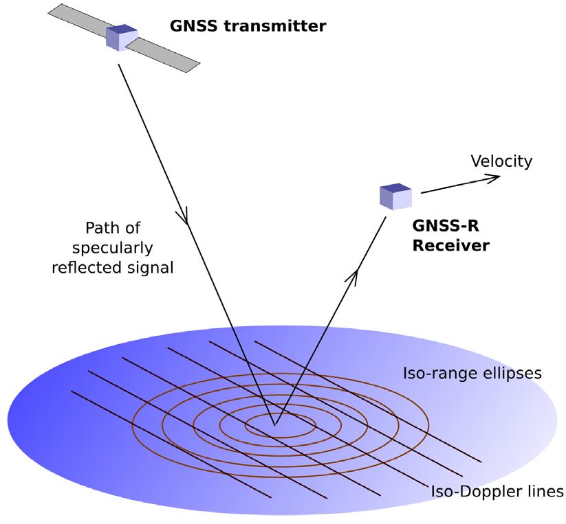


15 GNSS- R The ambiguity-free line Specular point 15

16 Stare processing mode Special case of passing directly over a stare point P 16

17 Correlator-selected area Steer correlator to the delay and Doppler predicted for point P Correlation 'selects' reflected energy from this point The 'illumination' area varies Ocean viewed from above Stare point P on the ambiguity-free line Specular point moves through P Moving Specular Point Ocean viewed from above Stare point P along the ambiguity-free line Specular point moves through P P Fixed stare point t 17

18 Non-ideal geometry Stare point no longer on ambiguity-free line S P Receiver velocity dominates Results in minor reduction in resolution 18
19 Measuring sigma-0 Bistatic radar equation P R = λ P G G σ A 2 T T R ( 4π ) RT RR σ 0 is the scattering crosssection per unit area Variable geometry, transmitter power, and illumination area Geometrical prediction accurate enough? Verify link-budget 19

20 Example DDM demonstrates open-loop tracking DDM processed with open-loop tracking Specular point prediction and tracking demonstrated 20

21 Demonstration on UK-DMC data Processes the 20 second data files 1. Using zenith antenna signals to find the receiver position 2. Predict the reflection position 3. Form stare processing or DDM from nadir samples Software receiver 21
22 Stare processing example: Relative bistatic scattering cross-section Open-loop tracking successful Width of graph expected to give measure of surface roughness 22
23 Conclusions Stare processing Implementation of geometric tracking Verify the accuracy of tracking (using DDM) First demonstration on data collected from space Insufficient data from orbit to build an empirical model Real-time DDM processing Real-time using FPGA optimised structure Receiver operation being validated on UK-DMC data 23

24 Thank you! Any questions? Philip Jales Surrey Space Centre Tycho House 20 Stephenson Road Surrey Research Park Guildford, Surrey, GU2 7YE, U.K. Tel: +44 (0) Ext: 3974 Fax: +44 (0)
GLOBAL navigation satellite system reflectometry
 1064 IEEE GEOCIENCE AND REMOTE ENING LETTER, VOL. 13, NO. 8, AUGUT 2016 On the patial Resolution of GN Reflectometry Maria Paola Clarizia, Member, IEEE, and Christopher. Ruf, Fellow, IEEE Abstract A method
GEOG 4110/5100 Advanced Remote Sensing Lecture 2
 GEOG 4110/5100 Advanced Remote Sensing Lecture 2 Data Quality Radiometric Distortion Radiometric Error Correction Relevant reading: Richards, sections 2.1 2.8; 2.10.1 2.10.3 Data Quality/Resolution Spatial
Motion Compensation in Bistatic Airborne SAR Based on a Geometrical Approach
 SAR Based on a Geometrical Approach Amaya Medrano Ortiz, Holger Nies, Otmar Loffeld Center for Sensorsystems (ZESS) University of Siegen Paul-Bonatz-Str. 9-11 D-57068 Siegen Germany medrano-ortiz@ipp.zess.uni-siegen.de
Empirical transfer function determination by. BP 100, Universit de PARIS 6
 Empirical transfer function determination by the use of Multilayer Perceptron F. Badran b, M. Crepon a, C. Mejia a, S. Thiria a and N. Tran a a Laboratoire d'oc anographie Dynamique et de Climatologie
Do It Yourself 8. Polarization Coherence Tomography (P.C.T) Training Course
 Training Course") Do It Yourself 8 Polarization Coherence Tomography (P.C.T) Training Course 1 Objectives To provide a self taught introduction to Polarization Coherence Tomography (PCT) processing techniques to enable
Do It Yourself 8 Polarization Coherence Tomography (P.C.T) Training Course 1 Objectives To provide a self taught introduction to Polarization Coherence Tomography (PCT) processing techniques to enable
DEVELOPMENT OF ORIENTATION AND DEM/ORTHOIMAGE GENERATION PROGRAM FOR ALOS PRISM
 DEVELOPMENT OF ORIENTATION AND DEM/ORTHOIMAGE GENERATION PROGRAM FOR ALOS PRISM Izumi KAMIYA Geographical Survey Institute 1, Kitasato, Tsukuba 305-0811 Japan Tel: (81)-29-864-5944 Fax: (81)-29-864-2655
Bistatic SAR coherence improvement through spatially variant polarimetry
 1 Bistatic SAR coherence improvement through spatially variant polarimetry By Daniel Andre Centre for Electronic Warfare, Cranfield University, Defence Academy of the United Kingdom, Shrivenham, UK. Abstract
IMAGING WITH SYNTHETIC APERTURE RADAR
 ENGINEERING SCIENCES ; t rical Bngi.net IMAGING WITH SYNTHETIC APERTURE RADAR Didier Massonnet & Jean-Claude Souyris EPFL Press A Swiss academic publisher distributed by CRC Press Table of Contents Acknowledgements
Mission Status and Data Availability: TanDEM-X
 Mission Status and Data Availability: TanDEM-X Irena Hajnsek, Thomas Busche, Alberto Moreira & TanDEM-X Team Microwaves and Radar Institute, German Aerospace Center irena.hajnsek@dlr.de 26-Jan-2009 Outline
CFOSAT and WindRad simulation. IOVWST Meeting Zhen Li, Ad Stoffelen
 CFOSAT and WindRad simulation IOVWST Meeting Zhen Li, Ad Stoffelen 02-05-2017 1 Outline CFOSAT Rotating Fan-beam concept FY-3E WindRad dual frequency Ku/C-band L1B simulation result Beam Weighting method
The Impact of Current and Future Global Navigation Satellite Systems on Precise Carrier Phase Positioning
 The Impact of Current and Future Global Navigation Satellite Systems on Precise Carrier Phase Positioning R.Murat Demirer R.Murat Demirer( CORS Project) 1 Potential Applications of the Global Positioning
Digital Processing of Synthetic Aperture Radar Data
 Digital Processing of Synthetic Aperture Radar Data Algorithms and Implementation Ian G. Cumming Frank H. Wong ARTECH HOUSE BOSTON LONDON artechhouse.com Contents Foreword Preface Acknowledgments xix xxiii
HFSS Hybrid Finite Element and Integral Equation Solver for Large Scale Electromagnetic Design and Simulation
 HFSS Hybrid Finite Element and Integral Equation Solver for Large Scale Electromagnetic Design and Simulation Laila Salman, PhD Technical Services Specialist laila.salman@ansys.com 1 Agenda Overview of
3 - SYNTHETIC APERTURE RADAR (SAR) SUMMARY David Sandwell, SIO 239, January, 2008
 SUMMARY David Sandwell, SIO 239, January, 2008") 1 3 - SYNTHETIC APERTURE RADAR (SAR) SUMMARY David Sandwell, SIO 239, January, 2008 Fraunhoffer diffraction To understand why a synthetic aperture in needed for microwave remote sensing from orbital altitude
1 3 - SYNTHETIC APERTURE RADAR (SAR) SUMMARY David Sandwell, SIO 239, January, 2008 Fraunhoffer diffraction To understand why a synthetic aperture in needed for microwave remote sensing from orbital altitude
Background and Accuracy Analysis of the Xfactor7 Table: Final Report on QuikScat X Factor Accuracy
 Brigham Young University Department of Electrical and Computer Engineering 9 Clyde Building Provo, Utah 86 Background and Accuracy Analysis of the Xfactor7 Table: Final Report on QuikScat X Factor Accuracy
'Smartphone satellite' developed by Surrey space researchers
 Press Release 24th January 2011 'Smartphone satellite' developed by Surrey space researchers Space researchers at the University of Surrey and Surrey Satellite Technology Limited (SSTL) have developed
New Results on the Omega-K Algorithm for Processing Synthetic Aperture Radar Data
 New Results on the Omega-K Algorithm for Processing Synthetic Aperture Radar Data Matthew A. Tolman and David G. Long Electrical and Computer Engineering Dept. Brigham Young University, 459 CB, Provo,
Memorandum. Clint Slatton Prof. Brian Evans Term project idea for Multidimensional Signal Processing (EE381k)
") Memorandum From: To: Subject: Date : Clint Slatton Prof. Brian Evans Term project idea for Multidimensional Signal Processing (EE381k) 16-Sep-98 Project title: Minimizing segmentation discontinuities in
Memorandum From: To: Subject: Date : Clint Slatton Prof. Brian Evans Term project idea for Multidimensional Signal Processing (EE381k) 16-Sep-98 Project title: Minimizing segmentation discontinuities in
GEOG 4110/5100 Advanced Remote Sensing Lecture 4
 GEOG 4110/5100 Advanced Remote Sensing Lecture 4 Geometric Distortion Relevant Reading: Richards, Sections 2.11-2.17 Review What factors influence radiometric distortion? What is striping in an image?
DEVELOPMENT OF A TOOL FOR OFFSHORE WIND RESOURCE ASSESSMENT FOR WIND INDUSTRY
 DEVELOPMENT OF A TOOL FOR OFFSHORE WIND RESOURCE ASSESSMENT FOR WIND INDUSTRY Alberto Rabaneda Dr. Matthew Stickland University of Strathclyde Mechanical and Aerospace Engineering Department Wind resource
Sentinel-1 Toolbox. TOPS Interferometry Tutorial Issued May 2014
 Sentinel-1 Toolbox TOPS Interferometry Tutorial Issued May 2014 Copyright 2015 Array Systems Computing Inc. http://www.array.ca/ https://sentinel.esa.int/web/sentinel/toolboxes Interferometry Tutorial
Terrain correction. Backward geocoding. Terrain correction and ortho-rectification. Why geometric terrain correction? Rüdiger Gens
 Terrain correction and ortho-rectification Terrain correction Rüdiger Gens Why geometric terrain correction? Backward geocoding remove effects of side looking geometry of SAR images necessary step to allow
A MATLAB PHYSICAL OPTICS RCS PREDICTION CODE
 A MATLAB PHYSICAL OPTICS RCS PREDICTION CODE Elmo E. Garrido, Jr. and David C. Jenn Naval Postgraduate School Monterey, CA 93943 SUMMARY POFACETS is an implementation of the physical optics approximation
PSI Precision, accuracy and validation aspects
 PSI Precision, accuracy and validation aspects Urs Wegmüller Charles Werner Gamma Remote Sensing AG, Gümligen, Switzerland, wegmuller@gamma-rs.ch Contents Aim is to obtain a deeper understanding of what
The SMOS ocean salinity retrieval algorithm
 Microrad 2008, Firenze, 11-14 March 2008 The SMOS ocean salinity retrieval algorithm J. Font, J. Boutin, N. Reul, P. Waldteufel, C. Gabarró, S. Zine, J. Tenerelli, M. Talone, F. Petitcolin, J.L. Vergely,
Multistatic SAR Algorithm with Image Combination
 Multistatic SAR Algorithm with Image Combination Tommy Teer and Nathan A. Goodman Department of Electrical and Computer Engineering, The University of Arizona 13 E. Speedway Blvd., Tucson, AZ 8571-14 Phone:
A New Method for Correcting ScanSAR Scalloping Using Forests and inter SCAN Banding Employing Dynamic Filtering
 A New Method for Correcting ScanSAR Scalloping Using Forests and inter SCAN Banding Employing Dynamic Filtering Masanobu Shimada Japan Aerospace Exploration Agency (JAXA), Earth Observation Research Center
Design, Implementation and Performance Evaluation of Synthetic Aperture Radar Signal Processor on FPGAs
 Design, Implementation and Performance Evaluation of Synthetic Aperture Radar Signal Processor on FPGAs Hemang Parekh Masters Thesis MS(Computer Engineering) University of Kansas 23rd June, 2000 Committee:
Imperfections and Errors (Chapter 6)
") Imperfections and Errors (Chapter 6) EC4630 Radar and Laser Cross Section Fall 011 Prof. D. Jenn jenn@nps.navy.mil www.nps.navy.mil/jenn AY011 1 Imperfections and Errors Imperfections and errors are deviations
Imperfections and Errors (Chapter 6) EC4630 Radar and Laser Cross Section Fall 011 Prof. D. Jenn jenn@nps.navy.mil www.nps.navy.mil/jenn AY011 1 Imperfections and Errors Imperfections and errors are deviations
Upcoming altimeter measurements : nadir altimetry from Ku/C to Ka-band, SAR mode, interferometric SAR
 Upcoming altimeter measurements : nadir altimetry from Ku/C to Ka-band, SAR mode, interferometric SAR Jean-Claude Souyris CNES, Service Altimétrie & Radar Acknowledgments : Nathalie Steunou, Roger Fjortoft,
The Staggered SAR Concept: Imaging a Wide Continuous Swath with High Resolution
 The Staggered SAR Concept: Imaging a Wide Continuous Swath with High Resolution Michelangelo Villano *, Gerhard Krieger *, Alberto Moreira * * German Aerospace Center (DLR), Microwaves and Radar Institute
Recent advances in aerospace inspection with ultrasonic phased arrays
 Recent advances in aerospace inspection with ultrasonic phased arrays David Lines Chief Engineer, Diagnostic Sonar Ltd., UK AeroNDT SEMINAR, Aerospace Testing Expo2007 27 th -29 th March 2007, Munich Content
Combination of GNSS and InSAR for Future Australian Datums
 Combination of GNSS and InSAR for Future Australian Datums Thomas Fuhrmann, Matt Garthwaite, Sarah Lawrie, Nick Brown Interferometric Synthetic Aperture Radar Motivation Current situation Static Datum:
Interferometric processing. Rüdiger Gens
 Rüdiger Gens Why InSAR processing? extracting three-dimensional information out of a radar image pair covering the same area digital elevation model change detection 2 Processing chain 3 Processing chain
A Correlation Test: What were the interferometric observation conditions?
 A Correlation Test: What were the interferometric observation conditions? Correlation in Practical Systems For Single-Pass Two-Aperture Interferometer Systems System noise and baseline/volumetric decorrelation
SAR Interferometry. Dr. Rudi Gens. Alaska SAR Facility
 SAR Interferometry Dr. Rudi Gens Alaska SAR Facility 2 Outline! Relevant terms! Geometry! What does InSAR do?! Why does InSAR work?! Processing chain " Data sets " Coregistration " Interferogram generation
Sentinel-1 Toolbox. Interferometry Tutorial Issued March 2015 Updated August Luis Veci
 Sentinel-1 Toolbox Interferometry Tutorial Issued March 2015 Updated August 2016 Luis Veci Copyright 2015 Array Systems Computing Inc. http://www.array.ca/ http://step.esa.int Interferometry Tutorial The
DERIVATION of the BACKSCATTERING COEFFICIENT σ o in ESA ERS SAR PRI PRODUCTS
 ERS SAR CALIBRATION DERIVATION of the BACKSCATTERING COEFFICIENT σ o in ESA ERS SAR PRI PRODUCTS H. Laur 1, P. Bally 2, P. Meadows 3, J. Sanchez 4, B. Schaettler 5, E. Lopinto 6, D. Esteban 4 Document
Near Real-Time Maritime Object Recognition using Multiple SAR Satellite Sensors
 Near Real-Time Maritime Object Recognition using Multiple SAR Satellite Sensors Björn Tings, Domenico Velotto, Sergey Voinov, Andrey Pleskachevsky, Sven Jacobsen German Aerospace Center (DLR) PORSEC 2016
Scattering Properties of Electromagnetic Waves in Stratified air/vegetation/soil and air/snow/ice media : Modeling and Sensitivity Analysis!
 Scattering Properties of Electromagnetic Waves in Stratified air/vegetation/soil and air/snow/ice media : Modeling and Sensitivity Analysis! M. Dechambre et al., LATMOS/IPSL, Université de Versailles 1
Workhorse ADCP Multi- Directional Wave Gauge Primer
 Acoustic Doppler Solutions Workhorse ADCP Multi- Directional Wave Gauge Primer Brandon Strong October, 2000 Principles of ADCP Wave Measurement The basic principle behind wave the measurement, is that
Interferometry Tutorial with RADARSAT-2 Issued March 2014 Last Update November 2017
 Sentinel-1 Toolbox with RADARSAT-2 Issued March 2014 Last Update November 2017 Luis Veci Copyright 2015 Array Systems Computing Inc. http://www.array.ca/ http://step.esa.int with RADARSAT-2 The goal of
High Resolution Imaging by Wave Equation Reflectivity Inversion
 High Resolution Imaging by Wave Equation Reflectivity Inversion A. Valenciano* (Petroleum Geo-Services), S. Lu (Petroleum Geo-Services), N. Chemingui (Petroleum Geo-Services) & J. Yang (University of Houston)
Modeling the Effects of Wind Turbines on Radar Returns
 Modeling the Effects of Wind Turbines on Radar Returns R. Ryan Ohs, Gregory J. Skidmore, Dr. Gary Bedrosian Remcom, Inc. State College, PA USA Abstract Wind turbines located near radar installations can
ALOS PALSAR. Orthorectification Tutorial Issued March 2015 Updated August Luis Veci
 ALOS PALSAR Orthorectification Tutorial Issued March 2015 Updated August 2016 Luis Veci Copyright 2015 Array Systems Computing Inc. http://www.array.ca/ http://step.esa.int ALOS PALSAR Orthorectification
ABSORBER FOAM CHARACTERIZATION FOR PREDICTING OVERALL ANECHOIC CHAMBER PERFORMANCE
 ABSORBER FOAM CHARACTERIZATION FOR PREDICTING OVERALL ANECHOIC CHAMBER PERFORMANCE Christopher R. Brito Lockheed Martin 1111 Lockheed Martin Way, Sunnyvale, CA 94089 Aloysius Aragon Lubiano Raytheon, 2000
DEVELOPMENT OF A NOVEL MICROWAVE RADAR SYSTEM USING ANGULAR CORRELATION FOR THE DETECTION OF BURIED OBJECTS IN SANDY SOILS
 DEVELOPMENT OF A NOVEL MICROWAVE RADAR SYSTEM USING ANGULAR CORRELATION FOR THE DETECTION OF BURIED OBJECTS IN SANDY SOILS Leung Tsang Department of Electrical Engineering University of Washington Box
Heath Yardley University of Adelaide Radar Research Centre
 Heath Yardley University of Adelaide Radar Research Centre Radar Parameters Imaging Geometry Imaging Algorithm Gamma Remote Sensing Modular SAR Processor (MSP) Motion Compensation (MoCom) Calibration Polarimetric
D&S Technical Note 09-2 D&S A Proposed Correction to Reflectance Measurements of Profiled Surfaces. Introduction
 Devices & Services Company 10290 Monroe Drive, Suite 202 - Dallas, Texas 75229 USA - Tel. 214-902-8337 - Fax 214-902-8303 Web: www.devicesandservices.com Email: sales@devicesandservices.com D&S Technical
Commercial Partnerships for Exploration: Making Small Lunar Missions Viable
 Commercial Partnerships for Exploration: Making Small Lunar Missions Viable S.Jason 1, C. Saunders 1, J. Friend 1, M.Cosby 2, J.Carpenter 3, B.Hufenbach 3 V.La Regina 3, M.Sweeting 4 1. Surrey Satellite
Scene Modeling from Motion-Free Radar Sensing
 Scene Modeling from Motion-Free Radar Sensing Alex Foessel Robotics Institute Carnegie Mellon University Ph.D. Thesis Proposal May 13, 1999 Motivation - 2 - Presentation I. Research on Radar for Robots
SPARSE REPRESENTATION AND AUTOFOCUS FOR ISAR AND SPOTLIGHT SAR IMAGING
 SAR 2012 SPARSE REPRESENTATION AND AUTOFOCUS FOR ISAR AND SPOTLIGHT SAR IMAGING February 2012, UCLA Joachim Ender DIrector of the Fraunhofer-Institute for High Frequency Physics and Radar Techniques FHR,
Quantifying the Dynamic Ocean Surface Using Underwater Radiometric Measurement
 DISTRIBUTION STATEMENT A. Approved for public release; distribution is unlimited. Quantifying the Dynamic Ocean Surface Using Underwater Radiometric Measurement Lian Shen Department of Mechanical Engineering
Individual Interferograms to Stacks
 Individual Interferograms to Stacks Piyush Agram Jet Propulsion Laboratory Aug 1, 2016 @UNAVCO Thanks to my colleagues from JPL, Caltech, Stanford University and from all over the world for providing images
Plane Wave Imaging Using Phased Array Arno Volker 1
 11th European Conference on Non-Destructive Testing (ECNDT 2014), October 6-10, 2014, Prague, Czech Republic More Info at Open Access Database www.ndt.net/?id=16409 Plane Wave Imaging Using Phased Array
Simulation of Brightness Temperatures for the Microwave Radiometer (MWR) on the Aquarius/SAC-D Mission. Salman S. Khan M.S. Defense 8 th July, 2009
 on the Aquarius/SAC-D Mission. Salman S. Khan M.S. Defense 8 th July, 2009") Simulation of Brightness Temperatures for the Microwave Radiometer (MWR) on the Aquarius/SAC-D Mission Salman S. Khan M.S. Defense 8 th July, 2009 Outline Thesis Objective Aquarius Salinity Measurements
Simulation of Brightness Temperatures for the Microwave Radiometer (MWR) on the Aquarius/SAC-D Mission Salman S. Khan M.S. Defense 8 th July, 2009 Outline Thesis Objective Aquarius Salinity Measurements
Calibration of IRS-1C PAN-camera
 Calibration of IRS-1C PAN-camera Karsten Jacobsen Institute for Photogrammetry and Engineering Surveys University of Hannover Germany Tel 0049 511 762 2485 Fax -2483 Email karsten@ipi.uni-hannover.de 1.
ASCAT Verification, Calibration & Validation Plan
 ASCAT Verification, Calibration & Validation Plan Doc.No. Issue : : EUM/MET/TEN/11/0187 v1c EUMETSAT Eumetsat-Allee 1, D-64295 Darmstadt, Germany Tel: +49 6151 807-7 Fax: +49 6151 807 555 Date : 9 June
SEA SURFACE SPEED FROM TERRASAR-X ATI DATA
 SEA SURFACE SPEED FROM TERRASAR-X ATI DATA Matteo Soccorsi (1) and Susanne Lehner (1) (1) German Aerospace Center, Remote Sensing Technology Institute, 82234 Weßling, Germany, Email: matteo.soccorsi@dlr.de
Synthetic Aperture Radar Modeling using MATLAB and Simulink
 Synthetic Aperture Radar Modeling using MATLAB and Simulink Naivedya Mishra Team Lead Uurmi Systems Pvt. Ltd. Hyderabad Agenda What is Synthetic Aperture Radar? SAR Imaging Process Challenges in Design
TANDEM-X: DEM ACQUISITION IN THE THIRD YEAR ERA
 TANDEM-X: DEM ACQUISITION IN THE THIRD YEAR ERA D. Borla Tridon, M. Bachmann, D. Schulze, C. J. Ortega Miguez, M. D. Polimeni, M. Martone and TanDEM-X Team Microwaves and Radar Institute, DLR 5 th International
A Comprehensive Model for Performance Prediction of Electro-Optical Systems
 A Comprehensive Model for Performance Prediction of Electro-Optical Systems Joseph J. Shirron and Thomas E. Giddings Metron, Inc. Suite 800, 11911 Freedom Drive Reston, VA 20190 phone: (703) 787-8700 fax:
CHAPTER 5 GLOBAL AND LOCAL FEATURES FOR FACE RECOGNITION
 122 CHAPTER 5 GLOBAL AND LOCAL FEATURES FOR FACE RECOGNITION 5.1 INTRODUCTION Face recognition, means checking for the presence of a face from a database that contains many faces and could be performed
FIRST RESULTS OF THE ALOS PALSAR VERIFICATION PROCESSOR
 FIRST RESULTS OF THE ALOS PALSAR VERIFICATION PROCESSOR P. Pasquali (1), A. Monti Guarnieri (2), D. D Aria (3), L. Costa (3), D. Small (4), M. Jehle (4) and B. Rosich (5) (1) sarmap s.a., Cascine di Barico,
Hydrological network detection for SWOT data. S. Lobry, F. Cao, R. Fjortoft, JM Nicolas, F. Tupin
 Hydrological network detection for SWOT data S. Lobry, F. Cao, R. Fjortoft, JM Nicolas, F. Tupin IRS SPU avril 2016 SWOT mission Large water bodies detection Fine network detection Further works page 1
2017 Summer Course on Optical Oceanography and Ocean Color Remote Sensing. Introduction to Remote Sensing
 2017 Summer Course on Optical Oceanography and Ocean Color Remote Sensing Introduction to Remote Sensing Curtis Mobley Delivered at the Darling Marine Center, University of Maine July 2017 Copyright 2017
A real time SAR processor implementation with FPGA
 Computational Methods and Experimental Measurements XV 435 A real time SAR processor implementation with FPGA C. Lesnik, A. Kawalec & P. Serafin Institute of Radioelectronics, Military University of Technology,
then assume that we are given the image of one of these textures captured by a camera at a different (longer) distance and with unknown direction of i
 distance and with unknown direction of i") Image Texture Prediction using Colour Photometric Stereo Xavier Lladó 1, Joan Mart 1, and Maria Petrou 2 1 Institute of Informatics and Applications, University of Girona, 1771, Girona, Spain fllado,joanmg@eia.udg.es
Image Texture Prediction using Colour Photometric Stereo Xavier Lladó 1, Joan Mart 1, and Maria Petrou 2 1 Institute of Informatics and Applications, University of Girona, 1771, Girona, Spain fllado,joanmg@eia.udg.es
Analysis Ready Data For Land
 Analysis Ready Data For Land Product Family Specification Optical Surface Reflectance (CARD4L-OSR) Document status For Adoption as: Product Family Specification, Surface Reflectance, Working Draft (2017)
Image Processing Fundamentals. Nicolas Vazquez Principal Software Engineer National Instruments
 Image Processing Fundamentals Nicolas Vazquez Principal Software Engineer National Instruments Agenda Objectives and Motivations Enhancing Images Checking for Presence Locating Parts Measuring Features
Measuring Ground Deformation using Optical Imagery
 Measuring Ground Deformation using Optical Imagery Sébastien Leprince California Institute of Technology, USA October 29, 2009 Keck Institute for Space Studies Workshop Measuring Horizontal Ground Displacement,
Technical Manual SATGEN II SATELLITE DATA GENERATION PROGRAM. Document M Revision 1.0 April dbm. 32A Spruce Street Oakland, NJ 07436
 Technical Manual SATGEN II SATELLITE DATA GENERATION PROGRAM Document M2001322 Revision 1.0 April 2011 dbm 32A Spruce Street Oakland, NJ 07436 Phone 201-677-0008 FAX 201-667-9444 1 Table of Contents Contents
PolSARpro v4.03 Forest Applications
 PolSARpro v4.03 Forest Applications Laurent Ferro-Famil Lecture on polarimetric SAR Theory and applications to agriculture & vegetation Thursday 19 April, morning Pol-InSAR Tutorial Forest Application
A SPECTRAL ANALYSIS OF SINGLE ANTENNA INTERFEROMETRY. Craig Stringham
 A SPECTRAL ANALYSIS OF SINGLE ANTENNA INTERFEROMETRY Craig Stringham Microwave Earth Remote Sensing Laboratory Brigham Young University 459 CB, Provo, UT 84602 March 18, 2013 ABSTRACT This paper analyzes
Analysis of Urban Areas Scattering with Simulated SAR Imagery
 Analysis of Urban Areas Scattering with Simulated SAR Imagery G. Margarit, J. J. Mallorquí, I. Corney, L. Pipia, C. López-Martínez, X. Fàbregas, A. Aguasca mallorqui@tsc.upc.edu Remote Sensing Laboratory
AMBIGUOUS PSI MEASUREMENTS
 AMBIGUOUS PSI MEASUREMENTS J. Duro (1), N. Miranda (1), G. Cooksley (1), E. Biescas (1), A. Arnaud (1) (1). Altamira Information, C/ Còrcega 381 387, 2n 3a, E 8037 Barcelona, Spain, Email: javier.duro@altamira
COMPUTER SIMULATION TECHNIQUES FOR ACOUSTICAL DESIGN OF ROOMS - HOW TO TREAT REFLECTIONS IN SOUND FIELD SIMULATION
 J.H. Rindel, Computer simulation techniques for the acoustical design of rooms - how to treat reflections in sound field simulation. ASVA 97, Tokyo, 2-4 April 1997. Proceedings p. 201-208. COMPUTER SIMULATION
Simulation and Analysis of an Earth Observation Mission Based on Agile Platform
 Simulation and Analysis of an Earth Observation Mission Based on Agile Platform Augusto Caramagno Fabrizio Pirondini Dr. Luis F. Peñín Advanced Projects Division DEIMOS Space S.L. -1 - Engineering activities
PHY 171 Lecture 6 (January 18, 2012)
") PHY 171 Lecture 6 (January 18, 2012) Light Throughout most of the next 2 weeks, we will be concerned with the wave properties of light, and phenomena based on them (interference & diffraction). Light also
PHY 171 Lecture 6 (January 18, 2012) Light Throughout most of the next 2 weeks, we will be concerned with the wave properties of light, and phenomena based on them (interference & diffraction). Light also
A Numerical Kirchhoff Simulator for GNSS-R Land Applications
 Progress In Electromagnetics Research, Vol. 164, 119 133, 2019 A Numerical Kirchhoff Simulator for GNSS-R Land Applications Weihui Gu, Haokui Xu, and Leung Tsang * Abstract A distinct feature of GNSS-R
A GLOBAL BACKSCATTER MODEL FOR C-BAND SAR
 A GLOBAL BACKSCATTER MODEL FOR C-BAND SAR Daniel Sabel (1), Marcela Doubková (1), Wolfgang Wagner (1), Paul Snoeij (2), Evert Attema (2) (1) Vienna University of Technology, Institute of Photogrammetry
A simulator of sea clutter from X-band radar at low grazing angles
 A simulator of sea clutter from X-band radar at low grazing angles Guillaume Sicot, Nicolas Thomas Actimar 36 quai de la douane 29200 Brest - France Email: guillaume.sicot@actimar.fr Jean-Marc Le Caillec
CAN Interface Application Note
 CAN Interface Application Note PulsON 300 and 400 Series TIME DOMAIN Cummings Research Park 4955 Corporate Drive Suite 101 Huntsville, AL 35805 USA http://www.timedomain.com Tel: +1 256.922.9229 +1 888.826.8378
First TOPSAR image and interferometry results with TerraSAR-X
 First TOPSAR image and interferometry results with TerraSAR-X A. Meta, P. Prats, U. Steinbrecher, R. Scheiber, J. Mittermayer DLR Folie 1 A. Meta - 29.11.2007 Introduction Outline TOPSAR acquisition mode
ANALYSIS OF THE GEOMETRIC ACCURACY PROVIDED BY THE FORWARD GEOCODING OF SAR IMAGES
 ANALYSIS OF THE GEOMETRIC ACCURACY PROVIDED BY THE FORWARD GEOCODING OF SAR IMAGES V. Karathanassi, Ch. Iossifidis, and D. Rokos Laboratory of Remote Sensing, Department of Rural and Surveying Engineering,
Study of the Effects of Target Geometry on Synthetic Aperture Radar Images using Simulation Studies
 Study of the Effects of Target Geometry on Synthetic Aperture Radar Images using Simulation Studies K. Tummala a,*, A. K. Jha a, S. Kumar b a Geoinformatics Dept., Indian Institute of Remote Sensing, Dehradun,
( ) = First Bessel function, x = π Dθ
 = First Bessel function, x = π Dθ") Observational Astronomy Image formation Complex Pupil Function (CPF): (3.3.1) CPF = P( r,ϕ )e ( ) ikw r,ϕ P( r,ϕ ) = Transmittance of the aperture (unobscured P = 1, obscured P = 0 ) k = π λ = Wave number
Observational Astronomy Image formation Complex Pupil Function (CPF): (3.3.1) CPF = P( r,ϕ )e ( ) ikw r,ϕ P( r,ϕ ) = Transmittance of the aperture (unobscured P = 1, obscured P = 0 ) k = π λ = Wave number
Geometrical modeling of light scattering from paper substrates
 Geometrical modeling of light scattering from paper substrates Peter Hansson Department of Engineering ciences The Ångström Laboratory, Uppsala University Box 534, E-75 Uppsala, weden Abstract A light
Overview of MOLI data product (MOLI: Multi-footprint Observation Lidar and Imager)
") Overview of MOLI data product (MOLI: Multi-footprint Observation Lidar and Imager) Jan 7, 2016 JAXA Jumpei Murooka 1 Contents 1. Mission instruments: MOLI 2. Standard products of MOLI 3. Lidar product
Overview of MOLI data product (MOLI: Multi-footprint Observation Lidar and Imager) Jan 7, 2016 JAXA Jumpei Murooka 1 Contents 1. Mission instruments: MOLI 2. Standard products of MOLI 3. Lidar product
Optimised corrections for finite-difference modelling in two dimensions
 Optimized corrections for 2D FD modelling Optimised corrections for finite-difference modelling in two dimensions Peter M. Manning and Gary F. Margrave ABSTRACT Finite-difference two-dimensional correction
RP-30 Radar Profiler. Mobile Discharge Measurement System. User Manual. Firmware versions 1.7x and 1.8x. Manual version: V
 RP-30 Radar Profiler Firmware versions 1.7x and 1.8x Mobile Discharge Measurement System User Manual Manual version: V02 2014-07-29 Sommer GmbH All rights reserved. The Copyrights for this manual are exclusively
DIRS Technical Report Tech Report #
 Rochester Institute of Technology Technical Memorandum Topic: NEFDS Beard-Maxwell BRDF Model Implementation in Matlab Primary Author: Matt Montanaro Collaborators: Carl Salvaggio Scott Brown David Messinger
ROUGH SURFACES INFLUENCE ON AN INDOOR PROPAGATION SIMULATION AT 60 GHz.
 ROUGH SURFACES INFLUENCE ON AN INDOOR PROPAGATION SIMULATION AT 6 GHz. Yann COCHERIL, Rodolphe VAUZELLE, Lilian AVENEAU, Majdi KHOUDEIR SIC, FRE-CNRS 7 Université de Poitiers - UFR SFA Bât SPMI - Téléport
Council for Optical Radiation Measurements (CORM) 2016 Annual Technical Conference May 15 18, 2016, Gaithersburg, MD
 2016 Annual Technical Conference May 15 18, 2016, Gaithersburg, MD") Council for Optical Radiation Measurements (CORM) 2016 Annual Technical Conference May 15 18, 2016, Gaithersburg, MD Multispectral measurements of emissive and reflective properties of displays: Application
Council for Optical Radiation Measurements (CORM) 2016 Annual Technical Conference May 15 18, 2016, Gaithersburg, MD Multispectral measurements of emissive and reflective properties of displays: Application
Algorithm Enhancements for the SS-411 Digital Sun Sensor
 Algorithm Enhancements for the SS-411 Digital Sun Sensor John Enright Space Avionics & Instrumentation Laboratory Dept. of Aerospace Engineering Ryerson University Doug Sinclair Sinclair Interplanetary
University of Victoria CSC 305 Shading. Brian Wyvill 2016
 University of Victoria CSC 305 Shading Brian Wyvill 2016 The illuminating Hemisphere Energy and Intensity Energy is the intensity integrated over the solid angle through which it acts. Intensity is not
Lecture 17 Reprise: dirty beam, dirty image. Sensitivity Wide-band imaging Weighting
 Lecture 17 Reprise: dirty beam, dirty image. Sensitivity Wide-band imaging Weighting Uniform vs Natural Tapering De Villiers weighting Briggs-like schemes Reprise: dirty beam, dirty image. Fourier inversion
RCS CALCUATIONS USING THE PHYSICAL OPTICS CODES
 RCS CALCATIONS SING THE PHYSICAL OPTICS CODES Introduction Physical optics based RCS calculations are performed by the two Matlab computer codes:. pofacets.m. pobistatic.m The first code (pofacets.m )
Hyperspectral Remote Sensing
 Hyperspectral Remote Sensing Multi-spectral: Several comparatively wide spectral bands Hyperspectral: Many (could be hundreds) very narrow spectral bands GEOG 4110/5100 30 AVIRIS: Airborne Visible/Infrared
USING A CLUSTERING TECHNIQUE FOR DETECTION OF MOVING TARGETS IN CLUTTER-CANCELLED QUICKSAR IMAGES
 USING A CLUSTERING TECHNIQUE FOR DETECTION OF MOVING TARGETS IN CLUTTER-CANCELLED QUICKSAR IMAGES Mr. D. P. McGarry, Dr. D. M. Zasada, Dr. P. K. Sanyal, Mr. R. P. Perry The MITRE Corporation, 26 Electronic