3D SCANNING SERVICES FOR PUBLIC & PRIVATE CLIENTS
|
|
|
- Benedict Bridges
- 5 years ago
- Views:
Transcription
1


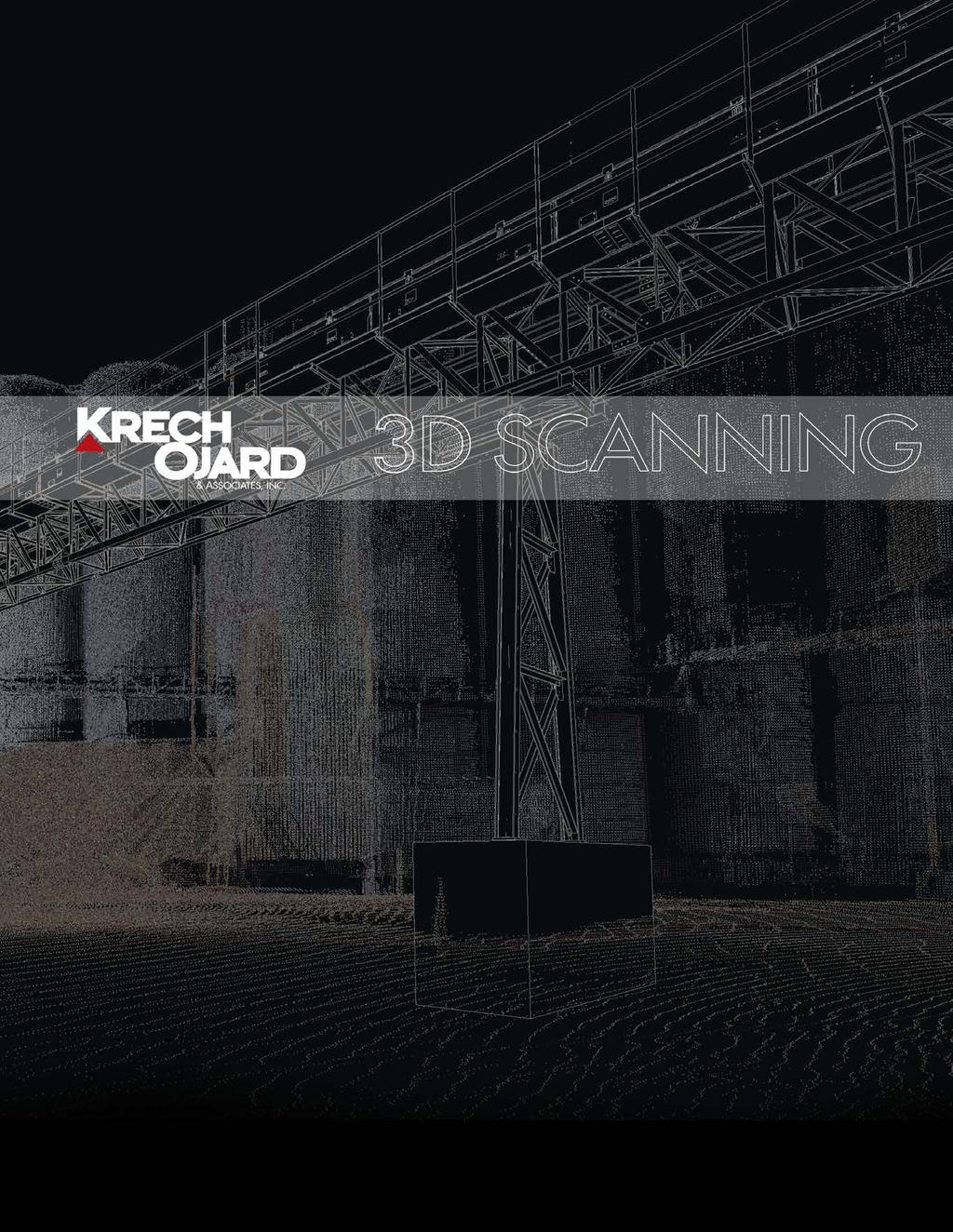
2 Services provided include: 3D Scanning of Existing Structures & Equipment 3D Modeling for Current or Future Planning What can be scanned? Any 3-Dimensional Space Industrial Facilities Transshipment and Marine Facilities Manufacturing Facilities Interiors/Exteriors Residential/Commercial Buildings Equipment Site Environments 3D SCANNING SERVICES FOR PUBLIC & PRIVATE CLIENTS Krech Ojard performs 3D scanning services for a range of added values and on almost any structure or space. Once scanned, planning and design for a client s facility, building or plant becomes more accurate and more cost effective. Offsite engineers, architects, project managers and other professionals are able to reference up to date data and measurements. This invaluable resource offers benefits that can include, but are not limited to, more accurate records of existing structures; time and cost savings during numerous stages of project design and development, and also in future phases; better visualization and communication between clients, stakeholders, designers, and construction; aid in determining crucial spatial tolerances and measurements for engineers and architects in the office and at the ready when it is needed. New additions designed in 3d models can be placed within a digitally scanned facility long before construction phases allowing options and accurate decisions to be made at a cost effective stage in the process.


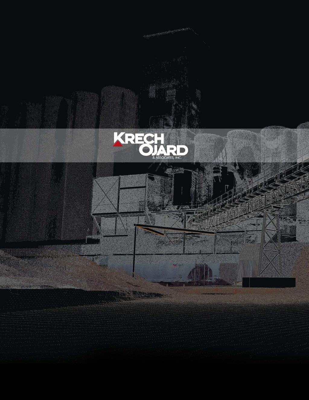
3 3D SCANNING SERVICES The large image on this page may look a little strange. It is the combination of a point cloud model from a 3D laser scan and new 3D design models representing the new structural and mechanical components to be installed at a facilit y. The point cloud model is the result of a three-dimensional laser scan, or 3D scan, which accurately detects the location of solid surfaces within the desired scan area. The size of scan areas can range from a few feet to more than one hundred feet in size. In addition, multiple scans or point clouds can be assembled into a single model which can cover an entire facilit y if necessar y. We have completed scanning projects ranging from a small room to an entire plant for clients requiring a high level of accuracy to improve project results. The illustration shown here is comprised of millions of dots or points representing real structures within our client s facilit y, which is difficult to accurately portray with this t ype of document. When viewing the raw scan data using the design soft ware, the number of data points shown can be adjusted to a substantially higher level of detail. This technology presents Krech Ojard staff members with unprecedented opportunities to improve design accuracy through the abilit y to access virtually unlimited data concerning existing conditions at our client s facilities when compared to the normal workflow of design and verification at sites that are miles away from the location that the work is being performed. As one of our designers puts it It s as if we scooped up the site and brought it back to the office to work on. Scanning activities can be performed in both indoor and outdoor environments and can allow for digital walkthroughs of facilities. Scans of above and below ground level are combined to offer unique visuals and locations of buried structures. Laser scans result in a digital point cloud that is combined with panoramic imager y to create a real world digital 3D model. Each point in the model exists as a measured data point in the 3D digital space that can be incorporated into new designs that directly impact existing structures and components. Digital images are taken at the same time as the scan and are used to add color to the data points. When the detail level is increased to show a high concentration of data points, the point cloud resembles a photograph. Our staff is currently using the 3D digital design environment for a number of client applications; including fitting new structures and upgrades within current environments and facilities, verification of as-built and pre-construction conditions, and confirmation of dimensional accuracy for a variet y of preconstructed equipment and components. The use of the 3D scan data allows us to create designs at virtually any facilit y with the highest level of precision, which results in greatly reduced field verification time and field modifications during construction. Scan of equipment and model together Basic Scan of existing equipment - model designed in place. Visualize interferences with existing structures. Geometric complications of unique environments make 3D scanning a dream solution for designers and engineers working to provide the best solutions for our client s specific needs at existing sites and facilities. The soft ware used to view and manipulate...


4 ...the scan data also allows the consolidation of existing dimensional information into a digital file package that is compatible with the design software our professionals use every day. The use of digital models has also provided additional benefits by improving coordination between disciplines, especially in areas where traditional field measurements are difficult to make or are unreliable. PROCESS, ACCURACY & EFFICIENCY An individual or small team can scan facilities and sites with very little interruption to production or site staff. Scanning units are small camera and tripod setups and small physical markers are added around the site to assure calibration and location accuracy when merging multiple scans. Aerial drones, as well as typical aerial vehicles, are also utilized to create 3d scans and collect aerial data. Aerial tools are used with either photogrammetry or LiDAR technology and are able to produce point clouds and 3d surfaces which are utilized in both 2D and 3D design software. Beyond the accuracy of data collected with these tools, aerial imagery provides a big picture view of sites and perspectives that can be equally valuable in communication with clients and the public. All these beneficial data sets can be collected in one site visit and produce usable outputs for years. Krech Ojard currently employs this technology and other tools to transform your facility or space into usable digital packages ready to interact with 3d design models for today and in future phases. Scan of large industrial facilities with new models inserted. Allows for 360 scanning for large equipment and surface area Collects precise data points for a variety of environments Contact us today for more information or examples of this service.
5 krechojard.com
The Most Comprehensive Solution for Indoor Mapping Applications
 The Most Comprehensive Solution for Indoor Mapping Applications TRIMBLE INDOOR MOBILE MAPPING SOLUTION TRIMBLE INDOOR MOBILE MAPPING SOLUTION (TIMMS): HIGH EFFICIENCY, MAXIMUM FLEXIBILITY, ALL-IN-ONE PACKAGE
Virtually Real: Terrestrial Laser Scanning
 Check. They re Chartered. Geomatics Client Guides Virtually Real: Terrestrial Laser Scanning Understanding an evolving survey technology Summary This guide gives you an overview of the technique, some
BIM & Digital Transformation Scotland Live 2018 Capturing 3D Reality at the push of a button
 BIM & Digital Transformation Scotland Live 2018 Capturing 3D Reality at the push of a button Gary Kelly Country Manager Scotland Leica Geosystems @LeicaScot Capturing 3D Reality at the push of a button
Aerial and Mobile LiDAR Data Fusion
 Creating Value Delivering Solutions Aerial and Mobile LiDAR Data Fusion Dr. Srini Dharmapuri, CP, PMP What You Will Learn About LiDAR Fusion Mobile and Aerial LiDAR Technology Components & Parameters Project
PREMIUM PROPERTY MARKETING
 PREMIUM PROPERTY MARKETING 01789 722 500 contact@mcs-media.com www.mcs-media.com WHAT WE DO Aerial Drone videos Ground based videos Architectural photography 3D Walkthroughs Single property websites Professional
Trimble Indoor Mobile Mapping Solution
 Kevin Perkins Applanix Corp. NATIONAL SURVEYING, MAPPING & GEOSPATIAL CONFERENCE - MARCH 13-17, 2017 Trimble Indoor Mobile Mapping Solution Why Indoor Mapping? The need: As-built maps/models of indoor
Displayed with permission The American Surveyor April/May Copyright 2009 Cheves Media
 NASA s Environmental Simulation Chamber A at the Johnson Space Center in Houston will require upgrades to accommodate testing of components for the new space telescopes. Laser scanning with the FARO LS
Mobile Mapping and Navigation. Brad Kohlmeyer NAVTEQ Research
 Mobile Mapping and Navigation Brad Kohlmeyer NAVTEQ Research Mobile Mapping & Navigation Markets Automotive Enterprise Internet & Wireless Mobile Devices 2 Local Knowledge & Presence Used to Create Most
A New Way to Control Mobile LiDAR Data
 A New Way to Control Mobile LiDAR Data Survey control has always been a critically important issue when conducting mobile LiDAR surveys. While the accuracies currently being achieved with the most capable
City of San Antonio Utilizing Advanced Technologies for Stormwater System Mapping and Condition Assessments
 City of San Antonio Utilizing Advanced Technologies for Stormwater System Mapping and Condition Assessments Prepared for: Prepared by Noelle Gaspard, PE, GISP, CFM Agenda Purpose Project Overview Challenges
Simplicity is the new black: The BLK360 story
 Simplicity is the new black: The BLK360 story Vanda KADLECIKOVA Leica Geosystems Heerbrugg, Switzerland E-mail: vanda.kadlecikova@leica-geosystems.com Abstract Meet the game changer. The new Leica BLK360
Trimble VISION Positions from Pictures
 Trimble VISION Positions from Pictures This session will cover What Is Trimble VISION? Trimble VISION Portfolio What Do you Need? How Does It Work & How Accurate Is It? Applications Resources Trimble VISION
Revealing the. Stonehenge. In a major project for English Heritage, Through 3D Digital Modelling. By Neil McLeod
 Revealing the Secrets of Stonehenge Through 3D Digital Modelling In a major project for English Heritage, survey specialists Greenhatch Group used laser scanning, digital photogrammetry and Geomagic Studio
APPENDIX E2. Vernal Pool Watershed Mapping
 APPENDIX E2 Vernal Pool Watershed Mapping MEMORANDUM To: U.S. Fish and Wildlife Service From: Tyler Friesen, Dudek Subject: SSHCP Vernal Pool Watershed Analysis Using LIDAR Data Date: February 6, 2014
JANUARY 2017 WATER S END. Mobile Mapping. Station to Station. Decided Guidance Indoor application. Implementing BIM. A fixed boundary R E YEARS
 JANUARY 2017 WATER S END Mobile Mapping Station to Station Decided Guidance Indoor application Implementing BIM A fixed boundary R LEB ATING E C 30 YEARS Indoor Mobile Mapping A unique approach to interior
A Sweet Success in Plant Documentation for Michigan Sugar Company
 A Sweet Success in Plant Documentation for Michigan Sugar Company COMPANY LOCATION 3D Imaging Services Flint, MI TOOLS USED Leica ScanStation P40 (solutionshardware-p40.html) Leica Cyclone Software (solutionssoftware-cyclone.html)
Creating a Competitive Edge with FARO Scanners
 CASE STUDY Creating a Competitive Edge with FARO Scanners Wesley Grimes President of Collision Engineering Associates, Inc Crash Reconstruction Firm Adopts FARO Laser Scanners To Safely Capture Scenes
User Task Flows. What are Task Flows? Why use task flows? bringing the user into the development process. Challenge:
 M ore often than not, the needs and expectations of the user are present only in the abstract when design and development of an application are being discussed. Use cases tend to reflect system interaction,
Overview of the Trimble TX5 Laser Scanner
 Overview of the Trimble TX5 Laser Scanner Trimble TX5 Revolutionary and versatile scanning solution Compact / Lightweight Efficient Economical Ease of Use Small and Compact Smallest and most compact 3D
Virtual and remote inspection methods
 Virtual and remote inspection methods Rasmus Lindeneg Johansen, RLJ@cowi.dk 1 How do we inspect "today"? 2 Inspection "today" Manual inspections From the ground From lift/platform By rope Data was collected
COLLABORATION is KEY
 AN AERIAL ADVANTAGE COLLABORATION is KEY LIVING AND WORKING IN A WORLD OF FAST TECHNOLOGICAL ADVANCEMENT, COLLABORATION OF SKILLS IS BECOMING MORE COMMONPLACE. DTM Technologies Ltd and Seahawk AP have
Cross-Discipline Coordination in Autodesk s Revit Platform
 Cross-Discipline Coordination in Autodesk s Revit Platform Matt Dillon The DC CADD Company, Inc. AB214-4 The Revit platform offers many opportunities and tools for coordination that have not been possible
Trimble Geospatial Division Integrated Solutions for Geomatics professions. Volker Zirn Regional Sales Representative
 Trimble Geospatial Division Integrated Solutions for Geomatics professions Volker Zirn Regional Sales Representative 1 Agenda Trimble GeoSpatial Division Airborne System Solutions Trimble Inpho Software
USING CONTEXTCAPTURE IN 3D MODELING PRELIMINARY VISUALIZATION PRODUCTION
 USING CONTEXTCAPTURE IN 3D MODELING PRELIMINARY VISUALIZATION PRODUCTION Mo Harmon, Solutions Executive, Roads and Bridges, Bentley Kurt Stiles, VERG Manager, WSDOT Ron Jones, VERG 3D Modeler-Animator,
Location Intelligence Solution
 Location Intelligence Solution improving orientation, navigation and information management capabilities inside complex facilities Conceptual design study Dipl.-Geogr. Dirk SCHMIDT Session: Technology
IT Transformation Through ESPCs
 June 27, 2013 IT Transformation Through ESPCs Restricted Siemens AG 2013. All rights reserved. siemens.com/answers Contents Integration of IT with Facilities ESPCs as Related to Data Centers Measurement
Commercial suas The Right Tool for the Right Job
 Commercial suas The Right Tool for the Right Job Presentation Objectives Overview of current data collection technologies UAS Systems Overview Surveyor 2.0 Project Case Study Mobile LiDAR & suas How Do
Innovation. lidarnews.com. volume 3 issue 5. Points clouds and terrain models support rail project. Structured light scanning for human head modeling
 volume 3 issue 5 LIDAR lidarnews.com SCALABILITY Points clouds and terrain models support rail project EXPRESSION Structured light scanning for human head modeling FLUCTUATION Scanning moving objects using
2/9/2016. Session Agenda: Implementing new Geospatial Technologies for more efficient data capture
 Implementing new Geospatial Technologies for more efficient data capture Jay Haskamp Applied Geospatial Engineer Steve Richter VP Sales Session Agenda: Today s changing technologies and what lies ahead
HiFi Visual Target Methods for measuring optical and geometrical characteristics of soft car targets for ADAS and AD
 HiFi Visual Target Methods for measuring optical and geometrical characteristics of soft car targets for ADAS and AD S. Nord, M. Lindgren, J. Spetz, RISE Research Institutes of Sweden Project Information
AN APPLICATION-CENTRIC APPROACH TO DATA CENTER MIGRATION
 WHITE PAPER AN APPLICATION-CENTRIC APPROACH TO DATA CENTER MIGRATION Five key success factors Abstract IT organizations today are under constant business pressure to transform their infrastructure to reduce
Gregory Walsh, Ph.D. San Ramon, CA January 25, 2011
 Leica ScanStation:: Calibration and QA Gregory Walsh, Ph.D. San Ramon, CA January 25, 2011 1. Summary Leica Geosystems, in creating the Leica Scanstation family of products, has designed and conducted
ROAD-SCANNER COMPACT APPLICATION FIELDS MAIN FEATURES
 ROAD-SCANNER COMPACT Mobile Mapping System by GEXCEL & SITECO collaboration A smaller mobile system for asset management and cartography suited for ZOLLER & FRÖHLICH PROFILER 9012 laser scanner. 2 + 3
HIGH-DEFINITION SURVEY AND BIM PRESENTATION FOR BIM-MEP AUS
 www.aamgroup.com/bim HIGH-DEFINITION SURVEY AND BIM PRESENTATION FOR BIM-MEP AUS Matt Rumbelow, B.Arch AAM BIM Coordinator ABOUT AAM Reality Captured. Certainty Delivered Reality Captured. Certainty Delivered
Reality Modeling Drone Capture Guide
 Reality Modeling Drone Capture Guide Discover the best practices for photo acquisition-leveraging drones to create 3D reality models with ContextCapture, Bentley s reality modeling software. Learn the
3D Scanners help Grovely Wood speed up their production time
 Coventry St Michaels Cathedral, built in the late 14th century. It was one of the most beautiful and largest parish churches of its time, in England until it was destroyed during the Second World War.
Drones and Supercalculators : A New Field of Investigation in Photogrammetry.
 1 Drones and Supercalculators : A New Field of Investigation in Photogrammetry. The Rise in Popularity of Applications and Performances. Introduction... p. 2 Archeology... p. 3 National Heritage Sites
Quality Assurance and Quality Control Procedures for Survey-Grade Mobile Mapping Systems
 Quality Assurance and Quality Control Procedures for Survey-Grade Mobile Mapping Systems Latin America Geospatial Forum November, 2015 Agenda 1. Who is Teledyne Optech 2. The Lynx Mobile Mapper 3. Mobile
Validation of Aerial LiDAR Products For Transportation Applications
 Creating Value Delivering Solutions Validation of Aerial LiDAR Products For Transportation Applications Dr. Srini Dharmapuri, CP, PMP Michael Baker Jr., Inc. Lauren Little, PE Alaska DOT Public Facility
Advanced Data Procurement From A Contractors Perspective
 Advanced Data Procurement From a Contractors Perspective Advanced Data Procurement From A Contractors Perspective Brian K. Smith & Travis Rauscher, PE 1 Session Summary Laser scanning and UAV data procurement
MODERN DIMENSIONAL MEASURING TECHNIQUES BASED ON OPTICAL PRINCIPLES
 MODERN DIMENSIONAL MEASURING TECHNIQUES BASED ON OPTICAL PRINCIPLES J. Reichweger 1, J. Enzendorfer 1 and E. Müller 2 1 Steyr Daimler Puch Engineering Center Steyr GmbH Schönauerstrasse 5, A-4400 Steyr,
Integrated Projects. Madonna di Pietranico Pompeii insula V1 V I S UA L COMPUTING L A B I ST I - C N R
 Integrated Projects Madonna di Pietranico Pompeii insula V1 V I S UA L COMPUTING L A B I ST I - C N R La Madonna di Pietranico Pietranico s Madonna Terracotta statue, destroyed by an earthquake. We used
3D Scanners help Grovely Wood
 The BENNINGHOVEN company was founded by Otto Benninghoven in 1909, in Hilden, Germany and was set up to produce gear wheels and machine tools. The company diversified into the field of industrial combustion
Drone2Map: an Introduction. October 2017
 Drone2Map: an Introduction October 2017 Drone2Map: An Introduction Topics: - Introduction to Drone Mapping - Coordinate Systems - Overview of Drone2Map - Basic Drone2Map Workflow - 2D Data Processing -
EQUIPMENT REMOVAL AND INSTALLATION PROCESS USING LASER SCANNING TECHNOLOGY
 EQUIPMENT REMOVAL AND INSTALLATION PROCESS USING LASER SCANNING TECHNOLOGY LASER SCANNING TECHNOLOGY PROVIDES A VERY EFFECTIVE TOOL TO SUPPORT COMPLEX RIGGING PLANNING AND EXECUTION EQUIPMENT REMOVAL &
A New Protocol of CSI For The Royal Canadian Mounted Police
 A New Protocol of CSI For The Royal Canadian Mounted Police I. Introduction The Royal Canadian Mounted Police started using Unmanned Aerial Vehicles to help them with their work on collision and crime
GIS Data Collection. This chapter reviews the main methods of GIS data capture and transfer and introduces key practical management issues.
 9 GIS Data Collection OVERVIEW This chapter reviews the main methods of GIS data capture and transfer and introduces key practical management issues. It distinguishes between primary (direct measurement)
Draper Aden VIRTUAL CONSTRUCTION DOCUMENT, DESIGN, AND BUILD IN 3D
 VIRTUAL CONSTRUCTION VIRTUAL CONSTRUCTION The design and construction environment has changed. While the goals of completing a project on time, within budget, and at the expected level of quality remain
Hardware 3D Mapping Systems
 Hardware 3D Mapping Systems About Us GreenValley International GreenValley International provides 3D mapping solutions that include mobile & aerial LiDAR acquisition hardware, post-processing software
QUALITY CONTROL OF PARTS AND ASSEMBLIES USING SOFTWARE GOM INSPECT BASED ON PORTABLE CMM DATA
 8 th International Quality Conference May 23 rd 2014 Center for Quality, Faculty of Engineering, University of Kragujevac Milan Blagojevic 1) Miroslav Zivkovic 1) 1) Faculty of Engineering, University
Photogrammetry: A Modern Tool for Crash Scene Mapping
 Photogrammetry: A Modern Tool for Crash Scene Mapping Background A police accident investigator (AI) has many tasks when arriving at a crash scene. The officer s highest priority is public safety; the
Terrestrial LiDAR. Patrick Crawford. Harnessing the Power of Big Data for Asset and Facility Management WHITE PAPER SHAFER, KLINE & WARREN
 WHITE PAPER Terrestrial LiDAR Harnessing the Power of Big Data for Asset and Facility Management Patrick Crawford Team Leader, Geospatial Systems SHAFER, KLINE & WARREN Executive Summary Terrestrial LiDAR
Suite en It Up with Autodesk ReCap
 Chad Studer ADSK Solutions RC3165 Static and mobile laser scanning technologies capture millions of points and provide photorealistic interactive virtual sites known as point clouds. With Autodesk ReCap
ROAD SURFACE STRUCTURE MONITORING AND ANALYSIS USING HIGH PRECISION GPS MOBILE MEASUREMENT SYSTEMS (MMS)
") ROAD SURFACE STRUCTURE MONITORING AND ANALYSIS USING HIGH PRECISION GPS MOBILE MEASUREMENT SYSTEMS (MMS) Bonifacio R. Prieto PASCO Philippines Corporation, Pasig City, 1605, Philippines Email: bonifacio_prieto@pascoph.com
ROAD SURFACE STRUCTURE MONITORING AND ANALYSIS USING HIGH PRECISION GPS MOBILE MEASUREMENT SYSTEMS (MMS) Bonifacio R. Prieto PASCO Philippines Corporation, Pasig City, 1605, Philippines Email: bonifacio_prieto@pascoph.com
UAV s in Surveying: Integration/processes/deliverables A-Z. 3Dsurvey.si
 UAV s in Surveying: Integration/processes/deliverables A-Z Info@eGPS.net TODAY S PROGRAM Introduction to photogrammetry and 3Dsurvey Theoretical facts about the technology and basics of 3dsurvey Introduction
Annual Report for the Utility Savings Initiative
 Report to the North Carolina General Assembly Annual Report for the Utility Savings Initiative July 1, 2016 June 30, 2017 NORTH CAROLINA DEPARTMENT OF ENVIRONMENTAL QUALITY http://portal.ncdenr.org Page
DRONE MAPPING FOR CONSTRUCTION
 DRONE MAPPING FOR CONSTRUCTION POWERFUL SOLUTIONS FOR AS-BUILT SURVEYS AND SITE DOCUMENTATION - AUTOMATED FLEXIBLE PROCESSING - REPEATABLE RELIABLE ACCURACY - APPLICABLE RESULTS WE CAPTURE IMAGES FROM
Characterizing Strategies of Fixing Full Scale Models in Construction Photogrammetric Surveying. Ryan Hough and Fei Dai
 697 Characterizing Strategies of Fixing Full Scale Models in Construction Photogrammetric Surveying Ryan Hough and Fei Dai West Virginia University, Department of Civil and Environmental Engineering, P.O.
TopoDOT introduced the use of E57 format data in its version 6.0. This document shows step by step how to:
 TopoDOT Technotes Original: October 23, 2014 Update: August 25, 2016 To: General Release From: Jennifer Triana Certainty 3D, LLC Re: How to Use E57 Format in TopoDOT Background The E57 file format is a
OPEN. INTELLIGENT. Laser Scanning Software Solutions
 OPEN. INTELLIGENT. Laser Scanning Software Solutions www.lfm-software.com The Future of Laser Scanning Safe and efficient operation of complex engineering assets, and the efficient management of their
Surveying like never before
 CAD functionalities GCP Mapping and Aerial Image Processing Software for Land Surveying Specialists Surveying like never before www.3dsurvey.si Modri Planet d.o.o., Distributors: info@3dsurvey.si +386
 www.lfm-software.com LFM Software Overview Realise the true value of your laser scan data. Outside the EPC environment, Owner Operators are now also recognising the benefits of 3D laser scanning. Laser
The All-in-One Solution for General Design, BIM and Mechanical
 The All-in-One Solution for General Design, BIM and Mechanical Bricsys represents the future of the.dwg format, with comprehensive workflows for general design, mechanical design and BIM. Here s the best
Joint Application Design & Function Point Analysis the Perfect Match By Sherry Ferrell & Roger Heller
 Joint Application Design & Function Point Analysis the Perfect Match By Sherry Ferrell & Roger Heller Introduction The old adage It s not what you know but when you know it that counts is certainly true
Microwave. Infrared. Preprogrammed Chip
 Advanced Technology for Design Mapping and Construction Layout AACE A.A.C.E. Meeting August 5, 2009 Daniel K. Mardock RBF Consulting Survey Manager Registered Land Surveyor Certified Federal Surveyor Arizona
3D Modelling Creating Tool for Landscape Design: Camera
 78 Full Paper 3D Modelling Creating Tool for Landscape Design: Camera Ahmet Benliay 1, Isa Eren Akbiyik 2 1 Akdeniz University Faculty of Architecture, Landscape Architecture Department, Antalya/Turkey
v Working with Rasters SMS 12.1 Tutorial Requirements Raster Module Map Module Mesh Module Time minutes Prerequisites Overview Tutorial
 v. 12.1 SMS 12.1 Tutorial Objectives This tutorial teaches how to import a Raster, view elevations at individual points, change display options for multiple views of the data, show the 2D profile plots,
BIM PROCESS COMPARING NEW BUILD WITH EXISTING ASSETS A VERY QUICK SUMMARY OF THE PROCESS
 : STEPPING INTO THE FUTURE WITH THE PAST HYBRID MODELLING IN THE BIM PROCESS CARL BROOKES 8 DECEMBER 2017 INTRODUCTION Very quick summary of BIM process Comparing New build with existing assets 3D model
Leica DISTO X4 Designed for bright, outdoor environments
 Leica DISTO X4 Designed for bright, outdoor environments Pointfinder camera The DISTO X4 is equipped with a Pointfinder camera allowing you to easily target distant objects in bright sunlight. Even if
Four Mainstream Reality Capture Tools* Optical GNSS (or more commonly GPS) Lidar. Photogrammetry 12/20/2015. Static Mobile Aerial
 Lidar. Photogrammetry 12/20/2015. Static Mobile Aerial") Four Mainstream Reality Capture Tools* Optical GNSS (or more commonly GPS) Lidar Static Mobile Aerial Photogrammetry UAV Collected Ground Collected 1 Optical Consists of three measurement devices H Angle,
Four Mainstream Reality Capture Tools* Optical GNSS (or more commonly GPS) Lidar Static Mobile Aerial Photogrammetry UAV Collected Ground Collected 1 Optical Consists of three measurement devices H Angle,
V-Sentinel: A Novel Framework for Situational Awareness and Surveillance
 V-Sentinel: A Novel Framework for Situational Awareness and Surveillance Suya You Integrated Media Systems Center Computer Science Department University of Southern California March 2005 1 Objective Developing
Trimble MX2 mobile mapping
 Trimble MX2 mobile mapping user applications Point clouds within your reach The Trimble MX2 is a vehicle-mounted spatial imaging system which combines high resolution laser scanning and panoramic cameras
Assessing the Accuracy of Stockpile Volumes Obtained Through Aerial Surveying
 CASE STUDY Assessing the Accuracy of Stockpile Volumes Obtained Through Aerial Surveying Martin Remote Sensing share surveying insight DroneDeploy Introduction This report comes to us from Kelsey Martin,
Texturing Techniques in 3D City Modeling
 Texturing Techniques in 3D City Modeling 1 İdris Kahraman, 2 İsmail Rakıp Karaş, Faculty of Engineering, Department of Computer Engineering, Karabuk University, Turkey 1 idriskahraman@karabuk.edu.tr, 2
Set up and Foundation of the Husky
 Set up and Foundation of the Husky Marisa Warner, Jeremy Gottlieb, Gabriel Elkaim Worcester Polytechnic Institute University of California, Santa Cruz Abstract Clearpath s Husky A200 is an unmanned ground
Reality Capture: From Point Cloud To Design To Visualisation. by Shuaib Yunos, Baker Baynes
 Reality Capture: From Point Cloud To Design To Visualisation by Shuaib Yunos, Baker Baynes Perspective: Design & Construction Designers are conceiving buildings differently. Building owners expect a lot
City of San Antonio Utilizing Advanced Technologies for Stormwater System Mapping and Condition Assessments
 City of San Antonio Utilizing Advanced Technologies for Stormwater System Mapping and Condition Assessments Prepared for: 2017 ESRI Users Conference Prepared by Noelle Gaspard, PE, GISP, CFM July 12,2017
RealWorld. HUAZHENG Panoramic Photorealistic 3D. Geospatial Data at Engineering Level
 3D RealWorld HUAZHENG Panoramic Photorealistic 3D Geospatial Data at Engineering Level District Drainage Facilities Management Simulate the extreme weather effect on buildings, road networks, and especially
EinScan-Pro vs. EinScan-Pro+
 China s first OTC company in the 3D digitizing and printing industry(830978) EinScan-Pro vs. EinScan-Pro+ Copyright 2015-2016 Shining 3D. All rights reserved. Version: November 2017 EinScan-Pro & Pro+
(THE) ULTIMATE CONTACT STRATEGY HOW TO USE PHONE AND FOR CONTACT AND CONVERSION SUCCESS SALES OPTIMIZATION STUDY
 ULTIMATE CONTACT STRATEGY HOW TO USE PHONE AND FOR CONTACT AND CONVERSION SUCCESS SALES OPTIMIZATION STUDY") (THE) ULTIMATE CONTACT STRATEGY HOW TO USE PHONE AND EMAIL FOR CONTACT AND CONVERSION SUCCESS EXECUTIVE SUMMARY This study, derived from the data of nearly 3.5 million leads, breaks new ground, revealing
(THE) ULTIMATE CONTACT STRATEGY HOW TO USE PHONE AND EMAIL FOR CONTACT AND CONVERSION SUCCESS EXECUTIVE SUMMARY This study, derived from the data of nearly 3.5 million leads, breaks new ground, revealing
3-D MEASURING FOR AN ENGINEER-TO-ORDER SECONDARY WOOD PROCESSING INDUSTRY
 3-D MEASURING FOR AN ENGINEER-TO-ORDER SECONDARY WOOD PROCESSING INDUSTRY Samuel Forsman 1, Lars Laitila 2, Niclas Björngrim 3 ABSTRACT: The construction industry has been criticized for not keeping up
Capturing Reality with Point Clouds: Applications, Challenges and Solutions
 Capturing Reality with Point Clouds: Applications, Challenges and Solutions Rico Richter 1 st February 2017 Oracle Spatial Summit at BIWA 2017 Hasso Plattner Institute Point Cloud Analytics and Visualization
Digital Softcopy Photogrammetry
 LLP Erasmus IP EPOCHE 2013 Thassos Island, Greece, 2-16 June 2013 Digital Softcopy Photogrammetry Prof. Levente DIMEN The 1 Decembrie 1918 University of Alba Iulia, Romania GENERAL CONTEXT In the last
Acuity. Acuity Sensors and Scanners. Product Brochure
 Acuity Acuity Sensors and Scanners Product Brochure CCS PRIMA The CCS Prima series of confocal displacement sensors are amongst the most precise measuring instruments in the world. Using a confocal chromatic
Emprise Bank chooses Arecont Vision to provide megapixel camera surveillance solution
 Emprise Bank chooses Arecont Vision to provide megapixel camera surveillance solution Published on 28 Feb 2009 Arecont Vision provides Emprise Bank with megapixel camera surveillance solution Emprise Bank
Merging Geospatial Technologies to Improve the Bottom Line. John Whitehead Trimble Navigation Limited
 Merging Geospatial Technologies to Improve the Bottom Line John Whitehead Trimble Navigation Limited Trimble: Data Collection to Decision Making Today s Survey Professional Today s Customer Requirements
Overview. 1. Aerial LiDAR in Wisconsin (20 minutes) 2. Demonstration of data in CAD (30 minutes) 3. High Density LiDAR (20 minutes)
 2. Demonstration of data in CAD (30 minutes) 3. High Density LiDAR (20 minutes)") Overview 1. Aerial LiDAR in Wisconsin (20 minutes) 2. Demonstration of data in CAD (30 minutes) 3. High Density LiDAR (20 minutes) 4. Aerial lidar technology advancements (15 minutes) 5. Q & A 1. Aerial
Overview 1. Aerial LiDAR in Wisconsin (20 minutes) 2. Demonstration of data in CAD (30 minutes) 3. High Density LiDAR (20 minutes) 4. Aerial lidar technology advancements (15 minutes) 5. Q & A 1. Aerial
Visualisation of Photovoltaic Clad Buildings
 Visualisation of Photovoltaic Clad Buildings Margaret Horne, Robert Hill, Chris Underwood University of Northumbria, Newcastle upon Tyne, NE1 8ST, UK Tel: +44 191 227 4720 Fax: +44 191 227 3167 e-mail:
Trimble Business Center Software, v3.30
 Trimble Business Center Software, v3.30 We are pleased to announce a new version of the Trimble Business Center software, version 3.30. This new version includes over 30 new features and enhancements increasing
Integrating the Generations, FIG Working Week 2008,Stockholm, Sweden June 2008
 H. Murat Yilmaz, Aksaray University,Turkey Omer Mutluoglu, Selçuk University, Turkey Murat Yakar, Selçuk University,Turkey Cutting and filling volume calculation are important issues in many engineering
Technology Solutions Group Specialized Real Estate Services
 COLLIERS INTERNATIONAL Technology Solutions Group Specialized Real Estate Services Accelerating success. Colliers International Technology Solutions P. 1 This document has been prepared by Colliers International
technical notes trimble business center software
 technical notes trimble business center software A POWERFUL SURVEY DATA OFFICE SOFTWARE SUITE DESIGNED FOR TODAY'S FAST-PACED SURVEYING OFFICE, TRIMBLE BUSINESS CENTER SOFTWARE UNLOCKS THE POTENTIAL OF
TIMMS : FAST, ACCURATE & COST-EFFECTIVE INDOOR MAPPING
 TIMMS : FAST, ACCURATE & COST-EFFECTIVE INDOOR MAPPING Designed for ease-of-use and maneuverability, TIMMS is a high-productivity tool for accurately measuring, georeferencing and modeling interior spaces
LS516/LSG516 Self-leveling Rotating Laser Instruction Manual ( )
") LS516/LSG516 Self-leveling Rotating Laser Instruction Manual (2009-8-14) Contents 1. Features and Functions 2. User Safety 3. Nomenclature 4. Operation Instruction 5. Self-check and calibration 6. Application
LS516/LSG516 Self-leveling Rotating Laser Instruction Manual (2009-8-14) Contents 1. Features and Functions 2. User Safety 3. Nomenclature 4. Operation Instruction 5. Self-check and calibration 6. Application
COMPUTER GRAPHICS ANIMATION FOR CONSTRUCTION MANAGEMENT
 COMPUTER GRAPHICS ANIMATION FOR CONSTRUCTION MANAGEMENT Yoshihiko FUKUCHI *, Ichiro KOBAYASHI ** ABSTRACT : Computer graphics animation systems provide the ability to integrate on-site engineers* expertise
FIVE BEST PRACTICES FOR ENSURING A SUCCESSFUL SQL SERVER MIGRATION
 FIVE BEST PRACTICES FOR ENSURING A SUCCESSFUL SQL SERVER MIGRATION The process of planning and executing SQL Server migrations can be complex and risk-prone. This is a case where the right approach and
Simply powerful. Pix4Dmapper features the raycloud. Read more on Next generation aerial image processing software
 Next generation aerial image processing software Simply powerful Pix4D is your solution to convert thousands of aerial images taken by lightweight UAV or aircraft into georeferenced 2D mosaics and 3D surface
Interdisciplinary studio for teaching 3D landscape visualization: Lessons from the LVML
 Interdisciplinary studio for teaching 3D landscape visualization: Lessons from the LVML ETH Zurich Dr. Ulrike Wissen Hayek, PLUS James Melsom, ILA Noemi Neuenschwander, PLUS Prof. Dr. Christophe Girot,
#65 MONITORING AND PREDICTING PEDESTRIAN BEHAVIOR AT TRAFFIC INTERSECTIONS
 #65 MONITORING AND PREDICTING PEDESTRIAN BEHAVIOR AT TRAFFIC INTERSECTIONS Final Research Report Luis E. Navarro-Serment, Ph.D. The Robotics Institute Carnegie Mellon University Disclaimer The contents
IP-S2 HD. High Definition 3D Mobile Mapping System
 IP-S2 HD High Definition 3D Mobile Mapping System Integrated, turnkey solution Georeferenced, Time-Stamped, Point Clouds and Imagery High Density, Long Range LiDAR sensor for ultimate in visual detail