Payloads. Which one(s) are right for your organization?
|
|
|
- Harry Clifford Clark
- 6 years ago
- Views:
Transcription
1 Payloads Which one(s) are right for your organization?


2 What is a payload anyway? Not as simple as it may sound and critically important. Integrated and fixed? Interchangeable? Field changeable? Impact on battery life? Designed to deliver or construct something?
3 Payload Technically: Refers to the amount of load, typically excluding the weight of the operational UAV, that can be carried. Included in the regulated weight of the UAS. suas is less than 55 lbs. including the weight of the aircraft, battery and payload (at any time). Practically speaking: For a UAV, the payload typically refers to the thing that you will be carrying. Be that a camera, a set of cameras, a rope, some water, etc. For UAV s which carry only built in integrated cameras, there is often no payload specification. Payloads can cost more than the UAV. Caution there is some lack of consistency in UAS specifications regarding what is included when a payload is specified. Sometimes, batteries are included, sometimes not. Sometimes low range batteries.

4 Imaging and non-imaging Payloads Imaging Payloads Digital Cameras Video Cameras Infrared Cameras Hyperspectral Sensors LIDAR (Light Distance and Ranging) Combinations Non-Imaging Payloads People yes people Ropes Supplies Radios RADAR Dropping devices Chemicals Tethers Munitions Important Note: While I show pictures of real products here, I m making no statements about quality or use of a particular product.
 Yuneec CG04: 3x Optical Zoom 16 MP 4/3 CMOS Sensor 4K Video This is a consumer/prosumer digital camera by")
5 Imaging Payloads Most common and simplest UAS payload is just a camera Imaging is driving the commercial UAS Market GoPro or commercial camera Integrated comes with the UAV Still/Video usually both Stabilization methods digital, optical, gimbal Navigation Cameras (obstacle avoidance) Yuneec CG04: 3x Optical Zoom 16 MP 4/3 CMOS Sensor 4K Video This is a consumer/prosumer digital camera by Panasonic, packed for a UAS.
. Example A very nice 8x10 photograph can come from 3.2MP. 4K TV s are 8.3 MP.")
6 Digital Camera Specifications Mega Pixels (MP): The number of picture elements the camera can capture in still images. The least important specification Higher MP does not give you resolution, it gives you digital zoom (cropping). Example A very nice 8x10 photograph can come from 3.2MP. 4K TV s are 8.3 MP. Zoom: Optical Zoom: Traditional zoom lens, the entire sensor is used for the image. Digital Zoom: Cropping. You take the center out of the image, and make it bigger
.")
7 Optical Zoom Digital Zoom Wright R-3350 Duplex-Cyclone Turbo Compound Radial Engine from a P2V Aerial FF tanker (Neptune).
8 Stabilization 3 forms Optical Stabilization: Typically what is seen in consumer digital cameras. The sensor and/or an optical component is moved to compensate for camera shake. Gimbal Stabilization The sensor is mounted in a Gimbal that is stabilized. Both systems deliver full camera view and image size because the sensor or it s mount is moved. Digital Stabilization: Really only effective in video. Can take out motion from frame to frame, but not motion IN a frame. You loose some edge pixels. Can be applied afterward. Digital stabilization, like digital zoom, crops the image. In digital stabilization the crop moves around the image to capture a stable portion. Often, with digital stabilization, 4K video cannot be stabilized.

9 9
10 Colorimetry and Metamerism The color of an object in an image depends on: The spectral reflectance of the object. The spectral sensitivity of the sensor. The light shining on the sensor. Image processing in the camera. Unusual light sources like fluorescent, mercury vapor, even LED can cause very different colors to be captured and cannot be corrected for. Metamerism: Those socks matched when I put them on in the bedroom but not outside in the sun. In colorimetry, metamerism is a perceived matching of the colors that, based on differences in spectral power distribution, do not actually match. Colors that match this way are called metamers. 10
11 Hyperspectral and Infrared Both hyperspectral and infrared refer to sensors that see outside the range of the human vision system. Hyperspectral can also refer to capturing more colors but always includes non-visible light. Infrared Cameras can be: Radiometric: Essentially Calibrated. They tell you the absolute temperature of things in the scene. Non-radiometric: Non-calibrated. They tell you the relative temperature of things in the scene. Hyperspectral cameras see lots of wavelengths and can provide very interesting results by seeing the world in a way we don t. 11
: Thermal Imaging.")
12 Infrared Cameras Near Infrared (NIR µm): Used in visual augmentation systems (night vision). Not that sensitive to heat. Long wave infrared (LWIR 8-15µm): Thermal Imaging. The color in a thermal image is not real, it is put there by the camera to make it easy to interpret what you see. 12


13 Hyperspectral Cameras Most common use today is in crop, forest health or chemistry. Healthy versus unhealthy plants radiate in different colors and the amount of moisture impacts how they reflect different frequency bands. Chemicals, particularly spills, can be very obvious in Hyperspectral images. 13

14 Oil/Chemical Detection Example HYPERSPECTRAL IMAGE ANALYSIS FOR OIL SPILL DETECTION Foudan Salem,1 Menas Kafatos,1 Tarek El-Ghazawi,2 Richard Gomez,1 and Ruixin Yang1 1Center for Earth Observing and Space Research George Mason University, Fairfax, VA USA. 14

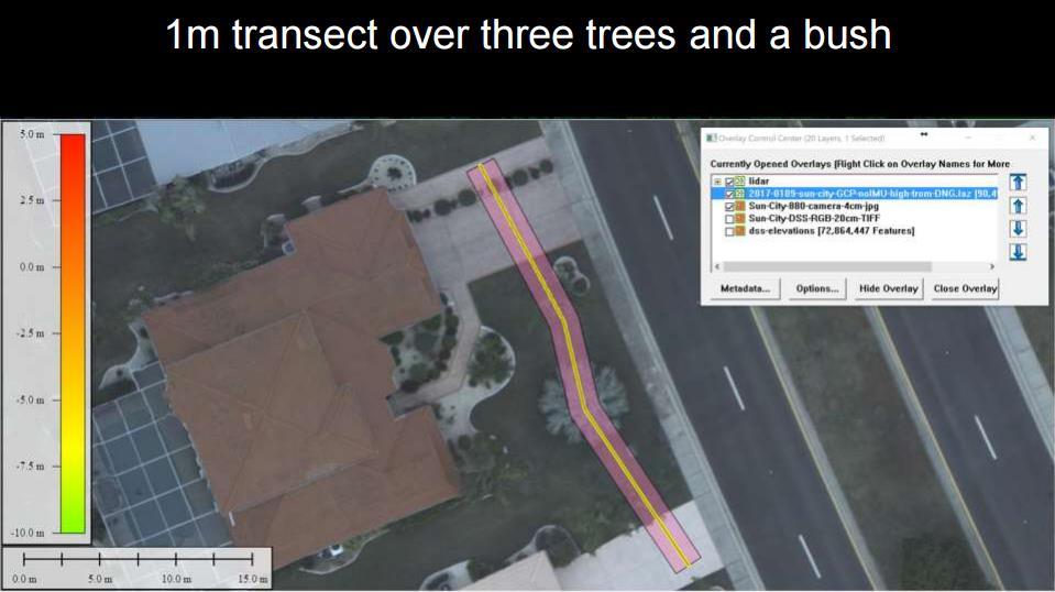
15 LIDAR (and Photogrametry) LIght Distance And Ranging: Send out a sweeping laser beam Measure the reflected light using time-of-flight to measure distance Move the beam a little bit. Rinse Repeat LIDAR Expensive but decreasing Precise Growing dramatically (autonomous vehicles, collision avoidance, etc.) Self Driving Cars Precise documentation of physical structures: Buildings, accident scenes, structure, trees, etc. Trivia question: How long does it take for light to travel 1 inch? 15


16 g/5-lidar-technologyapplications/ 85ps (pico seconds) 16

17 17

18 Photogrammetry (Structure from Motion or SFM) Taking multiple photographs creating a 3-d model Uses off the shelf sensors, so lower cost than LIDAR. Not as precise. Does not penetrate canopy/objects. More realistic. Combination of LIDAR and Photogrammetry is very powerful. 18

19 19

20 20

21 21

22 22
23 Non-imaging Payloads Carrying things to people. Ropes and rigging. Medicine, food, water. Radios, phones, batteries. Carrying chemicals. Fire Suppressant or Retardant? (not really suas) Fertilizer, pesticide, etc. Radios. Providing communications or relay. Auto-locating coverage site and creating a repeater. A word about LTE and Firstnet There is some uncertainty if a device like this can be used as an LTE tower. Having an aerial device connect to the cell network is much different than having it act as a tower. Unclear the later will happen anytime soon. 23
24 Tethers The idea of a tethered UAV is compelling from a couple of standpoints: Power can be supplied through the tether. More bandwidth between the UAV and the ground (fiber optic connection). Less operator interaction. On the other hand: Impact of weather and wind on a tethered UAV is interesting. The weight of the tether is part of the payload. The tether is an additional aerial hazard. 24
Equipment. Remote Systems & Sensors. Altitude Imaging uses professional drones and sensors operated by highly skilled remote pilots
 Remote Systems & Sensors Altitude Imaging uses professional drones and sensors operated by highly skilled remote pilots Equipment www.altitude-imaging.com About Us Altitude Imaging has been providing a
STARTING WITH DRONES. Data Collection and Remote Sensing with UAVs, etc. Dr. Bill Hazelton LS
 STARTING WITH DRONES Data Collection and Remote Sensing with UAVs, etc. Dr. Bill Hazelton LS What this Talk is About UAV-based data acquisition: What you need to get involved Processes in getting spatial
The Evolution of Thermal Imaging Cameras
 170 Years of Continued Innovation The Evolution of Thermal Imaging Cameras The World s Finest Manufacturers of Temperature, Pressure & Humidity, Test and Calibration Instruments t May, 2007 What is a Thermal
Case Study for Long- Range Beyond Visual Line of Sight Project. March 15, 2018 RMEL Transmission and Planning Conference
 Case Study for Long- Range Beyond Visual Line of Sight Project March 15, 2018 RMEL Transmission and Planning Conference 2014 HDR Architecture, 2016 2014 HDR, Inc., all all rights reserved. Helicopters
The Use and Applications of Unmanned- Aerial Systems (UAS) In Agriculture
 In Agriculture") The Use and Applications of Unmanned- Aerial Systems (UAS) In Agriculture R O B E R T A U S T I N, D E P A R T M E N T O F S O I L S C I E N C E N C S T A T E U N I V E R S I T Y DJI Inspire Photo Credit:
The Use and Applications of Unmanned- Aerial Systems (UAS) In Agriculture R O B E R T A U S T I N, D E P A R T M E N T O F S O I L S C I E N C E N C S T A T E U N I V E R S I T Y DJI Inspire Photo Credit:
CLASSIFICATION OF NONPHOTOGRAPHIC REMOTE SENSORS
 CLASSIFICATION OF NONPHOTOGRAPHIC REMOTE SENSORS PASSIVE ACTIVE DIGITAL CAMERA THERMAL (e.g. TIMS) VIDEO CAMERA MULTI- SPECTRAL SCANNERS VISIBLE & NIR MICROWAVE HYPERSPECTRAL (e.g. AVIRIS) SLAR Real Aperture
THE VANGUARD LONG RANGE SURVEILLANCE DRONE BEST USED FOR SURVEILLANCE & SECURITY INSPECTION & DETECTION WILDLIFE & GAME
 THE VANGUARD LONG RANGE SURVEILLANCE DRONE The Vanguard, our most popular UAV, is a long range surveillance drone with a configurable Data Link video Range and flight times. The Vanguard drone system is
The Use of UAV s for Gathering Spatial Information. James Van Rens CEO MAPPS Winter Conference January, 2015
 The Use of UAV s for Gathering Spatial Information James Van Rens CEO MAPPS Winter Conference January, 2015 1 UAV Technological Timeline 1980 s RPV (Remotely Piloted Vehicle) Operator on ground, almost
LEAK DETECTION UTILIZING SMALL UNMANNED AERIAL SYSTEMS (SUAS) PRESENTED BY MATT HALKER
 PRESENTED BY MATT HALKER") LEAK DETECTION UTILIZING SMALL UNMANNED AERIAL SYSTEMS (SUAS) PRESENTED BY MATT HALKER of Agenda Introduction Who we are Why we need leak detection Traditional methods of inspection Benefits of suas inspection
LEAK DETECTION UTILIZING SMALL UNMANNED AERIAL SYSTEMS (SUAS) PRESENTED BY MATT HALKER of Agenda Introduction Who we are Why we need leak detection Traditional methods of inspection Benefits of suas inspection
ULISSE COMPACT THERMAL
 2015/03/17 OUTDOOR PTZ CAMERA DUAL VISION, DAY/NIGHT AND THERMAL, FOR TOTAL DARKNESS MONITORING IP66 PROTECTION TYPE 4X TYPE 4X THERMAL WIPER INTEGRATED CAM FEATURES Variable speed: 0.1-200 /s Pan/Tilt
AISASYSTEMS PRODUCE MORE WITH LESS
 AISASYSTEMS PRODUCE MORE WITH LESS AISASYSTEMS SPECIM s AISA systems are state-of-the-art airborne hyperspectral imaging solutions covering the VNIR, NIR, SWIR and LWIR spectral ranges. The sensors unbeatable
FAA NEEDS PAYLOADS ROV SUAS. /robotics DARLEY OFFERS ROBOTICS EQUIPMENT, TRAINING & SUPPORT
 ROBOTICS FAA NEEDS PAYLOADS ROV SUAS SUPPORT TRAINING UAV Shop /robotics DARLEY OFFERS ROBOTICS EQUIPMENT, TRAINING & SUPPORT Darley is here to help with your departments drone program from the ground
Leica Systems Overview
 RC30 AERIAL CAMERA SYSTEM Leica Systems Overview The Leica RC30 aerial film camera is the culmination of decades of development, started with Wild's first aerial camera in the 1920s. Beautifully engineered
Dräger UCF 9000 NFPA Certified Thermal Imaging Camera
 Dräger UCF 9000 NFPA Certified Thermal Imaging Camera When you enter an unknown environment, you need all the information you can get as quickly and easily as possible. The Dräger UCF 9000 is an intrinsically
Project: UAV Payload Retract Mechanism. Company Background. Introduction
 Ascent Vision Technologies LLC 90 Aviation Lane Belgrade, MT 59714 Tel 406.388.2092 Fax 406.388.8133 www.ascentvision.com Project: UAV Payload Retract Mechanism Company Background Ascent Vision Technologies
TRUSTED WORLDWIDE SINCE 1908 DRONES EQUIPMENT PAYLOADS FAA NEEDS TRAINING SUPPORT
 TRUSTED WORLDWIDE SINCE 1908 DRONES EQUIPMENT PAYLOADS FAA NEEDS TRAINING SUPPORT DARLEY SINCE 1908, W.S DARLEY & COMPANY HAS BEEN DEVOTED TO SERVING THE WORLD S FIRST RESPONDERS AND WARFIGHTERS. WE ARE
UAV-based Remote Sensing Payload Comprehensive Validation System
 36th CEOS Working Group on Calibration and Validation Plenary May 13-17, 2013 at Shanghai, China UAV-based Remote Sensing Payload Comprehensive Validation System Chuan-rong LI Project PI www.aoe.cas.cn
Spectral imagers for nanosatellites
 VTT TECHNICAL RESEARCH CENTRE OF FINLAND LTD Spectral imagers for nanosatellites Finnish Satellite Workshop 2018 Antti Näsilä VTT Microspectrometers Fabry-Perot (FPI) technology for miniaturizing optical
FAA NEEDS PAYLOADS ROV SUAS. /robotics DARLEY OFFERS ROBOTICS EQUIPMENT, TRAINING & SUPPORT
 ROBOTICS FAA NEEDS PAYLOADS ROV SUAS SUPPORT TRAINING UAV Shop /robotics DARLEY OFFERS ROBOTICS EQUIPMENT, TRAINING & SUPPORT Darley is here to help with your departments drone program from the ground
below. AOTF Module / Optics R O B U ST. R E L I A B L E. A C C U R A T E AOTF Video Adapter (Series VA310) KEY FEATURES POTENTIAL APPLICATIONS
 KEY FEATURES POTENTIAL APPLICATIONS") KEY FEATURES VIS-NIR-SWIR Range 400-1700 nm Low-Power Consumption High-Switching Speed: 16,000 λ/sec Real Time Image Display Solid State / No Moving Parts High-Spectral Resolution Immune to vibration No
KEY FEATURES VIS-NIR-SWIR Range 400-1700 nm Low-Power Consumption High-Switching Speed: 16,000 λ/sec Real Time Image Display Solid State / No Moving Parts High-Spectral Resolution Immune to vibration No
Phys 1020, Day 18: Questions? Cameras, Blmfld Reminders: Next Up: digital cameras finish Optics Note Final Project proposals next week!
 Lights. Action. Phys 1020, Day 18: Questions? Cameras, Blmfld 15.1 Reminders: Next Up: digital cameras finish Optics Note Final Project proposals next week! 1 What have we learned in this section: 1) Lasers
Visionary EXT. Intelligent Camera System PATENT PENDING
 Visionary EXT Intelligent Camera System PATENT PENDING EXTended Range Aventura's Visionary EXT represents a new paradigm in video surveillance, where an operator can concentrate on watching a single screen
MAPPS 2013 Winter Conference 2013 Cornerstone Mapping, Inc. 1
 MAPPS 2013 Winter Conference 2013 Cornerstone Mapping, Inc. 1 What is Thermal Imaging? Infrared radiation is perceived as heat Heat is a qualitative measure of temperature Heat is the transfer of energy
ENY-C2005 Geoinformation in Environmental Modeling Lecture 4b: Laser scanning
 1 ENY-C2005 Geoinformation in Environmental Modeling Lecture 4b: Laser scanning Petri Rönnholm Aalto University 2 Learning objectives To recognize applications of laser scanning To understand principles
UK Industrial Vision SWIR Challenges
 UK Industrial Vision SWIR Challenges Ian Alderton ALRAD IMAGING ALRAD INSTRUMENTS LTD 1 ALRAD - Company Profile. ALRAD are a Distribution company for Imaging, Electro Optic, Analytical Components and Instruments
ProStalk PC2000. Nature Camera User Manual
 ProStalk PC2000 Nature Camera User Manual Index 1. Introduction... 3 2. Camera Specifications... 4 3. Parts Identification... 5 4. Packing Contents... 6 5. Battery and SD Card Installation... 6 6. Setup
Car DVR User Manual. 1, Key features. Preface. Notes
 Car DVR User Manual Preface Thank you for purchasing this DVR, this device has a unique ultra-portable design; it can be used in various fields, to bring you convenient, safe, colorful daily life. Please
Trimble UAS Portfolio Update. August 25 th 2015
 Trimble UAS Portfolio Update August 25 th 2015 Trimble UAS Portfolio Updates Trimble UX5 Setting the Standard in Mapping Trimble UX5 HP High Precision Surveying and Mapping Solution Trimble ZX5 Flexible
9/14/2011. Contents. Lecture 3: Spatial Data Acquisition in GIS. Dr. Bo Wu Learning Outcomes. Data Input Stream in GIS
 Contents Lecture 3: Spatial Data Acquisition in GIS Dr. Bo Wu lsbowu@polyu.edu.hk 1. Learning outcomes. Data acquisition: Manual digitization 3. Data acquisition: Field survey 4. Data acquisition: Remote
EVOLUTION OF POINT CLOUD
 Figure 1: Left and right images of a stereo pair and the disparity map (right) showing the differences of each pixel in the right and left image. (source: https://stackoverflow.com/questions/17607312/difference-between-disparity-map-and-disparity-image-in-stereo-matching)
Sensor Fusion: Potential, Challenges and Applications. Presented by KVH Industries and Geodetics, Inc. December 2016
 Sensor Fusion: Potential, Challenges and Applications Presented by KVH Industries and Geodetics, Inc. December 2016 1 KVH Industries Overview Innovative technology company 600 employees worldwide Focused
Acadia II Product Guide. Low-Power, Low-Latency Video Processing for Enhanced Vision in Any Condition
 Acadia II Product Guide Low-Power, Low-Latency Video Processing for Enhanced Vision in Any Condition The Acadia II SoC is a state-of-the-art solution for integrated vision processing. Built around advanced
THE RANGER-UAV FEATURES
 THE RANGER-UAV The Ranger Series Ranger-UAV is designed for the most demanding mapping applications, no compromises made. With a 9 meter laser range, this system produces photorealistic 3D point clouds
Overview of the Trimble TX5 Laser Scanner
 Overview of the Trimble TX5 Laser Scanner Trimble TX5 Revolutionary and versatile scanning solution Compact / Lightweight Efficient Economical Ease of Use Small and Compact Smallest and most compact 3D
Outline Sensors. EE Sensors. H.I. Bozma. Electric Electronic Engineering Bogazici University. December 13, 2017
 Electric Electronic Engineering Bogazici University December 13, 2017 Absolute position measurement Outline Motion Odometry Inertial systems Environmental Tactile Proximity Sensing Ground-Based RF Beacons
FPVMODEL. Rescue-2. Integrated with 1 OX Zoom HD Camera Intended for Search and Rescue Missions USER MANUAL
 FPVMODEL Rescue-2 USER MANUAL Integrated with 1 OX Zoom HD Camera Intended for Search and Rescue Missions FP IU n-= WWW.FPVMODEL.COM Copyright 201 7 FPVMODEL LIMITED WARNING AND DISCLAIMER Make sure not
Trail Camera TC2201NA User Manual
 Trail Camera TC2201NA User Manual Index 1. Introduction... 3 2. Digital Trail Scout Specifications... 4 3. Parts Identification... 5 4. Packing Contents... 6 5. Battery and SD Card Installation... 6 6.
HOVERFLY LIVESKY HOVERFLY DEVELOPS BEST-IN-CLASS AERIAL ROBOTS FOR INDUSTRIAL, COMMERCIAL, GOVERNMENT, AND OTHER SPECIALIZED APPLICATIONS
 HOVERFLY LIVESKY HOVERFLY DEVELOPS BEST-IN-CLASS AERIAL ROBOTS FOR INDUSTRIAL, COMMERCIAL, GOVERNMENT, AND OTHER SPECIALIZED APPLICATIONS The LiveSky is a persistent drone vehicle with powerover-tether-technology
Sensor Modalities. Sensor modality: Different modalities:
 Sensor Modalities Sensor modality: Sensors which measure same form of energy and process it in similar ways Modality refers to the raw input used by the sensors Different modalities: Sound Pressure Temperature
Goldeye G-032 TEC1. Description. Goldeye G VGA InGaAs camera with large pixel. Benefits and features. Options
 Goldeye G-032 TEC1 GigE Vision InGaAs SWIR camera VGA resolution Power over Ethernet large pixel with high dynamic Compact industrial design, no fan Description Goldeye G-032 - VGA InGaAs camera with large
Thermal and Optical Cameras. By Philip Smerkovitz TeleEye South Africa
 Thermal and Optical Cameras By Philip Smerkovitz TeleEye South Africa phil@teleeye.co.za OPTICAL CAMERAS OVERVIEW Traditional CCTV Camera s (IP and Analog, many form factors). Colour and Black and White
Forest Planning with UAVs and other Emerging Technologies. Jonathan Lok, RFT
 Forest Planning with UAVs and other Emerging Technologies Jonathan Lok, RFT Core Concepts of Planning Plan the Work Work the Plan Qualified professionals Best available data Applied knowledge and experience
Reality Modeling Drone Capture Guide
 Reality Modeling Drone Capture Guide Discover the best practices for photo acquisition-leveraging drones to create 3D reality models with ContextCapture, Bentley s reality modeling software. Learn the
Science & Technology Group
 Cannock Chase U3A Science & Technology Group Programme June 12 th PC fundamentals 1: July 17th Camera fundamentals 1 August Tablet PC fundamentals 1 September PC applications 2 (Word, Excel, Music, Photos,
INTRODUCTION SECURITY SERVICES BY WHITEBOX ROBOTICS
 A 1 INTRODUCTION SECURITY SERVICES BY WHITEBOX ROBOTICS Unmanned Ground Vehicles (UGV), Unmanned Aerial Vehicles (UAV), Remote Controlled Weapon Stations (RCWS), and Ground Rader B 1 SOLUTION SERVICES
Sensors and applications for drone based remote sensing
 Sensors and applications for drone based remote sensing Dr. Ilkka Pölönen Dr. Eija Honkavaara, NLS Dr. Heikki Saari, VTT Dr. Sakari Tuominen, Mr. Jere Kaivosoja, Luke Laboratory Joint research with Finnish
Low Cost Infra Red 'X-ray' Imaging a Useful Research Tool for Luthiers? - Part 1.
 FoMRHI Comm. 1991 John Downing Low Cost Infra Red 'X-ray' Imaging a Useful Research Tool for Luthiers? - Part 1. This Comm reports on an investigation, using a modified low cost digital camera, to determine
TopoDrone Photogrammetric Mapping Reliable, Accurate, Safe
 TopoDrone Photogrammetric Mapping Reliable, Accurate, Safe A complete solution for accurate airborne data capture and photogrammetric mapping using an unmanned aerial vehicle COST EFFICIENT SOLUTION TO
ESTGIS 2012 Priit Leomar 1
 5.12.2012 ESTGIS 2012 Priit Leomar 1 ELI 1995 Haljas tee 25 Tallinn 12012 Estonia +372 6480242 eli@eli.ee 5.12.2012 ESTGIS 2012 Priit Leomar 2 MAIN ACTIVITIES ELI ELI MILITARY SIMULATIONS ELI ENGINEERING
LiDAR Applications in Surveying and Engineering
 LiDAR Applications in Surveying and Engineering 2013 NC GIS Conference Raleigh, NC Frank A. Alex Rankin, III PE, PLS What is LiDAR? Light Detection and Ranging Analogous to RADAR, but using a different
UNIT 22. Remote Sensing and Photogrammetry. Start-up. Reading. In class discuss the following questions:
 UNIT 22 Remote Sensing and Photogrammetry Start-up In class discuss the following questions: A. What do you know about remote sensing? B. What does photogrammetry do? C. Is there a connection between the
HDC-SDOMEO51MIR-B USER MANUAL. HD Portable Rugged PTZ Cameras
 HDC-SDOMEO51MIR-B USER MANUAL HD Portable Rugged PTZ Cameras Safety Notes Thank You for Choosing Our HD table Rugged PTZ Camera! When you open the box: 1. Check that the packing and the contents are not
United Vision Offering F3.5 brightness and 60x zoom (focal length of 2000mm when used with an extender), these lenses are suited for long range surveillance, including harbor surveillance. The compact and lightweight design allows establishment of compact remote surveillance systems. Day/Night capability for high-quality imaging around the clock. Equipped with a 2x extender that can see the actions of a person at a distance of 4km. Multiple power sources supported, can use existing control systems. Iris Override function allows manual iris adjustment.
, these lenses are suited for long range surveillance, including harbor surveillance. The compact and lightweight design allows establishment of compact remote surveillance systems. Day/Night capability for high-quality imaging around the clock. Equipped with a 2x extender that can see the actions of a person at a distance of 4km. Multiple power sources supported, can use existing control systems. Iris Override function allows manual iris adjustment.") United Vision Solutions Long Range Camera System Our camera system designed for long range surveillance 24/7 utilized the most advance optical sensors and lenses [ EV3000-DIR100H Hi-Resolution 644 x 512
United Vision Solutions Long Range Camera System Our camera system designed for long range surveillance 24/7 utilized the most advance optical sensors and lenses [ EV3000-DIR100H Hi-Resolution 644 x 512
EF70-300mm f/ DO IS USM COPY ENG. Instruction
 EF70-300mm f/4.5-5.6 DO IS USM ENG Instruction Thank you for purchasing a Canon product. The Canon EF70-300mm f/4.5-5.6 DO IS USM is a high-performance, compact telephoto zoom lens for Canon EOS cameras,
1, Key features. Preface. Notes
 Car DVR User Manual Preface Thank you for purchasing this DVR, this device has a unique ultra-portable design; it can be used in various fields, to bring you convenient, safe, colorful daily life. Please
P H A S E O N E I N D U S T R I A L. T h e w o r l d l e a d e r i n h i g h r e s o l u t i o n i m a g i n g
 P H A S E O N E I N D U S T R I A L T h e w o r l d l e a d e r i n h i g h r e s o l u t i o n i m a g i n g 1 WE ARE A WORLD LEADING PROVIDER of medium format digital imaging systems and solutions for
Dräger UCF 8000 NFPA Certified Thermal Imaging Camera
 Dräger UCF 8000 NFPA Certified Thermal Imaging Camera Fires and other hazardous environments pose unseen challenges and dangers. Now you can know before you go with the Dräger UCF 8000 thermal imaging
UAV Hyperspectral system for remote sensing application
 UAV Hyperspectral system for remote sensing application The system consists airborne imaging spectrophotometer placed on a frame suitable for use aircraft, a UAV helicopter and all components needed for
Remote Sensing Introduction to the course
 Remote Sensing Introduction to the course Remote Sensing (Prof. L. Biagi) Exploitation of remotely assessed data for information retrieval Data: Digital images of the Earth, obtained by sensors recording
REMOTE SENSING LiDAR & PHOTOGRAMMETRY 19 May 2017
 REMOTE SENSING LiDAR & PHOTOGRAMMETRY 19 May 2017 SERVICES Visual Inspections Digital Terrain Models Aerial Imagery Volume Computations Thermal Inspections Photo maps Aerial Video Training & Consultancy
Missile Simulation in Support of Research, Development, Test Evaluation and Acquisition
 NDIA 2012 Missile Simulation in Support of Research, Development, Test Evaluation and Acquisition 15 May 2012 Briefed by: Stephanie Brown Reitmeier United States Army Aviation and Missile Research, Development,
Goldeye CL-032. Description. Goldeye CL all purpose SWIR camera
 Goldeye CL-032 Camera Link SWIR camera Compact industrial design, no fan Simple camera configuration via GenCP Description Goldeye CL-032 - all purpose SWIR camera The Goldeye CL-032 is a very versatile
P recise Eye. High resolution, diffraction-limited f/4.5 optical quality for high precision measurement and inspection.
 High resolution, diffraction-limited f/4.5 optical quality for high precision measurement and inspection. Long working distance makes lighting and handling easier. Compact size. Coaxial lighting available
Thermal Imaging Systems.
 www.aselsan.com.tr Thermal Imaging Systems ASELSAN offers superior capabilities to its customers with its Airborne and Naval Thermal Imaging Systems, commonly referred to as Forward Looking Infrared (FLIR).
Optical Sensors: Key Technology for the Autonomous Car
 Optical Sensors: Key Technology for the Autonomous Car Rajeev Thakur, P.E., Product Marketing Manager, Infrared Business Unit, Osram Opto Semiconductors Autonomously driven cars will combine a variety
Goldeye G-033 TEC1. Description. Goldeye G High-speed VGA InGaAs camera. Benefits and features. Options
 Goldeye G-033 TEC1 Fast GigE Vision InGaAs SWIR camera VGA resolution Power over Ethernet Compact industrial design, no fan Description Goldeye G-033 - High-speed VGA InGaAs camera The Goldeye G-033 high-speed
User Manual HT-001 1
 1 User Manual HT-001 1.Introduction...3 1.1 Application...3 1.2 Power Supply...3 1.3 Caution...3 1.4 Key Features...4 2.Whole View and Details of Camera...4 2.1 Front View of Camera...5 2.2 Back View of
SEE THE WORLD IN A NEW WAY HIKVISION THERMAL CAMERAS
 SEE THE WORLD IN A NEW WAY HIKVISION THERMAL CAMERAS All objects with a temperature above absolute zero emit thermal radiation, even at low levels. This kind of radiation, invisible to the human eye, can
Operating Instructions
 Operating Instructions INTERCHANGEABLE LENS FOR DIGITAL CAMERA Model No. H-F007014 Before use, please read these instructions completely. E -1 Contents Information for Your Safety... 2 Precautions... 4
HIGH-PERFORMANCE IMAGING SYSTEMS
 HIGH-PERFORMANCE IMAGING SYSTEMS HYPER-VISION SYSTEMS Hyperspectral, multispectral & high-speed infrared imaging HYPER-CAM HYPERSPECTRAL CAMERAS The Hyper-Cam is an advanced passive infrared hyperspectral
93-50 INFRARED SENSORS
 INFRARED SENSORS 1. DESCRIPTION That portion of the system that uses heat sensing devices such as infra-red scanners, infra-red image and detection to acquire information. This includes the Enhanced Vision
Range Sensors (time of flight) (1)
 (1)") Range Sensors (time of flight) (1) Large range distance measurement -> called range sensors Range information: key element for localization and environment modeling Ultrasonic sensors, infra-red sensors
Range Sensors (time of flight) (1) Large range distance measurement -> called range sensors Range information: key element for localization and environment modeling Ultrasonic sensors, infra-red sensors
Atom New 17 Micron Pixel Design! ATOM 1024: Uncooled oled Infrared Camera with XGA Resolution UNCOOLED CORES
 UNCOOLED CORES Atom 1024 ATOM 1024: Uncooled oled Infrared Camera with XGA Resolution New 17 Micron Pixel Design! Frame Rate: 30Hz XGA, 60Hz VGA Very Low Power Consumption < 50mK Detector Thermal Sensitivity
FC Series Traffic Camera. Architect & Engineering Specifications
 FC Series Traffic Camera Architect & Engineering Specifications This document is controlled to FLIR Technology Level 1. The information contained in this document pertains to a dual use product controlled
Sensor technology for mobile robots
 Laser application, vision application, sonar application and sensor fusion (6wasserf@informatik.uni-hamburg.de) Outline Introduction Mobile robots perception Definitions Sensor classification Sensor Performance
Thermal Imaging Thermometer Omegascope
 Thermal Imaging Thermometer Omegascope OS-XL Complete with 16MB flash card, flash card reader, hand strap, batteries, AC adaptor, carrying case, video cable and manual. Simultaneously record both image
SpatialFuser. Offers support for GNSS and INS navigation systems. Supports multiple remote sensing equipment configurations.
 SPATIALFUSER SpatialFuser SpatialFuser is designed to georeference data acquired by our LiDAR mapping systems into common mapping formats such as LAS/LAZ or GPX. The main purpose of SpatialFuser is to
Indoor Mobile Robot Navigation and Obstacle Avoidance Using a 3D Camera and Laser Scanner
 AARMS Vol. 15, No. 1 (2016) 51 59. Indoor Mobile Robot Navigation and Obstacle Avoidance Using a 3D Camera and Laser Scanner Peter KUCSERA 1 Thanks to the developing sensor technology in mobile robot navigation
Hikvision DarkFighter Technology
 WHITE PAPER Hikvision DarkFighter Technology Stunning color video in near darkness 2 Contents 1. Background... 3 2. Key Technologies... 3 2.1 DarkFighter Night Vision Sensor... 3 2.2 Darkeye Lens... 4
Chapter 3-Camera Work
 Chapter 3-Camera Work The perfect camera? Make sure the camera you purchase works for you Is it the right size? Does it have the type of lens you need? What are the features that I want? What type of storage
RANGER. Digital Trail Camera Instructions for use: Model BN057
 RANGER Digital Trail Camera Instructions for use: Model BN057 In d e x 1. Introduction... 3 2. Specifications... 3 3. Parts identification... 5 4. Package contents... 6 5. Battery and SD card installation...
MegaVideo Flex. Wide Dynamic Range Available on Some 1080p and 3MP Models. True Day/Night with Mechanical IR Cut Filter
 1.2 5 Megapixels MegaVideo IR LED Units* MegaVideo Flex camera series offers a cost-effective security solution for installations that require a flexible, compact design. Due to its small footprint, the
Goldeye G-032. Description. Goldeye G all purpose short-wave infrared camera
 Goldeye G-032 GigE Vision SWIR camera Power over Ethernet Compact industrial design, no fan Description Goldeye G-032 - all purpose short-wave infrared camera The Goldeye G-032 is a very versatile shortwave
Light Detection and Ranging (LiDAR)
") Light Detection and Ranging (LiDAR) http://code.google.com/creative/radiohead/ Types of aerial sensors passive active 1 Active sensors for mapping terrain Radar transmits microwaves in pulses determines
Light Detection and Ranging (LiDAR) http://code.google.com/creative/radiohead/ Types of aerial sensors passive active 1 Active sensors for mapping terrain Radar transmits microwaves in pulses determines
UAV s in Surveying: Integration/processes/deliverables A-Z. 3Dsurvey.si
 UAV s in Surveying: Integration/processes/deliverables A-Z Info@eGPS.net TODAY S PROGRAM Introduction to photogrammetry and 3Dsurvey Theoretical facts about the technology and basics of 3dsurvey Introduction
LIDAR: MAPPING WITH LASERS
 Grades 6 8, 9 12 30 60 minutes LIDAR: MAPPING WITH LASERS DESIGN CHALLENGE Create and map a three-dimensional landscape using a lidar laser measuring device. MATERIALS Supplies and Equipment This is a
Motion Activated Camera
 Motion Activated Camera User Manual MAC200 DN www.brinno.com 1 Register@online http://www.brinno.com/support/register.html contact us: customerservice@brinno.com more information: www.brinno.com WEL COME
Tower Camera Handbook
 ARM TR-064 Tower Camera Handbook January 2005 D. Moudry Work supported by the U.S. Department of Energy, Office of Science, Office of Biological and Environmental Research Contents 1. General Overview...1
Lecture 11. LiDAR, RADAR
 NRMT 2270, Photogrammetry/Remote Sensing Lecture 11 Calculating the Number of Photos and Flight Lines in a Photo Project LiDAR, RADAR Tomislav Sapic GIS Technologist Faculty of Natural Resources Management
Emergency Response: How dedicated short range communication will help in the future. Matthew Henchey and Tejswaroop Geetla, University at Buffalo
 Emergency Response: How dedicated short range communication will help in the future. 1.0 Introduction Matthew Henchey and Tejswaroop Geetla, University at Buffalo Dedicated short range communication (DSRC)
How to Use Passive Infrared Sensor Cameras
 ACTi Knowledge Base Category: Application Note Sub-category: Hardware, Application Model: ACM-4201, ACM-4001, TCM-4201, TCM-4001 Firmware: N/A Software: N/A Author: Ando Meritee Published: 2010/08/23 Reviewed:
Motion Activated Camera
 Motion Activated Camera User Manual MAC 200 www.brinno.com Register@online http://www.brinno.com/support/register.html contact us: customerservice@brinno.com more information: www.brinno.com WEL COME TO
Petroleum giant in the Gulf pilot module for a RF-based PERIMETER INTRUDER TRACKING SYSTEM
 Petroleum giant in the Gulf pilot module for a RF-based PERIMETER INTRUDER TRACKING SYSTEM Monitors remote installations without security manpower Long distance RF detection and alert over 360 degrees
UHD 185 FAQs. Optical System
 UHD 185 FAQs System Setup How is a typical setup of the UHD 185? Is a wireless control during flight possible? How do I trigger the image acquisition? What is the power consumption? What are the specs
LIDAR MAPPING FACT SHEET
 1. LIDAR THEORY What is lidar? Lidar is an acronym for light detection and ranging. In the mapping industry, this term is used to describe an airborne laser profiling system that produces location and
SPECIFICS OF USING LIDAR AND IR-CAMERA FOR DETECTING OBSTACLES ON MARITIME VESSELS
 SPECIFICS OF USING LIDAR AND IR-CAMERA FOR DETECTING OBSTACLES ON MARITIME VESSELS Valentin Soloviev Novia University of Applied Sciences Abstract: Development of autonomous vessels has raised the need
DSIAC TECHNICAL INQUIRY RESPONSE
 DSIAC TECHNICAL INQUIRY RESPONSE Comparison of GoPro Karma and DJI Mavic Pro Compact Drone Systems November 29, 2016 DSIAC is a Department of Defense Information Analysis Center MAIN OFFICE 4695 Millennium
Hot Topic: The Promise, Advantages, And Challenges of High-Speed
 9/26/2017 Hot Topic The Promise Advantages And Challenges of High-Speed Infrared Cameras Q&A Hot Topic: The Promise, Advantages, And Challenges of High-Speed Infrared Cameras Source: FLIR Systems, Inc
Dr. Larry J. Paxton Johns Hopkins University Applied Physics Laboratory Laurel, MD (301) (301) fax
 (301) fax") Dr. Larry J. Paxton Johns Hopkins University Applied Physics Laboratory Laurel, MD 20723 (301) 953-6871 (301) 953-6670 fax Understand the instrument. Be able to convert measured counts/pixel on-orbit into
Dr. Larry J. Paxton Johns Hopkins University Applied Physics Laboratory Laurel, MD 20723 (301) 953-6871 (301) 953-6670 fax Understand the instrument. Be able to convert measured counts/pixel on-orbit into
In Service Training CD Dräger UCF 1600 or UCF 3200 Thermal Imaging Cameras
 In Service Training CD Dräger UCF 1600 or UCF 3200 Thermal Imaging Cameras 1 37 TIC Orientation/Greg Sesny/ 5/25/2008 Thank you for purchasing the Dräger Thermal imaging Camera. We know you will be delighted