Web 2.0 and Geospatial Convergence
|
|
|
- Regina Baker
- 5 years ago
- Views:
Transcription

1 6 th Annual GIS KU Symposium Web 2.0 and Geospatial Convergence Geoff Zeiss, Director of Technology 1
2 Worldwide Challenges 2
 and Albert Arnold (Al) Gore Jr.")
3 Global Climate Change The Norwegian Nobel Committee THE NOBEL PEACE PRIZE FOR 2007 The Norwegian Nobel Committee has decided that the Nobel Peace Prize for 2007 is to be shared, in two equal parts, between the Intergovernmental Panel on Climate Change (IPCC) and Albert Arnold (Al) Gore Jr. for their efforts to build up and disseminate greater knowledge about man-made climate change, and to lay the foundations for the measures that are needed to counteract such change. 3

4 Sustainable Infrastructure LEED Leadership in Energy and Environmental Design Standards for environmentally sustainable construction U.S. Green Building Council (USGBC) Inception in 1998 As of July ,000 projects 50 US States and 30 countries billion square feet 4


5 Aging and Impaired Infrastructure El Paso Gas Explosion 2000 Singapore Nicoll Highway Subsidence Brisbane: Crack Closes Riverside New York Steam Explosion Expressway 2007 Quebec Overpass Collapse 2006 Minneapolis Bridge Collapse


6 Northeast Blackout


7 Emergency Response Needs Belgium Gas Explosion 2004 Yogyakarta Earthquake 2006 Oklahoma City


8 Challenge: Aging Workforce Decline in Number of Workers Aged by
9 Annual Construction Spend Worldwide $ 2.3 trillion per year China $ 88 billion (1Q 2007 ) India $ 50 billion per year Canada $68 billion (in 97$) per year US $1.2 trillion per year 9

10 Challenge: Productivity 10
11 Operational Efficiency: Islands of Information Architectural Design Civil Engineering GIS Infrastructure Management 11
12 Operational Efficiency: Value of Interoperability 2002 National Institute of Standards and Technology (NIST) Study Quantified efficiency losses in the U.S. capital facilities industry from inadequate interoperability over entire facility life-cycle. Estimated poor interoperability costs $15.8 billion Likely to be a conservative figure - NIST 12

13 Industry is Developing New Technologies 13
14 Location-enabling IT GIS General IT General IT Geospatial enabled 2005/2006 Examples: Web search, RDBMS, CAD, architectural design, engineering, 14

15 Open Standards October


16 Web 2.0 Enables Participation Google Earth downloads mashups 16


17 3D Simulation Experience Before You Build 17


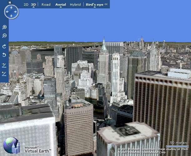

18 3D Cityscapes 18

19 Convergence Enables 3D Urban Simulation Building structure & interior design Mechanical, electrical, & plumbing detail GIS street and parcel information Underground utility data Realistic visualization 19

20 Challenge: Aging Workforce in Utilities and Telcos 20

21 CAD/BIM is a Primary Data Source of Precision Infrastructure Information October
22 As-builts Inefficient Flow of Infrastructure Information Engineering Design (CAD) Construction Drawings Paper Construction Paper Field Force (Linesmen, Troublemen, Install and Repair) Paper Markups Records Records (GIS) October
23 Aging Workforce in the Utility Industry Average age of utility workers is close to 50 By 2010, as many as 60 percent of today s experienced utility workers will retire. Study by American Public Power Assn Aging work force is #1 concern of utility HR executives Survey by Carnegie Mellon University Electricity Industry Center 20 % decline in productivity forecasted Booz Allen study October
24 What is Web 2.0? Web 1.0 Web 2.0 DoubleClick --> Google AdSense Ofoto --> Flickr Akamai --> BitTorrent mp3.com --> Napster Britannica Online --> Wikipedia personal websites --> blogging Evite --> upcoming.org and EVDB Domain name speculation --> search engine optimization Page views --> cost per click Screen scraping --> web services Publishing --> Participation Content management systems --> wikis Directories (taxonomy) --> tagging ("folksonomy") Stickiness --> syndication Source: Tim O Reilly What is Web 2.0? 24
25 As-builts Web 2.0 Enables Field Participation Engineering Design (Geospatial CAD) Workprint Paper Construction Drawings Construction Streamline asbuilts Spatial RDBMS Paper Field Force (Linesmen, Troublemen, Install and Repair) Records Enable field force participation Update Records (Geospatial CAD) October
26 No. of sites Web2.0 Open Source Web Mapping ArcIMS MapServer Web1.0 MapGuide GeoMedia Web MapExtreme Utility and Telecom 26 Government
 Desktop Applications GRASS OSSIM Quantum GIS Metadata Catalog GeoNetwork opensource")
27 Open Source Geospatial Foundation Web Mapping MapServer MapGuide Open Source OpenLayers MapBender MapBuilder Geospatial Libraries GDAL/OGR GeoTools Feature Data Object (FDO) Desktop Applications GRASS OSSIM Quantum GIS Metadata Catalog GeoNetwork opensource 27
28 Web 2.0 Open Source Web Mapping Platform Desktop Applications Web Applications Spatiallyenabled CAD Desktop Fusion MapGuide Open Source Feature Data Object API SDF Shape ArcSDE MySQL Oracle Spatial 28

29 Web 2.0 and the Aging Workforce 29
30 Convergence: First Responders 30

31 What is the Problem? 31


32 What Does a First Responder Need? OUTSIDE INSIDE UNDER 3D exterior urban visualization Including: - Utility structures - Full city blocks of 3D detail - Precise spatial orientation - Line of Sight calculations - Space to Sidewalk view Full interior, 3D visualization Including: - Utility / HVAC systems - Furniture - Mechanized lifts / elevators - Walls, doors, windows - Precision architectural detail 32 3D subterranean visualization Including: - Sewer systems - Utility / Phone systems - Electrical systems - Access routes / portals - Precision CAD detail

33 How Did We Do It? 33

34 Like SIMCity, but with real data 34

35 Convergence: Citizen Communication 35
36 Summary Worldwide challenges: global climate change, aging infrastructure, aging workforce, productivity New technologies are being developed to address these challenges. Convergence is changing the way infrastructure and buildings are being designed, managed, and operated Provides important benefits to utilities, telcos, and government. 36
37 geospatial.blogs.com 37
Developing a Free and Open Source Software based Spatial Data Infrastructure. Jeroen Ticheler
 Developing a Free and Open Source Software based Spatial Data Infrastructure Jeroen Ticheler 1 License This work is licensed under the Creative Commons Attribution-NonCommercial-ShareAlike 2.5 License.
Construction, Smart Grid and Intelligent City Models. Geoff Zeiss Principal Between The Poles
 Construction, Smart Grid and Intelligent City Models Geoff Zeiss Principal Between The Poles Geospatial Media Technologies are evolving rapidly in the $7 trillion annually construction industry Evolution
PGT T3CHNOLOGY SCOUTING. Google Webtoolkit. JSF done right?
 Google Webtoolkit JSF done right? Session topics Web 2.0, Ajax GWT What is it? Java EE and the Web GWT and Java EE JSF done right? Time for a demo? 2 2008 Dipl.-Wing. P. G. Taboada Web 2.0 Hard to define
A Planet of Smarter Cities: Security and critical infrastructures impact
 A Planet of Smarter Cities: Security and critical infrastructures impact Alberto Barrientos Director of Public Sector IBM Smarter Cities Alberto.barrientos@es.ibm.com Urban population growth expected to
Open Source Software Solutions
 Open Source Software Solutions Ned Horning horning@amnh.org http://biodiversityinformatics.amnh.org 1 Overview Introduction to open source software Geospatial software options Open Source Geospatial Foundation
PUBLIC WORKS ORGANIZATIONAL CHART
 PUBLIC WORKS ORGANIZATIONAL CHART C-108 Actual 2012-13 Adopted Year-End Estimated 2014-15 2015-16 PROGRAM EXPENSES/REVENUES Salaries & Benefits $ 1,725,030 $ 1,855,980 $ 1,676,130 $ 1,956,510 $ 1,979,470
Mobile Systeme Grundlagen und Anwendungen standortbezogener Dienste. Location Based Services in the Context of Web 2.0
 Mobile Systeme Grundlagen und Anwendungen standortbezogener Dienste Location Based Services in the Context of Web 2.0 Department of Informatics - MIN Faculty - University of Hamburg Lecture Summer Term
Smart Cities/Smart Buildings
 Smart Cities/Smart Buildings.. A Short Tale of Two Scales James Kavanagh RICS WPLA/CLRKEN workshop 21 st April session 3 Content. A brief introduction to BIM & Smart Cities Smart cities, dumb buildings
BUILDINGS AND FACILITIES
 EB-00-0 Exhibit C Tab Schedule Page of BUILDINGS AND FACILITIES FACILITIES AND ASSET MANAGEMENT OVERALL STRATEGY THESL s buildings and facilities (the facilities ) include operating centers (00 Commissioners,
Open Environment for Design
 Open Environment for Design Open Access Conference Apr 11th, 2006 Sunil Joshi Sr. Vice President, Design Tools, Performance and QA Scalable Systems Group. Agenda Enough said about OpenAccess...... Just
Mapping underground infrastructure: The next frontier of remote sensing
 Mapping underground infrastructure: The next frontier of remote sensing Geoff Zeiss Principal Between Geospatial The Media Poles Cost of unreliable underground utility location Underground utility hit
Coming round the mountain. New challenges ahead for Libraries
 Coming round the mountain New challenges ahead for Libraries What is meant by Web 2.0? First coined somewhere around 2001, the concept of Web 2.0 is an evolution of the old way that we thought about and
ArcGIS 9.2 Works as a Complete System
 ArcGIS 9.2 Works as a Complete System A New Way to Manage and Disseminate Geographic Knowledge Author/Serve/Use Maps Data Models Globes Metadata Use Desktop Explorer Web Map Viewer Mobile Open APIs Enterprise
FDO Data Access Technology at a Glance
 Autodesk Geospatial FDO Data Access Technology at a Glance Work seamlessly with your geospatial data whatever the format 1 The Challenge The growing need for openness and interoperability between traditional
Gold: points Platinum: 80+ points. Certified: points Silver: points
 What is LEED? LEED, or Leadership in Energy & Environmental Design, is redefining the way we think about the places where we live, work and learn. As an internationally recognized mark of excellence, LEED
Web Map Servers. Mark de Blois. Septembre 2016
 Web Map Servers Mark de Blois Septembre 2016 Learning Objectives After this lecture you will be able to understand web map servers as used in Web-GIS applications Introduction A Web Map Server is a computer
FDO Data Access Technology How to add new data sources with Third Party and Open Source FDO Providers
 AUTODESK GEOSPATIAL WHITE PAPER FDO Data Access Technology How to add new data sources with Third Party and Open Source FDO Providers Work seamlessly with your geospatial data whatever the format Autodesk
Establishing the Vision
 BIM & Beyond: USCG Case Studies from Mission to Management Establishing the Vision June 23, 2007 Dana K. Deke Smith, AIA Executive Director, buildingsmart Alliance Setting the Vision $3 Trillion industry
Integrated Grid. Barbara Tyran Executive Director, Government & External Relations. Midwest Energy Policy Conference October 2016
 Integrated Grid Barbara Tyran Executive Director, Government & External Relations Midwest Energy Policy Conference October 2016 Electric Power Research Institute Together Shaping the Future of Electricity
Features and Benefits
 AutoCAD Map 3D 2010 Features and Benefits AutoCAD Map 3D software is a leading engineering solution for creating and managing spatial data. Using open-source Feature Data Object (FDO) technology, AutoCAD
Maximizing the University s Physical Assets (Part I): Facility Condition Assessment
: Facility Condition Assessment") Maximizing the University s Physical Assets (Part I): Facility Condition Assessment Board of Regents Facilities and Operations Committee September 12, 2013 Agenda Program background Broadening our data
Maximizing the University s Physical Assets (Part I): Facility Condition Assessment Board of Regents Facilities and Operations Committee September 12, 2013 Agenda Program background Broadening our data
Bringing Singapore to life in 3D
 Bringing Singapore to life in 3D Dr Victor Khoo, Deputy Director Singapore Land Authority Bringing Singapore to life in 3D ESRI Singapore UC 2016 Dr. Victor Khoo Singapore Land Authority SLA 2016 RESTRICTED
CANADA S FUTURE BUILT ENVIRONMENT: SUSTAINABLE, INNOVATIVE AND RESILIENT. August 3, 2016
 DR CANADA S FUTURE BUILT ENVIRONMENT: SUSTAINABLE, INNOVATIVE AND RESILIENT CCI Recommendations for Federal Budget 2017 August 3, 2016 Executive Summary Canadian Construction Innovations (CCI) welcomes
a) Provision of a chilled water supply b) Provision of electric power supply and other fuels
 Provision of a chilled water supply b) Provision of electric power supply and other fuels") 10.0 UTILITIES ELEMENT The purpose of this element is to ensure coordinated provision of utility services required to meet the future needs of the University, consistent with current efforts to address
10.0 UTILITIES ELEMENT The purpose of this element is to ensure coordinated provision of utility services required to meet the future needs of the University, consistent with current efforts to address
Daniel Akenine Architect, Microsoft
 Daniel Akenine Architect, Microsoft Web 2 - Consumer & Enterprise Beyond web 2 semantic web? Quincy Inhabitants: 5,300 Work: 52% agriculture 18 % building sector 18 % public sector Language: Spanish 57%
EWRG-CES. Bharath Setturu EWRG, CES, IISc
 Bharath Setturu EWRG, CES, IISc What is Free and Open Source? Free and Open source describes a broad general type of free software license that makes source code available to the general public with no
Autodesk Utility Design and Your GIS
 UT4523-P Autodesk Utility Design and Your GIS Prashant Srivastav Quality Assurance Lead, Utilities Co Speakers: Jeff Saunders, Carsten Hess The Power Track Utility Design Power Track at a glance... and
Autodesk Infrastructure Solutions. Autodesk Geospatial Product Line. White Paper
 Autodesk Infrastructure Solutions Autodesk Geospatial Product Line White Paper For many organizations, such as governments, utilities, telecommunication providers, engineering firms, and construction companies,
History and Backgound: Internet & Web 2.0
 1 History and Backgound: Internet & Web 2.0 History of the Internet and World Wide Web 2 ARPANET Implemented in late 1960 s by ARPA (Advanced Research Projects Agency of DOD) Networked computer systems
Canadian Infrastructure Report Card
 Chris McNally, P.Eng. Presentation to the Institute of Intergovernmental Relations June 2015 Project Sponsors: 1 The Problem According to Statistics Canada, the Gross stock of core public infrastructure
Building the Future. New ICT Enables Smart Cities. Yannis Liapis Oct 25 th,
 Building the Future New ICT Enables Smart Cities Yannis Liapis Oct 25 th, 2017 1 Why Do We Need Smart City? Rapid population growth, urbanization acceleration Major issues Global population growth will
Internet of Things Towards a more collaborative model
 i Internet of Things Towards a more collaborative model Brahim GHRIBI Head of Government Relations MEA NOKIA 1 Nokia 2017 Past has been about connecting people, the future is about connecting things Improving
Annual Report for the Utility Savings Initiative
 Report to the North Carolina General Assembly Annual Report for the Utility Savings Initiative July 1, 2016 June 30, 2017 NORTH CAROLINA DEPARTMENT OF ENVIRONMENTAL QUALITY http://portal.ncdenr.org Page
Critical Maintenance for Community Colleges bonded Health and Safety bonded Facilities Preservation bonded
 Section Contents Five-Year Capital Plan FY 2017-18 through FY 2021-22 Project Funding Type Five-Year Plan Total ($ 000s) Critical Maintenance for Community Colleges bonded $235,000 Health and Safety bonded
Hampton Roads Sustainable Living Expo
 Hampton Roads Sustainable Living Expo Exploring the balance between social, economic, and environmental responsibility Virginia Beach Convention Center September 28 29, 2012 Hansen Family Foundation Sustainability
County of Los Angeles. Chief Information Office Preferred Technologies for Geographic Information Systems (GIS) Version 2 May 2015
 Version 2 May 2015") County of Los Angeles Chief Information Office Preferred Technologies for Geographic Information Systems (GIS) Version 2 May 2015 CIO Preferred Technologies for GIS This document lists the preferred Geographic
County of Los Angeles Chief Information Office Preferred Technologies for Geographic Information Systems (GIS) Version 2 May 2015 CIO Preferred Technologies for GIS This document lists the preferred Geographic
Technology Brown Bag: Web 2.0
 Technology Brown Bag: Web 2.0 Schedule information Event Technology Brown Bag: Web 2.0 When Thursday, May 4, 2006 from 12:00pm to 1:30pm Where Harris 1300 Event details Details Access Contact What is Web
Director of Public Works/City Engineer. Secretary. Word Processor. Streets and Facilities Supervisor. Traffic Signal Technician.
 PUBLIC WORKS ORGANIZATIONAL CHART Director of Public Works/City Engineer Secretary Word Processor Transit Services Manager Fleet Services Supervisor Streets and Facilities Supervisor Principal Principal
National Geospatial Data Repository Centralised or Distributed?
 National Geospatial Data Repository Centralised or Distributed? Dr. Aniruddha Roy Vice President Navayuga New Delhi, INDIA Presentation Overview NGDR - Prespective NGDR - Stakeholders Boundary Consistency
OSGeo Web Mapping Typification: GeoMajas, Mapbender, MapFish and OpenLayers. Christoph Baudson Arnulf Christl FOSS4G 2010 Barcelona
 OSGeo Web Mapping Typification: GeoMajas, Mapbender, MapFish and OpenLayers Christoph Baudson Arnulf Christl FOSS4G 2010 Barcelona Disclaimer All information contained in this presentation has been compiled
Egyptian Survey Authority Geographic Information Management System (ESA GIM)
") Egyptian Survey Authority Geographic Information Management System (ESA GIM) Sohail El ABD and Kholoud SAAD, Egypt Key words: GIS, theme, etc. SUMMARY ESA can be regarded as the backbone for supplying
Egyptian Survey Authority Geographic Information Management System (ESA GIM) Sohail El ABD and Kholoud SAAD, Egypt Key words: GIS, theme, etc. SUMMARY ESA can be regarded as the backbone for supplying
Leveraging OGC Standards on ArcGIS Server
 Leveraging OGC Standards on ArcGIS Server Satish Sankaran Interoperability and Standards Team James Michel III ESRI Intel Team ArcGIS Server Complete Interoperable Server-Based GIS Desktop Explorer Web
2011 Bentley Systems, Incorporated. Bentley Descartes V8i Advancing Information Modeling For Intelligent Infrastructure
 Bentley Descartes V8i Advancing Information Modeling For Intelligent Infrastructure Agenda Why would you need Bentley Descartes? What is Bentley Descartes? Advanced Point Cloud Workflows Advanced Terrain
Housekeeping Tips. Access a PDF of the slides, access the speakers bios. Participate in polls
 Housekeeping Tips Access a PDF of the slides, access the speakers bios Participate in polls Ask a question! or send a Tweet at @directionsmag, and include #GoogleWebinar An on-demand recording of today
Web 2.0 Tutorial. Jacek Kopecký STI Innsbruck
 Web 2.0 Tutorial Jacek Kopecký STI Innsbruck SOA4All Kick-off -Madrid, 25th-27th March 2008 Web 2.0 and SOA: Overview Questions to be addressed: What is Web 2.0? What technologies does Web 2.0 comprise?
FOR SALE BANK OWNED OFFICE CENTRAL LAKELAND HISTORIC DISTRICT
 Jack Strollo, Broker 500 S. Florida Avenue, Suite 420 Lakeland, Florida 33801 O. 863.683.3425 x103 C. 863.640.8238 jstrollo@resbroadway.com FOR SALE BANK OWNED OFFICE CENTRAL LAKELAND HISTORIC DISTRICT
Autodesk Geospatial Solutions White Paper
 Autodesk Geospatial Solutions White Paper Introduction For many organizations, such as governments, utilities, telecommunication providers, engineering firms, and construction companies, geospatial data
2018 Capital Budget Presentation
 2018 Capital Budget Presentation 2018 General Capital Budget Expenditures Asset Type 2018 Capital Projects Police 1,431,200 Fire 1,200,000 Finance 37,000 Transportation 8,231,900 Drainage 7,356,000 Parks
1.0 General AUTODESK S ENTRY INTO OPEN SOURCE QUESTIONS AND ANSWERS FOR CUSTOMERS MARCH 2006 UPDATE UPDATES IN BLUE
 AUTODESK S ENTRY INTO OPEN SOURCE QUESTIONS AND ANSWERS FOR CUSTOMERS MARCH 2006 UPDATE UPDATES IN BLUE 1.0 General 1.1 What s the background? In late 2005, several groups, developers and individuals joined
AutoCAD Map 3D and ESRI ArcSDE
 AUTOCAD MAP 3D 2009 WHITE PAPER AutoCAD Map 3D and ESRI ArcSDE Many organizations, such as utilities, telecommunication providers, and government agencies, depend on geospatial data that is stored in a
Government of Canada IPv6 Adoption Strategy. IEEE International Conference on Communications (ICC 12) June 14 th, 2012
 June 14 th, 2012") Government of Canada IPv6 Adoption Strategy IEEE International Conference on Communications (ICC 12) June 14 th, 2012 IPv6 Context The internet is running out of IPv4 addresses now IPv6 is here RIPE NCC
Government of Canada IPv6 Adoption Strategy IEEE International Conference on Communications (ICC 12) June 14 th, 2012 IPv6 Context The internet is running out of IPv4 addresses now IPv6 is here RIPE NCC
Stir It Up: Achieving GIS Interoperability
 Stir It Up: Achieving GIS Interoperability City of Tacoma, Washington, USA Mike Murnane, Community & Economic Development John Shell, Public Works 2006 ESRI International User Conference - August 9, 8:30
Oracle Spatial A Unifying Framework at the Utah Department Of Transportation
 Oracle Spatial A Unifying Framework at the Utah Department Of Transportation Dan Paske Utah Department of Transportation Oracle DBA Jeff Saunders Farallon Geographics, Inc. Senior Geodatabase Developer
Cisco Smart+Connected Communities
 Brochure Cisco Smart+Connected Communities Helping Cities on Their Digital Journey Cities worldwide are becoming digital or are evaluating strategies for doing so in order to make use of the unprecedented
The Most Comprehensive Solution for Indoor Mapping Applications
 The Most Comprehensive Solution for Indoor Mapping Applications TRIMBLE INDOOR MOBILE MAPPING SOLUTION TRIMBLE INDOOR MOBILE MAPPING SOLUTION (TIMMS): HIGH EFFICIENCY, MAXIMUM FLEXIBILITY, ALL-IN-ONE PACKAGE
5G Security. Jason Boswell. Drew Morin. Chris White. Head of Security, IT, and Cloud Ericsson North America
 5G Security Jason Boswell Head of Security, IT, and Cloud Ericsson North America Drew Morin Director Federal Cybersecurity Technology and Engineering Programs T-Mobile USA Chris White Head of Algorithms,
Web 2.0. Boot the computers in 5 th generation with WEB 2.0
 Boot the computers in 5 th generation with WEB 2.0 It was all about the hardware till 4 th generation. Now the responsibility is more on Software to take computers to next generation. We have lived in
Database Driven Web 2.0 for the Enterprise
 May 19, 2008 1:30 p.m. 2:30 p.m. Platform: Linux, UNIX, Windows Session: H03 Database Driven Web 2.0 for the Enterprise Rav Ahuja IBM Agenda What is Web 2.0 Web 2.0 in the Enterprise Web 2.0 Examples and
Questions and Answers
 AUTODESK MAP 3D 2006 Questions and Answers 1. General Product Information 1.1 What is Autodesk Map 3D 2006 software? Autodesk Map 3D 2006, built on AutoCAD 2006 software, connects CAD, civil engineering,
Managing the financial, economic and social impact of extreme weather and climate change EXHIBITOR PROSPECTUS. Organised by: Co-located with:
 Managing the financial, economic and social impact of extreme weather and climate change EXHIBITOR PROSPECTUS Organised by: Co-located with: THE CHALLENGE Some 4 billion people or 54% of the world s population
BIM for infrastructure make easy with Laser Scanner. 17 October Beng Chieh Quah Head of Marketing Asia Pacific
 BIM for infrastructure make easy with Laser Scanner 17 October 2016 Beng Chieh Quah Head of Marketing Asia Pacific who is? founded in 1981 NASDAQ since 1997 Global technology company Offering a range of
Traverse City Asset Management Plan
 Utilities and Public Services Larry LaCross, GISP, Asset Management/GIS Analyst Traverse City Department of Public Services Introduction About Traverse City (TC) TC Assets Department of Public Services
City of Toronto Accessibility Design Guidelines 2015
 RE: DI3.2 City of Toronto Accessibility Design Guidelines 2015 Update to Disability Issues Committee Presented By: Facilities Management Division June 2 nd, 2015 Presenters: Sunil Sharma, General Manager,
ENGINEERING AND CONSTRUCTION BULLETIN
 ENGINEERING AND CONSTRUCTION BULLETIN No. 2018-7 Issuing Office: CECW-EC Issued: 06 Jun 18 Expires: 06 Jun 20 SUBJECT: Advanced Modeling Requirements on USACE Projects CATEGORY: Directive and Policy 1.
A Framework of Information Technology for Water Resources Management
 A Framework of Information Technology for Water Resources Management P.S.V.S. Sridhar T. N. Jowhar Wadia Institute of Himalyan Geology, Anant Bhaskar Garg U. Kedareswarudu ABSTRACT The use of the information
Implementing Web GIS Solutions
 Implementing Web GIS Solutions using open source software Karsten Vennemann Seattle Talk Overview Talk Overview Why and What What is Open Source (GIS)? Why use it? Application Components Overview of Web
Opportunities and Obstacles for Enabling the Use of Geospatial Applications
 Session 2B: Geospatial Knowledge Platforms: Empowering the SDGs through geographic tools and services Opportunities and Obstacles for Enabling the Use of Geospatial Applications Krystal Wilson Secure World
The Critical Role of Emergency Telecommunications and ICTs: Impacts of Natural and Man-made Disasters
 The Critical Role of Emergency Telecommunications and ICTs: Impacts of Natural and Man-made Disasters 8th Symposium on ICTs, the Environment and Climate Change First Meeting of the Focus Group on Smart
Seoul e-government Policies & Strategies. Information System Planning Bureau
 Seoul e-government Policies & Strategies Information System Planning Bureau > About Seoul No.6 Ranked 6th in Urban Competitiveness Worldwide ( 15) 90% More than 90% of Seoul citizens are Smart Phone Users
Building Resilience to Disasters for Sustainable Development: Visakhapatnam Declaration and Plan of Action
 Building Resilience to Disasters for Sustainable Development: Visakhapatnam Declaration and Plan of Action Adopted at the Third World Congress on Disaster Management Visakhapatnam, Andhra Pradesh, India
Web Mapping Illustrated: Using Open Source GIS Toolkits By Tyler Mitchell READ ONLINE
 Web Mapping Illustrated: Using Open Source GIS Toolkits By Tyler Mitchell READ ONLINE If you are searched for a ebook Web Mapping Illustrated: Using Open Source GIS Toolkits by Tyler Mitchell in pdf format,
GIS Solutions for Location-Based Services
 GIS Solutions for Location-Based Services GIS Solutions for Location-Based Services As the global community becomes increasingly more mobile, locating people, places, and things and subsequently deriving
THE REGIONAL MUNICIPALITY OF YORK
 THE REGIONAL MUNICIPALITY OF YORK Committee of the Whole Report of the Executive Director, Corporate and Strategic Planning ECONOMIC DEVELOPMENT ACTION PLAN UPDATE - YORK REGION BROADBAND STRATEGY PROGRESS
The Cost of Information Loss
 The Cost of Information Loss Merrick & Company recently had the opportunity to calculate the predicted return on investment (ROI) for a long term asset lifecycle management implementation of a new facility
Environmental Sustainability
 Environmental Sustainability Smart Applications to support future growth and care for the environment Michalis Grigoratos, EMEA Delivery Lead Energy and Sustainability Management, Hewlett-Packard Company
Smart Cities/Smart Buildings
 Smart Cities/Smart Buildings.. A Tale of Two Scales Tony Mulhall, Geospatial/UNECE Associate Director RICS Lisbon 2015 Smart City (Space syntax UCL) Building (Ghafari/AR) Cultural differences Ensuring
Raster Serving with ArcGIS
 Raster Serving with ArcGIS Agenda Introduction to server technology Workflow considerations ESRI raster serving technology ArcGIS Server Basic (ArcSDE) ArcGIS Server Standard/Advanced Web Services ArcGIS
Modernizing California State Highway Right of Way Records with GIS. Caltrans District 4 Oakland, CA
 Modernizing California State Highway Right of Way Records with GIS Caltrans District 4 Oakland, CA About Us Kirsten Lawrence (GISP), Senior Geospatial Analyst on staff augmentation contract with Caltrans
USE CASE STUDY. Connecting Data Through Mission. Department of Transportation (DOT) A Product of the Federal CIO Council Innovation Committee
 A Product of the Federal CIO Council Innovation Committee") USE CASE STUDY Connecting Data Through Mission Department of Transportation (DOT) A Product of the Federal CIO Council Innovation Committee USE CASE STUDY: Department of VERSION Transportation 1.0 / 2015
USE CASE STUDY Connecting Data Through Mission Department of Transportation (DOT) A Product of the Federal CIO Council Innovation Committee USE CASE STUDY: Department of VERSION Transportation 1.0 / 2015
 http://ipafloods.mydewetra.org 1 My Dewetra IPA FLOODS FLOOD RISK Information System Support the Approximation of EU Floods Directive Compliancy with International standards (INSPIRE, OGC) and protocols
Using the Network Common Data Form for storage of atmospheric data
 Using the Network Common Data Form for storage of atmospheric data Maarten Plieger Royal Netherlands Meteorological Institute The NetCDF4 data format (Network Common Data Form) is used within the ADAGUC
CITY COUNCIL AGENDA REPORT
 CITY COUNCIL AGENDA REPORT Subject: AUMA RESOLUTION BROADBAND INTERNET Recommendation(s) That the AUMA Broadband Resolution 2016, provided as Attachment 1 to the May 24, 2016 report entitled AUMA Resolution
Introduction to the NYISO
 Introduction to the NYISO Power Control Center Guilderland, NY July 21, 2011 1 Today s Topics NYISO History NYISO Roles & Governance NYISO Markets Building Reliability Emerging Trends 2 Evolution of the
Geospatial Enterprise Search. June
 Geospatial Enterprise Search June 2013 www.voyagersearch.com www.voyagersearch.com/demo The Problem: Data Not Found The National Geospatial-Intelligence Agency is the primary source of geospatial intelligence
ESRI-Supported Open Geospatial Consortium, Inc., and ISO/TC 211 Standards
 ESRI-Supported Open Geospatial Consortium, Inc., and ISO/TC 211 Standards An ESRI White Paper June 2008 ESRI 380 New York St., Redlands, CA 92373-8100 USA TEL 909-793-2853 FAX 909-793-5953 E-MAIL info@esri.com
Reliability & Resiliency in the US Capitol Region/Hardening the Grid One Year after Hurricane Sandy
 1 Reliability & Resiliency in the US Capitol Region/Hardening the Grid One Year after Hurricane Sandy 2 Pepco D.C. Distribution System 260,000 Customers 175,000 Customers Supplied by Underground System
Does Your Data Have Harmony. Dan Stone
 Does Your Data Have Harmony Dan Stone Agenda Introduction Configuration Patterns Implementation Approaches Your Feedback ArcGIS for Local Government Esri solutions for local government customers Series
The PICES Metadata Federation: Pacific-wide marine metadata discovery, management and delivery for FUTURE
 PICES 17th Annual Meeting Dalian, People s Republic of China October 30, 2008 The PICES Metadata Federation: Pacific-wide marine metadata discovery, management and delivery for FUTURE S. Allen Macklin
Establishing a Geospatial EnvironmentChapter1:
 Chapter 1 Establishing a Geospatial EnvironmentChapter1: The lessons in this chapter describe working with the SDF format, and feature sources such as raster and ODBC points. Feature sources can be both
Building cyber security
 THE LEADER IN SMART BUILDING SERVICES CONSULTING ON OVER $2 BILLION IN NEW DEVELOPMENT CUSTOMERS WITH OVER 2 BILLION SQUARE FEET Building cyber security Content 05 06 09 10 11 our company who is intelligent
Michigan State University Engineering Lecture Smart Communities October 24 th, 2018 Kerstin Shestin Wilson Performance Infrastructure Account
 Michigan State University Engineering Lecture Smart Communities October 24 th, 2018 Kerstin Shestin Wilson Performance Infrastructure Account Executive Melissa Cole-Ansell Branch Construction Sales Manager
Open to the World. Dr. Anne Haglund-Morrissey Senior Policy Officer - Japan Desk DG Research and Innovation
 Open to the World Dr. Anne Haglund-Morrissey Senior Policy Officer - Japan Desk DG Research and Innovation What is Horizon 2020? Horizon 2020 is the EU Framework Programme for Research & Innovation and
Introducing Quantum GIS. Tim Sutton QGIS Release Manager and Developer
 Introducing Quantum GIS Tim Sutton QGIS Release Manager and Developer tim@linfiniti.com http://linfiniti.com What is QGIS? A Free, Open Source Desktop GIS application A set of developer libraries for building
GEOSPATIAL ERDAS APOLLO. Your Geospatial Business System for Managing and Serving Information
 GEOSPATIAL ERDAS APOLLO Your Geospatial Business System for Managing and Serving Information ERDAS APOLLO Do you have large volumes of data, a geographicallydistributed user base and rapidly changing
IMAGINE Objective. The Future of Feature Extraction, Update & Change Mapping
 IMAGINE ive The Future of Feature Extraction, Update & Change Mapping IMAGINE ive provides object based multi-scale image classification and feature extraction capabilities to reliably build and maintain
Chicago Energy Benchmarking
 Chicago Energy Benchmarking USGBC Missouri Gateway Chapter February 2016 Kathryn Eggers Benchmarking Program Lead 2015 Elevate Energy We promote smarter energy use for all. We give people the resources
Using AutoCAD Map 3D to Solve Real World Issues
 Using AutoCAD Map 3D to Solve Real World Issues Written by: Steve Skarbowski, Synergis Engineering Design Solutions Geospatial Solutions Engineer Let us imagine that we have a tank farm located in a highly
Do More. Change the world in 3D. AutoCAD. Civil 3d
 Do More. Change the world in 3D. AutoCAD Civil 3d 2010 A Powerful Building Information Modeling Solution for Civil Engineering AutoCAD Civil 3D software supports an integrated process focused on a coordinated
FACILITY SERVICES UILDINBUILDG
 FACILITY SERVICES UILDINBUILDG PROGRAM MAP Facilities, Real Estate & Environment and Energy Facilities Management Real Estate Environment & Energy Custodial Care Appraise Property Research & Policy Development
The Oracle Enterprise Geodatabase (EGDB) Charlie Crocker Farallon Geographics, Inc.
 Charlie Crocker Farallon Geographics, Inc.") The Oracle Enterprise Geodatabase (EGDB) Charlie Crocker Farallon Geographics, Inc. www.fargeo.com Norcal URISA Chapter Meeting 2/9/2005 Todays Goals Enterprise geodatabase defined Roles Oracle can play
The Oracle Enterprise Geodatabase (EGDB) Charlie Crocker Farallon Geographics, Inc. www.fargeo.com Norcal URISA Chapter Meeting 2/9/2005 Todays Goals Enterprise geodatabase defined Roles Oracle can play