VIY 3. Series Ground Penetrating Radars
|
|
|
- Branden Horace Greene
- 5 years ago
- Views:
Transcription


1 VIY 3 Series Ground Penetrating Radars
 technologies since 1998.")


2 Transient Technologies LLC is a leading Ukrainian developer and manufacturer of Ground Penetrating Radar (GPR) equipment. Company s engineers have been leading the research and development in the field of ultra-wide band (UWB) technologies since Transient Technologies progressive manufacturing and the vast technical experience of our staff both ensure the best solutions for searching for underground items and nondestructive subsurface inspection considering all the most exacting demands of our customers. Our representatives from 16 countries provide distribution and ensure full technical support of GPR products of Transient Technologies LLC. Innovative technologies being used in design of our GPR equipment and its reliability allowed our products to become the one of the most recognizable brand among worlds leading GPR manufacturers and to create such outstanding Ground Penetrating Radars as VIY 3 series.
3 VIY 3 series Ground Penetrating Radars (GPR) are devices for nondestructive investigation. They allow user to reduce substantially costs and time for geological examination before digging or building activity. In many cases, including cavities detection or plastic pipelines location, other methods or instruments cannot be the same effective. Main advantages Monoblock antennas in durable fiberglass housing All antenna units are bistatic and shielded Telbin original signal processing technology that significantly increases signal/noise ratio along with high sounding speed Separate Control Unit is not required. Antenna unit is directly connected to any Windows computer by single USB cable WiFi connection with antenna unit is provided without any extra equipment All collected data are processed in computer. Errors can be corrected at any moment, original data are kept unchangeable Universal foldable handcart is compatible with VIY3-300, VIY3-500 and VIY3-700 GPR Antenna units are equipped with built-in inclinometers. This allows the user to perform topographic correction with one click External GPS receiver can be directly connected to antenna unit Our software is free of charge!

 Spatial resolution, better than, meters 1.")
4 3 VIY3-125 GPR SPECIFICATIONS Antenna frequency, MHz 125 Analogue-to-Digital Converter range, bits 18 Dynamic range, no less than, db 135 Data acquisition rate, traces per second up to 55 Survey window, nsec 120, 180, 240, 300 Maximum number of samples per trace 1000 Trace stacking number up to 300 Depth of sounding, meters up to 15.0 (determined by soil properties) Spatial resolution, better than, meters 1.0 Trigger modes single, internal, external Maximum size of profile, traces up to Interface USB2 or WiFi Build-in inclinometer yes Dimensions (L x W x H), mm 1105 х 580 х 232 Weight, kg 25.0 Operating temperature range, С Operating time, at least, hours 8


5 15 m 1,0 m 25 8 kg mm 580 mm

6 5 VIY3-300 GPR SPECIFICATIONS Antenna frequency, MHz 300 Analogue-to-Digital Converter range, bits 18 Dynamic range, no less than, db 135 Data acquisition rate, traces per second up to 55 Survey window, nsec 66, 100, 133, 166 Maximum number of samples per trace 1000 Trace stacking number up to 300 Depth of sounding, meters up to 8.0 (determined by soil properties) Spatial resolution, better than, meters 0.3 Trigger modes single, internal, external Maximum size of profile, traces up to Interface USB2 or WiFi Build-in inclinometer yes Dimensions (L x W x H), mm 610 х 312 х 170 Weight, kg 9.0 Operating temperature range, С Operating time, at least, hours 8


7 8 m 0,3 8 9 kg mm 312 mm

 Spatial resolution, better than, meters 0.")
8 7 VIY3-500 GPR SPECIFICATIONS Antenna frequency, MHz 500 Analogue-to-Digital Converter range, bits 18 Dynamic range, no less than, db 135 Data acquisition rate, traces per second up to 55 Survey window, nsec 32, 50, 64, 80 Maximum number of samples per trace 1000 Trace stacking number up to 300 Depth of sounding, meters up to 4.0 (determined by soil properties) Spatial resolution, better than, meters 0.18 Trigger modes single, internal, external Maximum size of profile, traces up to Interface USB2 or WiFi Build-in inclinometer yes Dimensions (L x W x H), mm 325 х 210 х 156 Weight, kg 2.5 Operating temperature range, С Operating time, at least, hours 8


9 4,0 m 0,18 2,5 8 kg mm 210 mm

10 9 VIY3-700 GPR SPECIFICATIONS Antenna frequency, MHz 700 Analogue-to-Digital Converter range, bit 18 Dynamic range, no less than, db 135 Data acquisition rate, traces per second up to 55 Survey window, nsec 16, 24, 32, 40 Maximum number of samples per trace 1000 Trace stacking number up to 300 Depth of sounding, meters up to 2.5 (determined by soil properties) Spatial resolution, better than, meters 0.12 Trigger modes single, internal, external Maximum size of profile, traces up to Interface USB2 or WiFi Build-in inclinometer yes Dimensions (L x W x H), mm 325 х 210 х 156 Weight, kg 2.5 Operating temperature range, С Operating time, at least, hours 8


11 2,5 m 0,12 2,5 8 kg mm 210 mm


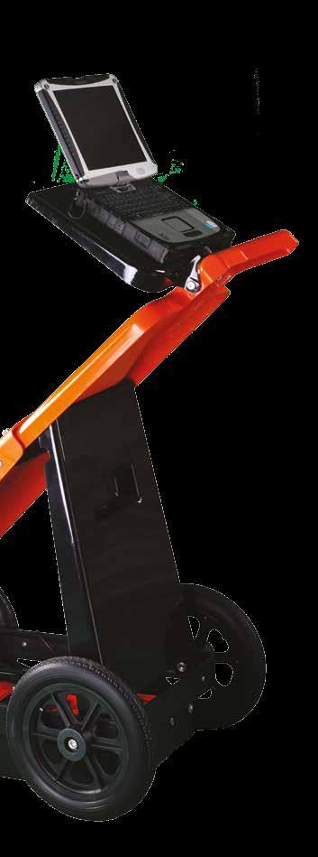
12 11 CART-36 Handcart SPECIFICATIONS CART-36 foldable handcart allows operator to carry out quick inspection of large landfills. It is compatible with VIY3-300, VIY3-500 and VIY3-700 GPR Durable and reliable construction. Dustproof and waterproof design Universal shelf for laptop Built-in bidirectional odometer Compact when folded Large 12 inch wheels Dimensions Operating position (L x W x H), mm 970 x 500 x 1000 Folded position (L x W x H), mm 885 x 500 x 320 Weight, kg 15.0


13 mm 1000 mm 500 mm


14 13 Software VIY3 Software Package allows the User to carry out all necessary works with GPR: sounding, data acquisition and post-processing, data display on plan or map, 3D representation and report creation. VIY3 Software Package includes two programs working together Synchro and Planner. Synchro Planner

15 SYNCHRO 14 Synchro the software designed for: working with GPR during data acquisition setting all necessary GPR presets data-processing saving obtained data Information window of GPR profile Multiple-window interface Display GPR type, sounding presets, topographic info Axes of time, depth and distance Flexible display setup Scaling Proportions change


16 15 SYNCHRO Control of GPR operation Setting of GPR parameters Start/stop of sounding process Set-up of mutual profiles location Maximum movement speed control

17 Software 16 Data-processing 12 tools (including 1D and 2D) Flexible tools settings Easy-to-use tools Prepared for use presets Saving raw GPR data Interactive display of the result of the tool on the profile


18 17 SYNCHRO Markers Two kinds of markers: surface and object ones Marker manager Surface Markers: Name of Marker Trace number Coordinates of Position Object Marker: Name of Marker Trace number Coordinates of Marker position (depth, time)

19 Software 18 Palettes Easy-to-use palettes library Interactive palette editing by the User Export Export to main graphic formats including all axes and markers Export to SEG-Y Export to CSV Available languages

20 19 PLANNER Planner the software designed to display GPR data and underground objects on plan or map. Planner is inseparably linked with Synchro. GPR data can be displayed in 3D view or as sections on different planes Profile displaying Simultaneous display of several GPR profiles with scrolling by depth and distance Unlimited number of profiles in a site and sites in a project Mapping of X, Y coordinates and depth of current cursor position on the profile Arbitrary placement of profiles Displaying of profiles in depending on angle of intersection with baseline Simultaneous display of profiles obtained from different antenna units Setting of azimuths or relative angles for profiles


21 Software 20 Object manager Easy-to-use object tree for quick selection of site, profile and marker Color display of selected and adjacent profiles Project statistics: displaying of number of sites and profiles, total length of profiles Markers Two kinds of markers: surface and object ones Marker manager Displaying of markers on the plan, GPR profile and 3D view Mapping Convenient display of profiles on the plan by arrows Color display of selected and adjacent profiles Displaying of cursor coordinates Zoom and pan Map usage as background layer for project


22 21 PLANNER 3D view Auto setting of interpolation parameters with optional manual setup 3D data displaying and rotating The interpolation can be built by any profile section and project plane No extra software is necessary Marker size adjustment Buttons of auto positioning: top view, left view, right view, front view, isometric view etc. Making reports with 3D view
23 Software 22 Interpolation for 3D view can be made with any data set different GPR presets, types of antenna unit, orientation of profiles Reports Creating of the report image with all needed area of the plan including added graphic elements legend, figures and lines Making unlimited number of reports in the project Wide opportunities of reports editing Report export into graphic format for the further usage in other documents Export of the project s data into DXF format Export of the project s data into AutoCad format in relative or absolute coordinates Export of markers into DXF format with saving of color, position and depth setting Available languages
 240-85-94 e-mail: info@viy.ua www.")
24 Transient Technologies LLC office 604, 13 Evgena Sverstuka str. Kyiv 02660, Ukraine Phone: +380 (44)
VIY 3 Ground Penetrating Radars
 VIY 3 Ground Penetrating Radars Synchro ver 3.9.1.24 User Manual Series 3 Transient Technologies 2004 2017 Transient Technologies LLC office 604, 13, Evgena Sverstuka str., Kyiv 02660, Ukraine Phone: +380
UtilityScan TM. Locate and Map Underground Utilities with GPR. Typical Uses. Designate Targets.
 UtilityScan TM Locate and Map Underground Utilities with GPR UtilityScan is the industry standard ground penetrating radar solution for the designation of subsurface utilities. With UtilityScan, users
by Sensors & Software Inc.
 by Sensors & Software Inc. subsurface imaging solutions NOGGIN Noggin subsurface imaging instruments are a fast, affordable and easy-to-use family of Ground Penetrating Radar (GPR) systems from Sensors
NOGGIN ADAPTABLE, HIGH-PERFORMANCE GROUND PENETRATING RADAR
 NOGGIN ADAPTABLE, HIGH-PERFORMANCE GROUND PENETRATING RADAR NOGGIN Adaptable, proven GPR to solve today s problems Noggins are available in four center frequencies, ranging from 100 MHz for deep penetration
Terraplus Inc. 52 West Beaver Cr. Rd. #12, Richmond Hill, ON. Canada L4B 1L9. Tel: Fax:
 Outstanding data quality, exceptional performance and WiFi option The GroundExplorer (GX) is based on innovative, patent-pending High Dynamic Range (HDR) technology and represents a leap forward in Ground
RD Ground Penetrating Radar. Portable rugged GPR for the utility industry
 Ground Penetrating Radar RD1000 + Ground Penetrating Radar Portable rugged GPR for the utility industry RD1000+ Utility GPR The RD1000+ Ground Penetrating Radar is a powerful complement to Radiodetection
EKKO_Project POWERFUL, INTUITIVE GPR DATA DISPLAY, ANALYSIS & REPORTING SOFTWARE
 TM EKKO_Project POWERFUL, INTUITIVE GPR DATA DISPLAY, ANALYSIS & REPORTING SOFTWARE EKKO_Project From field to finished report Once the Ground Penetrating Radar (GPR) data collection in the field is complete,
EKKO_Project POWERFUL, INTUITIVE GPR DATA DISPLAY, ANALYSIS & REPORTING SOFTWARE
 EKKO_Project TM POWERFUL, INTUITIVE GPR DATA DISPLAY, ANALYSIS & REPORTING SOFTWARE EKKO_Project From field to finished report Once the Ground Penetrating Radar (GPR) data collection in the field is complete,
The 2003/4 includes: Ground Penetrating Radar Detector, Joystick to manually transmit pulses, computer cable for
 See into the Ground The Future Series ground penetrating radar is a non-invasive electromagnetic geophysical technique for identifying and mapping in subsurface exploration. Also know n as Georadar, Subsurface
The principles of CCTV design in VideoCAD
 The principles of CCTV design in VideoCAD By Stanislav Utochkin, cctvcad.com CCTV focus readers have already had an opportunity to read about VideoCAD in the past issues. This is the only specialised program
Cross hairs for vertical and horizontal profiles. Profile can be linked to cross hair position, centroid, peak or sum profile can be displayed
 3.1.2 Laser Beam Analysis Systems 3.1.2.2 BeamStar Greatest ease of use Automated operation Effortless report generation Start/stop measurement Background subtraction for improved accuracy measurements
Engineering Geology. Engineering Geology is backbone of civil engineering. Topographic Maps. Eng. Iqbal Marie
 Engineering Geology Engineering Geology is backbone of civil engineering Topographic Maps Eng. Iqbal Marie Maps: are a two dimensional representation, of an area or region. There are many types of maps,
3GSM GmbH. Plüddemanngasse 77 A-8010 Graz, Austria Tel Fax:
 White Paper Graz, April 2014 3GSM GmbH Plüddemanngasse 77 A-8010 Graz, Austria Tel. +43-316-464744 Fax: +43-316-464744-11 office@3gsm.at www.3gsm.at Measurement and assessment of rock and terrain surfaces
Object Mapper Operating Manual Version
 Object Mapper 2018 Operating Manual Version 2.0 12.01.18 Table of Contents Operating Manual....1 1 Introduction.......3 2 Object Mapper Tutorial...5 3 Main Menu... 11 3.1 File........11 3.2 View.....12
AKELA Vector Network Analyzer (VNA) Quick Start Guide
 Quick Start Guide") AKELA Vector Network Analyzer (VNA) Quick Start Guide Copyright AKELA, Inc. 2012, all rights reserved http:\\akelainc.com LabVIEW and LabWindows are registered trademarks of National Instruments Incorporated
AKELA Vector Network Analyzer (VNA) Quick Start Guide Copyright AKELA, Inc. 2012, all rights reserved http:\\akelainc.com LabVIEW and LabWindows are registered trademarks of National Instruments Incorporated
Magnetic Field Mapping System MMS-1-RS KEY FEATURES:
 KEY FEATURES: Maximal Scanning volume (X x Y x Z): - standard: 135 x 135 x 135 mm 3 - optional: 500 x 500 x 135 mm 3 Scanning speed: - standard: adjustable, up to 50 mm/s - optional: adjustable, up to
RST INSTRUMENTS LTD.
 RST INSTRUMENTS LTD. Digital Spiral Probe Instruction Manual Ltd. 200 2050 Hartley Avenue Coquitlam, B.C. Canada V3K 6W5 Tel: (604) 540-1100 Fax: (604) 540-1005 Email: Info@rstinstruments.com i Digital
User s guide December 2011
 User s guide User s guide December 2011 WARNINGS In writing this manual every care has been taken to offer the most updated, correct and clear information possible; however unwanted errors are always
Electromagnetic Wire Rope Inspection System LMA-TEST (USB) Specification Sheets
 Specification Sheets") Electromagnetic Wire Rope Inspection System LMA-TEST (USB) Specification Sheets Clockwise: LMA-450, LMA-250, LMA-175L, LMA-75, LMA-125 Sensor Heads CC-04-USB Signal Console SPECIFICATION SHEET USB Computer
Electromagnetic Wire Rope Inspection System LMA-TEST (USB) Specification Sheets Clockwise: LMA-450, LMA-250, LMA-175L, LMA-75, LMA-125 Sensor Heads CC-04-USB Signal Console SPECIFICATION SHEET USB Computer
EFC-400 Release 2006 now with added cartographic function features
 EFC-400 Release 2006 now with added cartographic function features Overview of the new features: Ground profiles with up to 5000 x 5000 points Storage of sets of cartographic test data New components added
GPR DATA ANALYSIS OF AIRFIELD RUNWAY USING MIGRATION VELOCITY SIMULATION ALGORITHM
 GPR DATA ANALYSIS OF AIRFIELD RUNWAY USING MIGRATION VELOCITY SIMULATION ALGORITHM Ramya M and Krishnan Balasubramaniam Centre for Nondestructive Evaluation, Department of Mechanical Engineering, Indian
FGPS International DWC-LLC
 FGPS International DWC-LLC DWC Business Centre, Dubai Aviation City - Logistics City, Dubai, UAE,. PO BOX 390667 Tel: +44 (0)7793 611932 Email: office@fgps.com Web: www.fgps.com P1Tools OPERATION MANUAL
Auto Pan Preset position Position feedback Endless Pan rotation Absolute position Go-To
 United Vision Solutions, LLC 10 Center St., Suite 401&402, Chicopee, Ma 01013 USA 413-592-8477 413-591-8477 sales@unitedvisionsolutions.com EV3000 Series A world without Darkness High speed rotation pan
ME scope Application Note 36 ODS & Mode Shape Animation
 Requirements for Animation ME scope Application Note 36 ODS & Mode Shape Animation The following steps are required in order to display shapes in animation on a structure model, 1. Create a Structure Model
Target Lithology Voxels
 Target Lithology Voxels The Target Lithology Voxels tool enables you to create a 3D grid (voxel) based on data contained in a string channel within a from-to drillhole database. A lithology voxel can be
Smart Fieldmeter Digital Specification
 Smart Fieldmeter Digital Specification Smart Fieldmeter Digital (SFD): Electromagnetic field monitor having flexible and expandable architecture, state of the art design with convenience and simplicity
ScienceGL 3D DredgePRO.
 ScienceGL 3D DredgePRO. 3D DredgePRO is a software package specifically developed to provide analytical and 3D visualization capabilities through various stages of dredging projects. In general, dredging
User s guide. November LSE S.r.l. All rights reserved
 User s guide November 2015 2015 LSE S.r.l. All rights reserved WARNING In writing this manual every care has been taken to offer the most updated, correct and clear information possible; however unwanted
X PAD Construction 2.5.5
 News X PAD Construction January 2014 X PAD Construction 2.5.5 This document contains a list of all changes, new features, bug fixed introduced in this last version of X PAD Construction. GPS RTCM3.1: RTCM3.1
User s guide. November LSE S.r.l. All rights reserved
 User s guide November 2016 2016 LSE S.r.l. All rights reserved WARNING In writing this manual every care has been taken to offer the most updated, correct and clear information possible; however unwanted
ULTRASONIC LOW-FREQUENCY TOMOGRAPH А1040 MIRA OPERATION MANUAL
 ULTRASONIC LOW-FREQUENCY TOMOGRAPH А1040 MIRA OPERATION MANUAL Acoustic Control Systems, Ltd. Moscow 2015 Contents 1. The general Instructions... 5 1.1 PURPOSE of the device... 5 1.1.1 Purpose and field
MARS v Release Notes Revised: May 23, 2018 (Builds and )
") MARS v2018.0 Release Notes Revised: May 23, 2018 (Builds 8302.01 8302.18 and 8350.00 8352.00) Contents New Features:... 2 Enhancements:... 6 List of Bug Fixes... 13 1 New Features: LAS Up-Conversion prompts
MARS v2018.0 Release Notes Revised: May 23, 2018 (Builds 8302.01 8302.18 and 8350.00 8352.00) Contents New Features:... 2 Enhancements:... 6 List of Bug Fixes... 13 1 New Features: LAS Up-Conversion prompts
CS8800 WALKING PROFILER
 CS8800 WALKING PROFILER Overview CS8800 Design and Measurement Method Operational Procedures Recent and Pending Enhancements Base Price & Options Comments on October 20009 FHWA Collections CS8800 DESIGN
Data logger. Overview. PDF created with FinePrint pdffactory trial version
 Data logger Overview The PC control software now includes a data logger that can record 8 channels of information from the ECU. Selecting Data logger from the Graph drop down menu accesses the data logger
Screenshots related to release of Panasonic VRF v New indoor unit models and also fixed indoor unit calculations in case of ECOi systems
 Screenshots related to release of Panasonic VRF v7.16.0 New indoor unit models and also fixed indoor unit calculations in case of ECOi systems Same system but mounting scheme Calculations of SCOP/SEER
v Getting Started An introduction to GMS GMS Tutorials Time minutes Prerequisite Tutorials None
 v. 10.3 GMS 10.3 Tutorial An introduction to GMS Objectives This tutorial introduces GMS and covers the basic elements of the user interface. It is the first tutorial that new users should complete. Prerequisite
PSA-Manager Version 3 User Manual
 PSA-Manager Version 3 User Manual CONTENTS 1 Introduction...2 2 File Types and Locations...3 3 PSA-Manager Windows...4 4 Viewing Trace Files...7 4.1.1 The Trace Memo sub-window...8 4.1.2 Printing Trace
Getting Started. What is SAS/SPECTRAVIEW Software? CHAPTER 1
 3 CHAPTER 1 Getting Started What is SAS/SPECTRAVIEW Software? 3 Using SAS/SPECTRAVIEW Software 5 Data Set Requirements 5 How the Software Displays Data 6 Spatial Data 6 Non-Spatial Data 7 Summary of Software
FS Future Serie. FS-Thermoscan. User s manual
 FS Future Serie FS-Thermoscan 8 User s manual User s manual: FS-Thermoscan 2 Any information contained in these operating instructions may be changed without prior notice. OKM does not make any warranty
HuddleCamHD RS-232 Joystick Controller Model Number: HC-JOY
 HuddleCamHD RS-232 Joystick Controller Model Number: HC-JOY JOYSTICK KEYBOARD INSTALLATION & OPERATION MANUAL Rev 1.0 6/15 Easy pan, tilt & zoom controls for any RS-232 VISCA protocol camera! Controls
RD1100 & RD1500 Ground Penetrating Radar. Complete range of utility-locating radars
 RD1100 & RD1500 Ground Penetrating Radar Complete range of utility-locating radars Radiodetection s RD1100 & RD1500 Ground Penetrating Radar Innovative tools for finding buried utilities Geo-referenced
MarShaft. MarShaft SCOPE 250 plus
 + MarShaft MarShaft SCOPE 250 plus Flexible shaft measuring machine for measuring small, rotationally symmetrical workpieces such as turned parts Use in production Fast and easy operation Maximum measuring
Welcome to The Discovery Series Quantity One 1-D Analysis Software
 Bulletin 2908 US/EG Rev A Imaging Products Division Bio-Rad Laboratories Life Science Group Welcome to The Discovery Series Quantity One 1-D Analysis Software Version 4.4 Update Training Guide Bio-Rad
PixHawk and Marvelmind Integration Manual. PixHawk/APM Integration with Marvelmind mobile beacon
 PixHawk and Marvelmind Integration Manual PixHawk/APM Integration with Marvelmind mobile beacon The guide assumes that: 1) The user has configured the copter according to the recommendations available
SPS ZOOM D Laser Scanner SPS ZOOM 300
 3D Laser Scanner 3D Laser Scanner A 3D laser scanner is a device that collects precise spatial data of objects or environments. The collected point cloud data can then be used to construct digital three
Action TU1208 Civil Engineering Applications of Ground Penetrating Radar. SPOT-GPR: a freeware tool for target detection and localization in GPR data
 Action TU1208 Civil Engineering Applications of Ground Penetrating Radar Final Conference Warsaw, Poland 25-27 September 2017 SPOT-GPR: a freeware tool for target detection and localization in GPR data
vlocdm2 Rx & Loc-150Tx Data Sheet V1.6
 A. vlocdm2 Typical Applications Description Pipeline defect mapper receiver and transmitter Uses - Locating and pinpointing coating defects on buried pipelines - Profiling the CP current distribution on
Tutorial for Lane County Mapping Applications
 Tutorial for Lane County Mapping Applications Contents Overview... 2 Tools... 2 Navigation Tools... 3 Display Tools... 5 Information Tools... 6 Sharing Tools... 7 Common Tasks... 9 Identify or Show Data
Data acquisition hardware
 Data acquisition hardware Data acquisition (DAQ) is the process of sampling signals that measure real world physical conditions and converting the resulting samples into digital numeric values that can
Target Drillhole Mapping
 Target Drillhole Mapping The Target system enables you to create a new blank map to fit a defined data range. The data range can be entered manually, or it can be determined from the range of selected
EMIGMA V9.x Premium Series April 8, 2015
 EMIGMA V9.x Premium Series April 8, 2015 EMIGMA for Gravity EMIGMA for Gravity license is a comprehensive package that offers a wide array of processing, visualization and interpretation tools. The package
Taoglas Ultima Antenna Heavy Duty Screw Mount Antenna 2 x MIMO Dual-Band 2.4/5.0GHz
 Ultima MA3.A.CG.3 Specification Part No. Product Name MA3.A.CG.3 Taoglas Ultima Antenna Heavy Duty Screw Mount Antenna 2 x MIMO Dual-Band 2.4/.GHz Feature 2.4GHz/.GHz suitable for ISM Bands/ZigBee/WLAN/Bluetooth
UHD 185 FAQs. Optical System
 UHD 185 FAQs System Setup How is a typical setup of the UHD 185? Is a wireless control during flight possible? How do I trigger the image acquisition? What is the power consumption? What are the specs
Target 3D Geology Surfaces
 Target 3D Geology Surfaces The Target 3D Geology Surfaces (Contact Surface from Geology Grids) tool enables you to create subsurface topography grids, where the "Z" values correspond to the elevation of
4) Click on Load Point Cloud to load the.czp file from Scene. Open Intersection_Demo.czp
 Click on Load Point Cloud to load the.czp file from Scene. Open Intersection_Demo.czp") Intersection 3D Demo 1) Open the Crash Zone or Crime Zone diagram program. 2) Click on to open the CZ Point Cloud tool. 3) Click on 3D/Cloud Preferences. a) Set the Cloud File Units (Feet or Meters). b)
Intersection 3D Demo 1) Open the Crash Zone or Crime Zone diagram program. 2) Click on to open the CZ Point Cloud tool. 3) Click on 3D/Cloud Preferences. a) Set the Cloud File Units (Feet or Meters). b)
Measurement Equipment for Future Transient Recorder TransCom-CompactX MF Instruments GmbH
 Measurement Equipment for Future Transient Recorder TransCom-CompactX MF Instruments GmbH 01/2006 TransCom-CompactX - all in one: Transient Recorder Fast paperless data recorder DSO FFT analyser TransCom-CompactX
ROAD SURFACE STRUCTURE MONITORING AND ANALYSIS USING HIGH PRECISION GPS MOBILE MEASUREMENT SYSTEMS (MMS)
") ROAD SURFACE STRUCTURE MONITORING AND ANALYSIS USING HIGH PRECISION GPS MOBILE MEASUREMENT SYSTEMS (MMS) Bonifacio R. Prieto PASCO Philippines Corporation, Pasig City, 1605, Philippines Email: bonifacio_prieto@pascoph.com
ROAD SURFACE STRUCTURE MONITORING AND ANALYSIS USING HIGH PRECISION GPS MOBILE MEASUREMENT SYSTEMS (MMS) Bonifacio R. Prieto PASCO Philippines Corporation, Pasig City, 1605, Philippines Email: bonifacio_prieto@pascoph.com
Using the GLOBE Visualization System
 Using the GLOBE Visualization System Hold the mouse over the GLOBE Data menu, then click on Visualize and Retrieve Data. Or, use the quick link shown below. Click on Enter the Visualization System link.
TESTING - CONSULTING - TRAINING.
 TESTING - CONSULTING - TRAINING www.novatest.it COBRA PLUG-IN GPR Real time sampling with 0-120 m PENETRATION CUTTING-EDGE TECHNOLOGY High Penetration Real Time Sampling GPR MONOSTATIC ANTENNA Better performance
U-20 Data Collection Software (U-20 for Win-XP/E) Operation Manual
 Operation Manual") July, 2006 U-20 Data Collection Software (U-20 for Win-XP/E) Operation Manual CODE:GZ9100230793B 2000 2006 HORIBA, Ltd. As this software is only made for sample, all problems regarding this software is
July, 2006 U-20 Data Collection Software (U-20 for Win-XP/E) Operation Manual CODE:GZ9100230793B 2000 2006 HORIBA, Ltd. As this software is only made for sample, all problems regarding this software is
INTRODUCTION GUIDE TO 3D RESISTIVITY IMAGING
 INTRODUCTION GUIDE TO 3D RESISTIVITY IMAGING clay layer LANDFILL WITH CONDUCTIVE LIXIVIATES 10 3 apparent resistivity (ohm.m) 10 alluviums limestone clay 1 AB/2 (m) 10 2 resistivity (ohm.m) clay layer
CIS
 USER MANUAL Table of Contents Section Topic Page Welcome to Data Link Pro2 A 3 Quick Start 4 Shortcut Keys 5 Data Link Pro2 Main Window 6 Create a New Sin2 Survey 7 Load Survey 7 Adding a Site to an Existing
Tutorial 1 Importing Data
 Tutorial 1 Importing Data Welcome to this tutorial in which we will look at how to import raw tire data into OptimumT. In this tutorial you will learn how to: 1. Loading files 2. Using Import Templates
CCID1445. Key Features include: IP High-Speed Dome Cameras H.264, MPEG-4, MJPEG CCID1445 DN28 CCID1445 DN36
 CCID1445 IP High-Speed Dome Cameras H.264, MPEG-4, MJPEG CCID1445 DN28 CCID1445 DN36 H.264, MPEG-4 & MJPEG triple encoding functionality allows the use of the Vanderbilt IP high-speed dome cameras in almost
Buried Cylinders Geometric Parameters Measurement by Means of GPR
 Progress In Electromagnetics Research Symposium 006, Cambridge, USA, March 6-9 187 Buried Cylinders Geometric Parameters Measurement by Means of GPR B. A. Yufryakov and O. N. Linnikov Scientific and Technical
Digital Photogrammetric System. Version 5.3 USER GUIDE. Block adjustment
 Digital Photogrammetric System Version 5.3 USER GUIDE Table of Contents 1. Purpose of the document... 3 2. module... 3 3. Start of work in adjustment module... 4 4. Interface and its elements... 6 4.1.
CV211CP. Laptop USB KVM Console Crash Cart Adapter IT Kit
 CV211CP Laptop USB KVM Console Crash Cart Adapter IT Kit ATEN's CV211 is a laptop USB KVM console adapter designed specifically for frustrated mobile IT managers. It is the perfect crash cart replacement
Wireless Data Logger System
 RTR-57U Wireless Data Logger System Collect, Manage and Monitor Your Valuable Data via Wireless Communication USB ion With sensor adaptor connected RS-232C ion to Computer to Network Image created for
LIGHTCONVERSE TOOLS Interface Overview
 MANUAL 1 Contents Contents... 1 LIGHTCONVERSE TOOLS Interface Overview... 2 Tool Manager... 3 Mouse... 4 Mouse Control Operation:... 4 3D Space Area... 4 Modes... 5 Balance Calculator in Warehouse Mode...
Flexibility to Configure. Not all inspection needs and requirements are the same. That s why we ve developed a platform to suit a multitude of tasks
 Flexibility to Configure Not all inspection needs and requirements are the same. That s why we ve developed a platform to suit a multitude of tasks core Start with the core then add your apps Import DXF
Sentinel-1 Toolbox. Offset Tracking Tutorial Issued August Jun Lu Luis Veci
 Sentinel-1 Toolbox Offset Tracking Tutorial Issued August 2016 Jun Lu Luis Veci Copyright 2016 Array Systems Computing Inc. http://www.array.ca/ http://step.esa.int Offset Tracking Tutorial The goal of
KeyTag Manager User Guide. Release /02/2017
 KeyTag Manager KeyTag Manager User Guide. Release 009 18/02/2017 KeyLog Recorders Copyright 2017 1 Table of Contents 1. Table of Contents 2. PRESENTATION & INSTALLATION:...4 2.1. INTRODUCTION TO KEYTAG
WindLog User s Guide. April 17, P.O. Box Bar Harbor Maine (207)
") WindLog User s Guide April 17, 2009 1 P.O. Box 443 - Bar Harbor Maine04609-0443 - (207) 288-5169 This page intentionally blank. 2 RainWise WindLog User s Guide 3 Copyright 2009 by RainWise, Inc. All rights
WindLog User s Guide April 17, 2009 1 P.O. Box 443 - Bar Harbor Maine04609-0443 - (207) 288-5169 This page intentionally blank. 2 RainWise WindLog User s Guide 3 Copyright 2009 by RainWise, Inc. All rights
This document contains a list of all changes, new features, bug fixed introduced in this last version of X PAD Survey.
 News X PAD Survey - January 2014 X PAD Survey 2.5.5 This document contains a list of all changes, new features, bug fixed introduced in this last version of X PAD Survey. GPS X-Y RSM: X and Y RMS accuracy
Micro-UF6. Portable UF6 Cylinder Verification System
 Portable UF6 Cylinder Verification System UF6 cylinder verification system implemented on the ORTEC Micro-trans-SPEC HPGe Portable Spectrometer with a reinforced structural frame. All-in-one instrument
MESURgauge Software. User s Guide
 MESURgauge Software User s Guide Thank you Thank you for purchasing MESURgauge software, a data collection and analysis program developed to: Measure Collect data from digital force gauges, torque gauges,
Tutorial: Basic G Code Programming By: Matthew Jourden Brighton High School Brighton, MI
 Tutorial: Basic G Code Programming By: Matthew Jourden Brighton High School Brighton, MI Reference: Coordinate Axis Direction Z Y X Tutorial is designed to create a wireframe model of a part. This tutorial
DOC Flo-Ware 4 Software. User Manual. July 2010, Edition 1. Hach Company, All rights reserved. Printed in the U.S.A.
 DOC026.53.80112 Flo-Ware 4 Software User Manual July 2010, Edition 1 Hach Company, 2010. All rights reserved. Printed in the U.S.A. Table of Contents Section 1 General information...3 1.1 Product overview...3
UtilityScan. Quick Start Guide. A Fast Check List For Field Operation
 Quick Start Guide A Fast Check List For Field Operation Section 1: Startup System... 1 Section 2: Data Collection Setup... 2 Section 3: Collecting Data... 5 Section 4: Data Playback and Review... 7 Section
In-Profile Software User Manual For use with Microsoft Windows
 Man 252 In-Profile Software User Manual For use with Microsoft Windows Soil Instruments Limited has an ongoing policy of design review and reserves the right to amend these specifications without notice.
Autodesk Inventor - Basics Tutorial Exercise 1
 Autodesk Inventor - Basics Tutorial Exercise 1 Launch Inventor Professional 2015 1. Start a New part. Depending on how Inventor was installed, using this icon may get you an Inch or Metric file. To be
Operations Manual ADAPCO, Inc 2007
 Operations Manual ADAPCO, Inc 2007 GEOTRACKER Software Manual ADAPCO, Inc 2005. 1. Revisions... 1-2 2. Introduction... 2-3 3. Maps... 3-4 3.1. Change...3-4 3.2. Edit...3-4 3.2.1. Adding Layers...3-4 3.2.2.
A New Perspective On Things
 INDUSTRY DIVISION Leica DMS1000 Digital microscope system with integrated high-end optics and high-performance digital camera. Optimized for digital measurement and inspection tasks in industry. LEICA
Software for Analysis, Processing, and Creation of Signals and Related Applications
 TM Overview Software for Analysis, Processing, and Creation of Signals and Related Applications Technology is always evolving - isn't it time your data analysis evolved as well? Technology is always evolving
Techno Instrumentation(India) Pvt. Ltd. Manufacturer of underground power cable fault locators
 Pvt. Ltd. Manufacturer of underground power cable fault locators") Techno Instrumentation(India) Pvt. Ltd. Manufacturer of underground power cable fault locators Surge Generator T-1016(10) For fault location in LT to HT 11 kv cables. Inbuilt DC high voltage testing up
Techno Instrumentation(India) Pvt. Ltd. Manufacturer of underground power cable fault locators Surge Generator T-1016(10) For fault location in LT to HT 11 kv cables. Inbuilt DC high voltage testing up
USER MANUAL GOLD STAR 3 SYSTEMS. Overview
 GOLD STAR 3 SYSTEMS Overview Dear customer, thank you for choosing GOLD STAR Device. This product contains 3 systems which will allow you to detect the presence of underground gold & Treasures & cavities.
Index. v1.02
 Index 1 Introduction... 2 2 Installation... 3 3 Work with ecuedit...4 3.1 Main window of the program...4 3.1.1 File menu functions...4 3.1.2 Edit menu functions...4 3.1.3 Tools menu functions...4 3.1.4
zloggmanager User Guide Release /12/2018
 zlogg zloggmanager User Guide Release 011 02/12/2018 zlogg Copyright 2017 http://z-logg.com 1 Table of Contents 1. Table of Contents 2. PRESENTATION AND INSTALLATION:...4 2.1. INTRODUCTION TO ZLOGGMANAGER...4
INDUSTRIAL KEYBOARDS & POINTING DEVICES
 TSA50 The TSA50 series are waterproof and vandalproof (over 20 Joules impacts) industrial trackball units. The IP68 waterproof level of the trackball module is inherent to the used Optical Navigation Technology
Roctest Limited, All rights reserved.
 fil Roctest Limited, 2013. All rights reserved. This product should be installed and operated only by qualified personnel. Its misuse is potentially dangerous. The Company makes no warranty as to the information
DASYLab Data Acquisition System Laboratory
 Features Create complex applications in minimal time without programming Lets you build worksheets using graphical functions: - Select icons from a palette and place them on worksheet - Connect them using
3D Laser Scanning Technology. Fast, Safe, Accurate. Rugged hardware and powerful software combined with streamlined survey workflow
 3D Laser Scanning Technology Fast, Safe, Accurate Rugged hardware and powerful software combined with streamlined survey workflow Maptek specialises in the research, development and application of 3D laser
CECOS University Department of Electrical Engineering. Wave Propagation and Antennas LAB # 1
 CECOS University Department of Electrical Engineering Wave Propagation and Antennas LAB # 1 Introduction to HFSS 3D Modeling, Properties, Commands & Attributes Lab Instructor: Amjad Iqbal 1. What is HFSS?
MapSend Lite. Quick Reference* * For Magellan exploristtm 210, explorist 400, explorist 500, explorist 600 and explorist XL GPS Receivers
 MapSend Lite Quick Reference* * For Magellan exploristtm 210, explorist 400, explorist 500, explorist 600 and explorist XL GPS Receivers 2006 Thales Navigation, Inc. All rights reserved. The Magellan logo,
GASWorkS Product Description
 GASWorkS v10 Description: 1 GASWorkS Product Description GASWorkS has continued to evolve since our first quite simple but effective version of the software was released in 1991. Our latest release sports
FieldFox N9923A RF Vector Network Analyzer
 Quick Reference Guide FieldFox N9923A RF Vector Network Analyzer Contents Do You Have Everything?... 2 The Power Button and LED... 2 Battery Usage... 3 Measure S-Parameters... 4 Multi-Trace Configurations...
MINOX ACX 200 WiFi. Action Cam. Quick Reference Manual
 MINOX ACX 200 WiFi Action Cam Quick Reference Manual 1 Content Scope of delivery 2 Preface 3 Safety precautions 3 Components 4 LED Indicators 6 Main functions and features 7 LCD display symbols 8 Preparing
Antenna Measurement Systems - x000 Series Features and Specifications
 Antenna Measurement Systems - x000 Series Features and Specifications DAMS 5000 - DC to 6 GHz DAMS 6000 - DC to 18 GHz DAMS 7000 - DC to 40 GHz http://www. 484 Main Street, Suite 16 Diamond Springs, CA
Download Software 2.34 For Vigil civil I, II, 2 +, Cuatro & Military II, II+, II+c -
 Download Software 2.34 For Vigil civil I, II, 2 +, Cuatro & Military II, II+, II+c - User s Manual User s Manual Vigil Download Software Page 1 of 29 V2017.09 The Vigil is endorsed by: User s Manual Vigil
GpsGate VehicleTracker
 GpsGate VehicleTracker Application Manual Version: 2.1 Rev: 01 Table of Contents 1 2 3 3.1 3.2 3.2.1 3.2.2 3.2.3 3.3 3.4 3.5 3.5.1 3.5.2 3.5.3 3.5.4 3.5.5 4 4.1 4.1.1 4.1.2 4.1.3 4.2 4.3 4.4 4.4.1 4.4.2