ScienceGL 3D DredgePRO.
|
|
|
- Russell Perkins
- 5 years ago
- Views:
Transcription

 Precise control of the physical dredging process i.e. dredge arm positioning while providing displaced soil volume measurement and estimation in real time.")
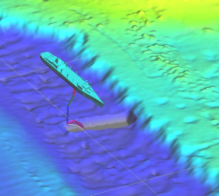
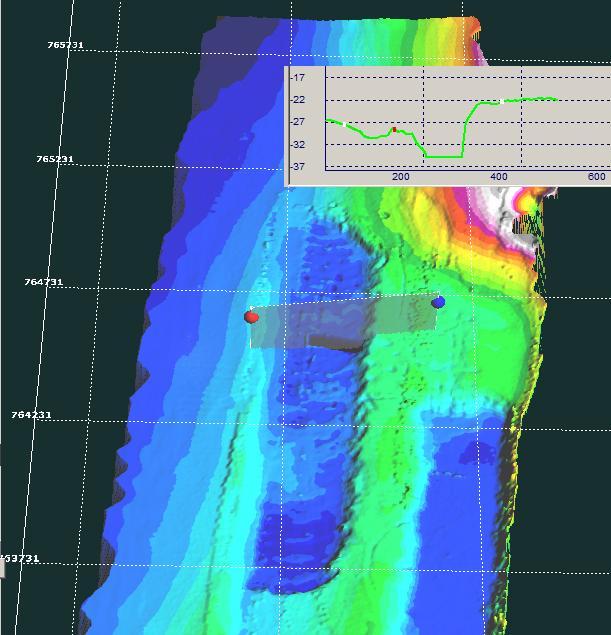
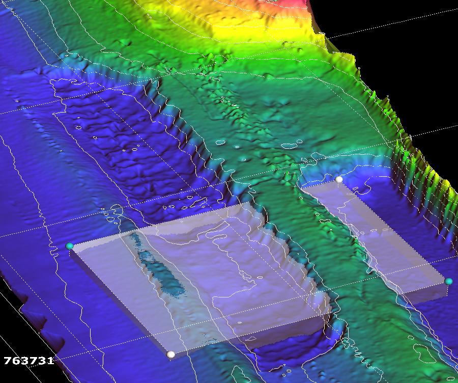
1 ScienceGL 3D DredgePRO. 3D DredgePRO is a software package specifically developed to provide analytical and 3D visualization capabilities through various stages of dredging projects. In general, dredging is a resource intensive, complex, and expensive process that requires sophisticated heavy machinery and equipment. The process, at a high level, consists of: (i) data collection, such as hydrographic survey and/or sonar scanning, (ii) project planning and targeted shape design of the output underwater soil with cut-remove volume estimation, and (iii) Precise control of the physical dredging process i.e. dredge arm positioning while providing displaced soil volume measurement and estimation in real time. Even a relatively straightforward first step (i) in a dredging project involves processing of very large amounts of survey data that requires a high-performance advanced multi-dimensional analytical and visualization solution. ScienceGL has invested in developing a set of advanced methods, algorithms and integrated software tools to significantly streamline and modernize entire dredging process while provide significant cost savings and improving accuracy. These R&D efforts resulted in an innovative dredging analysis and 3D visualization package that performs in most realistic 3D mode in real time. Some of the main differentiating features of 3D DredgePRO include: 3D DredgePRO permits multiple layers analysis and visualization during the initial dredging phase e.g. soils, sands, rock formations, etc. Various forms of planned design input such as DTM, DXF, and satellite navigation maps can be imported and visualized within the 3D scene. The user might use several hypothetical designs with qualitative and quantitative crosscomparison between them. ScienceGL s solution provides detailed cut estimation between all layers with volume calculation for all of area, or selected regions and volumes of interest (ROI, VOI). Please see the screenshots of the actual visualizations at the end of the document. We added multiple 3D dredging vessel models, each with multiple cutter suction tubes/excavators to provide users with dredging job overall control. Each cutter head can be controlled in regards to position, shape and size which allows for volume calculation comparable in accuracy to a physical method. The advanced 3D visualization capabilities of 3D DredgePRO were specifically designed for network of operators with multiple displays, each of them independent in their choice of 3D orientation angles and multiple intersection plots.
2 ScienceGL also developed highly optimized algorithms for processing of dredger-ground interaction model that simulates effect of dredging on soil. Using streaming GPS data from vessels and our approach described above the user can obtain real-time volume calculations, while dredging is physically being performed. Advanced volume calculation can take in account spillage effects. Detailed list of major features: Support for 3D DTM Matrix, sonar data, and random XYZ point data input formats Additional 2D layers: map charts, satellite images, etc. Advanced 3D models and visualization for both dredge vessels and underwater terrain Flexible zoom, pan, angles of view, stereo display support Multiple dredgers with multiple cutter suction tube sections Multiple 3D objects such as navigation marks, buoys, lighthouses, etc. Multiple CAD/CAM design models: DXF, DTM, custom standards 3D line contour and 3D line layers with excavation plan available to operator as separate layers Smoothed 3D surface view Multiple interactive 3D measurement tools: XYZ read out, intersection planes, volume, pin markers, area selectors, etc. Export: Flexible grid matrix output with various (including custom) formats export Real time Volume calculation with a possible account of spillage Real time new surface reconstruction ScienceGL, Inc. Tel: (401) info@sciencegl.com 140 North Main St. suite 2A, Attleboro, MA Fax:(508) USA
3

4
5
6
7

8
HYPACK HYPACK SURVEY DESIGN: HYPACK SURVEY: HYPACK EDITING: FINAL PRODUCTS: HYPACK HYPACK
 HYPACK HYPACK is one of the most widely used hydrographic surveying packages in the world, with over 3,000 users. It provides the surveyor with all of the tools needed to design their survey, collect data,
Forensic Image Comparator3D Tutor 3. Fingerprint images comparison. Latent Fingerprint Examination.
 Forensic Image Comparator3D Tutor 3. Fingerprint images comparison. Latent Fingerprint Examination. Introduction. In general, 3D image enhancement is an easy procedure, but it requires some understanding
3GSM GmbH. Plüddemanngasse 77 A-8010 Graz, Austria Tel Fax:
 White Paper Graz, April 2014 3GSM GmbH Plüddemanngasse 77 A-8010 Graz, Austria Tel. +43-316-464744 Fax: +43-316-464744-11 office@3gsm.at www.3gsm.at Measurement and assessment of rock and terrain surfaces
DIGITAL TERRAIN MODELS
 DIGITAL TERRAIN MODELS 1 Digital Terrain Models Dr. Mohsen Mostafa Hassan Badawy Remote Sensing Center GENERAL: A Digital Terrain Models (DTM) is defined as the digital representation of the spatial distribution
Teledyne PDS. Trailing Suction Hopper. Version April Teledyne RESON B.V. Stuttgartstraat AS Rotterdam The Netherlands
 Trailing Suction Hopper Teledyne PDS Version 1.1.0 April 2017 Teledyne RESON B.V. Stuttgartstraat 42-44 3047 AS Rotterdam The Netherlands Tel.: +31 (0)10 245 15 00 www.teledyne-reson.com Teledyne RESON
Teledyne PDS PDSPDSApplications
 Revision: 3 Januari 2014 I Applications January 2015 Contents 1. Overview of the packages... 3 1.1 Single Beam 3 1.2 Multibeam 4 1.3 Dredge 5 1.4 Other Applications 6 Page 2 of 6 Applications January 2015
Eye4Software Hydromagic Dredging Installing on a single ladder cutter dredger
 Eye4Software Hydromagic Dredging Installing on a single ladder cutter dredger INTRODUCTION Since version 7.0 of Eye4Software Hydromagic, it is possible to monitor the dredging depth and position of your
Engineering Geology. Engineering Geology is backbone of civil engineering. Topographic Maps. Eng. Iqbal Marie
 Engineering Geology Engineering Geology is backbone of civil engineering Topographic Maps Eng. Iqbal Marie Maps: are a two dimensional representation, of an area or region. There are many types of maps,
A Total Hydrographic Solution!
 A Total Hydrographic Solution! QINSy A Total Hydrographic Solution! QINSy 7 provides a user-friendly turnkey solution for all types of marine navigation, positioning and surveying activities. From survey
Proceedings of Western Dredging Association and Texas A&M University Center for Dredging Studies' "Dredging Summit and Expo 2015"
 Proceedings of Western Dredging Association and Texas A&M University Center for Dredging Studies' DYNAMIC UNDERWATER 3D SURVEY AND MONITORING DURING RECENT PLATFORM DREDGING OPERATION: REDUCING RISK AND
Teledyne PDS. Cutter Dredge. Version March Teledyne RESON B.V. Stuttgartstraat AS Rotterdam The Netherlands
 Cutter Dredge Teledyne PDS Version 2.1.1 March 2017 Teledyne RESON B.V. Stuttgartstraat 42-44 3047 AS Rotterdam The Netherlands Tel.: +31 (0)10 245 15 00 www.teledyne-reson.com Teledyne RESON has made
Trimble Dredge Navigation and Management Solutions
 Trimble Dredge Navigation and Management Solutions November 2018 Trimble Dredge Navigation and Management Solutions UPG (Ultimate Positioning Group) and SITECH Construction Systems are Australia s premier
QINSy. A Total Hydrographic Solution!
 QINSy A Total Hydrographic Solution! QINSy provides a user-friendly, turnkey solution for all types of marine navigation, positioning and surveying activities. From survey planning, to data collection,
Slope Stability of Open Pit Mine in 2D & 3D
 Slope Stability of Open Pit Mine in D & D MIDASoft Inc. Angel Francisco Martinez Civil Engineer Email : a.martinez@midasit.com Integrated Solver Optimized for the next generation64-bit platform Finite
8. Dredgepack. I. Overview. II. Running DREDGEPACK
 8. Dredgepack I. Overview DREDGEPACK enables you to monitor and track digging operations for hopper, cutter, and other dredge types. DREDGEPACK monitors the position and depth of the cutting tool on the
3DReshaper Help DReshaper Beginner's Guide. Surveying
 3DReshaper Beginner's Guide Surveying 1 of 29 Cross sections Exercise: Tunnel analysis Surface analysis Exercise: Complete analysis of a concrete floor Surveying extraction Exercise: Automatic extraction
Materialise Magics 23. What s new
 Materialise Magics 23 What s new Index UX/UI Improvements View cube and general toolbar Settings Performance improvements Magics RP Fillet Cut or punch: lap joint cut Boolean Honeycomb structures Tools
Introducing Settle 3D...
 Introducing Settle 3D... Rocscience will soon be releasing Settle 3D, a totally new software package for analysis of consolidation and settlement under foundations, embankments and surface excavations.
Terrain Modeling and Mapping for Telecom Network Installation Using Scanning Technology. Maziana Muhamad
 Terrain Modeling and Mapping for Telecom Network Installation Using Scanning Technology Maziana Muhamad Summarising LiDAR (Airborne Laser Scanning) LiDAR is a reliable survey technique, capable of: acquiring
NaviModel 3 Contours. (NaviModel 3.1 Rev 102 and above) Author : Jesper Knudsen Company : Eiva A/S Date:
 Author : Jesper Knudsen Company : Eiva A/S Date:") NaviModel 3 Contours (NaviModel 3.1 Rev 102 and above) Author : Jesper Knudsen Company : Eiva A/S Date: 2009-09-04 NaviModel Contours Tutorial Page 2 Introduction This tutorial takes you through steps
NaviModel 3 Contours (NaviModel 3.1 Rev 102 and above) Author : Jesper Knudsen Company : Eiva A/S Date: 2009-09-04 NaviModel Contours Tutorial Page 2 Introduction This tutorial takes you through steps
Integrating the Generations, FIG Working Week 2008,Stockholm, Sweden June 2008
 H. Murat Yilmaz, Aksaray University,Turkey Omer Mutluoglu, Selçuk University, Turkey Murat Yakar, Selçuk University,Turkey Cutting and filling volume calculation are important issues in many engineering
OPERATION MANUAL FOR DTM & ORTHOPHOTO
 BANGLADESH DIGITAL MAPPING ASSISTANCE PROJECT (BDMAP) OPERATION MANUAL FOR DTM & ORTHOPHOTO AUGUST 2011 VERSION 1 Introduction 1. General This Operation Manual is prepared by officers of Survey of Bangladesh
Computer Aided Design and Manufacture
 Computer Aided Design and Manufacture There are two types of computer aided design software, two dimensional and three dimensional modellers. Both can be used in manufacturing to drive computer aided machinery,
Delph. Seabed Mapping Software Suite FEATURES ABOUT DELPH SOFTWARE SUITE BENEFITS APPLICATIONS
 Delph Seabed Mapping Software Suite Delph Seismic, Delph Sonar and Delph Mag are complete software packages with dedicated acquisition, processing and interpretation components. They operate with any sidescan
Setting up Hydromagic:
 To operate Eye4Software Hydromagic and RosePoint ECS software packages simultaneously, the CEESCOPE echo sounder must be connected to the acquisition PC using the Ethernet (LAN) cable. The two software
Technical English -I 5 th week SURVEYING AND MAPPING
 Technical English -I 5 th week SURVEYING AND MAPPING What is surveying? It is the art of defining the positions of natural and man-made made features on the Earth s surface. Basic Tasks and Features in
Surpac Google Earth Tools
 Surpac Google Earth Tools Google Earth is a free software program that lets you fly anywhere on Earth to view satellite imagery, maps, terrain and 3D buildings. When used in conjunction with SURPAC, it
General GPS TPS ROB X POLE VOL RDN RPL Jobs management System settings (units, precision, parameters, etc.)
") XPAD Survey Modules XPAD Survey GPS TPS XPOLE General GPS TPS ROB XPOLE VOL RDN RPL Jobs management System settings (units, precision, parameters, etc.) Instruments GPS GPS TPS ROB XPOLE VOL RDN RPL Instrument
XPAD Survey Modules XPAD Survey GPS TPS XPOLE General GPS TPS ROB XPOLE VOL RDN RPL Jobs management System settings (units, precision, parameters, etc.) Instruments GPS GPS TPS ROB XPOLE VOL RDN RPL Instrument
INTRODUCTION TO MEDICAL IMAGING- 3D LOCALIZATION LAB MANUAL 1. Modifications for P551 Fall 2013 Medical Physics Laboratory
 INTRODUCTION TO MEDICAL IMAGING- 3D LOCALIZATION LAB MANUAL 1 Modifications for P551 Fall 2013 Medical Physics Laboratory Introduction Following the introductory lab 0, this lab exercise the student through
FEA/BEA interface for SCN AN 55
 Application Note to the KLIPPEL R&D SYSTEM The FEA/BEA interface is a text file based data interface providing various import and export features. Geometry and vibration data of a scanned speaker can be
Geometric Accuracy Evaluation, DEM Generation and Validation for SPOT-5 Level 1B Stereo Scene
 Geometric Accuracy Evaluation, DEM Generation and Validation for SPOT-5 Level 1B Stereo Scene Buyuksalih, G.*, Oruc, M.*, Topan, H.*,.*, Jacobsen, K.** * Karaelmas University Zonguldak, Turkey **University
APPLANIX PRODUCTS AND SOLUTIONS FOR MOBILE MAPPING AND POSITIONING CAPTURE EVERYTHING. POSPac MMS HYDRO 08 November 2008
 APPLANIX CAPTURE EVERYTHING POSPac MMS HYDRO 08 November 2008 Accurate Post Processed Position & Orientation For Modern Port Survey Operations. Increasing use of sonar & laser survey equipment with sub-centimetre
GTS NX INTERFACES AUTOCAD MIDAS GEN FOR TUNNEL SOIL PILE INTERACTION ANALYSIS
 INTERFACES AUTOCAD MIDAS GEN FOR TUNNEL SOIL PILE INTERACTION ANALYSIS Angel F. Martinez Civil Engineer MIDASOFT Integrated Solver Optimized for the next generation 64-bit platform Finite Element Solutions
Topocad portfolio. Adtollo adtollo.se/en
 Topocad portfolio Adtollo adtollo.se/en + 46 8 410 415 00 info@adtollo.se order@adtollo.se What is Topocad? Topocad is easy to use and provides a powerful CAD system for all requirements when it comes
Question: What are the origins of the forces of magnetism (how are they produced/ generated)?
?") This is an additional material to the one in the internet and may help you to develop interest with the method. You should try to integrate some of the discussions here while you are trying to answer the
This is an additional material to the one in the internet and may help you to develop interest with the method. You should try to integrate some of the discussions here while you are trying to answer the
Quick Start: GeoDAS-LT with Single Beam Echo Sounder
 Quick Start: GeoDAS-LT with Single Beam Echo Sounder I. Setting up GeoDAS-LT for Single Beam Echo Sounder Survey 1. Connect your single beam echo sounder, GPS receiver and other sensors (e.g. gyro and
A 3D Scanner Based Technology for Land Levelling
 A 3D Scanner Based Technology for Land Levelling Kunal Chakraborti, Rupam Ghosh Student, Dept of Civil Engineering, Modern Institute of Engineering & Technology, Bandel, Hooghly, West Bengal, India ABSTRACT:
3DReshaper Help 2017 MR1. 3DReshaper Beginner's Guide. Tank
 3DReshaper Beginner's Guide Tank 1 of 20 1 Introduction The Tank module is dedicated to tank analysis. It is aimed to above ground tanks, with vertical cylinder design, single shell, with or without roof.
L1 - Introduction. Contents. Introduction of CAD/CAM system Components of CAD/CAM systems Basic concepts of graphics programming
 L1 - Introduction Contents Introduction of CAD/CAM system Components of CAD/CAM systems Basic concepts of graphics programming 1 Definitions Computer-Aided Design (CAD) The technology concerned with the
2/19/2018. Who are we? Who am I? What is Scanning? How does scanning work? How does scanning work? Scanning for Today s Surveyors
 2/19/2018 Who are we? Scanning for Today s Surveyors Survey, GIS, and Construction dealer Founded in 1988 Employee Owned Headquartered in Bismarck, ND States covered: ND, SD, MN, MT, WY, CO, UT, ID, WA,
Extract. Revolutionary Motion Analysis Software. Flexibility
 Extract ProAnalyst provides motion analysis tools that can be applied to any video or image sequence, regardless of content or acquisition method. With ProAnalyst, any digital video camera becomes a measurement
Surveying Prof. Bharat Lohani Indian Institute of Technology, Kanpur. Lecture - 1 Module - 6 Triangulation and Trilateration
 Surveying Prof. Bharat Lohani Indian Institute of Technology, Kanpur Lecture - 1 Module - 6 Triangulation and Trilateration (Refer Slide Time: 00:21) Welcome to this another lecture on basic surveying.
EPIPOLAR IMAGES FOR CLOSE RANGE APPLICATIONS
 EPIPOLAR IMAGES FOR CLOSE RANGE APPLICATIONS Vassilios TSIOUKAS, Efstratios STYLIANIDIS, Petros PATIAS The Aristotle University of Thessaloniki, Department of Cadastre Photogrammetry and Cartography Univ.
Development of Equipment Performance Visualization Techniques Based on Distinct Element Method (DEM)
") Technical Paper Development of Equipment Performance Visualization Techniques Based on Distinct Element Method (DEM) Shinichi Mutou Toshihide Shibuya With dump trucks for mining and other applications
Technical Paper Development of Equipment Performance Visualization Techniques Based on Distinct Element Method (DEM) Shinichi Mutou Toshihide Shibuya With dump trucks for mining and other applications
Reset Cursor Tool Clicking on the Reset Cursor tool will clear all map and tool selections and allow tooltips to be displayed.
 SMS Featured Icons: Mapping Toolbar This document includes a brief description of some of the most commonly used tools in the SMS Desktop Software map window toolbar as well as shows you the toolbar shortcuts
Prepared for: CALIFORNIA COAST COMMISSION c/o Dr. Stephen Schroeter 45 Fremont Street, Suite 2000 San Francisco, CA
 REVIEW OF MULTIBEAM SONAR SURVEYS WHEELER REEF NORTH, SAN CLEMENTE, CALIFORNIA TO EVALUATE ACCURACY AND PRECISION OF REEF FOOTPRINT DETERMINATIONS AND CHANGES BETWEEN 2008 AND 2009 SURVEYS Prepared for:
HCImage. Image Acquisition and Analysis Software. Light... Camera... Acquisition...
 HCImage Image Acquisition and Analysis Software Light... Camera... Acquisition... HCImage Analysis HCImage Analysis provides comprehensive control of Hamamatsu cameras, microscopes, stages and other peripheral
This document will cover some of the key features available only in SMS Advanced, including:
 Key Differences between SMS Basic and SMS Advanced SMS Advanced includes all of the same functionality as the SMS Basic Software as well as adding numerous tools that provide management solutions for multiple
START>PROGRAMS>ARCGIS>
 Department of Urban Studies and Planning Spring 2006 Department of Architecture Site and Urban Systems Planning 11.304J / 4.255J GIS EXERCISE 2 Objectives: To generate the following maps using ArcGIS Software:
AUTOMATIC RECTIFICATION OF SIDE-SCAN SONAR IMAGES
 Proceedings of the International Conference Underwater Acoustic Measurements: Technologies &Results Heraklion, Crete, Greece, 28 th June 1 st July 2005 AUTOMATIC RECTIFICATION OF SIDE-SCAN SONAR IMAGES
Extract, Analyze, and Report Motion from Video
 Extract, Analyze, and Report Motion from Video Extract ProAnalyst provides motion analysis tools that can be applied to any video or image sequence, regardless of content or acquisition method. With ProAnalyst,
Title: Improving Your InRoads DTM. Mats Dahlberg Consultant Civil
 Title: Improving Your InRoads DTM Mats Dahlberg Consultant Civil Improving Your InRoads Digital Terrain Model (DTM) Digital Terrain Model A digital representation of a surface topography or terrain composed
VIY 3. Series Ground Penetrating Radars
 VIY 3 Series Ground Penetrating Radars Transient Technologies LLC is a leading Ukrainian developer and manufacturer of Ground Penetrating Radar (GPR) equipment. Company s engineers have been leading the
Advancements in Area-Based Imagery Processing
 Advancements in Area-Based Imagery Processing An integrated Geocoder delivers a streamlined workflow and new capabilities Alexander MacDonald, CARIS, Canada Corey Collins, CARIS, Canada For many years
Rethinking Road Planning and Design Workflows:
 Rethinking Road Planning and Design Workflows: Unlocking the Potential of LiDAR Craig Speirs Softree Technical Systems Forest road construction is one of the most expensive components of timber harvesting.
Diamond Engineer: Tunnel Series Training 2
 Diamond Engineer: Tunnel Series Training 2 Angel Francisco Martinez Application Engineer MIDAS NY Content 01 Introduction 02 Construction Stages 03 Demo 04 Post - Processing Introduction About MIDAS No.
3D Terrain Modelling of the Amyntaio Ptolemais Basin
 2nd International Workshop in Geoenvironment and 1 3D Terrain Modelling of the Amyntaio Ptolemais Basin G. Argyris, I. Kapageridis and A. Triantafyllou Department of Geotechnology and Environmental Engineering,
Integrated Metrology Suite for Effort Free Measurement. AxelSystems AXEL 7.
 AxelSystems Integrated Metrology Suite for Effort Free Measurement AXEL 7 www.axelsystems.com ADVANCED FEATURES MAKE AXEL EASY TO USE Work smarter and faster with intuitive graphic interface. Our already
Files Used in this Tutorial
 Generate Point Clouds and DSM Tutorial This tutorial shows how to generate point clouds and a digital surface model (DSM) from IKONOS satellite stereo imagery. You will view the resulting point clouds
MIKE Zero. Project Oriented Water Modelling. Step-by-step training guide
 MIKE Zero Project Oriented Water Modelling Step-by-step training guide MIKE 2017 DHI headquarters Agern Allé 5 DK-2970 Hørsholm Denmark +45 4516 9200 Telephone +45 4516 9333 Support +45 4516 9292 Telefax
Study on Levelling Works Made for Drawing Tridimensional Models of Surface and Calculus of the Volume of Earthwork
 Available online at www.sciencedirect.com ScienceDirect Agriculture and Agricultural Science Procedia 6 ( 2015 ) 413 420 ST26733, International Conference "Agriculture for Life, Life for Agriculture" Study
ESTONIAN HYDROGRAPHIC INFORMATION SYSTEM (HIS) By Peeter VÄLING (Head of Hydrographic Department - Estonian Maritime Administration) Abstract.
 By Peeter VÄLING (Head of Hydrographic Department - Estonian Maritime Administration) Abstract.") ESTONIAN HYDROGRAPHIC INFORMATION SYSTEM (HIS) By Peeter VÄLING (Head of Hydrographic Department - Estonian Maritime Administration) Abstract This paper provides a brief description of the Estonian Hydrographic
ESTONIAN HYDROGRAPHIC INFORMATION SYSTEM (HIS) By Peeter VÄLING (Head of Hydrographic Department - Estonian Maritime Administration) Abstract This paper provides a brief description of the Estonian Hydrographic
WSP NAVIGATOR. V1.6 IssueDate: V1.1 P/N: WSP Version: Version:
 Doc. Doc.P/N: P/N: WSP-009-005 WSP-009-003 Version: V1.1 Version: V1.6 Issue 20122015 IssueDate: Date: June January NAVIGATOR Document Revision History Revision Date Reason for Change Version 4 Feb 2010
Oasys Pdisp. Copyright Oasys 2013
 Oasys Pdisp Copyright Oasys 2013 All rights reserved. No parts of this work may be reproduced in any form or by any means - graphic, electronic, or mechanical, including photocopying, recording, taping,
COMPONENTS. The web interface includes user administration tools, which allow companies to efficiently distribute data to internal or external users.
 COMPONENTS LASERDATA LIS is a software suite for LiDAR data (TLS / MLS / ALS) management and analysis. The software is built on top of a GIS and supports both point and raster data. The following software
LASERDATA LIS build your own bundle! LIS Pro 3D LIS 3.0 NEW! BETA AVAILABLE! LIS Road Modeller. LIS Orientation. LIS Geology.
 LIS 3.0...build your own bundle! NEW! LIS Geology LIS Terrain Analysis LIS Forestry LIS Orientation BETA AVAILABLE! LIS Road Modeller LIS Editor LIS City Modeller colors visualization I / O tools arithmetic
Mapping Project Report Table of Contents
 LiDAR Estimation of Forest Leaf Structure, Terrain, and Hydrophysiology Airborne Mapping Project Report Principal Investigator: Katherine Windfeldt University of Minnesota-Twin cities 115 Green Hall 1530
Slope Stability Problem Session
 Slope Stability Problem Session Stability Analysis of a Proposed Soil Slope Using Slide 5.0 Tuesday, February 28, 2006 10:00 am - 12:00 pm GeoCongress 2006 Atlanta, GA software tools for rock and soil
DTM Mapping Addition of Customisable Toolbars
 Well another year has passed here at the office and another version of the NRG Survey System for Windows is being released. Version 7 will be available from September 2003 onwards. We feel that the User
ABSTRACT 1. INTRODUCTION
 Published in SPIE Proceedings, Vol.3084, 1997, p 336-343 Computer 3-d site model generation based on aerial images Sergei Y. Zheltov, Yuri B. Blokhinov, Alexander A. Stepanov, Sergei V. Skryabin, Alexander
IMARIS 3D and 4D interactive analysis and visualization solutions for the life sciences
 IMARIS 3D and 4D interactive analysis and visualization solutions for the life sciences IMARIS A Brief History For over 20 years Bitplane has offered enabling scientific software tools for the life science
Leica FlexField plus & Leica FlexOffice A Perfect Match
 Leica FlexField & Leica FlexOffice A Perfect Match FlexField Onboard Software General File Management Data Import Data Export Status icon bar Instrument Protection with PIN Stake Out beep Map Select Programs
This document contains a list of all changes, new features, bug fixed introduced in this last version of X PAD Survey.
 News X PAD Survey - January 2014 X PAD Survey 2.5.5 This document contains a list of all changes, new features, bug fixed introduced in this last version of X PAD Survey. GPS X-Y RSM: X and Y RMS accuracy
MATLAB 7. The Language of Technical Computing KEY FEATURES
 MATLAB 7 The Language of Technical Computing MATLAB is a high-level technical computing language and interactive environment for algorithm development, data visualization, data analysis, and numerical
DOWN PLUNGE CROSS SECTIONS
 GG303 Lab 7 10/6/10 1 DOWN PLUNGE CROSS SECTIONS I Main Topics A Cylindrical folds B Downplunge cross-section views C Apparent dip II Cylindrical folds A Surface of a cylindrical fold is parallel to a
Features and Benefits
 CAiCE Visual Survey 10 Features and Benefits CAiCE Visual Survey 10 software enables surveying professionals to import, process, analyze, and present surveying all in one software package. Visual Survey
Chapter 2 Surfer Tutorial
 Chapter 2 Surfer Tutorial Overview This tutorial introduces you to some of Surfer s features and shows you the steps to take to produce maps. In addition, the tutorial will help previous Surfer users learn
BUILDING DETECTION AND STRUCTURE LINE EXTRACTION FROM AIRBORNE LIDAR DATA
 BUILDING DETECTION AND STRUCTURE LINE EXTRACTION FROM AIRBORNE LIDAR DATA C. K. Wang a,, P.H. Hsu a, * a Dept. of Geomatics, National Cheng Kung University, No.1, University Road, Tainan 701, Taiwan. China-
Quick Scope. CNC/Manually-operated Vision Measuring Microscope
 Bulletin No. 1579 Quick Scope CNC/Manually-operated Vision Measuring Microscope Quick Scope Non-contact Vision Measuring Microscopes Offer High Accuracy, Excellent Affordability and Powerful Capabilities!
COORDINATE TRANSFORMATION. Lecture 6
 COORDINATE TRANSFORMATION Lecture 6 SGU 1053 SURVEY COMPUTATION 1 Introduction Geomatic professional are mostly confronted in their work with transformations from one two/three-dimensional coordinate system
NEi FEA. IRONCAD Advanced FEA. IRONCAD Advanced FEA. NEi FEA
 2011 Overview has been designed as a universal, adaptive and user-friendly graphical user interface for geometrical modeling, data input and visualization of results for all types of numerical simulation
Getting Started. What is SAS/SPECTRAVIEW Software? CHAPTER 1
 3 CHAPTER 1 Getting Started What is SAS/SPECTRAVIEW Software? 3 Using SAS/SPECTRAVIEW Software 5 Data Set Requirements 5 How the Software Displays Data 6 Spatial Data 6 Non-Spatial Data 7 Summary of Software
A NEW STRATEGY FOR DSM GENERATION FROM HIGH RESOLUTION STEREO SATELLITE IMAGES BASED ON CONTROL NETWORK INTEREST POINT MATCHING
 A NEW STRATEGY FOR DSM GENERATION FROM HIGH RESOLUTION STEREO SATELLITE IMAGES BASED ON CONTROL NETWORK INTEREST POINT MATCHING Z. Xiong a, Y. Zhang a a Department of Geodesy & Geomatics Engineering, University
Intelligent photogrammetry. Agisoft
 Intelligent photogrammetry Agisoft Agisoft Metashape is a cutting edge software solution, with its engine core driving photogrammetry to its ultimate limits, while the whole system is designed to deliver
QUARTZ PCI. SLOW-SCAN for ANALOG SEMs THE MEASURING, ANNOTATING, PROCESSING, REPORTING, ARCHIVING, DO EVERYTHING SOLUTION FOR MICROSCOPY
 QUARTZ PCI SLOW-SCAN for ANALOG SEMs THE MEASURING, ANNOTATING, PROCESSING, REPORTING, ARCHIVING, DO EVERYTHING SOLUTION FOR MICROSCOPY ADDING THE LATEST DIGITAL IMAGING CAPABILITIES TO YOUR SEM IMPROVES
PLOTTING DEPTH CONTOURS BASED ON GRID DATA IN IRREGULAR PLOTTING AREAS
 PLOTTING DEPTH CONTOURS BASED ON GRID DATA IN IRREGULAR PLOTTING AREAS Zhang, L., Li, S. and Li, Y. Department of Hydrography and Cartography,Dalian Naval Academy, 667, Jiefang Road, Dalian, Liaoning,
CONSIDERATIONS IN BUILDING AND USING DREDGE SIMULATORS
 CONSIDERATIONS IN BUILDING AND USING DREDGE SIMULATORS S.A. Miedema ABSTRACT. INTRODUCTION. THE EDUCATIONAL SIMULATOR. THE TRAINING SIMULATOR. THE PREDICTION SIMULATOR. THE PREPARATION SIMULATOR. THE RESEARCH
Sirovision TM Release 6.0 Release Notes
 2014-2015 Sirovision TM Release 6.0 Release Notes. Contents 2014-2015 Whats new in Sirovision 6?... 1 New GUI Design... 1 The new Explorer Window... 2 New Icons... 3 Performance Improvements... 5 Reduction
The Results of Limiting MRU Updates In Multibeam Data by Pat Sanders, HYPACK, Inc.
 The Results of Limiting MRU Updates In Multibeam Data by Pat Sanders, HYPACK, Inc. Abstract: Some Motion Reference Units (MRUs) can deliver heave- pitch- roll data at rates up to 100Hz. This paper investigates
Transactions on Information and Communications Technologies vol 16, 1996 WIT Press, ISSN
 ransactions on Information and Communications echnologies vol 6, 996 WI Press, www.witpress.com, ISSN 743-357 Obstacle detection using stereo without correspondence L. X. Zhou & W. K. Gu Institute of Information
Jeffrey A. Schepers P.S. EIT Geospatial Services Holland Engineering Inc. 220 Hoover Blvd, Suite 2, Holland, MI Desk
 Jeffrey A. Schepers P.S. EIT Geospatial Services Holland Engineering Inc. 220 Hoover Blvd, Suite 2, Holland, MI 49423 616-594-5127 Desk 616-322-1724 Cell 616-392-5938 Office Mobile LiDAR - Laser Scanning
A step by step introduction to TopoFlight
 November 20, 2014 TopoFlight_First_Steps.docx 2004057./KB/04 A step by step introduction to TopoFlight Content 1 Introduction...2 2 Creating the area of interest with GoogleEarth...2 3 Creating the TopoFlight
Images from 3D Creative Magazine. 3D Modelling Systems
 Images from 3D Creative Magazine 3D Modelling Systems Contents Reference & Accuracy 3D Primitives Transforms Move (Translate) Rotate Scale Mirror Align 3D Booleans Deforms Bend Taper Skew Twist Squash
Training Course Content
 Pioneering engineering software systems, support & services. Training Course Content 29800 Middlebelt Road Suite 100 Farmington Hills, MI 48334 United States of America Tel: +1 248 737 9760 Fax: +1 248
Programming of Complex machine tools (Mill-Turn) in NX CAM Dr. Tom van t Erve, Director Development - NX CAM
 in NX CAM Dr. Tom van t Erve, Director Development - NX CAM") Programming of Complex machine tools (Mill-Turn) in NX CAM Dr. Tom van t Erve, Director Development - NX CAM Restricted Siemens AG 2017 Realize innovation. Mill-Turn / Multi-Function programming with NX
Programming of Complex machine tools (Mill-Turn) in NX CAM Dr. Tom van t Erve, Director Development - NX CAM Restricted Siemens AG 2017 Realize innovation. Mill-Turn / Multi-Function programming with NX
Solid design. Reliable pipelines. Simulation results can be viewed and printed in different formats in tables, graphs and in 3D illustrations.
 Bringing added value to pipeline engineers worldwide SAGE Profile has been specifically designed to assist pipeline engineers in the design, installation and analysis of offshore pipelines. The powerful
3D Measurement and Control, Made Easy
 3D Measurement and Control, Made Easy WHAT WE DO LMI Technologies is a global leader in 3D scanning, visualization, measurement, and control technology. We focus on developing products to deliver a customer
QUARTZ PCI. SLOW-SCAN for ANALOG SEMs THE MEASURING, ANNOTATING, PROCESSING, REPORTING, ARCHIVING, DO EVERYTHING SOLUTION FOR MICROSCOPY
 QUARTZ PCI SLOW-SCAN for ANALOG SEMs THE MEASURING, ANNOTATING, PROCESSING, REPORTING, ARCHIVING, DO EVERYTHING SOLUTION FOR MICROSCOPY ADDING THE LATEST DIGITAL IMAGING CAPABILITIES TO YOUR SEM IMPROVES
A Practical Guide to Using QGIS
 A Practical Guide to Using QGIS 1.1 INTRODUCTION Quantum GIS (QGIS) is a useful mapping software that enables the compilation and displaying of spatial data in the form of a map. Gaining experience in
WMS 9.1 Tutorial GSSHA Modeling Basics Stream Flow Integrate stream flow with your GSSHA overland flow model
 v. 9.1 WMS 9.1 Tutorial Integrate stream flow with your GSSHA overland flow model Objectives Learn how to add hydraulic channel routing to your GSSHA model and how to define channel properties. Learn how