Operational use of numerical dispersion/fallout models at the USGS to advise partner agencies and the public of ashfall hazards
|
|
|
- Ashlee Hood
- 5 years ago
- Views:
Transcription
1 Operational use of numerical dispersion/fallout models at the USGS to advise partner agencies and the public of ashfall hazards Hans F. Schwaiger 1, Larry G. Mastin 2 1 Alaska Volcano Observatory, Anchorage, AK 2 Cascades Volcano Observatory, Vancouver, WA WMO 7 th International Volcanic Ash Workshop Anchorage, AK
2 Outline USGS use of dispersion models Communicating to agency partners Communicating to general public Challenges bringing a research tool into broad operational use

 29 seismically monitored")
3 Volcanism in the North Pacific Rim Volcanoes in AK 52 historically active Organized by threat level 5 Very High Threat (red) 26 High threat (orange) 31 Moderate threat (yellow) 29 seismically monitored
4 Dispersion models Trajectory Models Hysplit (NOAA) Used operationally by AVO since early 1990 s (internally) Publically available

5 Dispersion models Particle Models Puff (UAF-GI) Used operationally by AVO since late 1990 s (internally) Automatic runs posted publically via UAF/AVO webpages Interface to model is publically available

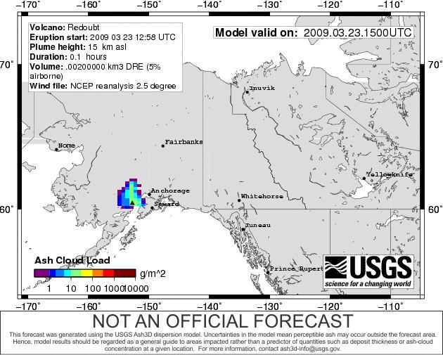
6 Fallout models Ashfall Used operationally at CVO for MSH in 2004 Used at AVO for Redoubt 2009 Used internally to inform staff for communicating hazard assessment


7 The Ash3d dispersion model Developed in 2010 Both a research tool and used in operations Calculates airborne ash concentration and deposit thickness Used during unrest to anticipate Used during eruptions to forecast Runs on linux systems Web-based interface Example grid Redoubt volcano Source nodes

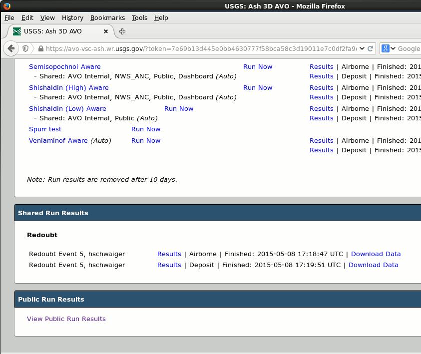
8 The Ash3d web interface Password-controlled site Public site 3 Servers AVO, CVO, Menlo Park


9 Ash3d output Animations Results that can be analyzed in Google Earth, ArcMap etc. Printable graphics Tables of arrival times etc.


10 Ash3d users ~175 users Used operationally at AVO and CVO Local and national government agencies International users volcano observatories Geological/Meteorological offices VDAP Individual researchers
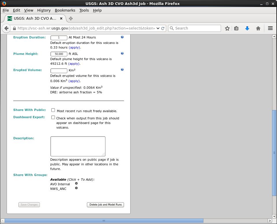
11 Operational: Simplified web interface To facilitate widespread use, we provide a simplified web interface with instructions and preset parameters
")
12 Research: full-featured web interface Select users can access advanced options for research investigations Most research investigations use Ash3d directly (i.e. not through the web interface)
13 Communicating results with partner agencies

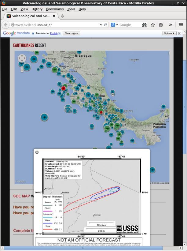
14 Results page (airborne)

15 Results page (deposit)

16 Full data bundles Airborne run zip file contain Individual graphics Input files Kmz files of additional variables Text files of affected airports documentation Deposit run zip file can be downloaded separately

17 Communicating results with public No log-in credentials are needed Full download bundles are available for airborne and deposit simulations

18 Communicating results with public: AVO homepage

19 Communicating results with public: AVO homepage
20 Communicating results with public: AVO homepage

21 Communicating results with public: AVO homepage

22 Communicating results with public: AVO homepage

23 Communicating results with public: AVO homepage
24 Customer needs/wants from dispersion models General Public In anticipation of an event Where might it go? In response to events Where is it going? When is it going to get here? How much? How long? Agency partners VAAC/AAWU/FAA Cloud top/bottom in FL Ash Fall Advisory NOAA Impact levels Local time zone Probabilistic/ensemble models International partners Metric units Custom locations on maps Limited internet
25 Challenges: disseminating model results to public Distinction between automated hypothetical runs forecasts based on most recent knowledge of ongoing eruption Mitigation efforts Activity page will prominently state if an eruption has begun Comments are included on all activity pages stating that models will be updated with current information when available Provide links to official products


26 Challenges: Educating users Usage of interface CSAV course Online training Interpretation of results and the limitations of the model Sources of errors Wind data Eruption Source Parameters Plume height Erupted mass Grainsize distribution Start time/duration


27 Challenges: Transferring research to operations Column models (umbrella cloud) Inverse methods Satellite data Ensembles/probabilistic maps Resuspension Non-linear processes (aggregation) Etna Eyja MSH wind Pinatubo Pinatubo
28 Conclusions AVO has a long history of internal use of dispersion models Communicating results with agency partners is more developed, more frequently reviewed Output graphics of automated runs are posted to the AVO webpage with links to more detailed output and supporting documentation Largest impediments to transferring research efforts to operations are Training end users Computational resources
HYSPLIT model description and operational set up for benchmark case study
 HYSPLIT model description and operational set up for benchmark case study Barbara Stunder and Roland Draxler NOAA Air Resources Laboratory Silver Spring, MD, USA Workshop on Ash Dispersal Forecast and
Unified Model Intercomparisons for Volcanic Ash Transport Modeling
 Unified Model Intercomparisons for Volcanic Ash Transport Modeling Don Morton 1, Dèlia Arnold 2, Peter Webley 3, Gerhard Wotawa 2, Barbara Stunder 4 1 Arctic Region Supercomputing Center, University of
Using Smoke Modeling Tools for Prescribed Fire Planning and Implementation A Quick Set of Instructions (Revised December 2017)
") Using Smoke Modeling Tools for Prescribed Fire Planning and Implementation A Quick Set of Instructions (Revised December 2017) Fire Management Officers (FMOs) in Region 8 are using smoke modeling more
Using Smoke Modeling Tools for Prescribed Fire Planning and Implementation A Quick Set of Instructions (Revised December 2017) Fire Management Officers (FMOs) in Region 8 are using smoke modeling more
Survey of Evolutionary and Probabilistic Approaches for Source Term Estimation!
 Survey of Evolutionary and Probabilistic Approaches for Source Term Estimation! Branko Kosović" " George Young, Kerrie J. Schmehl, Dustin Truesdell (PSU), Sue Ellen Haupt, Andrew Annunzio, Luna Rodriguez
Rob Jackson UTC Dayton, OH Neil Martin Dstl, UK MOD
 Environmental Particulate FOD - Data Integration in US and UK for Operational Decision Making Rob Jackson UTC Dayton, OH Neil Martin Dstl, UK MOD 1 Scope The current situation Where do we want to get to?
THE HAZARD NOTIFICATION SYSTEM (HANS) SETH FRANK SNEDIGAR. B.S., Montana Tech of the University of Montana, 2001
 SETH FRANK SNEDIGAR. B.S., Montana Tech of the University of Montana, 2001") THE HAZARD NOTIFICATION SYSTEM (HANS) BY SETH FRANK SNEDIGAR B.S., Montana Tech of the University of Montana, 2001 Submitted in partial fulfillment of the requirements for the degree of Master of Science
THE HAZARD NOTIFICATION SYSTEM (HANS) BY SETH FRANK SNEDIGAR B.S., Montana Tech of the University of Montana, 2001 Submitted in partial fulfillment of the requirements for the degree of Master of Science
Tianfeng Chai1,2,3, Ariel Stein2, and Fong Ngan1,2,3
 Tianfeng Chai1,2,3, Ariel Stein2, and Fong Ngan1,2,3 1: Cooperative Institute for Climate & Satellites Maryland, USA 2: NOAA, USA 3: University of Maryland, College, Park, MD, USA HYSPLIT model CAPTEX
EPOS a long term integration plan of research infrastructures for solid Earth Science in Europe
 EPOS a long term integration plan of research infrastructures for solid Earth Science in Europe Massimo Cocco EPOS PP Coordinator A Forward Look to a Roadmap for Solid Earth Science in Europe October 17
Making Data and Mapping Platforms More Relevant and Useful During Decision Support
 Making Data and Mapping Platforms More Relevant and Useful During Decision Support GeoCollaborate - Rafael de Ameller - rafael@stormcenter.com - (202) 494-3477 Abstract Geographic Information Systems (GIS)
Basic Backward Trajectory to GIS Instructions
 Introduction Basic Backward Trajectory to GIS Instructions NOAA s Hysplit Modeling software is available for use on the Internet. The software can be used to create forward plumes from a source, as well
Tsunami Readiness in Trinidad and Tobago. Presented By: Eric Mackie
 Tsunami Readiness in Trinidad and Tobago Presented By: Eric Mackie Outline Our Vulnerability Trinidad & Tobago Tsunami Readiness Current Initiatives Tsunami Early Warning Protocol Challenges Sustained
3D Elevation Program GeoCue Webinar April 29, The National Map
 + 3D Elevation Program GeoCue Webinar April 29, 2014 The National Map + 3D Elevation Program (3DEP) 2 Topics What is the 3DEP? Overview and background: National Elevation Dataset National Enhanced Elevation
Flash Flood Guidance System with Global Coverage
 Flash Flood Guidance System with Global Coverage Robert Jubach General Manager Hydrologic Research Center A Non-profit, Public Benefit Corporation http://www.hrc-lab.org Introduction Discuss a GLOBAL initiative
UV Remote Sensing of Volcanic Ash
 UV Remote Sensing of Volcanic Ash Kai Yang University of Maryland College Park WMO Inter-comparison of Satellite-based Volcanic Ash Retrieval Algorithms Workshop June 26 July 2, 2015, Madison, Wisconsin
The Alaska Marine Information System
 The Alaska Marine Information System Dr. Mark Johnson Professor of Marine Science Institute of Marine Science University of Alaska Fairbanks Google Alaska Ocean Observing System or AOOS See Access the
1 Introduction. 1.1 Clicking on any orange box shows the login window. Seatrack Web last updated
 Seatrack Web last updated 2016-11-07 1 Introduction Below follow simple screenshots of what to expect when selecting the orange boxes. This is the start page for Seatrack Web located at https://stw-helcom.fcoo.dk/.
NORTH/WEST PASSAGE. Operations and Travel Information Integration Sharing (OTIIS) Website Structure and Ownership. August 2016
 Website Structure and Ownership. August 2016") NORTH/WEST PASSAGE August 2016 Operations and Travel Information Integration Sharing (OTIIS) Website Structure and Ownership Final Summary Report: Project 10.1 Table of Contents 1.0 INTRODUCTION... 1 1.1
NORTH/WEST PASSAGE August 2016 Operations and Travel Information Integration Sharing (OTIIS) Website Structure and Ownership Final Summary Report: Project 10.1 Table of Contents 1.0 INTRODUCTION... 1 1.1
Dr. Theresa Modrick, Research Engineer Dr. Rochelle Graham, Research Meteorologist & Education Director Hydrologic Research Center
 Dr. Theresa Modrick, Research Engineer Dr. Rochelle Graham, Research Meteorologist & Education Director Hydrologic Research Center Central Asia Regional Flash Flood Guidance System Steering Committee Meeting
MASAS. Overview & Backgrounder Document. Consultation Package. CanOps
 CanOps Overview & Backgrounder Document Consultation Package Defining CanOpS Multi-Agency Situational Awareness System () is a national information aggregation system that facilitates sharing situational
SIGMET CASE STUDY & PROBLEMS. By AZLINAH EUSOFF National Aviation Meteorological Centre MET Malaysia
 SIGMET CASE STUDY & PROBLEMS By AZLINAH EUSOFF National Aviation Meteorological Centre MET Malaysia azlinah@met.gov.my NEIGHBOURING YANGON PHNOM PENH MANILA CHENNAI BANGKOK HO-CHI MINH SINGAPORE KUALA
Global Partnership on Space Technology Applications for Disaster Risk Reduction (GP-STAR)
") Committee on Earth Observation Satellites Global Partnership on Space Technology Applications for Disaster Risk Reduction (GP-STAR) Stéphane Chalifoux et al., CSA, Chair of CEOS WG on Disasters Expert
Committee on Earth Observation Satellites Global Partnership on Space Technology Applications for Disaster Risk Reduction (GP-STAR) Stéphane Chalifoux et al., CSA, Chair of CEOS WG on Disasters Expert
EarthCube and Cyberinfrastructure for the Earth Sciences: Lessons and Perspective from OpenTopography
 EarthCube and Cyberinfrastructure for the Earth Sciences: Lessons and Perspective from OpenTopography Christopher Crosby, San Diego Supercomputer Center J Ramon Arrowsmith, Arizona State University Chaitan
Member of the County or municipal emergency management organization
 EMERGENCY OPERATIONS PLAN SUUPPORT ANNEX B PRIVATE-SECTOR COORDINATION Coordinating Agency: Cooperating Agencies: Chatham Emergency Management Agency All Introduction Purpose This annex describes the policies,
Development and progress of the Oceania Regional Seismic Network (ORSNET) for Tsunami Early Warning
 for Tsunami Early Warning") Development and progress of the Oceania Regional Seismic Network (ORSNET) for Tsunami Early Warning Esline Garaebiti, Sylvain Todman, Pierre Lebellegard Vanuatu Meteorology & Geo-Hazards Department Ministry
Development and progress of the Oceania Regional Seismic Network (ORSNET) for Tsunami Early Warning Esline Garaebiti, Sylvain Todman, Pierre Lebellegard Vanuatu Meteorology & Geo-Hazards Department Ministry
Infrastructure Resilience in Northland. Northland Lifelines Group October 2008
 Infrastructure Resilience in Northland Northland Lifelines Group October 2008 NLG what have we achieved so far? Priority utility sites and routes Lifeline utility protocols and debriefs following events
DHS S&T supports National Level Exercise 2011 using SUMMIT
 Fall 2011 STANDARD UNIFIED MODELING & MAPPING INTEGRATION TOOLKIT DHS S&T supports National Level Exercise 2011 using SUMMIT SUMMIT provides next-generation exercise capabilities to NLE 11 The Department
The Office of Infrastructure Protection
 The Office of Infrastructure Protection National Protection and Programs Directorate Department of Homeland Security Protective Security Advisors and Special Event Domestic Incident Tracker Overview Federal
Potential elements for strengthened early warning incorporating ENSO signal: case of the Pacific SIDS
 Extraordinary Meeting of Presidents of Regional Associations and Presidents of Technical Commissions Mechanism for WMO contributions to the GFCS Potential elements for strengthened early warning incorporating
CIPP/G (Certified Information Privacy Professional US Government)
") CIPP/G (Certified Information Privacy Professional US Government) Course Description (image) The Certified Information Privacy Professional/Government (CIPP/G) is the first publicly available privacy certification
CIPP/G (Certified Information Privacy Professional US Government) Course Description (image) The Certified Information Privacy Professional/Government (CIPP/G) is the first publicly available privacy certification
How to use Water Data to Produce Knowledge: Data Sharing with the CUAHSI Water Data Center
 How to use Water Data to Produce Knowledge: Data Sharing with the CUAHSI Water Data Center Jon Pollak The Consortium of Universities for the Advancement of Hydrologic Science, Inc. (CUAHSI) August 20,
CompTIA CASP (Advanced Security Practitioner)
") CompTIA CASP (Advanced Security Practitioner) Course Length: 5 days (virtual) Click here to view the current class schedule! Overview: The CompTIA Advanced Security Practitioner (CASP) Certification is
CompTIA CASP (Advanced Security Practitioner) Course Length: 5 days (virtual) Click here to view the current class schedule! Overview: The CompTIA Advanced Security Practitioner (CASP) Certification is
Applying Mitigation. to Build Resilient Communities
 Applying Mitigation to Build Resilient Communities The Hazards Around Us Think about the natural hazard that... poses the greatest risk to where you live or work OR has had the greatest impact on you personally
SAR Organization in the NAM/CAR/SAM Regions 2.1 SAR drills. SARMAP Software System for SAR Planning, Coordination and Operations Control
 SAR/NAM/CAR/SAM IP/07 International Civil Aviation Organization 04/05/09 Search and Rescue (SAR) Meeting for the North American, Caribbean and South American Regions (SAR/NAM/CAR/SAM) (Puntarenas, Costa
Frequently Asked Questions
 ArcGIS Online Map This map will support Forest Stewards, partner organizations, and contractors in carrying out the mission of the Green Seattle Partnership (GSP). Maps help communicate about work areas
Global Partnership using Space Technology Applications for Disaster Risk Reduction
 Global Partnership using Space Technology Applications for Disaster Risk Reduction General overview: Version May 8th, 2017 GP-STAR launch During the WCDRR UNOOSA / UN SPIDER, GEO, CEOS and several international
Development of Methodology to Identify the Areas where Buildings are Broken down by Earthquake using Airborne Laser Technology
 Development of Methodology to Identify the Areas where Buildings are Broken down by Earthquake using Airborne Laser Technology by Hiromichi Maruyama 1, Masuo Taguchi 1, Masanori Sugiyama 1 and Yoshinori
DISASTER RISK REDUCTION AND MANAGEMENT USING ICT
 DISASTER RISK REDUCTION AND MANAGEMENT USING ICT Presented by: Paolo Jonas Alan Information and Communications Technology Division Office of Civil Defense Scope of Presentation I. THE PHILIPPINE DISASTER
Hazard Management Cayman Islands
 Hazard Management Cayman Islands Strategic Plan 2012 2016 Executive Summary HMCI strategic plan outlines the agency s outlook in the next five years and illustrates the main strategies as goals that will
J1.6 MONITORING AND ANALYZING THE GLOBAL OCEAN OBSERVING SYSTEM WITH THE OBSERVING SYSTEM MONITORING CENTER
 J1.6 MONITORING AND ANALYZING THE GLOBAL OCEAN OBSERVING SYSTEM WITH THE OBSERVING SYSTEM MONITORING CENTER Kevin M. O'Brien 1*,S. Hankin 2, R. Schweitzer 3, K. Kern 4, M. Little 4,T. Habermann 5, N. Auerbach
National Earthquake Risk Reduction Program in Haiti
 National Earthquake Risk Reduction Program in Haiti Goal: Build and maintain Haiti s capability to reduce earthquake risk by implementing an integrated and sustainable program in earthquake science, engineering,
Developing a Holistic Strategy To Achieve Community Health Resilience
 Developing a Holistic Strategy To Achieve Community Health Resilience Paula Scalingi, Director Pacific Northwest Center for Regional Disaster Resilience Pacific Northwest Border Health Alliance Seventh
Gradintelligence student support FAQs
 Gradintelligence student support FAQs Account activation issues... 2 I have not received my activation link / I cannot find it / it has expired. Please can you send me a new one?... 2 My account is showing
By Tracy J. Stark 1. Search and Discovery Article #40133 (2004) Introduction
 Introduction") GC Value in Visualization* By Tracy J. Stark 1 Search and Discovery Article #40133 (2004) *Adapted from the Geophysical Corner column in AAPG Explorer, June, 2004, entitled Why Do We Need to Have Visualization?
GC Value in Visualization* By Tracy J. Stark 1 Search and Discovery Article #40133 (2004) *Adapted from the Geophysical Corner column in AAPG Explorer, June, 2004, entitled Why Do We Need to Have Visualization?
ArcGIS Solutions for Community Resilience. Matthew S Deal
 ArcGIS Solutions for Community Resilience Matthew S Deal Solutions Overview Leverage hundreds of ready-to-use maps, apps, and platform configurations to meet your needs, delivering innovation and best
29 February Morris Brill Fritz VanWijngaarden
 29 February 2012 Morris Brill Fritz VanWijngaarden Acknowledgements Gary Fox, Northrop Grumman Ron Lowther, Ph.D., Chief, Information Systems Branch, Global Systems Division, NOAA. (formerly Northrop Grumman)
World Meteorological Organization Working together in weather, climate and water
 WMO World Meteorological Organization Working together in weather, climate and water Training Workshop on Multi-Hazard Early Warning Systems with focus on Institutional Partnership and Coordination Combined
GEONETCast Future Plans at CIMH
 GEONETCast Future Plans at CIMH Operations, Training, Climate Monitoring and Disaster Preparedness WORLD METEOROLOGICAL ORGANIZATION COORDINATION GROUP ON SATELLITE DATA REQUIREMENTS FOR REGION III AND
The NAFI TEST website 2013
 The NAFI TEST website 0 A new version of the NAFI website is available for testing in 0. It will run alongside the main site and display the same data. In 04 this new site will become the main site you
Why do we need Visualization? By Tracy J. Stark STARK Research
 Why do we need Visualization? By Tracy J. Stark STARK Research tstark3@attglobal.net How do you convince a non believer, in a short article with only a few static figures, the need for visualization? Within
Ada L. Benavides, Deputy Chief South Pacific Division Regional Integration Team. May 5, US Army Corps of Engineers BUILDING STRONG
 Building Strong Collaborative Relationships for a Sustainable Water Resources Future The Federal Support Toolbox for Integrated Water Resources Management Ada L. Benavides, Deputy Chief South Pacific Division
NOAA Satellite and Information Service Dan St. Jean, NESDIS Office of Systems Architecture and Advance Planning
 NOAA/NESDIS Updates on Architecture Studies and Commercial Data Process Committee on Earth Science and Applications from Space December 2, 2015 NOAA Satellite and Information Service Dan St. Jean, NESDIS
How to get to information without drilling down through a gazillion layers or being a GIS power user
 One Stop Shopping How to get to information without drilling down through a gazillion layers or being a GIS power user Our Mission Managing fish and wildlife resources for their long-term well-being and
Summary of Cyber Security Issues in the Electric Power Sector
 Summary of Cyber Security Issues in the Electric Power Sector Jeff Dagle, PE Chief Electrical Engineer Energy Technology Development Group Pacific Northwest National Laboratory (509) 375-3629 jeff.dagle@pnl.gov
Introduction to ARSC. David Newman (from Tom Logan slides), September Monday, September 14, 15
, September Monday, September 14, 15") Introduction to ARSC David Newman (from Tom Logan slides), September 3 2015 What we do: High performance computing, university owned and operated center Provide HPC resources and support Conduct research
Introduction to ARSC David Newman (from Tom Logan slides), September 3 2015 What we do: High performance computing, university owned and operated center Provide HPC resources and support Conduct research
Illinois Cyber Navigator Program
 Illinois Cyber Navigator Program Illinois State Board of Elections PA 100-0587 (10 ILCS 5/1A-55) Sec. 1A-55. Cyber security efforts. The State Board of Elections shall provide by rule, after at least 2
Test Operations Management System
 Test Operations Management System For use by California Department of Education (CDE), Local Education Agency (LEA) ELPAC Coordinators, and ELPAC Test Examiners Copyright 2017 by Educational Testing Service.
Country Report : Bhutan. Organization: Disaster Management Division, Ministry of Home and Cultural Affairs. Minister. Secretary
 I. Name: Karma Doma Tshering Country Report : Bhutan II. III. IV. Organization: Disaster Management Division, Ministry of Home and Cultural Affairs Professional Status: Sr. Program Officer Organization
EARTH Ex Exercise Webinar Multi-Sector Exercise Opportunity. July 19, pm ET
 EARTH Ex Exercise Webinar Multi-Sector Exercise Opportunity July 19, 2017 1-2 pm ET Agenda Introduction Overview of the NISC EARTH Ex 2017: Multi-Sector Exercise Opportunity Battle Rhythm Manager Q&A Quiz
Capacity Building Programme on Space technology for Flood & Drought Risk Mapping & Assessment
 Capacity Building Programme on Space technology for Flood & Drought Risk Mapping & Assessment 27 31 October 2013 Jointly organised by Asia Pacific Space Cooperation Organisation (APSCO) and National Disaster
Development and Implementation of International and Regional Flash Flood Guidance (FFG) and Early Warning Systems. Project Brief
 and Early Warning Systems. Project Brief") Development and Implementation of International and Regional Flash Flood Guidance (FFG) and Early Warning Systems Project Brief 1 SUMMARY The purpose of this project is the development and implementation
Development and Implementation of International and Regional Flash Flood Guidance (FFG) and Early Warning Systems Project Brief 1 SUMMARY The purpose of this project is the development and implementation
Emergency Operations Center Management Exercise Evaluation Guide
 Emergency Operations Center Management Exercise Evaluation Guide I respectfully submit the completed Exercise Evaluation Guide for the Canopy Oaks Tabletop Exercise conducted March 25 2010 for the Leon
Office of Infrastructure Protection Overview
 Office of Infrastructure Protection Overview Harvey Perriott Protective Security Advisor North Texas District U.S. Department of Homeland Security Vision and Mission Vision A safe, secure, and resilient
Modelling & Simulation for National Security
 To provide a national focus for science and technology to enhance Australia s counter-terrorism capabilities 1 Modelling & Simulation for National Security Dr Richard Davis National Security Science &
Grid and Clouds in Indonesia. Basuki Suhardiman Institut Teknologi Bandung ISGC 2011&OGF31, Taipeh
 Grid and Clouds in Indonesia Basuki Suhardiman Institut Teknologi Bandung ISGC 2011&OGF31, Taipeh Presentation Outline n Existing Condition n Indonesian Grid (InGrid) n ITB Grid Site n Local Application
Flagship Programme for Disaster Risk Management as proposed by the Nepal Risk Reduction. Outcomes
 Flagship Programme for Disaster Risk Management as proposed by the Nepal Risk Reduction Consortium: a Concepts, Outlines & Expected Outcomes Prepared by UNDP DRM Unit on behalf of the Nepal Risk Reduction
The State of Missouri
 NASCIO 2013 Recognition Awards Nomination The State of Missouri Hazardous Substance Site Locator Project Initiation and Completion Dates: 04/29/13 to 12/01/13 Category: Digital Government: Government to
Toward the Development of a Comprehensive Data & Information Management System for THORPEX
 Toward the Development of a Comprehensive Data & Information Management System for THORPEX Mohan Ramamurthy, Unidata Steve Williams, JOSS Jose Meitin, JOSS Karyn Sawyer, JOSS UCAR Office of Programs Boulder,
NFPA 3000 (PS) Standard for an Active Shooter / Hostile Event Response (ASHER) Program IT S A BIG WORLD. LET S PROTECT IT TOGETHER.
 Standard for an Active Shooter / Hostile Event Response (ASHER) Program IT S A BIG WORLD. LET S PROTECT IT TOGETHER.") NFPA 3000 (PS) Standard for an Active Shooter / Hostile Event Response (ASHER) Program IT S A BIG WORLD. LET S PROTECT IT TOGETHER. TM Active Shooter Incidents: 2000-2017 2 Active Shooter Incidents: 2016
NFPA 3000 (PS) Standard for an Active Shooter / Hostile Event Response (ASHER) Program IT S A BIG WORLD. LET S PROTECT IT TOGETHER. TM Active Shooter Incidents: 2000-2017 2 Active Shooter Incidents: 2016
Activities on Addressing DSS in JAPAN
 Tripartite Director General Meeting on DSS 12-13, March, 2007 Activities on Addressing DSS in JAPAN Masako OGAWA Global Environment Department Ministry of the Environment, Japan 1 Contents DSS Monitoring
Early Warning Systems in Central America: Key Element to Disaster Risk Reduction
 Early Warning Systems in Central America: Key Element to Disaster Risk Reduction WORKSHOP: STRENGTHENING DROUGHT EARLY WARNING SYSTEMS Eng. Roy Barboza Sequeira Executive Secretary CEPREDENAC DRR Information
Earthquake Early Warning Where we are and where we are going. Doug Given USGS National Earthquake Early Warning Coordinator
 Earthquake Early Warning Where we are and where we are going Doug Given USGS National Earthquake Early Warning Coordinator USGS Earthquake Hazard Responsibilities USGS Mission: reduce losses due to geological
United States of America
 United States of America National progress report on the implementation of the Hyogo Framework for Action (2011-2013) - Interim Name of focal point: Organization: Title/Position: E-mail address: Telephone:
FERC Reliability Technical Conference Panel III: ERO Performance and Initiatives ESCC and the ES-ISAC
 : ERO Performance and Initiatives June 4, 2015 Chairman Bay, Commissioners, and fellow panelists, I appreciate the opportunity to address the topics identified for the third panel of today s important
A ONE-STOP SERVICE HUB INTEGRATING ESSENTIAL WEATHER AND GEOPHYSICAL INFORMATION ON A GIS PLATFORM. Hong Kong Observatory
 A ONE-STOP SERVICE HUB INTEGRATING ESSENTIAL WEATHER AND GEOPHYSICAL INFORMATION ON A GIS PLATFORM Hong Kong Observatory Mission HONG KONG OBSERVATORY To provide people-oriented quality services in meteorology
Asian Disaster Preparedness Center
 Asian Disaster Preparedness Center ASIAN DISASTER PREPAREDNESS CENTER (ADPC) ADPC IS A LEADING REGIONAL, NON-PROFIT ORGANIZATION BASED IN BANGKOK, THAILAND, MANDATED TO PROMOTE SAFER COMMUNITIES AND SUSTAINABLE
Chapter X Security Performance Metrics
 Chapter X Security Performance Metrics Page 1 of 10 Chapter X Security Performance Metrics Background For many years now, NERC and the electricity industry have taken actions to address cyber and physical
Mohammed Bin Rashid Space Centre
 Mohammed Bin Rashid Space Centre Salem Al Marri ADG S&T Salem.Almarri@mbrsc.ae Outline UAE s situation in Space MBRSC overview Current and Future Space missions Products, services and space applications
Registration/Sign-In Kiosk User Manual
 Registration/Sign-In Kiosk User Manual 1 Table of Contents System Overview... 3 PA CareerLink Staff Sign-In... 4 Kiosk Homepage... 5 Search to Find a Visitor Code... 6 Begin Registration/Sign-In Process...
HPC Application Porting to CUDA at BSC
 www.bsc.es HPC Application Porting to CUDA at BSC Pau Farré, Marc Jordà GTC 2016 - San Jose Agenda WARIS-Transport Atmospheric volcanic ash transport simulation Computer Applications department PELE Protein-drug
2010 LiDAR Project. GIS User Group Meeting June 30, 2010
 2010 LiDAR Project GIS User Group Meeting June 30, 2010 LiDAR = Light Detection and Ranging Technology that utilizes lasers to determine the distance to an object or surface Measures the time delay between
The State of Food Security Analysis: A FEWS NET Perspective
 The State of Food Security Analysis: A FEWS NET Perspective Bruce Isaacson FEWS NET MORE THAN JUST DATA Charting the Road to Zero Hunger 08 March 2017 The Hague, Netherlands Outline Introduction to FEWS
Digital Elevation Models (DEMs)
") Digital Elevation Models (DEM) - Terrain Models (DTM) How has relief depiction on maps and online changed with digital mapping/ GIS?.. Perhaps more than the other map elements / layers Digital Elevation
Digital Elevation Models (DEM) - Terrain Models (DTM) How has relief depiction on maps and online changed with digital mapping/ GIS?.. Perhaps more than the other map elements / layers Digital Elevation
AGENDA ITEM 14.3: PACIFIC RESILIENCE PROJECT
 4 th Pacific Meteorological Council Solomon Islands 14 17 August 2017 AGENDA ITEM 14.3: PACIFIC RESILIENCE PROJECT Joint Presentation by Samoa And Tonga: Ofa Fa anunu, Director - Tonga Met. Services Mulipola
ArabCOF Scoping Meeting 14 October 2014
 Regional Initiative for the Assessment of the Impact of Climate Change on Water Resources and Socio-Economic Vulnerability in the Arab Region (RICCAR) Establishing a on Climate and Water Carol Chouchani
NEW DATA REGULATIONS: IS YOUR BUSINESS COMPLIANT?
 NEW DATA REGULATIONS: IS YOUR BUSINESS COMPLIANT? What the new data regulations mean for your business, and how Brennan IT and Microsoft 365 can help. THE REGULATIONS: WHAT YOU NEED TO KNOW Australia:
Application of CHARM for studying chemical dispersion due to accidental release
 Environmental Impact II 705 Application of CHARM for studying chemical dispersion due to accidental release S. Abdullah CESAT, Pakistan Abstract The EPA risk management program (RMP, Rule 112r) requires
The NIH Big Data to Knowledge Initiative: Raising the Prominence of Data
 The NIH Big Data to Knowledge Initiative: Raising the Prominence of Data Michael F. Huerta, Ph.D. Associate Director, National Library of Medicine Director, Office of Health Information Programs Development
United States Space Weather Strategy and Action Plan. Terry Onsager Physicist, NOAA Space Weather Prediction Center
 United States Space Weather Strategy and Action Plan Terry Onsager Physicist, NOAA Space Weather Prediction Center Executive Order Signed by U.S. President Obama October 13, 2016 - Establishing a national
EDIN Frequently Asked Questions
 EDIN Frequently Asked Questions January 2017 Author: M Diaz Copyright 2017 IHS Markit Ltd Login / Access 3 User Stats 4 Software Requirements 5 Data Integrity 6 Browsers 7 Settings 8 Data Content 9 Map
BREEZE 3D Analyst for the Advanced AERMOD Modeler BREEZE Software
 BREEZE 3D Analyst for the Advanced AERMOD Modeler BREEZE Software 12770 Merit Drive Suite 900 Dallas, TX 75251 +1 (972) 661-8881 breeze-software.com BREEZE 3D Analyst Presented by: Name, Title Date For
CREATING A MANAGEMENT MAP
 LEVEL Basic MODULE 1 PEOPLE 1 BUDGET $ WHEN Anytime CREATING A MANAGEMENT MAP REPEAT As needed IN A NUTSHELL Creating an electronic map that can be easily updated as needed and stored in perpetuity Map
Space-based Activities for Disaster Emergency Response in Indonesa
 Space-based Activities for Disaster Emergency Response in Indonesa Presented by: Suwarsono CENTER FOR REMOTE SENSING APPLICATION INDONESIAN NATIONAL INSTITUTE OF AERONAUTICS AND SPACE (LAPAN) Presented
CYBERBIT P r o t e c t i n g a n e w D i m e n s i o n
 CYBERBIT P r o t e c t i n g a n e w D i m e n s i o n CYBETBIT in a Nutshell A leader in the development and integration of Cyber Security Solutions A main provider of Cyber Security solutions for the
THE AUSTRALIA INDONESIA DISASTER REDUCTION FACILITY
 THE AUSTRALIA INDONESIA DISASTER REDUCTION FACILITY Jakarta June 2008 The Prime Minister of Australia, Kevin Rudd and the President of Indonesia, Susilo Bambang Yudhoyono both expressed concern about the
PARR for the Course: GIS and Public Access to NOAA Fisheries Research Data
 PARR for the Course: GIS and Public Access to NOAA Fisheries Research Data Tiffany C. Vance and Nazila Merati NOAA/NMFS/Alaska Fisheries Science Center Public Access to Research Results (PARR) Publications
Field Verification of Oil Spill Fate & Transport Modeling and Linking CODAR Observation System Data with SIMAP Predictions
 Field Verification of Oil Spill Fate & Transport Modeling and Linking CODAR Observation System Data with SIMAP Predictions James R. Payne, Ph.D. Payne Environmental Consultants, Inc. Deborah French-McCay,
Secure Technology Alliance Response: NIST IoT Security and Privacy Risk Considerations Questions
 Secure Technology Alliance Response: NIST IoT Security and Privacy Risk Considerations Questions April 26, 2018 The Secure Technology Alliance IoT Security Council is pleased to submit our response to
5PRESENTING AND DISSEMINATING
 5PRESENTING AND DISSEMINATING INFORMATION This chapter presents information and guidance on how to present and disseminate marine water quality monitoring data to the program s intended audience. Section
USGS/EROS Emergency Response and Hazards Data Distribution System (HDDS) Rynn M Lamb. Space-Based Remote Sensing for Disasters Operations
 Rynn M Lamb. Space-Based Remote Sensing for Disasters Operations") Space-Based Remote Sensing for Disasters Operations USGS/EROS Emergency Response and Hazards Data Distribution System (HDDS) Rynn M Lamb User Services Manager and Emergency Response Liaison USGS/EROS Center
Space-Based Remote Sensing for Disasters Operations USGS/EROS Emergency Response and Hazards Data Distribution System (HDDS) Rynn M Lamb User Services Manager and Emergency Response Liaison USGS/EROS Center
By Ashbindu Singh. Division of Early Warning & Assessment North America
 UNEP Global Environmental Alert Service By Ashbindu Singh United Nations Environment Programme Division of Early Warning & Assessment North America as@rona.unep.org Vision Vision: Mission: Goal: Everyone