Using GIS-GPS Devices with Thermo Scientific Niton XRF Analyzers. Standard Operating Procedure
|
|
|
- Noreen Mitchell
- 6 years ago
- Views:
Transcription


1 Using GIS-GPS Devices with Thermo Scientific Niton XRF Analyzers Standard Operating Procedure October 2011
2 TABLE OF CONTENTS Adding Niton XRF Applet to ArcPad.. 3 Bluetooth Connection of Thermo Scientific XRF and Trimble Geo-Mapping & Elemental Mapping Thermo Scientific Niton XRF and Trimble-Discover Mobile. 8 Geo-Mapping & Elemental Mapping Thermo Scientific Niton XRF and Trimble-ArcPad Presentation of Assay Data with GPS Coordination in Google Earth Presentation of Assay Data with GPS Coordination in ArcPad.. 28 Bluetooth Connection of Trip Recorder 747 Pro GPS to Thermo Scientific Niton XRF
3 Adding Thermo Scientific Niton XRF Applet to ArcPad To use assay data in ArcPad, the NitonXRFpad.apa applet should be added. Save this file in a folder and remember the location of that folder. Then follow these next steps: 1) In computer s ArcPad: Main Tools > Options > Options (submenu) > a window will open. Paths (tab) > Public Files Path should be C:\Users\Public\Documents\ArcPad. Below that, next to Other Additional Paths is a pull down menu. Scroll down, find Applets, and then find the folder that contains NitonXRFpad.apa applet. You will not see the NitonXRFpad.apa file. Click only on the folder that contains this applet file. Then click OK. Once this step is complete, close ArcPad and re-open it. The Niton symbol will appear on the menu. See below Required tabs and other options are circled in this report. 3


4 2) In Trimble ArcPad: Connect Trimble to the computer by USB cable. Find and open Trimble, and then save the NitonXRFpad.apa applet in My Documents (copy and paste the applet file from computer to My Documents in Trimble). Follow the steps above to add the applet to ArcPad in Trimble. 4
 In Trimble: a.")
 > Wireless Manager > Bluetooth > ON. Bluetooth Visible will appear. b.")
 > Wireless Manager > Menu (tab) > Bluetooth settings > Mode (tab) > Check")
5 Bluetooth Connection of Thermo Scientific Niton XRF Analyzer and Trimble 1) Turn on both the Thermo Scientific Niton analyzer and Trimble 2) In Trimble: a. If the instrument had previously connected to Trimble, follow this step: I. Start > Settings > Connections (tab) > Wireless Manager > Bluetooth > ON. Bluetooth Visible will appear. b. If this is the first time pairing the analyzer with Trimble, follow these steps: I. Start > Settings > Connections (tab) > Wireless Manager > Menu (tab) > Bluetooth settings > Mode (tab) > Check Turn on Bluetooth and also Make this device visible to other devices > Click ok (top right corner); then Bluetooth Visible will appear in next window. 5
6 II. In COM Ports tab, choose the Incoming Port (COM9). If it is other than this port, tap it > Edit > in the new window, select COM9 in drop down menu under Port. Also uncheck Secure Connection. If it is checked, when the analyzer finds Trimble, a message comes in Trimble informing.(name of the device) wants to connect to your device using Bluetooth. Do you want to.?, click Yes, then it will ask for password, which is 0000; then click Next. Now the analyzer and Trimble are connected. The analyzer should show a blinking blue light. III. Then Finish (bottom right corner > Click ok (top right corner); then Bluetooth Visible will appear in next window IV. NOTE: If no port is listed in the Incoming Port, a Bluetooth incoming serial Port CAB file needs to be loaded onto the Trimble Juno. This file is supplied from Trimble directly and is free of charge. Install the BluetoothIncomingSerialPort.cab file for Trimble mobile devices. This allows the external sensor to become the Bluetooth Host, and the Trimble mobile device becomes the client. To do this: 1. Go to and then select Support & Training / Support A-Z list. 2. Select the required device from the list Navigate to the Downloads page, locate the cab file and then save it to the office computer Connect the mobile device to the office computer using the Microsoft ActiveSync technology, or the Windows Mobile Device Centre. 5. On the office computer, copy the cab file to the My Documents folder on the mobile device. 6. On the mobile device, tap the BluetoothIncomingSerialPort.cab file. 6
7 The file installs silently on the mobile device without any user notification, and the port COM9: Bluetooth is created for external sensors. 3) On the Thermo Scientific Niton analyzer: b. Turn on and Log in c. System > Bluetooth > Enable d. If this is the first time pairing the analyzer with Trimble, follow these steps: I. System > Bluetooth > Search. It may take a few minutes until the analyzer finds the Trimble. After finding, click on the name of GIS device (Trimble). II. Config > Type (scroll down) > GIS > Save > Connect. Now the analyzer should be trying to connect to Trimble. If it fails to connect, try again to Connect. Now it is connected to Trimble. If you try a few times and it fails to connect, follow these steps: a. Trimble: Turn off and on again b. Analyzer: System > Bluetooth > Reset > Search > Connect (after finding Trimble) III. A message that the analyzer is connected to Trimble will appear on the screen. e. If the analyzer has been previously connected to this Trimble, follow these steps: System > Bluetooth > Click on the name of Trimble unit > follow steps in step III above. f. For printing, follow these steps: System > Printer > check these Auto Print Readings, Print Complete, Print Data Fields 7
 Start Encom (Pitney Bowes) Discover Mobile in Trimble: Start > Discover Mobile Go > Preferences > GPS > Setup (under Connection) > select 4 for Port, 4800 for speed > ok 3) Go > GPS > Connect 4)")
.")
8 Geo-Mapping & Elemental Mapping Using Thermo Scientific Niton XRF and Trimble -Discover Mobile 1) Connect Trimble and Thermo Scientific Niton XRF analyzer using Bluetooth (as described previously). 2) Start Encom (Pitney Bowes) Discover Mobile in Trimble: Start > Discover Mobile Go > Preferences > GPS > Setup (under Connection) > select 4 for Port, 4800 for speed > ok 3) Go > GPS > Connect 4) Go > GPS > Monitor satellite status (wait until the latitude and longitude coordination appear) > ok (top right corner) 5) Go > GPS > Center map on GPS 6) Go > XRF > Set up Device: Thermo Scientific Niton XRF analyzer COM port: COM 9 Make sure that the Bluetooth Incoming Port is set up to COM9 (middle picture below). Follow these steps: Start > Settings > Connections (tab) > Bluetooth > Com Ports (tab) > Incoming Port (COM9) > ok (You may need to hold the pin on Incoming Port in order to delete or edit it.) Summary elements: Select desired elements to be shown in the Summary Table. (Regardless of this selection, all elements will be saved in the XRF Table.) ok 8


9 7) Go > XRF > Connect Select or Enter sample batch: either select a sample batch from a previous work or enter a name for a new batch. Use the keyboard at the bottom to enter a name (if needed). Style by elements: None XRF style: Default ok A window pops up asking Do you want to add costume fields > No 8) Analyze the sample by using the Thermo Scientific Niton XRF analyzer. When the trigger is released, the Dialog window pops up in Trimble, which states Test data received from Niton. Confirm location for GPS position > ok 9
, XRF data 1, XRF data 2, XRF data 3, Geography.")


10 The XRF Data Explore window will appear with 6 tabs: Information, Summary (showing the summary elements selected in 6c), XRF data 1, XRF data 2, XRF data 3, Geography. All elements (depending on the elements) will be in the XRF data tabs. NOTE: If this window is closed, you cannot go back to it in Trimble. However, the data will be there to be used. Also, data can be downloaded to computer. See below for instructions. ok (on the top right corner) A window pops up asking Use a named style > No A window pops up asking Edit attributes > No Now the location of the sample appears in the map in the main window of Discover Mobile. You may use i and point to the sample in the map to view the data. Conduct all analyses following steps 8a to 8f. 10

 > Ok.")
11 NOTE: If the satellite signal is lost, a window appears asking Try Again. Click on Try Again. Trimble will connect to the satellite and record coordination for that analysis. There is no need to repeat that analysis. Try Again is only for the satellite connection. To show the GPS coordination as Universal Transverse Mercator (UTM) in the gridlines of the map: Go > Map > Map Projection > under Category select Universal Transverse Mercator (WGS 84) > under Category members select appropriate UTM Zone based on the geographic location of the area (for example, Boston is UTM Zone 19, Northern Hemisphere) > Ok. To see the UTM grid lines: Go > GPS > Center Map on GPS 9) Saving the layer in Trimble: This stage is important in order to make maps in Trimble. Go > File > Save Table Copy as. Layer: Will be the same as that in 7a File: Name it as desired (e.g., Demo.tab ) and save it in My Documents. This will be the.tab file that you will need later to make map(s) by MapInfo on your computer or Trimble. There are other fields. No need to change them at this stage. ok (top right corner) 10) Connect Trimble to your computer using a USB cable. Open My Computer and open the Trimble folder. My documents > you will see 5 different files with the same name as that in 9a (e.g., Demo ). These files are: one DAT File, three MapInfo Table File, one MapInfo Table. All these files are needed. Create a folder on your computer (e.g., desktop) and copy-paste these files to that folder. NOTE: These files are also saved in a folder (with same name as that in 7a) in the Niton folder. So if step 9 was missed, the files can be accessed from this folder. 11
 To show Table of assays: Map in menu > Layer Control > (Layer Control window on left-hand side appears) > right click on the layer ( Project in")
12 Double-click (open) the MapInfo Table file. It will open in MapInfo. 11) To show Table of assays: Map in menu > Layer Control > (Layer Control window on left-hand side appears) > right click on the layer ( Project in this example) > Browse Table > Table with all analysis and coordination will appear. 12
13 13

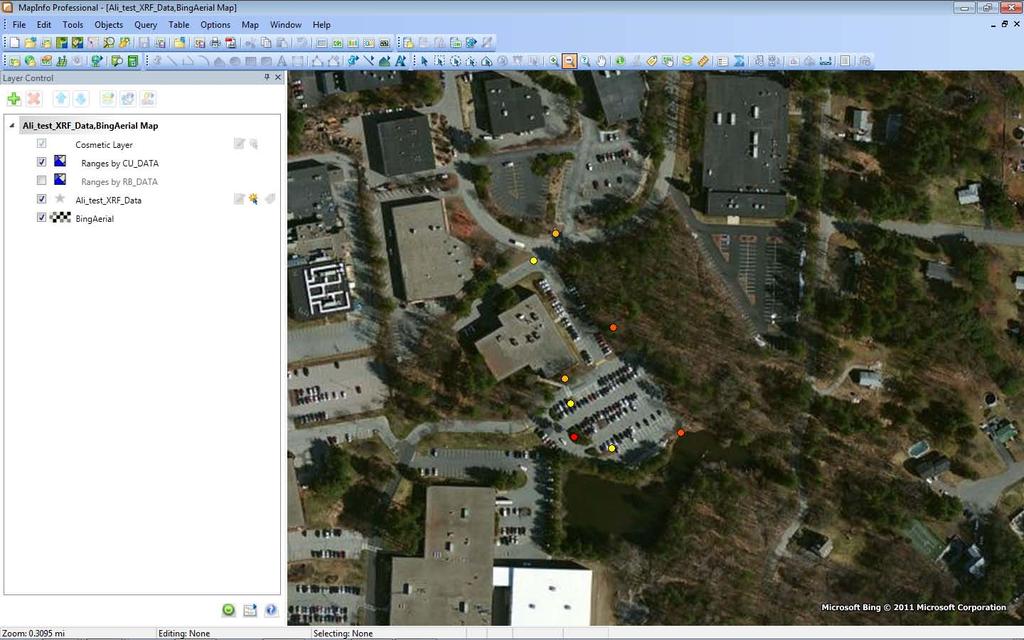
14 12) Geo-mapping: To show the location of samples on the Earth: File > Tile Sever Maps > Add Bing Aerial to Map 14

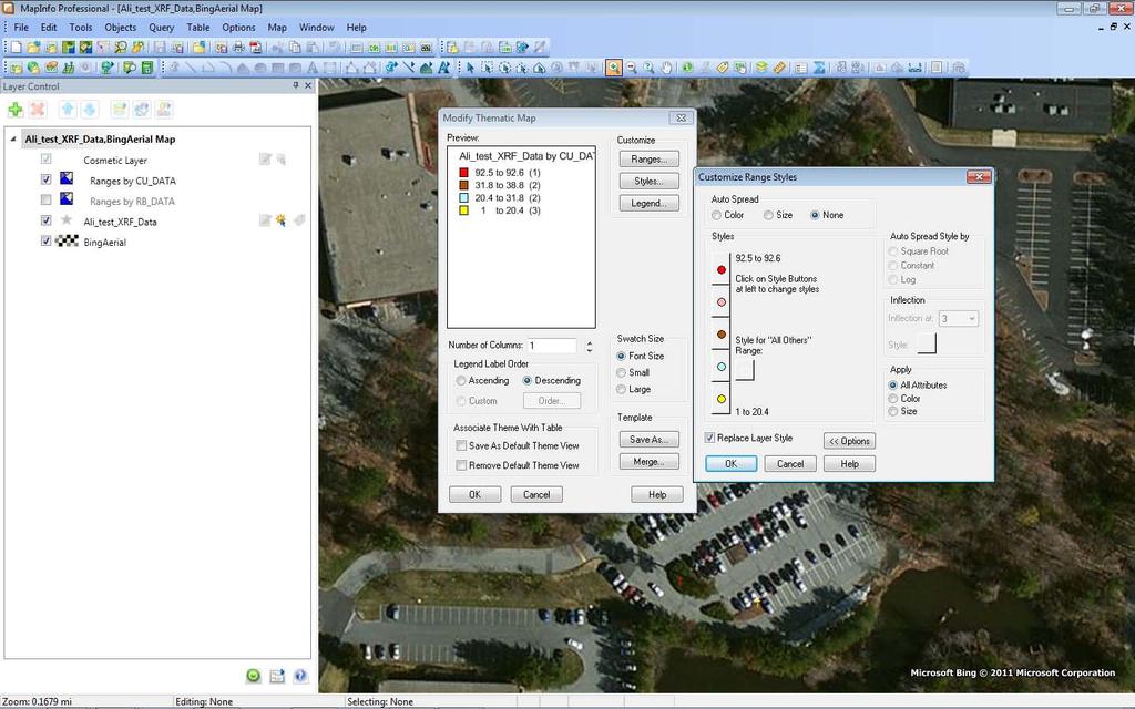
15 13) Elemental mapping using MapInfo on the computer: Map in menu > Create Thematic Map. A window (Create Thematic Map Step 1 of 3) appears. In this window, Select the desired method of elemental mapping, e.g., Type: Ranges > Template Name: Region Ranges, Solid Red-Yellow-Green > Next Another window (Create Thematic Map Step 2 of 3) appears where you select Table (e.g., Project in the example), and Field (the desired element) > Next In next window (Create Thematic Map Step 3 of 3), select desired options for ranges, styles, legend, color, font > OK The selected element s map will appear. You may modify the map: Map > Modify Thematic Map > select Thematic layer (the elemental map layer, e.g., Cu) > Modify > Styles (in the Modify Thematic Map window) > check All Attributes under Apply. You can also click on the symbol and change its shape and color, as desired. 15
16 16

. Discover Mobile will open it.")
, and Theme Fields")

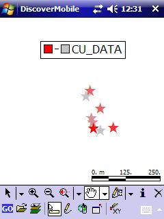
17 14) Elemental mapping using MapInfo in Trimble: Open folder > highlight the MapInfo Table (.tab) by holding and tapping on the file (Shown as Alitest in this example). Discover Mobile will open it. Go > Map > Create Theme. Then select Database, Type (Ranged), and Theme Fields (the desired element for elemental mapping) > Add The selected element s map will be created. Double tap on the legend to modify range, symbol, color, etc. 17
18 18

 > Port: COM9, Baud: 115200 > OK c.")
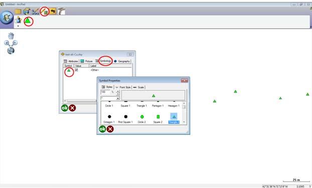
19 Geo-Mapping & Elemental Mapping Using Thermo Scientific Niton XRF and Trimble ArcPad 1) Start ArcPad In Trimble, follow steps below: a. Start > ArcPad > New Map > Main Tools> Options > Advanced Settings b. In the Advanced Setting window: AUX (tab) > Port: COM9, Baud: > OK c. Click on the analyzer icon (in menu) > Enable Capture of analyses (the icon will be highlighted) 19
 in the XRF Mode Selection window. For example: i.")

20 d. Click on Manage Analysis Layers > Create New (in the XRF Analysis Layers window) > Check desired elements, units, and mode (tab) in the XRF Mode Selection window. For example: i. Create New > Mining Cu/Zn mode > check Ni (and any other elements) > check PPM (Units) > ok ii. Highlight the desired element for elemental mapping > ok > Choose Symbol, Color By Element and Number of Ranges > ok > Choose desired ranges > ok > Save the file 20

 In the field: a.")
 > GPS Active > GPS Position Window (a window will open")

21 iii. If you like to use an existing layer, follow these steps: Manage Analysis Layers > Add Existing > click on the desired layer (then this layer will be added to the Active layers list) 2) In the field: a. In Trimble ArcPad, follow these steps: Main Tools > GPS Active (menu) > GPS Active > GPS Position Window (a window will open with a few submenus. Use the Quality tab to see the number of Satellites in solution/view. This should be at least 3/12. After getting enough satellites (at least 3), start using the analyzer. 21


22 b. In ArcPad, highlight the desired layer (e.g., Cu-test in this example). c. Shoot the sample with the Thermo Scientific Niton XRF analyzer for desired length of time; after releasing the trigger, a window appears in Trimble. In this window, use View Analysis to see the analysis, and if it is acceptable, click ok, and then click ok again. Then it goes to the ArcPad window. Now this analysis is saved in Trimble with GPS coordination. Follow this procedure for all samples in the field. d. NOTE: Follow the above step (View Analysis > ok > ok) for each analysis at the site of that sample. If you move and do this later at new location, the GPS coordination of the new location will be saved (not that of the original assayed sample). 22


23 e. In Trimble, ArcPad window, you can view the instant map based on the layer (element) of your choice and symbols that you have defined before. Use zoom in or out to view the map in desired scale. f. The symbol, color, and range can be modified in Trimble ArcPad. Main Tools > Table of Contents > Table of Contents window will open. Change the symbol and range as desired in the QuickCapture and Legend tabs. 3) Download data to your computer: a. Connect Trimble to your computer using USB 23
 are created and all of them are necessary to open a map. If any of them is deleted, ArcPad will not open the map.")
24 b. Find Trimble in the computer: My Computer > Trimble > My Documents > Download (e.g., by copy and paste) files (that were created during the use of the Trimble in the field) into My Documents. NOTE: For each map, four files (APL, DBF, SHP, SHX) are created and all of them are necessary to open a map. If any of them is deleted, ArcPad will not open the map. Do not rename these four files (APL, DBF, SHP, SHX). ArcPad will not open the map. c. In My Documents double click the file (either Shape file with extension.shp or Map file with extension.apm). It will be opened by ArcPad. If not, right click on the file > Open with > ArcPad. (You may need to find ArcPad program in your computer and click on it.) Use Zoom in/out (scroll with the mouse) to see the analyzed sites in desired scale. You may save this as a Map. The ArcPad Map (APM) file can be named differently. d. Viewing data and changing symbol: This can be done in two ways: Main Tools > Table of Contents > A window will open. Change the symbol and range as desired in the QuickCapture and Legend submenus. Quick Capture > Click on the symbol > double click on any analyzed point, a window will open showing the data for that point. 1. Symbology tab > click on Symbol sign > click on Symbol tab > chose desired symbol > ok > ok 24
25 25
 Select the rows that you want to show in the Google Earth mapping service. Use Control to select individual rows, and Shift to select more rows.")
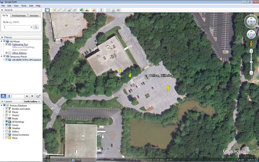
26 Presentation of Assay Data with GPS Coordination in Google Earth 1) Open.ndt file that contains assay data and GPS coordination. The Niton Data Transfer (NDT ) program will open this file. 2) Select the rows that you want to show in the Google Earth mapping service. Use Control to select individual rows, and Shift to select more rows. 3) Then Tools > Export to GIS format 4) Select Destination Folder: anywhere you like to save the file 5) Output File Name: Assign a name 6) Export Type: Scroll down and select *.KML (it is important to make sure that this is the chosen file type) 7) Start 8) In the same window, click Open Exported File. 9) Data points will be opened in Google Earth. 26
27 27
28 Presentation of Assay Data with GPS Coordination in ArcPad 1) Open the.ndt file that contains assay data and GPS coordination. The Niton Data Transfer program will open this file. 2) Select the rows that you want to show in Google Earth. Use Control to select individual rows, and Shift to select more rows. 3) Then Tools > Export to GIS format 4) Select Destination Folder: Save the file in My Documents. You can save this in any other folder however it is easier to find this file in My Document in ArcPad. 5) Output File Name: Assign a name 6) Export Type: Scroll down and select *.SHP (It is important to make sure that this is the chosen file type) 7) Start 8) Open ArcPad, then: Start > Add Layer 9) Find the saved file and check it. 28
29 10) Click ok then data points will appear. You may change magnification by scrolling with the mouse. 11) In order to show data points on aerial photo of earth: Main Tools > Add layer > Add Data from Server, and then check Bing-Maps-Aerial, then ok, then save the file. The data points will be shown in the aerial photo. 29
30 30


31 12) Now there are 2 layers, one the data points and one the aerial map. Use Main Tools > Table of Contents to check/uncheck any desired layer. 31
 On the analyzer: a. Turn on and Log in b. System > Bluetooth c.")
. Then Config > Type (scroll down) > GPS > Save > Connect.")
32 Bluetooth Connection of Trip Recorder 747 Pro GPS to Thermo Scientific Niton XRF Analyzer 1) Turn on Trip Recorder 747 Pro GPS. The blue light will blink. Make sure it is charged. Follow the instructions in the device manual for charging. 2) On the analyzer: a. Turn on and Log in b. System > Bluetooth c. If this is the first time pairing the analyzer with Trimble, follow these steps: System > Bluetooth > Search. It may take a few minutes until the analyzer finds Trip Recorder 747 Pro. After finding, click on the name of GPS device (Trip Recorder 747 Pro). Then Config > Type (scroll down) > GPS > Save > Connect. It may take 1-2 minutes; after the connection is made, the orange light on the GPS device will turn on, while the blue light will blink on both the analyzer and GPS. i. If the analyzer has been previously connected to this device, follow these steps: System > Bluetooth > Click on the name of device > Connect ii. Click on GPS and wait till Lat and Long numbers appear. d. Assay sample: Each time that the trigger is released, the GPS coordination is recorded in the NDT file. As long as there is a Bluetooth connection and the GPS is receiving satellite signals, the GPS coordination will be recorded in the NDT file. NOTE: GPS coordination is not displayed in the analyzer s analysis table. 32


33 2011 Thermo Fisher Scientific Inc. All rights reserved. ArcPad is a registered trademark of Esri in the United States, the European Community, or certain other jurisdictions. Bluetooth is a trademark of Bluetooth SIG, Inc. Trimble is a registered trademark of Trimble Navigation Limited. MapInfo is a registered trademark of Pitney Bowes MapInfo Corporation. Google Earth is a trademark of Google Inc. All other trademarks are the property of Thermo Fisher Scientific Inc. and its subsidiaries. Specifications, terms and pricing are subject to change. Not all products are available in all countries. Please consult your local sales representative for details. Figure on the cover page courtesy of 33
QUICK START GUIDE. SOLO Forest
 QUICK START GUIDE SOLO Forest Software Installation 1. For PC installation, run the.msi file. 2. For Mobile device installation, copy the.cab file onto the device 3. Run the.cab file Starting the Program
Functionality of CarryMap 5.2 application for Android devices
 Data East, LLC Functionality of CarryMap 5.2 application for Android devices Content Overview of buttons located on map window... 3 Creating new object... 3 Adding photo to object... 7 Measuring distance
WILD 2400 ASSIGNMENT #1: GPS TUTORIAL*
 WILD 2400 ASSIGNMENT #1: GPS TUTORIAL* Overview: In this tutorial you will learn how to collect, download, and display data using a Garmin GPSMAP 64 unit, the DNRGPS Application, and Google Earth. For
Guide to Mapping Website (Public) December 2016 GC_236594
 December 2016 GC_236594") Guide to Mapping Website (Public) December 2016 GC_236594 Table of Contents Guide to Mapping Website (Public)... 1 December 2016... 1 Quick Start... 3 Map Layers... 4 How do I?... 5 Draw on the Map...
Guide to Mapping Website (Public) December 2016 GC_236594 Table of Contents Guide to Mapping Website (Public)... 1 December 2016... 1 Quick Start... 3 Map Layers... 4 How do I?... 5 Draw on the Map...
Introduction to GIS software
 Introduction to GIS software There are a wide variety of GIS software packages available. Some of these software packages are freely available for you to download and could be used in your classroom. ArcGIS
Interactive Maps Purpose: Login to the System: Interactive Maps ONTINUE AGREE
 Interactive Maps Purpose: The purpose of this application is to provide the facility to the citizen to navigate to a Property through an On-line Free Web Application in real time. The application uses
GIS DATA SUBMISSION USER GUIDE. Innovation and Networks Executive Agency
 Innovation and Networks Executive Agency GIS DATA SUBMISSION USER GUIDE Innovation and Networks Executive Agency (INEA) W910 Chaussée de Wavre 910 B-1049 Brussels, Belgium Tel: +32 (0)2 29 95252 Fax: +32
Market Insight Geo Mapping User Guide v1.0
 Market Insight Geo Mapping v1.0 D&B Market Insight Geo Mapping Manual Version: 1.0 Software Version: System: 2017 Q3 Training (UK) Contents Introduction... 1 Data Structure... 2 How to Login... 3 Map Options...
City of La Crosse Online Mapping Website Help Document
 City of La Crosse Online Mapping Website Help Document This document was created to assist in using the new City of La Crosse online mapping sites. When the website is first opened, a map showing the City
Quick Start Guide for Using TDS NOMAD GPS Equipment (For Team Leaders) Initial Unit Check
 Initial Unit Check") Quick Start Guide for Using TDS NOMAD GPS Equipment (For Team Leaders) Initial Unit Check For each GPS unit, ensure you have: TDS NOMAD GPS Unit Garmin backpack receiver (antenna) Portable battery pack
Quick Start Guide for Using TDS NOMAD GPS Equipment (For Team Leaders) Initial Unit Check For each GPS unit, ensure you have: TDS NOMAD GPS Unit Garmin backpack receiver (antenna) Portable battery pack
Google Earth Tutorial 1: The Basics of Map-making in Google Earth 6.2
 Google Earth Tutorial 1: The Basics of Map-making in Google Earth 6.2 University of Waterloo Map Library, 2012 Part 1: Placemarks 1. Locating a Geographical Area a. Open up Google Earth. b. In the Search
Tutorial 1 Exploring ArcGIS
 Tutorial 1 Exploring ArcGIS Before beginning this tutorial, you should make sure your GIS network folder is mapped on the computer you are using. Please refer to the How to map your GIS server folder as
Photo2GPS Instructions:
 Photo2GPS Instructions: Photo2GPS is a program designed to read a text file of track points and the contents of a folder containing your digital photographs then create coordinates with links to the associated
Farm Works Mobile with Geonics Sensors
 Farm Works Mobile with Geonics Sensors Introduction. Farm Works Mobile is a mobile mapping, scouting and data logging program from Trimble. Farm Works Mobile is designed to communicate via an RS232 serial
Quick Start Guide for Using TDS NOMAD GPS Equipment (For Team Leaders) Initial Unit Check
 Initial Unit Check") Quick Start Guide for Using TDS NOMAD GPS Equipment (For Team Leaders) Initial Unit Check For each GPS unit, ensure you have: TDS NOMAD GPS Unit Garmin backpack receiver (antenna) Portable battery pack
Quick Start Guide for Using TDS NOMAD GPS Equipment (For Team Leaders) Initial Unit Check For each GPS unit, ensure you have: TDS NOMAD GPS Unit Garmin backpack receiver (antenna) Portable battery pack
Supply Chain Guru Network Optimization Tutorial. Version 8.2
 Supply Chain Guru Network Optimization Tutorial Version 8.2 Supply Chain Guru 8.2 Network Optimization Tutorial January 2015 Copyright 2015 LLamasoft, Inc. All Rights Reserved. PC*MILER and ALK are registered
Intro to GIS (requirements: basic Windows computer skills and a flash drive)
") Introduction to GIS Intro to GIS (requirements: basic Windows computer skills and a flash drive) Part 1. What is GIS. 1. System: hardware (computers, devices), software (proprietary or free), people. 2.
Introduction to GIS Intro to GIS (requirements: basic Windows computer skills and a flash drive) Part 1. What is GIS. 1. System: hardware (computers, devices), software (proprietary or free), people. 2.
Trimble Recon Handheld: Using the Socket Bluetooth CompactFlash Card
 31 August 2006 Trimble Recon Handheld: Using the Socket Bluetooth CompactFlash Card This document explains how to use the Socket Bluetooth CompactFlash card on the Trimble Recon handheld running the Microsoft
_Tutorials. Arcmap. Linking additional files outside from Geodata
 _Tutorials Arcmap Linking additional files outside from Geodata 2017 Sourcing the Data (Option 1): Extracting Data from Auckland Council GIS P1 First you want to get onto the Auckland Council GIS website
Using Google Earth. Middlebury College Library and Information Services
 Using Google Earth Middlebury College Introduction: While Google Earth can be a fun tool for simply looking at the surface of the earth, there are many other more sophisticated features to explore. Google
Introduction to Solo Forest
 Introduction to Solo Forest Project Settings Collecting Data Office Procedures - Exporting Shapefiles - Syncing with the PC - Transferring files Opening Solo Forest To open Solo Forest, select Start >
HCA ArcGIS. Online Tool - How To Guide V1.0 2/15/2016 HAWAII CONSERVATION ALLIANCE AGOL
 HCA ArcGIS 2/15/2016 Online Tool - How To Guide V1.0 HAWAII CONSERVATION ALLIANCE AGOL Table of Contents What is ArcGIS Online?... 1 Getting Started... 1 Getting a Login... 1 Logging In... 2 Searching
GIS DATA SUBMISSION USER GUIDE. Innovation and Networks Executive Agency
 Innovation and Networks Executive Agency GIS DATA SUBMISSION USER GUIDE Innovation and Networks Executive Agency (INEA) W910 Chaussée de Wavre 910 B-1049 Brussels, Belgium Tel: +32 (0)2 29 95252 Fax: +32
GeoLytics. User Guide. Online Demographic Database
 GeoLytics Online Demographic Database User Guide Introduction 1 Steps to Create a Report and Export Data 1 Creating & Naming a Request 2 Selecting an Area 3 Selecting the Subarea 5 Selecting Counts & Variables
User manual. TopoL Mobile 3.0. TopoL Software, s.r.o.
 User manual TopoL Mobile 3.0 TopoL Software, s.r.o. 2005-2012 TopoL Software, s.r.o. All rights reserved. TopoL is registered trade mark of TopoL Software, s.r.o. Obsah Content BASICS... 5 INSTALLATION...
1. Open PowerPoint and you will see the introductory screen that contains different themes and templates. From the selection displayed, choose Slice.
 PowerPoint Assessment ***Remember! This is a test and you cannot ask for help. This must be done completely on your own. If you have forgotten a skill, please go to my Tutorials page on my website and
In order to follow this set of directions you will need the following
 How to Create Maps & Figures in ArcView 9x In order to follow this set of directions you will need the following 1) the Jenny s Louisiana GIS Instructional CD 2) a computer with ArcGIS on it (version 9.0
Mapping 2001 Census Data Using ArcView 3.3
 Mapping 2001 Census Data Using ArcView 3.3 These procedures outline: 1. Mapping a theme (making a map) 2. Preparing the layout for printing and exporting the map into various file formats. In order to
Convert AutoCAD files to ESRI ShapeFiles, to be used in Leica icon telematics
 Convert AutoCAD files to ESRI ShapeFiles, to be used in 1 1 Convert AutoCAD files to ESRI ShapeFiles, to be used in Background When you use it is possible to log the machine's position and visualize this
Using Syracuse Community Geography s MapSyracuse
 Using Syracuse Community Geography s MapSyracuse MapSyracuse allows the user to create custom maps with the data provided by Syracuse Community Geography. Starting with the basic template provided, you
Each primary search has an auto-fill that will filter out results as the user continues to type.
 The Town of Farmville has recently requested a GIS parcel viewer and Timmons Group, based out of Richmond, VA, was selected to design and host this new website. This website allows users to look up parcel
Development Authority of the North Country (DANC) Internet Mapping Application Instructions Public Viewer 1. Purpose. 2. Logging-in. 3.
 Internet Mapping Application Instructions Public Viewer 1. Purpose. 2. Logging-in. 3.") Development Authority of the North Country (DANC) Internet Mapping Application Instructions Public Viewer 1. Purpose The purpose of this document is to outline basic functionality of the DANC Internet
Development Authority of the North Country (DANC) Internet Mapping Application Instructions Public Viewer 1. Purpose The purpose of this document is to outline basic functionality of the DANC Internet
Word 3 Microsoft Word 2013
 Word 3 Microsoft Word 2013 Mercer County Library System Brian M. Hughes, County Executive Action Technique 1. Insert a Text Box 1. Click the Insert tab on the Ribbon. 2. Then click on Text Box in the Text
Setup a VSN Survey Style Using Trimble Access (MiFi Card)
") Setup a VSN Survey Style Using Trimble Access (MiFi Card) California Surveying & Drafting Supply Technical Support Services Notes: This tutorial is designed for users with a MiFi Card/VSN Setup. In order
Setup a VSN Survey Style Using Trimble Access (MiFi Card) California Surveying & Drafting Supply Technical Support Services Notes: This tutorial is designed for users with a MiFi Card/VSN Setup. In order
Map & Locations 16 Using Google Maps Using HTC Footprints
 Map & Locations 16 Using Google Maps...16-2 Turning on Location Services... 16-2 Opening Maps... 16-2 Searching for a Location... 16-3 Getting Directions... 16-3 Finding Friends with Google Latitude...
Explore some of the new functionality in ArcMap 10
 Explore some of the new functionality in ArcMap 10 Scenario In this exercise, imagine you are a GIS analyst working for Old Dominion University. Construction will begin shortly on renovation of the new
Thermo Scientific Portable XRF Analyzers
 Thermo Scientific Portable XRF Analyzers Bluetooth Troubleshooting Guide January 2012 Rev. 1 Presentation MUST BE in Slide Show Mode for Hyperlinks to Work Before proceeding: verify the software version!
4) Study the section of a worksheet in the image below. What is the cell address of the cell containing the word "Qtr3"?
 Study the section of a worksheet in the image below. What is the cell address of the cell containing the word Qtr3?") Choose The Correct Answer: 1) Study the highlighted cells in the image below and identify which of the following represents the correct cell address for these cells: a) The cell reference for the selected
Choose The Correct Answer: 1) Study the highlighted cells in the image below and identify which of the following represents the correct cell address for these cells: a) The cell reference for the selected
HBS Training - IT Solutions. PlanWeb. Intermediate
 HBS Training - IT Solutions PlanWeb Intermediate CONTENTS Logging on to the system...3 The PlanWeb Window...5 The Tool Bar...6 The Status Bar...6 The Map Window...6 The Information Window...7 Changing
VANGUARD LOAD TAP CHANGER ANALYZER (LTCA) VERSION 2.xx SOFTWARE MANUAL. LTCA-10, LTCA-40, WRM-10P, WRM-40, TRM-20, TRM-40, TRM-203, and TRM-403
 VERSION 2.xx SOFTWARE MANUAL. LTCA-10, LTCA-40, WRM-10P, WRM-40, TRM-20, TRM-40, TRM-203, and TRM-403") VANGUARD LOAD TAP CHANGER ANALYZER (LTCA) VERSION 2.xx SOFTWARE MANUAL For Use with Vanguard s LTCA-10, LTCA-40, WRM-10P, WRM-40, TRM-20, TRM-40, TRM-203, and TRM-403 Load Tap Changer Analyzers and Winding
VANGUARD LOAD TAP CHANGER ANALYZER (LTCA) VERSION 2.xx SOFTWARE MANUAL For Use with Vanguard s LTCA-10, LTCA-40, WRM-10P, WRM-40, TRM-20, TRM-40, TRM-203, and TRM-403 Load Tap Changer Analyzers and Winding
Overview. Cisco Cius User Guide 1
 Overview This chapter outlines the features of Cisco Cius. The chapter covers these topics: Hardware, page 2 Features, page 10 Figure 1 shows the Cisco Cius. Figure 1 Cisco Cius Cisco Cius User Guide 1
Full Search Map Tab Overview
 FlexMLS Map Server Full Search Map Tab Overview The Full Search Map tab is a need to know module. It is accessible when you use Full Search under Search in the Main Menu tree of FlexMLS. This map can
OziExplorer Training and Help Manual for Use with Soil Resource Stewardship Monitoring Checklist: Cutblock-Level
 OziExplorer Training and Help Manual for Use with Soil Resource Stewardship Monitoring Checklist: Cutblock-Level Stéphane Dubé, Soil Scientist MOFR Northern Interior Forest Region May 2009 Version 2 Starting
zuvo User Guide For zuvo -D Speech-Generating Devices Find more resources online:
 zuvo User Guide TM For zuvo -D Speech-Generating Devices Find more resources online: www.talktometechnologies.com/support/ Table of contents Technical Hardware and features... 2 Speech settings... 3 Take
2. In the Start and End Dates section, use the Calendar icon to change the Displayed Start Date to 1/1/2015 and the Displayed End Date to 5/31/2015.
 Tutorials Lesson 1 - Format a Schedule In this lesson you will learn how to: Change the schedule s date range. Change the date headings. Change the schedule dimensions. Change the legend and add a new
Getting Started with the new GIS Map Service Overview:
 Getting Started with the new GIS Map Service Overview: 1. Layer List Widget Shows all available layers. This widget will be open by default. 2. Legend Widget Gives symbology information for all visible
Exercise 1: Introduction to MapInfo
 Geog 578 Exercise 1: Introduction to MapInfo Page: 1/22 Geog 578: GIS Applications Exercise 1: Introduction to MapInfo Assigned on January 25 th, 2006 Due on February 1 st, 2006 Total Points: 10 0. Convention
Akkadian Console 4.0
 Akkadian Console 4.0 User Guide Copyright and Trademarks: I. Copyright: This website and its content is copyright 2015 Akkadian Labs, LLC. All rights reserved. Except with the prior written permission
Exercise 4: Import Tabular GPS Data and Digitizing
 Exercise 4: Import Tabular GPS Data and Digitizing You can create NEW GIS data layers by digitizing on screen with an aerial photograph or other image as a back-drop. You can also digitize using imported
This document describes the various enhancements and modifications to DRM Windows that occurred between versions and
 This document describes the various enhancements and modifications to DRM Windows that occurred between versions 8.3.260 and 9.1.270. New Feature: Customer Mapping The mapping feature lets you interact
Updating the operating system and BONGO (MCU) firmware
 firmware") RELEASE NOTES Trimble Juno T41, Juno 5, Slate Controller, and Spectra Precision T41 Series: Windows Embedded Handheld (WEH) 6.5 Operating System Release Notes and Update Instructions These release notes
RELEASE NOTES Trimble Juno T41, Juno 5, Slate Controller, and Spectra Precision T41 Series: Windows Embedded Handheld (WEH) 6.5 Operating System Release Notes and Update Instructions These release notes
Thermo Scientific. GRAMS Envision. Version 2.1. User Guide
 Thermo Scientific GRAMS Envision Version 2.1 User Guide 2013 Thermo Fisher Scientific Inc. All rights reserved. Thermo Fisher Scientific Inc. provides this document to its customers with a product purchase
STUDENT PAGES GIS Tutorial Treasure in the Treasure State
 STUDENT PAGES GIS Tutorial Treasure in the Treasure State Copyright 2015 Bear Trust International GIS Tutorial 1 Exercise 1: Make a Hand Drawn Map of the School Yard and Playground Your teacher will provide
Press the Plus + key to zoom in. Press the Minus - key to zoom out. Scroll the mouse wheel away from you to zoom in; towards you to zoom out.
 Navigate Around the Map Interactive maps provide many choices for displaying information, searching for more details, and moving around the map. Most navigation uses the mouse, but at times you may also
Manitowoc County, WI Advanced Access GIS Viewer User Documentation
 Manitowoc County, WI Advanced Access GIS Viewer User Documentation Introduction Extensive time was put into developing this website both from a display, and from a printing and scaling perspective. This
Visual Studies Exercise.Topic08 (Architectural Paleontology) Geographic Information Systems (GIS), Part I
 Geographic Information Systems (GIS), Part I") ARCH1291 Visual Studies II Week 8, Spring 2013 Assignment 7 GIS I Prof. Alihan Polat Visual Studies Exercise.Topic08 (Architectural Paleontology) Geographic Information Systems (GIS), Part I Medium: GIS
ARCH1291 Visual Studies II Week 8, Spring 2013 Assignment 7 GIS I Prof. Alihan Polat Visual Studies Exercise.Topic08 (Architectural Paleontology) Geographic Information Systems (GIS), Part I Medium: GIS
Getting Started with MapInfo Professional Hands On Session 1D
 In this session, the following topics will be covered: Open a DBF file Create Points Geocode to 5 digit ZIPCodes Use Query > Select Use the Select Tools Create a Thematic Map The Layout Window MapWorld
Overview of ArcGIS Online Applications. Champaign County
 Overview of ArcGIS Online Applications Champaign County Champaign County GIS Consortium Updated: April 2017 Table of Contents ArcGIS Online Application Overview... 3 Map Interface Symbology and Terminology...
Objectives Learn how to work with projections in GMS, and how to combine data from different coordinate systems into the same GMS project.
 v. 10.2 GMS 10.2 Tutorial Working with map projections in GMS Objectives Learn how to work with projections in GMS, and how to combine data from different coordinate systems into the same GMS project.
Basic Mapping: Livelihood Zones In Haiti
 Basic Mapping: Livelihood Zones In Haiti - 2009 Barbara Parmenter, revised by Carolyn Talmadge 9/10/2016 DATA SOURCES... 1 MAPPING NETWORK DRIVES OUTSIDE THE DATA LAB... 2 SETTING UP YOUR ARCMAP SESSION...
TxEIS on Internet Explorer 8
 TxEIS on Internet Explorer 8 General Set Up Recommendations: Several modifications will need to be made to the computer settings in Internet Explorer to ensure TxEIS runs smoothly, reports pop up as desired,
Topcon GRS-1 1 Receiver Field Preparation
 Topcon GRS-1 1 Receiver Field Preparation What do you need to know to get started with your Topcon GRS-1? Topcon GRS-1 Receiver - Field Preparation Some Common Questions Which TopSURV modules do I buy?
MapInfo ProViewer 11.0 USER GUIDE
 MapInfo ProViewer 11.0 USER GUIDE Information in this document is subject to change without notice and does not represent a commitment on the part of the vendor or its representatives. No part of this
Basic Mapping: Livelihood Zones In Haiti
 Basic Mapping: Livelihood Zones In Haiti - 2009 Barbara Parmenter, revised by Carolyn Talmadge 9/10/2017 for ArcMap 10.5.1 DATA SOURCES... 1 MAPPING NETWORK DRIVES OUTSIDE THE DATA LAB... 2 SETTING UP
OpenForms360 Validation User Guide Notable Solutions Inc.
 OpenForms360 Validation User Guide 2011 Notable Solutions Inc. 1 T A B L E O F C O N T EN T S Introduction...5 What is OpenForms360 Validation?... 5 Using OpenForms360 Validation... 5 Features at a glance...
PRODUCT DATA sheet. MapInfo Professional v12 Version Comparison. How Does v12 Compare to Previous Versions? MapInfo Professional v12 adds: SUMMARY
 PRODUCT DATA sheet MapInfo Professional v12 Version Comparison work smarter, not harder, with the premier location intelligence solution How Does v12 Compare to Previous Versions? MapInfo Professional
Trimble Access: OSTN15 Transformation Update Procedure (Ireland)
") Trimble Access: OSTN15 Transformation Update Procedure (Ireland) This guide is for use with Trimble Access version 2016.03 & previous versions Prerequisites: Access Controller (Nb. TSC3 used in this guide)
Trimble Access: OSTN15 Transformation Update Procedure (Ireland) This guide is for use with Trimble Access version 2016.03 & previous versions Prerequisites: Access Controller (Nb. TSC3 used in this guide)
FREEDOM-Pad Installation and Operation
 FREEDOM-Pad Installation and Operation Quick Start Steps for installing FREEDOM-Pad Page 2 Desktop Install Overview Page 2 Mobile Device Installation Overview Page 2 Activating the Battery Page 2 Resetting
Field PC 2 Windows OS Update Guide
 Field PC 2 Windows OS Update Guide All efforts have been made to ensure the accuracy and completeness of the information contained in this document. RST Instruments Ltd reserves the right to change the
KDHE Watershed Management Web Map Editor Standard Operating Procedures (SOP) A. How to get Watershed Assignment? a. View Watershed Status
 A. How to get Watershed Assignment? a. View Watershed Status") KDHE Watershed Management Web Map Editor Standard Operating Procedures (SOP) A. How to get Watershed Assignment? a. View Watershed Status B. How to prepare web map for editing. a. Change visible Layers
KDHE Watershed Management Web Map Editor Standard Operating Procedures (SOP) A. How to get Watershed Assignment? a. View Watershed Status B. How to prepare web map for editing. a. Change visible Layers
itrail Endurance User s Manual
 itrail Endurance User s Manual 1 What s Inside itrail Endurance device Wall Charger & Cable MEID Number (located on box and device) 2 itrail Endurance 1. Charging Port & Cover 2. LED Indicator Light 3.
Smart GIS Course. Developed By. Mohamed Elsayed Elshayal. Elshayal Smart GIS Map Editor and Surface Analysis. First Arabian GIS Software
 Smart GIS Course Developed By Mohamed Elsayed Elshayal Elshayal Smart GIS Map Editor and Surface Analysis First Arabian GIS Software http://www.freesmartgis.blogspot.com/ http://tech.groups.yahoo.com/group/elshayalsmartgis/
Technical Specifications
 1 Contents INTRODUCTION...3 ABOUT THIS LAB...3 IMPORTANCE OF THIS MODULE...3 EXPORTING AND IMPORTING DATA...4 VIEWING PROJECTION INFORMATION...5...6 Assigning Projection...6 Reprojecting Data...7 CLIPPING/SUBSETTING...7
Geographical mapping of data
 BioNumerics Tutorial: Geographical mapping of data 1 Aim In many research projects, especially epidemiological, biological data is closely linked to geographical data. Geographical information provided
QuickStart Guide MindManager 7 MAC
 QuickStart Guide MindManager 7 MAC Contents Welcome to Mindjet MindManager...... 1 Technical Support and Registration... 1 About this User Guide............... 1 Learn about MindManager and maps... 2 What
INTRODUCTION TO GIS WORKSHOP EXERCISE
 111 Mulford Hall, College of Natural Resources, UC Berkeley (510) 643-4539 INTRODUCTION TO GIS WORKSHOP EXERCISE This exercise is a survey of some GIS and spatial analysis tools for ecological and natural
Geographical Information Systems Institute. Center for Geographic Analysis, Harvard University. LAB EXERCISE 1: Basic Mapping in ArcMap
 Harvard University Introduction to ArcMap Geographical Information Systems Institute Center for Geographic Analysis, Harvard University LAB EXERCISE 1: Basic Mapping in ArcMap Individual files (lab instructions,
v SMS 11.1 Tutorial GIS Requirements GIS Module Map Module ArcGis (Optional) Time minutes Prerequisites None Objectives
 Time minutes Prerequisites None Objectives") v. 11.1 SMS 11.1 Tutorial GIS Objectives This tutorial demonstrates how you can read in GIS data, visualize it, and convert it into SMS coverage data that could be used to build a numeric model. We will
v. 11.1 SMS 11.1 Tutorial GIS Objectives This tutorial demonstrates how you can read in GIS data, visualize it, and convert it into SMS coverage data that could be used to build a numeric model. We will
User manual. SmartPSS. Manual includes
 User manual software is used for viewing, playing back and exporting video footage from IP video surveillance systems. Manual includes Logging In Starting Live View Adding a Custom View Using Digital Zoom
Maxwell RSC Tablet PC Configuration Manual for use with Windows 8 Operating System
 Maxwell RSC Tablet PC Configuration Manual for use with Windows 8 Operating System TM537 1/18 Table of Contents 1 Maxwell RSC Instrument and Tablet PC...1 2 Glossary...3 3 Adjusting Volume Settings...5
Setup and Configuration
 Setup and Configuration OmniStream TM Solution Guide OmniStream Atlona Setup Guide Version Information Version Release Date Notes 1 02/19 Initial release 2 03/19 Audio added 3 03/19 USB added OmniStream
PlaceMap. Accommodation. Slide 1
 PlaceMap for Accommodation Slide 1 PlaceMap Using the power of Google Earth to store and display all of your spatial data in a much more dynamic way Google Earth is a free software program that lets you
Accessing the Web Interface on an SPSx50/x51 GPS Receiver using Bluetooth Wireless Technology
 16 April 2007 Accessing the Web Interface on an SPSx50/x51 GPS Receiver using Bluetooth Wireless Technology Summary This document describes how to access the web interface on a SPSx50/x51 Modular GPS receiver
Biodiversity GIS (BGIS) Internet Mapping User Guide
 Internet Mapping User Guide") Biodiversity GIS (BGIS) Internet Mapping User Guide http://bgis.sanbi.org Contents 1 Basic Introduction to BGIS Website (http://bgis.sanbi.org)... 6 1.1 LUDS... 6 1.2 Projects... 6 1.3 Services... 6 1.4
Biodiversity GIS (BGIS) Internet Mapping User Guide http://bgis.sanbi.org Contents 1 Basic Introduction to BGIS Website (http://bgis.sanbi.org)... 6 1.1 LUDS... 6 1.2 Projects... 6 1.3 Services... 6 1.4
ekaizen Lessons Table of Contents 1. ebook Basics 1 2. Create a new ebook Make Changes to the ebook Populate the ebook 41
 Table of Contents 1. ebook Basics 1 2. Create a new ebook 20 3. Make Changes to the ebook 31 4. Populate the ebook 41 5. Share the ebook 63 ekaizen 1 2 1 1 3 4 2 2 5 The ebook is a tabbed electronic book
User Manual. Consumer OneClick Internet. for Gobi Sierra Version st May 2010
 User Manual Consumer OneClick Internet for Gobi 2000 Sierra Version 1.8 21 st May 2010 WebToGo Mobiles Internet GmbH 81371 München, Oberländerstr. 2a Table of Content 1. General 2. Starting OneClick Connection
IHS Enerdeq Desktop International Training Guide
 IHS > Decision Support Tool IHS Enerdeq Desktop International Training Guide May 2009 Version 1.5.2 2009 IHS, All Rights Reserved. All trademarks belong to IHS or its affiliated and subsidiary companies,
End User Guide. 2.1 Getting Started Toolbar Right-click Contextual Menu Navigation Panels... 2
 TABLE OF CONTENTS 1 OVERVIEW...1 2 WEB VIEWER DEMO ON DESKTOP...1 2.1 Getting Started... 1 2.1.1 Toolbar... 1 2.1.2 Right-click Contextual Menu... 2 2.1.3 Navigation Panels... 2 2.1.4 Floating Toolbar...
ArcGIS Online Tutorial
 ArcGIS Online Tutorial ArcGIS Online allows users to make interactive maps or applications and easily share them with others. The University of Minnesota has an organizational account that can be logged
LEGENDplex Data Analysis Software Version 8 User Guide
 LEGENDplex Data Analysis Software Version 8 User Guide Introduction Welcome to the user s guide for Version 8 of the LEGENDplex data analysis software for Windows based computers 1. This tutorial will
Media Mapper Mobile Iteration #10 updated mockups
 Topic Media Mapper Mobile Iteration #10 updated mockups By Martha Roden November 14, 2013 Quick Overview 2 What Does MMM Do? (diagram) 3 Startup and Home Screens 4 Home > GPS Details & Point of Interest
Excel 2013 Intermediate
 Excel 2013 Intermediate Quick Access Toolbar... 1 Customizing Excel... 2 Keyboard Shortcuts... 2 Navigating the Spreadsheet... 2 Status Bar... 3 Worksheets... 3 Group Column/Row Adjusments... 4 Hiding
Windows 7 Basic Computer Course
 Windows 7 Basic Computer Course Windows 7 is the latest user operating system. This course covers everything you need to know about the current technology. FIRST TIME COMPUTER USERS If you have never used
Major features Support multi-language Automatically match photo and GPS tracks by time synchronization. Add photo comments.
 Users Manual V1.1 Users Manual Major features Read GPS log from device Add Photo and photo management Auto match photo and waypoints in tracks Shift photo time View in Google earth Save as kmz file GeoTag
1. Introduction P Package Contents 1.
 1 Contents 1. Introduction ------------------------------------------------------------------------------- P. 3-5 1.1 Package Contents 1.2 Tablet Overview 2. Using the Tablet for the first time ---------------------------------------------------
Setup a VSN Survey Style Using Trimble Access (Bluetooth Phone)
") Setup a VSN Survey Style Using Trimble Access (Bluetooth Phone) California Surveying & Drafting Supply Technical Support Services Notes: This tutorial is designed as a tutorial for users with a cell phone/vsn
Setup a VSN Survey Style Using Trimble Access (Bluetooth Phone) California Surveying & Drafting Supply Technical Support Services Notes: This tutorial is designed as a tutorial for users with a cell phone/vsn
AKCess Pro Server Access Control User Manual
 www.akcp.com AKCess Pro Server Access Control User Manual Help Version updated till version 118 Copyright 2012, AKCess Pro Co., Ltd.. 1) Introduction A) What is the AKCess Pro Server / Access Control?
Ctrack Online User Guide
 Fleetstar Online A Guide to Winter Maintenance Reporting v1.1 Ctrack Online User Guide Title: Ctrack Online Quickstart Guide Date: 18/07/2013 Version: 1.0 Table of Contents 1. Ctrack Online Introduction...
Display Systems International Software Demo Instructions
 Display Systems International Software Demo Instructions This demo guide has been re-written to better reflect the common features that people learning to use the DSI software are concerned with. This
VisionTouch 5 Software
 User Manual VisionTouch 5 Software Greengate Contents Contents Description General Information.... 3 Hardware and Software Requirements.... 3 Hardware Requirements.... 3 Software Requirements... 3 VisionTouch