The challenge of creating an INSPIRE Transport Networks DB from existing data in the National Geographic Institute of Spain
|
|
|
- Melissa Powell
- 5 years ago
- Views:
Transcription


1 The challenge of creating an INSPIRE Transport Networks DB from existing data in the National Geographic Institute of Spain Alicia González Jiménez Instituto Geográfico Nacional 1
2 Index Introduction: Why Geographic Reference Information of Transport Networks (IGNE_TN): data model definition Data production plannig: How and When Stateof theplayof thedb firstversion Conclusions 2

3 Introduction why? 3


4 Introduction IGN Spain production: So far: production based on cartographic products (e.g Topographic dataset at different scales, street map, etc.): 4
 but with different spatial and temporal update schedules: unit: municipality unit: map sheet update planning: more focus on the geographical areas than on geographical objetcs Consecuence: It is")
5 Introduction IGN Spain production: So far: production based on cartographic products (e.g Topographic dataset at different scales, street map, etc.) which: have several themes in common (e.g. transports, hydrography, etc.) but with different spatial and temporal update schedules: unit: municipality unit: map sheet update planning: more focus on the geographical areas than on geographical objetcs Consecuence: It is difficult to provide one unique thematic layer (e.g transport) containing the most complete, accurate and update data 5
6 Introduction How has IGN Spain worked to provide INSPIRE compliant Transport Network data? Identifying the IGN datasets containing the most representative Transport Network data Comparing and mapping those datasets data model with INSPIRE data model Any national dataset isolated is not as complete as TN INSPIRE data model Some national datasets contains more information than INSPIRE data model in specific topics Providing only the mapped data according to INSPIRE schema by means of: Download services WFS Visualizing services WMS, WMTS 6


7 Introduction How has IGN Spain worked to provide INSPIRE compliant Transport Network data? WMS_INSPIRE services: One service with both portrayals WMS INSPIRE 1.3.0: inspire/ign base Layers: TN.CommonTransportElements.TransportNode TN.RailTransportNetwork.RailwayLink TN.RoadTransportNetwork.RoadLink IGN Spain portrayal INSPIRE portrayal 7


8 Introduction User requirements on TN are not been fully satisfied March 2014: New IGN production strategy Design and creation of the Geographic Reference Information DB on TN: INSPIRE compliant Considering the national datasets requirements regarding TN > any TN data contained in these products must be derived from the TN reference BD It should be as much accurate and update as it is feasible 8


9 Geographic Reference Information on Transport Network (IGNE_TN): Data model definition 9
 BTN25 (Topographic D 1:25.000) BTN100 (Topographic D 1:100.")

10 IGNE_TN: Data model definition 1 st PHASE: Analysis of the lgn datasets requirements and their data models: Main products with TN data CartoCiudad (street map) BTN25 (Topographic D 1:25.000) BTN100 (Topographic D 1: ) SIGNA (National GIS) Exchange Data Model of Topographic data between IGN and the Spanish Regions Cartographic Agencies Official Data Providers Data models: Roads Ministry, Traffic Department, Railway Manager, etc. >1st result: Identification of the features, attributes, values and relationships required by the IGN datasets and needed to make easier the data flow with the official data providers 10
11 IGNE_TN: Data model definition 2 nd PHASE: INSPIRE compliant data model Main INSPIRE requirements: Network data model 5 transports networks Road TN Railway TN Water TN Air TN Cable TN Transport Infrastructures Intermodal connections + IGN datasets requirements: Features, attributes, values and relationships identified in National Products > 2nd result: Mapping tables between INSPIRE and National requirements Starting point to define the IGNE_TN conceptual model 11

12 IGNE_TN: Data model definition 3 rd PHASE: Create an application schema INSPIRE compliant: IGNE_Transport Network From INSPIRE Application Schema of Transport Network files imported in the Enterprise Architect software 12

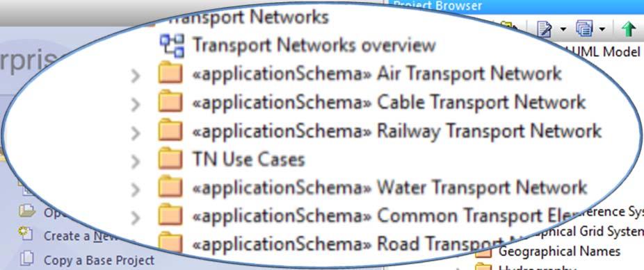

13 IGNE_TN: Data model definition 13
14 IGNE_TN: Data model definition Application schema: IGNE_Transport Network Composed of 6 schemas: one for the common elements and one per each transport mode: ApplicationSchema IGNE_Common Transport Network: ApplicationSchema IGNE_Air Transport Network ApplicationSchema IGNE_Cable Transport Network ApplicationSchema IGNE_Railway Transport Network ApplicationSchema IGNE_Road Transport Network ApplicationSchema IGNE_Water Transport Network The initial application schema has been extended adding some feature types and codelists values 14
15 IGNE_TN: Data model definition Application schema: IGNE_Transport Network It is documented in the IGNE_TN specifications and described by means of UML diagrams, similar to the INSPIRE specification: Every TN mode, according to its characteristics, is represented with the following UML diagrams: Network diagram Properties associated to the transportlink features diagram Properties associated to the transportlinkset features diagram Infrastructures properties diagram Example: UML diagram to represent the Road TN application schema 15


16 IGNE_TN: Data model definition Application schema: IGNE_Transport Network In the UML diagrams: Distinguishing the 3 levels: network, common elements, specific TN model Data model extentions: orangecoloured classes Applicable INSPIRE values applicable: pointed out in comments Example: Part of the IGNE_Road Transport Network UML diagram 16
: RT")


17 IGNE_TN: Data model definition 4rd PHASE: To document IGNE_Transport Network (RT): RT Specifications compliant with ISO Application Schema documented by: UML Diagrams Feature catalogue Annex: DB implementation: tables of physical datamodel Mapping tables with INSPIRE 17

18 Data Production Planning: How and When 18
19 Data production: How and When Geographic Reference Information production planning: 2 PHASES 1 ST : The DB first version is populated from existing data TN HY AU GN x x x x x x x x 19
20 Data production: How and When Geographic Reference Information of TN production:2 PHASES 1 ST :The DB first version is populated from existing data 2 nd : The DB second version: data are updated and improved in accuracy and it feeds the national datasets TN layers GRITN GRIHY GRIAU GRI 20


21 IGNE_Transport Network: DB First Version 21
22 IGNE_Transport Network: DB First Version Integration of the existing data according to IGNE_Transport Network requirements: o New features types, attributes and relationships: e.g intermodal connexions Challenge: to produce TN data for the whole Spain territory o Currently: the production phase is finished and data are being checked with the quality controls > data available in the first mid of 2017 Other actions on going: the implementation of WMS and WFS INSPIRE services 22


23 IGNE_Transport Network: DB First Version IGNE_TN V 0.1: Result of the data integration 23
24 Conclusions To be INSPIRE compliant does not imply a new production data but it should be considered as a promoter to rethink about the traditional production methodologies of G.R.I.: To be more efficient > do not duplicate data capture > reuse data To provide the data and services that users requiered currently: continuous, accurate and update transport network data 24
25 Thank you very much questions? Alicia González National Geographic Institute of SPAIN National Center of Geographic Information 25
INSPIRE Download Services of the CNIG (Spain) Emilio López Romero
 Emilio López Romero") INSPIRE Download Services of the CNIG (Spain) Emilio López Romero 1 The beginning One day, few years ago, we decided to implement INSPIRE seriously 2 The sources The first step was to identify the available
INSPIRE Download Services of the CNIG (Spain) Emilio López Romero 1 The beginning One day, few years ago, we decided to implement INSPIRE seriously 2 The sources The first step was to identify the available
How to Create a European INSPIRE Compliant Data Specification. Anja Hopfstock, BKG (Germany) Morten Borrebæk, SK (Norway)
 Morten Borrebæk, SK (Norway)") How to Create a European INSPIRE Compliant Data Specification Anja Hopfstock, BKG (Germany) Morten Borrebæk, SK (Norway) ESDIN Key Goals Further the ambition of the European Commission to create a European
How to Create a European INSPIRE Compliant Data Specification Anja Hopfstock, BKG (Germany) Morten Borrebæk, SK (Norway) ESDIN Key Goals Further the ambition of the European Commission to create a European
European Location Framework (ELF) acting as a facilitator implementing INSPIRE
 acting as a facilitator implementing INSPIRE") www.eurogeographics.org European Location Framework (ELF) acting as a facilitator implementing INSPIRE Saulius Urbanas, Mick Cory (EuroGeographics) 29 October 2016 Copyright 2013 EuroGeographics EuroGeographics
www.eurogeographics.org European Location Framework (ELF) acting as a facilitator implementing INSPIRE Saulius Urbanas, Mick Cory (EuroGeographics) 29 October 2016 Copyright 2013 EuroGeographics EuroGeographics
DATA VALIDATION AGAINST SCHEMA AND SOURCE DATA
 DATA VALIDATION AGAINST SCHEMA AND SOURCE DATA didier.bouteloup@ign.fr; dominique.laurent@ign.fr 3 June 2016 ign.fr Context IGN has performed data validation twice On test INSPIRE data (2013-2014) On ELF
ELF extensions. Presentation to: INSPIRE MIG-T. Author: Anja Hopfstock (ELF WP2 Data Specifications) Date: 25 th February 2016.
 Date: 25 th February 2016.") ELF extensions Presentation to: Author: Date: INSPIRE MIG-T Anja Hopfstock (ELF WP2 Data Specifications) 25 th February 2016 What is ELF in connection to INSPIRE? Arrangements within NMCAs in Europe to
ELF extensions Presentation to: Author: Date: INSPIRE MIG-T Anja Hopfstock (ELF WP2 Data Specifications) 25 th February 2016 What is ELF in connection to INSPIRE? Arrangements within NMCAs in Europe to
Experience federating the metadata catalogue of IGN in the Spanish Open Data Portal
 Experience federating the metadata catalogue of IGN in the Spanish Open Data Portal Paloma Abad E. López, A.F. Rodríguez, A. Sánchez, S. Castro, S. Soriano, J.I Sánchez 1 Summary IGN Metadata Catalogue
HUMBOLDT Application Scenario: Protected Areas
 CC by Erlend Schei Copyright by Kecko Copyright by Michael Bezzina CC by Gunnar Ries Copyright by Michael Bezzina Copyright by Michael Bezzina Copyright by Michael Bezzina CC by fs999 CC by Jordan Nielsen
ELF download services
 ELF download services Presentation to: Author: Date: ELF workshop in Moldova Marcin Grudzień 8 h September2015 14 September, 2015 Plan Introduction Specification documents The envisaged production process
Addressing the needs of INSPIRE: The Challenges of improving Interoperability within the European Union
 Addressing the needs of INSPIRE: The Challenges of improving Interoperability within the European Union Andrew Coote Facilitator, Addresses Thematic Working Group andrew.coote@consultingwhere.com Disclaimer
Introduction to INSPIRE. Network Services
 Introduction to INSPIRE. Network Services European Commission Joint Research Centre Institute for Environment and Sustainability Digital Earth and Reference Data Unit www.jrc.ec.europa.eu Serving society
Methodological approach for cross-theme harmonization of Polish spatial data sets the case study for the Annex I themes
 Methodological approach for cross-theme harmonization of Polish spatial data sets the case study for the Annex I themes Elżbieta Bielecka, Agnieszka Zwirowicz-Rutkowska, Alina Kmiecik, Marek Brylski, Magdalena
ADMINISTRATIVE UNITS INSPIRE KEN WORKSHOP TRANSFORMATION OF THEMES AD, AU, BU, CP AND GN April 2015 ign.
 ADMINISTRATIVE UNITS INSPIRE KEN WORKSHOP TRANSFORMATION OF THEMES AD, AU, BU, CP AND GN dominique.laurent@ign.fr 16-17 April 201 ign.fr Plan Source data Transformation choices and issues Conclusions Source
National Geographic Institute
 National Geographic Institute National Center for Geographic Information A specific website for metadata in Spain: MD Geoportal Alejandra Sánchez Maganto A.F.Rodríguez, P. Abad, E. López, M. Juanatey,
Consolidation Team INSPIRE Annex I data specifications testing Call for Participation
 INSPIRE Infrastructure for Spatial Information in Europe Technical documents Consolidation Team INSPIRE Annex I data specifications testing Call for Participation Title INSPIRE Annex I data specifications
The AAA Model as Contribution to the Standardisation of the Geoinformation Systems in Germany
 The AAA Model as Contribution to the Standardisation of the Geoinformation Systems in Germany Markus SEIFERT, Germany Key words: ISO, CEN, OGC, AdV, Spatial Data Infrastructure SUMMARY Germany is a classic
Spanish Water Information System ( SIA ) metadata management
 metadata management") Expert workshop on metadata management and referential datasets Spanish Water Information System ( SIA ) metadata management Eduardo García ADASA Sistemas Nice - France Agenda About SIA SIA Architecture
Expert workshop on metadata management and referential datasets Spanish Water Information System ( SIA ) metadata management Eduardo García ADASA Sistemas Nice - France Agenda About SIA SIA Architecture
Application of the Catalogue and Validator tools in the context of Inspire Alberto Belussi, Jody Marca, Mauro Negri, Giuseppe Pelagatti
 Application of the Catalogue and Validator tools in the context of Inspire Alberto Belussi, Jody Marca, Mauro Negri, Giuseppe Pelagatti Politecnico di Milano giuseppe.pelagatti@polimi.it spatialdbgroup.polimi.it
Umweltbundesamt. Masaryk University Laboratory on Geoinformatics and Cartography
 Co-funded by the community programme econtentplus GS SOIL METADATA Christian Ansorge Umweltbundesamt Tomáš Řezník Masaryk University Laboratory on Geoinformatics and Cartography GS Soil workshop, INSPIRE
ECP-2007-GEO OneGeology-Europe. Annex 1: Cookbook
 ECP-2007-GEO-317001 OneGeology-Europe Annex 1: Cookbook for creating multilingual metadata records using the OneGeology-Europe Metadata system (MIcKA) Authors: Lucie Kondrová, Robert Tomas, Štěpán Kafka
Validation experience
 Validation experience Paloma Abad Head of SDI Department SDI Workshop 26-06-2018 INSPIRE KEN INSPIRE KEN, june 2018 1 Points 1. Introduction 2. Interoperability 3. Geoportal Thematic Viewer 4. Conclusions
INSPIRE overview and possible applications for IED and E-PRTR e- Reporting Alexander Kotsev
 INSPIRE overview and possible applications for IED and E-PRTR e- Reporting Alexander Kotsev www.jrc.ec.europa.eu Serving society Stimulating innovation Supporting legislation The European data puzzle 24
Technical implementation of INSPIRE: feed-back from experiences
 Technical implementation of INSPIRE: feed-back from experiences Lisbon 27 February 2013 1 Modèle TN-02.018-1.2 Dominique.laurent@ign.fr Plan Introduction Metadata Services Interoperability 2 Introduction
ELF Data Specifications
 ELF Data Specifications Presentation to: Author: Date: INSPIRE conference Anja Hopfstock (WP2), Antti Jakobsson (ELF project director) 16 th June 2014 Why extending INSPIRE? INSPIRE too much too little
INSPIRE: The ESRI Vision. Tina Hahn, GIS Consultant, ESRI(UK) Miguel Paredes, GIS Consultant, ESRI(UK)
 Miguel Paredes, GIS Consultant, ESRI(UK)") INSPIRE: The ESRI Vision Tina Hahn, GIS Consultant, ESRI(UK) Miguel Paredes, GIS Consultant, ESRI(UK) Overview Who are we? Introduction to ESRI Inc. and ESRI(UK) Presenters ArcGIS The ESRI Solution to
INSPIRE: The ESRI Vision Tina Hahn, GIS Consultant, ESRI(UK) Miguel Paredes, GIS Consultant, ESRI(UK) Overview Who are we? Introduction to ESRI Inc. and ESRI(UK) Presenters ArcGIS The ESRI Solution to
UPDATING OF VECTOR DATABASES AT THE INSTITUT CARTOGRAFIC DE CATALUNYA
 ISPRS Archive Vol. XXXVIII, Part 4-8-2-W9, "Core Spatial Databases - Updating, Maintenance and Services - from Theory to Practice", Haifa, Israel, 2010 UPDATING OF VECTOR DATABASES AT THE INSTITUT CARTOGRAFIC
An Urban Planning Web Viewer based on AJAX *
 An Urban Planning Web Viewer based on AJAX * Miguel R. Luaces, David Trillo Pérez, J. Ignacio Lamas Fonte, Ana Cerdeira-Pena Database Laboratory, University of A Coruña, Campus de Elviña s/n. A Coruña,
Guidelines for the encoding of spatial data
 INSPIRE Infrastructure for Spatial Information in Europe Guidelines for the encoding of spatial data Title Status Creator Date 2012-06-15 Subject Publisher Type Description Contributor Format Source Rights
Metadata of geographic information
 Metadata of geographic information Kai Koistinen Management of environmental data and information 4.10.2017 Topics Metadata of geographic information What is metadata? Metadata standards and recommendations
Challenges in Geospatial Data Harmonisation:
 Challenges in Geospatial Data Harmonisation: Examples and Approaches from the HUMBOLDT project AGILE Workshop 2009 Astrid Fichtinger, Eva Klien, Christine Giger Overview The HUMBOLDT Project Data harmonisation
INSPIRE WS2 METADATA: Describing GeoSpatial Data
 WS2 METADATA: Describing GeoSpatial Data Susana Fontano Planning General concepts about metadata The use of standards Items about the creation of metadata Software How to create metadata The ISO19115 Standard
Geographical Base Registries for Flanders
 Geographical Base Registries for Flanders Ziggy Vanlishout Flemish Geographical Information Agency Layout FGIA (Flemish Geographical Information Agency) Project 'Geographical Base Registries' Data Modelling
Towards Automating Spatial Data Quality Evaluation in the Finnish National Topographic Database
 Towards Automating Spatial Data Quality Evaluation in the Finnish National Topographic Database SDQ 2018: International Workshop on Spatial Data Quality Wednesday 7th February 2018 Nils Mesterton and Riikka
Exploitation towards Thematic Communities, Training Framework and stakeholders involvement
 Exploitation towards Thematic Communities, Training Framework and stakeholders involvement Giorgio Saio GISIG eenvplus Workshop INSPIRE Conference, Florence (IT), 24 June 2013 Exploitation prospects eenvplus
Cataloguing GI Functions provided by Non Web Services Software Resources Within IGN
 Cataloguing GI Functions provided by Non Web Services Software Resources Within IGN Yann Abd-el-Kader, Bénédicte Bucher Laboratoire COGIT Institut Géographique National 2 av Pasteur 94 165 Saint Mandé
Esri Support for Geospatial Standards
 APRIL 2017 ArcGIS Is Open and Interoperable Esri Support for Geospatial Standards Copyright 2017 Esri All rights reserved. Printed in the United States of America. The information contained in this document
Testing tools to create INSPIRE gml data: lesson learned. Florence Couvreur
 Testing tools to create INSPIRE gml data: lesson learned Florence Couvreur Agenda Testing tools to create INSPIRE 1. Background 2. Testing turnkey solution 3. Testing Home-made solution 4. Testing ETL
ISA Action 1.17: A Reusable INSPIRE Reference Platform (ARE3NA)
") ISA Action 1.17: A Reusable INSPIRE Reference Platform (ARE3NA) Expert contract supporting the Study on RDF and PIDs for INSPIRE Deliverable D.EC.3.2 RDF in INSPIRE Open issues, tools, and implications
ISA Action 1.17: A Reusable INSPIRE Reference Platform (ARE3NA) Expert contract supporting the Study on RDF and PIDs for INSPIRE Deliverable D.EC.3.2 RDF in INSPIRE Open issues, tools, and implications
AN ITERATIVE ALGORITHM FOR MATCHING TWO ROAD NETWORK DATA SETS INTRODUCTION
 AN ITERATIVE ALGORITHM FOR MATCHING TWO ROAD NETWORK DATA SETS Yoonsik Bang*, Student Jaebin Lee**, Professor Jiyoung Kim*, Student Kiyun Yu*, Professor * Civil and Environmental Engineering, Seoul National
Standards, standardisation & INSPIRE Status, issues, opportunities
 Standards, standardisation & INSPIRE Status, issues, opportunities INSPIRE Coordination Team 6 th MIG meeting, 13-14 June 2017 Joint Research Centre The European Commission's science and knowledge service
Workshop Data Modelling [en]
![Workshop Data Modelling [en]](/thumbs/87/95069410.jpg "Workshop Data Modelling [en]") Workshop Data Modelling [en] Thorsten Reitz, wetransform INSPIRE and Beyond 2018 24.05.2018 Wetransform GmbH - Why do we create data models at all? - What processes can we use to create models? - What
Workshop Data Modelling [en] Thorsten Reitz, wetransform INSPIRE and Beyond 2018 24.05.2018 Wetransform GmbH - Why do we create data models at all? - What processes can we use to create models? - What
SII Law Organization Coordination activities Examples of good practices Education Technical matters Success stories Challenges
 SII Law Organization Coordination activities Examples of good practices Education Technical matters Success stories Challenges INSPIRE transposed by the legal act on Spatial Information Infrastructure
The cadastral data and standards based on XML in Poland
 The cadastral data and standards based on XML in Poland Jarosław Bydłosz, Piotr Parzych AGH University of Science and Technology Cracow, Poland 1 XML XML Extensible Markup Language Extensible Markup Language
INSPIRE-compliant and easy-to-use GeoModel Editor. Jan Schulze Althoff Dr. Christine Giger Prof. Dr. Lorenz Hurni
 INSPIRE-compliant and easy-to-use GeoModel Editor Jan Schulze Althoff Dr. Christine Giger Prof. Dr. Lorenz Hurni Overview About Modelling HUMBOLDT GeoModel Editor INSPIRE GeoModel Editor Linking Enterprise
Note: For the creation of an application schema several software tools can be used. Enterprise Architect is one of the tools that can be used.
 1.0 Definitions 1.1 Application Schema - An application schema is a fundamental element of any S-100 based product specification. The application schema serves two purposes: - It achieves a common and
THE NEW NATIONAL ATLAS OF SPAIN ON INTERNET
 CO-343 THE NEW NATIONAL ATLAS OF SPAIN ON INTERNET PEREZ N., SANCHEZ-ORTIZ P., ALONSO J.J., ROMERA C. NATIONAL GEOGRAPHIC INSTITUTE, MADRID, SPAIN 1. BACKGROUND AND OBJECTIVES In 2009, the National Atlas
INSPIRE KEN: Workshop about transformation of themes: Hydrography. Alicia González Jiménez IGN-Spain
 INSPIRE KEN: Workshop about transformation of themes: Hydrography Celia Sevilla Sánchez (cssanchez@fomento.es) Julián Delgado Hernández (jdhernandez@fomento.es) 21-22/10/2014 Alicia González Jiménez IGN-Spain
The French Geoportal : linking discovery and view network services. INSPIRE Conference Krakow
 The French Geoportal : linking discovery and view network services ( BRGM ) D.Richard (IGN) F. Robida Context of the French Geoportal The governance mechanism Transversal organisation based on the Ministry
Welcome. to Pre-bid meeting. Karnataka State Spatial Data Infrastructure (KSSDI) Project, KSCST, Bangalore.
 Project, KSCST, Bangalore.") Welcome to Pre-bid meeting Karnataka State Spatial Data Infrastructure (KSSDI) Project, KSCST, Bangalore. DEVELOPMENT OF KARNATAKA STATE SPATIAL DATA INFRASTRUCTURE (KSSDI) PROJECT Objective: To develop
Welcome to Pre-bid meeting Karnataka State Spatial Data Infrastructure (KSSDI) Project, KSCST, Bangalore. DEVELOPMENT OF KARNATAKA STATE SPATIAL DATA INFRASTRUCTURE (KSSDI) PROJECT Objective: To develop
PortalU, a Tool to Support the Implementation of the Shared Environmental Information System (SEIS) in Germany
 in Germany") European conference of the Czech Presidency of the Council of the EU TOWARDS eenvironment Opportunities of SEIS and SISE: Integrating Environmental Knowledge in Europe http:/www.e-envi2009.org/proceedings/
European conference of the Czech Presidency of the Council of the EU TOWARDS eenvironment Opportunities of SEIS and SISE: Integrating Environmental Knowledge in Europe http:/www.e-envi2009.org/proceedings/
Interactive Maps Purpose: Login to the System: Interactive Maps ONTINUE AGREE
 Interactive Maps Purpose: The purpose of this application is to provide the facility to the citizen to navigate to a Property through an On-line Free Web Application in real time. The application uses
International Organization for Standardization Technical Committee 211 (ISO/TC211)
") Esri Support for Geospatial Standards: Open Geospatial Consortium (OGC) International Organization for Standardization Technical Committee 211 (ISO/TC211) An Esri White Paper April 2015 Copyright 2015
Esri Support for Geospatial Standards: Open Geospatial Consortium (OGC) International Organization for Standardization Technical Committee 211 (ISO/TC211) An Esri White Paper April 2015 Copyright 2015
Public Private Partnership based on the NSDI of Spain: Regulation and examples from the National Geographic Institute. Título. Sebastián Mas-Mayoral
 1 Public Private Partnership based on the NSDI of Spain: Regulation and examples from the National Geographic Institute. Título Sebastián Mas-Mayoral 2 PPP in Spain Public private partnership is usually
Integration of INSPIRE & SDMX data infrastructures for the 2021 population and housing census
 Integration of INSPIRE & SDMX data infrastructures for the 2021 population and housing census Nadezhda VLAHOVA, Fabian BACH, Ekkehard PETRI *, Vlado CETL, Hannes REUTER European Commission (*ekkehard.petri@ec.europa.eu
Presented by Kit Na Goh
 Developing A Geo-Spatial Search Tool Using A Relational Database Implementation of the FGDC CSDGM Model Presented by Kit Na Goh Introduction Executive Order 12906 was issued on April 13, 1994 with the
Overview. Overview. Broadsheet for PNAMP Metadata Builder. Metadata Entity Set Information. Taurus Monitoring
 Overview Overview The Metadata Builder Tool aims to facilitate and encourage the development of metadata for aquatic monitoring data collected by government agencies and partners in the Pacific Northwest.
Javier NOGUERAS-ISO 1, Manuel A. UREÑA-CÁMARA 2, Javier LACASTA 1, F. Javier ARIZA-LÓPEZ 2
 Checking the completeness and consistency of geographic metadata is not enough: evolution towards smart contracts for checking accuracy and correctness Javier NOGUERAS-ISO 1, Manuel A. UREÑA-CÁMARA 2,
Quality control service for Inspire data
 Quality control service for Inspire data INSPIRE Conference 2014 Aalborg Anders Foureaux Process Manager Data feeds Data hosting Environmental Informations Systems Unit Reasearch and Assessment Department
The coastal data in the regional and national territorial data repertory. Genova 24 Aprile 2012 Anna Cerrato Regione Liguria
 The coastal data in the regional and national territorial data repertory Genova 24 Aprile 2012 Anna Cerrato Regione Liguria www.rndt.gov.it Experience from data providers in using transformation tools
Detailed analysis + Integration plan
 Outline Integration methodology Detailed analysis + Integration plan Conclusions 2 Outline Integration methodology Detailed analysis + Integration plan Conclusions 3 EULF-ISA Integration: methodology Phase
SEIS. (Shared Environmental Information System) From concept to information services
 From concept to information services") SEIS (Shared Environmental Information System) From concept to information services Stefan Jensen EEA supported by Sheila Cryan and Jon Maidens GSDI 11, Rotterdam 19.6.2009 What is SEIS is about... Sharing
SEIS (Shared Environmental Information System) From concept to information services Stefan Jensen EEA supported by Sheila Cryan and Jon Maidens GSDI 11, Rotterdam 19.6.2009 What is SEIS is about... Sharing
Metadata - Inspire content - registration - services
 Metadata - Inspire content - registration - services Nordic Forum for Geostatistics Sept 2007 Arvid Lillethun, Norwegian Mapping and Cadaster Authority Web map service (WMS) Web feature service (WFS) Web
Data transformation Addresses
 Data transformation Addresses according to INSPIRE Ing. Michal Med ČÚZK April 17, 2015 1 Introduction 2 3 4 Introduction About data and services INSPIRE harmonised data and download and view service were
Raster national datasets transformation to INSPIRE specifications
 http://www.ign.es Instituto Geográfico Nacional Raster national datasets transformation to INSPIRE specifications Orthoimageries and Elevation Julián Delgado Hernández INSPIRE KEN workshop Barcelona 29
b Swedish ontologies for V-Con (D 3.4.2b) V-Con D 3.4.2b: Swedish ontologies for V- Con
 V-Con D 3.4.2b: Swedish ontologies for V- Con") V-Con D 3.4.2b: Swedish ontologies for V- Con Version 1.2 1 3 March 2016 Content 1 BACKGROUND... 3 2 SOURCES FOR SWEDISH V-CON ONTOLOGIES... 3 2.1 BSAB INCLUDING ISO 12006-2... 3 2.1.1 Spaces (UT utrymmen)...
V-Con D 3.4.2b: Swedish ontologies for V- Con Version 1.2 1 3 March 2016 Content 1 BACKGROUND... 3 2 SOURCES FOR SWEDISH V-CON ONTOLOGIES... 3 2.1 BSAB INCLUDING ISO 12006-2... 3 2.1.1 Spaces (UT utrymmen)...
UN-GGIM: Europe core data and adaptation of INSPIRE models Dominique Laurent (IGN)
") Workshop about extensions of INSPIRE data specifications 20-21 June 2017 UN-GGIM: Europe core data and adaptation of INSPIRE models Dominique Laurent (IGN) UN-GGIM General presentation UN-GGIM(United Nations
Workshop about extensions of INSPIRE data specifications 20-21 June 2017 UN-GGIM: Europe core data and adaptation of INSPIRE models Dominique Laurent (IGN) UN-GGIM General presentation UN-GGIM(United Nations
The Scottish Spatial Data Infrastructure (SSDI)
") The Scottish Spatial Data Infrastructure (SSDI) INSPIRE Conference Istanbul Monday 25 th June 2012 15:55 Geoportals and registries II Tim Duffy BGS Edinburgh (trd@bgs.ac.uk) Shona Nicol Alex Ramage NERC
The Scottish Spatial Data Infrastructure (SSDI) INSPIRE Conference Istanbul Monday 25 th June 2012 15:55 Geoportals and registries II Tim Duffy BGS Edinburgh (trd@bgs.ac.uk) Shona Nicol Alex Ramage NERC
GeoSmartCity Workshop Katowice October 26 th 2016
 1 GeoSmartCity Workshop Katowice October 26 th 2016 The GSC extended data models and the data harmonisation methodology Fabio Vinci, Giacomo Martirano, Stefania Morrone f.vinci@epsilon-italia.it, g.martirano@epsilon-italia.it,
Guidelines for the encoding of spatial data
 INSPIRE Infrastructure for Spatial Information in Europe Guidelines for the encoding of spatial data Title D2.7: Guidelines for the encoding of spatial data, Version 3.1 Creator INSPIRE Drafting Team "Data
MetOcean Themes in INSPIRE
 MetOcean Themes in INSPIRE Cliquez pour modifier le style du titre 4th Workshop on the use of GIS/OGC standards in meteorology Cliquez pour modifier le style des sous-titres Frédéric du Guillaud masque
A5.2-D3 [3.5] Workflow Design and Construction Service Component Specification. Eva Klien (FHG), Christine Giger (ETHZ), Dániel Kristóf (FOMI)
![A5.2-D3 [3.5] Workflow Design and Construction Service Component Specification. Eva Klien (FHG), Christine Giger (ETHZ), Dániel Kristóf (FOMI)](/thumbs/90/102649368.jpg "A5.2-D3 [3.5] Workflow Design and Construction Service Component Specification. Eva Klien (FHG), Christine Giger (ETHZ), Dániel Kristóf (FOMI)") Title: A5.2-D3 [3.0] A Lightweight Introduction to the HUMBOLDT Framework V3.0 Author(s)/Organisation(s): Daniel Fitzner (FhG), Thorsten Reitz (FhG) Working Group: Architecture Team / WP5 References: A5.2-D3
Title: A5.2-D3 [3.0] A Lightweight Introduction to the HUMBOLDT Framework V3.0 Author(s)/Organisation(s): Daniel Fitzner (FhG), Thorsten Reitz (FhG) Working Group: Architecture Team / WP5 References: A5.2-D3
INSPIRE Web Services for Maritime Affairs in Germany
 INSPIRE Web Services for Maritime Affairs in Germany Matthias Pramme www.bsh.de 1 Agenda Introduction to BSH Relevant INSPIRE Themes Implementation Water Transport Networks Problems and Difficulties Future
Study and guidelines on Geospatial Linked Data as part of ISA Action 1.17 Resource Description Framework
 DG Joint Research Center Study and guidelines on Geospatial Linked Data as part of ISA Action 1.17 Resource Description Framework 6 th of May 2014 Danny Vandenbroucke Diederik Tirry Agenda 1 Introduction
Setting up the Ihlet Social Cadastre
 Setting up the Ihlet Social Cadastre Ihlet KHT Dr. Attila Molnár, GI consultant Bela Jarolics Rome, Italy TOPICS Goal of the project Architecture Database Solution Standards, communication Metadata Security
INSPIRE & Linked Data: Bridging the Gap Part II: Tools for linked INSPIRE data
 Making the Web an Exploratory Place for Geospatial Knowledge INSPIRE & Linked Data: Bridging the Gap Part II: Tools for linked INSPIRE data Michalis Alexakis Spiros Athanasiou Nikos Georgomanolis Giorgos
What s s Coming in ArcGIS 10 Desktop
 What s s Coming in ArcGIS 10 Desktop Damian Spangrud ArcGIS Product Manager, ESRI dspangrud@esri.com (or at least turn to silent) ArcGIS 10 A Simple & Pervasive System for Using Maps & Geographic Information
1. CONCEPTUAL MODEL 1.1 DOMAIN MODEL 1.2 UML DIAGRAM
 1 1. CONCEPTUAL MODEL 1.1 DOMAIN MODEL In the context of federation of repositories of Semantic Interoperability s, a number of entities are relevant. The primary entities to be described by ADMS are the
Carmenta Server Product Description
 White paper Carmenta Server Product Description Carmenta AB, Tel +46-31-775 57 00, www.carmenta.com P315 121RD, 2010 Carmenta reserves the right to change the specifications at any time and without notice.
Sub-national dimensions of INSPIRE
 www.eurogeographics.org CONNECTING YOU TO THE Sub-national dimensions of INSPIRE SDIs in the evolving EU society Dave Lovell, Secretary General and Executive Director 24 June 2013 Copyright 2013 EuroGeographics
Framework specification, logical architecture, physical architecture, requirements, use cases.
 Title: A5.2-D3 3.3.1 Alignment Editor Specification Editor(s)/Organisation(s): Thorsten Reitz (Fraunhofer IGD) Contributing Authors: Thorsten Reitz (Fraunhofer IGD), Marian de Vries (TUD) References: A1.8-D4
SDI Workshop ESDIN Best Practices INSPIRE conference, Edinburgh. Arnulf Christl, Metaspatial
 SDI Workshop ESDIN Best Practices 2011-06-28 INSPIRE conference, Edinburgh Arnulf Christl, Metaspatial Download this slide set as ODP or PDF at http://arnulf.us/publications Arnulf Christl Geospatially
Web Coverage Services (WCS)
") Web Coverage Services (WCS) www.jrc.ec.europa.eu Thematic Cluster #3 Jordi Escriu Facilitator Thematic Cluster #3 Serving society Stimulating innovation Supporting legislation Coverages in INSPIRE Coverage:
Web Coverage Services (WCS) www.jrc.ec.europa.eu Thematic Cluster #3 Jordi Escriu Facilitator Thematic Cluster #3 Serving society Stimulating innovation Supporting legislation Coverages in INSPIRE Coverage:
Extension of INSPIRE Download Services TG for Observation Data
 Extension of INSPIRE Download Services TG for Observation Data Simon Jirka (52 North) 14 th June 2014, MIG Workshop on WCS-based INSPIRE Download Services Agenda Motivation Sensor Web Proposed Update for
Compass INSPIRE Services. Compass INSPIRE Services. White Paper Compass Informatics Limited Block 8, Blackrock Business
 Compass INSPIRE Services White Paper 2010 Compass INSPIRE Services Compass Informatics Limited Block 8, Blackrock Business Park, Carysfort Avenue, Blackrock, County Dublin, Ireland Contact Us: +353 1 2104580
Swedish ontologies for V-Con (D 3.4.2)
") V-Con 1(23) V-Con 2(23) Table of Contents... 1 Change history... 2 Background... 3 Sources for Swedish V-Con ontologies... 3 BSAB including ISO 12006-2... 3 ANDA conceptual model... 7 Transport network
V-Con 1(23) V-Con 2(23) Table of Contents... 1 Change history... 2 Background... 3 Sources for Swedish V-Con ontologies... 3 BSAB including ISO 12006-2... 3 ANDA conceptual model... 7 Transport network
Basic Principles of MedWIS - WISE interoperability
 Co-ordination committee seminar of the national focal points Basic Principles of MedWIS - WISE interoperability Eduardo García ADASA Sistemas Nice - France Agenda WISE vs MedWIS WISE WISE DS WISE vs WISE
Using INSPIRE Services for Reporting and Exchange of Air Quality Information under CAFE Directive Test bed Results
 Using INSPIRE Services for Reporting and Exchange of Air Quality Information under CAFE Directive Test bed Results Alina Kmiecik, Dominik Kobus, Magdalena Bednarek, Piotr Krok, Anna Zamolska 26,6/2012,
Landslide Damage on Chemin de Fer de la Mure near Grenoble,
 Contents 1 What is the INSPIRE directive, and why is it important?... 3 1.1 What is the aim of this document?... 4 1.2 Who will this document be useful to?... 4 2 An overview of INSPIRE specifications...
e SOTER Informatics Framework Key lessons learnt
 Workshop to develop 250,000 soil database for Danube Basin using e SOTER methodology JRC, Ispra, Italy, 5 6/Feb/2015 e SOTER Informatics Framework Key lessons learnt Dr Stephen Hallett Cranfield University,
The European Soil Data Centre, the European Soil Bureau Network and INSPIRE Data Specifications for Soil
 The European Soil Data Centre, the European Soil Bureau Network and INSPIRE Data Specifications for Soil Marc Van Liedekerke, Panos Panagos, Luca Montanarella Land Management and Natural Harzards Unit
Land Cover spatial datasets harmonization in Portugal using HALE
 Land Cover spatial datasets harmonization in Portugal using HALE Teresa Zuna, Alexandra Fonseca, Danilo Furtado, Ana Luísa Gomes, André Serronha, Paulo Patrício Introduction DGT is the entity responsible
INTEROPERABILITY OF STATISTICAL DATA AND METADATA AMONG BRAZILIAN GOVERNMENT INSTITUTIONS USING THE SDMX STANDARD. Submitted by IBGE, Brazil 1
 SDMX GLOBAL CONFERENCE 2009 INTEROPERABILITY OF STATISTICAL DATA AND METADATA AMONG BRAZILIAN GOVERNMENT INSTITUTIONS USING THE SDMX STANDARD Submitted by IBGE, Brazil 1 Abstract Since 1990, the Brazilian
Daniela Cristiana Docan I 6th Sept. I INSPIRE Conference 2017, Strasbourg. EEA Data Quality Management supporting INSPIRE implementation
 Daniela Cristiana Docan I 6th Sept. I INSPIRE Conference 2017, Strasbourg EEA Data Quality Management supporting INSPIRE implementation Data Quality in INSPIRE INSPIRE Technical Guidelines use ISO 19157
The GIGAS Methodology
 The GIGAS Methodology Pier Giorgio Marchetti European Space Agency Earth Observation Programme Ground Segment Department pier.giorgio.marchetti@esa.int GIGAS Objectives GIGAS has the goal to promote the
Christian Ansorge 27th April CDDA webinar 27th April Linked Approach as reporting mechanism
 Christian Ansorge 27th April 2017 CDDA webinar 27th April 2017 Linked Approach as reporting mechanism Generic Linked Approach Scope Background and motivation for reporting reusing INSPIRE Introduction
Suggestions for writing Abstract Test Suites (ATS) for INSPIRE conformance testing for Metadata and Network Services
 for INSPIRE conformance testing for Metadata and Network Services") Suggestions for writing Abstract Test Suites (ATS) for INSPIRE conformance testing for Metadata and Network Services MIWP-5 Workshop 02. December 2014 Sven Böhme, Federal Agency for Cartography and Geodesy
Suggestions for writing Abstract Test Suites (ATS) for INSPIRE conformance testing for Metadata and Network Services MIWP-5 Workshop 02. December 2014 Sven Böhme, Federal Agency for Cartography and Geodesy
Semantic Interoperability of Basic Data in the Italian Public Sector Giorgia Lodi
 Semantic Interoperability of Basic Data in the Italian Public Sector Giorgia Lodi SEMIC conference 2013 21 June 2013 Dublin (AgID) Created last year, AgID is a public body that merged three different existing
Transformation of El - OI data for INSPIRE
 Transformation of El - OI data for INSPIRE 29 Septembre 2015 1 ISN 15.12x Methodology Define some strategy Theme EL Meeting n 1 : information => decision: launch small test to gain experience Meeting n
Data quality from a producer s perspective. Dolors Barrot & Maria Pla
 Data quality from a producer s perspective Dolors Barrot & Maria Pla Dolors.barrot@icgc.cat Maria.pla@icgc.cat 2 Contents Context Quality information Collected data Examples Management 3 Context Institut
Closing the INSPIRE Implementation Gap by Contributing to SDI Technology Development
 Closing the INSPIRE Implementation Gap by Contributing to SDI Technology Development Experiences from the Envibase project Lena Hallin-Pihlatie, Riikka Repo, Suvi Hatunen, Ilkka Rinne Finnish Environment
Service metadata validation in Spatineo Monitor
 Service metadata validation in Spatineo Monitor Ilkka Rinne Spatineo Inc. INSPIRE MIG validation workshop JRC/Ispra, 15th & 16th May 2014 Spatineo Linnankoskenkatu 16 A 17 FI-00250 Helsinki +358 20 703