Augmenting Thematic Maps with Data Driven Graphics by Integrating Open APIs and Mapping Platforms. Umit Dost
|
|
|
- Donald Glenn
- 5 years ago
- Views:
Transcription
1 Augmenting Thematic Maps with Data Driven Graphics by Integrating Open APIs and Mapping Platforms Umit Dost
2 Agenda Background Research question Case study- PxWEB and data visualizations on Oskari Visualization Results Conclusion

.")
3 Background Web technologies are improving and displacing desktop application. Web has evolved from simple web pages(read-only) to web applications (Read/Write).Organizations exposed their resources over the web(build together) Now Web is a collaborative medium.

, Technologies (OSGEO and")


4 Geo-enabled Web and Infovis Geo-enabled Web:Spatial data infrastructures as a cloud term; Standards(OGC Web Services), Technologies (OSGEO and others), Policies (INSPIRE and others) to promote geoenable and interoperable web. Information Visualization Method:s: Visualization seeking mantra and Multiple views system
5 Research Question How to improve mapping platform by benefiting SDIs, web API, infovis and open source technologies? How to integrate web services to mapping platforms to enhance thematic maps? Different visualizations that support current implementation of thematic maps? What kinds of design principles should be followed and applied when creating interactive visualizations for mapping platform? With the help of case study solutions are found.
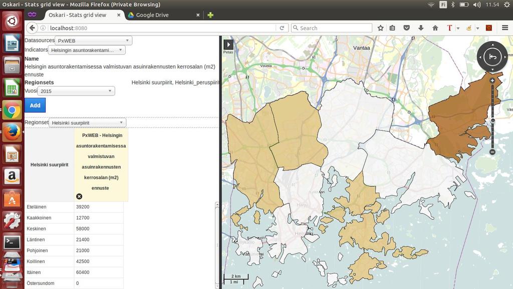
6 Implementation of Case Study PXWeb Helsinki on Oskari
7 Data source: PxWeb API (Statistical API) A programmatic way to access Px Web database. -Get request for metadata and tables - Post request for querying with parameters Data available from different organizations over the world.
8 Development Platform - Oskari Oskari is a tool : for building multipurpose web mapping applications benefitting distributed Spatial Data Infrastructures For creating Embedded map clients onto other websites very efficiently For setting up Geoportals or Web GIS systems For setting up advanced web-based tools, such as decision making support services and data analysis tools Multilingual English & Finnish full coverage, 15 other languages with partial coverage Open source (MIT & EUPL) source: NLS

9 Source: NLS
10 Pros and Cons Pros: Most popular web platform for professionals, decision makers and any other people interested with spatial data especially in Finland. Many organizations adapted their own version ( It is easy to have complete application by following guidelines. Start by forking and follow documentation. Any PxWeb statistical data source can be integrated now Cons: It is not so easy to develop new functionalities. Thematic maps were under construction.
11 Solutions for Problems -Backend development: Server side plugin (request and transformation) had to be created for data integration that use server side mashup technique -Frontend development: Creating bundles(functionality containers) to provide a functionality for an application. This bundle use data visualization library to show data in suitable graphs. -Use design principles for multiple view system and visualization seeking mantra
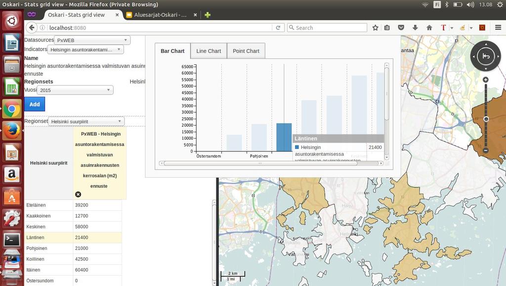
12 Results of Visualization Indicators, Filters, Regions and Comparison

13
14

15
16
17
18
19
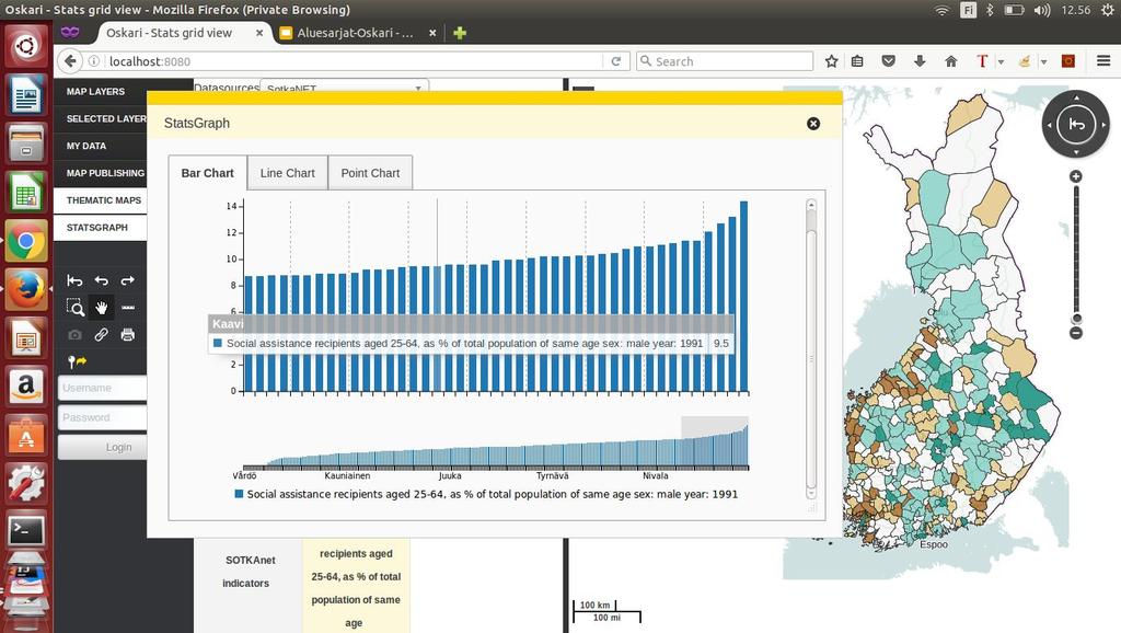
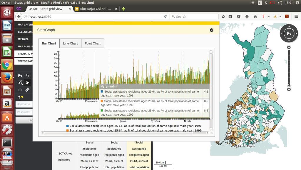
20 Graphs and Thematic Maps Bar, Line, Point Graphs and Different regions

21

22
23

24
25
26 Visual-Seeking Mantra with Multiple Views Overview Zoom and Filter Details on demand View Relationships + Highlight Sort
27 Overview and Sorted values

28
29

30
31 Zoom and Filter

32

33
34 Details on Demand
35

36
37 View Relationships

38
39

40

41
42 Highlight on Click
43
44
45
46

47
48 Conclusion Data is meaningless if it doesn t bring information, knowledge or wisdom with help of tools and processes. GIS community has the chance to harness the sources of data from the web with visualization and analysis to enlighten people and decision makers. Geospatial service integration platform can be improved by implementing correctly designed statistical exploration tools with open statistical APIs. Using mashup techniques and understanding technologies and design principles can ease to implement statistical exploration tools.

49
From Geoportal to Spatial Data Service Platform. Jani Kylmäaho National Land Survey of Finland Development Centre
 From Geoportal to Spatial Data Service Platform Jani Kylmäaho National Land Survey of Finland Development Centre Introduction National Land Survey of Finland - 1900 employees Development Centre - 120 employees
Initial Operating Capability & The INSPIRE Community Geoportal
 INSPIRE Conference, Rotterdam, 15 19 June 2009 1 Infrastructure for Spatial Information in the European Community Initial Operating Capability & The INSPIRE Community Geoportal EC INSPIRE GEOPORTAL TEAM
INSPIRE Spatial Data on the Web building a user-friendly webby SDI
 INSPIRE Spatial Data on the Web building a user-friendly webby SDI Linda van den Brink & Friso Penninga (presented by Rob van de Velde) Geonovum Agenda Objective of this presentation: Apply insights from
The European Location Framework (ELF) Project One Source for Reference Geo Information for Europe
 Project One Source for Reference Geo Information for Europe") The European Location Framework (ELF) Project One Source for Reference Geo Information for Europe Presentation to: By: Date: ICC Dresden Antti Jakobsson, Technical Coordinator 28 th August 2013 The ELF
The European Location Framework (ELF) Project One Source for Reference Geo Information for Europe Presentation to: By: Date: ICC Dresden Antti Jakobsson, Technical Coordinator 28 th August 2013 The ELF
INSPIRE: The ESRI Vision. Tina Hahn, GIS Consultant, ESRI(UK) Miguel Paredes, GIS Consultant, ESRI(UK)
 Miguel Paredes, GIS Consultant, ESRI(UK)") INSPIRE: The ESRI Vision Tina Hahn, GIS Consultant, ESRI(UK) Miguel Paredes, GIS Consultant, ESRI(UK) Overview Who are we? Introduction to ESRI Inc. and ESRI(UK) Presenters ArcGIS The ESRI Solution to
INSPIRE: The ESRI Vision Tina Hahn, GIS Consultant, ESRI(UK) Miguel Paredes, GIS Consultant, ESRI(UK) Overview Who are we? Introduction to ESRI Inc. and ESRI(UK) Presenters ArcGIS The ESRI Solution to
Introduction to INSPIRE. Network Services
 Introduction to INSPIRE. Network Services European Commission Joint Research Centre Institute for Environment and Sustainability Digital Earth and Reference Data Unit www.jrc.ec.europa.eu Serving society
Providing Interoperability Using the Open GeoServices REST Specification
 2013 Esri International User Conference July 8 12, 2013 San Diego, California Technical Workshop Providing Interoperability Using the Open GeoServices REST Specification Satish Sankaran Kevin Sigwart What
GeoPortal best practise
 Workshop on Geospatial Data Infrastructure for Economic Development ETT 53097 GeoPortal best practise Tomaž Petek AGENDA Why geoportal Architecture of geoportals Some examples of best practise Example
OSGeo Web Mapping Typification: GeoMajas, Mapbender, MapFish and OpenLayers. Christoph Baudson Arnulf Christl FOSS4G 2010 Barcelona
 OSGeo Web Mapping Typification: GeoMajas, Mapbender, MapFish and OpenLayers Christoph Baudson Arnulf Christl FOSS4G 2010 Barcelona Disclaimer All information contained in this presentation has been compiled
GEOSPATIAL ERDAS APOLLO. Your Geospatial Business System for Managing and Serving Information
 GEOSPATIAL ERDAS APOLLO Your Geospatial Business System for Managing and Serving Information ERDAS APOLLO Do you have large volumes of data, a geographicallydistributed user base and rapidly changing
Enterprise Geographic Information Servers. Dr David Maguire Director of Products Kevin Daugherty ESRI
 Enterprise Geographic Information Servers Dr David Maguire Director of Products Kevin Daugherty ESRI Outline Introduction Enterprise GIS vs. Spatially-enabled IS Architectures for building Enterprise GIS
DATA SHARING AND DISCOVERY WITH ARCGIS SERVER GEOPORTAL EXTENSION. Clive Reece, Ph.D. ESRI Geoportal/SDI Solutions Team
 DATA SHARING AND DISCOVERY WITH ARCGIS SERVER GEOPORTAL EXTENSION Clive Reece, Ph.D. ESRI Geoportal/SDI Solutions Team Geoportal Extension for ArcGIS Server Context within an Enterprise Spatial Data Infrastructure
How to Report on Data Quality in a Multinational Environment?
 How to Report on Data Quality in a Multinational Environment? Presentation to: By: Date: SDMQ2015 Anja Hopfstock, BKG 20.01.2015 Agenda ELF architecture Data Quality Management Data Quality Reporting Summary
Using ArcGIS for Server. Javier Abadía, Esri España Peter McDaid, Esri UK
 Using ArcGIS for Server Javier Abadía, Esri España Peter McDaid, Esri UK 1. Intro 2. ArcGIS for Server = Geospatial Apps Server 3. Map Services Publishing Flow Apps 4. Spatial Functionality Services Publishing
Spatial Data on the Web
 Spatial Data on the Web Tools and guidance for data providers The European Commission s science and knowledge service W3C Data on the Web Best Practices 35 W3C/OGC Spatial Data on the Web Best Practices
Validating services and data in an SDI
 Validating services and data in an SDI Presentation to: By: Date: INSPIRE Conference Clemens Portele, Jon Herrmann, Roy Mellum 30 September 2016 4 October, 2016 ELF is the response from the European Mapping
INSPIRE trenutni status i buduće aktivnosti
 INSPIRE trenutni status i buduće aktivnosti Vlado Cetl Dani IPP 2017, Zagreb, Hrvatska Joint Research Centre The European Commission s science and knowledge service What is INSPIRE? 7.500 data providers
Discovery and Access of Geospatial Resources Using GIS Portal Toolkit Marten Hogeweg Product Manager GIS Portal Toolkit
 Discovery and Access of Geospatial Resources Using GIS Portal Toolkit Marten Hogeweg Product Manager GIS Portal Toolkit Outline Elements of Spatial Data Infrastructures Current trends Position of GIS portals
Understanding and Using Metadata in ArcGIS. Adam Martin Marten Hogeweg Aleta Vienneau
 Understanding and Using Metadata in ArcGIS Adam Martin Marten Hogeweg Aleta Vienneau Adam Martin National Government Account Management R&D Open Data Marten Hogeweg National Government Professional Services
Infrastructure for Spatial Information in Europe. Proposed action for update of MIWP: Alternative encodings for INSPIRE data
 INSPIRE Infrastructure for Spatial Information in Europe Proposed action for update of MIWP: Alternative encodings for INSPIRE data Type Creator MIWP Action fiche DG ENV Date/status/version 20/11/2017
Metadata Topic Harmonization and Semantic Search for Linked-Data-Driven Geoportals -- A Case Study Using ArcGIS Online
 Metadata Topic Harmonization and Semantic Search for Linked-Data-Driven Geoportals -- A Case Study Using ArcGIS Online Yingjie Hu 1, Krzysztof Janowicz 1, Sathya Prasad 2, and Song Gao 1 1 STKO Lab, Department
Webservice-energy.org GEO Community Portal & Spatial Data Infrastructure for Energy
 Webservice-energy.org GEO Community Portal & Spatial Data Infrastructure for Energy Lionel Menard / Oct. 23 2017 Centre Observation, Impacts, Energy Research activities: Use of Earth observation data (Models,
Validation experience
 Validation experience Paloma Abad Head of SDI Department SDI Workshop 26-06-2018 INSPIRE KEN INSPIRE KEN, june 2018 1 Points 1. Introduction 2. Interoperability 3. Geoportal Thematic Viewer 4. Conclusions
ECLIPSE PERSISTENCE PLATFORM (ECLIPSELINK) FAQ
 FAQ") ECLIPSE PERSISTENCE PLATFORM (ECLIPSELINK) FAQ 1. What is Oracle proposing in EclipseLink, the Eclipse Persistence Platform Project? Oracle is proposing the creation of the Eclipse Persistence Platform
ECLIPSE PERSISTENCE PLATFORM (ECLIPSELINK) FAQ 1. What is Oracle proposing in EclipseLink, the Eclipse Persistence Platform Project? Oracle is proposing the creation of the Eclipse Persistence Platform
GEOSPATIAL ENGINEERING COMPETENCIES. Geographic Information Science
 GEOSPATIAL ENGINEERING COMPETENCIES Geographic Information Science The character and structure of spatial information, its methods of capture, organisation, classification, qualification, analysis, management,
Volunteered Geographic Information
 Volunteered Geographic Information A characterization Watse Castelein wcastelein@topografia.upm.es Łukasz Grus, Joep Crompvoets, Arnold Bregt Wageningen, 16 april 2010 Workshop: Voluntary geographic information
Esri and MarkLogic: Location Analytics, Multi-Model Data
 Esri and MarkLogic: Location Analytics, Multi-Model Data Ben Conklin, Industry Manager, Defense, Intel and National Security, Esri Anthony Roach, Product Manager, MarkLogic James Kerr, Technical Director,
GeoNetwork: metadata and cataloging French (GeoSource) and Swiss (geocat.ch) experiences
 and Swiss (geocat.ch) experiences") GeoNetwork: metadata and cataloging French (GeoSource) and Swiss (geocat.ch) experiences camptocamp SA / 12. mars 2009 / www.camptocamp.com / info@camptocamp.com Camptocamp, a Franco-Swiss company A Franco-Swiss
GeoNetwork: metadata and cataloging French (GeoSource) and Swiss (geocat.ch) experiences camptocamp SA / 12. mars 2009 / www.camptocamp.com / info@camptocamp.com Camptocamp, a Franco-Swiss company A Franco-Swiss
From the INSPIRE Engine Room
 From the INSPIRE Engine Room Michael Lutz ENiiG Conference, Lisbon 9 November 2016 Joint Research Centre the European Commission's in-house science service The JRC's role in INSPIRE Support MS in implementation
INSPIRE Geoportal Rich user experience across member states services
 INSPIRE Geoportal Rich user experience across member states services developed under a contract with the EC (JRC) Diomede ILLUZZI 1 Nicola LUNANOVA 1 Torsten FRIEBE 2 1 Planetek Italia s.r.l Via Masaua
INSPIRE Download Service
 The OGC SOS as INSPIRE Download Service for (meteorological) l) Observation Data Simon Jirka (52 North) 29 th October 2014 5th Workshop on the use of GIS/OGC standards in meteorology Offenbach (Germany)
National Geographic Institute
 National Geographic Institute National Center for Geographic Information A specific website for metadata in Spain: MD Geoportal Alejandra Sánchez Maganto A.F.Rodríguez, P. Abad, E. López, M. Juanatey,
Achieving Interoperability Using Open Standards
 FedGIS Conference February 24 25, 2016 Washington, DC Achieving Interoperability Using Open Standards Satish Sankaran Marten Hogeweg Agenda Understanding Interoperability What, Why and How? ArcGIS Platform
Data Acquisition using Mashup and 3-D Technology. Matt Rahr College of Agriculture and Life Sciences University of Arizona
 Data Acquisition using Mashup and 3-D Technology Matt Rahr College of Agriculture and Life Sciences University of Arizona Let s Do It! What is a Mashup? + Your Data A hybrid website or web application
Web Services for Geospatial Mobile AR
 Web Services for Geospatial Mobile AR Introduction Christine Perey PEREY Research & Consulting cperey@perey.com Many popular mobile applications already use the smartphone s built-in sensors and receivers
SDI SOLUTIONS FOR INSPIRE: TECHNOLOGIES SUPPORTING A FRAMEWORK OF COOPERATION
 SDI SOLUTIONS FOR INSPIRE: TECHNOLOGIES SUPPORTING A FRAMEWORK OF COOPERATION Roberto Lucchi 1, Marten Hogeweg 1, Guenther Pichler 2 1 Esri, Redlands, CA, USA 2 Esri Kranzberg, Germany 1 Vision INSPIRE
INSPIRE and Open Data Recent Developments and Best Practices
 INSPIRE and Open Data Recent Developments and Best Practices These documents are only complete, when used in connection with the verbal paper; any isolated use may lead to misunderstandings. Michael Müller
INTERNATIONAL JOURNAL OF ADVANCED RESEARCH IN ENGINEERING AND TECHNOLOGY (IJARET) MASHUP AS A FUTURE OF GEO-PORTAL
 MASHUP AS A FUTURE OF GEO-PORTAL") INTERNATIONAL JOURNAL OF ADVANCED RESEARCH IN ENGINEERING AND TECHNOLOGY (IJARET) International Journal of Advanced Research in Engineering and Technology (IJARET), ISSN ISSN 0976-6480 (Print) ISSN 0976-6499
INTERNATIONAL JOURNAL OF ADVANCED RESEARCH IN ENGINEERING AND TECHNOLOGY (IJARET) International Journal of Advanced Research in Engineering and Technology (IJARET), ISSN ISSN 0976-6480 (Print) ISSN 0976-6499
This document is a preview generated by EVS
 TECHNICAL REPORT RAPPORT TECHNIQUE TECHNISCHER BERICHT CEN/TR 15449-5 April 2015 ICS 07.040; 35.240.70 English Version Geographic information - Spatial data infrastructures - Part 5: Validation and testing
Extending ArcGIS Maps for SharePoint. Quan Tang Scott Ball
 Extending ArcGIS Maps for SharePoint Quan Tang Scott Ball Agenda Extending ArcGIS Maps for SharePoint ArcGIS platform overview ArcGIS + SharePoint = Better together ArcGIS Maps for SharePoint overview
Working with Feature Layers. Russell Brennan Gary MacDougall
 Working with Feature Layers Russell Brennan Gary MacDougall Working with Feature Layers Session will focus on feature access and editing Highlight new features added over the last few releases Agenda Introduction
Semantic Web Company. PoolParty - Server. PoolParty - Technical White Paper.
 Semantic Web Company PoolParty - Server PoolParty - Technical White Paper http://www.poolparty.biz Table of Contents Introduction... 3 PoolParty Technical Overview... 3 PoolParty Components Overview...
Working with the ArcGIS Viewer for Flex Application Builder
 Working with the ArcGIS Viewer for Flex Application Builder Esri Canada User Conference St. John s November 15, 2012 Presented By: Greg Yetman gyetman@esri.ca Agenda This seminar is designed to help you
Standards, standardisation & INSPIRE Status, issues, opportunities
 Standards, standardisation & INSPIRE Status, issues, opportunities INSPIRE Coordination Team 6 th MIG meeting, 13-14 June 2017 Joint Research Centre The European Commission's science and knowledge service
ELF- joining Europe together
 ELF- joining Europe together An open standard based multinational web mapping project, building on INSPIRE Presentation to: ISO/TC211 Standards in Action Workshop By: Date: Jari Reini 10 th June 2015 19
Creating an Exceptional Web Experience. Land and Property Management Authority
 Creating an Exceptional Web Experience Land and Property Management Authority SDI = Spatial Data Infrastructure 2 Tranches Web 2.0 Web platform Browser + RIA Observable Trends More people online 1.7
Interoperability and Standards Supports in ArcGIS
 Esri International User Conference San Diego, California Technical Workshops July 26, 2012 Interoperability and Standards Supports in ArcGIS Satish Sankaran, Esri Yingqi Tang, Esri Agenda Esri s participation
Spatial Data on the Web
 Spatial Data on the Web Tools and guidance for data providers Clemens Portele, Andreas Zahnen, Michael Lutz, Alexander Kotsev The European Commission s science and knowledge service Joint Research Centre
EarthLookCZ as Czech way to GMES
 EarthLookCZ as Czech way to GMES Karel Charvat 1 and Petr Horak 1 1 WirelessInfo, Czech Republic, charvat@wirelessinfo.cz Abstract Global Monitoring for Environment and Security is one of 4 ranges of solutions
Oracle Spatial Pure Web Editing for Telco Outside Plant Engineering Planning. Eamon Walsh espatial Solutions
 Spatial SIG Oracle Spatial Pure Web Editing for Telco Outside Plant Engineering Planning Eamon Walsh espatial Solutions Speaker Eamon Walsh, CTO espatial Solutions. over 20 years experience in the IT industry,
Geospatial Management Office (GMO) U.S. DEPARTMENT OF HOMELAND SECURITY OFFICE OF THE CHIEF INFORMATION OFFICER (OCIO)
 U.S. DEPARTMENT OF HOMELAND SECURITY OFFICE OF THE CHIEF INFORMATION OFFICER (OCIO)") Geospatial Management Office (GMO) U.S. DEPARTMENT OF HOMELAND SECURITY OFFICE OF THE CHIEF INFORMATION OFFICER (OCIO) 1 Agenda What We (GMO) Do Core Offerings Geospatial Information Infrastructure (GII)
Geospatial Management Office (GMO) U.S. DEPARTMENT OF HOMELAND SECURITY OFFICE OF THE CHIEF INFORMATION OFFICER (OCIO) 1 Agenda What We (GMO) Do Core Offerings Geospatial Information Infrastructure (GII)
ArcGIS Enterprise: Architecture & Deployment. Anthony Myers
 ArcGIS Enterprise: Architecture & Deployment Anthony Myers 1 2 3 4 5 Web GIS Overview of ArcGIS Enterprise Federation & Hosted Server Deployment Patterns Implementation 1 Web GIS ArcGIS Enabling GIS for
3D in the ArcGIS Platform. Chris Andrews
 3D in the ArcGIS Platform Chris Andrews Geospatial 3D is already all around us 3D is expanding the GIS community s opportunity to provide value 3D City & Infrastructure Models Generated 3D features Photogrammetrc
HUMBOLDT Application Scenario: Protected Areas
 CC by Erlend Schei Copyright by Kecko Copyright by Michael Bezzina CC by Gunnar Ries Copyright by Michael Bezzina Copyright by Michael Bezzina Copyright by Michael Bezzina CC by fs999 CC by Jordan Nielsen
MapInfo Technology Update. Håkan Karlsson Systems Engineer Nordic & Baltic Region
 MapInfo Technology Update Håkan Karlsson Systems Engineer Nordic & Baltic Region Agenda Software product overview - Applications - Developer Platforms New.NET Platform - MapXtreme 2004 - Future direction
The Geographic Names Register of the National Land Survey of Finland
 7 June 2002 English only Eighth United Nations Conference on the Standardization of Geographical Names Berlin, 27 August-5 September 2002 Item 12 (d) of the provisional agenda * Toponymic data files: automated
The importance of standards bodies in EU funded projects
 The importance of standards bodies in EU funded projects INSPIRE Conference, 27. June 01. July 2011 Geospatial SDI Workshop Arnulf Christl (metaspatial) and Athina Trakas () Athina Trakas Open Geospatial
Marine and Coastal Data Services in the Cloud. Richard Rombouts - Snowflake Software Ltd. & Keiran Millard SeaZone Solutions Ltd.
 Marine and Coastal Data Services in the Cloud Richard Rombouts - Snowflake Software Ltd. & Keiran Millard SeaZone Solutions Ltd. Marine Geospatial Data Inspired Marine Data? SeaZone HydroSpatial Global
Click to add text IBM Collaboration Solutions
 IBM Connections Search: Troubleshooting and Best Practices 5/14/2014 Greg Presayzen Client Technical Professional Mark McCarville Advisory Software Engineer Click to add text IBM Collaboration Solutions
Toward Horizon 2020: INSPIRE, PSI and other EU policies on data sharing and standardization
 Toward Horizon 2020: INSPIRE, PSI and other EU policies on data sharing and standardization www.jrc.ec.europa.eu Serving society Stimulating innovation Supporting legislation The Mission of the Joint Research
Web Map Servers. Mark de Blois. Septembre 2016
 Web Map Servers Mark de Blois Septembre 2016 Learning Objectives After this lecture you will be able to understand web map servers as used in Web-GIS applications Introduction A Web Map Server is a computer
INSPIRE and Service Level Management Why it matters and how to implement it
 Service Level Agreements for D-Grid INSPIRE and Service Level Management Why it matters and how to implement it Bastian Baranski con terra GmbH Münster, Germany http://www.sla4d-grid.de Motivation Evolution
What s s Coming in ArcGIS 10 Desktop
 What s s Coming in ArcGIS 10 Desktop Damian Spangrud ArcGIS Product Manager, ESRI dspangrud@esri.com (or at least turn to silent) ArcGIS 10 A Simple & Pervasive System for Using Maps & Geographic Information
INSPIRE Conference Automatic metadata generation for the Web geo-resources
 INSPIRE Conference 2011 Automatic metadata generation for the Web geo-resources B. Borjas, A.J. Florczyk, F.J. López-Pellicer, J. Nogueras-Iso, F.J. Zarazaga-Soria June 28, 2011. Edinburgh Advanced Information
Benefits of CORDA platform features
 Benefits of CORDA platform features Functionalities, main tools and the benefits of using CORDA platform Copernicus service providers (land monitoring and emergency services) require reference data for
The EOC Geoservice: Standardized Access to Earth Observation Data Sets and Value Added Products ABSTRACT
 The EOC Geoservice: Standardized Access to Earth Observation Data Sets and Value Added Products K. Dengler, T. Heinen, A. Huber, K. Molch, E. Mikusch German Aerospace Center (DLR) German Remote Sensing
Implementing Quality in SDIs Introducing Building Blocks of Quality Web Services
 Implementing Quality in SDIs Introducing Building Blocks of Quality Web Services Antti Jakobsson J. Mäkelä, R. Henriksson,J. Marttinen,L. Tsoulos, I.Kavadas, E. Onstein, M. Beare,F. Williams, J. Walsh,
Implementing GeoDRM support in an OpenLayers based viewer Access to the French geoportal WMS-C services from the Spanish SDI
 INSPIRE Conference 2011 Implementing GeoDRM support in an OpenLayers based viewer Access to the French geoportal WMS-C services from the Spanish SDI R. Béjar, M. Á. Latre, J. Valiño, F. Javier Zarazaga-Soria,
INSPIRE overview and possible applications for IED and E-PRTR e- Reporting Alexander Kotsev
 INSPIRE overview and possible applications for IED and E-PRTR e- Reporting Alexander Kotsev www.jrc.ec.europa.eu Serving society Stimulating innovation Supporting legislation The European data puzzle 24
Achieving Interoperability using the ArcGIS Platform. Satish Sankaran Roberto Lucchi
 Achieving Interoperability using the ArcGIS Platform Satish Sankaran Roberto Lucchi Thank you Please fill out the session survey in your mobile app Select [Achieving Interoperability using the ArcGIS Platform]
ELFI: A European Location Framework
 1 ELFI: A European Location Framework 1. Our Ambition Project ELFI will foster the wider use of geo-information and enable the creation of innovative valueadded services. 2. Our Objectives We aim to create
Leveraging OGC Services in ArcGIS Server. Satish Sankaran Yingqi Tang
 Leveraging OGC Services in ArcGIS Server Satish Sankaran ssankaran@esri.com Yingqi Tang ytang@esri.com Agenda Interoperability Enablers OGC and esri OGC Web Services ArcGIS and OGC Web Services - @ version
GENeric European Sustainable Information Space for Environment.
 GENeric European Sustainable Information Space for Environment http://www.genesis-fp7.eu/ Outline Introduction The GENESIS FP7 project The GENESIS solution s architecture GENESIS experience with INSPIRE
Advanced Search for Magento 2
 Last update: 2018/01/30 16:37 magento_2:advanced_search https://amasty.com/docs/doku.php?id=magento_2:advanced_search For more details see the Advanced Search for Magento 2 extension page. Advanced Search
Adobe Experience Manager (AEM) Translation Connector Quick Start Guide v1.0.0
 Translation Connector Quick Start Guide v1.0.0") Adobe Experience Manager (AEM) Translation Connector Quick Start Guide v1.0.0 Contents About Acclaro 2 Acclaro AEM Translation Connector Overview 2 Legal Terms and User Agreement 2 Site Backup and Staging
Adobe Experience Manager (AEM) Translation Connector Quick Start Guide v1.0.0 Contents About Acclaro 2 Acclaro AEM Translation Connector Overview 2 Legal Terms and User Agreement 2 Site Backup and Staging
SMARTERDECISIONS. Geospatial Portal 2013 Open Interoperable GIS/Imagery Services with ERDAS Apollo 2013 and ERDAS Imagine 2013
 Geospatial Portal 2013 Open Interoperable GIS/Imagery Services with ERDAS Apollo 2013 and ERDAS Imagine 2013 Carahsoft Intergraph Government Solutions SMARTERDECISIONS Geospatial Portal 2013 Geospatial
Testing - an essential aspect of establishing an SDI
 Testing - an essential aspect of establishing an SDI Clemens Portele, Anders Östman, Michael Koutroumpas, Xin He, Janne Kovanen, Markus Schneider, Andriani Skopeliti INSPIRE Conference 2011 30 June 2011
Carmenta Server Product Description
 White paper Carmenta Server Product Description Carmenta AB, Tel +46-31-775 57 00, www.carmenta.com P315 121RD, 2010 Carmenta reserves the right to change the specifications at any time and without notice.
Outline. The Collaborative Research Platform for Data Curation and Repositories: CKAN For ANGIS Data Portal. Open Access & Open Data.
 Outline The Collaborative Research Platform for Data Curation and Repositories: CKAN For ANGIS Data Portal Open Access & Open Data ANGIS data portal New developed features Future works Hsiung-Ming Liao,
METAINFORMATION INFRASTRUCTURE FOR GEOSPATIAL INFORMATION
 2010/2 PAGES 1 7 RECEIVED 15. 6. 2009 ACCEPTED 2. 3. 2010 T. KLIMENT METAINFORMATION INFRASTRUCTURE FOR GEOSPATIAL INFORMATION ABSTRACT Tomáš KLIMENT email: tomas.kliment@stuba.sk Research field: Spatial
Using the OGC SOS as INSPIRE Download Service for Observation Data
 Using the OGC SOS as INSPIRE Download Service for Observation Data Simon Jirka (52 North) Alexander Kotsev (JRC) Michael Lutz (JRC) Matthes Rieke (52 North) Robin Smith (JRC) Paul Smits (JRC) 18 th June
PDOK. Part of the Dutch SDI, growing from portal to platform. Haico van der Vegt Strategic Advisor Kadaster
 PDOK Part of the Dutch SDI, growing from portal to platform Haico van der Vegt Strategic Advisor Kadaster PDOK public services on the map Geo-webservices distribution portal E-Government initiative Open,
A Framework of Information Technology for Water Resources Management
 A Framework of Information Technology for Water Resources Management P.S.V.S. Sridhar T. N. Jowhar Wadia Institute of Himalyan Geology, Anant Bhaskar Garg U. Kedareswarudu ABSTRACT The use of the information
SAFER the GIGAS Effect
 SAFER the GIGAS Effect How INSPIRE, GMES and GEOSS are influencing EC projects Arnaud Cauchy 23/06/2010 Agenda GIGAS Project Summary SAFER Project Summary SAFER Original Approach GIGAS Influences SAFER
Huerfano County GIS Portal User Guide
 Huerfano County GIS Portal User Guide Table of Contents What is a geoportal? 1 Using Huerfano County GIS portal 1 Navigating the map builder 5 Working with Layers 6 Using the Query Tool 7 Printing Maps
Microsoft Power BI for O365
 Microsoft Power BI for O365 Next hour.. o o o o o o o o Power BI for O365 Data Discovery Data Analysis Data Visualization & Power Maps Natural Language Search (Q&A) Power BI Site Data Management Self Service
Leveraging OGC Services in ArcGIS Server. Satish Sankaran, Esri Yingqi Tang, Esri
 Leveraging OGC Services in ArcGIS Server Satish Sankaran, Esri Yingqi Tang, Esri GIS Creating and Managing Geo Information Products - Proprietary - Open Specifications - Standards Dissemination of Geo
For each use case, the business need, usage scenario and derived requirements are stated. 1.1 USE CASE 1: EXPLORE AND SEARCH FOR SEMANTIC ASSESTS
 1 1. USE CASES For each use case, the business need, usage scenario and derived requirements are stated. 1.1 USE CASE 1: EXPLORE AND SEARCH FOR SEMANTIC ASSESTS Business need: Users need to be able to
Agricultural bibliographic data sharing & interoperability in China
 Agricultural bibliographic data sharing & interoperability in China Prof. Xuefu Zhang,Xian Guojian and Sun Wei Agricultural Information Institute of CAAS Asia Pacific Advanced Network Meeting, 29 Aug.,
Understanding ArcGIS Online - why organizations should embrace the cloud now
 Understanding ArcGIS Online - why organizations should embrace the cloud now Presented to: GeoAlberta - workshop Presented by: David Parry September 25, 2013 Today s Agenda Introduction - Why the Cloud?
Guidelines for the encoding of spatial data
 INSPIRE Infrastructure for Spatial Information in Europe Guidelines for the encoding of spatial data Title Status Creator Date 2012-06-15 Subject Publisher Type Description Contributor Format Source Rights
INSPIRE status report
 INSPIRE Team INSPIRE Status report 29/10/2010 Page 1 of 7 INSPIRE status report Table of contents 1 INTRODUCTION... 1 2 INSPIRE STATUS... 2 2.1 BACKGROUND AND RATIONAL... 2 2.2 STAKEHOLDER PARTICIPATION...
Abu Dhabi e Government Strategy and ICT Standardization. Abu Dhabi, November 2014
 0 Abu Dhabi e Government Strategy and ICT Standardization Abu Dhabi, November 2014 The Abu Dhabi e-government vision is driven by 4 strategic themes towards modernizing the Government services in the Emirate
Introduction to Autodesk MapGuide EnterpriseChapter1:
 Chapter 1 Introduction to Autodesk MapGuide EnterpriseChapter1: In this chapter, you review the high-level key components that comprise Autodesk MapGuide Enterprise. The Autodesk MapGuide Studio, an integral
Towards Linked Data and ontology development for the semantic enrichment of volunteered geo-information
 AGILE Link-VGI workshop, Helsinki 14 June 2016 Towards Linked Data and ontology development for the semantic enrichment of volunteered geo-information Rob Lemmens University of Twente, Faculty of Geo-Information
Developing Cross-Platform Native Apps with AppStudio for ArcGIS. Jo Fraley Erwin Soekianto
 Developing Cross-Platform Native Apps with AppStudio for ArcGIS Jo Fraley Erwin Soekianto AppStudio for ArcGIS ios Android Linux 1App Windows Mac What is AppStudio for ArcGIS? A suite of productivity tools
Mike Horsfall Technical Manager GeoSpatial Sales
 An Introduction to Bentley Utilities Designer Mike Horsfall Technical Manager GeoSpatial Sales What is Bentley Utilities Designer? Bentley Utilities Designer is: A multi-utilities desktop GIS Built on
SQL, Scaling, and What s Unique About PostgreSQL
 SQL, Scaling, and What s Unique About PostgreSQL Ozgun Erdogan Citus Data XLDB May 2018 Punch Line 1. What is unique about PostgreSQL? The extension APIs 2. PostgreSQL extensions are a game changer for
REPORT OF THE WORKING GROUP 2: REGIONAL FUNDAMENTAL DATA
 UNITED NATIONS E/CONF.97/3/Add.2 ECONOMIC AND SOCIAL COUNCIL Seventeenth United Nations Regional Cartographic Conference for Asia and the Pacific Bangkok, 18-22 September 2006 Item 5 of the provisional
Getting Started with ArcGIS for Server. Charmel Menzel and Ken Gorton
 Getting Started with ArcGIS for Server Charmel Menzel and Ken Gorton Agenda What is ArcGIS for Server? Types of Web services Publishing resources onto the Web Clients to ArcGIS for Server Editions and