3D Imaging of Fossils Using Close-Range Photogrammetry
|
|
|
- Rosa Chapman
- 5 years ago
- Views:
Transcription

1 3D Imaging of Fossils Using Close-Range Photogrammetry Daniel J. Miller The University of Michigan Museum of Paleontology idigbio Workshop Specimen Imaging for Paleontology Austin Texas, April 29, 2014
2 3D Reconstructions Potential Applications Virtual Collections especially useful for Type and rare/fragile material Teaching & Research Public Education & Outreach Supplemental material to published works Etc.!
3 Criteria for choosing an appropriate digitization system 1 Cost 2 Material of digitization subject 3 Size of digitization subject 4 Portability of equipment 5 Accuracy of the system 6 Texture acquisition 7 Productivity of the technique 8 Skill requirements 9 Compliance of produced data with standards From Pavlidis et al 2007

4 Acquiring 3D data - Methods Laser Scanning Structured light 3D stylus digitizers Photogrammetry & Dense Stereo Matching Visual Hulls CT scans
5 Photogrammetry Photogrammetry involves extracting reliable quantitative information about objects or the environment through the analysis of photographs or related sensors. Almost as old as photography itself. Based on triangulation. Can be used over a range of object dimensions (mountains to microfossils)
6 Photogrammetry
7 Photogrammetry Bundle Adjustment Dense Stereo Matching (Hullo et al. 2007)

8 Photogrammetry Pixel matching & DSM Dense Stereo Matching From Hullo et al. 2007
9 Some Factors to Consider When Starting a Project (not an exhaustive list..) Camera equipment & settings good optics, high resolution sensor, solid construction settings: good manual control, low ISO (less noise),stable white balance; high f-stop (for DOF but not too high or diffraction will degrade image); remote shutter release or timer; record all data. Lighting even lighting, avoid strong shadows or highlights, caution when using flash (use diffusers), Staging Turntable ( lazy Susan, ) or slide table useful. Solid tripod and focusing rail; good overlap and mix of camera angles. Properties of the object Good color texture, good topographic detail helpful. Shiny, crystalline, or other reflective surfaces can cause problems.

10 PhotoModeler Scanner (Miller & Pappas 2010, in prep.)

")
11 (Miller & Pappas 2010, in prep.)

12 Highly textured surface with many small color variations facilitates image matching.
13 3D SOM Can combine visual hulls with basic photogrammetry

14


15
16
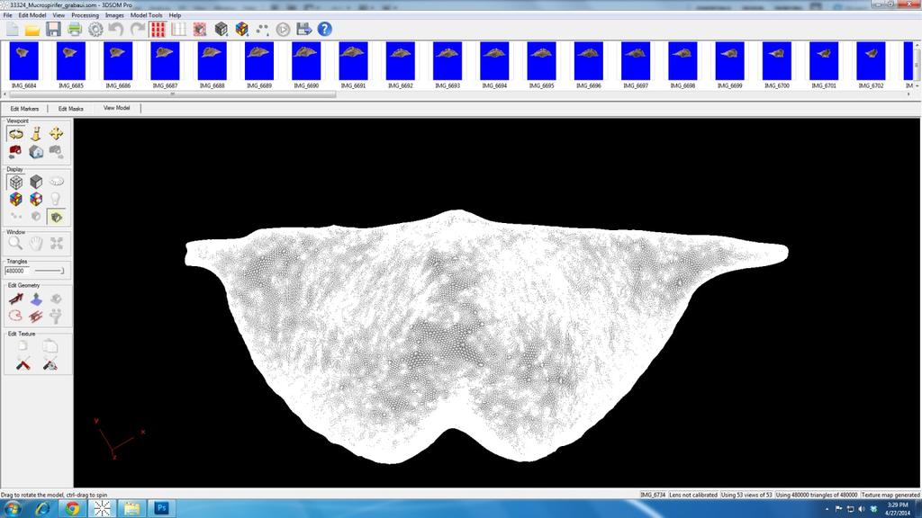
17 33324_Mucrospirifer_grabaui.htm

18 Inaccurate Solutions


19 Errors in Matching Due to Lack of Texture and Color Variation

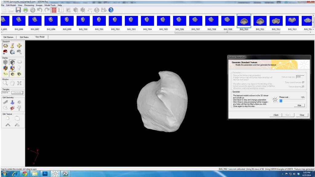

20 31530_Spinocyrtia_mourantae.htm
21 Some Factors to Consider When Starting a Project (not an exhaustive list..) Camera equipment & settings good optics, high resolution sensor, solid construction settings: good manual control, low ISO (less noise),stable white balance; high f-stop (for DOF but not too high or diffraction will degrade image); remote shutter release or timer; record all data. Lighting even lighting, avoid strong shadows or hisghlights, caution when using flash (use diffusers), Staging Turntable ( lazy Susan, ) or slide table useful. Solid tripod and focusing rail; good overlap and mix of camera angles. Properties of the object Good color texture, good topographic detail helpful. Shiny, crystalline, or other reflective surfaces can cause problems.
22 Summary Close-range digital photogrammetry is an attractive option when 3D models and/or 3D coordinate measurements are required. Can be very accurate and can yield dense point clouds. Portable, flexible (same equipment can be used for a broad range of projects). Hardware is relatively inexpensive (camera equipment) compared to some other methods. High-end as well as low-end (cost, performance, difficulty) options are available (Bundler, Python Photogrammetry,123D Catch, etc.).
23 Summary High-quality results require a good understanding of photographic techniques as well as photogrammetric theory, but very useful results are obtainable with little knowledge.. Image matching algorithms can produce large errors under certain conditions. Development of new methods has been rapid and is likely to continue as CPU and GPU capabilities grow.
24 Acknowledgements FUMMP-Friends of the UM Museum of Paleontology: (Software & Camera) University of Michigan Undergraduate Research Opportunities Program (UROP) University of Michigan Museum Studies Program National Science Foundation Adam Baumberg (3DSOM), Janice Pappas (UMMP), Students: Alexander Liberman, Alina Alam, Kelcey Cui (UROP), Zach Bennett, Alexandra Briske, Matthew Meyer, Breezy Mullins, Warren Olivier (MSP), Valerie Syverson (graduate student UMMP)
25
26
Mini Course Archaeological Sciences Interdisciplinary Group University of Minnesota 1
 Mini Course Archaeological Sciences Interdisciplinary Group University of Minnesota 1 Introduction What is photogrammetry, how does it work, what materials does it work on, and how does it compare to other
Other Reconstruction Techniques
 Other Reconstruction Techniques Ruigang Yang CS 684 CS 684 Spring 2004 1 Taxonomy of Range Sensing From Brain Curless, SIGGRAPH 00 Lecture notes CS 684 Spring 2004 2 Taxonomy of Range Scanning (cont.)
Precise laser-based optical 3D measurement of welding seams under water
 Precise laser-based optical 3D measurement of welding seams under water ISPRS/CIPA Workshop Underwater 3D Recording & Modeling" Piano di Sorrento (Napoli), Italy 16. 17. April 2015 Tanja Ekkel (M.Sc.)
ENGN D Photography / Spring 2018 / SYLLABUS
 ENGN 2502 3D Photography / Spring 2018 / SYLLABUS Description of the proposed course Over the last decade digital photography has entered the mainstream with inexpensive, miniaturized cameras routinely
A New Way to 3D Scan. Photo-based Scanning Saves Time and Money. A White Paper by Alan Walford, Eos Systems Inc.
 A New Way to 3D Scan Photo-based Scanning Saves Time and Money A White Paper by Alan Walford, Eos Systems Inc. Introduction Do you need to create dense 3D point clouds and detailed surface models of physical
Structure from Motion: High resolution DEMs at any scale using everyday equipment
 Structure from Motion: High resolution DEMs at any scale using everyday equipment Anders Damsgaard Last revision: May 20, 2014 Outline Photogrammetry Method Examples Summary Photogrammetry using SfM Production
Light Transport CS434. Daniel G. Aliaga Department of Computer Science Purdue University
 Light Transport CS434 Daniel G. Aliaga Department of Computer Science Purdue University Topics Local and Global Illumination Models Helmholtz Reciprocity Dual Photography/Light Transport (in Real-World)
Cultural Heritage. Geometric Recording of Cultural Monuments. Basic Principles of Geometric Recording. Specific requirements
 LOW COST DIGITAL PHOTOGRAMMETRIC TECHNIQUES FOR THE DOCUMENTATION OF CULTURAL HERITAGE Ch. Ioannidis, S. Soile, C. Potsiou Lab. of Photogrammetry School of Rural & Surveying Eng. National Technical University
Multiview Photogrammetry 3D Virtual Geology for everyone
 Multiview Photogrammetry 3D Virtual Geology for everyone A short course Marko Vrabec University of Ljubljana, Department of Geology FIRST: some background info Precarious structural measurements of fractures
EVOLUTION OF POINT CLOUD
 Figure 1: Left and right images of a stereo pair and the disparity map (right) showing the differences of each pixel in the right and left image. (source: https://stackoverflow.com/questions/17607312/difference-between-disparity-map-and-disparity-image-in-stereo-matching)
Calibration of IRS-1C PAN-camera
 Calibration of IRS-1C PAN-camera Karsten Jacobsen Institute for Photogrammetry and Engineering Surveys University of Hannover Germany Tel 0049 511 762 2485 Fax -2483 Email karsten@ipi.uni-hannover.de 1.
Overview of Active Vision Techniques
 SIGGRAPH 99 Course on 3D Photography Overview of Active Vision Techniques Brian Curless University of Washington Overview Introduction Active vision techniques Imaging radar Triangulation Moire Active
CE 59700: LASER SCANNING
 Digital Photogrammetry Research Group Lyles School of Civil Engineering Purdue University, USA Webpage: http://purdue.edu/ce/ Email: ahabib@purdue.edu CE 59700: LASER SCANNING 1 Contact Information Instructor:
GIS Data Collection. This chapter reviews the main methods of GIS data capture and transfer and introduces key practical management issues.
 9 GIS Data Collection OVERVIEW This chapter reviews the main methods of GIS data capture and transfer and introduces key practical management issues. It distinguishes between primary (direct measurement)
Comparing Aerial Photogrammetry and 3D Laser Scanning Methods for Creating 3D Models of Complex Objects
 Comparing Aerial Photogrammetry and 3D Laser Scanning Methods for Creating 3D Models of Complex Objects A Bentley Systems White Paper Cyril Novel Senior Software Engineer, Bentley Systems Renaud Keriven
Comparing Aerial Photogrammetry and 3D Laser Scanning Methods for Creating 3D Models of Complex Objects
 www.bentley.com Comparing Aerial Photogrammetry and 3D Laser Scanning Methods for Creating 3D Models of Complex Objects A Bentley White Paper Cyril Novel Senior Software Engineer, Bentley Systems Renaud
Introduction to photogrammetry (with an underwater flavor)
") Introduction to photogrammetry (with an underwater flavor) NAS - UCY HFF Field school, Cyprus, 2016 Dimitrios Skarlatos, Assistant Professor, Cyprus University of Technology Photogrammetric vision Lab
Introduction to photogrammetry (with an underwater flavor) NAS - UCY HFF Field school, Cyprus, 2016 Dimitrios Skarlatos, Assistant Professor, Cyprus University of Technology Photogrammetric vision Lab
Leica Systems Overview
 RC30 AERIAL CAMERA SYSTEM Leica Systems Overview The Leica RC30 aerial film camera is the culmination of decades of development, started with Wild's first aerial camera in the 1920s. Beautifully engineered
METIS METIS DRS 2000 DCS
 METIS DRS 2000 DCS Specially designed for the Industrial and Decor market, it integrates Metis exclusive DC SynchroLight (Patent protected technology) METIS METIS DC SynchroLight and SuperScan Lighting
3D BUILDINGS MODELLING BASED ON A COMBINATION OF TECHNIQUES AND METHODOLOGIES
 3D BUILDINGS MODELLING BASED ON A COMBINATION OF TECHNIQUES AND METHODOLOGIES Georgeta Pop (Manea), Alexander Bucksch, Ben Gorte Delft Technical University, Department of Earth Observation and Space Systems,
Photogrammetry: A Modern Tool for Crash Scene Mapping
 Photogrammetry: A Modern Tool for Crash Scene Mapping Background A police accident investigator (AI) has many tasks when arriving at a crash scene. The officer s highest priority is public safety; the
3D Modeling of Objects Using Laser Scanning
 1 3D Modeling of Objects Using Laser Scanning D. Jaya Deepu, LPU University, Punjab, India Email: Jaideepudadi@gmail.com Abstract: In the last few decades, constructing accurate three-dimensional models
Optimized Design of 3D Laser Triangulation Systems
 The Scan Principle of 3D Laser Triangulation Triangulation Geometry Example of Setup Z Y X Target as seen from the Camera Sensor Image of Laser Line The Scan Principle of 3D Laser Triangulation Detektion
COMPARISON OF CAMERA CALIBRATION PARAMETERS USING PHOTOMODELER AND AUSTRALIS
 COMPARISON OF CAMERA CALIBRATION PARAMETERS USING PHOTOMODELER AND AUSTRALIS Fazli Abd. Rahman*, Halim Setan*, Albert K.Chong**, Zulkepli Majid* & Anuar Ahmad* *Department of Geomatic Engineering, Faculty
AN AUTOMATIC 3D RECONSTRUCTION METHOD BASED ON MULTI-VIEW STEREO VISION FOR THE MOGAO GROTTOES
 The International Archives of the Photogrammetry, Remote Sensing and Spatial Information Sciences, Volume XL-4/W5, 05 Indoor-Outdoor Seamless Modelling, Mapping and avigation, May 05, Tokyo, Japan A AUTOMATIC
(and what the numbers mean)
") Using Neutral Density Filters (and what the numbers mean) What are ND filters Neutral grey filters that effectively reduce the amount of light entering the lens. On solid ND filters the light-stopping
Using Neutral Density Filters (and what the numbers mean) What are ND filters Neutral grey filters that effectively reduce the amount of light entering the lens. On solid ND filters the light-stopping
CS635 Spring Department of Computer Science Purdue University
 Light Transport CS635 Spring 2010 Daniel G Aliaga Daniel G. Aliaga Department of Computer Science Purdue University Topics Local and GlobalIllumination Models Helmholtz Reciprocity Dual Photography/Light
Merging LiDAR Data with Softcopy Photogrammetry Data
 Merging LiDAR Data with Softcopy Photogrammetry Data Cindy McCallum WisDOT\Bureau of Technical Services Surveying & Mapping Section Photogrammetry Unit Overview Terms and processes Why use data from LiDAR
DENSE 3D POINT CLOUD GENERATION FROM UAV IMAGES FROM IMAGE MATCHING AND GLOBAL OPTIMAZATION
 DENSE 3D POINT CLOUD GENERATION FROM UAV IMAGES FROM IMAGE MATCHING AND GLOBAL OPTIMAZATION S. Rhee a, T. Kim b * a 3DLabs Co. Ltd., 100 Inharo, Namgu, Incheon, Korea ahmkun@3dlabs.co.kr b Dept. of Geoinformatic
Structured light , , Computational Photography Fall 2017, Lecture 27
 Structured light http://graphics.cs.cmu.edu/courses/15-463 15-463, 15-663, 15-862 Computational Photography Fall 2017, Lecture 27 Course announcements Homework 5 has been graded. - Mean: 129. - Median:
Optical Active 3D Scanning. Gianpaolo Palma
 Optical Active 3D Scanning Gianpaolo Palma 3D Scanning Taxonomy SHAPE ACQUISTION CONTACT NO-CONTACT NO DESTRUCTIVE DESTRUCTIVE X-RAY MAGNETIC OPTICAL ACOUSTIC CMM ROBOTIC GANTRY SLICING ACTIVE PASSIVE
CO-REGISTERING AND NORMALIZING STEREO-BASED ELEVATION DATA TO SUPPORT BUILDING DETECTION IN VHR IMAGES
 CO-REGISTERING AND NORMALIZING STEREO-BASED ELEVATION DATA TO SUPPORT BUILDING DETECTION IN VHR IMAGES Alaeldin Suliman, Yun Zhang, Raid Al-Tahir Department of Geodesy and Geomatics Engineering, University
Multiray Photogrammetry and Dense Image. Photogrammetric Week Matching. Dense Image Matching - Application of SGM
 Norbert Haala Institut für Photogrammetrie Multiray Photogrammetry and Dense Image Photogrammetric Week 2011 Matching Dense Image Matching - Application of SGM p q d Base image Match image Parallax image
Visual Imaging in the Electronic Age Assignment #3 Draft Geometry Capture
 Visual Imaging in the Electronic Age Assignment #3 Draft Geometry Capture Assigned: October 5, 2017 Due Date: TBA (October 2017) The above image is of the sculpture by James Mahoney, which was demonstrated
VERSATILE AND EASY-TO-USE 3D LASER SCANNERS
 VERSATILE AND EASY-TO-USE 3D LASER SCANNERS > > A WORLD OF APPLICATIONS Z Corporation, producers of the industry s fastest, easiest-to-use and most versatile 3D scanners, makes 3D scanning ideal for a
Digitization of 3D Objects for Virtual Museum
 Digitization of 3D Objects for Virtual Museum Yi-Ping Hung 1, 2 and Chu-Song Chen 2 1 Department of Computer Science and Information Engineering National Taiwan University, Taipei, Taiwan 2 Institute of
A Comparison Study of 3D Scanners for Diagnosing Deviations in Their Outputs Using Reverse Engineering Technique
 IOSR Journal of Mechanical and Civil Engineering (IOSR-JMCE) e-issn: 2278-1684,p-ISSN: 2320-334X, Volume 14, Issue 3 Ver. I (May. - June. 2017), PP 26-32 www.iosrjournals.org A Comparison Study of 3D Scanners
Improving the 3D Scan Precision of Laser Triangulation
 Improving the 3D Scan Precision of Laser Triangulation The Principle of Laser Triangulation Triangulation Geometry Example Z Y X Image of Target Object Sensor Image of Laser Line 3D Laser Triangulation
Integrating the Generations, FIG Working Week 2008,Stockholm, Sweden June 2008
 H. Murat Yilmaz, Aksaray University,Turkey Omer Mutluoglu, Selçuk University, Turkey Murat Yakar, Selçuk University,Turkey Cutting and filling volume calculation are important issues in many engineering
EVALUATION OF WORLDVIEW-1 STEREO SCENES AND RELATED 3D PRODUCTS
 EVALUATION OF WORLDVIEW-1 STEREO SCENES AND RELATED 3D PRODUCTS Daniela POLI, Kirsten WOLFF, Armin GRUEN Swiss Federal Institute of Technology Institute of Geodesy and Photogrammetry Wolfgang-Pauli-Strasse
Contour LS-K Optical Surface Profiler
 Contour LS-K Optical Surface Profiler LightSpeed Focus Variation Provides High-Speed Metrology without Compromise Innovation with Integrity Optical & Stylus Metrology Deeper Understanding More Quickly
The Most User-Friendly 3D scanner
 The Most User-Friendly 3D scanner The Solutionix C500 is optimized for scanning small- to medium-sized objects. With dual 5.0MP cameras, the C500 provides excellent data quality at a high resolution. In
Digital Preservation of the Aurelius Church and the Hirsau Museum Complex by Means of HDS and Photogrammetric Texture Mapping
 Master Thesis Ruxandra MOROSAN Ruxandra MOROSAN Digital Preservation of the Aurelius Church and the Hirsau Museum Complex by Means of HDS and Photogrammetric Texture Mapping Duration of the Thesis: 6 months
VZ series Camera Calibration
 VZ series Camera Calibration Calibration Field Setup Place 30 5cm flat reflector targets 1 foot apart on three columns. Place 10 targets on each column vertically. The columns should be approximately 10
Generating 3D Meshes from Range Data
 Princeton University COS598B Lectures on 3D Modeling Generating 3D Meshes from Range Data Robert Kalnins Robert Osada Overview Range Images Optical Scanners Error sources and solutions Range Surfaces Mesh
Bumblebee2 Stereo Vision Camera
 Bumblebee2 Stereo Vision Camera Description We use the Point Grey Bumblebee2 Stereo Vision Camera in this lab section. This stereo camera can capture 648 x 488 video at 48 FPS. 1) Microlenses 2) Status
Photo based Terrain Data Acquisition & 3D Modeling
 Photo based Terrain Data Acquisition & 3D Modeling June 7, 2013 Howard Hahn Kansas State University Partial funding by: KSU Office of Research and Sponsored Programs Introduction: Need Application 1 Monitoring
SOME stereo image-matching methods require a user-selected
 IEEE GEOSCIENCE AND REMOTE SENSING LETTERS, VOL. 3, NO. 2, APRIL 2006 207 Seed Point Selection Method for Triangle Constrained Image Matching Propagation Qing Zhu, Bo Wu, and Zhi-Xiang Xu Abstract In order
Introduction to 3D Machine Vision
 Introduction to 3D Machine Vision 1 Many methods for 3D machine vision Use Triangulation (Geometry) to Determine the Depth of an Object By Different Methods: Single Line Laser Scan Stereo Triangulation
Photoneo's brand new PhoXi 3D Camera is the highest resolution and highest accuracy area based 3D
 Company: Photoneo s.r.o. Germany Contact: Veronika Pulisova E-mail: pulisova@photoneo.com PhoXi 3D Camera Author: Tomas Kovacovsky & Jan Zizka Description of the innovation: General description Photoneo's
BE INSPIRED.
 BE INSPIRED www.scaninabox.com Last update October 2017 PROFESSIONALISM, OUR CORE Accurately manufactured in every detail, Scan in a Box FX offers high quality 3D Scans. The Made in Italy design has been
Stereo and structured light
 Stereo and structured light http://graphics.cs.cmu.edu/courses/15-463 15-463, 15-663, 15-862 Computational Photography Fall 2018, Lecture 20 Course announcements Homework 5 is still ongoing. - Make sure
Lecture 8 Active stereo & Volumetric stereo
 Lecture 8 Active stereo & Volumetric stereo Active stereo Structured lighting Depth sensing Volumetric stereo: Space carving Shadow carving Voxel coloring Reading: [Szelisky] Chapter 11 Multi-view stereo
GMAT9300 Aerial and Satellite Imaging Systems
 GMAT9300 Aerial and Satellite Imaging Systems Semester 2, 2016 COURSE DETAILS Units of Credit 6 Contact hours 5 Class Mon 10.00 to 13.00 BUS130 Workshop Tuesday 15.00 to 17.00 QUAD047 and CivEng Lab 201
Multi-ray photogrammetry: A rich dataset for the extraction of roof geometry for 3D reconstruction
 Multi-ray photogrammetry: A rich dataset for the extraction of roof geometry for 3D reconstruction Andrew McClune, Pauline Miller, Jon Mills Newcastle University David Holland Ordnance Survey Background
5 member consortium o University of Strathclyde o Wideblue o National Nuclear Laboratory o Sellafield Ltd o Inspectahire
 3 year, 1.24M Innovate UK funded Collaborative Research and Development Project (Nuclear Call) o Commenced April 2015 o Follows on from a successful 6 month Innovate UK funded feasibility study 2013-2014
The raycloud A Vision Beyond the Point Cloud
 The raycloud A Vision Beyond the Point Cloud Christoph STRECHA, Switzerland Key words: Photogrammetry, Aerial triangulation, Multi-view stereo, 3D vectorisation, Bundle Block Adjustment SUMMARY Measuring
Professional. Technical Guide N-Log Recording
 Professional Technical Guide N-Log Recording En Table of Contents N Log: A Primer... 3 Why Use N Log?...4 Filming N Log Footage... 6 Using Camera Controls...10 View Assist...11 Ensuring Consistent Exposure...12
Introducing 3D Phase Measurement
 Introducing 3D Phase Measurement New Optical Measurement Technique For the XLG3 Video Borescope Based on phase shifting principles of optical metrology, 3D PM is an Exciting Breakthrough for the RVI industry.
3D Shape and Indirect Appearance By Structured Light Transport
 3D Shape and Indirect Appearance By Structured Light Transport CVPR 2014 - Best paper honorable mention Matthew O Toole, John Mather, Kiriakos N. Kutulakos Department of Computer Science University of
Photogrammetry Guide to Creating Digital 3D Models
 Photogrammetry Guide to Creating Digital 3D Models By Emily Hauf (SUNY Geneseo) and the Paleontological Research Institution Guide Version 1.0 Part I - Photography Create studio setup with black cloth
Chapters 1 7: Overview
 Chapters 1 7: Overview Chapter 1: Introduction Chapters 2 4: Data acquisition Chapters 5 7: Data manipulation Chapter 5: Vertical imagery Chapter 6: Image coordinate measurements and refinements Chapter
PHOTOGRAMMETRIC SOLUTIONS OF NON-STANDARD PHOTOGRAMMETRIC BLOCKS INTRODUCTION
 PHOTOGRAMMETRIC SOLUTIONS OF NON-STANDARD PHOTOGRAMMETRIC BLOCKS Dor Yalon Co-Founder & CTO Icaros, Inc. ABSTRACT The use of small and medium format sensors for traditional photogrammetry presents a number
LEARNING KIT AND TUTORIALS FOR THE DIFFUSION OF THE DIGITAL PHOTOGRAMMETRY
 LEARNING KIT AND TUTORIALS FOR THE DIFFUSION OF THE DIGITAL PHOTOGRAMMETRY Elena ALBERY *, Andrea LINGUA *, Paolo MASCHIO * * Politecnico di Torino, Italia Dipartimento di Georisorse e Territorio Albery@vdiget.polito.it,
Depth Sensors Kinect V2 A. Fornaser
 Depth Sensors Kinect V2 A. Fornaser alberto.fornaser@unitn.it Vision Depth data It is not a 3D data, It is a map of distances Not a 3D, not a 2D it is a 2.5D or Perspective 3D Complete 3D - Tomography
GMAT9300 Aerial and Satellite Imaging Systems
 GMAT9300 Aerial and Satellite Imaging Systems Semester 2, COURSE DETAILS Units of Credit 6 Contact hours 5 Class Tuesday 12.00 to 15.00 BUS232 Workshop Wednesday 12.00 to 14.00 MAT308 and CivEng Lab 201
APPLICATIONS OF OPEN AND FREE SOFTWARE: FROM UNDERWATER TO THE SKY
 APPLICATIONS OF OPEN AND FREE SOFTWARE: FROM UNDERWATER TO THE SKY ISPRS Working Group V/2 Conference, Cultural heritage data acquisition and processing 17th 19th August 2011 - University of York, UK Why
TRAINING MATERIAL HOW TO OPTIMIZE ACCURACY WITH CORRELATOR3D
 TRAINING MATERIAL WITH CORRELATOR3D Page2 Contents 1. UNDERSTANDING INPUT DATA REQUIREMENTS... 4 1.1 What is Aerial Triangulation?... 4 1.2 Recommended Flight Configuration... 4 1.3 Data Requirements for
TLC200 Pro. User Manual. Never miss a shot
 TLC200 Pro User Manual Never miss a shot SEE the UNSEEN HDR Time Lapse Video camera TLC200 Pro User Manual 1 Welcome To Be A Part Of Brinno Become a Brinno fan!!! Welcome to be a part of Brinno!!! Share
Hand Held 3D Sensor for Documentation of Fossil and Archaeological Excavations
 Hand Held 3D Sensor for Documentation of Fossil and Archaeological Excavations Peter Kühmstedt, Christian Bräuer-Burchardt, Ingo Schmidt, Matthias Heinze, Andreas Breitbarth, Gunther Notni Fraunhofer IOF
A Hybrid System for Delivering Web Based Distance Learning and Teaching Material
 A Hybrid System for Delivering Web Based Distance Learning and Teaching Material Joel Greenberg The Open University 1 Introduction Over 150,000 students register with the Open University each year, including
Mixed-Reality for Intuitive Photo-Realistic 3D-Model Generation
 Mixed-Reality for Intuitive Photo-Realistic 3D-Model Generation Wolfgang Sepp, Tim Bodenmueller, Michael Suppa, and Gerd Hirzinger DLR, Institut für Robotik und Mechatronik @ GI-Workshop VR/AR 2009 Folie
Intelligent photogrammetry. Agisoft
 Intelligent photogrammetry Agisoft Agisoft Metashape is a cutting edge software solution, with its engine core driving photogrammetry to its ultimate limits, while the whole system is designed to deliver
3D MODELING OF CLOSE-RANGE OBJECTS: PHOTOGRAMMETRY OR LASER SCANNING?
 3D MODELING OF CLOSE-RANGE OBJECTS: PHOTOGRAMMETRY OR LASER SCANNING? F. Remondino 1 A. Guarnieri 2 A. Vettore 2 1 Institute of Geodesy and Photogrammetry ETH Hönggerberg - Zurich, Switzerland e-mail:
Mobile POS Tablet Barcode Scanner
 DT398C/ DT398B OPERATION GUIDE Mobile POS Tablet Barcode Scanner Installation The Barcode Scanner is preinstalled as an option for the DT398C/ DT398B. Barcode Scanner Trigger Button Peripheral Scanning
UAV s in Surveying: Integration/processes/deliverables A-Z. 3Dsurvey.si
 UAV s in Surveying: Integration/processes/deliverables A-Z Info@eGPS.net TODAY S PROGRAM Introduction to photogrammetry and 3Dsurvey Theoretical facts about the technology and basics of 3dsurvey Introduction
APPROACH TO ACCURATE PHOTOREALISTIC MODEL GENERATION FOR COMPLEX 3D OBJECTS
 Knyaz, Vladimir APPROACH TO ACCURATE PHOTOREALISTIC MODEL GENERATION FOR COMPLEX 3D OBJECTS Vladimir A. Knyaz, Sergey Yu. Zheltov State Research Institute of Aviation System (GosNIIAS), Victorenko str.,
MICROTOPOGRAPHY THE PHOTOGRAMMETRIC DETERMINATION OF FRICTION SURFACES
 MICROTOPOGRAPHY THE PHOTOGRAMMETRIC DETERMINATION OF FRICTION SURFACES Matthias HEMMLEB, Jörg ALBERTZ Technical University Berlin, Photogrammetry and Cartography Phone: +49-(0)30-314-23991, Fax: +49-(0)30-314-21104
Multiple View Geometry
 Multiple View Geometry Martin Quinn with a lot of slides stolen from Steve Seitz and Jianbo Shi 15-463: Computational Photography Alexei Efros, CMU, Fall 2007 Our Goal The Plenoptic Function P(θ,φ,λ,t,V
COMET 5 3D DIGITIZING
 COMET 5 3D DIGITIZING 2 COMET 5: THE 3D SENSOR REFERENCE 3D digitizing in revolutionary shape: With the COMET5 sensor, Steinbichler Optotechnik is presenting a system perfectly fitting the steadily growing
Practice based comparison of imaging methods for visualization of toolmarks on an Egyptian Scarab
 Department of Civil, Environmental & Geomatic Engineering (CEGE) 3D Imaging, Metrology, Photogrammetry Applied Coordinate Technologies (3DIMPact) ICISP 2014, Cherbourg, France Practice based comparison
New underwater contactless metrology and inspection approach using photogrammetric integrated system
 New underwater contactless metrology and inspection approach using photogrammetric integrated system The leading Edge of Value-Based Subsea Inspection, SUT, Aberdeen, 1 st November 2017 1 ORUS 3D SYSTEM
AUTOMATED 4 AXIS ADAYfIVE SCANNING WITH THE DIGIBOTICS LASER DIGITIZER
 AUTOMATED 4 AXIS ADAYfIVE SCANNING WITH THE DIGIBOTICS LASER DIGITIZER INTRODUCTION The DIGIBOT 3D Laser Digitizer is a high performance 3D input device which combines laser ranging technology, personal
MODERN DIMENSIONAL MEASURING TECHNIQUES BASED ON OPTICAL PRINCIPLES
 MODERN DIMENSIONAL MEASURING TECHNIQUES BASED ON OPTICAL PRINCIPLES J. Reichweger 1, J. Enzendorfer 1 and E. Müller 2 1 Steyr Daimler Puch Engineering Center Steyr GmbH Schönauerstrasse 5, A-4400 Steyr,
VALIDATION OF A NEW 30 METER GROUND SAMPLED GLOBAL DEM USING ICESAT LIDARA ELEVATION REFERENCE DATA
 VALIDATION OF A NEW 30 METER GROUND SAMPLED GLOBAL DEM USING ICESAT LIDARA ELEVATION REFERENCE DATA M. Lorraine Tighe Director, Geospatial Solutions Intermap Session: Photogrammetry & Image Processing
Photogrammetry for forest inventory.
 Photogrammetry for forest inventory. Marc Pierrot Deseilligny. IGN/ENSG, France. Jonathan Lisein. Ulg Gembloux Agro-Bio Tech, Belgium. 1- Photogrammetry 2- Application to forestry 3- Tools and proposed
Science & Technology Group
 Cannock Chase U3A Science & Technology Group Programme June 12 th PC fundamentals 1: July 17th Camera fundamentals 1 August Tablet PC fundamentals 1 September PC applications 2 (Word, Excel, Music, Photos,
Image Based Reconstruction II
 Image Based Reconstruction II Qixing Huang Feb. 2 th 2017 Slide Credit: Yasutaka Furukawa Image-Based Geometry Reconstruction Pipeline Last Lecture: Multi-View SFM Multi-View SFM This Lecture: Multi-View
LIDAR MAPPING FACT SHEET
 1. LIDAR THEORY What is lidar? Lidar is an acronym for light detection and ranging. In the mapping industry, this term is used to describe an airborne laser profiling system that produces location and
Computer Vision and Remote Sensing. Lessons Learned
 Computer Vision and Remote Sensing Lessons Learned 1 Department of Photogrammetry Institute for Geodesy and Geoinformation Universtity Bonn Outline Photogrammetry and its relatives Remote Sensing: the
Grafica 3D per i beni culturali: Dense stereo matching, alternative e processing finale del modello (+ extra) Lezione 14: 9 maggio 2013
 Lezione 14: 9 maggio 2013") Grafica 3D per i beni culturali: Dense stereo matching, alternative e processing finale del modello (+ extra) Lezione 14: 9 maggio 2013 0 Image-based 3D Reconstruction Advantages: Automatic Fast (relatively
Grafica 3D per i beni culturali: Dense stereo matching, alternative e processing finale del modello (+ extra) Lezione 14: 9 maggio 2013 0 Image-based 3D Reconstruction Advantages: Automatic Fast (relatively
Available online at ScienceDirect. Procedia Environmental Sciences 36 (2016 )
") Available online at www.sciencedirect.com ScienceDirect Procedia Environmental Sciences 36 (2016 ) 184 190 International Conference on Geographies of Health and Living in Cities: Making Cities Healthy
Available online at www.sciencedirect.com ScienceDirect Procedia Environmental Sciences 36 (2016 ) 184 190 International Conference on Geographies of Health and Living in Cities: Making Cities Healthy
INVESTIGATION OF 1:1,000 SCALE MAP GENERATION BY STEREO PLOTTING USING UAV IMAGES
 INVESTIGATION OF 1:1,000 SCALE MAP GENERATION BY STEREO PLOTTING USING UAV IMAGES S. Rhee a, T. Kim b * a 3DLabs Co. Ltd., 100 Inharo, Namgu, Incheon, Korea ahmkun@3dlabs.co.kr b Dept. of Geoinformatic
Calibrated Image Acquisition for Multi-view 3D Reconstruction
 Calibrated Image Acquisition for Multi-view 3D Reconstruction Sriram Kashyap M S Guide: Prof. Sharat Chandran Indian Institute of Technology, Bombay April 2009 Sriram Kashyap 3D Reconstruction 1/ 42 Motivation
Sasanka Madawalagama Geoinformatics Center Asian Institute of Technology Thailand
 Sasanka Madawalagama Geoinformatics Center Asian Institute of Technology Thailand This learning material was not prepared by ADB. The views expressed in this document are the views of the author/s and
Dense DSM Generation Using the GPU
 Photogrammetric Week '13 Dieter Fritsch (Ed.) Wichmann/VDE Verlag, Belin & Offenbach, 2013 Rotenberg et al. 285 Dense DSM Generation Using the GPU KIRILL ROTENBERG, LOUIS SIMARD, PHILIPPE SIMARD, Montreal
E FOTO project and the research to implement a GNU/GPL opensource educational digital photogrammetric workstation
 E FOTO project and the research to implement a GNU/GPL opensource educational digital photogrammetric workstation Program of Post graduation in Geomatics Rio de Janeiro State University Guilherme Lucio
STATE-OF-THE-ART in DENSE IMAGE MATCHING
 STATE-OF-THE-ART in DENSE IMAGE MATCHING Fabio REMONDINO 3D Optical Metrology (3DOM) Bruno Kessler Foundation (FBK) Trento, Italy Email: remondino@fbk.eu http://3dom.fbk.eu Bruno Kessler Foundation (FBK)
International Archives of Photogrammetry and Remote Sensing. Vol. XXXII, Part 5. Hakodate 1998
 International Archives of Photogrammetry and Remote Sensing. Vol. XXXII, Part 5. Hakodate 1998 RAPID ACQUISITION OF VIRTUAL REALITY CITY MODELS FROM MULTIPLE DATA SOURCES Claus Brenner and Norbert Haala
Fusion of laser scanning and Photogrammetric data for the documentation and VR visualization of an archaeological tomb complex
 Presented at the FIG Congress 2018, May 6-11, 2018 in Istanbul, Turkey Fusion of laser scanning and Photogrammetric data for the documentation and VR visualization of an archaeological tomb complex E.