Dan Piggott. Hydraulic Modeller at
|
|
|
- Coleen Hill
- 5 years ago
- Views:
Transcription
1 Hints for building healthy models Reducing the likelihood of problems and Solving any that do occur
2 Introduction Dan Piggott Hydraulic Modeller at Edenvale Young Associates
3 Topics Focus on TUFLOW, but will discuss ISIS in context of linked models Steps for building a healthy model To attempt to avoid problems before they happen Diagnosing problems that do occur Some tips for fixing problems once you ve diagnosed them


4 Healthy Models


5 Good Foundations Terrain is the basis of a TUFLOW model Check the LIDAR Holes in the LIDAR an obvious problem Can be fixed with a simple Z shape patch


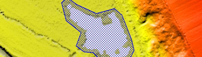


6 Good Foundations LIDAR Z shape patches Avoid selecting null value z points


7 When Filtering Goes Wrong Poorly filtered LIDAR can cause instabilities and negatively affect results Section of the TUFLOW manual
8 When Filtering Goes More Wrong On rare occasions LIDAR may be very badly filtered This may need sending back for re-filtering!
9 Filtered Out Features Filtering may also remove important features, e.g. embankments
10 Filtered Out Features These can be replaced with Z Shapes
11 Filtered Out Features Z shape merging and ignoring points


12 Filtered Out Features This could pick up low points

13 Filtered Out Features Z shape is given NO MERGE in Shape_Options


14 Likely to Offend Small channels that intersect bank boundaries can create problems


15 Likely to Offend If the channel is not important then remove it with a Z shape -99,999 points tell TUFLOW to ignore elevations between that point and next vertices either side
16 Likely to Offend If it is important then consider how to better represent Side spill from ISIS Modelling in 1D Could add a spill from ISIS
17 Ditches Representing ditches Z shape lines can be used, but not always accurate For example, what if the ditch is much more narrow compared to the cell size?


18 Ditches Flow constriction cells could be applied to the ditch Though if the ditch is important may be better to model in 1D or set up a second domain with smaller grid sizes


19 Multiple Domains Flow across 2D-2D link boundaries is often problematic


20 Multiple Domains So try and avoid it as much as possible! Minimise the amount of flood water crossing the boundary Deep water is more problematic


21 Use a Z shape layer to ensure cells along the link in both domains are using the same elevations Set Shape_width to greater than 0, but less than 1.5 times the smaller cell size Multiple Domains
22 River Boundaries Positioning boundaries Take care when placing river boundaries Steep terrain close to boundaries can form small, unstable ponds of water Widening the ISIS channel can help remove instabilities that may be occurring alongside it


23


24 Parallel Channels Parallel rivers not uncommon for these to become unstable!


25 Parallel Channels TUFLOW cells coded out and side spills added to ISIS
26 Time Steps Time steps and Courant numbers Not considered best practice to simply reduce time step for an unstable model If time steps too large though, results may be unstable and meaningless Limiting factor is Courant stability criterion
27 Time Steps 2D domains, Courant number generally needs to be less than 10 and typically around 5 Cr = t 2gH x General rule of thumb aim for timestep between half and a quarter of the grid size
28 Time Steps If terrain is steep and/or flow is supercritical, may be necessary to reduce timestep Mass errors can indicate too large a timestep As of TUFLOW build AA, Map Output Data Types == Cr can be used to output t Courant number

29 ISIS Channel Widths Instabilities can arise if ISIS cross section widths are less than the TUFLOW cell size Keep this in mind when trimming

30 ISIS Channel Widths Extend the cross section to at least one cell width Although two can be better


31 Replacing HX with SX Large areas of flat water on the flood plain can cause instabilities.


32 Replacing HX with SX Replacing these HX connections with SX ones can significantly improve the model here
33 Replacing HX with SX New spill units need to be added to ISIS Two for each river unit (one for each bank) Add HT boundaries so these can be linked to TUFLOW Very time consuming use HX where possible!


34 Replacing HX with SX Before After

35 Good Housekeeping Modelling logs Excellent for keeping track of changes to a model Enables others to see what work has been done
36 Good Housekeeping File naming conventions Establishing a good system can greatly help you and others to understand the model Cuts down on clutter and confusion
37 Good Housekeeping Our convention: RiverName_v01-A_f100 Applies to.ief and.tcf files New MapInfo layers given version number to match version of model run


38 Good Housekeeping We ve found organising files into a logical folder system is a great help Relative path names mean model can be easily moved
39 Diagnosing Problems


40 Diagnostic Files Check the log files (.tlf and/or.zzd) This one failed in TUFLOW
41 Diagnostic Files It s a good way to know where to start looking! This one failed in ISIS
42 Point me to it Message layers Imported from the TUFLOW log folder
43 Diagnosing Faults ISIS plot long section animate stage and flow to check for problems Cross-check with.zzd file


44 Diagnosing Faults SMS results Can be used to check for: Unexpected elevations (ground and water) Mass errors Flow paths


45 Diagnosing Faults Water level lines Useful for mapping outputs, but also for checking water levels in SMS Can help identify areas where there are problems
46 Fixing Model Problems
47 If the.zzd File Reports a Problem The problem is most likely in ISIS (check the long section plot) Sometimes a problem in TUFLOW though (that translates back to the ISIS model)
48 Some common ISIS problems Culverts add hats or enable the automatic hat option! Surcharging bridge units replace with orifice or enable switch ISIS channel widths too low ISIS reach length very small, or very different from TUFLOW Areas of flat water on the floodplain
49 If the.tlf File Reports a Problem The problem is most likely in TUFLOW (check the message layer) Causes will vary for each individual model Some common problems though include
50 Terrain! As mentioned earlier, good terrain is important for a healthy model Check the message layer in MapInfo (or other GIS) Overlay this on your LIDAR (with boundaries and nodes visible) ibl

51 Materials! Sudden changes in materials, usually from rough to smooth, along the flow path can cause problems Import your message layer over your materials layer Use a material patch to help Rough Smooth Patch (with rough material applied) Rough
52 Summary
53 Summary Reviewing and modifying terrain Multiple domains Boundary placement Appropriate time steps Channel widths Good housekeeping Diagnosing faults Some tips for fixing problems


54 ISIS-TUFLOW Healthy Models & Debugging Dan Piggott Edenvale Young
Boundaries of 1D 2D modelling. Suzanne Callaway Senior Hydraulic Modeller
 Boundaries of 1D 2D modelling Suzanne Callaway Senior Hydraulic Modeller Introduction Why is it important to define 1D 2D boundaries carefully? Defining boundaries between 1D and 2D models (Flood Modeller
TUFLOW 1D/2D SURFACE WATER MODELING SYSTEM. 1 Introduction. 2 Background Data
 SURFACE WATER MODELING SYSTEM TUFLOW 1D/2D 1 Introduction This tutorial describes the generation of a 1D TUFLOW project using the SMS interface. It is recommended that the TUFLOW 2D tutorial be done before
v TUFLOW 1D/2D SMS 11.2 Tutorial Time minutes Prerequisites TUFLOW 2D Tutorial
 v. 11.2 SMS 11.2 Tutorial Objectives This tutorial describes the generation of a 1D TUFLOW project using the SMS interface. It is strongly recommended that the TUFLOW 2D tutorial be completed before doing
v TUFLOW-2D Hydrodynamics SMS Tutorials Time minutes Prerequisites Overview Tutorial
 v. 12.2 SMS 12.2 Tutorial TUFLOW-2D Hydrodynamics Objectives This tutorial describes the generation of a TUFLOW project using the SMS interface. This project utilizes only the two dimensional flow calculation
SMS v D Summary Table. SRH-2D Tutorial. Prerequisites. Requirements. Time. Objectives
 SMS v. 12.3 SRH-2D Tutorial Objectives Learn the process of making a summary table to compare the 2D hydraulic model results with 1D hydraulic model results. This tutorial introduces a method of presenting
TUFLOW Urban Flood Models. Introduction. TUFLOW UK 2011 User Group Workshops. Phillip Ryan, Modelling Pipe Networks
 TUFLOW 2011 Modelling Pipe Networks Urban Flood Models 2 Introduction TUFLOW Pipe Networks Culverts Pits (Drains) Manholes / Junctions Linking to ISIS Tips and Tricks 3 1 Pipe Network Elements Lines or
ISIS Free & ISIS Professional Quick Start Guide
 ISIS Free & ISIS Professional Cost effective, integrated modelling solutions Think saving, think ISIS, think Halcrow This quick start guide enables first time users to quickly understand how to use ISIS
ISIS 1D. Quick Start Guide. Cost effective, integrated software solutions ch2mhill.com/isis
 ISIS 1D Quick Start Guide Cost effective, integrated software solutions 0845 094 7990 ch2mhill.com/isis softwaresupport@ch2m.com Table of Contents Overview... 3 1. Starting ISIS and Basic Concepts... 3
2D Model Implementation for Complex Floodplain Studies. Sam Crampton, P.E., CFM Dewberry
 2D Model Implementation for Complex Floodplain Studies Sam Crampton, P.E., CFM Dewberry 2D Case Studies Case Study 1 Rain-on-Grid 2D floodplain simulation for unconfined flat topography in coastal plain
Day 1. HEC-RAS 1-D Training. Rob Keller and Mark Forest. Break (9:45 am to 10:00 am) Lunch (12:00 pm to 1:00 pm)
 Lunch (12:00 pm to 1:00 pm)") Day 1 HEC-RAS 1-D Training Rob Keller and Mark Forest Introductions and Course Objectives (8:00 am to 8:15 am) Introductions: Class and Content Module 1 Open Channel Hydraulics (8:15 am to 9:45 am) Lecture
Day 1 HEC-RAS 1-D Training Rob Keller and Mark Forest Introductions and Course Objectives (8:00 am to 8:15 am) Introductions: Class and Content Module 1 Open Channel Hydraulics (8:15 am to 9:45 am) Lecture
Tips for a Good Meshing Experience
 Tips for a Good Meshing Experience Meshes are very powerful and flexible for modeling 2D overland flows in a complex urban environment. However, complex geometries can be frustrating for many modelers
XP Solutions has a long history of Providing original, high-performing software solutions Leading the industry in customer service and support
 XP Solutions has a long history of Providing original, high-performing software solutions Leading the industry in customer service and support Educating our customers to be more successful in their work.
Representing Detail in Large Hydraulic Models: Lower Thames and Humber Estuary. Neil Hunter, Kevin Haseldine and Matthew Scott
 Representing Detail in Large Hydraulic Models: Lower Thames and Humber Estuary Neil Hunter, Kevin Haseldine and Matthew Scott Overview What do we mean by detail? Lower Thames Humber Estuary How is software
Connecting 1D and 2D Domains
 Connecting 1D and 2D Domains XP Solutions has a long history of Providing original, high-performing software solutions Leading the industry in customer service and support Educating our customers to be
Using HEC-RAS and HEC-GeoRAS for River Modeling Adapted by E. Maurer, using an exercise by V. Merwade, Purdue Univ.
 Introduction Using HEC-RAS and HEC-GeoRAS for River Modeling Adapted by E. Maurer, using an exercise by V. Merwade, Purdue Univ. This tutorial uses the output from HEC_GeoRAS from a prior exercise as input
The TUFLOW Link. Past, Present and Future. Stephanie Dufour
 The TUFLOW Link Past, Present and Future Stephanie Dufour stephanie.dufour@bmtwbm.co.uk Contents PAST Software background Thames Embayments Inundation Study PRESENT Flood Modeller -TUFLOW link Flood Modeller
George Mason University Department of Civil, Environmental and Infrastructure Engineering. Dr. Celso Ferreira
 George Mason University Department of Civil, Environmental and Infrastructure Engineering Dr. Celso Ferreira Exercise Topic: HEC GeoRAS Post-Processing Objectives: This tutorial is designed to walk you
SURFACE WATER MODELING SYSTEM. 2. Change to the Data Files Folder and open the file poway1.xyz.
 SURFACE WATER MODELING SYSTEM Mesh Editing This tutorial lesson teaches manual finite element mesh generation techniques that can be performed using SMS. It gives a brief introduction to tools in SMS that
HECRAS 2D: Are you ready for the revolution in the world of hydraulic modeling?
 HECRAS 2D: Are you ready for the revolution in the world of hydraulic modeling? Rishab Mahajan, Emily Campbell and Matt Bardol March 8, 2017 Outline Reasons for hydraulic modeling 1D Modeling 2D Modeling-
HEC-RAS 3.0 January, 2001 Release Notes
 HEC-RAS 3.0 January, 2001 Release Notes A new version of HEC-RAS (3.0) has been released with significant new features over the previous version (2.21). Version 3.0 includes unsteady flow routing capabilities,
GPU - Next Generation Modeling for Catchment Floodplain Management. ASFPM Conference, Grand Rapids (June 2016) Chris Huxley
 Chris Huxley") GPU - Next Generation Modeling for Catchment Floodplain Management ASFPM Conference, Grand Rapids (June 2016) Chris Huxley Presentation Overview 1. What is GPU flood modeling? 2. What is possible using
GPU - Next Generation Modeling for Catchment Floodplain Management ASFPM Conference, Grand Rapids (June 2016) Chris Huxley Presentation Overview 1. What is GPU flood modeling? 2. What is possible using
v Overview SMS Tutorials Prerequisites Requirements Time Objectives
 v. 12.2 SMS 12.2 Tutorial Overview Objectives This tutorial describes the major components of the SMS interface and gives a brief introduction to the different SMS modules. Ideally, this tutorial should
TUFLOW 2011 ISIS-TUFLOW ISIS-TUFLOW-PIPE. TUFLOW UK 2011 User Group Workshops. Bill Syme, BMT WBM,
 TUFLOW 2011 Selection of New Features in 2010/2011 ISIS-TUFLOW ISIS-TUFLOW now recognises 64-bit TUFLOW versions DP TUFLOW also supported Will need 64-bit ISIS to run 64-bit TUFLOW 2 ISIS-TUFLOW-PIPE ISIS-ESTRY
River Nith restoration, cbec UK Ltd, October 2013 APPENDIX I
 APPENDIX I Modelling methodology used for NFM assessment Appendix I. Modelling Methodology I.1 Modelling Approach I.1.1 Generic Approach Given the technical nature of the modelling and the relatively specialised
2D Modelling Workshop - Sydney 16 June Assessment of Bridge Losses using a Range of 2D Modelling Tools - Andrew McCowan
 2D Modelling Workshop - Sydney 16 June 2015 Assessment of Bridge Losses using a Range of 2D Modelling Tools - Andrew McCowan Introduction Two types of losses considered: Blockage and flow separation losses
v Mesh Editing SMS 11.2 Tutorial Requirements Mesh Module Time minutes Prerequisites None Objectives
 v. 11.2 SMS 11.2 Tutorial Objectives This tutorial lesson teaches manual mesh generation and editing techniques that can be performed using SMS. It should be noted that manual methods are NOT recommended.
Automated Enforcement of High Resolution Terrain Models April 21, Brian K. Gelder, PhD Associate Scientist Iowa State University
 Automated Enforcement of High Resolution Terrain Models April 21, 2015 Brian K. Gelder, PhD Associate Scientist Iowa State University Problem Statement High resolution digital elevation models (DEMs) should
Point Cloud Classification
 Point Cloud Classification Introduction VRMesh provides a powerful point cloud classification and feature extraction solution. It automatically classifies vegetation, building roofs, and ground points.
Advanced 1D/2D Modeling Using HEC-RAS
 Advanced 1D/2D Modeling Using HEC-RAS Davis, California Objectives This is an advanced course in applying computer program HEC-RAS. The course provides participants with the knowledge to effectively use
HEC-RAS. A Tutorial (Model Development of a Small Flume)
") HEC-RAS A Tutorial (Model Development of a Small Flume) HEC-RAS Hydraulic Engineering Center:River Analysis System 1-D step backwater model Utilizes energy equation to compute water surface elevation for
HEC-RAS A Tutorial (Model Development of a Small Flume) HEC-RAS Hydraulic Engineering Center:River Analysis System 1-D step backwater model Utilizes energy equation to compute water surface elevation for
GIS Tools for Hydrology and Hydraulics
 1 OUTLINE GIS Tools for Hydrology and Hydraulics INTRODUCTION Good afternoon! Welcome and thanks for coming. I once heard GIS described as a high-end Swiss Army knife: lots of tools in one little package
Potential Applications of the new InfoWorks ICM Mesh level Zones
 Introduction Potential Applications of the new InfoWorks ICM Mesh level Zones Exciting new functionality has been added to InfoWorks ICM version 5.5 to allow improved editing of the 2D mesh. The new functionality
Flood Inundation Mapping using HEC-RAS
 Flood Inundation Mapping using HEC-RAS Goodell, C. 1 ; Warren, C. 2 WEST Consultants, 2601 25 th St SE, Suite 450, Salem, OR 97302. Abstract Flood inundation mapping is an important tool for municipal
UNDERSTAND HOW TO SET UP AND RUN A HYDRAULIC MODEL IN HEC-RAS CREATE A FLOOD INUNDATION MAP IN ARCGIS.
 CE 412/512, Spring 2017 HW9: Introduction to HEC-RAS and Floodplain Mapping Due: end of class, print and hand in. HEC-RAS is a Hydrologic Modeling System that is designed to describe the physical properties
WMS 10.1 Tutorial Hydraulics and Floodplain Modeling HEC-RAS Analysis Learn how to setup a basic HEC-RAS analysis using WMS
 v. 10.1 WMS 10.1 Tutorial Hydraulics and Floodplain Modeling HEC-RAS Analysis Learn how to setup a basic HEC-RAS analysis using WMS Objectives Learn how to build cross sections, stream centerlines, and
WMS 9.0 Tutorial Hydraulics and Floodplain Modeling HEC-RAS Analysis Learn how to setup a basic HEC-RAS analysis using WMS
 v. 9.0 WMS 9.0 Tutorial Hydraulics and Floodplain Modeling HEC-RAS Analysis Learn how to setup a basic HEC-RAS analysis using WMS Objectives Learn how to build cross sections, stream centerlines, and bank
2D Modeling for Approximate Areas. Monica S. Urisko, P.E. CFM
 2D Modeling for Approximate Areas Monica S. Urisko, P.E. CFM Ferrin P. Affleck, P.E. CFM Outline Types of Modeling Available Steady vs Unsteady 1D vs 2D Software available Basics of 2D modeling Inputs
AEC Logic. AEC Terrain. A program to manage earth works in a construction project. Yudhishtirudu Gaddipati 29-Jun-13
 AEC Logic AEC Terrain A program to manage earth works in a construction project Yudhishtirudu Gaddipati 29-Jun-13 Contents 1 Introduction:... 5 2 Program Launch... 5 2.1 How to Launch Program... 5 2.2
v Mesh Generation SMS Tutorials Prerequisites Requirements Time Objectives
 v. 12.3 SMS 12.3 Tutorial Mesh Generation Objectives This tutorial demostrates the fundamental tools used to generate a mesh in the SMS. Prerequisites SMS Overview SMS Map Module Requirements Mesh Module
Using 2D Schemes to Model Energy Losses at Structures and Bends Beware of Pretty Images!
 Using 2D Schemes to Model Energy Losses at Structures and Bends Beware of Pretty Images! Bill Syme BMT WBM Software Business Manager 2D: Looks impressive, but is it accurate? 2 Form Losses Energy dissipated
PRACTICAL UNIT 1 exercise task
 Practical Unit 1 1 1 PRACTICAL UNIT 1 exercise task Developing a hydraulic model with HEC RAS using schematic river geometry data In the course of practical unit 1 we prepare the input for the execution
Harris County Flood Control District HEC-RAS 2D Modeling Guidelines (Standardizing HEC-RAS 2D Models for Submittal Within Harris County)
") Harris County Flood Control District HEC-RAS 2D Modeling Guidelines (Standardizing HEC-RAS 2D Models for Submittal Within Harris County) Presented by: April 27, 2017 Matthew Zeve, P.E., CFM Harris County
Harris County Flood Control District HEC-RAS 2D Modeling Guidelines (Standardizing HEC-RAS 2D Models for Submittal Within Harris County) Presented by: April 27, 2017 Matthew Zeve, P.E., CFM Harris County
v SMS 11.2 Tutorial Overview Prerequisites Requirements Time Objectives
 v. 11.2 SMS 11.2 Tutorial Overview Objectives This tutorial describes the major components of the SMS interface and gives a brief introduction to the different SMS modules. Ideally, this tutorial should
SMS v Culvert Structures with HY-8. Prerequisites. Requirements. Time. Objectives
 SMS v. 12.1 SRH-2D Tutorial Culvert Structures with HY-8 Objectives This tutorial demonstrates the process of modeling culverts in SRH-2D coupled with the Federal Highway Administrations HY-8 culvert analysis
v SMS 11.1 Tutorial SRH-2D Prerequisites None Time minutes Requirements Map Module Mesh Module Scatter Module Generic Model SRH-2D
 v. 11.1 SMS 11.1 Tutorial SRH-2D Objectives This lesson will teach you how to prepare an unstructured mesh, run the SRH-2D numerical engine and view the results all within SMS. You will start by reading
TUFLOW Two & one-dimensional Unsteady FLOW Software for Rivers, Estuaries and Coastal Waters
 TUFLOW Two & one-dimensional Unsteady FLOW Software for Rivers, Estuaries and Coastal Waters W.J.Syme B.E.(Hons), M.Eng.Sc.(Res) - WBM Oceanics Australia Summary: Once limited to coastal hydraulics, two-dimensional
Steps to Print (without supports) This will take you from Meshmixer to the PSU PrintDepot
 This will take you from Meshmixer to the PSU PrintDepot") Steps to Print (without supports) This will take you from Meshmixer to the PSU PrintDepot Read this first to understand some of the dilemmas a model can have and ways to avoid printing problems: http://www.3dshook.com/2016/05/how-to-optimize-a-3d-model-for-3dprinting/#normal
Steps to Print (without supports) This will take you from Meshmixer to the PSU PrintDepot Read this first to understand some of the dilemmas a model can have and ways to avoid printing problems: http://www.3dshook.com/2016/05/how-to-optimize-a-3d-model-for-3dprinting/#normal
Surfaces - Objectives
 Surfaces - Objectives Cover the Basic DTM Point Types Creating a new InRoads Surface Surface processing in InRoads Loading 3D data into a Surface A bit about Surface Properties Overview of the View Surface
Accuracy of Terrain Elevation Modelling
 Accuracy of Terrain Elevation Modelling 0790 0790 07900 07880 0780 0770 0770 07700 1710 17180 1700 170 170 170 1780 1700 170 Accuracy of Terrain Elevation Modelling By A.G. Barnett and H.L. MacMurray Barnett
FEMA Floodplain Mapping
 FEMA Floodplain Mapping By Luke Sturtevant Introduction The National Flood Insurance Program (NFIP) has compiled massive databases containing information and maps of floodplains for the entire United States.
SMS v Culvert Structures. SRH-2D Tutorial. Prerequisites. Requirements. Time. Objectives
 SMS v. 12.0 SRH-2D Tutorial Objectives This tutorial demonstrates the process of modeling culverts in SRH-2D. The Working with Simulations tutorial should have been completed before attempting this one.
Creating raster DEMs and DSMs from large lidar point collections. Summary. Coming up with a plan. Using the Point To Raster geoprocessing tool
 Page 1 of 5 Creating raster DEMs and DSMs from large lidar point collections ArcGIS 10 Summary Raster, or gridded, elevation models are one of the most common GIS data types. They can be used in many ways
v SMS Tutorials SRH-2D Prerequisites Requirements SRH-2D Model Map Module Mesh Module Data files Time
 v. 11.2 SMS 11.2 Tutorial Objectives This tutorial shows how to build a Sedimentation and River Hydraulics Two-Dimensional () simulation using SMS version 11.2 or later. Prerequisites SMS Overview tutorial
CHAPTER 7 FLOOD HYDRAULICS & HYDROLOGIC VIVEK VERMA
 CHAPTER 7 FLOOD HYDRAULICS & HYDROLOGIC VIVEK VERMA CONTENTS 1. Flow Classification 2. Chezy s and Manning Equation 3. Specific Energy 4. Surface Water Profiles 5. Hydraulic Jump 6. HEC-RAS 7. HEC-HMS
2018 Jacobs
 How to import EACSD cross-sections Flood Modeller allows you to import cross sections defined in EACSD survey files, automatically validating and converting them to Flood Modeller 1D cross sections. The
A Comparative Study of HEC-RAS 2D, TUFLOW, & Mike 21 Model Benchmark Testing
 A Comparative Study of HEC-RAS 2D, TUFLOW, & Mike 21 Model Benchmark Testing June 2016 Presented by: Murari Paudel, PhD, PE, CFM Soledad B Roman, EIT John Prichard, PE, CFM Wood Rodgers Inc. Sacramento,
Content provided in partnership with Que, from the book Show Me Microsoft Office Access 2003 by Steve JohnsonÃÃ
 ,PSURYLQJWKH$SSHDUDQFHRI )RUPVDQGHSRUWV Content provided in partnership with Que, from the book Show Me Microsoft Office Access 00 by Steve JohnsonÃÃ Introduction The objects in a database most on display
This document will cover some of the key features available only in SMS Advanced, including:
 Key Differences between SMS Basic and SMS Advanced SMS Advanced includes all of the same functionality as the SMS Basic Software as well as adding numerous tools that provide management solutions for multiple
Lidar and GIS: Applications and Examples. Dan Hedges Clayton Crawford
 Lidar and GIS: Applications and Examples Dan Hedges Clayton Crawford Outline Data structures, tools, and workflows Assessing lidar point coverage and sample density Creating raster DEMs and DSMs Data area
HEC-RAS 5.0 Training New Zealand Workshop Guide
 HEC-RAS 5.0 Training New Zealand Workshop Guide Prepared by: Krey Price Surface Water Solutions 57 Bromfield Drive Kelmscott WA 6111 Australia Tel. +61 400 367 542 e-mail: info@surfacewater.biz website:
Numerical Hydraulics
 ETHZ, Fall 2017 Numerical Hydraulics Assignment 3 Comparison of two numerical solutions of river flow: use of Finite Elements (HEC-RAS) and Finite Volumes (BASEMENT) 1 Introduction In the course, two different
ADH Rules of Thumb. US Army Corps of Engineers. Coastal and Hydraulics Laboratory Engineer Research & Development Center
 ADH Rules of Thumb Refinement Levels Refinement Levels (ML mat# lev#) allows an element to be divided into a maximum of 2lev# of elements, you may not use all of them depending on the flow conditions and
MIKE FLOOD. Modelling of River Flooding. A Step-by-step training guide. DHI Water & Environment. Agern Allé 5 DK-2970 Hørsholm Denmark
 MIKE FLOOD Modelling of River Flooding A Step-by-step training guide Agern Allé 5 DK-2970 Hørsholm Denmark Tel: +45 4516 9200 Fax: +45 4516 9292 E-mail: dhi@dhigroup.com Web: www.dhigroup.com DHI Software
Introduction Surface Water Modeling System (SMS) & Case Study using SMS 2D Modeling Software
 & Case Study using SMS 2D Modeling Software") A.D. Latornell Conservation Symposium November 18, 2015 Introduction Surface Water Modeling System (SMS) & Case Study using SMS 2D Modeling Software Dr. Bahar SM P.Geo.(Ltd), P Eng 1 Topics Education,
A.D. Latornell Conservation Symposium November 18, 2015 Introduction Surface Water Modeling System (SMS) & Case Study using SMS 2D Modeling Software Dr. Bahar SM P.Geo.(Ltd), P Eng 1 Topics Education,
Objectives This tutorial shows how to use the Map Flood tool to quickly generate floodplain data.
 v. 11.0 WMS 11.0 Tutorial Creating a Objectives This tutorial shows how to use the Map Flood tool to quickly generate floodplain data. Prerequisite Tutorials Introduction to WMS Required Components Scatter
 4.2.3 MODEL DEVELOPMENT The study developed flood mitigation options for the Eltham Road and Madills Farm / Melanesia Road areas. However, as low levels of confidence were associated with the flood h azards
TUFLOW 2017 and 2018 New Features
 TUFLOW 2017 and 2018 New Features Phillip Ryan Software Development Lead 2017 and 2018 Release Since last UK TUFLOW workshop 2017-09 2017-09-AA released in 7 th September 2017 2017-09-AB update 29 th September
Enhancing TUFLOW Output. Introduction. XMDF Output Files. Australian 2011/2012 TUFLOW Workshops. Bill Syme, BMT WBM,
 Enhancing TUFLOW Output Introduction New output options in TUFLOW Animations Recap some underutilised outputs GIS techniques 2 XMDF Output Files Benefits All outputs in one XMDF file Very quick load times
The CaMa-Flood model description
 Japan Agency for Marine-Earth cience and Technology The CaMa-Flood model description Dai Yamazaki JAMTEC Japan Agency for Marine-Earth cience and Technology 4 th ep, 2015 Concepts of the CaMa-Flood development
v SMS 11.1 Tutorial Overview Time minutes
 v. 11.1 SMS 11.1 Tutorial Overview Objectives This tutorial describes the major components of the SMS interface and gives a brief introduction to the different SMS modules. It is suggested that this tutorial
Prepared for CIVE 401 Hydraulic Engineering By Kennard Lai, Patrick Ndolo Goy & Dr. Pierre Julien Fall 2015
 Prepared for CIVE 401 Hydraulic Engineering By Kennard Lai, Patrick Ndolo Goy & Dr. Pierre Julien Fall 2015 Contents Introduction General Philosophy Overview of Capabilities Applications Computational
Surveying Prof. Bharat Lohani Indian Institute of Technology, Kanpur. Lecture - 1 Module - 6 Triangulation and Trilateration
 Surveying Prof. Bharat Lohani Indian Institute of Technology, Kanpur Lecture - 1 Module - 6 Triangulation and Trilateration (Refer Slide Time: 00:21) Welcome to this another lecture on basic surveying.
GIS OPERATION MANUAL
 GIS OPERATION MANUAL 1. Computer System Description Hardware Make Compaq Presario 5004 CPU AMD Athlon 1.1 Ghz Main Memory 640MB CD-ROM 52 X CD-RW 8 X HD 57GB Monitor 19 inch Video Adapter 16 Mb Nvidia
George Mason University Department of Civil, Environmental and Infrastructure Engineering. Dr. Celso Ferreira Prepared by Lora Baumgartner
 George Mason University Department of Civil, Environmental and Infrastructure Engineering Dr. Celso Ferreira Prepared by Lora Baumgartner Exercise Topic: Getting started with HEC GeoRAS Objective: Create
v Scatter Data TINs SMS 12.3 Tutorial Requirements Scatter Module Map Module Time minutes Prerequisites None Objectives
 v. 12.3 SMS 12.3 Tutorial Objectives This tutorial covers the basics of working with TINs (triangulated irregular networks) using the scatter module of SMS, including: importing TIN data, editing and filtering
v SRH-2D Post-Processing SMS 12.3 Tutorial Prerequisites Requirements Time Objectives
 v. 12.3 SMS 12.3 Tutorial SRH-2D Post-Processing Objectives This tutorial illustrates some techniques for manipulating the solution generated by the Sedimentation and River Hydraulics Two-Dimensional (SRH-2D)
Optimate CFD Evaluation Optimate Glider Optimization Case
 Optimate CFD Evaluation Optimate Glider Optimization Case Authors: Nathan Richardson LMMFC CFD Lead 1 Purpose For design optimization, the gold standard would be to put in requirements and have algorithm
Verification and Validation of HEC-RAS 5.1
 Verification and Validation of HEC-RAS 5.1 Gary Brunner 1, P.E., D. WRE, M.ASCE Dr. Alex Sanchez 1 Dr. Tom Molls 2 Dr. David Parr 3 1. USACE Hydrologic Engineering Center, Davis, CA 2. David Ford Consulting
Tutorial 6. Pumping Well and River
 Tutorial 6 Pumping Well and River Table of Contents Objective. 1 Step-by-Step Procedure... 2 Section 1 Data Input. 2 Step 1: Open Adaptive Groundwater Input (.agw) File. 2 Step 2: Pumping Well Design Database
WMS 9.1 Tutorial Hydraulics and Floodplain Modeling Floodplain Delineation Learn how to us the WMS floodplain delineation tools
 v. 9.1 WMS 9.1 Tutorial Hydraulics and Floodplain Modeling Floodplain Delineation Learn how to us the WMS floodplain delineation tools Objectives Experiment with the various floodplain delineation options
Objectives This tutorial shows how to build a Sedimentation and River Hydraulics Two-Dimensional (SRH-2D) simulation.
 simulation.") v. 12.1 SMS 12.1 Tutorial Objectives This tutorial shows how to build a Sedimentation and River Hydraulics Two-Dimensional () simulation. Prerequisites SMS Overview tutorial Requirements Model Map Module
v. 12.1 SMS 12.1 Tutorial Objectives This tutorial shows how to build a Sedimentation and River Hydraulics Two-Dimensional () simulation. Prerequisites SMS Overview tutorial Requirements Model Map Module
SMS v Simulations. SRH-2D Tutorial. Time. Requirements. Prerequisites. Objectives
 SMS v. 12.1 SRH-2D Tutorial Objectives This tutorial will demonstrate the process of creating a new SRH-2D simulation from an existing simulation. This workflow is very useful when adding new features
This tutorial introduces the HEC-RAS model and how it can be used to generate files for use with the HEC-RAS software.
 v. 12.3 SMS 12.3 Tutorial Objectives This tutorial introduces the model and how it can be used to generate files for use with the software. Prerequisites Overview Tutorial Requirements 5.0 Mesh Module
Understanding Geospatial Data Models
 Understanding Geospatial Data Models 1 A geospatial data model is a formal means of representing spatially referenced information. It is a simplified view of physical entities and a conceptualization of
2-D Hydraulic Modeling Theory & Practice
 2-D Hydraulic Modeling Theory & Practice Author: Maged A. Aboelata, PhD, PE, CFM Presenter: Heather Zhao, PE, CFM October 2017 Presentation Outline * 1-D vs. 2-D modeling * Theory of 2-D simulation * Commonly
Floodplain Mapping & Hydraulic Analysis with HEC-GeoRAS and ArcGIS 9.1
 Floodplain Mapping & Hydraulic Analysis with HEC-GeoRAS 4.1.1 and ArcGIS 9.1 Prepared by Sarah Meyer 1 and Francisco Olivera 2, Ph.D., P.E. May 2007 Contents: 1. Goals of Exercise & Additional Resources
Learn the various 3D interpolation methods available in GMS
 v. 10.4 GMS 10.4 Tutorial Learn the various 3D interpolation methods available in GMS Objectives Explore the various 3D interpolation algorithms available in GMS, including IDW and kriging. Visualize the
v. 9.0 GMS 9.0 Tutorial UTEXAS Dam with Seepage Use SEEP2D and UTEXAS to model seepage and slope stability of a earth dam Prerequisite Tutorials None
 v. 9.0 GMS 9.0 Tutorial Use SEEP2D and UTEXAS to model seepage and slope stability of a earth dam Objectives Learn how to build an integrated SEEP2D/UTEXAS model in GMS. Prerequisite Tutorials None Required
In this section you will learn some simple data entry, editing, formatting techniques and some simple formulae. Contents
 In this section you will learn some simple data entry, editing, formatting techniques and some simple formulae. Contents Section Topic Sub-topic Pages Section 2 Spreadsheets Layout and Design S2: 2 3 Formulae
MODFLOW Conceptual Model Approach II Build a multi-layer MODFLOW model using advanced conceptual model techniques
 v. 10.2 GMS 10.2 Tutorial Build a multi-layer MODFLOW model using advanced conceptual model techniques 00 Objectives The conceptual model approach involves using the GIS tools in the Map module to develop
Cross Sections, Profiles, and Rating Curves. Viewing Results From The River System Schematic. Viewing Data Contained in an HEC-DSS File
 C H A P T E R 9 Viewing Results After the model has finished the steady or unsteady flow computations the user can begin to view the output. Output is available in a graphical and tabular format. The current
Technical Documentation Version 7.4. Performance
 Technical Documentation Version 7.4 These documents are copyrighted by the Regents of the University of Colorado. No part of this document may be reproduced, stored in a retrieval system, or transmitted
George Mason University Department of Civil, Environmental and Infrastructure Engineering. Dr. Celso Ferreira Prepared by Lora Baumgartner
 George Mason University Department of Civil, Environmental and Infrastructure Engineering Dr. Celso Ferreira Prepared by Lora Baumgartner Exercise Topic: Getting started with HEC RAS Objective: Create
12d Model Training Notes Training Modules for 12d Model
 12d Model Training Notes Training Modules for 12d Model June 2018 12d Model V11.0 Training Modules for 12d Model Manual June 2018 Disclaimer 12d Model is supplied without any express or implied warranties
Channel Conditions in the Onion Creek Watershed. Integrating High Resolution Elevation Data in Flood Forecasting
 Channel Conditions in the Onion Creek Watershed Integrating High Resolution Elevation Data in Flood Forecasting Lukas Godbout GIS in Water Resources CE394K Fall 2016 Introduction Motivation Flooding is
Working with Transformations on the Coordinate Plane
 Working with Transformations on the Coordinate Plane Movies create the illusion of movement by showing us 24 images per second. When the human eye processes 24 images per second it is interpreted in our
This tutorial shows how to build a Sedimentation and River Hydraulics Two-Dimensional (SRH-2D) simulation. Requirements
 simulation. Requirements") v. 13.0 SMS 13.0 Tutorial Objectives This tutorial shows how to build a Sedimentation and River Hydraulics Two-Dimensional () simulation. Prerequisites SMS Overview tutorial Requirements Model Map Module
v. 13.0 SMS 13.0 Tutorial Objectives This tutorial shows how to build a Sedimentation and River Hydraulics Two-Dimensional () simulation. Prerequisites SMS Overview tutorial Requirements Model Map Module
MODFLOW STR Package The MODFLOW Stream (STR) Package Interface in GMS
 Package Interface in GMS") v. 10.1 GMS 10.1 Tutorial The MODFLOW Stream (STR) Package Interface in GMS Objectives Learn how to create a model containing STR-type streams. Create a conceptual model of the streams using arcs and orient
v. 10.1 GMS 10.1 Tutorial The MODFLOW Stream (STR) Package Interface in GMS Objectives Learn how to create a model containing STR-type streams. Create a conceptual model of the streams using arcs and orient
v Prerequisite Tutorials Required Components Time
 v. 10.0 GMS 10.0 Tutorial MODFLOW Stochastic Modeling, Parameter Randomization Run MODFLOW in Stochastic (Monte Carlo) Mode by Randomly Varying Parameters Objectives Learn how to develop a stochastic (Monte
National Science Foundation Engineering Research Center. Bingcai Zhang BAE Systems San Diego, CA
 Bingcai Zhang BAE Systems San Diego, CA 92127 Bingcai.zhang@BAESystems.com Introduction It is a trivial task for a five-year-old child to recognize and name an object such as a car, house or building.