2D Modeling for Approximate Areas. Monica S. Urisko, P.E. CFM
|
|
|
- Nathaniel Norton
- 5 years ago
- Views:
Transcription

1 2D Modeling for Approximate Areas Monica S. Urisko, P.E. CFM Ferrin P. Affleck, P.E. CFM
2 Outline Types of Modeling Available Steady vs Unsteady 1D vs 2D Software available Basics of 2D modeling Inputs Outputs Things to consider Case Study
3 Types of Modeling Available Steady vs Unsteady 1-dimensional vs 2-dimensional Software
4 Steady vs Unsteady Steady Flow is constant Only need peak Storage not a factor Unsteady Flow changes with time Hydrograph Storage is a factor

5 Unsteady - Hydrograph Steady State

6 Unsteady - Storage
7 1D vs 2D 1-dimensional Node & Link Based Cross sections Junctions Storage Ponds Diversions 2-dimensional Grid or Spatially Based Flow in multiple directions Storage accounted for in model
8 1D Node & Link Based Flow Follows your network Controlled by downstream feature

9 Steady 1D Models Clearly defined channels Structures Flow direction is clear Floodways

10 Unsteady 1D Models Storage significant factor Diversions occur Structures Swamp/wetlands

11 2D Grid Based Flow follows terrain Flow is determined by neighboring water surface elevation

12 fa18 2D Models Storage significant, flat, slow moving Flow paths are unclear Unconfined flooding - structures minimal Alluvial Fans Swamps Size can be a limitation
13 Slide 12 fa18 you could add a slide after this one, "if you really need to use a 1D model, sometimes a 2D model can help you understhow to layout the model." Ferrin Affleck, 03/24/2014

14 How Do I Decide? One type is not necessarily better than another Let your circumstances dictate which model you use
15 Some Products Available Model Steady Unsteady 1D 2D Gage/Regression X HEC-HMS X X HEC-RAS X X X ICPR X X EPA SWMM X X XP SWMM X X X X FLO-2D X X X TUFLOW X X X
16 Basics of 2D Modeling Flo-2D
17 Simple model 2D Inflow (Point or Rain) Topography Infiltration (CN) Manning s roughness Outflow Extras: structures, levees, 1D channels
18 Outputs Water surface elevation grid Depth grid Velocity grid Flow hydrographs at cross sections
19 Things to Consider Be willing to invest some effort into the setup Choose grid cell size Start simple then add detail

20 Case Study Coastal Georgia PMRs Approximate Area Effingham County


21 GUYTONN Bulloch Co. Effective Zone A GA-17 Study Area Effingham Co. Ogeechee River Effective Zone AE Little Ogeechee River Bryan Co.
22 Ogeechee Detailed Study 1D Modeling Work Begins
23 Ogeechee Detailed Study Ogeechee Approximate Study
24 Ogeechee Approximate Study Ogeechee Run Study Ogeechee Detailed Study Little Ogeechee Study

25 What do we do with this area?

26

27 EASY!!!! 1D Approximate Models

28 Let s take a closer look!!!
29 Model split flow? What s happening here?
30 What s happening here?

31 What s happening here?

32 Let s look at this area now
33
34 Model split flow?

35 Model split flow?
36 Let s look at this area now
37

38

39
40 Q ~ 350 cfs
41 Let s think about flow attenuation Too many assumptions???
42
43

44
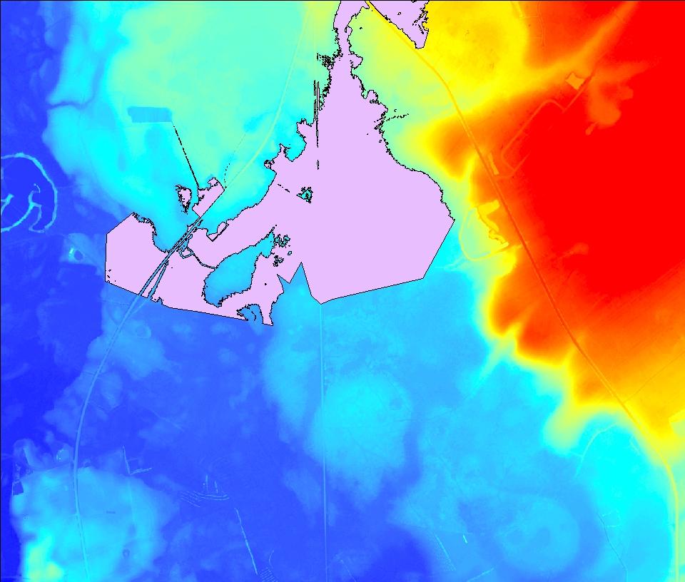
45 Let s try a 2D model for our area Flo2D
46 Flow is unpredictable Split flow 33 sq. mi 100 ft cell size
47 Inputs Inflow - Rain Topo 100 ft cell size from LiDAR Infiltration CN Manning s Land Use and Roads Outflow encompassing watershed

48 Terrain High 112 ft Low 30 ft

49 CN High 98 Low 30
50 Manning s n High 0.2 Low 0.03
51 Case Study Results We have a simple model Good for an approximate area (Zone A) Easier and faster than modeling split flow and flow attenuation

52 Water Surface Elevation

53 Depth over LiDAR Greater than 0.5 ft


54 Floodplains

55 fa6 Floodplains
56 Slide 54 fa6 not sure I like the floodplains hollow, hard to tell what is in/out. can you do a hatch or a transparet fill? Ferrin Affleck, 03/24/2014

57 Floodplains

58
59

60
61 Was the 2D model worth it? 1D Automated tools No additional training Level of Effort: 2-3 days Results: Not very defendable A lot of questionable areas Populated areas needed a better understanding of their flood risk
62 Was the 2D model worth it? 2D 1-day training course (simple 2D model) 1-2 days to create and run an approximate model 1 day for processing results Results: Comparable to 1D results But, captured all the flow split locations and storage areas Still an approximate model (no structures were modeled) Overall, it provides a better picture of the area

63 Was the 2D model worth it for this approximate area? YES!
64 If you really need to use a 1D model, sometimes a 2D model can help you understand how to layout the model.

65

66

67

68
2D Model Implementation for Complex Floodplain Studies. Sam Crampton, P.E., CFM Dewberry
 2D Model Implementation for Complex Floodplain Studies Sam Crampton, P.E., CFM Dewberry 2D Case Studies Case Study 1 Rain-on-Grid 2D floodplain simulation for unconfined flat topography in coastal plain
2-D Hydraulic Modeling Theory & Practice
 2-D Hydraulic Modeling Theory & Practice Author: Maged A. Aboelata, PhD, PE, CFM Presenter: Heather Zhao, PE, CFM October 2017 Presentation Outline * 1-D vs. 2-D modeling * Theory of 2-D simulation * Commonly
Urban Floodplain modeling- Application of Two-Dimensional Analyses to Refine Results
 Urban Floodplain modeling- Application of Two-Dimensional Analyses to Refine Results Prabharanjani Madduri, P.E., CFM Mathini Sreetharan, Ph.D., P.E., CFM Hydraulic modeling of urban areas and issues Modeling
Linear Routing: Floodrouting. HEC-RAS Introduction. Brays Bayou. Uniform Open Channel Flow. v = 1 n R2/3. S S.I. units
 Linear Routing: Floodrouting HEC-RAS Introduction Shirley Clark Penn State Harrisburg Robert Pitt University of Alabama April 26, 2004 Two (2) types of floodrouting of a hydrograph Linear Muskingum Reservoir
HECRAS 2D: Are you ready for the revolution in the world of hydraulic modeling?
 HECRAS 2D: Are you ready for the revolution in the world of hydraulic modeling? Rishab Mahajan, Emily Campbell and Matt Bardol March 8, 2017 Outline Reasons for hydraulic modeling 1D Modeling 2D Modeling-
2014 AWRA Annual Water Resources Conference November 5, 2014 Tysons Corner, VA
 2014 AWRA Annual Water Resources Conference November 5, 2014 Tysons Corner, VA HEC-RAS Overview, History, & Future How HEC-RAS Works Model Development Standard FEMA Assumptions Building A Model FEMA Levels
2D Large Scale Automated Engineering for FEMA Floodplain Development in South Dakota. Eli Gruber, PE Brooke Conner, PE
 2D Large Scale Automated Engineering for FEMA Floodplain Development in South Dakota Eli Gruber, PE Brooke Conner, PE Project Acknowledgments FEMA Region 8 Staff: Brooke Conner, PE Casey Zuzak, GISP Ryan
Advanced 1D/2D Modeling Using HEC-RAS
 Advanced 1D/2D Modeling Using HEC-RAS Davis, California Objectives This is an advanced course in applying computer program HEC-RAS. The course provides participants with the knowledge to effectively use
Comparing 2D Approaches for Complex FEMA Studies
 Comparing 2D Approaches for Complex FEMA Studies Presented by: Ted Cassidy, P.E., PH (STARR2-Dewberry) Sam Crampton, P.E., CFM (STARR2-Dewberry) Mike DePue, P.E., CFM (STARR2-Atkins) Agenda Introduction
2D Hydraulic Modeling, Steering Stream Restoration Design
 2D Hydraulic Modeling, Steering Stream Restoration Design PREPARED FOR: EcoStream 2018 Stream Ecology & Restoration Conference Presented By: Matthew D. Gramza, P.E., CFM, CPESC Civil & Environmental Consultants,
Day 1. HEC-RAS 1-D Training. Rob Keller and Mark Forest. Break (9:45 am to 10:00 am) Lunch (12:00 pm to 1:00 pm)
 Lunch (12:00 pm to 1:00 pm)") Day 1 HEC-RAS 1-D Training Rob Keller and Mark Forest Introductions and Course Objectives (8:00 am to 8:15 am) Introductions: Class and Content Module 1 Open Channel Hydraulics (8:15 am to 9:45 am) Lecture
Day 1 HEC-RAS 1-D Training Rob Keller and Mark Forest Introductions and Course Objectives (8:00 am to 8:15 am) Introductions: Class and Content Module 1 Open Channel Hydraulics (8:15 am to 9:45 am) Lecture
Harris County Flood Control District HEC-RAS 2D Modeling Guidelines (Standardizing HEC-RAS 2D Models for Submittal Within Harris County)
") Harris County Flood Control District HEC-RAS 2D Modeling Guidelines (Standardizing HEC-RAS 2D Models for Submittal Within Harris County) Presented by: April 27, 2017 Matthew Zeve, P.E., CFM Harris County
Harris County Flood Control District HEC-RAS 2D Modeling Guidelines (Standardizing HEC-RAS 2D Models for Submittal Within Harris County) Presented by: April 27, 2017 Matthew Zeve, P.E., CFM Harris County
GPU - Next Generation Modeling for Catchment Floodplain Management. ASFPM Conference, Grand Rapids (June 2016) Chris Huxley
 Chris Huxley") GPU - Next Generation Modeling for Catchment Floodplain Management ASFPM Conference, Grand Rapids (June 2016) Chris Huxley Presentation Overview 1. What is GPU flood modeling? 2. What is possible using
GPU - Next Generation Modeling for Catchment Floodplain Management ASFPM Conference, Grand Rapids (June 2016) Chris Huxley Presentation Overview 1. What is GPU flood modeling? 2. What is possible using
Benefits of 2D Modeling for Urban Stormwater Master Planning Niles, Illinois
 Benefits of 2D Modeling for Urban Stormwater Master Planning Niles, Illinois Patrick Lach, P.E., CFM, Hey and Associates, Inc. Steve Vinezeano, ICMA CM, LEED AP Assistant Village Manager Three Geographic
Cross Sections, Profiles, and Rating Curves. Viewing Results From The River System Schematic. Viewing Data Contained in an HEC-DSS File
 C H A P T E R 9 Viewing Results After the model has finished the steady or unsteady flow computations the user can begin to view the output. Output is available in a graphical and tabular format. The current
This tutorial introduces the HEC-RAS model and how it can be used to generate files for use with the HEC-RAS software.
 v. 12.3 SMS 12.3 Tutorial Objectives This tutorial introduces the model and how it can be used to generate files for use with the software. Prerequisites Overview Tutorial Requirements 5.0 Mesh Module
Verification and Validation of HEC-RAS 5.1
 Verification and Validation of HEC-RAS 5.1 Gary Brunner 1, P.E., D. WRE, M.ASCE Dr. Alex Sanchez 1 Dr. Tom Molls 2 Dr. David Parr 3 1. USACE Hydrologic Engineering Center, Davis, CA 2. David Ford Consulting
Introducion to Hydrologic Engineering Centers River Analysis System (HEC- RAS) Neena Isaac Scientist D CWPRS, Pune -24
 Neena Isaac Scientist D CWPRS, Pune -24") Introducion to Hydrologic Engineering Centers River Analysis System (HEC- RAS) Neena Isaac Scientist D CWPRS, Pune -24 One dimensional river models (1-D models) Assumptions Flow is one dimensional Streamline
Introducion to Hydrologic Engineering Centers River Analysis System (HEC- RAS) Neena Isaac Scientist D CWPRS, Pune -24 One dimensional river models (1-D models) Assumptions Flow is one dimensional Streamline
Watershed Modeling HEC-HMS Interface
 v. 10.1 WMS 10.1 Tutorial Learn how to set up a basic HEC-HMS model using WMS Objectives Build a basic HEC-HMS model from scratch using a DEM, land use, and soil data. Compute the geometric and hydrologic
Efficiency and Accuracy of Importing HEC RAS Datafiles into PCSWMM and SWMM5
 5 Efficiency and Accuracy of Importing HEC RAS Datafiles into PCSWMM and SWMM5 Karen Finney, Rob James, William James and Tiehong Xiao An advantage of USEPA s SWMM5 is its capability to dynamically model
UNDERSTAND HOW TO SET UP AND RUN A HYDRAULIC MODEL IN HEC-RAS CREATE A FLOOD INUNDATION MAP IN ARCGIS.
 CE 412/512, Spring 2017 HW9: Introduction to HEC-RAS and Floodplain Mapping Due: end of class, print and hand in. HEC-RAS is a Hydrologic Modeling System that is designed to describe the physical properties
A Comparative Study of HEC-RAS 2D, TUFLOW, & Mike 21 Model Benchmark Testing
 A Comparative Study of HEC-RAS 2D, TUFLOW, & Mike 21 Model Benchmark Testing June 2016 Presented by: Murari Paudel, PhD, PE, CFM Soledad B Roman, EIT John Prichard, PE, CFM Wood Rodgers Inc. Sacramento,
Connecting 1D and 2D Domains
 Connecting 1D and 2D Domains XP Solutions has a long history of Providing original, high-performing software solutions Leading the industry in customer service and support Educating our customers to be
Module 9. Lecture 3: Major hydrologic models-hspf, HEC and MIKE
 Lecture 3: Major hydrologic models-hspf, HEC and MIKE Major Hydrologic Models HSPF (SWM) HEC MIKE Hydrological Simulation Program-Fortran (HSPF) Commercial successor of the Stanford Watershed Model (SWM-IV)
WMS 9.0 Tutorial Hydraulics and Floodplain Modeling HEC-RAS Analysis Learn how to setup a basic HEC-RAS analysis using WMS
 v. 9.0 WMS 9.0 Tutorial Hydraulics and Floodplain Modeling HEC-RAS Analysis Learn how to setup a basic HEC-RAS analysis using WMS Objectives Learn how to build cross sections, stream centerlines, and bank
WMS 10.1 Tutorial Hydraulics and Floodplain Modeling HEC-RAS Analysis Learn how to setup a basic HEC-RAS analysis using WMS
 v. 10.1 WMS 10.1 Tutorial Hydraulics and Floodplain Modeling HEC-RAS Analysis Learn how to setup a basic HEC-RAS analysis using WMS Objectives Learn how to build cross sections, stream centerlines, and
HCFCD Review Process
 HCFCD Review Process Impact Analysis Local Review LOMR Delegation Local Review This presentation will include: Why is this step important? Process Review Checklist Common Comments 2 Local Review Why is
The HEC-RAS Model Refresher
 The HEC-RAS Model Refresher Minmin Shu P.E. Transportation Review Unit Water Resources Division Michigan Department of Environmental Quality 12-6-2018 What Does the HEC-RAS Mean RAS----River Analysis System
Comparison of 1D and 2D Surface Water Models for Solid Waste Facilities. Garth R. Bowers, P.E., Carl E. Bueter, P.E., Larry Henk
 Comparison of 1D and 2D Surface Water Models for Solid Waste Facilities Garth R. Bowers, P.E., Carl E. Bueter, P.E., Larry Henk Introduction Importance of Accurate Floodplain Delineation Required by Federal
Flood Control Structures Sometimes Neither Fish Nor Fowl
 Proud Titanium Sponsor of the ASFPM 2016 Annual Conference Flood Control Structures Sometimes Neither Fish Nor Fowl David Rubenstein, CFM Jim Murphy, PE, CFM Agenda Approach Study Area Flood Control System
Modeling Storm Sewer Networks in the City of Newport News, Virginia Using Two Different Software Solutions
 Modeling Storm Sewer Networks in the City of Newport News, Virginia Using Two Different Software Solutions Mid-Atlantic Chapter APWA Annual Conference May 9 th, 2013 Overview + Storm Water Modeling Basics
Appendix E. HEC-RAS and HEC-Ecosystem Functions Models
 Appendix E HEC-RAS and HEC-Ecosystem Functions Models 1 Appendix E: Modeled Reaches for the Connecticut River Watershed application of HEC-RAS Separate from the report for the Decision Support System of
HEC-RAS 2D Flood Modelling Tutorial
 HEC-RAS 2D Flood Modelling Tutorial Civil Site Design and HECRAS 2D Flood Modelling HECRAS version 5 and later includes functionality to analyse water flows moving across a surface. this is known as 2D
v. 9.1 WMS 9.1 Tutorial Watershed Modeling HEC-1 Interface Learn how to setup a basic HEC-1 model using WMS
 v. 9.1 WMS 9.1 Tutorial Learn how to setup a basic HEC-1 model using WMS Objectives Build a basic HEC-1 model from scratch using a DEM, land use, and soil data. Compute the geometric and hydrologic parameters
Prof. B.S. Thandaveswara. The computation of a flood wave resulting from a dam break basically involves two
 41.4 Routing The computation of a flood wave resulting from a dam break basically involves two problems, which may be considered jointly or seperately: 1. Determination of the outflow hydrograph from the
Steady Flow Water Surface Profile Computation Using HEC-RAS
 Steady Flow Water Surface Profile Computation Using HEC-RAS Objectives The objective of the course is to enable the participants to perform water surface profile computations using computer program HEC-RAS
Using HEC-RAS and HEC-GeoRAS for River Modeling Adapted by E. Maurer, using an exercise by V. Merwade, Purdue Univ.
 Introduction Using HEC-RAS and HEC-GeoRAS for River Modeling Adapted by E. Maurer, using an exercise by V. Merwade, Purdue Univ. This tutorial uses the output from HEC_GeoRAS from a prior exercise as input
Upper Trinity River Corridor Development Certificate Model Updates. Flood Management Task Force Meeting April 20, 2018
 Upper Trinity River Corridor Development Certificate Model Updates Flood Management Task Force Meeting April 20, 2018 Agenda Review of the Phase II Upper Trinity Watershed CDC Model Development Hydrology
Tips for a Good Meshing Experience
 Tips for a Good Meshing Experience Meshes are very powerful and flexible for modeling 2D overland flows in a complex urban environment. However, complex geometries can be frustrating for many modelers
Integrated Stormwater Management. March 27, 2014
 Integrated Stormwater Management March 27, 2014 Master Plan Development + Alternatives to Address Flooding + Riverine Flooding + Level of Service (LOS) analysis + Identify Capitol Improvement Projects
FLOODPLAIN MODELING USING HEC-RAS
 H A E S T A D M E T H O D S FLOODPLAIN MODELING USING HEC-RAS F i r s t E d i t i o n Authors Haestad Methods Gary Dyhouse Jennifer Hatchett Jeremy Benn Managing Editor Colleen Totz Editors David Klotz,
HEC-RAS 3.0 January, 2001 Release Notes
 HEC-RAS 3.0 January, 2001 Release Notes A new version of HEC-RAS (3.0) has been released with significant new features over the previous version (2.21). Version 3.0 includes unsteady flow routing capabilities,
Hydrologic Modeling using HEC-HMS
 Hydrologic Modeling using HEC-HMS CE 412/512 Spring 2017 Introduction The intent of this exercise is to introduce you to the structure and some of the functions of the HEC-Hydrologic Modeling System (HEC-HMS),
XP Solutions has a long history of Providing original, high-performing software solutions Leading the industry in customer service and support
 XP Solutions has a long history of Providing original, high-performing software solutions Leading the industry in customer service and support Educating our customers to be more successful in their work.
CHAPTER 7 FLOOD HYDRAULICS & HYDROLOGIC VIVEK VERMA
 CHAPTER 7 FLOOD HYDRAULICS & HYDROLOGIC VIVEK VERMA CONTENTS 1. Flow Classification 2. Chezy s and Manning Equation 3. Specific Energy 4. Surface Water Profiles 5. Hydraulic Jump 6. HEC-RAS 7. HEC-HMS
Storm Drain Modeling HY-12 Pump Station
 v. 10.1 WMS 10.1 Tutorial Storm Drain Modeling HY-12 Pump Station Analysis Setup a simple HY-12 pump station storm drain model in the WMS interface with pump and pipe information Objectives Using the HY-12
Bentley OpenRoads Workshop 2017 FLUG Fall Training Event
 Bentley OpenRoads Workshop 2017 FLUG Fall Training Event F-1P - Designing with a Pond Bentley Systems, Incorporated 685 Stockton Drive Exton, PA 19341 www.bentley.com Practice Workbook This workbook is
George Mason University Department of Civil, Environmental and Infrastructure Engineering. Dr. Celso Ferreira
 George Mason University Department of Civil, Environmental and Infrastructure Engineering Dr. Celso Ferreira Exercise Topic: HEC GeoRAS Post-Processing Objectives: This tutorial is designed to walk you
Comparing HEC-RAS v5.0 2-D Results with Verification Datasets
 Comparing HEC-RAS v5.0 2-D Results with Verification Datasets Tom Molls 1, Gary Brunner 2, & Alejandro Sanchez 2 1. David Ford Consulting Engineers, Inc., Sacramento, CA 2. USACE Hydrologic Engineering
v SMS 11.1 Tutorial SRH-2D Prerequisites None Time minutes Requirements Map Module Mesh Module Scatter Module Generic Model SRH-2D
 v. 11.1 SMS 11.1 Tutorial SRH-2D Objectives This lesson will teach you how to prepare an unstructured mesh, run the SRH-2D numerical engine and view the results all within SMS. You will start by reading
ISIS 1D. Quick Start Guide. Cost effective, integrated software solutions ch2mhill.com/isis
 ISIS 1D Quick Start Guide Cost effective, integrated software solutions 0845 094 7990 ch2mhill.com/isis softwaresupport@ch2m.com Table of Contents Overview... 3 1. Starting ISIS and Basic Concepts... 3
Updated on November 10, 2017
 CIVE 7397 Unsteady flows in Rivers and Pipe Networks/Stormwater Management and Modeling / Optimization in Water Resources Engineering Updated on November 10, 2017 Tutorial on using HEC-GeoRAS 10.1 (or
HEC RAS 2D Methods Guidance: South Dakota Large Scale Automated Engineering
 HEC RAS 2D Methods Guidance: South Dakota Large Scale Automated Engineering January, 2017 Prepared by: Compass PTS JV a JV led by AECOM and CDM Smith 3101 Wilson Boulevard, Suite 900 Arlington, VA 22201
2015 HDR, all rights reserved.
 2015 HDR, all rights reserved. An Alternative to HEC-GEORAS: Overview & Comparison of AutoCAD River & Flood Analysis Module Ron Branyon, PE, CFM George Doubleday, EIT, CFM Brandon Hilbrich, PE, CFM TFMA
Flood Inundation Mapping using HEC-RAS
 Flood Inundation Mapping using HEC-RAS Goodell, C. 1 ; Warren, C. 2 WEST Consultants, 2601 25 th St SE, Suite 450, Salem, OR 97302. Abstract Flood inundation mapping is an important tool for municipal
WMS 10.0 Tutorial Storm Drain Modeling SWMM Modeling Learn how to link a hydrologic model to the SWMM storm drain model
 v. 10.0 WMS 10.0 Tutorial Learn how to link a hydrologic model to the SWMM storm drain model Objectives Build a rational method hydrologic model and compute sub-basin flows. Import storm drain network
WMS 9.1 Tutorial Storm Drain Modeling SWMM Modeling Learn how to link a hydrologic model to the SWMM storm drain model
 v. 9.1 WMS 9.1 Tutorial Learn how to link a hydrologic model to the SWMM storm drain model Objectives Build a rational method hydrologic model and compute sub-basin flows. Import storm drain network information
Automatic Discretization and Parameterization of Watersheds using a Digital Elevation Model
 Automatic Discretization and Parameterization of Watersheds using a Digital Elevation Model Ellen Hachborn, Karen Finney, Rob James, Nandana Perera, Tiehong Xiao WaterTech 2017 Computational Hydraulics
FMA 2D Challenge Models 2012
 Summary of the Participation in the 2D Modeling Challenges for 2012 Results of Challenge Models initially were presented at the 1 Day of 2D Symposium September 4, 2012 THOSE WHO PARTICIPATED IN PREPARING
v SMS Tutorials SRH-2D Prerequisites Requirements SRH-2D Model Map Module Mesh Module Data files Time
 v. 11.2 SMS 11.2 Tutorial Objectives This tutorial shows how to build a Sedimentation and River Hydraulics Two-Dimensional () simulation using SMS version 11.2 or later. Prerequisites SMS Overview tutorial
ISIS Free & ISIS Professional Quick Start Guide
 ISIS Free & ISIS Professional Cost effective, integrated modelling solutions Think saving, think ISIS, think Halcrow This quick start guide enables first time users to quickly understand how to use ISIS
FLOODPLAIN MODELING MANUAL. HEC-RAS Procedures for HEC-2 Modelers
 FLOODPLAIN MODELING MANUAL HEC-RAS Procedures for HEC-2 Modelers Federal Emergency Management Agency Mitigation Directorate 500 C Street, SW Washington, DC 20472 April 2002 Floodplain Modeling Manual HEC-RAS
WMS 10.1 Tutorial Hydraulics and Floodplain Modeling Simplified Dam Break Learn how to run a dam break simulation and delineate its floodplain
 v. 10.1 WMS 10.1 Tutorial Hydraulics and Floodplain Modeling Simplified Dam Break Learn how to run a dam break simulation and delineate its floodplain Objectives Setup a conceptual model of stream centerlines
Using 2D Schemes to Model Energy Losses at Structures and Bends Beware of Pretty Images!
 Using 2D Schemes to Model Energy Losses at Structures and Bends Beware of Pretty Images! Bill Syme BMT WBM Software Business Manager 2D: Looks impressive, but is it accurate? 2 Form Losses Energy dissipated
Objectives This tutorial will introduce how to prepare and run a basic ADH model using the SMS interface.
 v. 12.1 SMS 12.1 Tutorial Objectives This tutorial will introduce how to prepare and run a basic ADH model using the SMS interface. Prerequisites Overview Tutorial Requirements ADH Mesh Module Scatter
v TUFLOW-2D Hydrodynamics SMS Tutorials Time minutes Prerequisites Overview Tutorial
 v. 12.2 SMS 12.2 Tutorial TUFLOW-2D Hydrodynamics Objectives This tutorial describes the generation of a TUFLOW project using the SMS interface. This project utilizes only the two dimensional flow calculation
AUTOMATING MANNING S N COEFFICIENT VALUE ASSIGNMENTS FOR HYDRAULIC MODELING
 Imagery Source: Bing Maps via ESRI AUTOMATING MANNING S N COEFFICIENT VALUE ASSIGNMENTS FOR HYDRAULIC MODELING Kyle Gallagher, GISP Black & Veatch Special Projects Corp. Project Overview USACE Tulsa District
Evolution of an Integrated 1D/2D Modeling Package for Urban Drainage
 18 Evolution of an Integrated 1D/2D Modeling Package for Urban Drainage Thomas E. Barnard, Anthony W. Kuch, Geoffrey R. Thompson, Sudesh Mudaliar and Brett C. Phillips Recent flooding events in North America
Reality Check: Processing LiDAR Data. A story of data, more data and some more data
 Reality Check: Processing LiDAR Data A story of data, more data and some more data Red River of the North Red River of the North Red River of the North Red River of the North Introduction and Background
This tutorial shows how to build a Sedimentation and River Hydraulics Two-Dimensional (SRH-2D) simulation. Requirements
 simulation. Requirements") v. 13.0 SMS 13.0 Tutorial Objectives This tutorial shows how to build a Sedimentation and River Hydraulics Two-Dimensional () simulation. Prerequisites SMS Overview tutorial Requirements Model Map Module
v. 13.0 SMS 13.0 Tutorial Objectives This tutorial shows how to build a Sedimentation and River Hydraulics Two-Dimensional () simulation. Prerequisites SMS Overview tutorial Requirements Model Map Module
Hydraulic Modeling with HEC RAS. Susan Cundiff, PE December 4, 2017
 Hydraulic Modeling with HEC RAS Susan Cundiff, PE December 4, 2017 Overview Introduction to HEC RAS Computational Procedures Building a Model Example Projects Introduction to HEC RAS U.S. Army Corps of
WMS 9.1 Tutorial Hydraulics and Floodplain Modeling Floodplain Delineation Learn how to us the WMS floodplain delineation tools
 v. 9.1 WMS 9.1 Tutorial Hydraulics and Floodplain Modeling Floodplain Delineation Learn how to us the WMS floodplain delineation tools Objectives Experiment with the various floodplain delineation options
River Nith restoration, cbec UK Ltd, October 2013 APPENDIX I
 APPENDIX I Modelling methodology used for NFM assessment Appendix I. Modelling Methodology I.1 Modelling Approach I.1.1 Generic Approach Given the technical nature of the modelling and the relatively specialised
A practical approach to floodplain mapping for large-scale catastrophe models
 Flood Recovery, Innovation and Reponse IV 49 A practical approach to floodplain mapping for large-scale catastrophe models I. Carnacina & A. Jemberie Research and Modeling, AIR Worldwide, USA Abstract
 4.2.3 MODEL DEVELOPMENT The study developed flood mitigation options for the Eltham Road and Madills Farm / Melanesia Road areas. However, as low levels of confidence were associated with the flood h azards
v Modeling Orange County Unit Hydrograph GIS Learn how to define a unit hydrograph model for Orange County (California) from GIS data
 from GIS data") v. 10.1 WMS 10.1 Tutorial Modeling Orange County Unit Hydrograph GIS Learn how to define a unit hydrograph model for Orange County (California) from GIS data Objectives This tutorial shows how to define
v. 10.1 WMS 10.1 Tutorial Modeling Orange County Unit Hydrograph GIS Learn how to define a unit hydrograph model for Orange County (California) from GIS data Objectives This tutorial shows how to define
GIS Tools for Hydrology and Hydraulics
 1 OUTLINE GIS Tools for Hydrology and Hydraulics INTRODUCTION Good afternoon! Welcome and thanks for coming. I once heard GIS described as a high-end Swiss Army knife: lots of tools in one little package
George Mason University Department of Civil, Environmental and Infrastructure Engineering. Dr. Celso Ferreira Prepared by Lora Baumgartner
 George Mason University Department of Civil, Environmental and Infrastructure Engineering Dr. Celso Ferreira Prepared by Lora Baumgartner Exercise Topic: Getting started with HEC GeoRAS Objective: Create
Introduction Surface Water Modeling System (SMS) & Case Study using SMS 2D Modeling Software
 & Case Study using SMS 2D Modeling Software") A.D. Latornell Conservation Symposium November 18, 2015 Introduction Surface Water Modeling System (SMS) & Case Study using SMS 2D Modeling Software Dr. Bahar SM P.Geo.(Ltd), P Eng 1 Topics Education,
A.D. Latornell Conservation Symposium November 18, 2015 Introduction Surface Water Modeling System (SMS) & Case Study using SMS 2D Modeling Software Dr. Bahar SM P.Geo.(Ltd), P Eng 1 Topics Education,
TUFLOW 1D/2D SURFACE WATER MODELING SYSTEM. 1 Introduction. 2 Background Data
 SURFACE WATER MODELING SYSTEM TUFLOW 1D/2D 1 Introduction This tutorial describes the generation of a 1D TUFLOW project using the SMS interface. It is recommended that the TUFLOW 2D tutorial be done before
Flow on terrains. Laura Toma csci 3225 Algorithms for GIS Bowdoin College
 Flow on terrains Laura Toma csci 3225 Algorithms for GIS Bowdoin College Overview Flow on grids (discrete) flow direction flow accumulation algorithms for FD and FA dealing with flat areas watershed hierarchy
PRACTICAL UNIT 1 exercise task
 Practical Unit 1 1 1 PRACTICAL UNIT 1 exercise task Developing a hydraulic model with HEC RAS using schematic river geometry data In the course of practical unit 1 we prepare the input for the execution
Learn how to link a hydrologic model to the SWMM storm drain model
 v. 10.1 WMS 10.1 Tutorial Learn how to link a hydrologic model to the SWMM storm drain model Objectives Build a rational method hydrologic model and compute sub-basin flows. Import storm drain network
Algorithms for GIS csci3225
 Algorithms for GIS csci3225 Laura Toma Bowdoin College Flow on digital terrain models (I) Flow Where does the water go when it rains? Flooding: What are the areas susceptible to flooding? Sea level rise:
Hysteresis in River Discharge Rating Curves. Histerésis en las curvas de gasto en ríos (caudal/calado) Madrid, March 25, 2013
 Madrid, March 25, 2013") Hysteresis in River Discharge Rating Curves Histerésis en las curvas de gasto en ríos (caudal/calado) Madrid, March 25, 2013 Marian Muste and Kyutae Lee IIHR Hydroscience & Engineering The University of
Hysteresis in River Discharge Rating Curves Histerésis en las curvas de gasto en ríos (caudal/calado) Madrid, March 25, 2013 Marian Muste and Kyutae Lee IIHR Hydroscience & Engineering The University of
UNCERTAINTY ISSUES IN HYDRODYNAMIC FLOOD MODELING
 UNCERTAINTY ISSUES IN HYDRODYNAMIC FLOOD MODELING Alemseged T. H. a and T. H. M. Rientjes b a Department of Water Resources, ITC, P.O.Box 6, 7500AA, Enschede, The Netherlands. E-mail: haile07634@itc.nl
Integrated 2D Surface-Groundwater Modeling of the Green Swamp, Florida
 Integrated 2D Surface-Groundwater Modeling of the Green Swamp, Florida Peter J. Singhofen, P.E. Gordon L. McClung, P.E Streamline Technologies, Inc. 1900 Town Plaza Ct. Winter Springs, FL 32708 407-679-1696
Objectives This tutorial shows how to build a Sedimentation and River Hydraulics Two-Dimensional (SRH-2D) simulation.
 simulation.") v. 12.1 SMS 12.1 Tutorial Objectives This tutorial shows how to build a Sedimentation and River Hydraulics Two-Dimensional () simulation. Prerequisites SMS Overview tutorial Requirements Model Map Module
v. 12.1 SMS 12.1 Tutorial Objectives This tutorial shows how to build a Sedimentation and River Hydraulics Two-Dimensional () simulation. Prerequisites SMS Overview tutorial Requirements Model Map Module
HEC-RAS. A Tutorial (Model Development of a Small Flume)
") HEC-RAS A Tutorial (Model Development of a Small Flume) HEC-RAS Hydraulic Engineering Center:River Analysis System 1-D step backwater model Utilizes energy equation to compute water surface elevation for
HEC-RAS A Tutorial (Model Development of a Small Flume) HEC-RAS Hydraulic Engineering Center:River Analysis System 1-D step backwater model Utilizes energy equation to compute water surface elevation for
Boundaries of 1D 2D modelling. Suzanne Callaway Senior Hydraulic Modeller
 Boundaries of 1D 2D modelling Suzanne Callaway Senior Hydraulic Modeller Introduction Why is it important to define 1D 2D boundaries carefully? Defining boundaries between 1D and 2D models (Flood Modeller
Generalisation of Topographic resolution for 2D Urban Flood Modelling. Solomon D. Seyoum Ronald Price Zoran Voijnovic
 Generalisation of Topographic resolution for 2D Urban Flood Modelling Solomon D. Seyoum Ronald Price Zoran Voijnovic Outline Introduction Urban Flood Modelling and Topographic data DTM Generalisation Remedial
Prepared for CIVE 401 Hydraulic Engineering By Kennard Lai, Patrick Ndolo Goy & Dr. Pierre Julien Fall 2015
 Prepared for CIVE 401 Hydraulic Engineering By Kennard Lai, Patrick Ndolo Goy & Dr. Pierre Julien Fall 2015 Contents Introduction General Philosophy Overview of Capabilities Applications Computational
Objectives This tutorial demonstrates how to perform unsteady sediment transport simulations in SRH-2D.
 SMS v. 12.2 SRH-2D Tutorial Objectives This tutorial demonstrates how to perform unsteady sediment transport simulations in SRH-2D. Prerequisites SMS Overview tutorial SRH-2D SRH-2D Sediment Transport
Build a MODRAT model by defining a hydrologic schematic
 v. 11.0 WMS 11.0 Tutorial Build a MODRAT model by defining a hydrologic schematic Objectives Learn how to define a basic MODRAT model using the hydrologic schematic tree in WMS by building a tree and defining
Integrated Groundwater Surface Water Modeling of the Green Swamp, Florida
 Integrated Groundwater Surface Water Modeling of the Green Swamp, Florida Data Management Challenges and Opportunities Peter J. Singhofen, P.E. Gordon L. McClung, P.E Streamline Technologies, Inc. 1900
v. 8.4 Prerequisite Tutorials Watershed Modeling Advanced DEM Delineation Techniques Time minutes
 v. 8.4 WMS 8.4 Tutorial Modeling Orange County Rational Method GIS Learn how to define a rational method hydrologic model for Orange County (California) from GIS data Objectives This tutorial shows you
Watershed Modeling Orange County Hydrology Using GIS Data
 v. 9.1 WMS 9.1 Tutorial Watershed Modeling Orange County Hydrology Using GIS Data Learn how to delineate sub-basins and compute soil losses for Orange County (California) hydrologic modeling Objectives
ASFPM / Kansas City Dave Guignet State NFIP Coordinator CTP Mapping Lead May 3, 2017
 ASFPM / Kansas City Dave Guignet State NFIP Coordinator CTP Mapping Lead May 3, 2017 Bio Addition, Revision or Confession. Punxsutawney native! On every Feb 2nd You can now tell your friends that you know
HEC-RAS 5.0 Training New Zealand Workshop Guide
 HEC-RAS 5.0 Training New Zealand Workshop Guide Prepared by: Krey Price Surface Water Solutions 57 Bromfield Drive Kelmscott WA 6111 Australia Tel. +61 400 367 542 e-mail: info@surfacewater.biz website:
Watershed Analysis with the Hydrologic Engineering Center s River Analysis System (HEC-RAS)
") Watershed Analysis with the Hydrologic Engineering Center s River Analysis System (HEC-RAS) by Christopher R. Goodell and Gary W. Brunner PURPOSE: The objectives of this document are to provide a general
Watershed Analysis with the Hydrologic Engineering Center s River Analysis System (HEC-RAS) by Christopher R. Goodell and Gary W. Brunner PURPOSE: The objectives of this document are to provide a general