GEOGRAPHICAL RESEARCH
|
|
|
- Teresa Ferguson
- 5 years ago
- Views:
Transcription
1 GEOGRAPHICAL RESEARCH Vol123, No12 Mar1, 2004 GIS 1,2, 1, 3 (11, ; 21, ; 31, ) : 4D (DEM DOM DLG DRG) GIS, GIS, GIS ; GIS, : 4D ; ; : P208 ; P23115 : (2004) (3D2GIS) GIS,,, GIS 3D2GIS GIS, [1 8 ] [9 ] ;, [10 ], [11 ], 3 D CAD ; : TIN ( Triangu2 lated Irregular Network) CSG(Construction Solid Geometry) [12,13 ], TIN, CSG, CSG ;, Morphing IBR [14 ] ; Angela Antonicelli Plinius,, [15 ], GIS,, 4D (DEM DOM DLG DRG), : ; : : (863) (2001AA135130) ; 211 (2002) : (19722),,,, GIS, 10 E2mail :
2 D,,, [16 ] ( )2,,,, : 2 2 ( / ), ; (2D2GIS ) : 2 2, :,,, ID,,,, 90 60,, 111 GIS,, [9,13 ] : : :, :, :, :,, :, :, (DEM) :, ( Grid) (TIN) (DOM) :,, : : { X 1, Y 1, Z 1 }, { X 2, Y 2, Z 2 }, { Xn, Yn, Zn} :,,,,, { { X 1, Y 1, Z 1 }, { X 2, Y 2, Z 2 }, { Xn, Yn, Zn} } : { { X 11, Y 11, Z 11 }, { X 12, Y 12, Z 12 }, { X 1 n, Y 1 n, Z 1 n} } { { X i1, Y i1, Z i1 }, { X i2, Y i2, Z i2 }, { X i n, Y i n, Z i n} } ( n 2 ; i 2)
3 2 : GIS 267 :, : ( ) ;, :, ID : {ObjectID1, ObjectID2,, ObjectIDn} :,,, { X, Y, Z} :, RGB, : : ( Grid) (TIN),, :, 112 4D DEM DOM DLG DRG 4D (DEM :Digital Elevation Model) ( ) ( X, Y) ( Z) [17 ] DEM, Grid, 4, : Z = a0 + a1 x + a2 y + a3 xy,, DEM, / 215 DEM DEM,, ( ),, ( ), 3D2GIS,, DEM GPS, DEM OEEPE DTM, DTM 0112 %, m Grid DEM VirtuoZo (DOM : Digital Orthophoto Map) (DEM), ( ), DOM, ; ( Pixel),,
4 268 23,,, ( ),,,, (CCD), DOM :, DEM,, DOM DOM DOM DOM, DOM , 50 40cm, 254dpi,, : 5713M (DLG: Digital Line Graphic),,,,,,, DTI (Digital Thematic Information) DLG,, DLG : ( Z ) ; ; DLG, Z, Z DLG,,, ;, (DRG: Digital Raster Graphic),,,, DRG,,, DOM, DRG, ;, DRG DOM DEM ( ) : ;,,,, X, Y, Z
, max ( X B, X D ) ], Y [ min ( Y C, Y D ), max ( Y A, Y B ) ], Z [ min ( Y C, Y D ), max ( Y A, Y B ) ] ( 1 - b) ;,, AB CD AB CD, ( X A, Y A, Z A ), ( X C, Y C, Z C ), ( X B, Y B, Z")
5 2 : GIS 269 ( 1), : 5, 10,, AB CD ( ), AB CD XOY AB CD, ( 1 - a),, AB CD AB AB, ( X A, Y A, Z A ), ( X D, Y D, Z D ), ( X B, Y B, Z B ), ( X C, Y C, Z C ) : a1x + b1y + c1z + d1 = 0, X [ min ( X [ min ( X A, X C ), max ( X B, X D ) ], Y [ min ( Y C, Y D ), max ( Y A, Y B ) ], Z [ min ( Y C, Y D ), max ( Y A, Y B ) ] ( 1 - b) ;,, AB CD AB CD, ( X A, Y A, Z A ), ( X C, Y C, Z C ), ( X B, Y B, Z B ), ( X C, Y D, Z D ) : a2x + b2y+ c2z + d2 = 0, AB CD, ( 1 - c) 1 Fig11 Linear interpolation modeling of oriented curves, K gl 1 gl 2 gl K N ( N 1), S K F 11 ( x, y, z) = 0 F 21 ( x, y, z) = 0 L 1 F 1 k ( x, y, z) = 0 F 2 k ( x, y, z) = 0 L k S : F( x, y, z) = 0, C 2 K C 2 K - 1 C 2 K - 2 C 2 3 C K - 1, (k 2, k ) /
![270 23,, DLG,, Z, (JX4 VirtuoZo ), X Y, ( ) 21112 3DMAX CAD MultiGen, 13ds 1dxf 1dwg [18,19 ],,, 3DMAX,, ; CAD MultiGen,, GIS 3DMAX CAD CCGIS ImaGIS,,, 3DMAX](/docs-images/91/106316040/images/6-1.jpg "ImaGIS,,,,,,,,,,, GIS, DLG, Z,,, ( 2) :, (a), : A k B k C k D k A k, (k = 1, 2, 3, 4) ; (b), ; (c),,,, 21113 GIS DOM, DOM,,, 2 (a b c ) Fig12 3D Graphics of QUE")
6 270 23,, DLG,, Z, (JX4 VirtuoZo ), X Y, ( ) DMAX CAD MultiGen, 13ds 1dxf 1dwg [18,19 ],,, 3DMAX,, ; CAD MultiGen,, GIS 3DMAX CAD CCGIS ImaGIS,,, 3DMAX ImaGIS,,,,,,,,,,, GIS, DLG, Z,,, ( 2) :, (a), : A k B k C k D k A k, (k = 1, 2, 3, 4) ; (b), ; (c),,,, GIS DOM, DOM,,, 2 (a b c ) Fig12 3D Graphics of QUE Pavilion
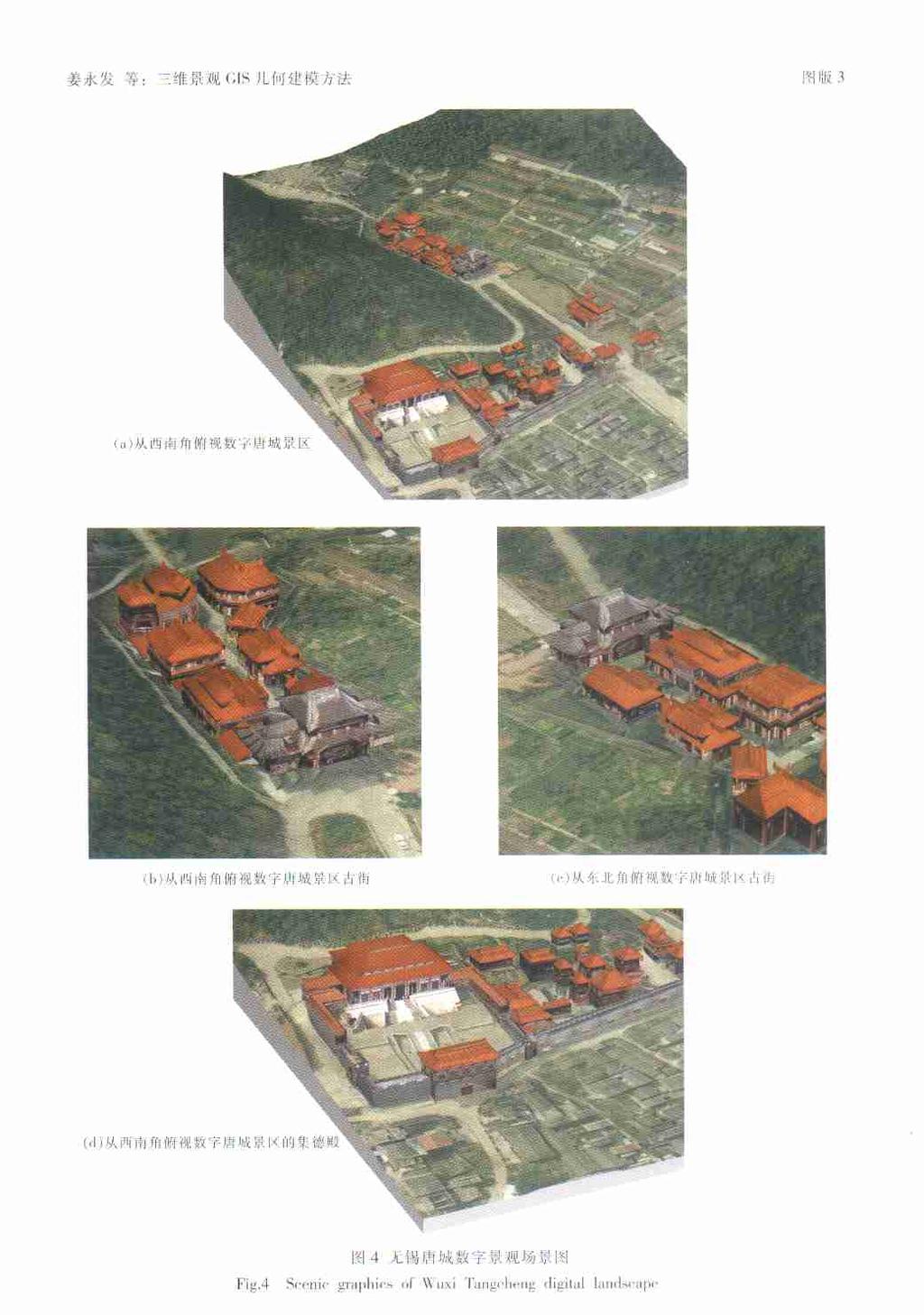
7 2 : GIS 271,,,,,,, DOM ;, ( ),,, 21114,,, DOM,,,, 212 3D2GIS,,,,,,, Photoshop7,,, J PEG, DOM, 3 6 6,,, [20 ],,,,, 1300, DLG,, 3 311, 1998,, , ,, 110 km 2 VirtuoZo312 : 20 DEM dem dem dem dem ; DOM jpg jpg jpg jpg ;
8 xyz xyz xyz xyz 312 ( 3) 313,, IDL ( Interactive Data Language) MRM(Multi2reso2 lution Model), IDL, 4 ( 3) 4 4D, : 1 3 GIS, 4D Fig13 Framework of 3D2GIS, 2 GIS ( ) 3 GIS GIS, GIS, GIS,,,,,,,, GIS : [ 1 ] Gorayska B1 Of minds and men1 In : Advances in Psychology1Edited by Gorayska B and Mey J L1 North2Holland : Elsevier Sci2 ence B1V [ 2 ] 1 1,2003,22(2) : [ 3 ], 1 1 :,20011 [ 4 ] Bishop I D,Karadaglis C1 Linking modelling and visualization for natural resources management1environment and Planning B : Planning and Design, 1997, 24 : [ 5 ],,, 1 1,2002,21(1) : [ 6 ] 1 1 :,19991 [ 7 ] 1 1,2002,31 (1) :7 111 [ 8 ] Batty M and Howes D1 Visualizing urban development1 Geo Info Systems, 1996, 6 (9) : 28 29, 321 [ 9 ], 1 1,1997,22 (1) :7 151 [10 ] Xiaoyong C, Ikeda K1Three2dimensional Modeling of GIS Based on Delaunay Tetrahedral Tessellations1In :International Archives of Photogrammetry and Remote Sensing,Munich,Germany,1994,30 : [11 ], 1 3D 1,2001,6 (6) : [12 ], 1 1,1998,27(4) :
9 2 : GIS 273 [13 ], 1 GIS 1,1997,26 (2) : [14 ],, 1 1,2002,31 (1) : [15 ] Antonicellia,Scisciog,Rosicarellir, et al1exploiting Pompei Cultural Heritage :The Plinius Project1[ s1l1] : Eurographics Associa2 tion,19991 [16 ], 1 1 :, [17 ], 1 1 :, [18 ], 1 GIS 1, 2001,26(1) :9 101 [19 ], 1 : 1,2000,25(4) : [20 ],, 1 1 :, Research on geometry modeling method of three2dimensions landscape GIS : a case study of Tangcheng in Wuxi J IANG Yong2fa 1,2, LV Guo2nian 1, PENG Shi2kui 3 (11Key Lab of Jiangsu of Geographic Information Science, Nanjing Normal University, Nanjing , China ; 21Jiangsu Fundamental Geographic Information Center, Nanjing , China ;31College of Forest Resources and Environment,Nanjing Forestry University,Nanjing , China) Abstract :Starting from the three dimensions and virtual reality, the hot spots of digital Earth and digital city of GIS,this paper analyses the development status of 3D visualization GIS at home and abroad, and discourse upon the key technologies of 3D2GIS1 In view of the specialty of surveying and mapping, the 3D cyber2landscape GIS in Tangcheng of Wuxi was realized based on 4D surveying and mapping data (DEM,DOM,DLG,DRG) 1 In addition, some modifications on traditional 3D spatial data model of GIS were made1the au2 thors think that the division of point object in 3D modeling of object2oriented is different from that of 2D GIS1The single tree of the generally defined point object is usually composed of bulk data storage and one of the difficult technologies of GIS modeling1 At the same time, the authors think that the way of using oriented curves for modeling complicat2 ed geometric objects is simple and direct1 Based on oriented curves the paper makes several descrip2 tions for common geometric objects, and puts forward the mathematical way which constructs simple surface object and complex 3D objects1 As a basic data stream, 4D of surveying and mapping data was modeled by automatic and manual ways through digital technology for editing textures of buildings and linking their attribute data, then the 3D landscape reappearance and virtual reality of Tangcheng scenic spot were completed1 Key words :4D surveying and mapping data ; geometry modeling ; oriented curves
10
GEOGRAPHICAL RESEARCH
 22 2 2003 3 GEOGRAPHICAL RESEARCH Vol1 22, No1 2 Mar1, 2003 (, 100101) : GIS,,,,, (Cudgewa),,,,, : ; ; : P208 ; TP39119 : 100020585 (2003) 0220245208 1,, [1 3 ],,,,,,,,,,,,,, GIS,,,,,,, : 2002209228 ;
Construction of Complex City Landscape with the Support of CAD Model
 Construction of Complex City Landscape with the Support of CAD Model MinSun 1 JunChen 2 AinaiMa 1 1.Institute of RS & GIS, Peking University, Beijing, China, 100871 2.National Geomatics Center of China,
Experiments on Generation of 3D Virtual Geographic Environment Based on Laser Scanning Technique
 Experiments on Generation of 3D Virtual Geographic Environment Based on Laser Scanning Technique Jie Du 1, Fumio Yamazaki 2 Xiaoyong Chen 3 Apisit Eiumnoh 4, Michiro Kusanagi 3, R.P. Shrestha 4 1 School
Review of Cartographic Data Types and Data Models
 Review of Cartographic Data Types and Data Models GIS Data Models Raster Versus Vector in GIS Analysis Fundamental element used to represent spatial features: Raster: pixel or grid cell. Vector: x,y coordinate
Contents of Lecture. Surface (Terrain) Data Models. Terrain Surface Representation. Sampling in Surface Model DEM
 Data Models. Terrain Surface Representation. Sampling in Surface Model DEM") Lecture 13: Advanced Data Models: Terrain mapping and Analysis Contents of Lecture Surface Data Models DEM GRID Model TIN Model Visibility Analysis Geography 373 Spring, 2006 Changjoo Kim 11/29/2006 1
Lecture 13: Advanced Data Models: Terrain mapping and Analysis Contents of Lecture Surface Data Models DEM GRID Model TIN Model Visibility Analysis Geography 373 Spring, 2006 Changjoo Kim 11/29/2006 1
SPATIAL DATA MODELS Introduction to GIS Winter 2015
 SPATIAL DATA MODELS Introduction to GIS Winter 2015 GIS Data Organization The basics Data can be organized in a variety of ways Spatial location, content (attributes), frequency of use Come up with a system
SketchUp. DOM DEM DLG Stereo Analyst 3D LPS 2.1 DEM DOM. ArcGIS DEM DOM [2,7] Geoye-1. ArcGIS. ERDAS SketchUp P208 : B : (2011)
![SketchUp. DOM DEM DLG Stereo Analyst 3D LPS 2.1 DEM DOM. ArcGIS DEM DOM [2,7] Geoye-1. ArcGIS. ERDAS SketchUp P208 : B : (2011)](/thumbs/93/111141158.jpg "SketchUp. DOM DEM DLG Stereo Analyst 3D LPS 2.1 DEM DOM. ArcGIS DEM DOM [2,7] Geoye-1. ArcGIS. ERDAS SketchUp P208 : B : (2011)") 2011 2 9 1 ERDAS SketchUp 1 2 2 (1. 410007 2. 410119) ERDAS Sketchup ERDAS SketchUp Geoye-1 ERDAS SketchUp ArcGIS ERDAS SketchUp Geoye-1 P208 : B : 1672-4623 (2011) 01-0046-04 [1-3] ERDAS DOM DEM DLG Stereo
2011 2 9 1 ERDAS SketchUp 1 2 2 (1. 410007 2. 410119) ERDAS Sketchup ERDAS SketchUp Geoye-1 ERDAS SketchUp ArcGIS ERDAS SketchUp Geoye-1 P208 : B : 1672-4623 (2011) 01-0046-04 [1-3] ERDAS DOM DEM DLG Stereo
Application of Three-dimensional Visualization Technology in Real Estate Management Jian Cui 1,a, Jiju Ma 2,b, Dongling Ma 1, c and Nana Yang 3,d
 Applied Mechanics and Materials Online: 2014-07-04 ISSN: 1662-7482, Vols. 580-583, pp 2765-2768 doi:10.4028/www.scientific.net/amm.580-583.2765 2014 Trans Tech Publications, Switzerland Application of
Implementation of Flight Simulator using 3-Dimensional Terrain Modeling
 Implementation of Flight Simulator using 3-Dimensional Terrain Modeling 1 1, First Author School of Computer Engineering, Hanshin University, Osan City, S. Korea, stryoo@hs.ac.kr Abstract During the last
Class #2. Data Models: maps as models of reality, geographical and attribute measurement & vector and raster (and other) data structures
 data structures") Class #2 Data Models: maps as models of reality, geographical and attribute measurement & vector and raster (and other) data structures Role of a Data Model Levels of Data Model Abstraction GIS as Digital
Class #2 Data Models: maps as models of reality, geographical and attribute measurement & vector and raster (and other) data structures Role of a Data Model Levels of Data Model Abstraction GIS as Digital
Available online at ScienceDirect. Procedia Environmental Sciences 36 (2016 )
") Available online at www.sciencedirect.com ScienceDirect Procedia Environmental Sciences 36 (2016 ) 184 190 International Conference on Geographies of Health and Living in Cities: Making Cities Healthy
Available online at www.sciencedirect.com ScienceDirect Procedia Environmental Sciences 36 (2016 ) 184 190 International Conference on Geographies of Health and Living in Cities: Making Cities Healthy
Graphic Display of Vector Object
 What is GIS? GIS stands for Geographic Information Systems, although the term Geographic Information Science is gaining popularity. A GIS is a software platform for storing, organizing, viewing, querying,
BUILDING DETECTION AND STRUCTURE LINE EXTRACTION FROM AIRBORNE LIDAR DATA
 BUILDING DETECTION AND STRUCTURE LINE EXTRACTION FROM AIRBORNE LIDAR DATA C. K. Wang a,, P.H. Hsu a, * a Dept. of Geomatics, National Cheng Kung University, No.1, University Road, Tainan 701, Taiwan. China-
3D Model - Data Transfer Guide
 Introduction 3D Model - The Leicester City model is a photogrammetric survey based 3D representation of 380ha of Leicester s Central Regeneration Area. The model is to be: Used for marketing and inward
IMPROVING THE ACCURACY OF DIGITAL TERRAIN MODELS
 STUDIA UNIV. BABEŞ BOLYAI, INFORMATICA, Volume XLV, Number 1, 2000 IMPROVING THE ACCURACY OF DIGITAL TERRAIN MODELS GABRIELA DROJ Abstract. The change from paper maps to GIS, in various kinds of geographical
Research on Impact of Ground Control Point Distribution on Image Geometric Rectification Based on Voronoi Diagram
 Available online at www.sciencedirect.com Procedia Environmental Sciences 11 (2011) 365 371 Research on Impact of Ground Control Point Distribution on Image Geometric Rectification Based on Voronoi Diagram
The Research of Real 3D Modeling in the Digital Heritage Protection of Ancient Architecture
 The Research of Real 3D Modeling in the Digital Heritage Protection of Ancient Architecture Conghua Wang 1,2, Shanxin Zhang 1,2, Erping Zhao 1, Xiaodan Guo 1 1. School of Information Engineering Tibet
GEOGRAPHIC INFORMATION SYSTEMS Lecture 25: 3D Analyst
 GEOGRAPHIC INFORMATION SYSTEMS Lecture 25: 3D Analyst 3D Analyst - 3D Analyst is an ArcGIS extension designed to work with TIN data (triangulated irregular network) - many of the tools in 3D Analyst also
Representing Geography
 Data models and axioms Chapters 3 and 7 Representing Geography Road map Representing the real world Conceptual models: objects vs fields Implementation models: vector vs raster Vector topological model
[Youn *, 5(11): November 2018] ISSN DOI /zenodo Impact Factor
![[Youn *, 5(11): November 2018] ISSN DOI /zenodo Impact Factor](/thumbs/91/105079225.jpg "[Youn *, 5(11): November 2018] ISSN DOI /zenodo Impact Factor") GLOBAL JOURNAL OF ENGINEERING SCIENCE AND RESEARCHES AUTOMATIC EXTRACTING DEM FROM DSM WITH CONSECUTIVE MORPHOLOGICAL FILTERING Junhee Youn *1 & Tae-Hoon Kim 2 *1,2 Korea Institute of Civil Engineering
GLOBAL JOURNAL OF ENGINEERING SCIENCE AND RESEARCHES AUTOMATIC EXTRACTING DEM FROM DSM WITH CONSECUTIVE MORPHOLOGICAL FILTERING Junhee Youn *1 & Tae-Hoon Kim 2 *1,2 Korea Institute of Civil Engineering
True 3D Surface Feature Visualization Design and Realization with MapGIS K9
 True 3D Surface Feature Visualization Design and Realization with MapGIS K9 Yuan Yuan, Shao Chun-fu, Ji Xun, Xiang Huaikun and Zhang Wenji Abstract In the True 3D GIS system, obtaining and modeling of
Terms and definitions * keep definitions of processes and terms that may be useful for tests, assignments
 Lecture 1 Core of GIS Thematic layers Terms and definitions * keep definitions of processes and terms that may be useful for tests, assignments Lecture 2 What is GIS? Info: value added data Data to solve
LECTURE 2 SPATIAL DATA MODELS
 LECTURE 2 SPATIAL DATA MODELS Computers and GIS cannot directly be applied to the real world: a data gathering step comes first. Digital computers operate in numbers and characters held internally as binary
Maps as Numbers. Maps as Numbers. Chapter 3: Maps as Numbers 14SND Getting Started with GIS Chapter 3
 Maps as Numbers Getting Started with GIS Chapter 3 Chapter 3: Maps as Numbers 3.1 Representing Maps as Numbers 3.2 Structuring Attributes 3.3 Structuring Maps 3.4 Why Topology Matters 3.5 Formats for GIS
3D GIS MODELING APPLICATION FOR DEVELOPING THE BUTUAN CITY 3D MODEL
 3D GIS MODELING APPLICATION FOR DEVELOPING THE BUTUAN CITY 3D MODEL Alexander T. Demetillo, Michelle V. Japitana and Peter John A. Galamiton CLAIMS-GIS Project, College of Engineering and Information Technology,
The Open Civil Engineering Journal
 Send Orders for Reprints to reprints@benthamscience.ae 114 The Open Civil Engineering Journal, 2016, 10, 114-124 The Open Civil Engineering Journal Content list available at: www.benthamopen.com/tociej/
DIGITAL TERRAIN MODELLING. Endre Katona University of Szeged Department of Informatics
 DIGITAL TERRAIN MODELLING Endre Katona University of Szeged Department of Informatics katona@inf.u-szeged.hu The problem: data sources data structures algorithms DTM = Digital Terrain Model Terrain function:
Statistical surfaces and interpolation. This is lecture ten
 Statistical surfaces and interpolation This is lecture ten Data models for representation of surfaces So far have considered field and object data models (represented by raster and vector data structures).
Algorithms for GIS csci3225
 Algorithms for GIS csci3225 Laura Toma Bowdoin College Spatial data types and models Spatial data in GIS satellite imagery planar maps surfaces networks point cloud (LiDAR) Spatial data in GIS satellite
٥...: (Picture element) Pixel ٧...:
 Pixel ٧...:") ( RS ) : : / : : - ٣... : ٣...: ٤...: ٥...: (Picture element) Pixel ٥...: ٧...: ١٠... : Geo Tiff ١٨... : ١٩... : DEM ٢٨...: ٢ :.. " " RS. :.. Kosmos Land Sat. : : RS :. : (Land Use) :( Change detection
( RS ) : : / : : - ٣... : ٣...: ٤...: ٥...: (Picture element) Pixel ٥...: ٧...: ١٠... : Geo Tiff ١٨... : ١٩... : DEM ٢٨...: ٢ :.. " " RS. :.. Kosmos Land Sat. : : RS :. : (Land Use) :( Change detection
POSITIONING A PIXEL IN A COORDINATE SYSTEM
 GEOREFERENCING AND GEOCODING EARTH OBSERVATION IMAGES GABRIEL PARODI STUDY MATERIAL: PRINCIPLES OF REMOTE SENSING AN INTRODUCTORY TEXTBOOK CHAPTER 6 POSITIONING A PIXEL IN A COORDINATE SYSTEM The essential
3D Terrain Modelling of the Amyntaio Ptolemais Basin
 2nd International Workshop in Geoenvironment and 1 3D Terrain Modelling of the Amyntaio Ptolemais Basin G. Argyris, I. Kapageridis and A. Triantafyllou Department of Geotechnology and Environmental Engineering,
BUILDING RECONSTRUCTION BASED ON THREE-DIMENSIONAL PHOTO-MODELS AND TOPOLOGIC APPROACHES
 BUILDING RECONSTRUCTION BASED ON THREE-DIMENSIONAL PHOTO-MODELS AND TOPOLOGIC APPROACHES Mohamed Nour El Din, O. Al Khalil, Pierre Grussenmeyer, Mathieu Koehl To cite this version: Mohamed Nour El Din,
Understanding Geospatial Data Models
 Understanding Geospatial Data Models 1 A geospatial data model is a formal means of representing spatially referenced information. It is a simplified view of physical entities and a conceptualization of
Investigation of Sampling and Interpolation Techniques for DEMs Derived from Different Data Sources
 Investigation of Sampling and Interpolation Techniques for DEMs Derived from Different Data Sources FARRAG ALI FARRAG 1 and RAGAB KHALIL 2 1: Assistant professor at Civil Engineering Department, Faculty
GIS Visualization, 3D Visualization and Animation. Tomislav Sapic GIS Technologist Faculty of Natural Resources Management Lakehead University
 GIS Visualization, 3D Visualization and Animation Tomislav Sapic GIS Technologist Faculty of Natural Resources Management Lakehead University Definitions 3D Visualization: Presenting or observing spatial,
Raster Data. James Frew ESM 263 Winter
 Raster Data 1 Vector Data Review discrete objects geometry = points by themselves connected lines closed polygons attributes linked to feature ID explicit location every point has coordinates 2 Fields
ABSTRACT 1. INTRODUCTION
 Published in SPIE Proceedings, Vol.3084, 1997, p 336-343 Computer 3-d site model generation based on aerial images Sergei Y. Zheltov, Yuri B. Blokhinov, Alexander A. Stepanov, Sergei V. Skryabin, Alexander
Purpose: To explore the raster grid and vector map element concepts in GIS.
 GIS INTRODUCTION TO RASTER GRIDS AND VECTOR MAP ELEMENTS c:wou:nssi:vecrasex.wpd Purpose: To explore the raster grid and vector map element concepts in GIS. PART A. RASTER GRID NETWORKS Task A- Examine
Rapid Modeling of Digital City Based on Sketchup
 Journal of Mechanical Engineering Research and Developments ISSN: 1024-1752 Website: http://www.jmerd.org Vol. 38, No. 1, 2015, pp. 130-134 J. Y. Li *, H. L. Yuan, & C. Reithmeier Department of Architectural
GIS in agriculture scale farm level - used in agricultural applications - managing crop yields, monitoring crop rotation techniques, and estimate
 Types of Input GIS in agriculture scale farm level - used in agricultural applications - managing crop yields, monitoring crop rotation techniques, and estimate soil loss from individual farms or agricultural
Import, view, edit, convert, and digitize triangulated irregular networks
 v. 10.1 WMS 10.1 Tutorial Import, view, edit, convert, and digitize triangulated irregular networks Objectives Import survey data in an XYZ format. Digitize elevation points using contour imagery. Edit
( scale invariance) [ 1,2 ],
![( scale invariance) [ 1,2 ],](/thumbs/93/111854608.jpg "( scale invariance) [ 1,2 ],") 20 1 2004 1 Geography and Geo - Information Science Vol. 20 No. 1 January 2004 ( 100871) : : ; ; ; : TU984. 1 :A :1672-0504 (2004) 01-0067 - 06 :5 ] ( scale invariance) [ 1 2 ] : ] Berry [ 3 ] 1 [ 4 ]
20 1 2004 1 Geography and Geo - Information Science Vol. 20 No. 1 January 2004 ( 100871) : : ; ; ; : TU984. 1 :A :1672-0504 (2004) 01-0067 - 06 :5 ] ( scale invariance) [ 1 2 ] : ] Berry [ 3 ] 1 [ 4 ]
Assimilation of Break line and LiDAR Data within ESRI s Terrain Data Structure (TDS) for creating a Multi-Resolution Terrain Model
 for creating a Multi-Resolution Terrain Model") Assimilation of Break line and LiDAR Data within ESRI s Terrain Data Structure (TDS) for creating a Multi-Resolution Terrain Model Tarig A. Ali Department of Civil Engineering American University of Sharjah,
Assimilation of Break line and LiDAR Data within ESRI s Terrain Data Structure (TDS) for creating a Multi-Resolution Terrain Model Tarig A. Ali Department of Civil Engineering American University of Sharjah,
Algorithms for GIS. Spatial data: Models and representation (part I) Laura Toma. Bowdoin College
 Laura Toma. Bowdoin College") Algorithms for GIS Spatial data: Models and representation (part I) Laura Toma Bowdoin College Outline Spatial data in GIS applications Point data Networks Terrains Planar maps and meshes Data structures
Algorithms for GIS Spatial data: Models and representation (part I) Laura Toma Bowdoin College Outline Spatial data in GIS applications Point data Networks Terrains Planar maps and meshes Data structures
ATOMI Automatic road centreline extraction
 ATOMI input and output data Ortho images DTM/DSM 2D inaccurate structured road vector data ATOMI Automatic road centreline extraction 3D accurate structured road vector data Classification of roads according
THE DIGITAL ROCK ENGINEERING SYSTEM BASED ON 3D GIS TECHNOLOGY
 THE DIGITAL ROCK ENGINEERING SYSTEM BASED ON 3D GIS TECHNOLOGY Wu Defu a, Peng Pei a, Tor Yam Khoon a a School of Civil and Environmental Engineering, Nanyang Technological University, Singapore, 639798
DATA MODELS IN GIS. Prachi Misra Sahoo I.A.S.R.I., New Delhi
 DATA MODELS IN GIS Prachi Misra Sahoo I.A.S.R.I., New Delhi -110012 1. Introduction GIS depicts the real world through models involving geometry, attributes, relations, and data quality. Here the realization
Lecture 6: GIS Spatial Analysis. GE 118: INTRODUCTION TO GIS Engr. Meriam M. Santillan Caraga State University
 Lecture 6: GIS Spatial Analysis GE 118: INTRODUCTION TO GIS Engr. Meriam M. Santillan Caraga State University 1 Spatial Data It can be most simply defined as information that describes the distribution
Maps as Numbers: Data Models
 Maps as Numbers: Data Models vertices E Reality S E S arcs S E Conceptual Models nodes E Logical Models S Start node E End node S Physical Models 1 The Task An accurate, registered, digital map that can
RealWorld. HUAZHENG Panoramic Photorealistic 3D. Geospatial Data at Engineering Level
 3D RealWorld HUAZHENG Panoramic Photorealistic 3D Geospatial Data at Engineering Level District Drainage Facilities Management Simulate the extreme weather effect on buildings, road networks, and especially
Automated Feature Extraction from Aerial Imagery for Forestry Projects
 Automated Feature Extraction from Aerial Imagery for Forestry Projects Esri UC 2015 UC706 Tuesday July 21 Bart Matthews - Photogrammetrist US Forest Service Southwestern Region Brad Weigle Sr. Program
MONO-IMAGE INTERSECTION FOR ORTHOIMAGE REVISION
 MONO-IMAGE INTERSECTION FOR ORTHOIMAGE REVISION Mohamed Ibrahim Zahran Associate Professor of Surveying and Photogrammetry Faculty of Engineering at Shoubra, Benha University ABSTRACT This research addresses
The GIS Spatial Data Model
 The GIS Spatial Data Model Introduction: Spatial data are what drive a GIS. Every piece of functionality that makes a GIS separate from another analytical environment is rooted in the spatially explicit
Partial Distortion Correction of Remote Sensing Image Rectification Error
 Partial Distortion Correction of Remote Sensing Image Rectification Error Wenzhong Shi (Department of Land Surveying & Geo-Informatics, The Hong Kong Polytechnic University, Hong Kong) Feng Wang (Institute
Lecture 4: Digital Elevation Models
 Lecture 4: Digital Elevation Models GEOG413/613 Dr. Anthony Jjumba 1 Digital Terrain Modeling Terms: DEM, DTM, DTEM, DSM, DHM not synonyms. The concepts they illustrate are different Digital Terrain Modeling
SPOT-1 stereo images taken from different orbits with one month difference
 DSM Generation Almost all HR sensors are stereo capable. Some can produce even triplettes within the same strip (facilitating multi-image matching). Mostly SPOT (1-5) used for stereo and Ikonos (in spite
Geometric Rectification of Remote Sensing Images
 Geometric Rectification of Remote Sensing Images Airborne TerrestriaL Applications Sensor (ATLAS) Nine flight paths were recorded over the city of Providence. 1 True color ATLAS image (bands 4, 2, 1 in
17/07/2013 RASTER DATA STRUCTURE GIS LECTURE 4 GIS DATA MODELS AND STRUCTURES RASTER DATA MODEL& STRUCTURE TIN- TRIANGULAR IRREGULAR NETWORK
 RASTER DATA STRUCTURE GIS LECTURE 4 GIS DATA MODELS AND STRUCTURES Space is subdivided into regular grids of square grid cells or other forms of polygonal meshes known as picture elements (pixels) the
APPROACH TO ACCURATE PHOTOREALISTIC MODEL GENERATION FOR COMPLEX 3D OBJECTS
 Knyaz, Vladimir APPROACH TO ACCURATE PHOTOREALISTIC MODEL GENERATION FOR COMPLEX 3D OBJECTS Vladimir A. Knyaz, Sergey Yu. Zheltov State Research Institute of Aviation System (GosNIIAS), Victorenko str.,
CyberCity Modeler: Automatic Texturing of 3D City Models TerrainView-Web: 3D Web-VRGIS Franz STEIDLER and Michael BECK
 ABSTRACT CyberCity Modeler: Automatic Texturing of 3D City Models TerrainView-Web: 3D Web-VRGIS Franz STEIDLER and Michael BECK (Dr.-Ing. Franz Steidler, CyberCity AG, Dr. Michael Beck, ViewTec AG, Schaffhauserstrasse
Remote sensing techniques applied to seismic vulnerability assessment
 Remote sensing techniques applied to seismic vulnerability assessment JJ Arranz (josejuan.arranz@upm.es), Y. Torres (y.torres@upm.es), A. Haghi (a.haghi@alumnus.upm.es), J. Gaspar (jorge.gaspar@upm.es)
DENSE IMAGE MATCHING FOR MARS EXPRESS HRSC IMAGERY BASED ON PRECISE POINT PREDICTION METHOD
 DENSE IMAGE MATCHING FOR MARS EXPRESS HRSC IMAGERY BASED ON PRECISE POINT PREDICTION METHOD X. Geng a,b *, Q. Xu a, J. Miao b, Y.F. Hou a, S. Xing a, C.Z. Lan a a Information Engineering University, Institute
Automatic Building Extrusion from a TIN model Using LiDAR and Ordnance Survey Landline Data
 Automatic Building Extrusion from a TIN model Using LiDAR and Ordnance Survey Landline Data Rebecca O.C. Tse, Maciej Dakowicz, Christopher Gold and Dave Kidner University of Glamorgan, Treforest, Mid Glamorgan,
Engineering, Korea Advanced Institute of Science and Technology (hytoiy wpark tjkim Working Group
 THE DEVELOPMENT OF AN ACCURATE DEM EXTRACTION STRATEGY FOR SATELLITE IMAGE PAIRS USING EPIPOLARITY OF LINEAR PUSHBROOM SENSORS AND INTELLIGENT INTERPOLATION SCHEME Hae-Yeoun Lee *, Wonkyu Park **, Taejung
N.J.P.L.S. An Introduction to LiDAR Concepts and Applications
 N.J.P.L.S. An Introduction to LiDAR Concepts and Applications Presentation Outline LIDAR Data Capture Advantages of Lidar Technology Basics Intensity and Multiple Returns Lidar Accuracy Airborne Laser
Topic 5: Raster and Vector Data Models
 Geography 38/42:286 GIS 1 Topic 5: Raster and Vector Data Models Chapters 3 & 4: Chang (Chapter 4: DeMers) 1 The Nature of Geographic Data Most features or phenomena occur as either: discrete entities
3D MODELING OF THE U.S.A.M.V. CLUJ-NAPOCA CAMPUS USING INTEGRATED SYSTEM GOOGLE EARTH SKETCHUP AND 3D WAREHOUSE
 3D MODELING OF THE U.S.A.M.V. CLUJ-NAPOCA CAMPUS USING INTEGRATED SYSTEM GOOGLE EARTH SKETCHUP AND 3D WAREHOUSE Sălăgean T., M. Dîrja, M. Ortelecan, N. Pop, Jutka Deak Faculty of Horticulture, University
Municipal Projects in Cambridge Using a LiDAR Dataset. NEURISA Day 2012 Sturbridge, MA
 Municipal Projects in Cambridge Using a LiDAR Dataset NEURISA Day 2012 Sturbridge, MA October 15, 2012 Jeff Amero, GIS Manager, City of Cambridge Presentation Overview Background on the LiDAR dataset Solar
Cultural Heritage. Geometric Recording of Cultural Monuments. Basic Principles of Geometric Recording. Specific requirements
 LOW COST DIGITAL PHOTOGRAMMETRIC TECHNIQUES FOR THE DOCUMENTATION OF CULTURAL HERITAGE Ch. Ioannidis, S. Soile, C. Potsiou Lab. of Photogrammetry School of Rural & Surveying Eng. National Technical University
Georeferencing & Spatial Adjustment
 Georeferencing & Spatial Adjustment Aligning Raster and Vector Data to the Real World Rotation Differential Scaling Distortion Skew Translation 1 The Problem How are geographically unregistered data, either
Virtualizing Boathouses in Dwejra, Malta for Access through WebGIS Applications (Abstract)
") Virtualizing Boathouses in Dwejra, Malta for Access through WebGIS Applications (Abstract) Daniel LANGENHAUN, Erich BUHMANN, Matthias PIETSCH, Santosh CHOUGULE and Philip PAAR 1 Keywords Digital Landscape
Virtualizing Boathouses in Dwejra, Malta for Access through WebGIS Applications (Abstract) Daniel LANGENHAUN, Erich BUHMANN, Matthias PIETSCH, Santosh CHOUGULE and Philip PAAR 1 Keywords Digital Landscape
GEOSPATIAL ENGINEERING COMPETENCIES. Geographic Information Science
 GEOSPATIAL ENGINEERING COMPETENCIES Geographic Information Science The character and structure of spatial information, its methods of capture, organisation, classification, qualification, analysis, management,
8 Geographers Tools: Automated Mapping. Digitizing a Map 2/19/19 IMPORTANT. Revising a Digitized Map. The Digitized Map. vtues., Feb. 26, 2019.
 Next Class: FIRST EXAM 8 Geographers Tools: Automated Mapping vtues., Feb. 26, 2019. Combination of multiple choice questions and map interpretation. Bring a #2 pencil with eraser. Based on class lectures
On three-dimensional visualization of geospatial information: graphics based or imagery based?
 Annals of GIS ISSN: 1947-5683 (Print) 1947-5691 (Online) Journal homepage: http://www.tandfonline.com/loi/tagi20 On three-dimensional visualization of geospatial information: graphics based or imagery
Open Access Implementation Technologies and Procedure of the Real-time Interactive Roaming System of Virtual City
 Send Orders for Reprints to reprints@benthamscience.net The Open Automation and Control Systems Journal, 2013, 5, 21-29 21 Open Access Implementation Technologies and Procedure of the Real-time Interactive
LiDAR Applications. Examples of LiDAR applications. forestry hydrology geology urban applications
 LiDAR Applications Examples of LiDAR applications forestry hydrology geology urban applications 1 Forestry applications canopy heights individual tree and crown mapping estimated DBH and leaf area index
3D CITY MODELLING WITH CYBERCITY-MODELER
 1 3D CITY MODELLING WITH CYBERCITY-MODELER Kilian Ulm 1 and Daniela Poli 1 1. CyberCity AG, Zurich, Switzerland, (kilian.ulm, daniela.poli)@cybercity.tv ABSTRACT 3D city models using stereo aerial-/satellite
Data Representation in Visualisation
 Data Representation in Visualisation Visualisation Lecture 4 Taku Komura Institute for Perception, Action & Behaviour School of Informatics Taku Komura Data Representation 1 Data Representation We have
Digital Raster Acquisition Project Eastern Ontario (DRAPE) 2014 Digital Surface Model and Digital Terrain Model
 2014 Digital Surface Model and Digital Terrain Model") Digital Raster Acquisition Project Eastern Ontario (DRAPE) 2014 Digital Surface Model and Digital Terrain Model User Guide Provincial Mapping Unit Mapping and Information Resources Branch Corporate Management
Digital Raster Acquisition Project Eastern Ontario (DRAPE) 2014 Digital Surface Model and Digital Terrain Model User Guide Provincial Mapping Unit Mapping and Information Resources Branch Corporate Management
Remote Sensing Introduction to the course
 Remote Sensing Introduction to the course Remote Sensing (Prof. L. Biagi) Exploitation of remotely assessed data for information retrieval Data: Digital images of the Earth, obtained by sensors recording
A METHOD TO PREDICT ACCURACY OF LEAST SQUARES SURFACE MATCHING FOR AIRBORNE LASER SCANNING DATA SETS
 A METHOD TO PREDICT ACCURACY OF LEAST SQUARES SURFACE MATCHING FOR AIRBORNE LASER SCANNING DATA SETS Robert Pâquet School of Engineering, University of Newcastle Callaghan, NSW 238, Australia (rpaquet@mail.newcastle.edu.au)
Training i Course Remote Sensing Basic Theory & Image Processing Methods September 2011
 Training i Course Remote Sensing Basic Theory & Image Processing Methods 19 23 September 2011 Geometric Operations Michiel Damen (September 2011) damen@itc.nl ITC FACULTY OF GEO-INFORMATION SCIENCE AND
PRACTICAL METHODS FOR THE VERIFICATION OF COUNTRYWIDE TERRAIN AND SURFACE MODELS
 PRACTICAL METHODS FOR THE VERIFICATION OF COUNTRYWIDE TERRAIN AND SURFACE MODELS Roberto Artuso, Stéphane Bovet, André Streilein roberto.artuso@swisstopo.ch Swiss Federal Office of Topographie, CH-3084
What can we represent as a Surface?
 Geography 38/42:376 GIS II Topic 7: Surface Representation and Analysis (Chang: Chapters 13 & 15) DeMers: Chapter 10 What can we represent as a Surface? Surfaces can be used to represent: Continuously
Photogrammetry and 3D city modelling
 Digital Architecture and Construction 209 Photogrammetry and 3D city modelling Y. Kobayashi School of Architecture and Landscape Architecture, Arizona State University, USA Abstract 3D city modelling and
LiForest Software White paper. TRGS, 3070 M St., Merced, 93610, Phone , LiForest
 0 LiForest LiForest is a platform to manipulate large LiDAR point clouds and extract useful information specifically for forest applications. It integrates a variety of advanced LiDAR processing algorithms
Erda s D irect X IKONOS GIS 3DGIS, Imagine V irtualgis PC I Geomatics PAMAP GIS Topographer ;, NOS QuickB ird WorldV iew ), Aug1, 2010
, Aug1, 2010") 12 4 2010 8 JOURNAL OF GEO2INFORMATION SC IENCE Vol112, No14 Aug1, 2010 Erda s D irect X 1, 1, 1, 2 (1., 100029; 2., 610051) : GIS GIS IKONOS,, DEM,,, ERDAS IMAGINE 3dsMax,,, VC ++ 6. 0, D irectx,, ;,,
12 4 2010 8 JOURNAL OF GEO2INFORMATION SC IENCE Vol112, No14 Aug1, 2010 Erda s D irect X 1, 1, 1, 2 (1., 100029; 2., 610051) : GIS GIS IKONOS,, DEM,,, ERDAS IMAGINE 3dsMax,,, VC ++ 6. 0, D irectx,, ;,,
geobrowser3d.com The Power of 3D GIS Tools in your Browser
 geobrowser3d.com 1 The Power of 3D GIS Tools in your Browser Overview Introduction Modules Success Stories Build your own What is GeoBrowser3D Interactive 3D visualization system Modular platform OGC compliant
GRAPHICS TOOLS FOR THE GENERATION OF LARGE SCALE URBAN SCENES
 GRAPHICS TOOLS FOR THE GENERATION OF LARGE SCALE URBAN SCENES Norbert Haala, Martin Kada, Susanne Becker, Jan Böhm, Yahya Alshawabkeh University of Stuttgart, Institute for Photogrammetry, Germany Forename.Lastname@ifp.uni-stuttgart.de
,,, ], 3000 m 3000 m 3000 m, 10 m Aki [4 ] (1977) [5
![,,, ], 3000 m 3000 m 3000 m, 10 m Aki [4 ] (1977) [5](/thumbs/91/107275539.jpg ",,, ], 3000 m 3000 m 3000 m, 10 m Aki [4 ] (1977) [5") 1 7 3 Vol 17 No 3 2002 9 (445 450) PROGRESS IN GEOPHYSICS Sept 2002 ( 230026) [ ] Coons Bezier B [ ] ;Coons ;Bezier ;B ; [ ] P315 [ ] A [ ] 100422903 (2002) 0320445207 0 [1 ] [2 ] Cagniard Fourier Cagniard
1 7 3 Vol 17 No 3 2002 9 (445 450) PROGRESS IN GEOPHYSICS Sept 2002 ( 230026) [ ] Coons Bezier B [ ] ;Coons ;Bezier ;B ; [ ] P315 [ ] A [ ] 100422903 (2002) 0320445207 0 [1 ] [2 ] Cagniard Fourier Cagniard
AUTOMATIC IMAGE ORIENTATION BY USING GIS DATA
 AUTOMATIC IMAGE ORIENTATION BY USING GIS DATA Jeffrey J. SHAN Geomatics Engineering, School of Civil Engineering Purdue University IN 47907-1284, West Lafayette, U.S.A. jshan@ecn.purdue.edu Working Group
Georeferencing & Spatial Adjustment 2/13/2018
 Georeferencing & Spatial Adjustment The Problem Aligning Raster and Vector Data to the Real World How are geographically unregistered data, either raster or vector, made to align with data that exist in
FOUR ADVANCES IN HANDLING UNCERTAINTIES IN SPATIAL DATA AND ANALYSIS
 FOUR ADVANCES IN HANDLING UNCERTAINTIES IN SPATIAL DATA AND ANALYSIS Wenzhong Shi Advanced Research Centre for Spatial Information Technology Department of Land Surveying and Geo-Informatics The Hong Kong
Processing of laser scanner data algorithms and applications
 Ž. ISPRS Journal of Photogrammetry & Remote Sensing 54 1999 138 147 Processing of laser scanner data algorithms and applications Peter Axelsson ) Department of Geodesy and Photogrammetry, Royal Institute
GIS Workshop Spring 2016
 1/ 14 GIS Geographic Information System. An integrated collection of computer software and data used to view and manage information about geographic places, analyze spatial relationships, and model spatial
AN INTEGRATED APPROACH TO AGRICULTURAL CROP CLASSIFICATION USING SPOT5 HRV IMAGES
 AN INTEGRATED APPROACH TO AGRICULTURAL CROP CLASSIFICATION USING SPOT5 HRV IMAGES Chang Yi 1 1,2,*, Yaozhong Pan 1, 2, Jinshui Zhang 1, 2 College of Resources Science and Technology, Beijing Normal University,
Automatic DTM Extraction from Dense Raw LIDAR Data in Urban Areas
 Automatic DTM Extraction from Dense Raw LIDAR Data in Urban Areas Nizar ABO AKEL, Ofer ZILBERSTEIN and Yerach DOYTSHER, Israel Key words: LIDAR, DSM, urban areas, DTM extraction. SUMMARY Although LIDAR
The Problem. Georeferencing & Spatial Adjustment. Nature Of The Problem: For Example: Georeferencing & Spatial Adjustment 9/20/2016
 Georeferencing & Spatial Adjustment Aligning Raster and Vector Data to the Real World The Problem How are geographically unregistered data, either raster or vector, made to align with data that exist in
High Resolution Laserscanning, not only for 3D-City Models
 Lohr 133 High Resolution Laserscanning, not only for 3D-City Models UWE LOHR, Ravensburg ABSTRACT The TopoSys laserscanner system is designed to produce digital elevation models (DEMs) of the environment