Democratizing Geospatial Modelling:
|
|
|
- Bernice Sharp
- 5 years ago
- Views:
Transcription

1 Democratizing Geospatial Modelling: The Möbius Modellig Platform Patrick Janssen Design Automation Lab
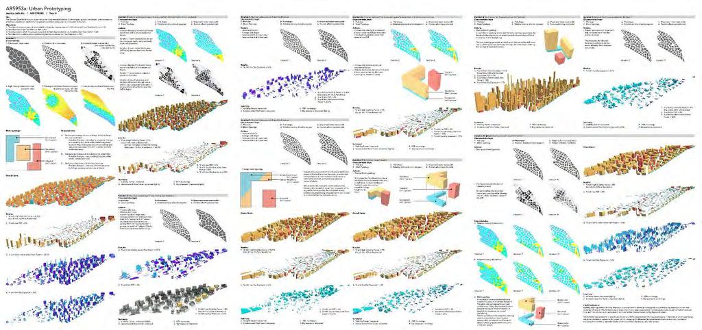
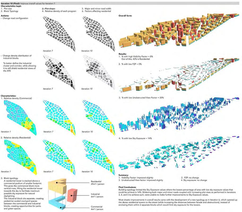
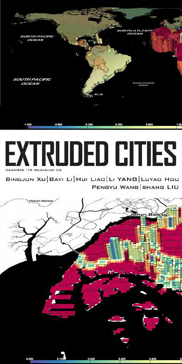
2 2016: Geo-computational Workflows 2018: Urban Prototyping Open Data Design Methods and Tools Democratizing Methods and Tools Möbius Platform Möbius Parametric Modeller Möbius Geospatial Modeller Extruded Cities: Students Next Work Future Work
3 2016: Geo-computational Workflows 2018: Urban Prototyping Open Data Design Methods and Tools Democratizing Methods and Tools Möbius Platform Möbius Parametric Modeller Möbius Geospatial Modeller Extruded Cities: Students Next Work Future Work


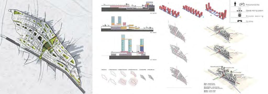
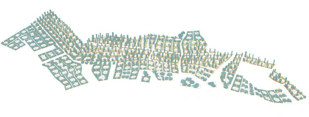
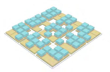
4 Option 1 Plot Ratio Industrial Residential Commercial Total (residents): 910, m buffer: 1% of residents 600m buffer: 6% of residents 900m buffer: 14% of residents 300m 600m 900m People GFA Height


5 Option 2 Plot Ratio Industrial Residential Commercial Total (residents): 650, m buffer: 2% of residents 600m buffer : 9% of residents 900m buffer : 20% of residents 300m 600m 900m People GFA Height
6 Option 1 Option 2 Total (residents): 910, m buffer: 1% of residents 600m buffer: 6% of residents 900m buffer: 14% of residents Total (residents): 650, m buffer: 2% of residents 600m buffer : 9% of residents 900m buffer : 20% of residents
7 2016: Geo-computational Workflows 2018: Urban Prototyping Open Data Design Methods and Tools Democratizing Methods and Tools Möbius Platform Möbius Parametric Modeller Möbius Geospatial Modeller Extruded Cities: Students Next Work Future Work
8
9
10
11 2016: Geo-computational Workflows 2018: Urban Prototyping Open Data Design Methods and Tools Democratizing Methods and Tools Möbius Platform Möbius Parametric Modeller Möbius Geospatial Modeller Extruded Cities: Students Next Work Future Work

12

13
14
15 2016: Geo-computational Workflows 2018: Urban Prototyping Open Data Design Methods and Tools Democratizing Methods and Tools Möbius Platform Möbius Parametric Modeller Möbius Geospatial Modeller Extruded Cities: Students Next Work Future Work
16
17 I AM HERE
18 PAST I AM HERE FUTURE
19 mapping context and data designing PAST I AM HERE FUTURE
20 mapping context and data designing PAST I AM HERE FUTURE

21 I AM NOWHERE
22 2016: Geo-computational Workflows 2018: Urban Prototyping Open Data Design Methods and Tools Democratizing Methods and Tools Möbius Platform Möbius Parametric Modeller Möbius Geospatial Modeller Extruded Cities: Students Next Work Future Work


23 Users Professionals Skill Requirement CAD managers, CAD Researchers, Geo- Informatics Researchers etc. Programmer Specialists General Users Architects, Urban Designers, Planners, Geographers etc. Clients, Citizens etc. Naïve Programmer Non-Programmer Viewers


24 GIS-Ready Visual Programming Web Publication 3D Modelling
25 ArcGIS/CityEngine QGIS CityPlanner QUA-Kit Grasshopper3D Shape Diver Tableau
26 Software Type Visual Programming Online Publishing 3D Modelling ArcGIS GIS Dataflow Yes Upload to ArcGIS Online CityEngine GIS - Yes Upload to ArcGIS Online QGIS GIS - Yes Upload to QGIS Online CityPlanner GIS - Yes Web-based tool QUA-Kit GIS - Yes Web-based tool Grasshopper3D CAD/ GIS (ad-hoc) Yes - Rudimentary Yes - CAD Modelling Capability Yes QGIS3 Yes Rudimentary Yes - Rudimentary Dataflow Yes- ad-hoc Yes CAD Modelling Capability Tableau GIS - Yes -
27 2016: Geo-computational Workflows 2018: Urban Prototyping Open Data Design Methods and Tools Democratizing Methods and Tools Möbius Platform Möbius Parametric Modeller Möbius Geospatial Modeller Extruded Cities: Students Next Work Future Work
28
29 VIEWER CODE
30
31 2016: Geo-computational Workflows 2018: Urban Prototyping Open Data Design Methods and Tools Democratizing Methods and Tools Möbius Platform Möbius Parametric Modeller Möbius Geospatial Modeller Extruded Cities: Students Next Work Future Work
32 Möbius Parametric Modeller gs-viewer gs-json gs-modelling gs: geometry + semantics


33 Topological Modelling Example: OpenCascade A topological model can be considered as a graph of objects with adjacency relationships. In GIS?

34 Topological Modelling OpenCascade Topological types TopAbs contains the TopAbs_ShapeEnum enumeration,which lists the different topological types: COMPOUND a group of any type of topological objects. COMPSOLID a composite solid is a set of solids connected by their faces. It expands the notions of WIRE and SHELL to solids. SOLID a part of space limited by shells. It is three dimensional. SHELL a set of faces connected by their edges. A shell can be open or closed. FACE in 2D it is a part of a plane; in 3D it is a part of a surface. Its geometry is constrained (trimmed) by contours. It is two dimensional. WIRE a set of edges connected by their vertices. It can be an open or closed contour depending on whether the edges are linked or not. EDGE a topological element corresponding to a restrained curve. An edge is generally limited by vertices. It has one dimension. VERTEX a topological element corresponding to a point. It has zero dimension. modeling_data.html
35 Topological Modelling gs-json Example: a polymesh Topological types Geometric objects have four topological component levels: FACE in 2D it is a part of a plane; in 3D it is a part of a surface. Its geometry is constrained (trimmed) by contours. It is two dimensional. WIRE a set of naked edges connected by their vertices. It can be an open or closed contour depending on whether the edges are linked or not. EDGE a topological element corresponding to a restrained curve. An edge is generally limited by vertices. It has one dimension. VERTEX a topological element corresponding to a point. It has zero dimension. GROUP Groups can contain any of the above topological components.
36 Topological Modelling gs-json Example: a polymesh Attributes Attributes are key-value pairs that can be attached to an object or a topo inside an object OBJECT attributes TOPO attributes FACE attributes WIRE attributes EDGE attributes VERTEX attributes Properties Properties are key-value pairs that can be attached to a group. GROUP properties.
37 Topological Modelling gs-json Example: a polymesh JSON Representation In order to keep the representation efficient, edges are only represented implicitly. Polygon mesh: [ ] [ [ [200] [60,61,62,63,64,65,66,67,68,-1], // outer wire [10,11,12,13,-1]] // inner wire [60,61,62,12,11,10,-1], // face 1 [62,63,64,65,13,12,-1], // face 2 [65,66,67,68,10,13,-1]] // face 3
38
39
40 2016: Geo-computational Workflows 2018: Urban Prototyping Open Data Design Methods and Tools Democratizing Methods and Tools Möbius Platform Möbius Parametric Modeller Möbius Geospatial Modeller Extruded Cities: Students Next Work Future Work
41


42 Möbius Geospatial Modeller
43 Möbius Geospatial Modeller BIG DATA MUST BECOME SMALL DATA

44 Möbius Geospatial Modeller

45 Filters Description Published Mode
46 2016: Geo-computational Workflows 2018: Urban Prototyping Open Data Design Methods and Tools Democratizing Methods and Tools Möbius Platform Möbius Parametric Modeller Möbius Geospatial Modeller Extruded Cities: Students Next Work Future Work

47 Extrude Baita Temple Bayi Li, Shanghai University; Wenhan Feng, Shandong University of Science and Technology Extrusion: Tourist Density Color: Consumption Rate

48 Extrude Forbidden City Bayi Li, Shanghai University; Wenhan Feng, Shandong University of Science and Technology Extrusion: Tourist Density Color: Consumption Rate


49 Density of Metropolitan Regions Zixiao Tang, Peking University, Bingjun Xu, Tsinghua University Density of Relationship Between Cities

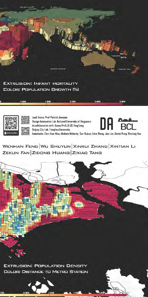
50 Between Mental Health and Urbanisation Liu jiangde, Tongji University Extrusion: Urbanisation Ratio Color: Mental Health

51 Between Mental Health and Urbanisation Liu jiangde, Tongji University Extrusion: Urbanisation Ratio Color: Mental Health

52 Shanghai Transportation Distribution Luyao Hou, Smith College Extrusion: Subway Accessibility Color: Bus Accessibility

53 Social Space Filter Li Yang, The University of Sydney Extrusion: Average Building Height Color: Open Space Ratio


54 The Food Map of Beijing Old City Pengyu Wang,Xiamne University Extrusion: Food Rating Color: Food Price


55 Where Shall the Architects Live Xinrui Zhang 张欣瑞, Central Academy of Fine Arts Extrusion: Years Working Color: Years Working


56 Impacts of Demolitions on Urban Life Zidong Huang, Peking University Extrusion: Demolishion Intensity Color: Urban Life Intensity

57 Tokyo Land Price: Population and Accessibility Shuyun Wu, Southeast University, Hui Liao, Shandong University of Science and Technology Extrusion: Land Price Color: Accessibility


58 Urbanization in China Xintian Li, Southeast University Extrusion: GDP Color: Air Quality Index
59 2016: Geo-computational Workflows 2018: Urban Prototyping Open Data Design Methods and Tools Democratizing Methods and Tools Möbius Platform Möbius Parametric Modeller Möbius Geospatial Modeller Extruded Cities: Students Next Work Future Work
60 Commercial Manufacturing Residential Number of Floors
61
62 2016: Geo-computational Workflows 2018: Urban Prototyping Open Data Design Methods and Tools Democratizing Methods and Tools Möbius Platform Möbius Parametric Modeller Möbius Geospatial Modeller Extruded Cities: Students Next Work Future Work
63 ?
64 Möbius Statistical Modeller
65
66

67 design-automation.net
Methods and Tools for Urban Design. Patrick Janssen
 Methods and Tools for Urban Design Patrick Janssen patrick@janssen.name Context Issue Case Study Stage 1 Data Collection Stage 2 Data Synthesis Stage 3 Data Mining Parametric CAD to GIS Parametric CAD
Parametric Modeling Design and Modeling 2011 Project Lead The Way, Inc.
 Parametric Modeling Design and Modeling 2011 Project Lead The Way, Inc. 3D Modeling Steps - Sketch Step 1 Sketch Geometry Sketch Geometry Line Sketch Tool 3D Modeling Steps - Constrain Step 1 Sketch Geometry
Geometric Modeling Topics
 Geometric Modeling Topics George Allen, george.allen@siemens.com Outline General background Convergent modeling Multi-material objects Giga-face lattices Page 2 Boundary Representation (b-rep) Topology
3D GIS MODELING APPLICATION FOR DEVELOPING THE BUTUAN CITY 3D MODEL
 3D GIS MODELING APPLICATION FOR DEVELOPING THE BUTUAN CITY 3D MODEL Alexander T. Demetillo, Michelle V. Japitana and Peter John A. Galamiton CLAIMS-GIS Project, College of Engineering and Information Technology,
Conceptual Design Modeling in Autodesk Revit Architecture 2010
 Autodesk Revit Architecture 2010 Conceptual Design Modeling in Autodesk Revit Architecture 2010 In building design, visualizing a form in the earliest stages enhances a designer s ability to communicate
Engineering Drawing II
 Instructional Unit Basic Shading and Rendering -Basic Shading -Students will be able -Demonstrate the ability Class Discussions 3.1.12.B, -Basic Rendering to shade a 3D model to apply shading to a 3D 3.2.12.C,
Parametric Urban Patterns
 Parametric Urban Patterns Exploring and integrating graph-based spatial properties in parametric urban modelling Martin Bielik 1, Sven Schneider 2 and Reinhard König 3 Bauhaus-University Weimar, Germany
From 2D to 3D at Esri
 From 2D to 3D at Esri Paul Hardy, Esri Inc phardy@esri.com, Cambridge, UK SHORT PAPER This short paper provides an overview of the 3D capabilities of a modern GIS, illustrated by the Esri ArcGIS system,
Study on Delaunay Triangulation with the Islets Constraints
 Intelligent Information Management, 2010, 2, 375-379 doi:10.4236/iim.2010.26045 Published Online June 2010 (http://www.scirp.org/journal/iim) Study on Delaunay Triangulation with the Islets Constraints
GIS based database of geological/reserve extent maps for E&P Companies. Dr. Achintya Pal Consultant/Domain Expert, ONGC India
 GIS based database of geological/reserve extent maps for E&P Companies Dr. Achintya Pal Consultant/Domain Expert, ONGC India Presentation Overview: Introduction to creation of corporate database of Interpretation
From 2D to 3D at Esri
 From 2D to 3D at Esri OGC/EuroSDR workshop on CityGML in National Mapping Paul Hardy phardy@esri.com Business Development Consultant National Mapping & Cadastre Esri 3D GIS Visualize Manage Share Analyze
3D Validation of CityGML
 3D Validation of CityGML Hugo Ledoux GIS technology group 10 March 2009 CityGML Information model for exchange and storage of 3D city models Based on GML (thus XML-based) Now an international standard
A procedure for generating well-formed street networks
 N. Gu, S. Watanabe, H. Erhan, M. Hank Haeusler, W. Huang, R. Sosa (eds.), Rethinking Comprehensive Design: Speculative Counterculture, Proceedings of the 19th International Conference on Computer- Aided
Selective 4D modelling framework for spatialtemporal Land Information Management System
 Selective 4D modelling framework for spatialtemporal Land Information Management System A. Doulamis, S. Soile, N. Doulamis, C. Chrisouli, N. Grammalidis, K. Dimitropoulos C. Manesis, C. Potsiou, C. Ioannidis
PARAMETRIC MODELING FOR MECHANICAL COMPONENTS 1
 PARAMETRIC MODELING FOR MECHANICAL COMPONENTS 1 Wawre S.S. Abstract: parametric modeling is a technique to generalize specific solid model. This generalization of the solid model is used to automate modeling
Computer Aided Engineering Applications
 Computer Aided Engineering Applications 1A.Geometric Modeling 1.1 Geometric modelling methods 1.2 Data representation 1.3 Modeling functions 1.4 Structure of a CAD system Engi 6928 - Fall 2014 1.Geometric
Parametric Design of Outdoor Broadcasting Studio Based on Schema Theory
 MATEC Web of Conferences 82, Parametric Design of Outdoor Broadcasting Studio Based on Schema Theory Li Zhu 1, Nan Zhang 1, a and Xiaoying Qing 2 1 School of Architecture and Art, Central South University,
Esri CityEngine and the Oculus Rift: GIS for Next-Generation Virtual Reality
 Esri CityEngine and the Oculus Rift: GIS for Next-Generation Virtual Reality Brooks Patrick Solutions Engineer 3D Markets BPatrick@esri.com Esri UC 2014 Technical Workshop The entertainment industry continues
International Conference on Advances in Mechanical Engineering and Industrial Informatics (AMEII 2015)
") International Conference on Advances in Mechanical Engineering and Industrial Informatics (AMEII 2015) Analysis of the Modeling Method and Application of 3D City Model based on the Cityengine Xifang JIN
International Conference on Advances in Mechanical Engineering and Industrial Informatics (AMEII 2015) Analysis of the Modeling Method and Application of 3D City Model based on the Cityengine Xifang JIN
Development of Reverse Engineering System for Machine Engineering Using 3D Bit-map Data. Tatsuro Yashiki* and Tarou Takagi*
 Development of Reverse Engineering System for Machine Engineering Using 3D Bit-map Data Tatsuro Yashiki* and Tarou Takagi* *Power & Industrial Systems R&D Laboratory, Hitachi, Ltd. Abstract In this paper,
Application of Three-dimensional Visualization Technology in Real Estate Management Jian Cui 1,a, Jiju Ma 2,b, Dongling Ma 1, c and Nana Yang 3,d
 Applied Mechanics and Materials Online: 2014-07-04 ISSN: 1662-7482, Vols. 580-583, pp 2765-2768 doi:10.4028/www.scientific.net/amm.580-583.2765 2014 Trans Tech Publications, Switzerland Application of
6th International Conference on Management, Education, Information and Control (MEICI 2016)
") The Simulation Study of the Locking Device in Platform Screen Door System Haiying Zhang 1 a, Weiyan Xu 1 b* and Xiangyan Yu 2,c 1 Qingdao Binhai University, Qingdao, China, 266555 2 Qingdao Qian wan Container
The Simulation Study of the Locking Device in Platform Screen Door System Haiying Zhang 1 a, Weiyan Xu 1 b* and Xiangyan Yu 2,c 1 Qingdao Binhai University, Qingdao, China, 266555 2 Qingdao Qian wan Container
Meshing of flow and heat transfer problems
 Meshing of flow and heat transfer problems Luyao Zou a, Zhe Li b, Qiqi Fu c and Lujie Sun d School of, Shandong University of science and technology, Shandong 266590, China. a zouluyaoxf@163.com, b 1214164853@qq.com,
Development of a Rapid Design System for Aerial Work Truck Subframe with UG Secondary Development Framework
 Available online at www.sciencedirect.com Procedia Engineering 15 (2011) 2961 2965 Advanced in Control Engineering and Information Science Development of a Rapid Design System for Aerial Work Truck Subframe
FACET SHIFT ALGORITHM BASED ON MINIMAL DISTANCE IN SIMPLIFICATION OF BUILDINGS WITH PARALLEL STRUCTURE
 FACET SHIFT ALGORITHM BASED ON MINIMAL DISTANCE IN SIMPLIFICATION OF BUILDINGS WITH PARALLEL STRUCTURE GE Lei, WU Fang, QIAN Haizhong, ZHAI Renjian Institute of Surveying and Mapping Information Engineering
PARAMETERIZE URBAN DESIGN CODES WITH BIM AND OBJECT-ORIENTED PROGRAMMING
 R. Stouffs, P. Janssen, S. Roudavski, B. Tunçer (eds.), Open Systems: Proceedings of the 18th International Conference on Computer-Aided Architectural Design Research in Asia (CAADRIA 2013), 33 42. 2013,
CHANGE-ONLY MODELING IN NAVIGATION GEO-DATABASES
 CHANGE-ONLY MODELING IN NAVIGATION GEO-DATABASES YING Shen a, LI Lin a, LIU Xiaofei a, ZHAO Hu a, LI Dan b a School of Resource and Environment Science, Wuhan University.29 LUOYU Road, Wuhan 430079China.
INDICATE: TOWARDS THE DEVELOPMENT OF A VIRTUAL CITY MODEL, USING A 3D MODEL OF DUNDALK CITY
 INDICATE: TOWARDS THE DEVELOPMENT OF A VIRTUAL CITY MODEL, USING A 3D MODEL OF DUNDALK CITY AM Aidan Melia 1 ; EN Eoin Nolan 1 ; Ruth Kerrigan 1 1: Integrated Environmental Solutions, Helix Building, West
Review of Cartographic Data Types and Data Models
 Review of Cartographic Data Types and Data Models GIS Data Models Raster Versus Vector in GIS Analysis Fundamental element used to represent spatial features: Raster: pixel or grid cell. Vector: x,y coordinate
Exercise 16: Magnetostatics
 Exercise 16: Magnetostatics Magnetostatics is part of the huge field of electrodynamics, founding on the well-known Maxwell-equations. Time-dependent terms are completely neglected in the computation of
COMPUTER AIDED ENGINEERING. Part-1
 COMPUTER AIDED ENGINEERING Course no. 7962 Finite Element Modelling and Simulation Finite Element Modelling and Simulation Part-1 Modeling & Simulation System A system exists and operates in time and space.
Grade 7 Mathematics STAAR/TEKS 2014
 Old PS 13A 13B 13C 13D 14A 14B 15A 15B -- Moved Revised New 1A 1B 1C 1D 1E 1F 1G Grade 7 Mathematics STAAR/TEKS 2014 The student uses mathematical processes to acquire and demonstrate mathematical understanding.
Study on 3D Geological Model of Highway Tunnels Modeling Method
 Journal of Geographic Information System, 2010, 2, 6-10 doi:10.4236/jgis.2010.21002 Published Online January 2010 (http://www.scirp.org/journal/jgis) Study on 3D Geological Model of Highway Tunnels Modeling
Geospatial Information Service Based on Ad Hoc Network
 I. J. Communications, Network and System Sciences, 2009, 2, 91-168 Published Online May 2009 in SciRes (http://www.scirp.org/journal/ijcns/). Geospatial Information Service Based on Ad Hoc Network Fuling
A DATA DRIVEN METHOD FOR FLAT ROOF BUILDING RECONSTRUCTION FROM LiDAR POINT CLOUDS
 A DATA DRIVEN METHOD FOR FLAT ROOF BUILDING RECONSTRUCTION FROM LiDAR POINT CLOUDS A. Mahphood, H. Arefi *, School of Surveying and Geospatial Engineering, College of Engineering, University of Tehran,
Rapid Modeling of Digital City Based on Sketchup
 Journal of Mechanical Engineering Research and Developments ISSN: 1024-1752 Website: http://www.jmerd.org Vol. 38, No. 1, 2015, pp. 130-134 J. Y. Li *, H. L. Yuan, & C. Reithmeier Department of Architectural
Autodesk Conceptual Design Curriculum 2011 Student Workbook Unit 2: Parametric Exploration Lesson 1: Parametric Modeling
 Autodesk Conceptual Design Curriculum 2011 Student Workbook Unit 2: Parametric Exploration Lesson 1: Parametric Modeling Overview: Parametric Modeling In this lesson, you learn the basic principles of
TOPOSCOPY, A CLOSE RANGE PHOTOGRAMMETRIC SYSTEM FOR ARCHITECTS AND LANDSCAPE DESIGNERS
 TOPOSCOPY, A CLOSE RANGE PHOTOGRAMMETRIC SYSTEM FOR ARCHITECTS AND LANDSCAPE DESIGNERS A. C. Groneman-van der Hoeven Bureau Toposcopie, Bachlaan 78, 6865 ES Doorwerth, The Netherlands. info@toposcopie.nl
CGS 3220 Lecture 17 Subdivision Surfaces
 CGS 3220 Lecture 17 Subdivision Surfaces Introduction to Computer Aided Modeling Instructor: Brent Rossen Overview Converting from polygons to subdivision surfaces (sub-d) Modeling with sub-d using polygon
Unity In diversity. ArcGIS JS API as an Integration Tool. RICARDO BANDEIRA - IplanRio
 Unity In diversity ArcGIS JS API as an Integration Tool RICARDO BANDEIRA - IplanRio Introduction Integrating the processes of an entire City Hall is not an easy task. Decision making requires updated information
Interactive Virtual Hands-on Manufacturing
 Interactive Virtual Hands-on Manufacturing Martin Jun 1 and Patrick Lee 2 1 Associate Professor, Purdue University, West Lafayette, IN 2 Assistant Professor, University of Vermont, Burlington, VM Current
Keywords: truck frame, parametric modeling, cross-section.
 Key Engineering Materials Online: 2011-01-20 ISSN: 1662-9795, Vols. 460-461, pp 534-539 doi:10.4028/www.scientific.net/kem.460-461.534 2011 Trans Tech Publications, Switzerland A Research and Application
Extrusion Revolve. ENGR 1182 SolidWorks 02
 Extrusion Revolve ENGR 1182 SolidWorks 02 Today s Objectives Creating 3D Shapes from 2D sketches using: Extrusion Revolve SW02 In-Class Activity Extrude a Camera Revolve a Wheel SW02 Out-of-Class Homework
3. Preprocessing of ABAQUS/CAE
 3.1 Create new model database 3. Preprocessing of ABAQUS/CAE A finite element analysis in ABAQUS/CAE starts from create new model database in the toolbar. Then save it with a name user defined. To build
CityEngine: An Introduction
 CityEngine: An Introduction Gert van Maren Product Management lead for 3D Esri UC 2014 Technical Workshop Esri UC 2014 Technical Workshop Why 3D GIS? Because our world is 3D Improve understanding 3D is
Computers, Environment and Urban Systems
 Computers, Environment and Urban Systems 41 (2013) 309 317 Contents lists available at SciVerse ScienceDirect Computers, Environment and Urban Systems journal homepage: www.elsevier.com/locate/compenvurbsys
USING 3D GIS SIMULATION FOR URBAN DESIGN
 Do-Hyung Kim Ilir Bejleri USING 3D GIS SIMULATION FOR URBAN DESIGN Abstract The Florida town of High Springs joins the University of Florida to develop a vision for the revitalization of its historic town
Simulation Comparison Between PTC/Creo and Professional CAE Software Li-xin WANG*, Jun-hui LIU and Lin-kai CHEN
 2017 International Conference on Mechanical and Mechatronics Engineering (ICMME 2017) ISBN: 978-1-60595-440-0 Simulation Comparison Between PTC/Creo and Professional CAE Software Li-xin WANG*, Jun-hui
TrajAnalytics: A software system for visual analysis of urban trajectory data
 TrajAnalytics: A software system for visual analysis of urban trajectory data Ye Zhao Computer Science, Kent State University Xinyue Ye Geography, Kent State University Jing Yang Computer Science, University
Potential analysis for rooftop farming and rooftop PV in New Cairo
 Potential analysis for rooftop farming and rooftop PV in New Cairo - A GIS based suitability model - Manual Area model Prepared by: Lisa Kaltenbach and Jingsui Huang Supervision from: Hany Abo El Wafa
White Paper 3D Geometry Visualization Capability for MCNP
 White Paper 3D Geometry Visualization Capability for MCNP J. B. Spencer, J. A. Kulesza, A. Sood Los Alamos National Laboratory Monte Carlo Methods, Codes, and Applications Group June 12, 2017 1 Introduction
MAE 323: Lab 7. Instructions. Pressure Vessel Alex Grishin MAE 323 Lab Instructions 1
 Instructions MAE 323 Lab Instructions 1 Problem Definition Determine how different element types perform for modeling a cylindrical pressure vessel over a wide range of r/t ratios, and how the hoop stress
Quarter Symmetry Tank Stress (Draft 4 Oct 24 06)
") Quarter Symmetry Tank Stress (Draft 4 Oct 24 06) Introduction You need to carry out the stress analysis of an outdoor water tank. Since it has quarter symmetry you start by building only one-fourth of
Quarter Symmetry Tank Stress (Draft 4 Oct 24 06) Introduction You need to carry out the stress analysis of an outdoor water tank. Since it has quarter symmetry you start by building only one-fourth of
Data Mining Analysis and High-dimensional Visualization Based on Electric Big Data
 2016 3 rd International Conference on Engineering Technology and Application (ICETA 2016) ISBN: 978-1-60595-383-0 Data Mining Analysis and High-dimensional Visualization Based on Electric Big Data Qian
Road Network Traffic Congestion Evaluation Simulation Model based on Complex Network Chao Luo
 6th International Conference on Machinery, Materials, Environment, Biotechnology and Computer (MMEBC 26) Road Network Traffic Congestion Evaluation Simulation Model based on Complex Network Chao Luo Department
Charting the Progress of Smart City Development in Shanghai
 Charting the Progress of Smart City Development in Shanghai Xueguo Wen Executive Vice President of Shanghai Academy 2017 TM Forum 1 C ONTENTS Current situation Experience and outlook Strategic cooperation
TYPES OF PARAMETRIC MODELLING
 Y. Ikeda, C. M. Herr, D. Holzer, S. Kaijima, M. J. J. Kim. M, A, A, Schnabel (eds.), Emerging Experiences of in Past, the Past, Present Present and and Future Future of Digital of Digital Architecture,
3D Modeling. Visualization Chapter 4. Exercises
 Three-dimensional (3D) modeling software is becoming more prevalent in the world of engineering design, thanks to faster computers and better software. Two-dimensional (2D) multiview drawings made using
Overview.! Manual Digitizing! Heads-up Digitizing! Common Errors! Summary! Heads-up Digitizing Tutorial
 Digitizing Overview! Manual Digitizing! Heads-up Digitizing! Common Errors! Summary! Heads-up Digitizing Tutorial Manual Digitizing! Simplest, easiest, and cheapest method of capturing vector data from
QGIS Workshop Su Zhang and Laura Gleasner 11/10/2016. QGIS Workshop
 1. Introduction to Quantum GIS (QGIS) QGIS Workshop QGIS is a free and open source Geographic Information System (GIS). QGIS can help you create, edit, visualize, and publish geospatial information on
Technology for Cadastral Applications. John R. Hacker, Jr. Marketing Manager Geospatial Applications
 Technology for Cadastral Applications John R. Hacker, Jr. Marketing Manager Geospatial Applications Agenda Cadastral Mapping Issues Precision and Accuracy Data Creation Data Management Data Publishing
Offset Triangular Mesh Using the Multiple Normal Vectors of a Vertex
 285 Offset Triangular Mesh Using the Multiple Normal Vectors of a Vertex Su-Jin Kim 1, Dong-Yoon Lee 2 and Min-Yang Yang 3 1 Korea Advanced Institute of Science and Technology, sujinkim@kaist.ac.kr 2 Korea
TOPICALITY AND USING OF CIVIL ENGINEERING PROJECTS VISUALIZATION
 TOPICALITY AND USING OF CIVIL ENGINEERING PROJECTS VISUALIZATION Konstantinas Stanislovas Danaitis 1, Ana Usovaite 2 1,2 Vilnius Gediminas Technical University, Saulėtekio ave. 11, LT-10223 Vilnius, Lithuania.
3D Modeling Parametric Curves & Surfaces
 3D Modeling Parametric Curves & Surfaces Shandong University Spring 2012 3D Object Representations Raw data Point cloud Range image Polygon soup Solids Voxels BSP tree CSG Sweep Surfaces Mesh Subdivision
RealWorld. HUAZHENG Panoramic Photorealistic 3D. Geospatial Data at Engineering Level
 3D RealWorld HUAZHENG Panoramic Photorealistic 3D Geospatial Data at Engineering Level District Drainage Facilities Management Simulate the extreme weather effect on buildings, road networks, and especially
AN ALGORITHM FOR GENERATING 3D LATTICE STRUCTURES SUITABLE FOR PRINTING ON A MULTI-PLANE FDM PRINTING PLATFORM
 Proceedings of the ASME 2018 International Design Engineering Technical Conferences and Computers and Information in Engineering Conference IDETC/CIE 2018 August 26-29, 2018, Quebec City, Quebec, Canada
Each trainee receives the official 260 page courseware as part of attending this course.
 Level 1 NURBS modelling with Rhino Course Outline This course is for anyone new, or nearly new, to Rhino. Recognised as THE introductory course for Rhino, all trainees receive an Official Certificate on
S206E Lecture 16, 4/27/2018, Rhino 3D, Grasshopper & Architecture Modeling
 Copyright 2018, Chiu-Shui Chan. All Rights Reserved. Create regular features on façade and form: S206E057 Spring 2018 Modeling panel features or structural components could be done by a few components
Geometric Modeling. Creating 3D solid geometry in a computer! Partial History of Geometric Modeling
 Geometric Modeling Creating 3D solid geometry in a computer! Partial History of Geometric Modeling 1963 Wireframe Computer Graphics Invented (Ivan Sutherland, MIT) 2 1 Partial History 1964 DAC-1, General
Automatic hybrid mesh generation for the boundary face method
 Boundary Elements and Other Mesh Reduction Methods XXXVI 139 Automatic hybrid mesh generation for the boundary face method Cheng Huang & Jianming Zhang State Key Laboratory of Advanced Design and Manufacturing
Tips for a Good Meshing Experience
 Tips for a Good Meshing Experience Meshes are very powerful and flexible for modeling 2D overland flows in a complex urban environment. However, complex geometries can be frustrating for many modelers
1. Study the image below and table on the next page. Complete the following tasks.
 Activity 8.2 Parametric Constraints Introduction Have you ever received an advertisement in the mail that looked like it was tailored specifically for you? How could the company afford to spend so much
DIANA. Finite Element Analysis. Civil Engineering Geotechnical Engineering Petroleum Engineering
 DIANA Finite Element Analysis Civil Engineering Geotechnical Engineering Petroleum Engineering NOW Advancing in new numerical analysis techniques Developing state-of-the-art solution for engineering applications
clustering SVG shapes
 Clustering SVG Shapes Integrating SVG with Data Mining and Content-Based Image Retrieval Michel Kuntz Fachhochschule Kaiserslautern Zweibrücken, Germany SVG Open 2010 1 Presentation Overview Context, Problem,
NFC ACADEMY MATH 600 COURSE OVERVIEW
 NFC ACADEMY MATH 600 COURSE OVERVIEW Math 600 is a full-year elementary math course focusing on number skills and numerical literacy, with an introduction to rational numbers and the skills needed for
Web GIS: Principles and Applications. Pinde Fu, Ph.D. Project Lead / Senior Developer Professional Services Division
 Web GIS: Principles and Applications Pinde Fu, Ph.D. pfu@esri.com Project Lead / Senior Developer Professional Services Division 2 Web GIS: Principles and Applications Pinde Fu & Jiulin Sun Web GIS course
Engineering designs today are frequently
 Basic CAD Engineering designs today are frequently constructed as mathematical solid models instead of solely as 2D drawings. A solid model is one that represents a shape as a 3D object having mass properties.
The City of Huntsville, Texas GIS Mapping System
 The City of Huntsville, Texas GIS Mapping System Author: Huntsville, Texas GIS Division GIS DATA & MAP DISCLAIMER: The City of Huntsville, Texas shall not be held liable for improper or incorrect use of
3D Modeling Parametric Curves & Surfaces. Shandong University Spring 2013
 3D Modeling Parametric Curves & Surfaces Shandong University Spring 2013 3D Object Representations Raw data Point cloud Range image Polygon soup Surfaces Mesh Subdivision Parametric Implicit Solids Voxels
Licom Systems Ltd., Training Course Notes. 3D Surface Creation
 , Training Course Notes Work Volume and Work Planes...........................1 Overview..........................................1 Work Volume....................................1 Work Plane......................................1
Daily Warm-Ups GEOMETRY
 WALCH EDUCATION Daily Warm-Ups GEOMETRY NCTM Standards Jillian Gregory Table of Contents iii Introduction............................................ v About the CD-ROM....................................
ORTHOPHOTO PRODUCTION FROM AERIAL PHOTOGRAPH BY USING MATLAB AND GIS
 International Journal of Civil Engineering and Technology (IJCIET) Volume 9, Issue 9, September 2018, pp. 156 164, Article ID: IJCIET_09_09_018 Available online at http://www.iaeme.com/ijciet/issues.asp?jtype=ijciet&vtype=9&itype=9
SAMPLE. Table of Contents. Introduction... iii. How to Use this Manual... iv. 1.0 Simple 3D Modeling Architectural Modeling...
 Table of Contents Introduction... iii How to Use this Manual... iv 1.0 Simple 3D Modeling...1 1.1 Extrusions...1 1.2 Multiple Extrude...7 1.3 Simple Cafe Table...13 1.4 Setting 3D Views...19 1.5 Simple
GEOMETRY-BASED VIRTUAL MODEL VARIANTS FOR SHAPE OPTIMIZATION AND CAD REFEED
 GEOMETRY-BASED VIRTUAL MODEL VARIANTS FOR SHAPE OPTIMIZATION AND CAD REFEED *Dr. Werner Pohl, ** Prof. Dr. Klemens Rother *Fast Concept Modelling & Simulation (FCMS) GmbH, Munich, Germany, **University
Autodesk REVIT (Architecture) Mastering
 Mastering") Autodesk REVIT (Architecture) Mastering Training details DESCRIPTION Revit software is specifically built for Building Information Modeling (BIM), empowering design and construction professionals to bring
Autodesk REVIT (Architecture) Mastering Training details DESCRIPTION Revit software is specifically built for Building Information Modeling (BIM), empowering design and construction professionals to bring
PARAMETRIC BIM WORKFLOWS
 Y. Ikeda, C. M. Herr, D. Holzer, S. Kaijima, M. J. Kim. M, A, Schnabel (eds.), Emerging Experience in Past, Present and Future of Digital Architecture, Proceedings of the 20th International Conference
BSC Smart Cities Initiative
 www.bsc.es BSC Smart Cities Initiative José Mª Cela CASE Director josem.cela@bsc.es CITY DATA ACCESS 2 City Data Access 1. Standardize data access (City Semantics) Define a software layer to keep independent
Creating and Maintaining Your 3D Basemap. Brian Sims Dan Hedges Gert van Maren
 Creating and Maintaining Your 3D Basemap Brian Sims Dan Hedges Gert van Maren Complementary Resource Email (no marketing) A copy of the presentation Links to today s web demos Links to training materials
STUDY OF THE DEVELOPMENT OF THE STRUCTURE OF THE NETWORK OF SOFIA SUBWAY
 STUDY OF THE DEVELOPMENT OF THE STRUCTURE OF THE NETWORK OF SOFIA SUBWAY ИЗСЛЕДВАНЕ НА РАЗВИТИЕТО НА СТРУКТУРАТА НА МЕТРОМРЕЖАТА НА СОФИЙСКИЯ МЕТОПОЛИТЕН Assoc. Prof. PhD Stoilova S., MSc. eng. Stoev V.,
A new reconstruction method for 3D buildings from 2D vector floor plan
 1 A new reconstruction method for 3D buildings from 2D vector floor plan Junfang Zhu 1,2,3, Hui Zhang 1,2,3 and Yamei Wen 1,2,3 1 School of Software, Tsinghua University, 2 Tsinghua National Laboratory
The Research of Real 3D Modeling in the Digital Heritage Protection of Ancient Architecture
 The Research of Real 3D Modeling in the Digital Heritage Protection of Ancient Architecture Conghua Wang 1,2, Shanxin Zhang 1,2, Erping Zhao 1, Xiaodan Guo 1 1. School of Information Engineering Tibet
Basic LOgical Bulk Shapes (BLOBs) for Finite Element Hexahedral Mesh Generation
 for Finite Element Hexahedral Mesh Generation") Basic LOgical Bulk Shapes (BLOBs) for Finite Element Hexahedral Mesh Generation Shang-Sheng Liu and Rajit Gadh Department of Mechanical Engineering University of Wisconsin - Madison Madison, Wisconsin
Basic LOgical Bulk Shapes (BLOBs) for Finite Element Hexahedral Mesh Generation Shang-Sheng Liu and Rajit Gadh Department of Mechanical Engineering University of Wisconsin - Madison Madison, Wisconsin
3 AXIS STANDARD CAD. BobCAD-CAM Version 28 Training Workbook 3 Axis Standard CAD
 3 AXIS STANDARD CAD This tutorial explains how to create the CAD model for the Mill 3 Axis Standard demonstration file. The design process includes using the Shape Library and other wireframe functions
GL9: Engineering Communications. GL9: CAD techniques. Curves Surfaces Solids Techniques
 436-105 Engineering Communications GL9:1 GL9: CAD techniques Curves Surfaces Solids Techniques Parametric curves GL9:2 x = a 1 + b 1 u + c 1 u 2 + d 1 u 3 + y = a 2 + b 2 u + c 2 u 2 + d 2 u 3 + z = a
Application of GIS best path algorithm in Harbin Roads. Sui Min, *Wang Wei-fang
 Application of GIS best path algorithm in Harbin Roads Sui Min, *Wang Wei-fang College of Forestry, Northeast Forestry University, Harbin, Heilongjiang 150040, China *Corresponding author. E-mail: weifangwang@126.com
SketchUp. Website:
 SketchUp Email: info@computertraininingwales.co.uk Website: www.computertrainingwales.co.uk SketchUp - Beginner Our one-day SketchUp design courses will give you all the skills you need to move quickly
Announcements. Data Sources a list of data files and their sources, an example of what I am looking for:
 Data Announcements Data Sources a list of data files and their sources, an example of what I am looking for: Source Map of Bangor MEGIS NG911 road file for Bangor MEGIS Tax maps for Bangor City Hall, may
Scalar Visualization
 Scalar Visualization Visualizing scalar data Popular scalar visualization techniques Color mapping Contouring Height plots outline Recap of Chap 4: Visualization Pipeline 1. Data Importing 2. Data Filtering
TABLE OF CONTENTS. Worksheets Lesson 1 Worksheet Introduction to Geometry 41 Lesson 2 Worksheet Naming Plane and Solid Shapes.. 44
 Acknowledgement: A+ TutorSoft would like to thank all the individuals who helped research, write, develop, edit, and launch our MATH Curriculum products. Countless weeks, years, and months have been devoted
Web-based Building Energy Consumption Monitoring and Conservation Service DONG Wei1, a
 4th International Conference on Mechatronics, Materials, Chemistry and Computer Engineering (ICMMCCE 2015) Web-based Building Energy Consumption Monitoring and Conservation Service DONG Wei1, a 1 Faculty