New Technologies for Pavement Evaluation
|
|
|
- Wilfrid Dawson
- 5 years ago
- Views:
Transcription


1 New Technologies for Pavement Evaluation TxDOT 3-D Pavement Survey Technology For 86 th Annual Transportation Short Course at Texas A&M University, 2012 Dr. Yaxiong (Robin) Huang, Texas Department of Transportation, Construction Division
2 What is High Speed Pavement Evaluation A combination of following pavement condition measurement 1. Ride quality IRI by longitudinal profiler 2. Rutting by five-point rut measurement device 3. Surface distress (cracking) by downward surface image 4. Surface texture by high speed laser sensor New Technology for 3-D pavement structure A combination of surface image and surface elevation data 1. Rutting by high speed continuous transverse profile 2. Surface distress (cracking) by downward surface image and depth imformation 3. Surface texture by high resolution surface 3-D structure 4. Cross slope, faulting, marking thickness, pothole, and other features
 transverse resolution Works on any type of pavement 0 to 70 mph (112 km/h) speed Straight edge, string line, and 5 point rut measurement methods 14 feet laser line, 1500/2300 data")
3 TxDOT 3D Rutting system, VRUT Based on high speed 3D technology Samples 1536 points of profile for every 1 inch of travel Covers 14 (4.26m) wide surface.025 (0.65 mm) rut resolution.093 (2.38 mm) transverse resolution Works on any type of pavement 0 to 70 mph (112 km/h) speed Straight edge, string line, and 5 point rut measurement methods 14 feet laser line, 1500/2300 data points


4 Surface (intensity) image: Image capability Surface Intensity Image and Elevation Image capable Range (elevation) image:
5 Rut Measurement String Line Rut Measurement Six feet Straight Edge Rut Measurement Based on continuous transverse profile Lane width detection for correct rut locations String line and straight edge rut algorithms


6 Rut Location and Spacing US0183 major highway FM2239 county road Only measured rut deeper than 1/8 are shown on maps Rut spacing is calculated only when left and right rut is measured Rut trace changes with distance Rut space changes with different traffic patterns
7 Accuracy: Manual vs. 3D Rut Data Comparison Rut value in Inch Manda Rd Left Wheelpath Rut R²=0.939 Rut Value in Inch Manda Rd Right Wheelpath Rut R²=0.948 ACP Smooth Measurement (Count) Manual 3D Rut Measurement (Count) Manual 3D RUT Rut (in inch) FM165 Left Wheelpath Rut R²= Measurement (count) Manual 3D Rut Rut in inches FM165 Right Wheelpath Rut R²= Measurement (Count) Manual 3D Rut Seal coat G3 rough
8 Repeatability Test, Multiple Runs Each test was conducted: On same test section VRUT Repeatability Test, FM165, Right Wheelpath At posted speed Three trial runs left and right rut on ever 10 ft Rut Value in inch Measurement Count VRUT Repeatability Test, FM967, Right Wheelpath RUN#1 RUN#2 RUN#3 Excellent correlation between different runs. Rut Value in inch RUN#1 RUN#2 RUN# Measurement count
")
 spatial (x, y) resolution Works on any type of pavement Very high resolution 3D texture image for project level test")
9 TxDOT 3D Texture system Technology for texture survey has moved to 3D for reliable data! TxDOT 3D Texture System Based on high speed 3D technology Samples 2048 points for every 2 inches of travel Covers 12 (304 mm) wide surface, 100% 10 µm texture resolution.007 (0.2 mm) spatial (x, y) resolution Works on any type of pavement Very high resolution 3D texture image for project level test Speed independent data. Longitudinal Scanning Unit Network level Survey Transverse Scanning Unit Project level Survey


10 Accurate, Repeatable, Speed Independent 1. Scan on test targets with known depth at different speed from 0 to 70 mph. 2. Reproduce each target profile accurately 3. Speed independent MPD data
11 VTexture Errors in % VTexture errors in % at 0 to 70 mph VTexture system errors in % Targets 2.5 mm 3 mm 5.5 mm 8 mm Error in % Travel Speed (mph) Speed in MPH 2.5 mm Target 3 mm Target 5.5 mm Target 8 mm Target Produce high accurate MPD data on different targets 2. Very low error on large target 3. Acceptable accuracy on small target
12 Comparison to other Texture Methods Section Sand Patch CTM 3D 3D vs Sand Patch in MPD R 2 = A B C D E F G H I J K D vs CTM in MPD R 2 = Tested on 11 different pavement surface 2. VTexture shows very high correlations to sand patch and CTM data 3. VTexture works on concrete surface
13 Network Level Data Texture profile on ACP Texture Profile on tined concrete Bridge joints on ACP Texture MPD Mopac N. Bridge joints on concrete ACP on MoPac Smooth Street During network level survey, VTexture gives am MPD for every 2 of travel 2. Statistical summary reported every 0.1 mile, includes average, minimum, maximum MPD values and standard deviation. 3. Fully automated, no operator assistance is needed.


14 Project Level Application 1. Three scan direction at Longitudinal, transverse, and 45 degree mount 2. 5 to 10 mph speed, continuous data collection. 3. High density data at 256 profile per foot of travel 4. Different display images for better analysis Asphalt Intensity Range Image Concrete Intensity 3-D Display Range Image


15 TxDOT 3-D Cracking System Built on true 3-D technology High speed 0 to 70 mph Fully automated Works on different pavement 2350 Data point scan/sec 8.11 profiles/inch 3.13 x 1.81 mm resolution


16 Surface and Depth Image Capable Intensity and range Images 3-D Display


17 Automated Image Processing Intensity Image Processed Range Image Crack Detection Result

18 Pavement Image in 3D Display Cracks Displayed in Range Image
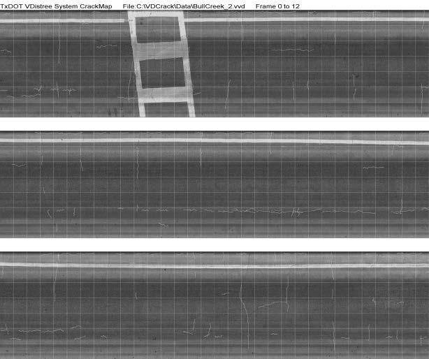
19 Crack map

20 Crack Map
21 All systems were developed by TxDOT 3-D development team: Dr. Robin Huang, Todd Copenhaver, Phillip Hempel, P.E. and others from Construction Division, Pavement and Material Branch under the leadership of branch manager Dr. Magdy Mikhail, P.E. Thank You!
3D TECHNOLOGY FOR PAVEMENT PRESERVATION
 3D TECHNOLOGY FOR PAVEMENT PRESERVATION Technical Discussion for WASHTO 2015 Magdy Mikhail, P.E. Robin Huang Todd Copenhaver Footer Text March 23, 2015 Date Capabilities of 3D Technology for Pavement Preservation
20. Security Classif. (of this page) Unclassified
 Unclassified") 1. Report No. FHWA/TX-13/0-6610-1 2. Government Accession No. 3. Recipient's Catalog No. 4. Title and Subtitle IMPACT OF CHANGES IN PROFILE MEASUREMENT TECHNOLOGY ON QA TESTING OF PAVEMENT SMOOTHNESS:
1. Report No. FHWA/TX-13/0-6610-1 2. Government Accession No. 3. Recipient's Catalog No. 4. Title and Subtitle IMPACT OF CHANGES IN PROFILE MEASUREMENT TECHNOLOGY ON QA TESTING OF PAVEMENT SMOOTHNESS:
Pavemetrics. Automatic detection of sealed cracks using images and 3D data. PAVEMETRICS Systems Inc.
 Automatic detection of sealed cracks using images and 3D data Vision Technology for Inspection of Transportation Infrastructures PAVEMETRICS Systems Inc. 150 Boulevard René-Lévesque Est, Suite 1820 Québec,
3D Laser Imaging for Pavement Survey at 60 mph and True 1mm Resolution
 3D Laser Imaging for Pavement Survey at 60 mph and True 1mm Resolution Kelvin C. P. Wang Oklahoma State University & WayLink kelvin.wang@okstate.edu 2013 Arizona Pavements/Materials Conference ASU MU,
Road Surface Texture Evaluation with 3-D Laser Data
 Road Surface Texture Evaluation with -D Laser Data Shuvo Islam 1, Mustaque Hossain, and Humaira Zahir ( 1 Kansas State University, Manhattan, KS, USA, sislam@ksu.edu) ( Kansas State University, Manhattan,
Pavement Surface Microtexture: Testing, Characterization and Frictional Interpretation
 Pavement Surface Microtexture: Testing, Characterization and Frictional Interpretation S h u o L i, S a m y N o u r e l d i n, K a r e n Z h u a n d Y i J i a n g Acknowledgements This project was sponsored
Current Investigations into the Effects of Texture on IRI RPUG Jareer Abdel-Qader, Emmanuel Fernando, Roger Walker
 Current Investigations into the Effects of Texture on IRI RPUG 28 Jareer Abdel-Qader, Emmanuel Fernando, Roger Walker Study Objectives Emmanuel s Presentation confirmed texture effects on IRI in both Laboratory
3D laser road profiling for the automated measurement of road surface conditions and geometry.
 3D laser road profiling for the automated measurement of road surface conditions and geometry. John Laurent 1, Jean François Hébert 1, Daniel Lefebvre 2, Yves Savard 3 1 Pavemetrics Systems inc., Canada
Georeferencing West Virginia DOT s Roadside Assets: An Asset Inventory Case Study. Geoff Dew April 13,
 : An Asset Inventory Case Study Geoff Dew April 13, 2010 General Project Scope 17,817 miles collected across all systems. System Type Delivered Miles 1 Interstates 1100.820 2 US Routes 2184.538 3 WV Routes
Statistical and Econometric Methods for Transportation Data Analysis
 Statistical and Econometric Methods for Transportation Data Analysis Chapter 14 Ordered Probability Models Example 14.2 Ordered Discrete Data Ordered Probit with Random Effects A survey of 56 subjects
Student Guide. Product P2. Validation of TxDOT Flexible Pavement Skid Prediction Model: Workshop
 Student Guide Product 0-6746-01-P2 Validation of TxDOT Flexible Pavement Skid Prediction Model: Workshop Published: May 2017 VALIDATION OF TXDOT FLEXIBLE PAVEMENT SKID PREDICTION MODEL: WORKSHOP by Arif
Introduction Texture/Friction Measurement at Winnipeg International Airport Data Analysis Conclusions
 Texture/Friction Measurements and Analysis at Runway 13-31 of James Armstrong Richardson International Airport in Winnipeg Qingfan Liu, EIT, PhD candidate, University of Manitoba Ahmed Shalaby, PhD, P.
20. Security Classification.(of this page) Unclassified
 Unclassified") Technical Report Documentation Page 1. Report No. FHWA/TX-09/0-6004-1 2. Government Accession No. 3. Recipient's Catalog No. 4. Title and Subtitle A PORTABLE PROFILER FOR PAVEMENT PROFILE MEASUREMENTS
Technical Report Documentation Page 1. Report No. FHWA/TX-09/0-6004-1 2. Government Accession No. 3. Recipient's Catalog No. 4. Title and Subtitle A PORTABLE PROFILER FOR PAVEMENT PROFILE MEASUREMENTS
Technical Report Documentation Page 2. Government 3. Recipient s Catalog No.
 . Report No. FHWA/TX-08/0-5708- Technical Report Documentation Page 2. Government 3. Recipient s Catalog No. Accession No. 4. Title and Subtitle Design of CrackScope (VCrack) [Reprint] 7. Author(s) Bugao
USING FULL LANE 3D ROAD TEXTURE DATA FOR THE AUTOMATED DETECTION OF SEALED CRACKS, BLEEDING AND RAVELING
 USING FULL LANE 3D ROAD TEXTURE DATA FOR THE AUTOMATED DETECTION OF SEALED CRACKS, BLEEDING AND RAVELING John Laurent 1, Jean François Hébert 1, Mario Talbot 1 1 Pavemetrics Systems Inc., Québec, Canada
Exploring Pavement Texture and Surface Friction Using Soft Computing Techniques
 Exploring Pavement Texture and Surface Friction Using Soft Computing Techniques Students: Guangwei Yang, You Zhan, Ace Fei, Allen Zhang PIs: Joshua Q. Li & Kelvin C.P. Wang School of Civil and Environmental
3D Mapping of Pavements: Geometry and DTM
 BUDAPEST, HUNGARY 2015 3D Mapping of Pavements: Geometry and DTM John Laurent, Pavemetrics inc. www.pavemetrics.com The Sensor Technology Most Relied-on by DOTs worldwide Collect Your Own, or Contract-out
Profilograph. Changes in Profiling Technology
 Profilograph Changes in Profiling Technology Lightweight Profiler High Speed Profiler 1 How Does It Work? Lightweight Profiler Laser Sensor 2 The Laser Sensor! Laser samples the pavement 16,000/sec! Samples
CASE 1 TWO LANE TO FOUR LANE DIVIDED TRANSITION GEO-610-C NOT TO SCALE GEOMETRIC DESIGN GUIDE FOR MATCH LINE LINE MATCH. 2 (0.6m) shoulder transition
 shoulder transition") CASE 1 2 (0.6m) Joint Line See sheet #5 for description of variables 4 (1.2m) Transition taper is tangent to Edge of Pavement curve at this point. 1:25 Paved shoulder transition 16 (4.m) Median width 16
CASE 1 2 (0.6m) Joint Line See sheet #5 for description of variables 4 (1.2m) Transition taper is tangent to Edge of Pavement curve at this point. 1:25 Paved shoulder transition 16 (4.m) Median width 16
Hot-Mix Asphalt and Flexible Pavement Design: the MEPDG
 Hot-Mix Asphalt and Flexible Pavement Design: the MEPDG Kevin D. Hall, Ph.D., P.E. Professor and Head, Dept. of Civil Engineering University of Arkansas Flexible Pavement Research Symposium Denver, Colorado
OPTIMIZING 3D SURFACE CHARACTERISTICS DATA COLLECTION BY RE-USING THE DATA FOR PROJECT LEVEL ROAD DESIGN
 OPTIMIZING 3D SURFACE CHARACTERISTICS DATA COLLECTION BY RE-USING THE DATA FOR PROJECT LEVEL ROAD DESIGN Benoit Petitclerc, P.E. John Laurent, M. Sc Richard Habel, M. Sc., Pavemetrics Systems Inc., Canada
Detecting and Correcting Localized Roughness Features
 0 0 Detecting and Correcting Localized Features Gary J. Higgins Earth Engineering Consultants, LLC Greenfield Drive Windsor, Colorado 00 Tel: 0--0; Fax: 0--0; Email: garyh@earth-engineering.com Word count:,
Squirm and lateral Wander in Certain Textures
 Squirm and lateral Wander in Certain Textures A Case Study of Diagnosis and Mitigation Bernard Igbafen Izevbekhai, P.E., Ph.D. MnDOT Research Operations Engineer Research Pays Off Seminar Series March
I-96 Case Study: Jointed Concrete Pavement Curling and Warp Presented in the Context of Pavement Asset Management
 I-96 Case Study: Jointed Concrete Pavement Curling and Warp Presented in the Context of Pavement Asset Management Christopher R. Byrum, PhD, PE PAVEMENT ANALYSIS: Soil-Structure Interaction Engineering
DEVELOPMENT AND IMPLEMENTATION OF PAVEMENT CONDITION INDICES FOR THE VIRGINIA DEPARTMENT OF TRANSPORTATION PHASE I FLEXIBLE PAVEMENTS
 DEVELOPMENT AND IMPLEMENTATION OF PAVEMENT CONDITION INDICES FOR THE VIRGINIA DEPARTMENT OF TRANSPORTATION PHASE I FLEXIBLE PAVEMENTS By K. H. McGhee Pavement Consultant September 2002 TABLE OF CONTENTS
Distress Image Library for Precision and Bias of Fully Automated Pavement Cracking Survey
 Distress Image Library for Precision and Bias of Fully Automated Pavement Cracking Survey Kelvin C.P. Wang, Ran Ji, and Cheng Chen kelvin.wang@okstate.edu Oklahoma State University/WayLink School of Civil
James L. Brown, Larry J. Buttler and William P. Ezzell
 ~.,_~w._'''... SURVEY OF STRUCTURAL FAILURES IN A CONTINUOUSLY REINFORCED CONCRETE PAVEMENT By James L. Brown, Larry J. Buttler and William P. Ezzell Special Study No.. Highway Design Division, Research
PAVEMENT PROFILE SCANNER +
 PAVEMENT PROFILE SCANNER + NEXT GENERATION IN ROAD MONITORING, MODELLING AND MAPPING MADRID 2018 Contents ABOUT LEHMANN+PARTNER PAVEMENT PROFILE SCANNER + DATA PRODUCTS AND ANALYSIS LATEST RESEARCH AND
Reliability of Results Depends On:
 HDM-4 Calibration Reliability of Results Depends On: How well the available data represent the real conditions to HDM How well the model s predictions fit the real behaviour and respond to prevailing conditions
Pathway Services Inc. Technology Presentation
 Lauren Tran Budapest, Hungary 2015 Largest Vendor of this kind in the U.S. Largest Fleet of Full Service Vehicles in U.S. (26) More Than 5 Million Kilometers Collected Using Our Equipment Nearly 50% of
CS8800 WALKING PROFILER
 CS8800 WALKING PROFILER Overview CS8800 Design and Measurement Method Operational Procedures Recent and Pending Enhancements Base Price & Options Comments on October 20009 FHWA Collections CS8800 DESIGN
Recent Innovations in the Management of Irish National Roads
 Recent Innovations in the Management of Irish National Roads Dr. Kieran Feighan PMS Ray McGowan PMS Tom Casey NRA (Ireland) Andrew O Sullivan NRA (Ireland) NRA Pavement Management System dtims version
PAVE-IR OPERATOR S MANUAL. Version 1.2
 PAVE-IR OPERATOR S MANUAL Version 1.2 A Thermal Imaging System for Evaluating Hot-Mix Asphalt Paving Operations by Stephen Sebesta, Tom Scullion, P.E., Wenting Liu, P.E., and Gerry Harrison Product 5-4577-01-P3
Instructions for Using the PMIS MapZapper. Version 3.400
 Instructions for Using the PMIS MapZapper Version 3.400 October 3, 2005 What s New in Version 3.400? Makes maps of one or more districts, one or more counties, one or more maintenance sections, one or
A New Rutting Measurement Method Using Emerging 3D Line-Laser-Imaging System
 Technical Paper ISSN 1997-1400 Int. J. Pavement Res. Technol. 6(5):667-672 Copyright @ Chinese Society of Pavement Engineering A New Rutting Measurement Method Using Emerging 3D Line-Laser-Imaging System
Noncontact Pavement Crack Detection System
 TRANSPORTATION RESEARCH RECORD 1311 149 Noncontact Pavement Crack Detection System ROGERS. WALKER AND ROBERT L. HARRIS A system has been developed for the Texas State Department of Highways and Public
PE Exam Review - Surveying Demonstration Problem Solutions
 PE Exam Review - Surveying Demonstration Problem Solutions I. Demonstration Problem Solutions... 1. Circular Curves Part A.... Circular Curves Part B... 9 3. Vertical Curves Part A... 18 4. Vertical Curves
ROAD SURFACE STRUCTURE MONITORING AND ANALYSIS USING HIGH PRECISION GPS MOBILE MEASUREMENT SYSTEMS (MMS)
") ROAD SURFACE STRUCTURE MONITORING AND ANALYSIS USING HIGH PRECISION GPS MOBILE MEASUREMENT SYSTEMS (MMS) Bonifacio R. Prieto PASCO Philippines Corporation, Pasig City, 1605, Philippines Email: bonifacio_prieto@pascoph.com
ROAD SURFACE STRUCTURE MONITORING AND ANALYSIS USING HIGH PRECISION GPS MOBILE MEASUREMENT SYSTEMS (MMS) Bonifacio R. Prieto PASCO Philippines Corporation, Pasig City, 1605, Philippines Email: bonifacio_prieto@pascoph.com
CALIBRATION OF LASER DEVICES USED FOR THE MEASUREMENT OF PAVEMENT SURFACE TEXTURE: ACCURACY OF PAVEMENT TEXTURE MEASUREMENT
 CALIBRATION OF LASER DEVICES USED FOR THE MEASUREMENT OF PAVEMENT SURFACE TEXTURE: ACCURACY OF PAVEMENT TEXTURE MEASUREMENT Darren Holloway, Department for Transport, Energy and Infrastructure, Australia
FIELD OPERATION CENTER Coastal Hydraulics Lab. Field Data Collection and Analysis Branch Our Team Members
 FIELD OPERATION CENTER Coastal Hydraulics Lab Field Data Collection and Analysis Branch Our Team Members Mobile/Static LIDAR and Photogrammetry Platforms and Equipment Mobile/Static LIDAR and Photogrammetry
Measurement and analysis of inhomogeneity in asphalt pavements
 Measurement and analysis of inhomogeneity in asphalt pavements Erik Espe Viatech AS, Kongsberg, Norway Leif Jørgen Bakløkk Norwegian Public Roads Administration, Trondheim, Norway ABSTRACT: This paper
Development and evaluation of an inertial based pavement roughness measuring system
 University of South Florida Scholar Commons Graduate Theses and Dissertations Graduate School 2006 Development and evaluation of an inertial based pavement roughness measuring system Fengxuan Hu University
Use of 3D modelling techniques to better understand road surface textures
 Use of 3D modelling techniques to better understand road surface textures David Woodward, Phillip Millar and Grainne McQuaid Highway Engineering Research Group University of Ulster Road surface textures
Development of Warm Mix Asphalt Policies and Specifications in Minnesota
 Development of Warm Mix Asphalt Policies and Specifications in Minnesota Tim Clyne, Greg Johnson, John Garrity MnDOT 2 nd International Warm Mix Conference October 13, 2011 Acknowledgements MnDOT Greg
A METHODOLOGY FOR CHARACTERIZING PAVEMENT RUTTING CONDITION USING EMERGING 3D LINE LASER IMAGING TECHNOLOGY
 A METHODOLOGY FOR CHARACTERIZING PAVEMENT RUTTING CONDITION USING EMERGING 3D LINE LASER IMAGING TECHNOLOGY A Dissertation Presented to The Academic Faculty by Feng Li In Partial Fulfillment of the Requirements
Developing New Methods for the Automatic Measurement of Raveling at Traffic-Speed
 Developing New Methods for the Automatic Measurement of Raveling at Traffic-Speed S. McRobbie, A. Wright & J. Iaquinta Technology Development & Quality Assurance Group, Infrastructure Division, TRL Ltd,
3D Milling. Tom Abell
 3D Milling Tom Abell Trimble & 3D Milling as Part of the Resurfacing Process Design Measure Resurfacing From initial survey to finish surface Mill Compact Pave Content Data acquisition Creating data models
ABOUT THE REPRODUCIBILITY OF TEXTURE PROFILES AND THE PROBLEM OF SPIKES
 ABOUT THE REPRODUCIBILITY OF TEXTURE PROFILES AND THE PROBLEM OF SPIKES ABSTRACT L. GOUBERT & A. BERGIERS Belgian Road Research Centre, Belgium L.GOUBERT@BRRC.BE The ISO working group ISO/TC43/SC1/WG39
Multi-Speed Deflectometer. An innovative tool for local authority network asset management
 Multi-Speed Deflectometer An innovative tool for local authority network asset management What is the MSD? Falling Weight Deflectometer The Multi-Speed Deflectometer (MSD) is a new, innovative technique
Pavement Preservation and the Role of Bituminous Surface Treatments A Washington State View. Minnesota Pavement Conference February 14, 2008
 Pavement Preservation and the Role of Bituminous Surface Treatments A Washington State View Minnesota Pavement Conference February 14, 2008 1 The Situation 2 WSDOT policy, in essence, mandated use of BSTs
Mining and Analysis of Traffic Safety and Roadway Condition Data
 Mining and Analysis of Traffic Safety and Roadway Condition Data Hong Lin (linh@itsc.uah.edu) Sudheer Cheedella (cheedes@email.uah.edu) John Rushing (jrushing@itsc.uah.edu) Michael Anderson (mikea@cee.uah.edu)
Technical Report Documentation Page 2. Government Accession No. 3. Recipient's Catalog No. 1. Report No. FHWA/TX-12/
 1. Report No. FHWA/TX-12/5-5597-01-1 4. Title and Subtitle LABORATORY AND FIELD PERFORMANCE MEASUREMENTS TO SUPPORT THE IMPLEMENTATION OF WARM MIX ASPHALT IN TEXAS Technical Report Documentation Page 2.
ProVAL. User s Guide Version 2.73
 ProVAL User s Guide Version 2.73 ProVAL User s Guide Version 2.73 Manual Revision: 1.30 (2.73) Written by Dr. George K. Chang, P.E.; Mr. Jason C. Dick; and Dr. Robert Otto Rasmussen, P.E. Copyright 2001-2007
Smoothness of Pavement in Weighin-Motion
 Standard Specification for Smoothness of Pavement in Weighin-Motion (WIM) Systems AASHTO Designation: MP 14-05 American Association of State Highway and Transportation Officials 444 North Capitol Street
KEEPING DATA ACCURATE WITH THE DUSA APPLICATION
 KEEPING DATA ACCURATE WITH THE DUSA APPLICATION Jenn Sylvester, Mapping Branch Team Lead Adam Breznicky, Mapping Branch Web Master Transportation Planning & Programming Division (TPP) ESRI International
AN ABSTRACT OF THE THESIS OF
 AN ABSTRACT OF THE THESIS OF Abby Chin for the degree of Master of Science in Civil Engineering presented on May 8, 2012. Title: Paving the Way for Terrestrial Laser Scanning Assessment of Road Quality
A New Way to Control Mobile LiDAR Data
 A New Way to Control Mobile LiDAR Data Survey control has always been a critically important issue when conducting mobile LiDAR surveys. While the accuracies currently being achieved with the most capable
Detection, Classification, Evaluation and Compression of Pavement Information
 Detection, Classification, Evaluation and Compression of Pavement Information S.Vishnu Kumar Maduguri Sudhir Md.Nazia Sultana Vishnu6soma@Gmail.Com Sudhir3801@Gmail.Com Mohammadnazia9@Gmail.Com ABSTRACT
Future Federal Aviation Administration (FAA) Developments of Roughness Evaluation for In-Service Airport Pavement
 Developments of Roughness Evaluation for In-Service Airport Pavement") Future (FAA) Developments of Roughness Evaluation for In-Service Airport Pavement Presented to: 2018 European Road Profile Users Group Madrid, Spain By: Albert Larkin, FAA Airport Pavement R & D, Dr. B.
Future (FAA) Developments of Roughness Evaluation for In-Service Airport Pavement Presented to: 2018 European Road Profile Users Group Madrid, Spain By: Albert Larkin, FAA Airport Pavement R & D, Dr. B.
A FEASIBILITY STUDY ON USE OF GENERIC MOBILE LASER SCANNING SYSTEM FOR DETECTING ASPHALT PAVEMENT CRACKS
 A FEASIBILITY STUDY ON USE OF GENERIC MOBILE LASER SCANNING SYSTEM FOR DETECTING ASPHALT PAVEMENT CRACKS Xinqu Chen a, Jonathan Li a* a Mobile Sensing and Geodata Science Lab, Department of Geography and
Form DOT F (8-72) Technical Report Documentation Page 2. Government Accession No. 3. Recipient's Catalog No.
 Technical Report Documentation Page 2. Government Accession No. 3. Recipient's Catalog No.") 1. Report No. FHWA/TX-09/5-4577-03-P1 4. Title and Subtitle PAVE-IR OPERATOR S MANUAL VERSION 1.3 Technical Report Documentation Page 2. Government Accession No. 3. Recipient's Catalog No. 5. Report Date
1. Report No. FHWA/TX-09/5-4577-03-P1 4. Title and Subtitle PAVE-IR OPERATOR S MANUAL VERSION 1.3 Technical Report Documentation Page 2. Government Accession No. 3. Recipient's Catalog No. 5. Report Date
Cross Slope Collection using Mobile Lidar
 Cross Slope Collection using Mobile Lidar ACEC/SCDOT Annual Meeting December 2, 2015 Introduction Adequate cross slopes on South Carolina Interstates result in: Proper drainage Enhance driver safety by
DARWIN-ME Pavement Analysis and Design Manual for NJDOT
 2012 DARWIN-ME Pavement Analysis and Design Manual for NJDOT Book 1 Pavement Overview, Traffic and Climatic Inputs Vitillo, Nicholas Rutgers - CAIT Pavement Resource Program 1 4/1/2012 Darwin ME Flexible
Sight Distance on Vertical Curves
 Iowa Department of Transportation Office of Design Sight Distance on Vertical Curves 6D-5 Design Manual Chapter 6 Geometric Design Originally Issued: 01-04-0 Stopping sight distance is an important factor
GEOMETRIC EVALUATION OF ROAD SIGNS USING RADIOMETRIC INFORMATION FROM LASER SCANNING DATA
 GEOMETRIC EVALUATION OF ROAD SIGNS USING RADIOMETRIC INFORMATION FROM LASER SCANNING DATA Higinio González-Jorge*, Belén Riveiro, Julia Armesto, and P. Arias Department of Natural Resources and Environmental
Modeling Real-Time Tolapai Based Embedded System using MARTE
 Modeling Real-Time Tolapai Based Embedded System using MARTE JAREER H. ABDEL-QADER Department of Computer Science and Engineering University of Texas at Arlington 416 Yates St. Nedderman Hall, Rm 300,
Characterization of Aggregate Texture and Correlation with Surface Skid Resistance
 TECHNICAL REPORT 0-6878-3 TxDOT PROJECT NUMBER 0-6878 Characterization of Aggregate Texture and Correlation with Surface Skid Resistance Sareh Kouchaki Hossein Roshani Joaquin Bernardo Hernandez Jorge
SURFACE POTHOLE DEPTH ESTIMATION USING STEREO MODE OF IMAGE PROCESSING Vijaya Bashkar. A 1, Gowri Manohar. T 2
 SURFACE POTHOLE DEPTH ESTIMATION USING STEREO MODE OF IMAGE PROCESSING Vijaya Bashkar. A 1, Gowri Manohar. T 2 1 Department of Electrical and Electronics Engineering, SVU College of Engineering, Tirupati-517501,
FRICTION TESTING KJ LAW (DYNATEST) SKID TRAILER
 SKID TRAILER") Version 1 June 2009 FRICTION TESTING KJ LAW (DYNATEST) SKID TRAILER General Description Pavement surface friction is regarded as an indicator of safety of vehicles on highways because it is a measure of
Version 1 June 2009 FRICTION TESTING KJ LAW (DYNATEST) SKID TRAILER General Description Pavement surface friction is regarded as an indicator of safety of vehicles on highways because it is a measure of
Mobile LiDAR in Road Surface Quality Control and Renovation - Latest Development of Terrasolid Software
 Geodesy, Mine Survey and Aerial Topography. At the turn of the centuries. Moscow 14 15 February 2013 Mobile LiDAR in Road Surface Quality Control and Renovation - Latest Development of Terrasolid Software
inspiring innovative Infratech Jyväskylä infra3d unique simplify 12 May 2017 Manuel Dätwyler Product Management infra3d
 inspiring Infratech Jyväskylä infra3d 12 May 2017 Manuel Dätwyler Product Management infra3d simplify unique innovative What s the issue? «cost-intensive infrastructure management» 2 What are yours subjects
FRICTION TESTING KJ LAW (DYNATEST) SKID TRAILER
 SKID TRAILER") Version 3 November 2016 FRICTION TESTING KJ LAW (DYNATEST) SKID TRAILER General Description Pavement surface friction is regarded as an indicator of safety of vehicles on highways because it is a measure
Version 3 November 2016 FRICTION TESTING KJ LAW (DYNATEST) SKID TRAILER General Description Pavement surface friction is regarded as an indicator of safety of vehicles on highways because it is a measure
MICHIGAN DEPARTMENT OF TRANSPORTATION SPECIAL PROVISION FOR MICROWAVE VEHICLE DETECTION SYSTEM
 MICHIGAN DEPARTMENT OF TRANSPORTATION SPECIAL PROVISION FOR MICROWAVE VEHICLE DETECTION SYSTEM ITS:CLC 1 of 5 APPR:JVG:DBP:06-29-17 FHWA:APPR:08-02-17 a. Description. This work consists of one or more
Control System International a.s., Papírenská 114/5, Praha 6, Czech Republic Web site: www. controlsystem.cz,
 129 Consequences of a complex using of 3D approach in the implementation of the road reconstruction - usage of TLS stop&go and usage of paving control system for milling machines Přikryl, M. and Kutil,
Jeffrey A. Schepers P.S. EIT Geospatial Services Holland Engineering Inc. 220 Hoover Blvd, Suite 2, Holland, MI Desk
 Jeffrey A. Schepers P.S. EIT Geospatial Services Holland Engineering Inc. 220 Hoover Blvd, Suite 2, Holland, MI 49423 616-594-5127 Desk 616-322-1724 Cell 616-392-5938 Office Mobile LiDAR - Laser Scanning
AUTOMATIC DETECTION AND CLASSIFICATION OF DEFECT ON ROAD PAVEMENT USING ANISOTROPY MEASURE
 17th European Signal Processing Conference (EUSIPCO 2009) Glasgow, Scotland, August 24-28, 2009 AUTOMATIC DETECTION AND CLASSIFICATION OF DEFECT ON ROAD PAVEMENT USING ANISOTROPY MEASURE Tien Sy NGUYEN(1)(2),
Polymer-Modified Asphalts Enhancing HMA Performance. New Orleans, Louisiana January 28, 2003
 Polymer-Modified Asphalts Enhancing HMA Performance New Orleans, Louisiana January 28, 2003 Presentation Overview 1. Introduction 2. Phase I Overview 3. Summary of Interim Results & Findings Study Objectives
ACAF Paving Electronics (Today and Future) TOPCON POSITIONING SYSTEMS / LENGEMANN CORPORATION TRIMBLE NAVIGATION / SITECH NORTH, CENTRAL FLORIDA
 TOPCON POSITIONING SYSTEMS / LENGEMANN CORPORATION TRIMBLE NAVIGATION / SITECH NORTH, CENTRAL FLORIDA") ACAF 2016 ROGER CROFT GREG HASTY TOPCON POSITIONING SYSTEMS / LENGEMANN CORPORATION TRIMBLE NAVIGATION / SITECH NORTH, CENTRAL FLORIDA 2D & 3D Machine Control ROGER CROFT TOPCON POSITIONING SYSTEMS / LENGEMANN
ACAF 2016 ROGER CROFT GREG HASTY TOPCON POSITIONING SYSTEMS / LENGEMANN CORPORATION TRIMBLE NAVIGATION / SITECH NORTH, CENTRAL FLORIDA 2D & 3D Machine Control ROGER CROFT TOPCON POSITIONING SYSTEMS / LENGEMANN
OCTOBER OTEC Session 75 Stringless 3D Paving
 OCTOBER 03 2018 OTEC Session 75 Stringless 3D Paving Introductions Brian E Girouard, Trimble Inc Sales Engineer Paving Specialist Manager brian_girouard@trimble.com Brad Cunningham, SITECH Ohio SITECH
RAIL HIGHWAY GRADE CROSSING ROUGHNESS QUANTITATIVE MEASUREMENT USING 3D TECHNOLOGY
 RAIL HIGHWAY GRADE CROSSING ROUGHNESS QUANTITATIVE MEASUREMENT USING 3D TECHNOLOGY Teng (Alex) Wang, Reginald Souleyrette& Jerry Rose University of Kentucky Lexington, KY Introduction Background: - highway-rail
Automatic Detection of Pavement Surface Defects Using Consumer Depth Camera. Chenxi YUAN 1 and Hubo CAI 2
 974 Automatic Detection of Pavement Surface Defects Using Consumer Depth Camera Chenxi YUAN 1 and Hubo CAI 2 1 Graduate student, Division of Construction Engineering & Management, School of Civil Engineering,
DEVELOPMENT OF A PROCEDURE FOR ROUTE SEGMENTATION USING PREDICTED LAYER THICKNESSES FROM RADAR MEASUREMENTS
 DEVELOPMENT OF A PROCEDURE FOR ROUTE SEGMENTATION USING PREDICTED LAYER THICKNESSES FROM RADAR MEASUREMENTS FLORIDA DOT STATE PROJECT 99700-7550, PHASE 2A FINAL REPORT PREPARED BY: EMMANUEL G. FERNANDO,
Software and Hardware improvements using 1mm x 1mm resolution 3D road surface data
 Software and Hardware improvements using 1mm x 1mm resolution 3D road surface data By John Laurent Pavemetrics Systems inc. www.pavemetrics.com 30 years on the Road To Progressively Better Data Pavemetrics:
Experiences of integrated GPR and Laser Scanner analysis We should not only look down but also around
 NGM 2016 Reykjavik Proceedings of the 17 th Nordic Geotechnical Meeting Challenges in Nordic Geotechnic 25 th 28 th of May Experiences of integrated GPR and Laser Scanner analysis We should not only look
Transportation Informatics: An Image Analysis System for Managing Transportation Facilities Phase II
 Transportation Informatics: An Image Analysis System for Managing Transportation Facilities Phase II The University of Toledo University Transportation Center Final Report Eddie Y. Chou Principal Investigator
LIDAR BASED BRIDGE EVALUATION PH.D DEFENSE - WANQIU LIU. Advisor: Dr. Shen-en Chen
 LIDAR BASED BRIDGE EVALUATION PH.D DEFENSE - WANQIU LIU Advisor: Dr. Shen-en Chen Acknowledgement Dr. Edd Hauser Dr. Gary Teng Dr. Srinivas Pulugurtha Dr. Jing Zhou USDOT-RiTA Project No. DTOS59-07-H-0005
Speed Limit and Safety Nexus Studies for Automated Enforcement Locations in the District of Columbia DC Miles South of Pennsylvania Avenue SE
 Speed Limit and Safety Nexus Studies for Automated Enforcement Locations in the District of Columbia DC 295.4 Miles South of Pennsylvania Avenue SE Study Area and Location District PSA Ward ANC Phase Description
Submitted for to the 2015 Transportation Research Board Conference for Presentation and Publication
 0 0 ROUGHNESS INDEX MEASURED WITH LINE LASER AND TRIPLE POINT LASER IN TEXTURED AND NON-TEXTURED STRIPS By Bernard Igbafen Izevbekhai, P.E., Ph.D. Corresponding Author Research Operations Engineer Minnesota
Deliverable D8.5 Video Showcase
 DOCUMENT Deliverable Number D8.5 Due Date 31/05/2016 Issued by WP/Task WP8/T8.5 Actual Date 18/07/2016 Dissemination Level PUBLIC Pages 17 Appendices one PROJECT Grant Agreement No. 606645 Acronym RPB
Mailbox Installation and Damage Replacement Policy
 Mailbox Installation and Damage Replacement Policy Mailboxes represent obstructions within road right-of-way and hazards to the traveling public and the Lawrence County Engineer encourages mailbox installations
Review and Analysis of Pothole Detection Methods 1
 Review and Analysis of Pothole Detection Methods 1 Taehyeong Kim *, 2 Seung-Ki Ryu 1 Senior Researcher, Korea Institute of Civil Engineering and Building Technology, Korea (*corresponding author) 2 Research
Surveys and Maps for Drainage Design
 Surveys and Maps for Drainage Design SURVEY TYPES BENCH LEVEL Survey Used to determine the elevation of a point (1-D) PROFILE Survey Used to determine the elevations of a line (2-D) TOPOGRAPHIC Survey
20. Security Classif. (of this page) Unclassified
 Unclassified") Technical Report Documentation Page 1. Report No. FHWA/TX-05/0-1778-3 2. Government Accession No. 3. Recipient s Catalog No. 4. Title and Subtitle ACCESSING THE RIGID PAVEMENT DATABASE THROUGH MICROSOFT
Technical Report Documentation Page 1. Report No. FHWA/TX-05/0-1778-3 2. Government Accession No. 3. Recipient s Catalog No. 4. Title and Subtitle ACCESSING THE RIGID PAVEMENT DATABASE THROUGH MICROSOFT
Main new features of Road Doctor 3.2
 Main new features of Road Doctor 3.2 Point Cloud Using the point clouds is easier than ever before in Road Doctor. All the default settings for major use purposes can now be selected from the defaults
COMMISSION POLICY POLICY #9.16
 COMMISSION POLICY POLICY #9.16 SUBJECT: Public Right-of-Way Encroachments and Regulations for Mailboxes and Newspaper Delivery Boxes DATE ADOPTED PAGE (BCC MINUTES) February 19, 2008 Page 26 OBSOLETE VERSIONS
Kevin Garcia and Brian Girouard February Machine Control Technology in Milling and Paving
 Kevin Garcia and Brian Girouard February 2017 Machine Control Technology in Milling and Paving Brian E Girouard, Milling Paving Compaction Specialist Civil Engineering & Construction Americas Trimble Navigation
MICHIGAN DEPARTMENT OF TRANSPORTATION SPECIAL PROVISION FOR MICROWAVE VEHICLE DETECTION SYSTEM
 MICHIGAN DEPARTMENT OF TRANSPORTATION SPECIAL PROVISION FOR MICROWAVE VEHICLE DETECTION SYSTEM ITS:CLC 1 of 6 APPR:LWB:DBP:07-31-13 FHWA:APPR:09-23-13 a. Description. This work consists of one or more
SAFETY ON THE IH 35 EXPANSION PROJECTS. Andy Petter, P.E. - Waco District
 SAFETY ON THE IH 35 EXPANSION PROJECTS Andy Petter, P.E. - Waco District Presentation IH 35 Expansion through the Waco District Safety Requirements on the Projects IH 35 Safety Summit Meetings Crash Data
Canadian Journal of Civil Engineering. Another Look at Delineation of Uniform Pavement Sections Based on FWD Deflections Data
 Another Look at Delineation of Uniform Pavement Sections Based on FWD Deflections Data Journal: Manuscript ID cjce-2015-0281.r1 Manuscript Type: Article Date Submitted by the Author: 18-Sep-2015 Complete
The Design of Road Evaluation and Monitoring System based on Geographical Information System
 The Design of Road Evaluation and Monitoring System based on Geographical Information System Ary Setyawan 1,*, Muhammad Farid Al Alimi 2, Dewi Handayani 2, Agus Sumarsono 1 1 Roadmate Research Group, Universitas