Recent Innovations in the Management of Irish National Roads
|
|
|
- Ethan Armstrong
- 5 years ago
- Views:
Transcription
1 Recent Innovations in the Management of Irish National Roads Dr. Kieran Feighan PMS Ray McGowan PMS Tom Casey NRA (Ireland) Andrew O Sullivan NRA (Ireland)
2 NRA Pavement Management System dtims version 8 (now v.9) Implemented in 2011/2012 improvements ongoing Data Repository Location Referencing System Condition Data Structure Data Age Surface Type Traffic Maintenance History
3 Corporate GIS Network Definition Summary Condition Data Mapping Data Strategic Modelling Tool Forecast Network Condition Network Updates PMS Data Repository Call-off 2 Forecast Budget Needs Condition Surveys Location Referencing Pavement Inventory Pavement Condition Data Data Analysis & Reporting Maintenance History Programming Tool Call-off 3 Multi-year Programmes Current Year Budget Allocations Candidate Scheme Lengths Scheme Level Analysis National Maintenance System Pavement Inventory Maintenance History Unit Rates
4 Georeferenced Data ESRI ArcGIS is at the centre of all management systems in NRA All data collected is georeferenced and mapped to new Location Referencing System (LRS) defined in 2012 Every video frame is georeferenced, all stored in cloud and on NRA servers (optimised for cloud access) Android apps developed for access and portability of video Plug-in app for video viewing within ArcGIS


5 Data-Transfer Tool 5
6 PMS Network Surveys Full network 1 direction each year Skid Resistance Ride Quality (IRI) Macrotexture Rut Depth Geometrics Video

7

8 RSP-General View
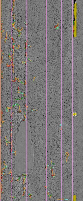
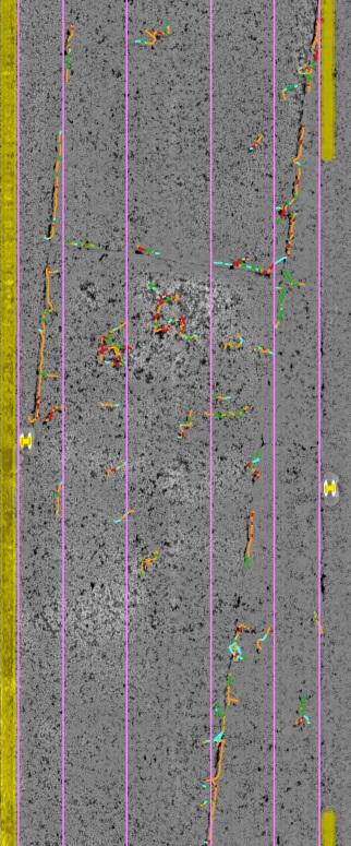
9 Network Surveys post 2012 Crack Detection Crack Types and widths Ravelling Detailed Cross section (4000 points, 1mm accuracy) Ground Penetrating Radar (pavement thickness)

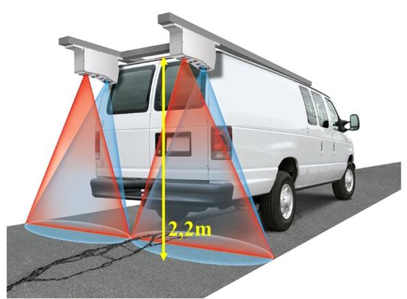
10 LCMS Laser Crack Measurement System
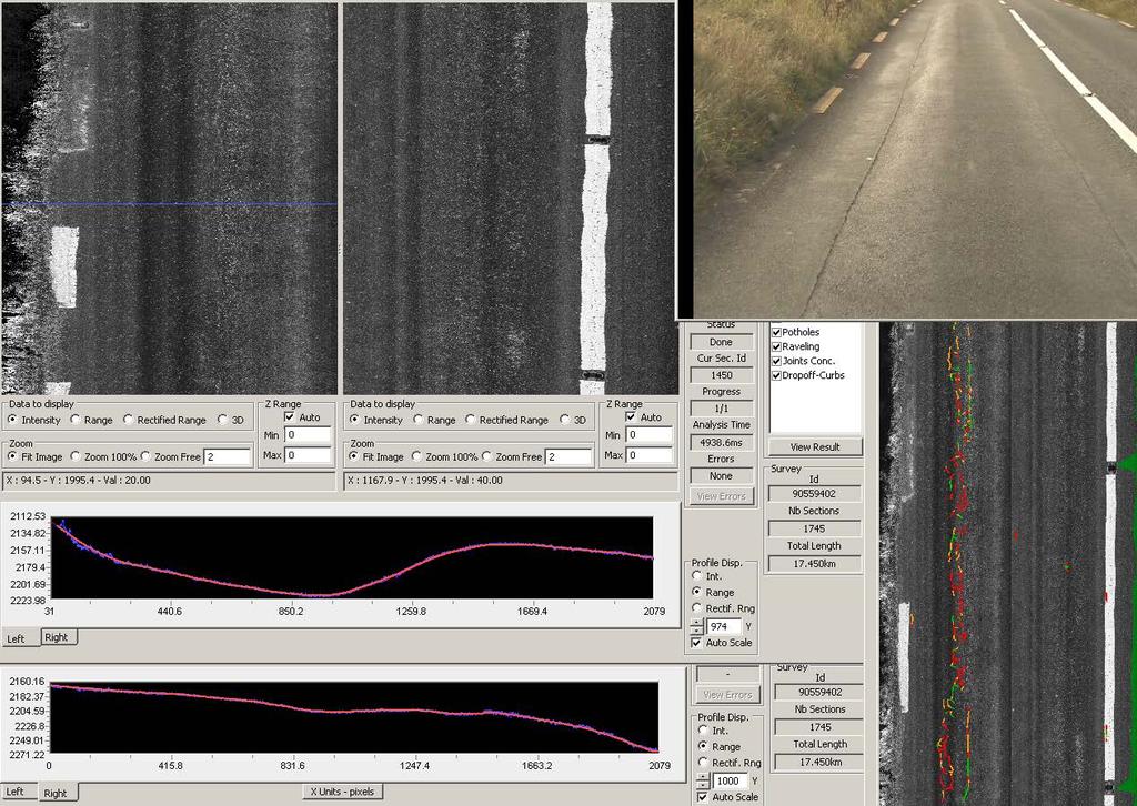
11 LCMS


12
13 Sub-networks National network is not homogeneous. Ranges from brand new fully engineered motorway to legacy pavements Management of the network needs to recognise this variability in order to manage intelligently Concept of Sub-networks introduced to address this
14 Sub-networks Network is either Engineered or Non- Engineered/Legacy Engineered pavements divided into Motorway/Dual Carriageway or Single Carriageway Legacy pavement network divided into High, Moderate and Low traffic


15

16
17
18 Sub-networks Practical Implications Different Allowable Levels of service i.e. Different definitions of Very Good/Good/Fair etc IRI Category Subnet 0 Subnet 1 Subnet 2 Subnet 3 Subnet 4 V Poor >3 >3.5 > 5 > 5 >7 Poor 2.5 to 3 3 to to 5 4 to 5 5 to 7 fair 2 to to to to 4 4 to 5 Good 1.5 to 2 2 to to to to 4 V. Good <1.5 <2 <2.7 <2.7 <3 Rut Depth Category Subnet 0 Subnet 1 Subnet 2 Subnet 3 Subnet 4 V Poor >9 >9 > 15 > 15 >20 Poor 6 to 9 6 to 9 9 to 15 9 to to 20 fair 5 to 6 5 to 6 6 to 9 6 to 9 9 to 15 Good 3 to 5 3 to 5 4 to 6 4 to 6 6 to 9 V. Good <3 <3 < 4 < 4 < 6 LPV3 Category Subnet 0 Subnet 1 Subnet 2 Subnet 3 Subnet 4 V Poor > 4 > 5 > 6 > 7 > 10 Poor 3 to 4 4 to 5 4 to 6 5 to 7 7 to 10 fair 2 to 3 3 to 4 3 to to 5 4 to 7
19 Sub-networks Practical Implications Different deterioration model parameters a b A b a Annual monitoring of overlay scheme locations allow models to be updated to reflect real deterioration rates
20 Sub-networks Practical Implications Different trigger values for treatments Treatments are triggered on maintenance sections when two or more parameters becomes Poor or Very Poor Parameter Subnet 0 Subnet 1 Subnet 2 Subnet 3 Subnet 4 IRI > 2.5 > 3 > 4 > 4 > 5 Rut > 6 > 6 > 9 > 9 > 15 LPV >3 >4 >4 >5 >7
21 Sub-networks Practical Implications Different Treatment Reset values Treatment Parameter Subnet Replace Surface (Relative Reset) Strengthen RD IRI LPV CSC RD IRI LPV CSC Annual monitoring allows reset values to be adjusted to reflect what is achievable on the ground Overlay schemes where target resets are not being achieved on site can be identified quickly Overlay Reconstruct RD IRI LPV CSC RD IRI LPV CSC
22 Pavement Works Programme Subnetwork Definitions Subnetwork Thresholds Percentage above Threshold (PAT) Prioritisation based on PATs Rolling 3 year programme developed Rutting, Ride Quality, Short Wavelength Cracking, Ravelling will be added
23 Percentage Above Threshold (PAT) IRI, Rut Depth, LPV3 (short wavelength) Example: Subnet 3, IRI poor threshold = 4 (250) 100m sample unit with IRI = 6, PAT = 100*(6-4)/4 = 50% Subnet 0, Rut Depth Poor threshold = 6 mm (0.25 inches) 100m sample unit with Rut Depth = 12 mm, PAT = 100*(12-6)/6 = 100%
24 Prioritisation using PAT 100m sample unit must have 2 parameters above threshold to be included PAT capped at 150% max for each parameter Sum of 2 highest PAT values is Representative PAT Much better correlation with local expert scheme selection when 2 PAT approach is used Combination of 100m PAT sample units into final schemes described in the paper Approach has been key to acceptance of PMS selected schemes over previous local bid system

25 Project Level Analysis and Prioritisation - dtims 25

26 Implementation in dtims 26

27


28


29
30 Management of Skid Resistance Division of network into sections/site categories Risk Equalisation Motorway mainline versus 2 lane road with tight radius bend Prioritisation of Investigation based on points below Threshold SCRIM machine used for Data
31 Site Categories and IL HD28/11 Site category and definition Investigatory Level at 50km/h A B C G1 G2 K Q R S1 S2 Motorway Dual carriageway non-event Single carriageway non-event Gradient 5-10% longer than 50m Gradient >10% longer than 50m Approaches to traffic signals. pedestrian crossings Approaches to and across major and minor junctions, Roundabout Bend radius <250m dual carriageway Bend radius <250m single carriageway Traffic > 250 commercial vehicles / lane/ per day Traffic < 250 commercial vehicles/lane/ per day

32 Site Inspection Site Location and Use Pavement Condition Data Collision Data Video Data All downloaded to tablet app

33
34 Summary Late Entrant able to leverage off advances in technology Everything fully geo-referenced GIS at centre of all management systems including PMS Cloud-based image storage and access Subnetwork definition crucial for active management PAT approach led to acceptance of centralised scheme selection Active Skid Resistance Management
35 Is it working?
36 PMI Expenditure 120 Millions ( ) Realignment Pavement Year
37
38

39
40
Multi-Speed Deflectometer. An innovative tool for local authority network asset management
 Multi-Speed Deflectometer An innovative tool for local authority network asset management What is the MSD? Falling Weight Deflectometer The Multi-Speed Deflectometer (MSD) is a new, innovative technique
Pathway Services Inc. Technology Presentation
 Lauren Tran Budapest, Hungary 2015 Largest Vendor of this kind in the U.S. Largest Fleet of Full Service Vehicles in U.S. (26) More Than 5 Million Kilometers Collected Using Our Equipment Nearly 50% of
New Technologies for Pavement Evaluation
 New Technologies for Pavement Evaluation TxDOT 3-D Pavement Survey Technology For 86 th Annual Transportation Short Course at Texas A&M University, 2012 Dr. Yaxiong (Robin) Huang, Robin.Huang@txdot.gov
Georeferencing West Virginia DOT s Roadside Assets: An Asset Inventory Case Study. Geoff Dew April 13,
 : An Asset Inventory Case Study Geoff Dew April 13, 2010 General Project Scope 17,817 miles collected across all systems. System Type Delivered Miles 1 Interstates 1100.820 2 US Routes 2184.538 3 WV Routes
Reliability of Results Depends On:
 HDM-4 Calibration Reliability of Results Depends On: How well the available data represent the real conditions to HDM How well the model s predictions fit the real behaviour and respond to prevailing conditions
Pavement Preservation and the Role of Bituminous Surface Treatments A Washington State View. Minnesota Pavement Conference February 14, 2008
 Pavement Preservation and the Role of Bituminous Surface Treatments A Washington State View Minnesota Pavement Conference February 14, 2008 1 The Situation 2 WSDOT policy, in essence, mandated use of BSTs
Road Surface Texture Evaluation with 3-D Laser Data
 Road Surface Texture Evaluation with -D Laser Data Shuvo Islam 1, Mustaque Hossain, and Humaira Zahir ( 1 Kansas State University, Manhattan, KS, USA, sislam@ksu.edu) ( Kansas State University, Manhattan,
PMB a performance based approach. Jasper van der Wal Ooms PMB The Netherlands
 PMB a performance based approach Jasper van der Wal Ooms PMB The Netherlands Jasper.vanderwal@ooms.nl A brief company introduction A brief company introduction Road construction Design & consultancy (roads)
NEW INDICATORS OF RIDING COMFORT BASED ON VEHICLE DYNAMICS. Pertti Virtala & Juho Meriläinen
 NEW INDICATORS OF RIDING COMFORT BASED ON VEHICLE DYNAMICS Pertti Virtala & Juho Meriläinen CONTENT Background Problem statement Methods Results Conclusions 2 BACKGROUND & PROBLEM Longitudinal unevenness
Developing New Methods for the Automatic Measurement of Raveling at Traffic-Speed
 Developing New Methods for the Automatic Measurement of Raveling at Traffic-Speed S. McRobbie, A. Wright & J. Iaquinta Technology Development & Quality Assurance Group, Infrastructure Division, TRL Ltd,
4.1 Identification of Potential Water Ponding 4.2 Monitoring of Road Inventory 4.3 Monitoring of surface condition
 TRIMM is supported by funding from the 7 th Framework Programme Call: SST.2011.5.2-2. Theme: Advanced and cost effective road infrastructure construction, management and maintenance Alex Wright 4.1 Identification
A New Direction in GIS Data Collection or Why Are You Still in the Field?
 GeoAutomation The Mobile Mapping System Survey-Enabled Imagery A New Direction in GIS Data Collection or Why Are You Still in the Field? Presentation to: URISA BC GIS Technology Showcase January 19, 2011
Essentials for professional use
 Road Surveys using smartphones Essentials for professional use June 2016 - App version 2.1.8- This guide gives a short introduction and briefly describes how to: 1. Collect road roughness data + auto photos
Transport Network ITS Spatial Data Deployment Platform
 Transport Network ITS Spatial Data Deployment Platform TN-ITS and JRS meeting 18 June 2014 The core concept (1/2) TN-ITS is about the exchange of static map information from the Road Sector, it is not
3D laser road profiling for the automated measurement of road surface conditions and geometry.
 3D laser road profiling for the automated measurement of road surface conditions and geometry. John Laurent 1, Jean François Hébert 1, Daniel Lefebvre 2, Yves Savard 3 1 Pavemetrics Systems inc., Canada
Measurement and analysis of inhomogeneity in asphalt pavements
 Measurement and analysis of inhomogeneity in asphalt pavements Erik Espe Viatech AS, Kongsberg, Norway Leif Jørgen Bakløkk Norwegian Public Roads Administration, Trondheim, Norway ABSTRACT: This paper
3D Laser Imaging for Pavement Survey at 60 mph and True 1mm Resolution
 3D Laser Imaging for Pavement Survey at 60 mph and True 1mm Resolution Kelvin C. P. Wang Oklahoma State University & WayLink kelvin.wang@okstate.edu 2013 Arizona Pavements/Materials Conference ASU MU,
The strive for a high quality road data base
 Swedish Road Administration 781 87 Borlänge SWEDEN Röda vägen 1 www.vv.se Telephone: +46 (0) 771 119 119 Thomas Norlin Road and traffic data thomas.norlin@vv.se Direct: +46 (0) 243 756 48 Mobile: +76 (0)761
Control System International a.s., Papírenská 114/5, Praha 6, Czech Republic Web site: www. controlsystem.cz,
 129 Consequences of a complex using of 3D approach in the implementation of the road reconstruction - usage of TLS stop&go and usage of paving control system for milling machines Přikryl, M. and Kutil,
inspiring innovative Infratech Jyväskylä infra3d unique simplify 12 May 2017 Manuel Dätwyler Product Management infra3d
 inspiring Infratech Jyväskylä infra3d 12 May 2017 Manuel Dätwyler Product Management infra3d simplify unique innovative What s the issue? «cost-intensive infrastructure management» 2 What are yours subjects
Converting the Roads & Highways Advanced LRS to a Routable Network. Eric J. Rodenberg
 Converting the Roads & Highways Advanced LRS to a Routable Network Eric J. Rodenberg Agenda The ArcGIS Platform Roads and Highways Network Datasets Roads and Highways Events Converting the LRS to a Network
LIDAR BASED BRIDGE EVALUATION PH.D DEFENSE - WANQIU LIU. Advisor: Dr. Shen-en Chen
 LIDAR BASED BRIDGE EVALUATION PH.D DEFENSE - WANQIU LIU Advisor: Dr. Shen-en Chen Acknowledgement Dr. Edd Hauser Dr. Gary Teng Dr. Srinivas Pulugurtha Dr. Jing Zhou USDOT-RiTA Project No. DTOS59-07-H-0005
OPTIMIZING 3D SURFACE CHARACTERISTICS DATA COLLECTION BY RE-USING THE DATA FOR PROJECT LEVEL ROAD DESIGN
 OPTIMIZING 3D SURFACE CHARACTERISTICS DATA COLLECTION BY RE-USING THE DATA FOR PROJECT LEVEL ROAD DESIGN Benoit Petitclerc, P.E. John Laurent, M. Sc Richard Habel, M. Sc., Pavemetrics Systems Inc., Canada
Jeffrey A. Schepers P.S. EIT Geospatial Services Holland Engineering Inc. 220 Hoover Blvd, Suite 2, Holland, MI Desk
 Jeffrey A. Schepers P.S. EIT Geospatial Services Holland Engineering Inc. 220 Hoover Blvd, Suite 2, Holland, MI 49423 616-594-5127 Desk 616-322-1724 Cell 616-392-5938 Office Mobile LiDAR - Laser Scanning
ROAD SURFACE STRUCTURE MONITORING AND ANALYSIS USING HIGH PRECISION GPS MOBILE MEASUREMENT SYSTEMS (MMS)
") ROAD SURFACE STRUCTURE MONITORING AND ANALYSIS USING HIGH PRECISION GPS MOBILE MEASUREMENT SYSTEMS (MMS) Bonifacio R. Prieto PASCO Philippines Corporation, Pasig City, 1605, Philippines Email: bonifacio_prieto@pascoph.com
ROAD SURFACE STRUCTURE MONITORING AND ANALYSIS USING HIGH PRECISION GPS MOBILE MEASUREMENT SYSTEMS (MMS) Bonifacio R. Prieto PASCO Philippines Corporation, Pasig City, 1605, Philippines Email: bonifacio_prieto@pascoph.com
Trimble VISION Positions from Pictures
 Trimble VISION Positions from Pictures This session will cover What Is Trimble VISION? Trimble VISION Portfolio What Do you Need? How Does It Work & How Accurate Is It? Applications Resources Trimble VISION
National Traffic Information Service
 National Traffic Information Service NTIS Spatial Network Topology: Data Sources and Business Rules NIS N Network Model Data Sources and Business Rules Revision 1.1 17 February 2015 Document Control Sheet
Hot-Mix Asphalt and Flexible Pavement Design: the MEPDG
 Hot-Mix Asphalt and Flexible Pavement Design: the MEPDG Kevin D. Hall, Ph.D., P.E. Professor and Head, Dept. of Civil Engineering University of Arkansas Flexible Pavement Research Symposium Denver, Colorado
3D Mapping of Pavements: Geometry and DTM
 BUDAPEST, HUNGARY 2015 3D Mapping of Pavements: Geometry and DTM John Laurent, Pavemetrics inc. www.pavemetrics.com The Sensor Technology Most Relied-on by DOTs worldwide Collect Your Own, or Contract-out
Pavemetrics. Automatic detection of sealed cracks using images and 3D data. PAVEMETRICS Systems Inc.
 Automatic detection of sealed cracks using images and 3D data Vision Technology for Inspection of Transportation Infrastructures PAVEMETRICS Systems Inc. 150 Boulevard René-Lévesque Est, Suite 1820 Québec,
An Overview of Applanix.
 An Overview of Applanix The Company The Industry Leader in Developing Aided Inertial Technology Founded on Canadian Aerospace and Defense Industry Expertise Providing Precise Position and Orientation Systems
Software and Hardware improvements using 1mm x 1mm resolution 3D road surface data
 Software and Hardware improvements using 1mm x 1mm resolution 3D road surface data By John Laurent Pavemetrics Systems inc. www.pavemetrics.com 30 years on the Road To Progressively Better Data Pavemetrics:
ROAD-SCANNER COMPACT APPLICATION FIELDS MAIN FEATURES
 ROAD-SCANNER COMPACT Mobile Mapping System by GEXCEL & SITECO collaboration A smaller mobile system for asset management and cartography suited for ZOLLER & FRÖHLICH PROFILER 9012 laser scanner. 2 + 3
3D Milling. Tom Abell
 3D Milling Tom Abell Trimble & 3D Milling as Part of the Resurfacing Process Design Measure Resurfacing From initial survey to finish surface Mill Compact Pave Content Data acquisition Creating data models
Using Mobile LiDAR To Efficiently Collect Roadway Asset and Condition Data. Pierre-Paul Grondin, B.Sc. Surveying
 Using Mobile LiDAR To Efficiently Collect Roadway Asset and Condition Data Pierre-Paul Grondin, B.Sc. Surveying LIDAR (Light Detection and Ranging) The prevalent method to determine distance to an object
Project Overview Mapping Technology Assessment for Connected Vehicle Highway Network Applications
 Project Overview Mapping Technology Assessment for Connected Vehicle Highway Network Applications ESRI International Users Conference July 2012 Table Of Contents Connected Vehicle Program Goals Mapping
Precision Roadway Feature Mapping Jay A. Farrell, University of California-Riverside James A. Arnold, Department of Transportation
 Precision Roadway Feature Mapping Jay A. Farrell, University of California-Riverside James A. Arnold, Department of Transportation February 26, 2013 ESRA Fed. GIS Outline: Big picture: Positioning and
Building an Enterprise GeoDatabase to Support a Service Oriented Architecture
 Dan Widner VDOT Dan.Widner@vdot.virginia.gov Paul Bucher Keane, Inc Paul.Bucher@vdot.virginia.gov Historical Perspective and Vision Technical Approach Historical Perspective and Vision A Bit of History
Technical Note 3 Part 1
 UK Pavement Management System Technical Note 3 Part 1 HMDIF File Structure and Content Version Number 11.00 Issue February 2019 Document Information Title (Sub Title) Technical Note 3 Part 1 HMDIF file
Experiences of integrated GPR and Laser Scanner analysis We should not only look down but also around
 NGM 2016 Reykjavik Proceedings of the 17 th Nordic Geotechnical Meeting Challenges in Nordic Geotechnic 25 th 28 th of May Experiences of integrated GPR and Laser Scanner analysis We should not only look
Statistical and Econometric Methods for Transportation Data Analysis
 Statistical and Econometric Methods for Transportation Data Analysis Chapter 14 Ordered Probability Models Example 14.2 Ordered Discrete Data Ordered Probit with Random Effects A survey of 56 subjects
GEOMETRIC EVALUATION OF ROAD SIGNS USING RADIOMETRIC INFORMATION FROM LASER SCANNING DATA
 GEOMETRIC EVALUATION OF ROAD SIGNS USING RADIOMETRIC INFORMATION FROM LASER SCANNING DATA Higinio González-Jorge*, Belén Riveiro, Julia Armesto, and P. Arias Department of Natural Resources and Environmental
Web-based Database System for Bridge Management Systems
 Web-based Database System for Bridge Management Systems Ayaho MIYAMOTO Prof., Dr. Eng. Yamaguchi University Ube, Japan Ayaho Miyamoto, born 1949, received his Dr. of Eng. degree from Kyoto University in
Developing New Hampshire s Transportation GIS Data Model. Kirk Weaver March 30, 2004 GIS-T Symposium Rapid City, South Dakota
 Kirk Weaver March 30, 2004 GIS-T Symposium Rapid City, South Dakota Presenter Kirk Weaver GIT Manager Michael Baker Jr., Inc. Princeton, New Jersey Introduction New Hampshire DOT is in the process of implementing
Oracle Spatial A Unifying Framework at the Utah Department Of Transportation
 Oracle Spatial A Unifying Framework at the Utah Department Of Transportation Dan Paske Utah Department of Transportation Oracle DBA Jeff Saunders Farallon Geographics, Inc. Senior Geodatabase Developer
Polymer-Modified Asphalts Enhancing HMA Performance. New Orleans, Louisiana January 28, 2003
 Polymer-Modified Asphalts Enhancing HMA Performance New Orleans, Louisiana January 28, 2003 Presentation Overview 1. Introduction 2. Phase I Overview 3. Summary of Interim Results & Findings Study Objectives
Mississippi DOT's Approach to an Enterprise Wide Linear Referencing System
 Mississippi DOT's Approach to an Enterprise Wide Linear Referencing System Michael Cresap, Mississippi Department of Transportation Bruce Aquila, Intergraph Corporation Concurrent Session 3.4, State LRS
Introduction Texture/Friction Measurement at Winnipeg International Airport Data Analysis Conclusions
 Texture/Friction Measurements and Analysis at Runway 13-31 of James Armstrong Richardson International Airport in Winnipeg Qingfan Liu, EIT, PhD candidate, University of Manitoba Ahmed Shalaby, PhD, P.
ABOUT THE REPRODUCIBILITY OF TEXTURE PROFILES AND THE PROBLEM OF SPIKES
 ABOUT THE REPRODUCIBILITY OF TEXTURE PROFILES AND THE PROBLEM OF SPIKES ABSTRACT L. GOUBERT & A. BERGIERS Belgian Road Research Centre, Belgium L.GOUBERT@BRRC.BE The ISO working group ISO/TC43/SC1/WG39
INPUT DATA PROCEDURES
 79 SECTION 7 INPUT DATA PROCEDURES This section describes the forms and message boxes used to enter input data for an RSRAP optimization problem. These forms and message boxes implement Steps 1 through
USING FULL LANE 3D ROAD TEXTURE DATA FOR THE AUTOMATED DETECTION OF SEALED CRACKS, BLEEDING AND RAVELING
 USING FULL LANE 3D ROAD TEXTURE DATA FOR THE AUTOMATED DETECTION OF SEALED CRACKS, BLEEDING AND RAVELING John Laurent 1, Jean François Hébert 1, Mario Talbot 1 1 Pavemetrics Systems Inc., Québec, Canada
Data Mining of the Caltrans. Pavement Management System (PMS) Database
 Database") Data Mining of the Caltrans Pavement Management System (PMS) Database Draft report prepared for the California Department of Transportation by Jeremy Lea, Research Engineer Infrastructure Engineering Transportek,
Data Mining of the Caltrans Pavement Management System (PMS) Database Draft report prepared for the California Department of Transportation by Jeremy Lea, Research Engineer Infrastructure Engineering Transportek,
AUTOMATIC EXTRACTION OF ROAD MARKINGS FROM MOBILE LASER SCANNING DATA
 AUTOMATIC EXTRACTION OF ROAD MARKINGS FROM MOBILE LASER SCANNING DATA Hao Ma a,b, Zhihui Pei c, Zhanying Wei a,b,*, Ruofei Zhong a a Beijing Advanced Innovation Center for Imaging Technology, Capital Normal
Exploring Pavement Texture and Surface Friction Using Soft Computing Techniques
 Exploring Pavement Texture and Surface Friction Using Soft Computing Techniques Students: Guangwei Yang, You Zhan, Ace Fei, Allen Zhang PIs: Joshua Q. Li & Kelvin C.P. Wang School of Civil and Environmental
Ofqual. Ofqual Supporting a Cloud-First Programme. Client Testimonial
 Ofqual Ofqual Supporting a Cloud-First Programme Client Testimonial 2017 CoreAzure Limited. All rights reserved. This document is provided "as-is". Information and views expressed in this document, including
CASE 1 TWO LANE TO FOUR LANE DIVIDED TRANSITION GEO-610-C NOT TO SCALE GEOMETRIC DESIGN GUIDE FOR MATCH LINE LINE MATCH. 2 (0.6m) shoulder transition
 shoulder transition") CASE 1 2 (0.6m) Joint Line See sheet #5 for description of variables 4 (1.2m) Transition taper is tangent to Edge of Pavement curve at this point. 1:25 Paved shoulder transition 16 (4.m) Median width 16
CASE 1 2 (0.6m) Joint Line See sheet #5 for description of variables 4 (1.2m) Transition taper is tangent to Edge of Pavement curve at this point. 1:25 Paved shoulder transition 16 (4.m) Median width 16
SURFACE POTHOLE DEPTH ESTIMATION USING STEREO MODE OF IMAGE PROCESSING Vijaya Bashkar. A 1, Gowri Manohar. T 2
 SURFACE POTHOLE DEPTH ESTIMATION USING STEREO MODE OF IMAGE PROCESSING Vijaya Bashkar. A 1, Gowri Manohar. T 2 1 Department of Electrical and Electronics Engineering, SVU College of Engineering, Tirupati-517501,
Federica Zampa Sineco SpA V. le Isonzo, 14/1, Milan, 20135, Italy
 LYNX MOBILE MAPPER TM : THE NEW SURVEY TECHNOLOGY Federica Zampa Sineco SpA V. le Isonzo, 14/1, Milan, 20135, Italy federica.zampa@sineco.co.it Dario Conforti Optech Incorporated 300 Interchange Way, Vaughan,
THIS SLIDE NOT PART OF PRESENTATION.
 THIS SLIDE NOT PART OF PRESENTATION. Abstract: The Ohio Department of Transportation initiated the Roadway Information Management System (RIMS) as a multiphase project to upgrade the architecture, software,
Android USER GUIDE. Android Mobile App QUÉBEC 511 USER GUIDE ANDROID MOBILE APP 1
 USER GUIDE Android Mobile App QUÉBEC 511 USER GUIDE ANDROID MOBILE APP 1 TABLE OF CONTENTS > Introduction > P 2 > Installing the app > P 3 > Contents of the app > P 4 > Viewing information > P 5 > Customizing
POINT CLOUD ANALYSIS FOR ROAD PAVEMENTS IN BAD CONDITIONS INTRODUCTION
 POINT CLOUD ANALYSIS FOR ROAD PAVEMENTS IN BAD CONDITIONS Yoshiyuki Yamamoto, Associate Professor Yasuhiro Shimizu, Doctoral Student Eiji Nakamura, Professor Masayuki Okugawa, Associate Professor Aichi
International Journal of Advance Engineering and Research Development. Modelling to Track Negative Externalities Influencing on Speed Control with GIS
 Scientific Journal of Impact Factor (SJIF): 4.72 International Journal of Advance Engineering and Research Development Volume 4, Issue 11, November -2017 Modelling to Track Negative Externalities Influencing
Squirm and lateral Wander in Certain Textures
 Squirm and lateral Wander in Certain Textures A Case Study of Diagnosis and Mitigation Bernard Igbafen Izevbekhai, P.E., Ph.D. MnDOT Research Operations Engineer Research Pays Off Seminar Series March
Chapters 1 9: Overview
 Chapters 1 9: Overview Chapter 1: Introduction Chapters 2 4: Data acquisition Chapters 5 9: Data manipulation Chapter 5: Vertical imagery Chapter 6: Image coordinate measurements and refinements Chapters
Aerial and Mobile LiDAR Data Fusion
 Creating Value Delivering Solutions Aerial and Mobile LiDAR Data Fusion Dr. Srini Dharmapuri, CP, PMP What You Will Learn About LiDAR Fusion Mobile and Aerial LiDAR Technology Components & Parameters Project
Real-Time & Big Data GIS: Leveraging the spatiotemporal big data store
 Real-Time & Big Data GIS: Leveraging the spatiotemporal big data store Suzanne Foss Product Manager, Esri sfoss@esri.com Ricardo Trujillo Real-Time & Big Data GIS Developer, Esri rtrujillo@esri.com @rtrujill007
We re ready. Are you?
 We re ready. Are you? Deploying Scalable, Resilient WAN Architectures with Meraki MX and IWAN Joe Aronow - Product Specialist, Meraki MX Agenda Introduction: Cloud networking Meraki MX Security Appliances
The Concession model in the decarbonization era: preparing the infrastructure of the future
 45 TH ASECAP STUDY & INFORMATION DAYS 2017 The Concession model in the decarbonization era: preparing the infrastructure of the future Technical session 2 Innovative challenges in the digitalized motorway
Enabling a Richer Multimedia Experience with GPU Compute. Roberto Mijat Visual Computing Marketing Manager
 Enabling a Richer Multimedia Experience with GPU Compute Roberto Mijat Visual Computing Marketing Manager 1 What is GPU Compute Operating System and most application processing continue to reside on the
OPTIMAL MERGE LAYOUT ARRANGEMENTS FOR THE M50: A MICROSIMULATION MODELLING APPROACH
 Proceedings O BRIEN and DUNNY: Optimal Merge Layouts OPTIMAL MERGE LAYOUT ARRANGEMENTS FOR THE M50: A MICROSIMULATION MODELLING APPROACH Dr Liam O Brien Senior Consultant, Transportation AECOM Mr Shane
Innovation in the Cloud: How to Grow Markets, Reduce Risks, and Improve the Customer Experience
 Innovation in the Cloud: How to Grow Markets, Reduce Risks, and Improve the Customer Experience Rich Bolstridge Chief Strategist, Financial Services Akamai Technologies Agenda Who uses Akamai in Financial
ScienceDirect. Using of 3D Road Surface Model for Monitoring of Transverse Unevenness and Skid Resistance
 Available online at www.sciencedirect.com ScienceDirect Procedia Engineering 91 (2014 ) 475 480 XXIII R-S-P seminar, Theoretical Foundation of Civil Engineering (23RSP) (TFoCE 2014) Using of 3D Road Surface
Instructions for Using the PMIS MapZapper. Version 3.400
 Instructions for Using the PMIS MapZapper Version 3.400 October 3, 2005 What s New in Version 3.400? Makes maps of one or more districts, one or more counties, one or more maintenance sections, one or
I N V E S T O R S P R E S E N T A T I O N
 I N V E S T O R S P R E S E N T A T I O N Rafi Amit, CEO Moshe Eisenberg, CFO April 2018 SAFE HARBOR The information presented today contains forward-looking statements that relate to anticipated future
Referencing Traffic Data on a Linear Referencing System
 Referencing Traffic Data on a Linear Referencing System Kent L. Taylor, P. E. North Carolina Department of Transportation What is an LRS? Linear related to a line Reference provides a method to locate
Overview. Image Geometric Correction. LA502 Special Studies Remote Sensing. Why Geometric Correction?
 LA502 Special Studies Remote Sensing Image Geometric Correction Department of Landscape Architecture Faculty of Environmental Design King AbdulAziz University Room 103 Overview Image rectification Geometric
SP Energy Networks Business Plan
 SP Energy Networks 2015 2023 Business Plan Updated March 2014 Annex 132kV Substation Plant Strategy SP Energy Networks 29 March 2014 March 2014 Issue Date Issue No. Document Owner Amendment Details 17th
May 2012 Oracle Spatial User Conference
 1 May 2012 Oracle Spatial User Conference May 23, 2012 Ronald Reagan Building and International Trade Center Washington, DC USA Andrew Howles & Jo Shannon IS Principal Architect General Manager, Operations
The Upgrade of the M50 in the context of an integrated approach to transportation in Dublin
 The Upgrade of the M50 in the context of an integrated approach to transportation in Dublin By: Tim Corcoran Chartered Engineer, Arup Gordon Henderson Chartered Engineer, Arup Niamh O Sullivan Chartered
Examining future priorities for cyber security management
 Examining future priorities for cyber security management Cybersecurity Focus Day Insurance Telematics 16 Andrew Miller Chief Technical Officer Thatcham Research Owned by the major UK Motor Insurers with
Remote sensing techniques applied to seismic vulnerability assessment
 Remote sensing techniques applied to seismic vulnerability assessment JJ Arranz (josejuan.arranz@upm.es), Y. Torres (y.torres@upm.es), A. Haghi (a.haghi@alumnus.upm.es), J. Gaspar (jorge.gaspar@upm.es)
Collector for ArcGIS: What s New. Chris LeSueur & James Tedrick
 Collector for ArcGIS: What s New Chris LeSueur & James Tedrick Outline Product overview Workflows Preparing data for Collector for ArcGIS What s new in Collector for ArcGIS v18.1.0 (Aurora) Advanced topics
Predictive models for accidents on urban links - A focus on vulnerable road users
 Predictive models for accidents on urban links - A focus on vulnerable road users Jonsson, Thomas Published: 25-1-1 Link to publication Citation for published version (APA): Jonsson, T. (25). Predictive
GRID. Geospatial Roadway Inventory Database. Michael Chamberlain, TxDOT. TPP Planning Conference Houston, TX
 GRID Geospatial Roadway Inventory Database Michael Chamberlain, TxDOT TPP Planning Conference - 2016 Houston, TX Topics 1 2 3 4 5 6 7 8 History (pre GRID) 3-6 GIS Resources 7-8 The Project 9-11 Assets
CALIBRATION OF LASER DEVICES USED FOR THE MEASUREMENT OF PAVEMENT SURFACE TEXTURE: ACCURACY OF PAVEMENT TEXTURE MEASUREMENT
 CALIBRATION OF LASER DEVICES USED FOR THE MEASUREMENT OF PAVEMENT SURFACE TEXTURE: ACCURACY OF PAVEMENT TEXTURE MEASUREMENT Darren Holloway, Department for Transport, Energy and Infrastructure, Australia
Hybrid Communication in Cooperative ITS
 Hybrid Communication in Cooperative ITS Our approach to connected vehicles From vehicles & roads to cross-domain operations Friedhelm Ramme Principal Consultant Ericsson Global Competence Hub Content Ericsson
YuMe & ZenithOptimedia: Mobile & Multi-Screen Planning. Matt Taylor (YuMe) Simon Taylor (ZenithOptimedia)
 Simon Taylor (ZenithOptimedia)") YuMe & ZenithOptimedia: Mobile & Multi-Screen Planning Matt Taylor (YuMe) Simon Taylor (ZenithOptimedia) MIX AND MEASURE Cross-Media Device Ownership And Usage mix online survey 1,014 respondents adults
YuMe & ZenithOptimedia: Mobile & Multi-Screen Planning Matt Taylor (YuMe) Simon Taylor (ZenithOptimedia) MIX AND MEASURE Cross-Media Device Ownership And Usage mix online survey 1,014 respondents adults
Cybersecurity Challenges for Connected and Automated Vehicles. Robert W. Heller, Ph.D. Program Director R&D, Southwest Research Institute
 Cybersecurity Challenges for Connected and Automated Vehicles Robert W. Heller, Ph.D. Program Director R&D, Southwest Research Institute Cars are becoming complex (and CAV is only part of it) 1965: No
Getting Started with Stormwater Asset Management
 Getting Started with Stormwater Asset Management Fall Conference Broken Arrow, OK September 17, 2018 Trey Shanks CFM, IAM, PACP ts@freese.com Asset management roadmap STEP 4 Risk Based Analysis STEP 3
Canadian Journal of Civil Engineering. Another Look at Delineation of Uniform Pavement Sections Based on FWD Deflections Data
 Another Look at Delineation of Uniform Pavement Sections Based on FWD Deflections Data Journal: Manuscript ID cjce-2015-0281.r1 Manuscript Type: Article Date Submitted by the Author: 18-Sep-2015 Complete
How to configure Hikvision LPR Function via Web
 How to configure Hikvision LPR Function via Web Property in copyright belongs to Hikvision. 1 1 Purpose Vehicle Detection is available for the road traffic monitoring. In Vehicle Detection, the passed
Minnesota Department of Transportation Metro Barrier Extraction and LiDAR Project
 Minnesota Department of Transportation Metro Barrier Extraction and LiDAR Project Trisha Stefanksi, Primary Author Minnesota Department of Transportation June 2014 Research Project Final Report 2014-22
Deliverable D8.5 Video Showcase
 DOCUMENT Deliverable Number D8.5 Due Date 31/05/2016 Issued by WP/Task WP8/T8.5 Actual Date 18/07/2016 Dissemination Level PUBLIC Pages 17 Appendices one PROJECT Grant Agreement No. 606645 Acronym RPB
3D in the ArcGIS Platform. Chris Andrews
 3D in the ArcGIS Platform Chris Andrews Geospatial 3D is already all around us 3D is expanding the GIS community s opportunity to provide value 3D City & Infrastructure Models Generated 3D features Photogrammetrc
Development of a mobile application for manual traffic counts
 Development of a mobile application for manual traffic counts Mohammad Ghanim 1,* and Khalid Khawaja 2 1 Department of Civil and Architectural Engineering, Qatar University, Doha, Qatar 2 Office of Academic
Student Guide. Product P2. Validation of TxDOT Flexible Pavement Skid Prediction Model: Workshop
 Student Guide Product 0-6746-01-P2 Validation of TxDOT Flexible Pavement Skid Prediction Model: Workshop Published: May 2017 VALIDATION OF TXDOT FLEXIBLE PAVEMENT SKID PREDICTION MODEL: WORKSHOP by Arif
IP-S2 HD HD IP-S2. 3D Mobile Mapping System. 3D Mobile Mapping System
 HD HD 3D Mobile Mapping System 3D Mobile Mapping System Capture Geo-referenced, Time-Stamped Point Clouds and Imagery 3D Scanning of Roadside Features 360º Camera for Spherical Image Capture Dual Frequency
SIP Automated Driving System ー Mobility bringing everyone a smile ー
 AASHTO International Day SIP Automated Driving System ー Mobility bringing everyone a smile ー Masato MINAKATA (TOYOTA MOTOR CORPORATION) SIP-adus International Cooperative WG 29 October 2017 Intensive R&D
James L. Brown, Larry J. Buttler and William P. Ezzell
 ~.,_~w._'''... SURVEY OF STRUCTURAL FAILURES IN A CONTINUOUSLY REINFORCED CONCRETE PAVEMENT By James L. Brown, Larry J. Buttler and William P. Ezzell Special Study No.. Highway Design Division, Research
Overview. Premium Data Sheet. DigitalPersona. DigitalPersona s Composite Authentication transforms the way IT
 DigitalPersona Premium Data Sheet Overview DigitalPersona s Composite Authentication transforms the way IT executives protect the integrity of the digital organization by going beyond traditional two-factor