Geocoding and Georeferencing. Scott Bell GIS Institute
|
|
|
- Jasper Blair
- 6 years ago
- Views:
Transcription

1 Geocoding and Georeferencing Scott Bell GIS Institute
2 Learning Outcomes Define coordinate system and map projection Relate coordinate systems and map projections Distinguish between defining and changing coordinate systems Create new GIS data from addresses and paper maps Explain how to integrate GPS point data 2
3 Processing Geographic Information Georeferencing and Geocoding Linking data we have to geographic frames of reference Supporting the display of our data in a GIS and its integration with other geographic data Geocoding: matching addresses to geographic coordinates (latitude and longitude) Georeferencing: matching geographic images to coordinates 3

4 Frames of Reference Global: systems that provide discrete coordinates for locations anywhere on the Earth s surface The geodetic latitude of a point is the angle between the equatorial plane and a line normal to the reference ellipsoid. The geodetic longitude of a point is the angle between a reference plane and a plane passing through the point, both planes being perpendicular to the equatorial plane. The geodetic height at a point is the distance from the reference ellipsoid to the point in a direction normal to the ellipsoid. 4
5 Frames of Reference Global Frames of reference are applied to a model of the Earth (size and shape) Earth s actual shape is too complicated Spheroidal and Ellipsoidal models are used Any single model of the Earth s size and shape is called a geodetic datum 5
 (x, y) Map")
6 Geographic and Projected Coordinates (φ, λ) (x, y) Map Projection 6
7 Coordinate Systems in ArcGIS Latitude and Longitude (3-D object surface, locations indicated in degrees) Projected (2 D and Planar, X, Y in distances) All GIS data is stored according to a coordinate system Sometimes the information about the coordinate system DOESN T come with the data (but the underlying information is still stored with respect to one) In these situations we need to define or specify the coordinate system ( define command) Sometimes we want to change the data from one coordinate system to another In these situations need to transform or project the data from one coordinate system to another ( project command) 7
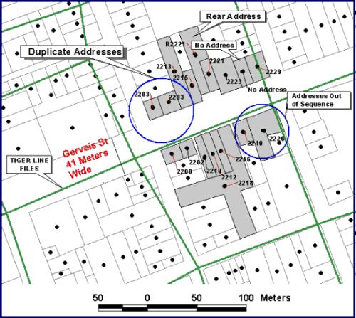
8 Address Matching and Geocoding Frames of Reference Continuous Discrete, Objects, and Areas Street Address: Section, ¼ section, township Larger? City, province, etc Uh-oh, problems Palmetto Seafood Co Gervais St. Columbia, SC USA For the most part databases produce successful geocoding results 8
9 9
10 10

11 11 S4, Brown University
12 Georeferencing a Paper Map Sometimes the data we want is only available in a hard copy Or is an image If we know some important things about the contents of the image or map we can coordinate it with global reference systems Establish links between the image and a geographically known database 12

13 13 S4, Brown University
14 Control Points Link points are called control points Control points should be: Easy to confirm (same location in the world) Be spread across the space being georeferenced Have good overlap between the two datasets Established by clicking as close as possible to your intended target is important (zooming in helps) 14
15 Frames of Reference Global Frames of reference are applied to a model of the Earth (size and shape) Earth s actual shape is too complicated Spheroidal and Ellipsoidal models are used Any single model of the Earth s size and shape is called a geodetic datum 15
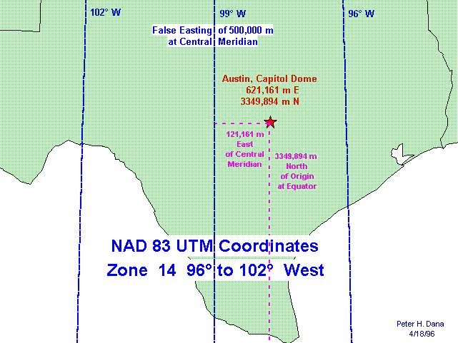
16 Universal Transverse Mercator Locations indicated in meters (from a pair of origins) Lat/Long locations in degrees make it difficult to derive distances between places or make measurements in nonspherical coordinates Most of us intuitively understand meters, kilometers, etc. for distance and area better than degrees, minutes, and seconds 16
17 UTM However This apparent simplicity comes at the cost of a complex frame of reference and multiple origins 17 S4, Brown University

18 18 S4, Brown University
19 19

20 Geodetic Datums 20
Navigation coordinate systems
 Lecture 3 Navigation coordinate systems Topic items: 1. Basic Coordinate Systems. 2. Plane Cartesian Coordinate Systems. 3. Polar Coordinate Systems. 4. Earth-Based Locational Reference Systems. 5. Reference
Purpose : Understanding Projections, 12D, and the System 1200.
 Purpose : Understanding Projections, 12D, and the System 1200. 1. For any Cad work created inside 12D, the distances entered are plane (Horizontal Chord) distances. 2. Setting a projection, or changing
Objectives Learn how to work with projections in GMS, and how to combine data from different coordinate systems into the same GMS project.
 v. 10.2 GMS 10.2 Tutorial Working with map projections in GMS Objectives Learn how to work with projections in GMS, and how to combine data from different coordinate systems into the same GMS project.
Editing with ArcGIS. Contents
 Editing with ArcGIS This tutorial is designed to introduce you to the basic editing tools used in ArcMap for the both the creation and modification of geospatial data. Editing is an essential skill for
LECTURE TWO Representations, Projections and Coordinates
 LECTURE TWO Representations, Projections and Coordinates GEOGRAPHIC COORDINATE SYSTEMS Why project? What is the difference between a Geographic and Projected coordinate system? PROJECTED COORDINATE SYSTEMS
THE FUTURE OF STATE PLANE COORDINATES AT ODOT
 THE FUTURE OF STATE PLANE COORDINATES AT ODOT BY: RAY FOOS P.S. AND BRIAN MEADE P.S. THE OHIO DEPARTMENT OF TRANSPORTATION WORKING WITH STATE PLANE COORDINATES OR HOW TO MAKE THE EARTH FLAT SURVEYORS AND
Objectives Learn how to work with projections in SMS, and how to combine data from different coordinate systems into the same SMS project.
 v. 12.2 SMS 12.2 Tutorial Working with map projections in SMS Objectives Learn how to work with projections in SMS, and how to combine data from different coordinate systems into the same SMS project.
Objectives Learn how to work with projections in SMS, and how to combine data from different coordinate systems into the same SMS project.
 v. 12.3 SMS 12.3 Tutorial Working with map projections in SMS Objectives Learn how to work with projections in SMS, and how to combine data from different coordinate systems into the same SMS project.
Well Unknown ID AKA EPSG: 3857
 Well Unknown ID AKA EPSG: 3857 Pamela Kanu November 2016 WGS 1984 WEB MERCATOR ALIASES: AUXILIARY SPHERE, WKID: 3857, WKID: 102100, WKID: 102113, SHERICAL MERCATOR, WGS 84/PSEUDO-MERCATOR, OPEN LAYERS:
Understanding and Using Geometry, Projections, and Spatial Reference Systems in ArcGIS. Rob Juergens, Melita Kennedy, Annette Locke
 Understanding and Using Geometry, Projections, and Spatial Reference Systems in ArcGIS Rob Juergens, Melita Kennedy, Annette Locke Introduction We want to give you a basic understanding of geometry and
Reduction of Field Observations
 Reduction of Field Observations GNSS/GPS measurements or Latitudes, Longitudes, HAE: We re interested in projected coordinates, e.g., State Plane Survey measurements in a projected coordinate system, on
Geometric Correction of Imagery
 Geometric Correction of Imagery Geometric Correction of Imagery Present by: Dr.Weerakaset Suanpaga D.Eng(RS&GIS) The intent is to compensate for the distortions introduced by a variety of factors, so that
LOCAL GEODETIC HORIZON COORDINATES
 LOCAL GEODETIC HOIZON COODINATES In many surveying applications it is necessary to convert geocentric Cartesian coordinates X,,Z to local geodetic horizon Cartesian coordinates E,N,U (East,North,Up). Figure
State Plane Coordinates and Computations using them GISC Spring 2013
 State Plane Coordinates and Computations using them GISC-3325 - Spring 2013 Map Projections From UNAVCO site hosting.soonet.ca/eliris/gpsgis/lec2geodesy.html Taken from Ghilani, SPC State Plane Coordinate
Technical Specifications
 1 Contents INTRODUCTION...3 ABOUT THIS LAB...3 IMPORTANCE OF THIS MODULE...3 EXPORTING AND IMPORTING DATA...4 VIEWING PROJECTION INFORMATION...5...6 Assigning Projection...6 Reprojecting Data...7 CLIPPING/SUBSETTING...7
SPECIFICATIONS FOR G.I.S. DATA/INFORMATION PROVIDED TO ONE-CALL
 SPECIFICATIONS FOR G.I.S. DATA/INFORMATION PROVIDED TO ONE-CALL Digital Mapping Files that we can accept: 1. G.I.S. dataset formats that we can accept: AutoCad File Latest Releases (*.DWG, *.DXF) ESRI
SPECS FOR G.I.S. DATA PROVIDED TO ONE-CALL
 SPECS FOR G.I.S. DATA PROVIDED TO ONE-CALL DIGITAL MAPPING FILES (very efficient/extremely accurate): 1. G.I.S. dataset formats that we can accept: FORMAT FILE EXT(S) FORMAT FILE EXT(S) AutoCAD (*.dwg,
Real Geodetic Map (Map without Projection) Abstract Keywords: 1. Introduction
 Abstract Keywords: 1. Introduction") Real ( without Projection) Ahmad Shaker 1 Abdullah Saad 1 Abdurrahman Arafa 2* 1.Surveying Dep., Shoubra Faculty of Engineering, Benha University, Egypt 2.Manager of Surveying Dep. in Horse Company. Egypt
Real ( without Projection) Ahmad Shaker 1 Abdullah Saad 1 Abdurrahman Arafa 2* 1.Surveying Dep., Shoubra Faculty of Engineering, Benha University, Egypt 2.Manager of Surveying Dep. in Horse Company. Egypt
SPECIFICATIONS FOR G.I.S. DATA/INFORMATION PROVIDED TO ONE-CALL
 SPECIFICATIONS FOR G.I.S. DATA/INFORMATION PROVIDED TO ONE-CALL Digital Mapping Files that we can accept: 1. G.I.S. dataset formats that we can accept: FORMAT AutoCad File Latest Releases ESRI Arc/Info
SPECS FOR G.I.S. DATA PROVIDED TO ONE-CALL
 SPECS FOR G.I.S. DATA PROVIDED TO ONE-CALL DIGITAL MAPPING FILES (very efficient/extremely accurate): 1. G.I.S. dataset formats that we can accept: FORMAT FILE EXT(S) FORMAT FILE EXT(S) AutoCAD (*.dwg,
SPECS FOR G.I.S. DATA PROVIDED TO ONE-CALL
 SPECS FOR G.I.S. DATA PROVIDED TO ONE-CALL DIGITAL MAPPING FILES (very efficient/extremely accurate): 1. G.I.S. dataset formats that we can accept: FORMAT FILE EXT(S) FORMAT FILE EXT(S) AutoCAD (*.dwg,
GRASS GIS - Introduction
 GRASS GIS - Introduction What is a GIS A system for managing geographic data. Information about the shapes of objects. Information about attributes of those objects. Spatial variation of measurements across
PhotoGeoDWG. Users Guide and Administration Notes, Version 1.0.0
 PhotoGeoDWG Users Guide and Administration Notes, 2012 - Version 1.0.0 About this Document: The content of this document is an updated version of the documentation delivered with the plug-in. This document
Obtaining Aerial Images from Google Earth
 Obtaining Aerial Images from Google Earth Introduction This tutorial will demonstrate how to use the Google Earth application to obtain a site-wide aerial photograph for a modeling project. The tutorial
Geoapplications development Control work 1 (2017, Fall)
") Page 1 Geoapplications development Control work 1 (2017, Fall) Author: Antonio Rodriges, Oct. 2017 http://rgeo.wikience.org/ Surname, name, patronymic: Group: Date: Signature: Select all correct statements.
Page 1 Geoapplications development Control work 1 (2017, Fall) Author: Antonio Rodriges, Oct. 2017 http://rgeo.wikience.org/ Surname, name, patronymic: Group: Date: Signature: Select all correct statements.
UTM Geo Map APP Quick Start (Version 1.2)
") UTM Geo Map APP Quick Start (Version 1.2) Measure Points (Marker) You can measure points of coordinate base on GPS or position on the Maps and save marker into database for unlimited number using Real-time
UTM Geo Map APP Quick Start (Version 1.2) Measure Points (Marker) You can measure points of coordinate base on GPS or position on the Maps and save marker into database for unlimited number using Real-time
OziExplorer Training and Help Manual for Use with Soil Resource Stewardship Monitoring Checklist: Cutblock-Level
 for Use with Soil Resource Stewardship Monitoring Checklist: Cutblock-Level Stéphane Dubé, Soil Scientist MOFR Northern Interior Forest Region May 2009 Version 2 Starting up This section will describe
HP-33S Calculator Program TM 1
 Programmer: Dr. Bill Hazelton Date: March, 2005. Line Instruction Line Instruction Line Instruction T0001 LBL T U0022 STOP U0061 x < > y T0002 CL Σ U0023 RCL U U0062 x < 0? T0003 INPUT K U0024 RCL E U0063
COORDINATE TRANSFORMATION. Lecture 6
 COORDINATE TRANSFORMATION Lecture 6 SGU 1053 SURVEY COMPUTATION 1 Introduction Geomatic professional are mostly confronted in their work with transformations from one two/three-dimensional coordinate system
Fundamentals of Structural Geology Exercise: concepts from chapter 2
 0B Reading: Fundamentals of Structural Geology, Ch 2 1) Develop a MATLAB script that plots the spherical datum (Fig. 2.1a) with unit radius as a wire-frame diagram using lines of constant latitude and
Coordinate Transformation for Macau Data Using ArcGIS for Desktop
 Coordinate Transformation for Macau Data Using ArcGIS for Desktop Article ID : TT100062 Software : ArcGIS 10.2 for Desktop Platform : Windows 7, Windows 8, Windows Server 2003, Windows Server 2008/R2 Date
APPENDIX 13 TERRAIN NAVIGATOR PRO BASICS. Prepared by the Mapping and Marking Committee. Fifth Edition (Revised and Expanded) June 2014
 June 2014") APPENDIX 13 TERRAIN NAVIGATOR PRO BASICS Prepared by the Mapping and Marking Committee Fifth Edition (Revised and Expanded) June 2014 Published by the Oregon-California Trails Association P.O. Box 1019
APPENDIX 13 TERRAIN NAVIGATOR PRO BASICS Prepared by the Mapping and Marking Committee Fifth Edition (Revised and Expanded) June 2014 Published by the Oregon-California Trails Association P.O. Box 1019
Exercise One: Estimating The Home Range Of An Individual Animal Using A Minimum Convex Polygon (MCP)
") --- Chapter Three --- Exercise One: Estimating The Home Range Of An Individual Animal Using A Minimum Convex Polygon (MCP) In many populations, different individuals will use different parts of its range.
--- Chapter Three --- Exercise One: Estimating The Home Range Of An Individual Animal Using A Minimum Convex Polygon (MCP) In many populations, different individuals will use different parts of its range.
Creating Mercator s Map Projection
 Creating Mercator s Map Projection Andrew Geldean December 17, 2014 Abstract: This map developed by Gerardus Mercator in 1569 is created by producing a cylinder around the globe projecting the surface
Geographic Information Systems. using QGIS
 Geographic Information Systems using QGIS 1 - INTRODUCTION Generalities A GIS (Geographic Information System) consists of: -Computer hardware -Computer software - Digital Data Generalities GIS softwares
Main concepts of ILWIS 3.0
 CHAPTER 2 Main concepts of ILWIS 3.0 In chapter one, Introduction to ILWIS, you started with ILWIS, and learned the basics of the user interface. This chapter presents some key concepts of ILWIS. In section
Google Earth an introduction
 Luana Valentini InternetGIS course - 2011 Google Earth an introduction Google Earth combines the power of Google Search with satellite imagery, maps, terrain and 3D buildings to put the world's geographic
Objectives Learn how to work with projections in WMS, and how to combine data from different coordinate systems into the same WMS project.
 s v. 11.0 Projections / Coordinate Systems WMS 11.0 Tutorial Projections / Coordinate Systems Working with map projections in WMS Objectives Learn how to work with projections in WMS, and how to combine
SurvCE: Localizations
 SurvCE: Localizations Mark Silver Electrical Engineer, not a Surveyor Carlson Dealer in Salt Lake City Utah Embarrassing Fact: I have a 250,000+ sheet paper map collection. igage Mapping Corporation www.igage.com
National Register of Historic Places: GIS Webinar Cultural Resource GIS Facility National Park Service June 2012
 National Register of Historic Places: GIS Webinar Cultural Resource GIS Facility National Park Service June 2012 National Register Draft Electronic Map Policy Factsheet Required: WGS/NAD datum A map that
Geometric Rectification of Remote Sensing Images
 Geometric Rectification of Remote Sensing Images Airborne TerrestriaL Applications Sensor (ATLAS) Nine flight paths were recorded over the city of Providence. 1 True color ATLAS image (bands 4, 2, 1 in
Exercise One: Creating A Map Of Species Distribution For A Publication
 --- Chapter three --- Exercise One: Creating A Map Of Species Distribution For A Publication One of the first, and most common, tasks you will want to do in using GIS is to produce maps for use in presentations,
Objectives Learn how to work with projections in GMS, and how to combine data from different coordinate systems into the same GMS project.
 v. 10.4 GMS 10.4 Tutorial Working with map projections in GMS Objectives Learn how to work with projections in GMS, and how to combine data from different coordinate systems into the same GMS project.
TLS Parameters, Workflows and Field Methods
 TLS Parameters, Workflows and Field Methods Marianne Okal, UNAVCO June 20 th, 2014 How a Lidar instrument works (Recap) Transmits laser signals and measures the reflected light to create 3D point clouds.
The Data Journalist Chapter 7 tutorial Geocoding in ArcGIS Desktop
 The Data Journalist Chapter 7 tutorial Geocoding in ArcGIS Desktop Summary: In many cases, online geocoding services are all you will need to convert addresses and other location data into geographic data.
An Introduction to Geographic Information Systems (GIS) using ArcGIS 9.2
 using ArcGIS 9.2") An Introduction to Geographic Information Systems (GIS) using ArcGIS 9.2 by Marcel Fortin, GIS and Map Librarian, University of Toronto Libraries, 2009 gis.maps@utoronto.ca http://www.library.utoronto.ca/maplib/
An Introduction to Geographic Information Systems (GIS) using ArcGIS 9.2 by Marcel Fortin, GIS and Map Librarian, University of Toronto Libraries, 2009 gis.maps@utoronto.ca http://www.library.utoronto.ca/maplib/
Geological mapping using open
 Geological mapping using open source QGIS MOHSEN ALSHAGHDARI -2017- Abstract Geological mapping is very important to display your field work in a map for geologist and others, many geologists face problems
Yandex.Maps API Background theory
 8.02.2018 .. Version 1.0 Document build date: 8.02.2018. This volume is a part of Yandex technical documentation. Yandex helpdesk site: http://help.yandex.ru 2008 2018 Yandex LLC. All rights reserved.
ISO/FDIS INTERNATIONAL STANDARD FINAL DRAFT. Geographic information Spatial referencing by coordinates ISO/TC 211.
 FINAL DRAFT INTERNATIONAL STANDARD ISO/FDIS 19111 ISO/TC 211 Secretariat: NSF Voting begins on: 2002-11-07 Voting terminates on: 2003-01-07 Geographic information Spatial referencing by coordinates Information
Smart GIS Course. Developed By. Mohamed Elsayed Elshayal. Elshayal Smart GIS Map Editor and Surface Analysis. First Arabian GIS Software
 Smart GIS Course Developed By Mohamed Elsayed Elshayal Elshayal Smart GIS Map Editor and Surface Analysis First Arabian GIS Software http://www.freesmartgis.blogspot.com/ http://tech.groups.yahoo.com/group/elshayalsmartgis/
ISO/FDIS INTERNATIONAL STANDARD FINAL DRAFT. Geographic information Spatial referencing by coordinates ISO/TC 211.
 FINAL DRAFT ISO/TC 211 Secretariat: NSF Voting begins on: 2002-11-07 Voting terminates on: 2003-01-07 RECIPIENTS OF THIS DRAFT ARE INVITED TO SUBMIT, WITH THEIR COMMENTS, NOTIFICATION OF ANY RELEVANT PATENT
Basic Tasks in ArcGIS 10.3.x
 Basic Tasks in ArcGIS 10.3.x This guide provides instructions for performing a few basic tasks in ArcGIS 10.3.1, such as adding data to a map document, viewing and changing coordinate system information,
Georeferencing Maps With Contours
 Georeferencing Maps With Contours Peter BAJCSY National Center for Supercomputing Applications 605 East Springfield Avenue, Champaign, IL 61820 and Tyler J. ALUMBAUGH National Center for Supercomputing
ArcMap and Google Earth
 ArcMap and Google Earth Prepared by Andrew Hobby CVEN 658 November 25, 2008 Contents: Brief Overview of Google Earth Goals of Exercise Computer and Data Requirements Procedure: 1. Creating a KML File 2.
RECOMMENDATION ITU-R P DIGITAL TOPOGRAPHIC DATABASES FOR PROPAGATION STUDIES. (Question ITU-R 202/3)
") Rec. ITU-R P.1058-1 1 RECOMMENDATION ITU-R P.1058-1 DIGITAL TOPOGRAPHIC DATABASES FOR PROPAGATION STUDIES (Question ITU-R 202/3) Rec. ITU-R P.1058-1 (1994-1997) The ITU Radiocommunication Assembly, considering
Rec. ITU-R P.1058-1 1 RECOMMENDATION ITU-R P.1058-1 DIGITAL TOPOGRAPHIC DATABASES FOR PROPAGATION STUDIES (Question ITU-R 202/3) Rec. ITU-R P.1058-1 (1994-1997) The ITU Radiocommunication Assembly, considering
Prosurv LLC Presents
 Prosurv LLC Presents An Enterprise-Level Geo-Spatial Data Visualizer Signing-In If you re an Admin user, such as an Executive, Manager, or Human Resources (HR) member, you will see the following screen
Ilham Marsudi Universitas Negeri Yogyakarta Yogyakarta, Indonesia
 1st International Conference on Technology and Vocational Teachers (ICTVT 2017) Making a Digital Contour Map Ilham Marsudi Universitas Negeri Yogyakarta Yogyakarta, Indonesia ilham@uny.ac.id Abstract---
High-Precision Positioning Unit 2.2 Student Exercise: Calculating Topographic Change
 High-Precision Positioning Unit 2.2 Student Exercise: Calculating Topographic Change Ian Lauer and Ben Crosby (Idaho State University) Change is an inevitable part of our natural world and varies as a
WHERE THEORY MEETS PRACTICE
 world from others, leica geosystems WHERE THEORY MEETS PRACTICE A NEW BULLETIN COLUMN BY CHARLES GHILANI ON PRACTICAL ASPECTS OF SURVEYING WITH A THEORETICAL SLANT february 2012 ² ACSM BULLETIN ² 27 USGS
Exploring GIS Data. I) GIS Data Models-Definitions II) Database Management System III) Data Source & Collection IV) Data Quality
 GIS Data Models-Definitions II) Database Management System III) Data Source & Collection IV) Data Quality") Exploring GIS Data I) GIS Data Models-Definitions II) Database Management System III) Data Source & Collection IV) Data Quality 1 Geographic data Model Definitions: Data : A collection of related facts
Exploring GIS Data I) GIS Data Models-Definitions II) Database Management System III) Data Source & Collection IV) Data Quality 1 Geographic data Model Definitions: Data : A collection of related facts
In order to follow this set of directions you will need the following
 How to Create Maps & Figures in ArcView 9x In order to follow this set of directions you will need the following 1) the Jenny s Louisiana GIS Instructional CD 2) a computer with ArcGIS on it (version 9.0
GPS/GIS Activities Summary
 GPS/GIS Activities Summary Group activities Outdoor activities Use of GPS receivers Use of computers Calculations Relevant to robotics Relevant to agriculture 1. Information technologies in agriculture
Novel Real-Time Coordinate Transformations based on N-Dimensional Geo-Registration Parameters' Matrices
 FIG Working Week 009, Eilat, Israel, -8 May 009 Novel Real-Time Coordinate Transformations based on N-Dimensional Geo-Registration Parameters' Matrices Sagi Dalyot, Ariel Gershkovich, Yerach Doythser Mapping
Mapping and Modeling Lidar Data with ArcGIS Pro
 Mapping and Modeling Lidar Data with ArcGIS Pro By Mike Price, Entrada/San Juan, Inc. What you will need An ArcGIS Pro license ArcGIS Spatial Analyst or ArcGIS 3D Analyst extension license Sample dataset
DATA MANAGEMENT MODEL
 DATA MANAGEMENT MODEL InfoCoSM Arto Vuorela Vesa Roivas Jean-Pierre Houix 26-29.6.2006 INTRODUCTION This report is an intermediary report summarizing the main objectives to be reached by the end of July
Base Configurations Carlson SurvCE
 There are six methods to set the stationary base position, organized into 2 categories: From New Position includes Read from GPS, Enter Lat/Long and Enter Grid System Coordinates. The From Known Position
How to Relay Information About Where You Are
 How to Relay Information About Where You Are 2017 12 18 Gary Ataman Five Winds Backcountry Ski Club President Where Are You? When you are in the backcountry keep track of where you are. When incidents
NAACCR Geocoding Tutorial
 NAACCR Geocoding Tutorial Introduction The goal of the tutorial is to familiarize you with the NAACCR online geocoder. The NAACCR geocoder can be used to geocode one address at a time or in batch mode
3. Map Overlay and Digitizing
 3. Map Overlay and Digitizing 3.1 Opening Map Files NavviewW/SprayView supports digital map files in ShapeFile format from ArcView, DXF format from AutoCAD, MRK format from AG-NAV, Bitmap and JPEG formats
Analysing crime data in Maps for Office and ArcGIS Online
 Analysing crime data in Maps for Office and ArcGIS Online For non-commercial use only by schools and universities Esri UK GIS for School Programme www.esriuk.com/schools Introduction ArcGIS Online is a
Review of Cartographic Data Types and Data Models
 Review of Cartographic Data Types and Data Models GIS Data Models Raster Versus Vector in GIS Analysis Fundamental element used to represent spatial features: Raster: pixel or grid cell. Vector: x,y coordinate
GEOREFERENCING FOR DUMMIES An Elaboration of the MaNIS/HerpNET/ORNIS Guidelines
 GEOREFERENCING FOR DUMMIES An Elaboration of the MaNIS/HerpNET/ORNIS Guidelines Note: The most important thing to remember is that all assumptions made in determining coordinates, extent, and error need
GEON LiDAR Workflow (GLW) Users Guide
 Users Guide") GEON LiDAR Workflow (GLW) Users Guide Joshua Coyan Christopher Crosby Ramón Arrowsmith School of Earth and Space Exploration Arizona State University 24 October 2007 http://lidar.asu.edu Table of Contents
GEON LiDAR Workflow (GLW) Users Guide Joshua Coyan Christopher Crosby Ramón Arrowsmith School of Earth and Space Exploration Arizona State University 24 October 2007 http://lidar.asu.edu Table of Contents
ADAMS FUNCTIONAL DESCRIPTION FOR THE CORONA 350 II FLIR SYSTEMS POLYTECH AB
 ADAMS FUNCTIONAL DESCRIPTION FOR THE CORONA 350 II FLIR SYSTEMS POLYTECH AB Table of Contents Table of Contents... 1 Introduction... 2 Overview... 2 Purpose... 2 ADAMS Functional Description... 3 Setup
WILD 2400 ASSIGNMENT #1: GPS TUTORIAL*
 WILD 2400 ASSIGNMENT #1: GPS TUTORIAL* Overview: In this tutorial you will learn how to collect, download, and display data using a Garmin GPSMAP 64 unit, the DNRGPS Application, and Google Earth. For
Understanding and Using Geometry, Projections, and Spatial Reference Systems in ArcGIS Annette Locke, Rob Juergens
 Understanding and Using Geometry, Projections, and Spatial Reference Systems in ArcGIS Annette Locke, Rob Juergens Introduction We present fundamental concepts necessary for the correct and efficient use
Chapter 9. Attribute joins
 Chapter 9 Spatial Joins 9-1 Copyright McGraw-Hill Education. Permission required for reproduction or display. Attribute joins Recall that Attribute joins: involve combining two attribute tables together
Lecture 7 Digitizing. Dr. Zhang Spring, 2017
 Lecture 7 Digitizing Dr. Zhang Spring, 2017 Model of the course Using and making maps Navigating GIS maps Map design Working with spatial data Geoprocessing Spatial data infrastructure Digitizing File
Google Map & Radius Search Realtyna Inc.
 1 Google Map & Radius Search Realtyna Inc. Contents of this manual are applicable to the RPL Google Map& Radius Search Add-on version 3.4+. If you have an older version of the membership add-on, sections
Reference Systems for Surveying and Mapping CTB3310 Surveying and Mapping
 Delft University of Technology Reference Systems for Surveying and Mapping CTB3310 Surveying and Mapping Hans van der Marel ii The front cover shows the NAP (Amsterdam Ordnance Datum) datum point at the
OziExplorer Training and Help Manual for Use with Soil Resource Stewardship Monitoring Checklist: Cutblock-Level
 OziExplorer Training and Help Manual for Use with Soil Resource Stewardship Monitoring Checklist: Cutblock-Level Stéphane Dubé, Soil Scientist MOFR Northern Interior Forest Region May 2009 Version 2 Starting
Introduction to Distance Sampling. Automated Survey Design Exercises
 Introduction to Distance Sampling Automated Survey Design Exercises 1. Point transect survey of North-eastern Mexico Reviewing the data Extract and open the project MexicoUnPrj from the archive MexicoUnPrj.zip.
Updating Autonomous Start to an RTK Field Survey (Part II)
") Updating Autonomous Start to an RTK Field Survey (Part II) Oscar R. Cantu Topcon University FTP Site For access to previously offered webinars and supporting documentation, please go to: ftp://tulive+topconuniversity.com:tulive@ftp.topconuniversity.com
Updating Autonomous Start to an RTK Field Survey (Part II) Oscar R. Cantu Topcon University FTP Site For access to previously offered webinars and supporting documentation, please go to: ftp://tulive+topconuniversity.com:tulive@ftp.topconuniversity.com
Correcting INS Drift in Terrain Surface Measurements. Heather Chemistruck Ph.D. Student Mechanical Engineering Vehicle Terrain Performance Lab
 Correcting INS Drift in Terrain Surface Measurements Ph.D. Student Mechanical Engineering Vehicle Terrain Performance Lab October 25, 2010 Outline Laboratory Overview Vehicle Terrain Measurement System
Successfully Filing Broadband Deployment Data with USAC
 Successfully Filing Broadband Deployment Data with USAC Meet our Team Alex Wolff Manager of Project and Product Management alex.wolff@usac.org Bill Johnson Director of Geographic Information Systems (GIS)
Hamilton County Draw Widget Measurements Page 2 of 11
 Hamilton County Draw Widget Measurements Larry Stout June 11, 2013 Introduction The Hamilton County Draw Widget is based on the Draw Widget from Version 2 of the Esri Flex Viewer. We have made several
GIS IN ECOLOGY: CREATING RESEARCH MAPS
 GIS IN ECOLOGY: CREATING RESEARCH MAPS Contents Introduction... 2 Elements of Cartography... 2 Course Data Sources... 3 Tasks... 3 Establishing the Map Document... 3 Laying Out the Map... 5 Exporting Your
Lucas County Engineer s GIS Maps User Guide
 Lucas County Engineer s GIS Maps User Guide The Web Map Interface On the left hand side of the screen, you will see the Legend of the layers shown in the map. If you click on Details, you will see just
From Non-Spatial Data to Spatial Data. Geocoding & Georeferencing in ArcGIS
 03-Geocoding & Georeferencing In Arcgis.Doc Page 1 of 10 From Non-Spatial Data to Spatial Data. Geocoding & Georeferencing in ArcGIS Objectives Upon completion of this tutorial, you should be able to perform
Behavioral Modes Segmentation: GIS Visualization Movement Ecology CEAB 15 June, 2012
 Behavioral Modes Segmentation: GIS Visualization Movement Ecology Lab @ CEAB 15 June, 2012 GIS visualization for segmentation and annotation of animal movement trajectories (for single or few trajectories
Map Tools: A Transformative Experience
 Bonus Chapter 3 Map Tools: A Transformative Experience The Autodesk AutoCAD Civil 3D 2016 software contains most of the functionality that can be found in the Autodesk AutoCAD Map 3D 2016 software. As
How To: Geocode. Quest Analytics Suite Geocoding. Geocoding in the Quest Analytics Suite 1. When the software is open, select the Tools dropdown.
 How To: Geocode in the Quest Analytics Suite 1. When the software is open, select the Tools dropdown. 2. Click the option for Geocode a Table 3. On the left-hand side of the pop up box there are 5 circles
GOVERNMENT GAZETTE REPUBLIC OF NAMIBIA
 GOVERNMENT GAZETTE OF THE REPUBLIC OF NAMIBIA N$7.20 WINDHOEK - 7 October 2016 No. 6145 CONTENTS Page GENERAL NOTICE No. 406 Namibia Statistics Agency: Data quality standard for the purchase, capture,
INTRODUCTION TO GIS WORKSHOP EXERCISE
 111 Mulford Hall, College of Natural Resources, UC Berkeley (510) 643-4539 INTRODUCTION TO GIS WORKSHOP EXERCISE This exercise is a survey of some GIS and spatial analysis tools for ecological and natural
On Grid: Tools and Techniques to Place Reality Data in a Geographic Coordinate System
 RC21940 On Grid: Tools and Techniques to Place Reality Data in a Geographic Coordinate System Seth Koterba Principal Engineer ReCap Autodesk Ramesh Sridharan Principal Research Engineer Infraworks Autodesk
Open Source Cloud Map User Guide
 Open Source Cloud Map User Guide Table of Contents Map Page... 1 Static Mercator Map... 1 Customizable Map... 1 Title Bar... 2 Toolbar... 2 Non Toolbar Navigation... 3 Map Window... 3 Layers / Legend Window...
Georeferencing. Georeferencing: = linking a layer or dataset with spatial coordinates. Registration: = lining up layers with each other
 Georeferencing How do we make sure all our data layers line up? Georeferencing: = linking a layer or dataset with spatial coordinates Registration: = lining up layers with each other Rectification: The
Georeferencing Protocol KUMIP
 Georeferencing Protocol KUMIP Setting up in Specify 1) Go to Edit>Preferences in the Specify menu at the top and make sure that your GEOLocate preferences are correct. They should look like this: 2) Import
Buckskin Detachment Surface Interpolation, Southern Lincoln Ranch Basin, Buckskin Mountains, Western Arizona Hal Hundley
 Buckskin Detachment Surface Interpolation, Southern Lincoln Ranch Basin, Buckskin Mountains, Western Arizona Hal Hundley Introduction The Lincoln Ranch basin in Buckskin Mountains in west-central Arizona
Exercise 6-1 Image Georegistration Using RESAMPLE
 Exercise 6-1 Image Georegistration Using RESAMPLE Resampling is a procedure for spatially georeferencing an image to its known position on the ground. Often, this procedure is used to register an image