Hyperspectral Image Acquisition and Analysis
|
|
|
- Chrystal Brooks
- 6 years ago
- Views:
Transcription

1 Hyperspectral Image Acquisition and Analysis PECORA 15 Workshop 7 Airborne Remote Sensing: A Fast-track Approach to NEPA Streamlining for Transportation Jen Aitken, ITRES Research Limited

2 CASI Hyperspectral and Lidar DEM
3 Presentation Outline Project description Why hyperspectral? Casi image acquisition Creation of image map Analysis of hyperspectral imagery to produce wetland classification - validation & verification Conclusions
4 Project Objectives Need to know location and extent of wetlands within a future transportation corridor Acquire high spatial and spectral resolution imagery for semi rural area south east of High Point, NC Produce thematic vegetation map highlighting potential wetlands Combine imagery with topography from lidar
 Sensor / data fusion radiometric, atmospheric, mosaic Spectral Classifications AeroScan LIDAR (lidar) DEM (bare earth/canopy) PRODUCTS Wetlands & land cover")
5 Project design Airborne Data Collection Data Processing / Data Fusion Analysis / Feature Extraction Validation & Verification Ground-truth (spectral, biology) CASI & GPS/IMU (hyperspectral) Sensor / data fusion radiometric, atmospheric, mosaic Spectral Classifications AeroScan LIDAR (lidar) DEM (bare earth/canopy) PRODUCTS Wetlands & land cover classifications
6 Why hyperspectral? Many narrow spectral bands offers the ability to separate community level (and species) land cover features. Hyperspectral provides subtle spectral signatures or curves of terrestrial targets. Using hyperspectral makes it easier to unmix pixels, thus improving confidence in classification results.
7 Spectral Radiance Why hyperspectral? Multispectral Simulation (Scene Brightness) 4 spectral bands (blue, green, red, IR) dark deciduous bright deciduous kudzu field 1 exposed soil road field Wavelength (nm) The use of only a few spectral bands reduces discrimination capabilities and can create more confusion/uncertainty in the final classification
8 Spectral Radiance Why hyperspectral? CASI Spectral Radiance Curves deciduous vs kudzu dark deciduous bright deciduous kudzu field 1 exposed soil road field Wavelength (nm) The use of many spectral bands allows for detailed discrimination of features
9 48 Spectral bands: Iowa 2002 The use of many spectral bands allows for detailed discrimination of features

10 Hyperspectral vs. Satellite The use of many spectral bands allows for detailed discrimination of features

11 Why hyperspectral? CASI False color IR True color Simulated CIR

12 To High Point Project Area

13 CASI mosaics of DOT project area Spatial res: 1m # Spectral bands: 14 Red = 740 nm Green = 710 nm Blue = 550 nm
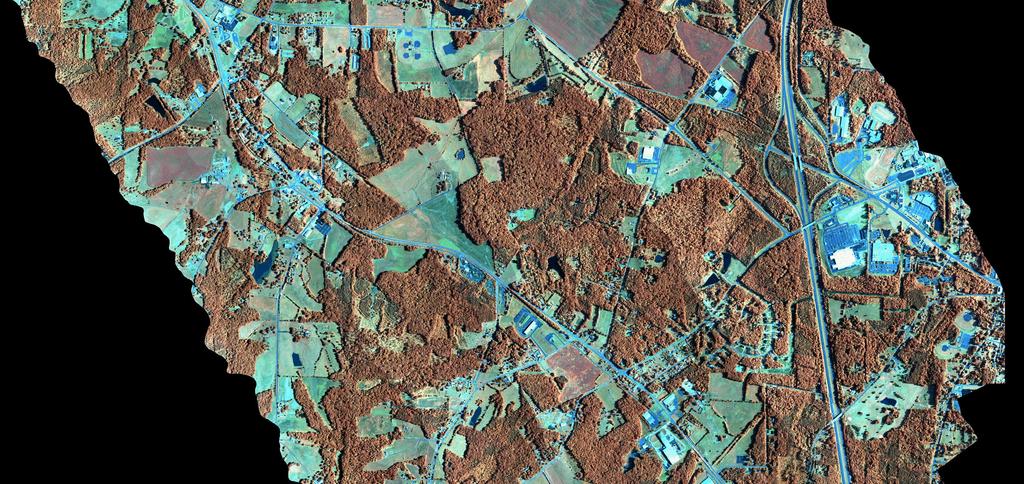
14 Mosaic 4
15

16 CASI 60cm Subarea Eleven spectral bands. 9 square kilometers.
17 CASI Data Acquisition Project area approximately 5 km x 18 km. Thirteen flight lines flown at one meter resolution (headings 330 and 150, altitude 3150 ft. ASL). Fourteen spectral bands from 430 nm to 878 nm. Bandwidth: 15 nm (blue band 40 nm). Subarea imaged at 60 cm, 11 bands. Three hours to acquire data.
18 CASI Standard Processing Image data radiometrically corrected to standard radiance units (SRU s). Imagery combined with GPS / IMU data and geometrically corrected into five mosaics covering project area. Removal of atmosphere from image data, production of reflectance measurements. Radiometric Corrections Atmospheric Corrections Geometric Corrections

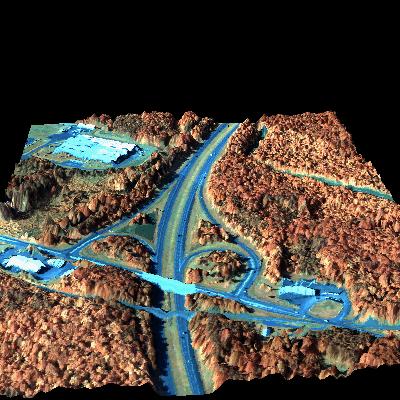
19 Casi fused with Lidar
20 Spatial Accuracy Assessment An independent spatial accuracy assessment was performed comparing image coordinates with 31 surveyed ground control points. TEST 1 X-coordinate (m) Y-coordinate (m) Mean Std Dev RMSE TEST 2 X-coordinate (m) Y-coordinate (m) Mean Std Dev RMSE
21 Keys to Successful Classification Radiometric integrity of the imagery and the quality of the ground truth. Precision geometric corrections to identify ground truth sites in the imagery. Also allows for sensor/data fusion to improve classification results. Hyperspectral bandset. Ground truth surveys by wetland biologist. Calibration, validation & verification Addition of digital elevation data and hydric soils.
22 Ground truth, validation & verification Field visit 1 GPS, vegetation type, drainage, soil type This information used to calibrate the spectral libraries (control) Analysis performed to produce preliminary classifications Field visit 2 validate classification results (test) Finalize spectral library and apply analysis
23 Wetland Criteria In order to be considered a wetland, an area must meet three criteria: Drainage Vegetation Hydric Soils False wetland sites may meet one or two of these criteria, but not all three.

24 Treed Wetland

25 Wetland in a grazed field

26 Roadside Wetland

27 Wetland in pasture

28 Site 15, Wetland in Grazed Pasture

29 Wetland in pasture

30 False wetland
31 Classification Scheme Class Wetland Vegetation Obligate Wetland (OBL) Description Juncus species (rushes), carex species (sedges) and rarely, typha species (cattail), impatiens capensis (forget-me-not), saggitaria latifolia (arrowhead), polygonum spp. (smartweed). Some members of poaceae grass family Under tree cover: microsteris gracilis Willow class Obligate Wetland (OBL) Facultative (FACW) Wetland vegetation types are often mixed with each other and with non-wetland vegetation. Salix nigra (black willow) Rosa palustris (swamp rose) Sambucus Canadensis (elderberry) Faxinus pennsylvanica (green ash) Alnus serrulata (tag alder) Sometimes associated with wetlands, sometimes found in upland Tree and Scrub/ Shrub Facultative (FAC and FACU) Upland (U) Sparse grass (nonwetland) Facultative (FAC) Facultative Upland (FACU) Dense grass (nonwetland) Facultative (FAC) and Facultative Upland (FACU) Bare soil Acer rubrum (red maple) Liquidimbar styraciflura (sweetgum) Liriodendron tulipifera (yellow poplar) Lagustrum sinese (Chinese pivit) Mostly deciduous tree, some conifer stands of varying height. Conifer classification shows spectral confusion with sedges and grasses. Development of a conifer mask should minimize the confusion. Members of Poacae family Lollium multiflorum Often associated with agriculture and urban development in this area. Often associated with agriculture and urban development in this area. Considered to be similar to sparse grass FAC but more dense. Little or no vegetation present.
32 Spectral Library Generation Ground truth sites plotted on casi image mosaics. Noise reduction of imagery in ENVI software (MNF and PPI procedures). Spectrally pure pixels isolated in the imagery which coincide with ground truth sites. Reflectance values for each band are extracted from pure pixels to create spectral signature.
33 Spectral Signatures of Vegetation Chlorophyll absorption Chlorophyll scattering Near infrared reflectance
34 Spectral Signatures of Water Bodies Reflectance determined by water content (sediments, vegetation, organic and inorganic material) Vegetation content Sediment Clear water
35 Wetland Vegetation Classification 32 spectral signatures for vegetation in the spectral library Seven thematic categories based on NWI Classification Scheme: Tree/shrub Bare soil Dense grass and Sparse grass Obligate wetland species Facultative wetland species Willow

36 Ground Truth Sites, June 2000 and March 2001
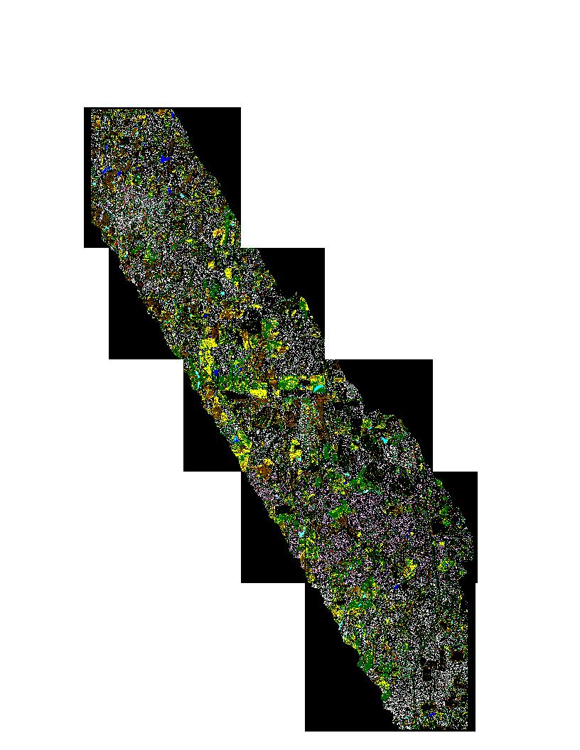
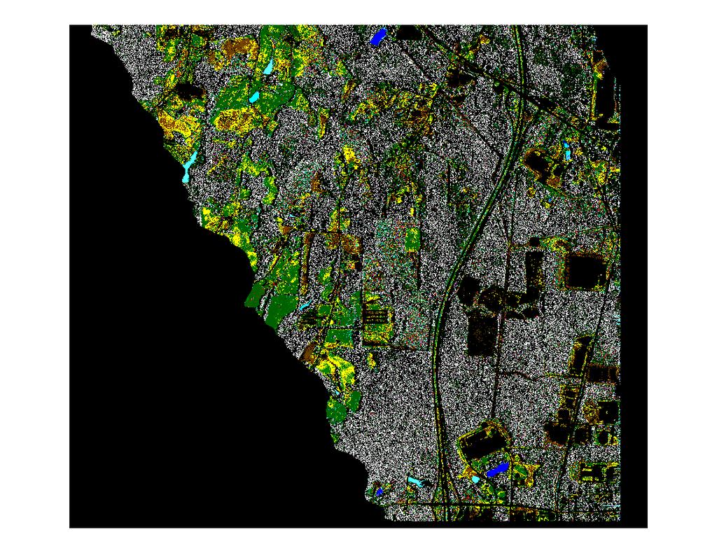
37 Thematic Classification

38 Mosaic 2 Thematic Classification

39 Mosaic 2 Classification: Subarea
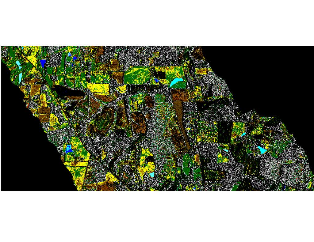
40 Mosaic 3 Classification

41 Mosaic 3 Classification: Subarea

42 Site 10, Natural spring in grazed field

.")
43 Site 10, Two natural springs in grazed field True color with lidar overlay (left) Classified image (right). Red = Obligate wetland

44 Site 7, narrow wetland drainage under mature tree canopy. This type of wetland can not be classified in casi imagery collected in mid summer. However, LIDAR provided information re drainage and depressions.

45 Site 7, Treed Wetland Surveyed wetland under tree canopy Potential associated wetland indicated by drainage and casi classification
46 Classification Accuracy Assessment, Original Ground Truth Sites Twelve sites, ten wetland, two false wetland, four sites with tree cover. Total accuracy of 12 sites: 7 of 12 = 58% Accuracy of wetland sites: 6 of 10 = 60% Accuracy of non treed sites, wetland and non wetland: 7 of 8 = 88%
47 Conclusion of First Accuracy Assessment Small size and heterogeneity of wetlands make classification a challenge. Sites with tree cover are difficult to classify using casi data alone. Lidar can identify drainage contours under tree canopy. Some wetland sites not classifying as wetland, suggesting more spectra should be added to spectral library.
48 Mosaic 5 Classification

49 Mosaic 5 Classification: Subarea


50 Wetland Drainage into Pond Wetland vegetation in project area is typically isolated in small stands in drainage features. On the right, wetland vegetation is classified as red.
51 Classification Accuracy Assessment Number Two Fifteen sites identified from classified imagery and visited March Total sites correctly classified: 10 of 15 = 67% Accuracy of wetland sites: 7 of 7 = 100% Accuracy of non wetland sites: 3 of 8 = 38%
52 Conclusions of Second Classification Accuracy Assessment Some non wetland vegetation is incorrectly classified as wetland. Thematic map is overclassified for wetlands. True wetland areas are classified correctly. Additional data sources (lidar, hydric soils) can eliminate classified areas which do not meet drainage and hydric soils criteria.
53 General Conclusions An area 5 km x 18 km can be imaged in one day at meter and sub meter resolution. Spatial accuracies at the one meter level are measurable. 14 spectral bands can be acquired in the VNIR. Bandwidths are 15 nm (blue band is 40 nm). Precise georeferencing of casi and lidar data make integration seamless. Lidar data used in the casi image geocorrection to provide terrain elevations and used in analysis to indicate drainage and surface depressions.
54 General Conclusions (cont d) Currently only airborne data provides the spatial and spectral resolution required to find small heterogeneous wetlands and altered wetlands. It is possible to classify wetland vegetation using casi hyperspectral imagery, very specific ground truth information and commercial image processing software. Water bodies are easily distinguished and a relative measure of their constituents (sediment, organic content) can be made without ground truth.
55 General Conclusion (cont d) Currently some overclassification of wetland vegetation occurs and difficulties are encountered under tree cover. Classified casi maps made must be refined by integrating additional data from lidar and hydric soils maps. The additional information reduces the false positives found in vegetation maps derived solely from casi imagery.
Airborne Hyperspectral Imaging Using the CASI1500
 Airborne Hyperspectral Imaging Using the CASI1500 AGRISAR/EAGLE 2006, ITRES Research CASI 1500 overview A class leading VNIR sensor with extremely sharp optics. 380 to 1050nm range 288 spectral bands ~1500
Remote Sensing Introduction to the course
 Remote Sensing Introduction to the course Remote Sensing (Prof. L. Biagi) Exploitation of remotely assessed data for information retrieval Data: Digital images of the Earth, obtained by sensors recording
THE EFFECT OF TOPOGRAPHIC FACTOR IN ATMOSPHERIC CORRECTION FOR HYPERSPECTRAL DATA
 THE EFFECT OF TOPOGRAPHIC FACTOR IN ATMOSPHERIC CORRECTION FOR HYPERSPECTRAL DATA Tzu-Min Hong 1, Kun-Jen Wu 2, Chi-Kuei Wang 3* 1 Graduate student, Department of Geomatics, National Cheng-Kung University
LIDAR MAPPING FACT SHEET
 1. LIDAR THEORY What is lidar? Lidar is an acronym for light detection and ranging. In the mapping industry, this term is used to describe an airborne laser profiling system that produces location and
Airborne LiDAR Data Acquisition for Forestry Applications. Mischa Hey WSI (Corvallis, OR)
") Airborne LiDAR Data Acquisition for Forestry Applications Mischa Hey WSI (Corvallis, OR) WSI Services Corvallis, OR Airborne Mapping: Light Detection and Ranging (LiDAR) Thermal Infrared Imagery 4-Band
Airborne LiDAR Data Acquisition for Forestry Applications Mischa Hey WSI (Corvallis, OR) WSI Services Corvallis, OR Airborne Mapping: Light Detection and Ranging (LiDAR) Thermal Infrared Imagery 4-Band
Classify Multi-Spectral Data Classify Geologic Terrains on Venus Apply Multi-Variate Statistics
 Classify Multi-Spectral Data Classify Geologic Terrains on Venus Apply Multi-Variate Statistics Operations What Do I Need? Classify Merge Combine Cross Scan Score Warp Respace Cover Subscene Rotate Translators
Terrain categorization using LIDAR and multi-spectral data
 Terrain categorization using LIDAR and multi-spectral data Angela M. Puetz, R. C. Olsen, Michael A. Helt U.S. Naval Postgraduate School, 833 Dyer Road, Monterey, CA 93943 ampuetz@nps.edu, olsen@nps.edu
A SENSOR FUSION APPROACH TO COASTAL MAPPING
 A SENSOR FUSION APPROACH TO COASTAL MAPPING Maryellen Sault, NOAA, National Ocean Service, National Geodetic Survey Christopher Parrish, NOAA, National Ocean Service, National Geodetic Survey Stephen White,
Lab 9. Julia Janicki. Introduction
 Lab 9 Julia Janicki Introduction My goal for this project is to map a general land cover in the area of Alexandria in Egypt using supervised classification, specifically the Maximum Likelihood and Support
Oakville, Ontario. Hyperspectral Imagery Analysis for EAB Management. Ian Hanou AMEC Earth & Environmental
 Oakville, Ontario Hyperspectral Imagery Analysis for EAB Management Ian Hanou Ian.hanou@amec.com (303) 503-4846 Agenda - Project Overview - Technology Overview - Field Data Collection and Imagery - Ash
10/2/2012 Corporate Headquarters 9390 Gateway Dr, Ste 100 Reno, NV p: f:
 SRS Project Report 1538 R.I.T. 10/2/2012 Corporate Headquarters 9390 Gateway Dr, Ste 100 Reno, NV 89521 p: 775.329.6660 f: 775.329.6668 Table of Contents 1 Overview 2 Acquisition Summary 3 4 2.1 Collection
Automated large area tree species mapping and disease detection using airborne hyperspectral remote sensing
 Automated large area tree species mapping and disease detection using airborne hyperspectral remote sensing William Oxford Neil Fuller, James Caudery, Steve Case, Michael Gajdus, Martin Black Outline About
Hyperspectral Remote Sensing
 Hyperspectral Remote Sensing Multi-spectral: Several comparatively wide spectral bands Hyperspectral: Many (could be hundreds) very narrow spectral bands GEOG 4110/5100 30 AVIRIS: Airborne Visible/Infrared
Automated Extraction of Buildings from Aerial LiDAR Point Cloud and Digital Imaging Datasets for 3D Cadastre - Preliminary Results
 Automated Extraction of Buildings from Aerial LiDAR Point Cloud and Digital Imaging Datasets for 3D Pankaj Kumar 1*, Alias Abdul Rahman 1 and Gurcan Buyuksalih 2 ¹Department of Geoinformation Universiti
IMPROVED TARGET DETECTION IN URBAN AREA USING COMBINED LIDAR AND APEX DATA
 IMPROVED TARGET DETECTION IN URBAN AREA USING COMBINED LIDAR AND APEX DATA Michal Shimoni 1 and Koen Meuleman 2 1 Signal and Image Centre, Dept. of Electrical Engineering (SIC-RMA), Belgium; 2 Flemish
Synthetic Aperture Radar (SAR) Polarimetry for Wetland Mapping & Change Detection
 Polarimetry for Wetland Mapping & Change Detection") Synthetic Aperture Radar (SAR) Polarimetry for Wetland Mapping & Change Detection Jennifer M. Corcoran, M.S. Remote Sensing & Geospatial Analysis Laboratory Natural Resource Science & Management PhD Program
Synthetic Aperture Radar (SAR) Polarimetry for Wetland Mapping & Change Detection Jennifer M. Corcoran, M.S. Remote Sensing & Geospatial Analysis Laboratory Natural Resource Science & Management PhD Program
The Gain setting for Landsat 7 (High or Low Gain) depends on: Sensor Calibration - Application. the surface cover types of the earth and the sun angle
 depends on: Sensor Calibration - Application. the surface cover types of the earth and the sun angle") Sensor Calibration - Application Station Identifier ASN Scene Center atitude 34.840 (34 3'0.64"N) Day Night DAY Scene Center ongitude 33.03270 (33 0'7.72"E) WRS Path WRS Row 76 036 Corner Upper eft atitude
Sensor Calibration - Application Station Identifier ASN Scene Center atitude 34.840 (34 3'0.64"N) Day Night DAY Scene Center ongitude 33.03270 (33 0'7.72"E) WRS Path WRS Row 76 036 Corner Upper eft atitude
Terrestrial GPS setup Fundamentals of Airborne LiDAR Systems, Collection and Calibration. JAMIE YOUNG Senior Manager LiDAR Solutions
 Terrestrial GPS setup Fundamentals of Airborne LiDAR Systems, Collection and Calibration JAMIE YOUNG Senior Manager LiDAR Solutions Topics Terrestrial GPS reference Planning and Collection Considerations
LiDAR Data Processing:
 LiDAR Data Processing: Concepts and Methods for LEFI Production Gordon W. Frazer GWF LiDAR Analytics Outline of Presentation Data pre-processing Data quality checking and options for repair Data post-processing
CLASSIFICATION OF NONPHOTOGRAPHIC REMOTE SENSORS
 CLASSIFICATION OF NONPHOTOGRAPHIC REMOTE SENSORS PASSIVE ACTIVE DIGITAL CAMERA THERMAL (e.g. TIMS) VIDEO CAMERA MULTI- SPECTRAL SCANNERS VISIBLE & NIR MICROWAVE HYPERSPECTRAL (e.g. AVIRIS) SLAR Real Aperture
Testing Hyperspectral Remote Sensing Monitoring Techniques for Geological CO 2 Storage at Natural Seeps
 Testing Hyperspectral Remote Sensing Monitoring Techniques for Geological CO 2 Storage at Natural Seeps Luke Bateson Clare Fleming Jonathan Pearce British Geological Survey In what ways can EO help with
Shallow-water Remote Sensing: Lecture 1: Overview
 Shallow-water Remote Sensing: Lecture 1: Overview Curtis Mobley Vice President for Science and Senior Scientist Sequoia Scientific, Inc. Bellevue, WA 98005 curtis.mobley@sequoiasci.com IOCCG Course Villefranche-sur-Mer,
CORRELATION BETWEEN NDVI AND SURFACE TEMPERATURES USING LANDSAT ETM IMAGERY FOR SAN ANTONIO AREA. Remote Sensing Project By Newfel Mazari Fall 2005
 CORRELATION BETWEEN NDVI AND SURFACE TEMPERATURES USING LANDSAT ETM IMAGERY FOR SAN ANTONIO AREA Remote Sensing Project By Newfel Mazari Fall 2005 Procedure Introduction and Objectives Site Date Acquisition
TOA RADIANCE SIMULATOR FOR THE NEW HYPERSPECTRAL MISSIONS: STORE (SIMULATOR OF TOA RADIANCE)
") TOA RADIANCE SIMULATOR FOR THE NEW HYPERSPECTRAL MISSIONS: STORE (SIMULATOR OF TOA RADIANCE) Malvina Silvestri Istituto Nazionale di Geofisica e Vulcanologia In the frame of the Italian Space Agency (ASI)
TOA RADIANCE SIMULATOR FOR THE NEW HYPERSPECTRAL MISSIONS: STORE (SIMULATOR OF TOA RADIANCE) Malvina Silvestri Istituto Nazionale di Geofisica e Vulcanologia In the frame of the Italian Space Agency (ASI)
ITRES Data Processing Report
 HEMMERA ENVIROCHEM INC. BIOFILM COMMUNITY AT ROBERTS BANK ANALYSES TO SUPPORT HYPERSPECTRAL MAPPING Appendix 2 ITRES Data Processing Report 307071-00790 : Rev 5 : 30 March 2015 Appendices This Page Left
Alaska Department of Transportation Roads to Resources Project LiDAR & Imagery Quality Assurance Report Juneau Access South Corridor
 Alaska Department of Transportation Roads to Resources Project LiDAR & Imagery Quality Assurance Report Juneau Access South Corridor Written by Rick Guritz Alaska Satellite Facility Nov. 24, 2015 Contents
Prof. Vidya Manian Dept. of Electrical l and Comptuer Engineering. INEL6007(Spring 2010) ECE, UPRM
 ECE, UPRM") Inel 6007 Introduction to Remote Sensing Chapter 5 Spectral Transforms Prof. Vidya Manian Dept. of Electrical l and Comptuer Engineering Chapter 5-1 MSI Representation Image Space: Spatial information
Inel 6007 Introduction to Remote Sensing Chapter 5 Spectral Transforms Prof. Vidya Manian Dept. of Electrical l and Comptuer Engineering Chapter 5-1 MSI Representation Image Space: Spatial information
Uttam Kumar and Ramachandra T.V. Energy & Wetlands Research Group, Centre for Ecological Sciences, Indian Institute of Science, Bangalore
 Remote Sensing and GIS for Monitoring Urban Dynamics Uttam Kumar and Ramachandra T.V. Energy & Wetlands Research Group, Centre for Ecological Sciences, Indian Institute of Science, Bangalore 560 012. Remote
CLASSIFICATION OF ROOF MATERIALS USING HYPERSPECTRAL DATA
 CLASSIFICATION OF ROOF MATERIALS USING HYPERSPECTRAL DATA C. Chisense Department of Geomatics, Computer Science and Mathematics, University of Applied Sciences Stuttgart Schellingstraße 24, D-70174 Stuttgart
APPLICATION OF SOFTMAX REGRESSION AND ITS VALIDATION FOR SPECTRAL-BASED LAND COVER MAPPING
 APPLICATION OF SOFTMAX REGRESSION AND ITS VALIDATION FOR SPECTRAL-BASED LAND COVER MAPPING J. Wolfe a, X. Jin a, T. Bahr b, N. Holzer b, * a Harris Corporation, Broomfield, Colorado, U.S.A. (jwolfe05,
EVALUATION OF CONVENTIONAL DIGITAL CAMERA SCENES FOR THEMATIC INFORMATION EXTRACTION ABSTRACT
 EVALUATION OF CONVENTIONAL DIGITAL CAMERA SCENES FOR THEMATIC INFORMATION EXTRACTION H. S. Lim, M. Z. MatJafri and K. Abdullah School of Physics Universiti Sains Malaysia, 11800 Penang ABSTRACT A study
ENVI. Get the Information You Need from Imagery.
 Visual Information Solutions ENVI. Get the Information You Need from Imagery. ENVI is the premier software solution to quickly, easily, and accurately extract information from geospatial imagery. Easy
An Introduction to Lidar & Forestry May 2013
 An Introduction to Lidar & Forestry May 2013 Introduction to Lidar & Forestry Lidar technology Derivatives from point clouds Applied to forestry Publish & Share Futures Lidar Light Detection And Ranging
The 2014 IEEE GRSS Data Fusion Contest
 The 2014 IEEE GRSS Data Fusion Contest Description of the datasets Presented to Image Analysis and Data Fusion Technical Committee IEEE Geoscience and Remote Sensing Society (GRSS) February 17 th, 2014
Quality assessment of RS data. Remote Sensing (GRS-20306)
") Quality assessment of RS data Remote Sensing (GRS-20306) Quality assessment General definition for quality assessment (Wikipedia) includes evaluation, grading and measurement process to assess design,
Quality assessment of RS data Remote Sensing (GRS-20306) Quality assessment General definition for quality assessment (Wikipedia) includes evaluation, grading and measurement process to assess design,
Pastures pro-rata coefficients Semi automatic classification in Italy AGEA
 Pastures pro-rata coefficients Semi automatic classification in Italy AGEA Background EC Regulation 640/2014 art. 10 allows MS to use pro-rata coefficients to calculate non eligible areas to be excluded
Data: a collection of numbers or facts that require further processing before they are meaningful
 Digital Image Classification Data vs. Information Data: a collection of numbers or facts that require further processing before they are meaningful Information: Derived knowledge from raw data. Something
UTILIZACIÓN DE DATOS LIDAR Y SU INTEGRACIÓN CON SISTEMAS DE INFORMACIÓN GEOGRÁFICA
 UTILIZACIÓN DE DATOS LIDAR Y SU INTEGRACIÓN CON SISTEMAS DE INFORMACIÓN GEOGRÁFICA Aurelio Castro Cesar Piovanetti Geographic Mapping Technologies Corp. (GMT) Consultores en GIS info@gmtgis.com Geographic
Application of Hyperspectral Remote Sensing for LAI Estimation in Precision Farming
 Preprint/Prétirage Application of Hyperspectral Remote Sensing for LAI Estimation in Precision Farming Anna Pacheco, Abdou Bannari Remote Sensing and Geomatics of Environment Laboratory Department of Geography,
THE USE OF AIRBORNE HYPERSPECTRAL REFLECTANCE DATA TO CHARACTERIZE FOREST SPECIES DISTRIBUTION PATTERNS
 THE USE OF AIRBORNE HYPERSPECTRAL REFLECTANCE DATA TO CHARACTERIZE FOREST SPECIES DISTRIBUTION PATTERNS Weihs, P., Huber K. Institute of Meteorology, Department of Water, Atmosphere and Environment, BOKU
Integration of airborne LiDAR and hyperspectral remote sensing data to support the Vegetation Resources Inventory and sustainable forest management
 Integration of airborne LiDAR and hyperspectral remote sensing data to support the Vegetation Resources Inventory and sustainable forest management Executive Summary This project has addressed a number
INTEGRATION OF TREE DATABASE DERIVED FROM SATELLITE IMAGERY AND LIDAR POINT CLOUD DATA
 INTEGRATION OF TREE DATABASE DERIVED FROM SATELLITE IMAGERY AND LIDAR POINT CLOUD DATA S. C. Liew 1, X. Huang 1, E. S. Lin 2, C. Shi 1, A. T. K. Yee 2, A. Tandon 2 1 Centre for Remote Imaging, Sensing
2010 LiDAR Project. GIS User Group Meeting June 30, 2010
 2010 LiDAR Project GIS User Group Meeting June 30, 2010 LiDAR = Light Detection and Ranging Technology that utilizes lasers to determine the distance to an object or surface Measures the time delay between
Locating the Shadow Regions in LiDAR Data: Results on the SHARE 2012 Dataset
 Locating the Shadow Regions in LiDAR Data: Results on the SHARE 22 Dataset Mustafa BOYACI, Seniha Esen YUKSEL* Hacettepe University, Department of Electrical and Electronics Engineering Beytepe, Ankara,
2. POINT CLOUD DATA PROCESSING
 Point Cloud Generation from suas-mounted iphone Imagery: Performance Analysis A. D. Ladai, J. Miller Towill, Inc., 2300 Clayton Road, Suite 1200, Concord, CA 94520-2176, USA - (andras.ladai, jeffrey.miller)@towill.com
MAPPS 2013 Winter Conference 2013 Cornerstone Mapping, Inc. 1
 MAPPS 2013 Winter Conference 2013 Cornerstone Mapping, Inc. 1 What is Thermal Imaging? Infrared radiation is perceived as heat Heat is a qualitative measure of temperature Heat is the transfer of energy
HYPERSPECTRAL REMOTE SENSING
 HYPERSPECTRAL REMOTE SENSING By Samuel Rosario Overview The Electromagnetic Spectrum Radiation Types MSI vs HIS Sensors Applications Image Analysis Software Feature Extraction Information Extraction 1
Defining Remote Sensing
 Defining Remote Sensing Remote Sensing is a technology for sampling electromagnetic radiation to acquire and interpret non-immediate geospatial data from which to extract information about features, objects,
Better detection and discrimination of seagrasses using fused bathymetric lidar and hyperspectral data
 Better detection and discrimination of seagrasses using fused bathymetric lidar and hyperspectral data Bruce Sabol and Molly Reif US Army Engineer Research and Development Center, Environmental Laboratory
Copyright 2005 Society of Photo-Optical Instrumentation Engineers.
 Copyright 2005 Society of Photo-Optical Instrumentation Engineers. This paper was published in the Proceedings, SPIE Symposium on Defense & Security, 28 March 1 April, 2005, Orlando, FL, Conference 5806
PIXEL VS OBJECT-BASED IMAGE CLASSIFICATION TECHNIQUES FOR LIDAR INTENSITY DATA
 PIXEL VS OBJECT-BASED IMAGE CLASSIFICATION TECHNIQUES FOR LIDAR INTENSITY DATA Nagwa El-Ashmawy ab, Ahmed Shaker a, *, Wai Yeung Yan a a Ryerson University, Civil Engineering Department, Toronto, Canada
N.J.P.L.S. An Introduction to LiDAR Concepts and Applications
 N.J.P.L.S. An Introduction to LiDAR Concepts and Applications Presentation Outline LIDAR Data Capture Advantages of Lidar Technology Basics Intensity and Multiple Returns Lidar Accuracy Airborne Laser
Land Cover Classification Techniques
 Land Cover Classification Techniques supervised classification and random forests Developed by remote sensing specialists at the USFS Geospatial Technology and Applications Center (GTAC), located in Salt
Lecture 7. Spectral Unmixing. Summary. Mixtures in Remote Sensing
 Lecture 7 Spectral Unmixing Summary This lecture will introduce you to the concepts of linear spectral mixing. This methods is sometimes also called: Spectral Mixture Analysis (SMA: Wessman et al 1997)
Aardobservatie en Data-analyse Image processing
 Aardobservatie en Data-analyse Image processing 1 Image processing: Processing of digital images aiming at: - image correction (geometry, dropped lines, etc) - image calibration: DN into radiance or into
Geomatic & Information Technologies for Ports and Navigable Waterways. Expanding Our Global Opportunities
 Geomatic & Information Technologies for Ports and Navigable Waterways Airborne Remote Sensing Susan Jackson Tetra Tech Geomatics BD Director Hydrographic Surveying Robert Feldpausch Tetra Tech Principal
Terrain Modeling and Mapping for Telecom Network Installation Using Scanning Technology. Maziana Muhamad
 Terrain Modeling and Mapping for Telecom Network Installation Using Scanning Technology Maziana Muhamad Summarising LiDAR (Airborne Laser Scanning) LiDAR is a reliable survey technique, capable of: acquiring
By Colin Childs, ESRI Education Services. Catalog
 s resolve many traditional raster management issues By Colin Childs, ESRI Education Services Source images ArcGIS 10 introduces Catalog Mosaicked images Sources, mosaic methods, and functions are used
Lidar Sensors, Today & Tomorrow. Christian Sevcik RIEGL Laser Measurement Systems
 Lidar Sensors, Today & Tomorrow Christian Sevcik RIEGL Laser Measurement Systems o o o o Online Waveform technology Stand alone operation no field computer required Remote control through wireless network
Trends in Digital Aerial Acquisition Systems
 Trends in Digital Aerial Acquisition Systems Ernest Yap Regional Sales Manager, Airborne-Americas eyap@applanix.com 1 Medium Format Digital Cameras Medium Format Digital Cameras Where does the Medium
Unsupervised and Self-taught Learning for Remote Sensing Image Analysis
 Unsupervised and Self-taught Learning for Remote Sensing Image Analysis Ribana Roscher Institute of Geodesy and Geoinformation, Remote Sensing Group, University of Bonn 1 The Changing Earth https://earthengine.google.com/timelapse/
Introduction to digital image classification
 Introduction to digital image classification Dr. Norman Kerle, Wan Bakx MSc a.o. INTERNATIONAL INSTITUTE FOR GEO-INFORMATION SCIENCE AND EARTH OBSERVATION Purpose of lecture Main lecture topics Review
BRIEF EXAMPLES OF PRACTICAL USES OF LIDAR
 BRIEF EXAMPLES OF PRACTICAL USES OF LIDAR PURDUE ROAD SCHOOL - 3/9/2016 CHRIS MORSE USDA-NRCS, STATE GIS COORDINATOR LIDAR/DEM SOURCE DATES LiDAR and its derivatives (DEMs) have a collection date for data
EVALUATION OF THE THEMATIC INFORMATION CONTENT OF THE ASTER-VNIR IMAGERY IN URBAN AREAS BY CLASSIFICATION TECHNIQUES
 EVALUATION OF THE THEMATIC INFORMATION CONTENT OF THE ASTER-VNIR IMAGERY IN URBAN AREAS BY CLASSIFICATION TECHNIQUES T. G. Panagou a *, G. Ch. Miliaresis a a TEI, Dpt. of Topography, 3 P.Drakou Str., Thiva,
Hydrocarbon Index an algorithm for hyperspectral detection of hydrocarbons
 INT. J. REMOTE SENSING, 20 JUNE, 2004, VOL. 25, NO. 12, 2467 2473 Hydrocarbon Index an algorithm for hyperspectral detection of hydrocarbons F. KÜHN*, K. OPPERMANN and B. HÖRIG Federal Institute for Geosciences
Lab on MODIS Cloud spectral properties, Cloud Mask, NDVI and Fire Detection
 MODIS and AIRS Workshop 5 April 2006 Pretoria, South Africa 5/2/2006 10:54 AM LAB 2 Lab on MODIS Cloud spectral properties, Cloud Mask, NDVI and Fire Detection This Lab was prepared to provide practical
Infrared Scene Simulation for Chemical Standoff Detection System Evaluation
 Infrared Scene Simulation for Chemical Standoff Detection System Evaluation Peter Mantica, Chris Lietzke, Jer Zimmermann ITT Industries, Advanced Engineering and Sciences Division Fort Wayne, Indiana Fran
ENY-C2005 Geoinformation in Environmental Modeling Lecture 4b: Laser scanning
 1 ENY-C2005 Geoinformation in Environmental Modeling Lecture 4b: Laser scanning Petri Rönnholm Aalto University 2 Learning objectives To recognize applications of laser scanning To understand principles
COSC160: Detection and Classification. Jeremy Bolton, PhD Assistant Teaching Professor
 COSC160: Detection and Classification Jeremy Bolton, PhD Assistant Teaching Professor Outline I. Problem I. Strategies II. Features for training III. Using spatial information? IV. Reducing dimensionality
Classification (or thematic) accuracy assessment. Lecture 8 March 11, 2005
 accuracy assessment. Lecture 8 March 11, 2005") Classification (or thematic) accuracy assessment Lecture 8 March 11, 2005 Why and how Remote sensing-derived thematic information are becoming increasingly important. Unfortunately, they contain errors.
Classification (or thematic) accuracy assessment Lecture 8 March 11, 2005 Why and how Remote sensing-derived thematic information are becoming increasingly important. Unfortunately, they contain errors.
Workshops funded by the Minnesota Environment and Natural Resources Trust Fund
 Workshops funded by the Minnesota Environment and Natural Resources Trust Fund Conservation Applications of LiDAR Data Workshops funded by: Minnesota Environment and Natural Resources Trust Fund Presented
Crop Types Classification By Hyperion Data And Unmixing Algorithm
 Crop Types Classification By Hyperion Data And Unmixing Algorithm H. FAHIMNEJAD 1, S.R. SOOFBAF 2, A. ALIMOHAMMADI 3, M. J. VALADAN ZOEJ 4 Geodesy and Geomatic Faculty, K.N.Toosi University of Technology,
Crop Counting and Metrics Tutorial
 Crop Counting and Metrics Tutorial The ENVI Crop Science platform contains remote sensing analytic tools for precision agriculture and agronomy. In this tutorial you will go through a typical workflow
Presented at the FIG Congress 2018, May 6-11, 2018 in Istanbul, Turkey
 Presented at the FIG Congress 2018, May 6-11, 2018 in Istanbul, Turkey Evangelos MALTEZOS, Charalabos IOANNIDIS, Anastasios DOULAMIS and Nikolaos DOULAMIS Laboratory of Photogrammetry, School of Rural
Missile Simulation in Support of Research, Development, Test Evaluation and Acquisition
 NDIA 2012 Missile Simulation in Support of Research, Development, Test Evaluation and Acquisition 15 May 2012 Briefed by: Stephanie Brown Reitmeier United States Army Aviation and Missile Research, Development,
Sensors and applications for drone based remote sensing
 Sensors and applications for drone based remote sensing Dr. Ilkka Pölönen Dr. Eija Honkavaara, NLS Dr. Heikki Saari, VTT Dr. Sakari Tuominen, Mr. Jere Kaivosoja, Luke Laboratory Joint research with Finnish
NATIONAL TECHNICAL UNIVERSITY OF ATHENS PERMANENT COMMITTEE FOR BASIC RESEARCH NTUA BASIC RESEARCH SUPPORT PROGRAMME THALES 2001
 NATIONAL TECHNICAL UNIVERSITY OF ATHENS PERMANENT COMMITTEE FOR BASIC RESEARCH NTUA BASIC RESEARCH SUPPORT PROGRAMME THALES 001 «USE OF LIDAR TECHNOLOGY FOR ATMOSPHERIC CORRECTION OF DIGITAL REMOTE SENSING
Analisi di immagini iperspettrali satellitari multitemporali: metodi ed applicazioni
 Analisi di immagini iperspettrali satellitari multitemporali: metodi ed applicazioni E-mail: bovolo@fbk.eu Web page: http://rsde.fbk.eu Outline 1 Multitemporal image analysis 2 Multitemporal images pre-processing
Frame based kernel methods for hyperspectral imagery data
 Frame based kernel methods for hyperspectral imagery data Norbert Wiener Center Department of Mathematics University of Maryland, College Park Recent Advances in Harmonic Analysis and Elliptic Partial
APPENDIX E2. Vernal Pool Watershed Mapping
 APPENDIX E2 Vernal Pool Watershed Mapping MEMORANDUM To: U.S. Fish and Wildlife Service From: Tyler Friesen, Dudek Subject: SSHCP Vernal Pool Watershed Analysis Using LIDAR Data Date: February 6, 2014
Municipal Projects in Cambridge Using a LiDAR Dataset. NEURISA Day 2012 Sturbridge, MA
 Municipal Projects in Cambridge Using a LiDAR Dataset NEURISA Day 2012 Sturbridge, MA October 15, 2012 Jeff Amero, GIS Manager, City of Cambridge Presentation Overview Background on the LiDAR dataset Solar
Airborne Laser Scanning: Remote Sensing with LiDAR
 Airborne Laser Scanning: Remote Sensing with LiDAR ALS / LIDAR OUTLINE Laser remote sensing background Basic components of an ALS/LIDAR system Two distinct families of ALS systems Waveform Discrete Return
Study on LAI Sampling Strategy and Product Validation over Non-uniform Surface. Lingling Ma, Xiaohua Zhu, Yongguang Zhao
 of Opto Electronics Chinese of Sciences Study on LAI Sampling Strategy and Product Validation over Non-uniform Surface Lingling Ma, Xiaohua Zhu, Yongguang Zhao of (AOE) Chinese of Sciences (CAS) 2014-1-28
UAV Surveying II. Precision. Accuracy. Reliability
 UAV Surveying II Precision. Accuracy. Reliability Part One: Project Lifecycle Deliverables Part Two: Evaluation of UAV Data Accuracy and Examples of Error Part Three: AGENDA Review of Results Examples
DIGITAL IMAGE ANALYSIS. Image Classification: Object-based Classification
 DIGITAL IMAGE ANALYSIS Image Classification: Object-based Classification Image classification Quantitative analysis used to automate the identification of features Spectral pattern recognition Unsupervised
CHRIS Proba Workshop 2005 II
 CHRIS Proba Workshop 25 Analyses of hyperspectral and directional data for agricultural monitoring using the canopy reflectance model SLC Progress in the Upper Rhine Valley and Baasdorf test-sites Dr.
LiDAR Engineering and Design Applications. Sample Data
 LiDAR Engineering and Design Applications Sample Data High density LiDAR will return points on any visible part of a structure. Modeling of Existing Structures 2 The distance between any two positions
Hamilton County Enhances GIS Base Mapping with 1-foot Contours
 Hamilton County Enhances GIS Base Mapping with 1-foot Contours Presented by Larry Stout, Hamilton County GIS Manager Brad Fugate, Woolpert Inc. Today s Presentation Hamilton County s 2004 Base Mapping
UAV-based Remote Sensing Payload Comprehensive Validation System
 36th CEOS Working Group on Calibration and Validation Plenary May 13-17, 2013 at Shanghai, China UAV-based Remote Sensing Payload Comprehensive Validation System Chuan-rong LI Project PI www.aoe.cas.cn
Lab #4 Introduction to Image Processing II and Map Accuracy Assessment
 FOR 324 Natural Resources Information Systems Lab #4 Introduction to Image Processing II and Map Accuracy Assessment (Adapted from the Idrisi Tutorial, Introduction Image Processing Exercises, Exercise
9/14/2011. Contents. Lecture 3: Spatial Data Acquisition in GIS. Dr. Bo Wu Learning Outcomes. Data Input Stream in GIS
 Contents Lecture 3: Spatial Data Acquisition in GIS Dr. Bo Wu lsbowu@polyu.edu.hk 1. Learning outcomes. Data acquisition: Manual digitization 3. Data acquisition: Field survey 4. Data acquisition: Remote
EXTRACTING SURFACE FEATURES OF THE NUECES RIVER DELTA USING LIDAR POINTS INTRODUCTION
 EXTRACTING SURFACE FEATURES OF THE NUECES RIVER DELTA USING LIDAR POINTS Lihong Su, Post-Doctoral Research Associate James Gibeaut, Associate Research Professor Harte Research Institute for Gulf of Mexico
VALIDATION OF A NEW 30 METER GROUND SAMPLED GLOBAL DEM USING ICESAT LIDARA ELEVATION REFERENCE DATA
 VALIDATION OF A NEW 30 METER GROUND SAMPLED GLOBAL DEM USING ICESAT LIDARA ELEVATION REFERENCE DATA M. Lorraine Tighe Director, Geospatial Solutions Intermap Session: Photogrammetry & Image Processing
Object Based Image Analysis: Introduction to ecognition
 Object Based Image Analysis: Introduction to ecognition ecognition Developer 9.0 Description: We will be using ecognition and a simple image to introduce students to the concepts of Object Based Image
Tools, Tips and Workflows Geiger-Mode LIDAR Workflow Review GeoCue, TerraScan, versions and above
 GeoCue, TerraScan, versions 015.005 and above Martin Flood August 8, 2016 Geiger-mode lidar data is getting a lot of press lately as the next big thing in airborne data collection. Unlike traditional lidar
ENVI Tutorial: Vegetation Hyperspectral Analysis
 ENVI Tutorial: Vegetation Hyperspectral Analysis Table of Contents OVERVIEW OF THIS TUTORIAL...1 HyMap Processing Flow...4 VEGETATION HYPERSPECTRAL ANALYSIS...4 Examine the Jasper Ridge HyMap Radiance
Using Lidar and ArcGIS to Predict Forest Inventory Variables
 Using Lidar and ArcGIS to Predict Forest Inventory Variables Dr. Kevin S. Lim kevin@limgeomatics.com P.O. Box 45089, 680 Eagleson Road Ottawa, Ontario, K2M 2G0, Canada Tel.: 613-686-5735 Fax: 613-822-5145
GIS-Generated Street Tree Inventory Pilot Study
 GIS-Generated Street Tree Inventory Pilot Study Prepared for: MSGIC Meeting Prepared by: Beth Schrayshuen, PE Marla Johnson, GISP 21 July 2017 Agenda 2 Purpose of Street Tree Inventory Pilot Study Evaluation
Submerged Aquatic Vegetation Mapping using Object-Based Image Analysis with Lidar and RGB Imagery
 Submerged Aquatic Vegetation Mapping using Object-Based Image Analysis with Lidar and RGB Imagery Victoria Price Version 1, April 16 2015 Submerged Aquatic Vegetation Mapping using Object-Based Image Analysis
CLASSIFICATION OF HYPERSPECTRAL DATA OF SEMINATURAL ECOSYSTEMS
 CLASSIFICATION OF HYPERSPECTRAL DATA OF SEMINATURAL ECOSYSTEMS B. Zagajewski, D. Olesiuk Dept. of Geoinformatics and Remote Sensing, Faculty of Geography and Regional Studies, University of Warsaw, Krakowskie