UAV Surveying II. Precision. Accuracy. Reliability
|
|
|
- Amber Bryan
- 6 years ago
- Views:
Transcription
1 UAV Surveying II Precision. Accuracy. Reliability

2 Part One: Project Lifecycle Deliverables Part Two: Evaluation of UAV Data Accuracy and Examples of Error Part Three: AGENDA Review of Results Examples of Range of Applications


3 Collect Process Deliver


4 UAV MAPPING OVERVIEW Imagery Video Orthos Point Cloud* DSM DEM Planimetrics Analytics 3D Objects Point Cloud* Obliques

5 UAV MAPPING OVERVIEW Level 0 Level 1 Level 2 Level 3 Level 4 Automated Processing QC Checks Flight Validation Mapping Products Analysis Products Raw Images GPS Log Camera Orientation Ground Control Ortho- control RTK -in air
6 Level Description What Do you Get? Data Quality Triangle Level 0 Flight Operations Raw Data GPS Log File Flight Line Log Outline of Area Geotag Imagery Repeatability Level 1 Automated Processing (cloud based services) Image mosaic Point cloud Initial Surface Model (DSM) 3D Mesh Level 2 Ground Controlled Survey Grade Integrated control with known accuracy Level 3 Topographic Data Point Cloud Classification Bare Earth Elevation models Contours Surface Constraints/Breaklines DSM/DEM Level 4 Analytics Planimetrics Volumes Change detection Habitat mapping Drainage Land Cover/Vegetation/Impervious Feature Extraction Precision Accuracy Stitching multiple Flights Manual Tie Points Quality Control


7 Data Processing
8
9 NSSDA and NMAS NMAS Paper Map produced at a certain scale Not appropriate to use for digital data 2 foot accuracy and 1 foot accuracy terms are still WIDELY used NSSDA 1998 Standards Applies to raster, point or vector data Must compare your data against a reference Reference must be 3x more accurate RMSE vs 95% Accuracy
10 Standards More Recent (relevant) History 2003 FEMA Appendix A: Guidance for Aerial Mapping and Surveying of the Guidelines and Specifications for Flood Hazard Mapping Partners 2004 NDEP Guidelines for Digital Elevation Data 2004 ASPRS Guidelines: Vertical Accuracy Reporting for LiDAR 2009 USGS Base Lidar Specification for projects funded under ARRA 2010 Procedure Memorandum No. 61 Standards for Lidar and Other High Quality Digital Topography 2012 USGS LiDAR Base Specification Version 1.0 (NGP) 2012 USGS National Enhanced Elevation Data Assessment 2014 ASPRS Accuracy Standards for Digital Geospatial Data
11 Standards
12 NSSDA vs NMAS Standards NMAS Contour Interval = *RMSE(z) NMAS Contour Interval = Accuracy(z)/ Note that Accuracy ( z) is based on 95% CI, a statistical calculation. The fourth column in this table refers to the NSSDA Accuracy required for Reference Data or Checkpoints to be used in assessing data Accuracy
13 Standards
14 Surface Modeling from Point Clouds Standards FEMA- NPS should be equal to or less than the DEM post spacing (resolution) required 1-meter DEM for 1ft contours 2-meter DEM for 2ft contours 5-meter DEM for 5ft contours Airborne LiDAR: 0.7 NPS -> 2ppsm ->1m DEM -> 1ft contours (QL 2) Airborne LiDAR: 1.4 NPS -> 1ppsm ->2m DEM -> 2 ft contours (QL 3) UAV: 0.02 NPS->2500ppsm Note: Higher density data may still fail vertical RMSE test Lower density data may meet higher accuracy tests. Accuracy is tested from a sample of points against the surface model

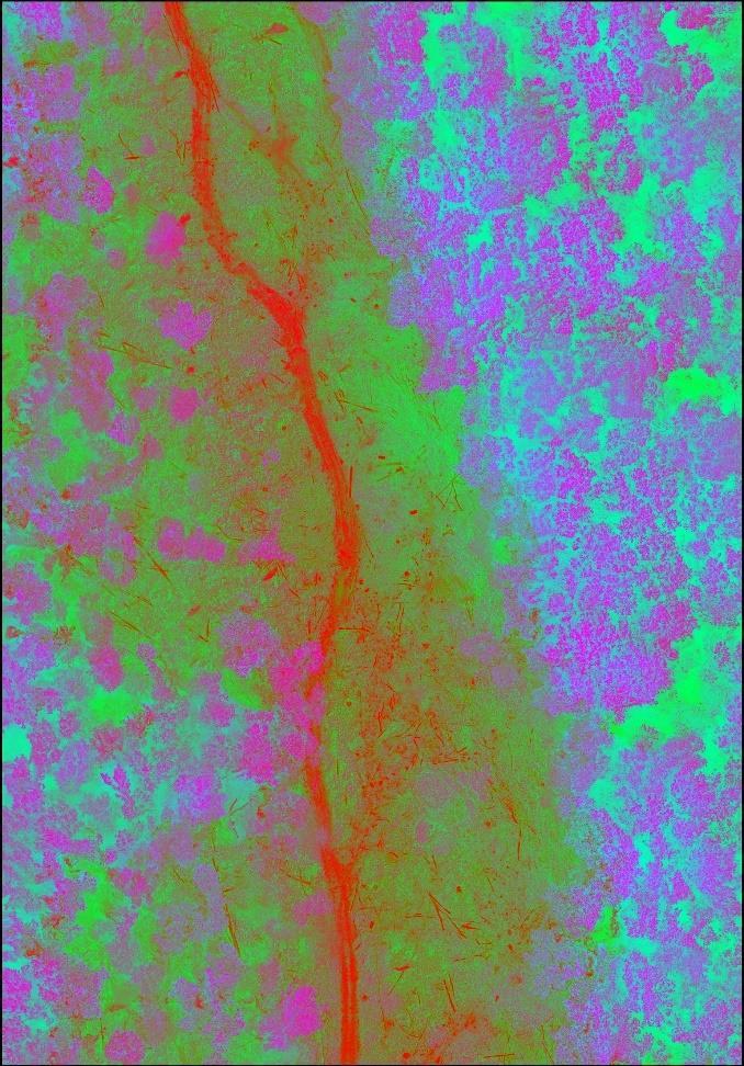
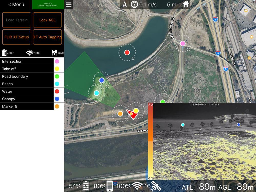
15 What is this?
16 ERROR
17 ERROR
18 ERROR
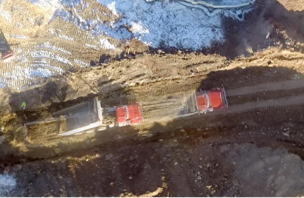
19 ERROR Horizontal and Vertical Error translate to VOLUMETRIC ERROR- even when within specs Change detection can only be done within the accuracy limits of the sensor. Fly the same site twice in the same day with the same control. Check the difference.

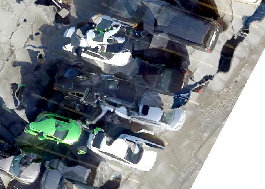
20 WHAT YOU DON T WANT TO SEE
21
22
23
24
25
26
27
28
29


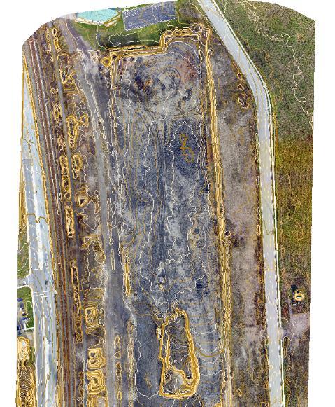
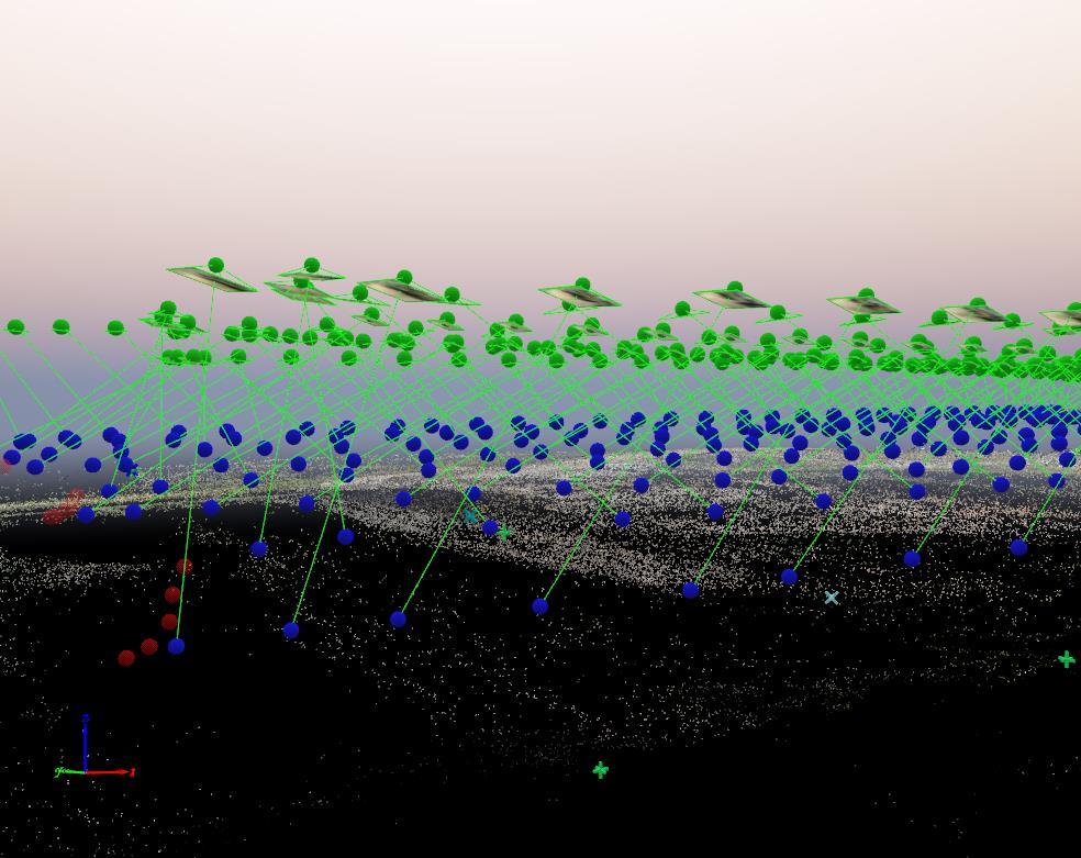
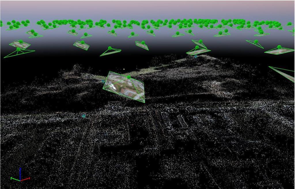
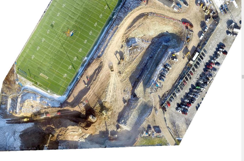
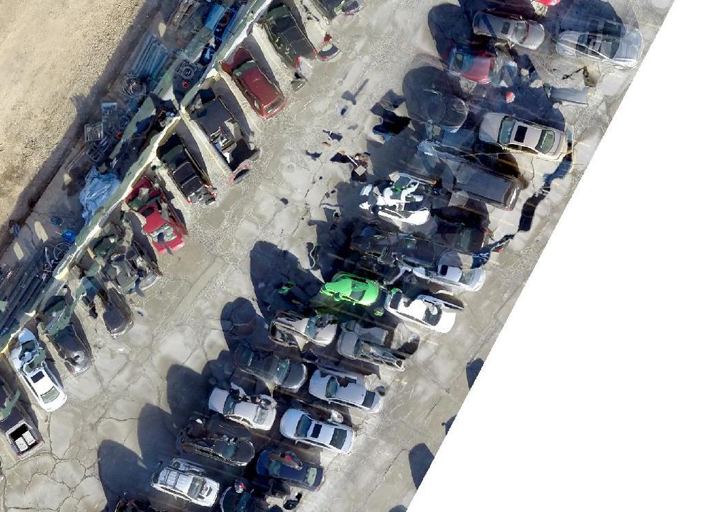
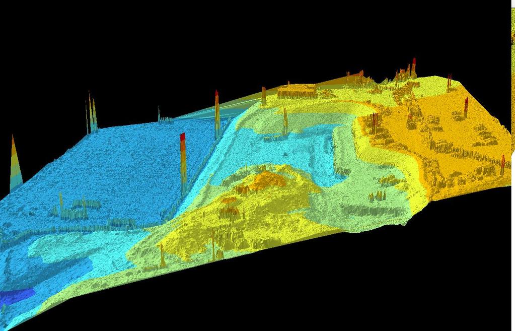
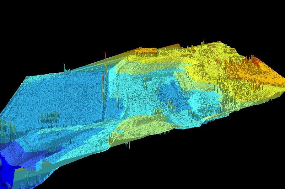
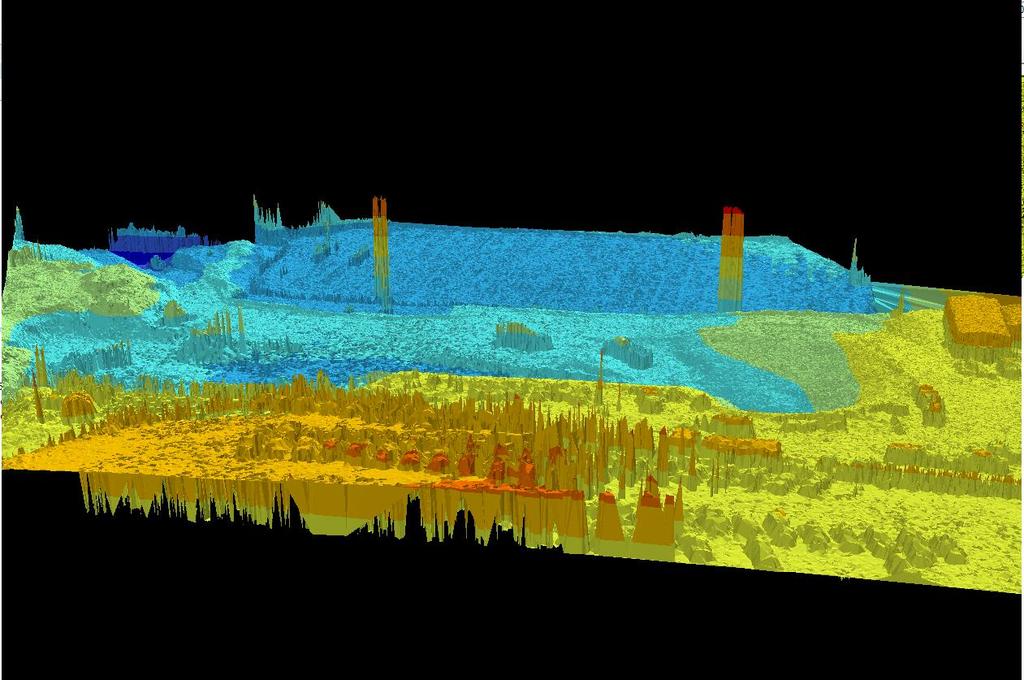
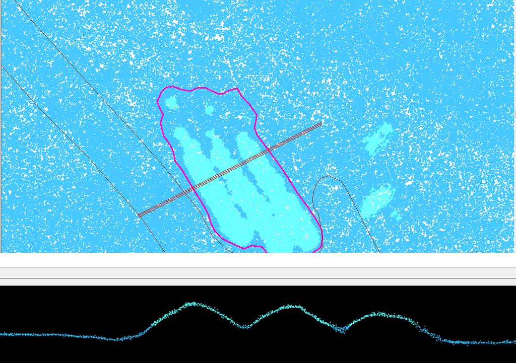
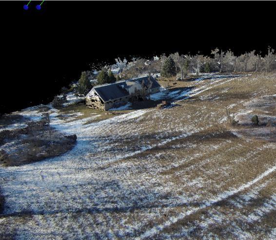
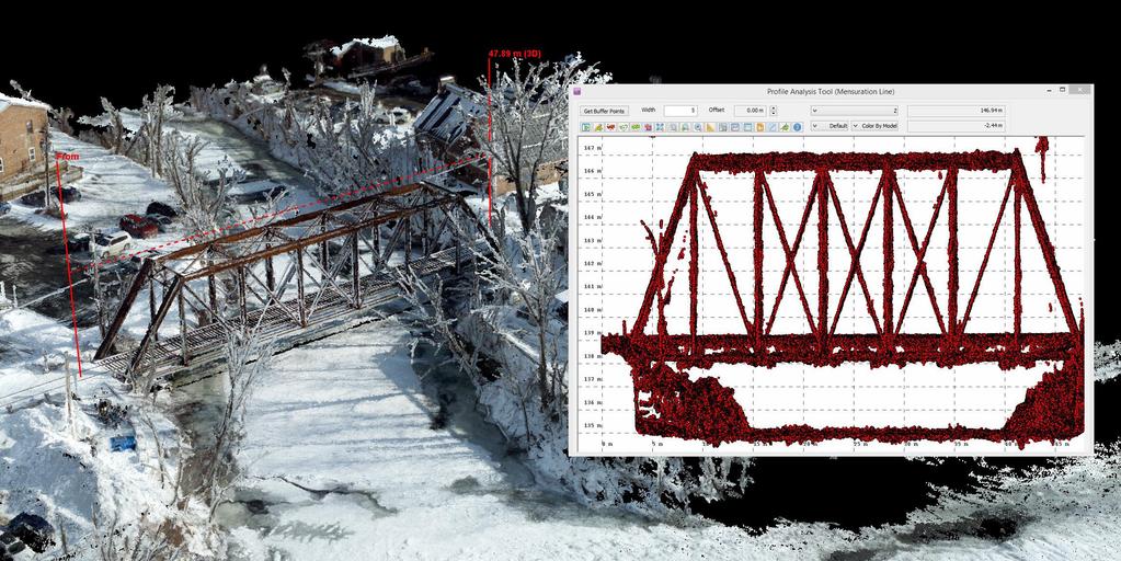
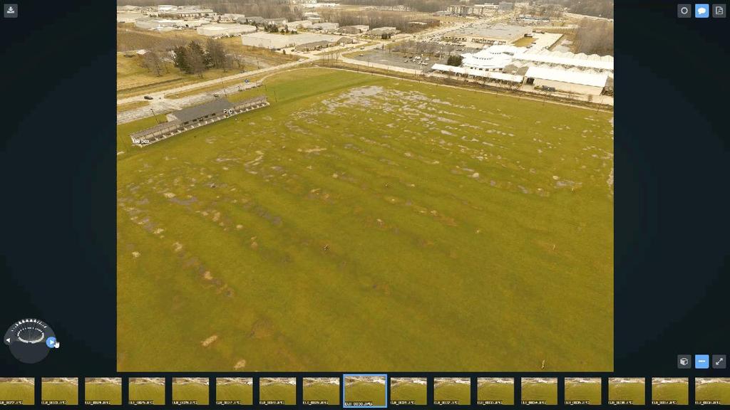
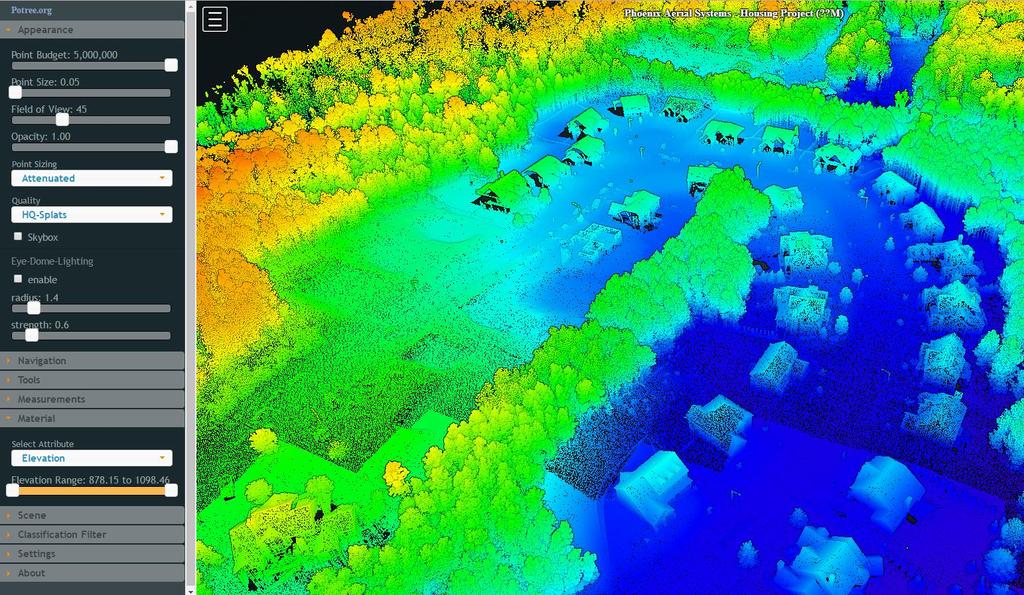
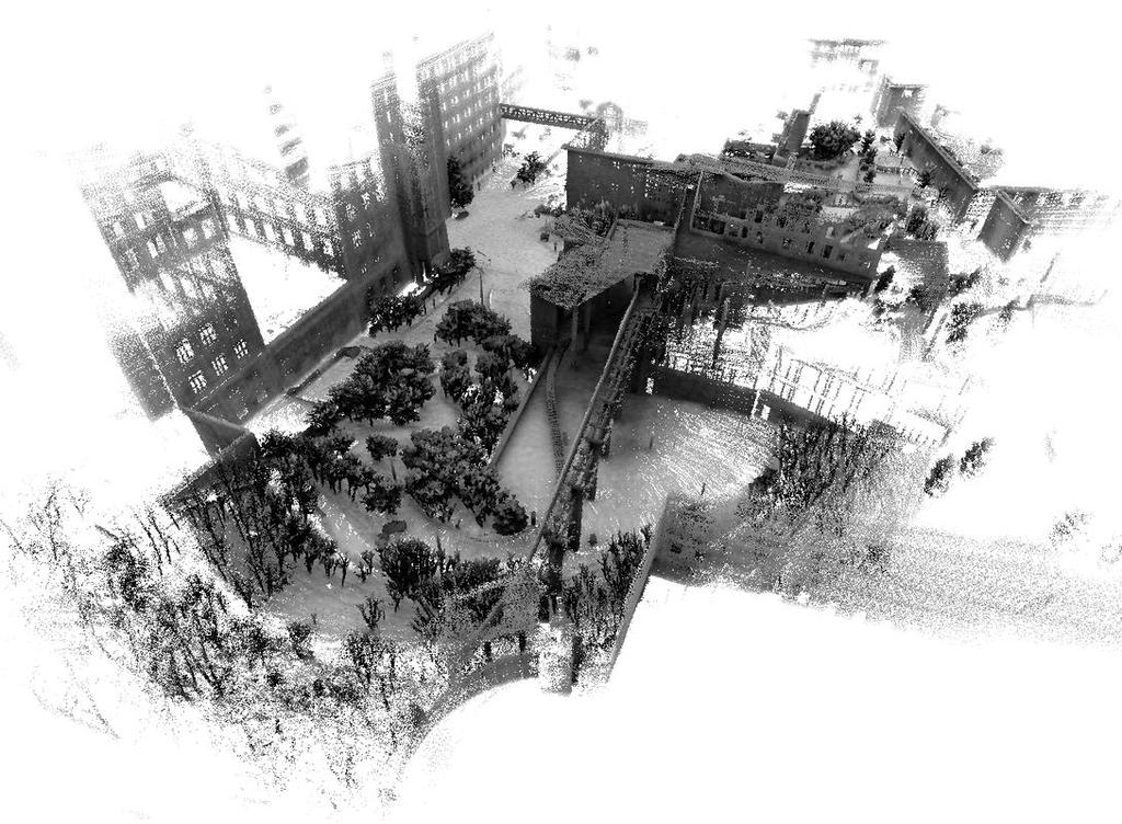
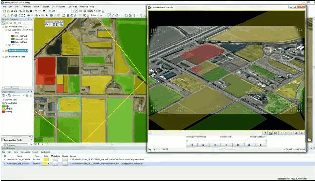
30 PART 3- The Results Screen Shots of Tepper Quad Case Study WHAT YOU DO WANT TO SEE
31

32 Copyright 2016 Spatial Analytix, LLC

33 Copyright 2016 Spatial Analytix, LLC
34

35 Copyright 2016 Spatial Analytix, LLC

36 Copyright 2016 Spatial Analytix, LLC

37 Copyright 2016 Spatial Analytix, LLC

38 Copyright 2016 Spatial Analytix, LLC

39 Copyright 2016 Spatial Analytix, LLC
40

41 Copyright 2016 Spatial Analytix, LLC
42
43


44 Copyright 2016 Spatial Analytix, LLC Thermal IR
45

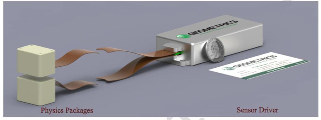
46 Magnetometer
47
48
49
50

51 Thanks! Geodata from suavs Matt Mercurio, GISP GTO, Spatial Analytix
52
UAV Flight Operations for Mapping. Precision. Accuracy. Reliability
 UAV Flight Operations for Mapping Precision. Accuracy. Reliability Part One: Why is Mapping different? Part Two: What about accuracy and precision? Part Three: What is the Workflow? Part Four: AGENDA What
Practical Considerations of UAS Operations on Data Quality
 Practical Considerations of UAS Operations on Data Quality Precision. Accuracy. Reliability OVERVIEW Project Planning and Execution Ground Control Data Processing and Delivery 1 OVERVIEW Get Legal: Section
Overview. 1. Aerial LiDAR in Wisconsin (20 minutes) 2. Demonstration of data in CAD (30 minutes) 3. High Density LiDAR (20 minutes)
 2. Demonstration of data in CAD (30 minutes) 3. High Density LiDAR (20 minutes)") Overview 1. Aerial LiDAR in Wisconsin (20 minutes) 2. Demonstration of data in CAD (30 minutes) 3. High Density LiDAR (20 minutes) 4. Aerial lidar technology advancements (15 minutes) 5. Q & A 1. Aerial
Overview 1. Aerial LiDAR in Wisconsin (20 minutes) 2. Demonstration of data in CAD (30 minutes) 3. High Density LiDAR (20 minutes) 4. Aerial lidar technology advancements (15 minutes) 5. Q & A 1. Aerial
Technical Considerations and Best Practices in Imagery and LiDAR Project Procurement
 Technical Considerations and Best Practices in Imagery and LiDAR Project Procurement Presented to the 2014 WV GIS Conference By Brad Arshat, CP, EIT Date: June 4, 2014 Project Accuracy A critical decision
Quality Control Concepts for LiDAR
 Quality Control Concepts for LiDAR January 24, 2012 Engineering Architecture Design-Build Surveying GeoSpatial Solutions Presentation Objectives Offer realistic and constructive advice for LiDAR project
LIDAR MAPPING FACT SHEET
 1. LIDAR THEORY What is lidar? Lidar is an acronym for light detection and ranging. In the mapping industry, this term is used to describe an airborne laser profiling system that produces location and
Workshops funded by the Minnesota Environment and Natural Resources Trust Fund
 Workshops funded by the Minnesota Environment and Natural Resources Trust Fund Conservation Applications of LiDAR Data Workshops funded by: Minnesota Environment and Natural Resources Trust Fund Presented
2010 LiDAR Project. GIS User Group Meeting June 30, 2010
 2010 LiDAR Project GIS User Group Meeting June 30, 2010 LiDAR = Light Detection and Ranging Technology that utilizes lasers to determine the distance to an object or surface Measures the time delay between
High resolution survey and orthophoto project of the Dosso-Gaya region in the Republic of Niger. by Tim Leary, Woolpert Inc.
 High resolution survey and orthophoto project of the Dosso-Gaya region in the Republic of Niger by Tim Leary, Woolpert Inc. Geospatial Solutions Photogrammetry & Remote Sensing LiDAR Professional Surveying
FEMA s Romance with LiDAR
 Example comparison between LiDAR-derived stream cross section and field surveyed cross section. Many such NCFMP examples demonstrated that the number of surveyed cross sections could be significantly reduced
Introduction Photogrammetry Photos light Gramma drawing Metron measure Basic Definition The art and science of obtaining reliable measurements by mean
 Photogrammetry Review Neil King King and Associates Testing is an art Introduction Read the question Re-Read Read The question What is being asked Answer what is being asked Be in the know Exercise the
Reality Check: Processing LiDAR Data. A story of data, more data and some more data
 Reality Check: Processing LiDAR Data A story of data, more data and some more data Red River of the North Red River of the North Red River of the North Red River of the North Introduction and Background
PROJECT REPORT. Allegany County Acquisition and Classification for FEMA Region 3 FY 12 VA LiDAR. USGS Contract: G12PD00040.
 PROJECT REPORT For the Allegany County Acquisition and Classification for FEMA Region 3 FY 12 VA LiDAR USGS Contract: G12PD00040 Prepared for: United States Geological Survey & Federal Emergency Management
CLOSING REMARKS. Dr. Qassim Abdullah, Woolpert, Inc. ASPRS Positional Accuracy Standards
 CLOSING REMARKS Dr. Qassim Abdullah, Woolpert, Inc. ASPRS Positional Accuracy Standards Understanding the New ASPRS Positional Accuracy Standards for Digital Geospatial Data and its Applicability to UAS-based
Connecticut Association of Assessing Officers CT Statewide GIS Data Acquisition & Services. June 22, :00 am
 Connecticut Association of Assessing Officers 2016 CT Statewide GIS Data Acquisition & Services June 22, 2016 9:00 am Presented by: Shawn Benham, PMP Project Manager ---------------------------- Brad Arshat,
UAS Campus Survey Project
 ARTICLE STUDENTS CAPTURING SPATIAL INFORMATION NEEDS UAS Campus Survey Project Texas A&M University- Corpus Christi, home to the largest geomatics undergraduate programme in Texas, USA, is currently undergoing
LiDAR Engineering and Design Applications. Sample Data
 LiDAR Engineering and Design Applications Sample Data High density LiDAR will return points on any visible part of a structure. Modeling of Existing Structures 2 The distance between any two positions
Volumetric Calculations. Sample Data
 Volumetric Calculations Sample Data Stockpiles of industrial materials are often difficult to measure accurately. LiDAR offers a fast and extremely accurate solution for taking periodical inventory of
Hamilton County Enhances GIS Base Mapping with 1-foot Contours
 Hamilton County Enhances GIS Base Mapping with 1-foot Contours Presented by Larry Stout, Hamilton County GIS Manager Brad Fugate, Woolpert Inc. Today s Presentation Hamilton County s 2004 Base Mapping
AIRBORNE GEIGER MODE LIDAR - LATEST ADVANCEMENTS IN REMOTE SENSING APPLICATIONS RANDY RHOADS
 Place image here (10 x 3.5 ) AIRBORNE GEIGER MODE LIDAR - LATEST ADVANCEMENTS IN REMOTE SENSING APPLICATIONS RANDY RHOADS Geospatial Industry Manager HARRIS.COM #HARRISCORP Harris Company Information SECURITY
An Introduction to Lidar & Forestry May 2013
 An Introduction to Lidar & Forestry May 2013 Introduction to Lidar & Forestry Lidar technology Derivatives from point clouds Applied to forestry Publish & Share Futures Lidar Light Detection And Ranging
Alaska Department of Transportation Roads to Resources Project LiDAR & Imagery Quality Assurance Report Juneau Access South Corridor
 Alaska Department of Transportation Roads to Resources Project LiDAR & Imagery Quality Assurance Report Juneau Access South Corridor Written by Rick Guritz Alaska Satellite Facility Nov. 24, 2015 Contents
Data Acquisition; Maintenance, and Dissemination
 Data Acquisition; Maintenance, and Dissemination Amar Nayegandhi, CP, CMS(RS), GISP Director of Remote Sensing Dewberry December 4, 2014 About MAPPS + MAPPS is the only national association of private
Existing Elevation Data Sets. Quality Level 2 (QL2) Lidar Data Sets. Better Land Characterization More Accurate Results!
 Lidar Data Sets. Better Land Characterization More Accurate Results!") Existing Elevation Data Sets Out of Date: Most > 40 yrs old Data range from 15 yrs old to > 70 yrs old Spatial Resolution: 33 ft (10 m) or coarser Vertical Accuracy: 3.3 ft 6.6 ft (1 2 m) or worse Quality
Existing Elevation Data Sets Out of Date: Most > 40 yrs old Data range from 15 yrs old to > 70 yrs old Spatial Resolution: 33 ft (10 m) or coarser Vertical Accuracy: 3.3 ft 6.6 ft (1 2 m) or worse Quality
Ingesting, Managing, and Using UAV (Drone) Imagery in the ArcGIS Platform
 Imagery in the ArcGIS Platform") Ingesting, Managing, and Using UAV (Drone) Imagery in the ArcGIS Platform Cody A. Benkelman Technical Product Manager Imagery Esri cbenkelman@esri.com Version 2 17 November 2015 This in an Esri draft document
Ingesting, Managing, and Using UAV (Drone) Imagery in the ArcGIS Platform Cody A. Benkelman Technical Product Manager Imagery Esri cbenkelman@esri.com Version 2 17 November 2015 This in an Esri draft document
N.J.P.L.S. An Introduction to LiDAR Concepts and Applications
 N.J.P.L.S. An Introduction to LiDAR Concepts and Applications Presentation Outline LIDAR Data Capture Advantages of Lidar Technology Basics Intensity and Multiple Returns Lidar Accuracy Airborne Laser
QUESTIONS & ANSWERS FOR. ORTHOPHOTO & LiDAR AOT
 QUESTIONS & ANSWERS FOR ORTHOPHOTO & LiDAR AOT Question# 1. Section 3.2 Will the imagery be clipped to the 1000m boundary? If so, what color will be used for null valued pixels? Yes, the imagery will be
Quality Accuracy Professionalism
 GeoWing - who are we? Mapping Data Service Provider Lidar Multispectral Topographic and Planimetric Maps Elevation Models Point Clouds / 3D Models Orthophotography FAA-Authorized UAS Operators WOSB / DBE
Drone2Map for ArcGIS: Bring Drone Imagery into ArcGIS. Will
 Drone2Map for ArcGIS: Bring Drone Imagery into ArcGIS Will Meyers @MeyersMaps A New Window on the World Personal Mapping for Micro-Geographies Accurate High Quality Simple Low-Cost Drone2Map for ArcGIS
Absolute Horizontal Accuracies of Pictometry s Individual Orthogonal Frame Imagery
 A Pictometry International, Corp White Paper Absolute Horizontal Accuracies of Pictometry s Individual Orthogonal Frame Imagery Michael J. Zoltek VP, Surveying & Mapping Pictometry International, Corp
2. POINT CLOUD DATA PROCESSING
 Point Cloud Generation from suas-mounted iphone Imagery: Performance Analysis A. D. Ladai, J. Miller Towill, Inc., 2300 Clayton Road, Suite 1200, Concord, CA 94520-2176, USA - (andras.ladai, jeffrey.miller)@towill.com
Aerial and Mobile LiDAR Data Fusion
 Creating Value Delivering Solutions Aerial and Mobile LiDAR Data Fusion Dr. Srini Dharmapuri, CP, PMP What You Will Learn About LiDAR Fusion Mobile and Aerial LiDAR Technology Components & Parameters Project
Data Acquisition Through the Geospatial Products and Services Contract (GPSC)
") Data Acquisition Through the Geospatial Products and Services Contract (GPSC) Kathryn Yoder GPSC COTR ESRI, 2015 U.S. Department of the Interior U.S. Geological Survey Overview Background Info Acquisition
Data Acquisition Through the Geospatial Products and Services Contract (GPSC) Kathryn Yoder GPSC COTR ESRI, 2015 U.S. Department of the Interior U.S. Geological Survey Overview Background Info Acquisition
LiDAR QA/QC - Quantitative and Qualitative Assessment report -
 LiDAR QA/QC - Quantitative and Qualitative Assessment report - CT T0009_LiDAR September 14, 2007 Submitted to: Roald Haested Inc. Prepared by: Fairfax, VA EXECUTIVE SUMMARY This LiDAR project covered approximately
Wetlands Mapping Consortium 4/18/2012
 USGS LiDAR Guidelines and Base Specification V.13 Wetlands Mapping Consortium 4/18/2012 David F. Maune, Ph.D., CP Dewberry dmaune@dewberry.com Substituting for Karl Heidemann of USGS, primary author of
Todd King, PLS, LEED AP Business Developer
 Todd King, PLS, LEED AP Business Developer TKing@McKimCreed.com 38 YEARS 378 EMPLOYEES ENR Top 500 Design Firm ENR Top 200 Environmental ENR Southeast Engineer Firms POB Geospatial Top 100 Top 50 Trenchless
Satellite surveying. Presentation for ISCWSA. Over 550 global PhotoSat stereo satellite topographic mapping projects.
 Satellite surveying Presentation for ISCWSA Over 550 global PhotoSat stereo satellite topographic mapping projects Basic proposition Satellite surveying has improved to a level where it may be used as
U.S. Geological Survey (USGS) - National Geospatial Program (NGP) and the American Society for Photogrammetry and Remote Sensing (ASPRS)
 - National Geospatial Program (NGP) and the American Society for Photogrammetry and Remote Sensing (ASPRS)") U.S. Geological Survey (USGS) - National Geospatial Program (NGP) and the American Society for Photogrammetry and Remote Sensing (ASPRS) Summary of Research and Development Efforts Necessary for Assuring
U.S. Geological Survey (USGS) - National Geospatial Program (NGP) and the American Society for Photogrammetry and Remote Sensing (ASPRS) Summary of Research and Development Efforts Necessary for Assuring
Drone2Map for ArcGIS: Bring Drone Imagery into ArcGIS
 Drone2Map for ArcGIS: Bring Drone Imagery into ArcGIS Mike Sweeney 1 Drone2Map for ArcGIS Turn Drones into Enterprise Productivity Tools ArcGIS Drone2Map for ArcGIS Create 2D and 3D products from raw drone
Surveying like never before
 CAD functionalities GCP Mapping and Aerial Image Processing Software for Land Surveying Specialists Surveying like never before www.3dsurvey.si Modri Planet d.o.o., Distributors: info@3dsurvey.si +386
Lidar Standards. Chatham County, Georgia. Jason Lee, Noel Perkins and Vincent Grevemberg
 1 Lidar Standards Chatham County, Georgia Jason Lee, Noel Perkins and Vincent Grevemberg 2 SAGIS Lidar Standards Table of Contents Introduction...1 Objective...1.1 Data Description...2 Spatial and Temporal
UAS to GIS Utilizing a low-cost Unmanned Aerial System (UAS) for Coastal Erosion Monitoring
 for Coastal Erosion Monitoring") UAS to GIS Utilizing a low-cost Unmanned Aerial System (UAS) for Coastal Erosion Monitoring A New Window on the World Personal Mapping for Micro-Geographies Accurate High Quality Simple Low-Cost Drone2Map
UAS to GIS Utilizing a low-cost Unmanned Aerial System (UAS) for Coastal Erosion Monitoring A New Window on the World Personal Mapping for Micro-Geographies Accurate High Quality Simple Low-Cost Drone2Map
DOD Airfield Obstruction Collection and Mapping: A GIS Approach. Yaneev Golombek, GISP Tom Cirillo
 DOD Airfield Obstruction Collection and Mapping: A GIS Approach Yaneev Golombek, GISP Tom Cirillo GEOSPATIAL SOLUTIONS July 23, 2015 Engineering Architecture Design-Build Surveying Planning GeoSpatial
SimActive and PhaseOne Workflow case study. By François Riendeau and Dr. Yuri Raizman Revision 1.0
 SimActive and PhaseOne Workflow case study By François Riendeau and Dr. Yuri Raizman Revision 1.0 Contents 1. Introduction... 2 1.1. Simactive... 2 1.2. PhaseOne Industrial... 2 2. Testing Procedure...
Drone2Map: an Introduction. October 2017
 Drone2Map: an Introduction October 2017 Drone2Map: An Introduction Topics: - Introduction to Drone Mapping - Coordinate Systems - Overview of Drone2Map - Basic Drone2Map Workflow - 2D Data Processing -
CLASSIFICATION OF NONPHOTOGRAPHIC REMOTE SENSORS
 CLASSIFICATION OF NONPHOTOGRAPHIC REMOTE SENSORS PASSIVE ACTIVE DIGITAL CAMERA THERMAL (e.g. TIMS) VIDEO CAMERA MULTI- SPECTRAL SCANNERS VISIBLE & NIR MICROWAVE HYPERSPECTRAL (e.g. AVIRIS) SLAR Real Aperture
BLM Fire Project, 2013 QC Analysis Lidar and Orthophoto QC Report November 25th, 2013
 O R E G O N D E P A R T M E N T O F G E O L O G Y 1937 A N D M I N E R A L I N D U S T R I E S Department of Geology & Mineral Industries 800 NE Oregon St, Suite 965 Portland, OR 97232 BLM Fire Project,
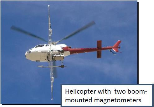
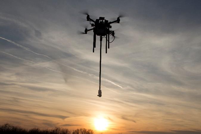
Case Study for Long- Range Beyond Visual Line of Sight Project. March 15, 2018 RMEL Transmission and Planning Conference
 Case Study for Long- Range Beyond Visual Line of Sight Project March 15, 2018 RMEL Transmission and Planning Conference 2014 HDR Architecture, 2016 2014 HDR, Inc., all all rights reserved. Helicopters
Microwave. Infrared. Preprogrammed Chip
 Advanced Technology for Design Mapping and Construction Layout AACE A.A.C.E. Meeting August 5, 2009 Daniel K. Mardock RBF Consulting Survey Manager Registered Land Surveyor Certified Federal Surveyor Arizona
UAV s in Surveying: Integration/processes/deliverables A-Z. 3Dsurvey.si
 UAV s in Surveying: Integration/processes/deliverables A-Z Info@eGPS.net TODAY S PROGRAM Introduction to photogrammetry and 3Dsurvey Theoretical facts about the technology and basics of 3dsurvey Introduction
MODERNIZING THE MODEL FOR STREAMBANK, WATERSHED, STORMWATER MANAGEMENT, AND FLOODPLAIN PLANNING AND RESTORATION
 MODERNIZING THE MODEL FOR STREAMBANK, WATERSHED, STORMWATER MANAGEMENT, AND FLOODPLAIN PLANNING AND RESTORATION April M. Barkasi, PE, CEO, CEDARVILLE Engineering Group LLC, Pottstown, PA PURPOSE The purpose
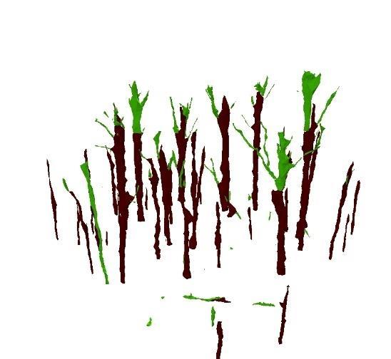
Airborne LiDAR Data Acquisition for Forestry Applications. Mischa Hey WSI (Corvallis, OR)
") Airborne LiDAR Data Acquisition for Forestry Applications Mischa Hey WSI (Corvallis, OR) WSI Services Corvallis, OR Airborne Mapping: Light Detection and Ranging (LiDAR) Thermal Infrared Imagery 4-Band
Airborne LiDAR Data Acquisition for Forestry Applications Mischa Hey WSI (Corvallis, OR) WSI Services Corvallis, OR Airborne Mapping: Light Detection and Ranging (LiDAR) Thermal Infrared Imagery 4-Band
Mayden VP of Business Development Surdex Corporation
 Making Sense of Sensors Randy Mayden, Mayden VP of Business Development Surdex Corporation randym@surdex.com EARLYAERIAL PHOTOGRAPHY 2 FIRSTAERIAL CAMERA 3 AERIAL CAMERA SYSTEM DEVELOPMENT Aerial Camera
Feature Extraction from Imagery & Lidar. Kurt Schwoppe, Esri Mark Romero, Esri Gregory Bacon, Fairfax County
 Feature Extraction from & Lidar Kurt Schwoppe, Esri Mark Romero, Esri Gregory Bacon, Fairfax County Today s Speakers Image Processing Experts and Good Colleagues Kurt Schwoppe Industry Lead Esri Mark Romero
Trends in Digital Aerial Acquisition Systems
 Trends in Digital Aerial Acquisition Systems Ernest Yap Regional Sales Manager, Airborne-Americas eyap@applanix.com 1 Medium Format Digital Cameras Medium Format Digital Cameras Where does the Medium
Municipal Projects in Cambridge Using a LiDAR Dataset. NEURISA Day 2012 Sturbridge, MA
 Municipal Projects in Cambridge Using a LiDAR Dataset NEURISA Day 2012 Sturbridge, MA October 15, 2012 Jeff Amero, GIS Manager, City of Cambridge Presentation Overview Background on the LiDAR dataset Solar
Sandy River, OR Bathymetric Lidar Project, 2012 Delivery QC Analysis Lidar QC Report March 26 th, 2013
 O R E G O N D E P A R T M E N T O F G E O L O G Y A N D M I N E R A L I N D U S T R I E S OLC Sandy River, OR Bathymetric Lidar Project Delivery Acceptance Report. Department of Geology & Mineral Industries
SESSION VIII Panel: Looking Ahead at Factors Influencing the Industry. Moderator Brittany Mabry, University of Arkansas
 SESSION VIII Panel: Looking Ahead at Factors Influencing the Industry Moderator Brittany Mabry, University of Arkansas Futures Panel - Jonathan Rupprecht, Rupprecht Law - Asa Hammond, PreNav - David Yoel,
Rogue River LIDAR Project, 2012 Delivery 1 QC Analysis LIDAR QC Report September 6 th, 2012
 O R E G O N D E P A R T M E N T O F G E O L O G Y A N D M I N E R A L I N D U S T R I E S OLC Rogue River Delivery 1 Acceptance Report. Department of Geology & Mineral Industries 800 NE Oregon St, Suite
Lidar Technical Report
 Lidar Technical Report Oregon Department of Forestry Sites Presented to: Oregon Department of Forestry 2600 State Street, Building E Salem, OR 97310 Submitted by: 3410 West 11st Ave. Eugene, OR 97402 April
Topographic Lidar Data Employed to Map, Preserve U.S. History
 OCTOBER 11, 2016 Topographic Lidar Data Employed to Map, Preserve U.S. History In August 2015, the National Park Service (NPS) contracted Woolpert for the Little Bighorn National Monument Mapping Project
A Method to Create a Single Photon LiDAR based Hydro-flattened DEM
 A Method to Create a Single Photon LiDAR based Hydro-flattened DEM Sagar Deshpande 1 and Alper Yilmaz 2 1 Surveying Engineering, Ferris State University 2 Department of Civil, Environmental, and Geodetic
Unmanned Aerial Systems: A Look Into UAS at ODOT
 Ohio Department of Transportation John R. Kasich, Governor Jerry Wray, Director Unmanned Aerial Systems: Tim Burkholder, PS Mapping Manager Division of Engineering Office of CADD and Mapping Services Kyle
Commercial suas The Right Tool for the Right Job
 Commercial suas The Right Tool for the Right Job Presentation Objectives Overview of current data collection technologies UAS Systems Overview Surveyor 2.0 Project Case Study Mobile LiDAR & suas How Do
Tools Control Point Comparison QA-QC Analysis
 l Darrick Wagg, Support Services Manager 8/15/2012 Revision 1.0 By Darrick Wagg, Support Services Manager An important evaluation to make when performing a QAQC analysis of a LIDAR data set is a control
OLC Wasco County: Delivery One.
 OLC Wasco County: Delivery One www.quantumspatial.com January 2, 2014 Trimble R7 Receiver set up over GPS monument WASCO_02. Data collected for: Oregon Department of Geology and Mineral Industries 800
LIDAR 101 & 2014 MO/AR LIDAR PARTNERS PROJECT. NEMO GIS Workshop
 LIDAR 101 & 2014 MO/AR LIDAR PARTNERS PROJECT NEMO GIS Workshop May 22, 2014 PRESENTER Tim Donze Business Development Surdex Corporation PRESENTATION TOPICS What is LiDAR? Why is LiDAR Valuable? Missouri
Journal Online Jaringan COT POLIPD (JOJAPS) Accuracy Assessment of Height Coordinate Using Unmanned Aerial Vehicle Images Based On Leveling Height
 Accuracy Assessment of Height Coordinate Using Unmanned Aerial Vehicle Images Based On Leveling Height") JOJAPS eissn 2504-8457 Abstract Journal Online Jaringan COT POLIPD (JOJAPS) Accuracy Assessment of Height Coordinate Using Unmanned Aerial Vehicle Images Based On Leveling Height Syamsul Anuar Bin Abu
JOJAPS eissn 2504-8457 Abstract Journal Online Jaringan COT POLIPD (JOJAPS) Accuracy Assessment of Height Coordinate Using Unmanned Aerial Vehicle Images Based On Leveling Height Syamsul Anuar Bin Abu
Trimble Geospatial Division Integrated Solutions for Geomatics professions. Volker Zirn Regional Sales Representative
 Trimble Geospatial Division Integrated Solutions for Geomatics professions Volker Zirn Regional Sales Representative 1 Agenda Trimble GeoSpatial Division Airborne System Solutions Trimble Inpho Software
Geomatic & Information Technologies for Ports and Navigable Waterways. Expanding Our Global Opportunities
 Geomatic & Information Technologies for Ports and Navigable Waterways Airborne Remote Sensing Susan Jackson Tetra Tech Geomatics BD Director Hydrographic Surveying Robert Feldpausch Tetra Tech Principal
2/9/2016. Session Agenda: Implementing new Geospatial Technologies for more efficient data capture
 Implementing new Geospatial Technologies for more efficient data capture Jay Haskamp Applied Geospatial Engineer Steve Richter VP Sales Session Agenda: Today s changing technologies and what lies ahead
TRAINING MATERIAL HOW TO OPTIMIZE ACCURACY WITH CORRELATOR3D
 TRAINING MATERIAL WITH CORRELATOR3D Page2 Contents 1. UNDERSTANDING INPUT DATA REQUIREMENTS... 4 1.1 What is Aerial Triangulation?... 4 1.2 Recommended Flight Configuration... 4 1.3 Data Requirements for
The Reference Library Generating Low Confidence Polygons
 GeoCue Support Team In the new ASPRS Positional Accuracy Standards for Digital Geospatial Data, low confidence areas within LIDAR data are defined to be where the bare earth model might not meet the overall
SLR, Climate Change, Infrastructure Solutions, Adaption and GIS
 Presenters: Francisco D Elia B.S., M.Sc. Geographic Information Systems Franciscodelia@miamibeachfl.gov Nestor Navarro, GISP, MCSA GIS Manager Nestornavarro@miamibeachfl.gov Data Acquisition, Integration
LiDAR data overview. Dr. Keiko Saito Global Facility for Disaster Reduction and Recovery (GFDRR)
") LiDAR data overview Dr. Keiko Saito Global Facility for Disaster Reduction and Recovery (GFDRR) LiDAR (Light Detecting And Ranging) 3D height profile Laser emitted from sensor onboard aircraft to measure
LiDAR data overview Dr. Keiko Saito Global Facility for Disaster Reduction and Recovery (GFDRR) LiDAR (Light Detecting And Ranging) 3D height profile Laser emitted from sensor onboard aircraft to measure
Managing Lidar and Photogrammetric Point Clouds. Lindsay Weitz Cody Benkelman
 and Photogrammetric Point Clouds Lindsay Weitz Cody Benkelman Presentation Context What is lidar, and how does it work? Not this presentation! What can you do with lidar in ArcGIS? What does Esri recommend
VALIDATION OF A NEW 30 METER GROUND SAMPLED GLOBAL DEM USING ICESAT LIDARA ELEVATION REFERENCE DATA
 VALIDATION OF A NEW 30 METER GROUND SAMPLED GLOBAL DEM USING ICESAT LIDARA ELEVATION REFERENCE DATA M. Lorraine Tighe Director, Geospatial Solutions Intermap Session: Photogrammetry & Image Processing
2017 OLC Silver Creek
 2017 OLC Silver Creek December 15, 2017 www.quantumspatial.com Data collected for: Oregon Department of Geology and Mineral Industries 800 NE Oregon Street Suite 965 Portland, OR 97232 Prepared by: Quantum
TAKING FLIGHT JULY/AUGUST 2015 COMMERCIAL UAS ADVANCEMENT BALLOONS THE POOR MAN S UAV? SINGLE PHOTON SENSOR REVIEW VOLUME 5 ISSUE 5
 VOLUME 5 ISSUE 5 JULY/AUGUST 2015 TAKING FLIGHT 14 COMMERCIAL UAS ADVANCEMENT 24 BALLOONS THE POOR MAN S UAV? 30 SINGLE PHOTON SENSOR REVIEW Closing in on 500 authorizations the FAA has expedited the exemption
LiDAR-Maps. and More for. Engineers. TechTime New Mapping Tools for Transportation Engineering. Airborne LiDAR. Digital Cameras
 LiDAR-Maps Airborne LiDAR and More for Digital Cameras Engineers and Their Applications Presenter: Azadeh Koohzare, Ph.D., P.Eng. Project Manager, Geodesy and Geomatics AKoohzare@mcelhanney.com 604-683-8521
UAS for Surveyors. An emerging technology for the Geospatial Industry. Ian Murgatroyd : Technical Sales Rep. Trimble
 UAS for Surveyors An emerging technology for the Geospatial Industry Ian Murgatroyd : Technical Sales Rep. Trimble Project Overview Voyager Quarry, located near Perth Australia Typical of hard rock mines,
APPENDIX E2. Vernal Pool Watershed Mapping
 APPENDIX E2 Vernal Pool Watershed Mapping MEMORANDUM To: U.S. Fish and Wildlife Service From: Tyler Friesen, Dudek Subject: SSHCP Vernal Pool Watershed Analysis Using LIDAR Data Date: February 6, 2014
MassCEC Rooftop Solar Map
 MassCEC Rooftop Solar Map Data and Methods Summary Critigen, LLC Overview The detailed analysis of solar rooftop potential is a multi-step workflow with many facets and input parameters to the analysis
Assimilation of Break line and LiDAR Data within ESRI s Terrain Data Structure (TDS) for creating a Multi-Resolution Terrain Model
 for creating a Multi-Resolution Terrain Model") Assimilation of Break line and LiDAR Data within ESRI s Terrain Data Structure (TDS) for creating a Multi-Resolution Terrain Model Tarig A. Ali Department of Civil Engineering American University of Sharjah,
Assimilation of Break line and LiDAR Data within ESRI s Terrain Data Structure (TDS) for creating a Multi-Resolution Terrain Model Tarig A. Ali Department of Civil Engineering American University of Sharjah,
Burns, OR LIDAR Project, 2011 Delivery QC Analysis LIDAR QC Report February 13th, 2012
 O R E G O N D E P A R T M E N T O F G E O L O G Y A N D M I N E R A L I N D U S T R I E S OLC Burns, OR Delivery Acceptance Report. Department of Geology & Mineral Industries 800 NE Oregon St, Suite 965
Coastal Survey of archaeological sites using drones
 Coastal Survey of archaeological sites using drones In Poseidon s Realm XXI Underwater archaeology - interdisciplinary approaches and technical innovations Dimitrios Skarlatos, Savvidou Eleni Photogrammetric
Central Coast LIDAR Project, 2011 Delivery 1 QC Analysis LIDAR QC Report February 17 th, 2012
 O R E G O N D E P A R T M E N T O F G E O L O G Y A N D M I N E R A L I N D U S T R I E S OLC Central Coast Delivery 1 Acceptance Report. Department of Geology & Mineral Industries 800 NE Oregon St, Suite
Baseline Specifications for Orthophotography and LiDAR Florida GIS
 Florida GIS Baseline Specifications for Orthophotography and LiDAR Revision History Baseline Specifications for Orthophotography and LiDAR Version Date Description 0.9 10/17/06 Draft released 0.9.1 04/04/07
The Use of UAS in modern field work
 The Use of UAS in modern field work SplitRS 2015, Thessaloniki, GREECE 22/05/2015 1 ebee by sensefly Swiss-made UAV Fully autonomous flight Suitable for: Mapping, GIS, Surveying Precision Agriculture Environmental
Outline of Presentation. Introduction to Overwatch Geospatial Software Feature Analyst and LIDAR Analyst Software
 Outline of Presentation Automated Feature Extraction from Terrestrial and Airborne LIDAR Presented By: Stuart Blundell Overwatch Geospatial - VLS Ops Co-Author: David W. Opitz Overwatch Geospatial - VLS
TrueOrtho with 3D Feature Extraction
 TrueOrtho with 3D Feature Extraction PCI Geomatics has entered into a partnership with IAVO to distribute its 3D Feature Extraction (3DFE) software. This software package compliments the TrueOrtho workflow
UTILIZACIÓN DE DATOS LIDAR Y SU INTEGRACIÓN CON SISTEMAS DE INFORMACIÓN GEOGRÁFICA
 UTILIZACIÓN DE DATOS LIDAR Y SU INTEGRACIÓN CON SISTEMAS DE INFORMACIÓN GEOGRÁFICA Aurelio Castro Cesar Piovanetti Geographic Mapping Technologies Corp. (GMT) Consultores en GIS info@gmtgis.com Geographic
Windstorm Simulation & Modeling Project
 Windstorm Simulation & Modeling Project Airborne LIDAR Data and Digital Elevation Models in Broward County, Florida Data Quality Report and Description of Deliverable Datasets Prepared for: The Broward
LiForest Software White paper. TRGS, 3070 M St., Merced, 93610, Phone , LiForest
 0 LiForest LiForest is a platform to manipulate large LiDAR point clouds and extract useful information specifically for forest applications. It integrates a variety of advanced LiDAR processing algorithms
Lecture 23 - LiDAR. GEOL 452/552 - GIS for Geoscientists I. Scanning Lidar. 30 m DEM. Lidar representations:
 GEOL 452/552 - GIS for Geoscientists I Lecture 23 - LiDAR LiDAR - some background (thanks to Chris Kahle, DNR) Converting Lidar point data to a raster Look at online lidar data for Iowa (1m hillshaded)
Light Detection and Ranging (LiDAR)
") Light Detection and Ranging (LiDAR) http://code.google.com/creative/radiohead/ Types of aerial sensors passive active 1 Active sensors for mapping terrain Radar transmits microwaves in pulses determines
Light Detection and Ranging (LiDAR) http://code.google.com/creative/radiohead/ Types of aerial sensors passive active 1 Active sensors for mapping terrain Radar transmits microwaves in pulses determines
2017 OLC Siskiyou. September 27,
 2017 OLC Siskiyou September 27, 2017 www.quantumspatial.com Data collected for: Oregon Department of Geology and Mineral Industries 800 NE Oregon Street Suite 965 Portland, OR 97232 Prepared by: Quantum
Quality Assurance and Quality Control Procedures for Survey-Grade Mobile Mapping Systems
 Quality Assurance and Quality Control Procedures for Survey-Grade Mobile Mapping Systems Latin America Geospatial Forum November, 2015 Agenda 1. Who is Teledyne Optech 2. The Lynx Mobile Mapper 3. Mobile
Lidar Talking Points Status of lidar collection in Pennsylvania Estimated cost and timeline
 Lidar Talking Points Pennsylvania has an immediate need for new lidar (topographic) data coverage. Some uses of the data are enumerated later in this document. USGS has calculated an average return on
years Mapping the World We are an all-terrain mapping provider.
 We are Fugro 60 Mapping years the World We are an all-terrain mapping provider. 2 Global network of offices and facilities to offer unified support for projects on any scale. 10,500 employees 175 offices