Trends in Digital Aerial Acquisition Systems
|
|
|
- Jeffry Jacobs
- 5 years ago
- Views:
Transcription

1 Trends in Digital Aerial Acquisition Systems Ernest Yap Regional Sales Manager, Airborne-Americas
2 1 Medium Format Digital Cameras
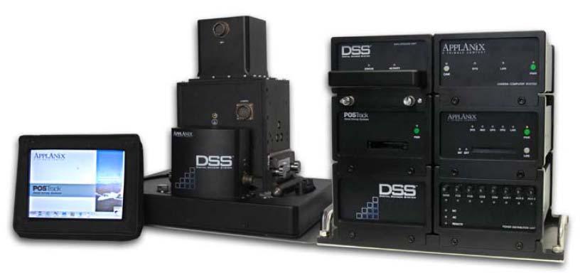
3
4 Medium Format Digital Cameras Where does the Medium Format Camera fit into the industry? Does not replace the large format film cameras (RC30, LMK, RMK) Does not compete with large format digital cameras (UltraCam, DMC) Large formats try to acquire the largest areas and largest coverage The Medium Format cameras work in conjunction with large format cameras Medium-Format cameras smaller footprint (smaller area coverage) specific area data capture
5 Medium Format Digital Cameras What are the applications with a smaller footprint? Small area orthos Corridor mapping Not trying to get the largest area and widest coverage Medium format digital cameras do not replace the film camera the base-to-height ratio cannot compare Medium format cameras are meant as ortho-machines
6 DSS Market Segments: Applications Area Mapping Corridor Mapping Rapid Response Urban Planning County Mapping Insurance Roads and Highways Powerline Pipeline Shoreline Disaster Assessment Military Law Enforcement Facilities and Security
7 Medium Format Digital Cameras Smaller footprint smaller image size faster processing time = near real-time ortho production is here (e.g. Applanix DSS Rapid Ortho) Medium format cameras are generally smaller Can be installed in helicopters and small planes Fly lower Smaller aircraft reduce operation costs
8 With so many up and coming medium format cameras, you have to be careful that it is mapping quality Applanix DSS has been certified by the USGS
9 2 Sensor Fusion
10 Sensor Fusion: Medium-Format Cameras with LIDAR LIDAR Why would you integrate medium format cameras with LIDAR? Key reason: A large amount of detailed information can be collected in a very short amount of time LIDAR: for Digital Elevation Models Digital Aerial Cameras (Mapping grade) for imagery
11 Sensor Fusion: Medium-Format Cameras with LIDAR LIDAR Sensor-Fusion will get you survey data, structural information, topographical details and digital imagery all with common georeferencing attributes Why is the large-format camera incompatible with LIDAR? The ground coverage between both sensors are different at the same altitude. Data has to be captured at different altitudes OR, Multiple LIDAR passes would have to be flown to match the imagery coverage Large format cameras are faced with size and weight restrictions, which restricts the type of aircraft platform
12 Sensor Fusion: Medium-Format Cameras with LIDAR LIDAR The Field of View of a Medium format camera and LIDAR are nearly the same One flight same area coverage two datasets = less operation costs Sensor-Fusion uses the same GNSS/INS: A key component to a multi-sensor system shares the same GNSS/INS for Direct Georeferencing to get position and orientation for both LIDAR and Camera sensors


")
13 Sensor-Fusion: DSS Integration with LIDAR DSS is currently flying on LIDAR systems Working with LIDAR Manufacturers to improve: Software integration (workflow, control) Hardware integration (ie smaller payloads etc.)
14 Multi-Sensor System: More Sensors Integration of DSS with Multiple Sensors Hyperspectral Multispectral Thermal Medium Format Digital Cameras LIDAR Imagery and LIDAR can provide a High Resolution Base Map and DEM for registration for lower resolution hyperspectral or thermal data
15 3 GNSS/INS
16 GNSS/INS GNSS/INS has reached limits where higher accuracy will not improve sensor performance for aerial surveys The real trend at this point is using GNSS/INS post-processing software to improves the methods of performing aerial surveys and in project setup conditions
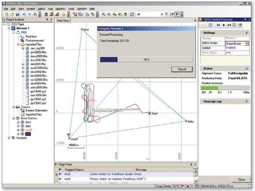
17
18 POSPac MMS: a NEW approach to Airborne Mapping and Surveying FLY FARTHER: The distance to nearest reference station extended well beyond 30 km (19 mi) up to 70 km, 100 km between reference baselines FLY SHARPER: Ability to fly degree banked turns Reduces the need to start close to a reference station to initialize ambiguities Time to fix ambiguities is significantly reduced 18
19 POSPac MMS increases the accuracy and reliability of positioning in an airborne environment Applanix SmartBase TM Uses Trimble VRS TM Technology in post-processing mode by taking advantage of the GPS CORS networks or VRS subscription services Support augmentation to public GPS networks by supporting use of dedicated reference station data Applanix IN-Fusion TM Technology Tightly-coupled GNSS inertial integration Inertial data is used to solve for GPS ambiguities Retains memory of ambiguity during loss of satellites Results in ultra-fast re-initialization of ambiguity after loss 19
20 Ernest Yap Regional Sales Manager
APPLANIX DIRECT GEOREFERENCING FOR AIRBORNE MAPPING. and FLIGHT MANAGEMENT SYSTEMS. The Better Way to Reduce the Cost of Airborne Mapping
 APPLANIX DIRECT GEOREFERENCING and FLIGHT MANAGEMENT SYSTEMS FOR AIRBORNE MAPPING The Better Way to Reduce the Cost of Airborne Mapping capture everything. precisely. Applanix Direct Georeferencing and
Terrestrial GPS setup Fundamentals of Airborne LiDAR Systems, Collection and Calibration. JAMIE YOUNG Senior Manager LiDAR Solutions
 Terrestrial GPS setup Fundamentals of Airborne LiDAR Systems, Collection and Calibration JAMIE YOUNG Senior Manager LiDAR Solutions Topics Terrestrial GPS reference Planning and Collection Considerations
LiDAR & Orthophoto Data Report
 LiDAR & Orthophoto Data Report Tofino Flood Plain Mapping Data collected and prepared for: District of Tofino, BC 121 3 rd Street Tofino, BC V0R 2Z0 Eagle Mapping Ltd. #201 2071 Kingsway Ave Port Coquitlam,
Integrated Multi-Source LiDAR and Imagery
 Figure 1: AirDaC aerial scanning system Integrated Multi-Source LiDAR and Imagery The derived benefits of LiDAR scanning in the fields of engineering, surveying, and planning are well documented. It has
a Geo-Odyssey of UAS LiDAR Mapping Henno Morkel UAS Segment Specialist DroneCon 17 May 2018
 a Geo-Odyssey of UAS LiDAR Mapping Henno Morkel UAS Segment Specialist DroneCon 17 May 2018 Abbreviations UAS Unmanned Aerial Systems LiDAR Light Detection and Ranging UAV Unmanned Aerial Vehicle RTK Real-time
LiDAR data overview. Dr. Keiko Saito Global Facility for Disaster Reduction and Recovery (GFDRR)
") LiDAR data overview Dr. Keiko Saito Global Facility for Disaster Reduction and Recovery (GFDRR) LiDAR (Light Detecting And Ranging) 3D height profile Laser emitted from sensor onboard aircraft to measure
LiDAR data overview Dr. Keiko Saito Global Facility for Disaster Reduction and Recovery (GFDRR) LiDAR (Light Detecting And Ranging) 3D height profile Laser emitted from sensor onboard aircraft to measure
Accuracy Assessment of POS AVX 210 integrated with the Phase One ixu150
 White Paper 3/17/2016 Accuracy Assessment of POS AVX 210 integrated with the Phase One ixu150 Omer Mian, Joe Hutton, Greg Lipa, James Lutes, Damir Gumerov, Srdjan Sobol Applanix, William Chan - GeoPixel
2010 LiDAR Project. GIS User Group Meeting June 30, 2010
 2010 LiDAR Project GIS User Group Meeting June 30, 2010 LiDAR = Light Detection and Ranging Technology that utilizes lasers to determine the distance to an object or surface Measures the time delay between
Mayden VP of Business Development Surdex Corporation
 Making Sense of Sensors Randy Mayden, Mayden VP of Business Development Surdex Corporation randym@surdex.com EARLYAERIAL PHOTOGRAPHY 2 FIRSTAERIAL CAMERA 3 AERIAL CAMERA SYSTEM DEVELOPMENT Aerial Camera
APPLANIX PRODUCTS AND SOLUTIONS FOR MOBILE MAPPING AND POSITIONING CAPTURE EVERYTHING. POSPac MMS HYDRO 08 November 2008
 APPLANIX CAPTURE EVERYTHING POSPac MMS HYDRO 08 November 2008 Accurate Post Processed Position & Orientation For Modern Port Survey Operations. Increasing use of sonar & laser survey equipment with sub-centimetre
An Overview of Applanix.
 An Overview of Applanix The Company The Industry Leader in Developing Aided Inertial Technology Founded on Canadian Aerospace and Defense Industry Expertise Providing Precise Position and Orientation Systems
2/9/2016. Session Agenda: Implementing new Geospatial Technologies for more efficient data capture
 Implementing new Geospatial Technologies for more efficient data capture Jay Haskamp Applied Geospatial Engineer Steve Richter VP Sales Session Agenda: Today s changing technologies and what lies ahead
SPAR, ELMF 2013, Amsterdam. Laser Scanning on the UK Highways Agency Network. Hamish Grierson Blom Uk
 SPAR, ELMF 2013, Amsterdam Laser Scanning on the UK Highways Agency Network Hamish Grierson Blom Uk www.blomasa.com www.blom-uk.co.uk Blom UK Part of the Blom Group Blom Group - Europe s largest aerial
UAS Campus Survey Project
 ARTICLE STUDENTS CAPTURING SPATIAL INFORMATION NEEDS UAS Campus Survey Project Texas A&M University- Corpus Christi, home to the largest geomatics undergraduate programme in Texas, USA, is currently undergoing
Applanix POS AV TM and POSTrack TM : Frequently Asked Questions
 Applanix POS AV TM and POSTrack TM : Frequently Asked Questions 1) What is a Direct Georeferencing System? A direct georeferencing (DG) system provides the ability to directly relate the data collected
GEO 6895: Airborne laser scanning - workflow, applications, value. Christian Hoffmann
 GEO 6895: Airborne laser scanning - workflow, applications, value. Christian Hoffmann Agenda Why LiDAR? The value of an end-to-end workflow The Trimble AX-Series Data processing & modelling Information
Aerial and Mobile LiDAR Data Fusion
 Creating Value Delivering Solutions Aerial and Mobile LiDAR Data Fusion Dr. Srini Dharmapuri, CP, PMP What You Will Learn About LiDAR Fusion Mobile and Aerial LiDAR Technology Components & Parameters Project
LIDAR MAPPING FACT SHEET
 1. LIDAR THEORY What is lidar? Lidar is an acronym for light detection and ranging. In the mapping industry, this term is used to describe an airborne laser profiling system that produces location and
N.J.P.L.S. An Introduction to LiDAR Concepts and Applications
 N.J.P.L.S. An Introduction to LiDAR Concepts and Applications Presentation Outline LIDAR Data Capture Advantages of Lidar Technology Basics Intensity and Multiple Returns Lidar Accuracy Airborne Laser
Direct Georeferencing and Flight Management Solutions for Airborne Mapping
 CAPTURE EVERYTHING Direct Georeferencing and Flight Management Solutions for Airborne Mapping Because The World s Not Standing Still. Applanix Products and Solutions accurately and reliably, capture and
Absolute Horizontal Accuracies of Pictometry s Individual Orthogonal Frame Imagery
 A Pictometry International, Corp White Paper Absolute Horizontal Accuracies of Pictometry s Individual Orthogonal Frame Imagery Michael J. Zoltek VP, Surveying & Mapping Pictometry International, Corp
Leica ALS80 Airborne Laser Scanners Performance for every Application
 Leica ALS80 Airborne Laser Scanners Performance for every Application Three Models, One Result. Highest Productivity in all Applications. Imagine an affordable city-mapping LIDAR system with an industry-leading
A SENSOR FUSION APPROACH TO COASTAL MAPPING
 A SENSOR FUSION APPROACH TO COASTAL MAPPING Maryellen Sault, NOAA, National Ocean Service, National Geodetic Survey Christopher Parrish, NOAA, National Ocean Service, National Geodetic Survey Stephen White,
Leica ALS70. Airborne Laser Scanners Performance for diverse Applications
 Leica ALS70 Airborne Laser Scanners Performance for diverse Applications Three Models, One Result. Highest Productivity in all Applications. Imagine an affordable 500 khz pulse rate city-mapping LIDAR
ALS40 Airborne Laser Scanner
 ALS40 Airborne Laser Scanner Airborne LIDAR for Professionals High Performance Laser Scanning Direct Measurement of Ground Surface from the Air The ALS40 Airborne Laser Scanner measures the topography
TIMMS : FAST, ACCURATE & COST-EFFECTIVE INDOOR MAPPING
 TIMMS : FAST, ACCURATE & COST-EFFECTIVE INDOOR MAPPING Designed for ease-of-use and maneuverability, TIMMS is a high-productivity tool for accurately measuring, georeferencing and modeling interior spaces
2-4 April 2019 Taets Art and Event Park, Amsterdam CLICK TO KNOW MORE
 Co-Host Host 2-4 April 2019 Taets Art and Event Park, Amsterdam CLICK TO KNOW MORE Presentation Outline review modern survey methodologies available to support railway requirements measuring everything
Remote Sensing Sensor Integration
 Remote Sensing Sensor Integration Erica Tharp LiDAR Supervisor Table of Contents About 3001 International Inc Remote Sensing Platforms Why Sensor Integration? Technical Aspects of Sensor Integration Limitations
An Introduction to Lidar & Forestry May 2013
 An Introduction to Lidar & Forestry May 2013 Introduction to Lidar & Forestry Lidar technology Derivatives from point clouds Applied to forestry Publish & Share Futures Lidar Light Detection And Ranging
LiDAR Engineering and Design Applications. Sample Data
 LiDAR Engineering and Design Applications Sample Data High density LiDAR will return points on any visible part of a structure. Modeling of Existing Structures 2 The distance between any two positions
Volumetric Calculations. Sample Data
 Volumetric Calculations Sample Data Stockpiles of industrial materials are often difficult to measure accurately. LiDAR offers a fast and extremely accurate solution for taking periodical inventory of
Geometric Accuracy Assessment of Unmanned Digital Cameras and LiDAR Payloads
 Geometric Accuracy Assessment of Unmanned Digital Cameras and LiDAR Payloads Mohamed M. R. Mostafa, Stefanie Van-Wierts, and Vi Huynh Microdrones, 2911 Rue Du Meunier, Vaudreuil-Dorion, J7V 8P2 Quebec,
Hamilton County Enhances GIS Base Mapping with 1-foot Contours
 Hamilton County Enhances GIS Base Mapping with 1-foot Contours Presented by Larry Stout, Hamilton County GIS Manager Brad Fugate, Woolpert Inc. Today s Presentation Hamilton County s 2004 Base Mapping
SimActive and PhaseOne Workflow case study. By François Riendeau and Dr. Yuri Raizman Revision 1.0
 SimActive and PhaseOne Workflow case study By François Riendeau and Dr. Yuri Raizman Revision 1.0 Contents 1. Introduction... 2 1.1. Simactive... 2 1.2. PhaseOne Industrial... 2 2. Testing Procedure...
STARTING WITH DRONES. Data Collection and Remote Sensing with UAVs, etc. Dr. Bill Hazelton LS
 STARTING WITH DRONES Data Collection and Remote Sensing with UAVs, etc. Dr. Bill Hazelton LS What this Talk is About UAV-based data acquisition: What you need to get involved Processes in getting spatial
Case Study for Long- Range Beyond Visual Line of Sight Project. March 15, 2018 RMEL Transmission and Planning Conference
 Case Study for Long- Range Beyond Visual Line of Sight Project March 15, 2018 RMEL Transmission and Planning Conference 2014 HDR Architecture, 2016 2014 HDR, Inc., all all rights reserved. Helicopters
A COMPARISON OF STANDARD FIXED-WING VS MULTIROTOR DRONE PHOTOGRAMMETRY SURVEYS
 A COMPARISON OF STANDARD FIXED-WING VS MULTIROTOR DRONE PHOTOGRAMMETRY SURVEYS Dr Steve Harwin, UAV Operations, Tas KEY QUESTIONS What detail, scale and accuracy are needed? For change analysis the data
Leica Systems Overview
 RC30 AERIAL CAMERA SYSTEM Leica Systems Overview The Leica RC30 aerial film camera is the culmination of decades of development, started with Wild's first aerial camera in the 1920s. Beautifully engineered
The Applanix Approach to GPS/INS Integration
 Lithopoulos 53 The Applanix Approach to GPS/INS Integration ERIK LITHOPOULOS, Markham ABSTRACT The Position and Orientation System for Direct Georeferencing (POS/DG) is an off-the-shelf integrated GPS/inertial
Quinnipiac Post Flight Aerial Acquisition Report
 Quinnipiac Post Flight Aerial Acquisition Report August 2011 Post-Flight Aerial Acquisition and Calibration Report FEMA REGION 1 Quinnipiac Watershed, Connecticut, Massachusesetts FEDERAL EMERGENCY MANAGEMENT
About LIDAR Data. What Are LIDAR Data? How LIDAR Data Are Collected
 1 of 6 10/7/2006 3:24 PM Project Overview Data Description GIS Tutorials Applications Coastal County Maps Data Tools Data Sets & Metadata Other Links About this CD-ROM Partners About LIDAR Data What Are
Assessing the Performance of Different Direct-Georeferencing with Large Format Digital Cameras
 Assessing the Performance of Different Direct-Georeferencing with Large Format Digital Cameras Civil and Environment Engineering Department, Mu ta University, Mu ta, Al-Karak, Jordan, 61710. E.mail: khaldoun_q@hotamil.com
High resolution survey and orthophoto project of the Dosso-Gaya region in the Republic of Niger. by Tim Leary, Woolpert Inc.
 High resolution survey and orthophoto project of the Dosso-Gaya region in the Republic of Niger by Tim Leary, Woolpert Inc. Geospatial Solutions Photogrammetry & Remote Sensing LiDAR Professional Surveying
UAV Surveying II. Precision. Accuracy. Reliability
 UAV Surveying II Precision. Accuracy. Reliability Part One: Project Lifecycle Deliverables Part Two: Evaluation of UAV Data Accuracy and Examples of Error Part Three: AGENDA Review of Results Examples
High Resolution Laserscanning, not only for 3D-City Models
 Lohr 133 High Resolution Laserscanning, not only for 3D-City Models UWE LOHR, Ravensburg ABSTRACT The TopoSys laserscanner system is designed to produce digital elevation models (DEMs) of the environment
Trimble Indoor Mobile Mapping Solution
 Kevin Perkins Applanix Corp. NATIONAL SURVEYING, MAPPING & GEOSPATIAL CONFERENCE - MARCH 13-17, 2017 Trimble Indoor Mobile Mapping Solution Why Indoor Mapping? The need: As-built maps/models of indoor
AN INTEGRATED SENSOR ORIENTATION SYSTEM FOR AIRBORNE PHOTOGRAMMETRIC APPLICATIONS
 AN INTEGRATED SENSOR ORIENTATION SYSTEM FOR AIRBORNE PHOTOGRAMMETRIC APPLICATIONS M. J. Smith a, *, N. Kokkas a, D.W.G. Park b a Faculty of Engineering, The University of Nottingham, Innovation Park, Triumph
The YellowScan Surveyor: 5cm Accuracy Demonstrated
 The YellowScan Surveyor: 5cm Accuracy Demonstrated Pierre Chaponnière1 and Tristan Allouis2 1 Application Engineer, YellowScan 2 CTO, YellowScan Introduction YellowScan Surveyor, the very latest lightweight
Sensor Integration and Image Georeferencing for Airborne 3D Mapping Applications
 Sensor Integration and Image Georeferencing for Airborne 3D Mapping Applications By Sameh Nassar and Naser El-Sheimy University of Calgary, Canada Contents Background INS/GPS Integration & Direct Georeferencing
Airborne Laser Survey Systems: Technology and Applications
 Abstract Airborne Laser Survey Systems: Technology and Applications Guangping HE Lambda Tech International, Inc. 2323B Blue Mound RD., Waukesha, WI-53186, USA Email: he@lambdatech.com As mapping products
Mobile LiDAR for Ground Applications. Spar 2006, March Paul Mrstik, Terrapoint Canada Inc. Craig Glennie, Terrapoint USA LLC
 Mobile LiDAR for Ground Applications Spar 2006, March 27 2006 Paul Mrstik, Terrapoint Canada Inc. Craig Glennie, Terrapoint USA LLC Agenda Introduction to Terrapoint What is mobile LiDAR? Advantages of
MAPPS 2013 Winter Conference 2013 Cornerstone Mapping, Inc. 1
 MAPPS 2013 Winter Conference 2013 Cornerstone Mapping, Inc. 1 What is Thermal Imaging? Infrared radiation is perceived as heat Heat is a qualitative measure of temperature Heat is the transfer of energy
UAV Flight Operations for Mapping. Precision. Accuracy. Reliability
 UAV Flight Operations for Mapping Precision. Accuracy. Reliability Part One: Why is Mapping different? Part Two: What about accuracy and precision? Part Three: What is the Workflow? Part Four: AGENDA What
TAKING FLIGHT JULY/AUGUST 2015 COMMERCIAL UAS ADVANCEMENT BALLOONS THE POOR MAN S UAV? SINGLE PHOTON SENSOR REVIEW VOLUME 5 ISSUE 5
 VOLUME 5 ISSUE 5 JULY/AUGUST 2015 TAKING FLIGHT 14 COMMERCIAL UAS ADVANCEMENT 24 BALLOONS THE POOR MAN S UAV? 30 SINGLE PHOTON SENSOR REVIEW Closing in on 500 authorizations the FAA has expedited the exemption
Airborne Kinematic Positioning and Attitude Determination Without Base Stations
 Airborne Kinematic Positioning and Attitude Determination Without Base Stations Mohamed M. R. Mostafa and Joseph Hutton Applanix Corporation 85 Leek Cr., Richmond Hill Ontario, Canada L4B 3B3 Phone: (905)
GIS Data Collection. This chapter reviews the main methods of GIS data capture and transfer and introduces key practical management issues.
 9 GIS Data Collection OVERVIEW This chapter reviews the main methods of GIS data capture and transfer and introduces key practical management issues. It distinguishes between primary (direct measurement)
2. POINT CLOUD DATA PROCESSING
 Point Cloud Generation from suas-mounted iphone Imagery: Performance Analysis A. D. Ladai, J. Miller Towill, Inc., 2300 Clayton Road, Suite 1200, Concord, CA 94520-2176, USA - (andras.ladai, jeffrey.miller)@towill.com
Overview of the Trimble TX5 Laser Scanner
 Overview of the Trimble TX5 Laser Scanner Trimble TX5 Revolutionary and versatile scanning solution Compact / Lightweight Efficient Economical Ease of Use Small and Compact Smallest and most compact 3D
LIDAR Workshop IPSRS Commission 1
 LIDAR Workshop IPSRS Commission 1 2-Jul-2007, Ljubliana, Slovenia Arthur Rohrbach, Leica Geosystems, Switzerland Presentation topics 1. Basics of Airborne LIDAR Sensing Technology 2. Typical Applications
Geomatica OrthoEngine Orthorectifying VEXCEL UltraCam Data
 Geomatica OrthoEngine Orthorectifying VEXCEL UltraCam Data Vexcel s UltraCam digital camera system has a focal distance of approximately 100mm and offers a base panchromatic (black and white) resolution
CLASSIFICATION OF NONPHOTOGRAPHIC REMOTE SENSORS
 CLASSIFICATION OF NONPHOTOGRAPHIC REMOTE SENSORS PASSIVE ACTIVE DIGITAL CAMERA THERMAL (e.g. TIMS) VIDEO CAMERA MULTI- SPECTRAL SCANNERS VISIBLE & NIR MICROWAVE HYPERSPECTRAL (e.g. AVIRIS) SLAR Real Aperture
The Most Comprehensive Solution for Indoor Mapping Applications
 The Most Comprehensive Solution for Indoor Mapping Applications TRIMBLE INDOOR MOBILE MAPPING SOLUTION TRIMBLE INDOOR MOBILE MAPPING SOLUTION (TIMMS): HIGH EFFICIENCY, MAXIMUM FLEXIBILITY, ALL-IN-ONE PACKAGE
A FULLY INTEGRATED SYSTEM FOR RAPID RESPONSE INTRODUCTION
 A FULLY INTEGRATED SYSTEM FOR RAPID RESPONSE Alan W.L Ip, Geomatic Analyst Dr. Mohamed M.R. Mostafa, Chief Technical Authority Applanix, A Trimble Company 85 Leek Cr., Richmond Hill Ontario, Canada, L4B
RealWorld. HUAZHENG Panoramic Photorealistic 3D. Geospatial Data at Engineering Level
 3D RealWorld HUAZHENG Panoramic Photorealistic 3D Geospatial Data at Engineering Level District Drainage Facilities Management Simulate the extreme weather effect on buildings, road networks, and especially
UAS for Surveyors. An emerging technology for the Geospatial Industry. Ian Murgatroyd : Technical Sales Rep. Trimble
 UAS for Surveyors An emerging technology for the Geospatial Industry Ian Murgatroyd : Technical Sales Rep. Trimble Project Overview Voyager Quarry, located near Perth Australia Typical of hard rock mines,
ROAD-SCANNER COMPACT APPLICATION FIELDS MAIN FEATURES
 ROAD-SCANNER COMPACT Mobile Mapping System by GEXCEL & SITECO collaboration A smaller mobile system for asset management and cartography suited for ZOLLER & FRÖHLICH PROFILER 9012 laser scanner. 2 + 3
APPENDIX E2. Vernal Pool Watershed Mapping
 APPENDIX E2 Vernal Pool Watershed Mapping MEMORANDUM To: U.S. Fish and Wildlife Service From: Tyler Friesen, Dudek Subject: SSHCP Vernal Pool Watershed Analysis Using LIDAR Data Date: February 6, 2014
HIGH RESOLUTION DEMs AND ORTHO-IMAGE BASEMAPS FOR LOCAL GOVERNMENT APPLICATIONS
 HIGH RESOLUTION DEMs AND ORTHO-IMAGE BASEMAPS FOR LOCAL GOVERNMENT APPLICATIONS STATEMENT OF PROBLEM Digital Elevation Models (DEMs) are the digital representation of topographic and/or manmade features
INTRODUCING THE NEW TRACK AIR NANOTRACK FMS (Newly edited 14 th January 2010)
") ial INTRODUCING THE NEW TRACK AIR NANOTRACK FMS (Newly edited 14 th January 2010) The Nanotrack is a new aerial survey flight management system designed to manage the planning and acquisition of aerial
ial INTRODUCING THE NEW TRACK AIR NANOTRACK FMS (Newly edited 14 th January 2010) The Nanotrack is a new aerial survey flight management system designed to manage the planning and acquisition of aerial
Course Outline (1) #6 Data Acquisition for Built Environment. Fumio YAMAZAKI
 #6 Data Acquisition for Built Environment. Fumio YAMAZAKI") AT09.98 Applied GIS and Remote Sensing for Disaster Mitigation #6 Data Acquisition for Built Environment 9 October, 2002 Fumio YAMAZAKI yamazaki@ait.ac.th http://www.star.ait.ac.th/~yamazaki/ Course Outline
AT09.98 Applied GIS and Remote Sensing for Disaster Mitigation #6 Data Acquisition for Built Environment 9 October, 2002 Fumio YAMAZAKI yamazaki@ait.ac.th http://www.star.ait.ac.th/~yamazaki/ Course Outline
ENY-C2005 Geoinformation in Environmental Modeling Lecture 4b: Laser scanning
 1 ENY-C2005 Geoinformation in Environmental Modeling Lecture 4b: Laser scanning Petri Rönnholm Aalto University 2 Learning objectives To recognize applications of laser scanning To understand principles
ITRES Data Processing Report
 HEMMERA ENVIROCHEM INC. BIOFILM COMMUNITY AT ROBERTS BANK ANALYSES TO SUPPORT HYPERSPECTRAL MAPPING Appendix 2 ITRES Data Processing Report 307071-00790 : Rev 5 : 30 March 2015 Appendices This Page Left
Digital Defence LiDAR based Smart 3D Geospatial Intelligence for Smart Defence
 www. geokno.com Digital Defence LiDAR based Smart 3D Geospatial Intelligence for Smart Defence Presentation Agenda About Geokno About LiDAR Technology LiDAR Products for Security Forces Development uses
1. LiDAR System Description and Specifications
 High Point Density LiDAR Survey of Mayapan, MX PI: Timothy S. Hare, Ph.D. Timothy S. Hare, Ph.D. Associate Professor of Anthropology Institute for Regional Analysis and Public Policy Morehead State University
Mobile Mapping Solutions for Ohio s Integrated Transportation Network. Brian Foster, CP
 Mobile Mapping Solutions for Ohio s Integrated Transportation Network Brian Foster, CP About Woolpert Established in 1911 Over 600 Professionals 25 Offices $12,000,000 invested in new technology in last
AIRBORNE GEIGER MODE LIDAR - LATEST ADVANCEMENTS IN REMOTE SENSING APPLICATIONS RANDY RHOADS
 Place image here (10 x 3.5 ) AIRBORNE GEIGER MODE LIDAR - LATEST ADVANCEMENTS IN REMOTE SENSING APPLICATIONS RANDY RHOADS Geospatial Industry Manager HARRIS.COM #HARRISCORP Harris Company Information SECURITY
Chapters 1-4: Summary
 Chapters 1-4: Summary So far, we have been investigating the image acquisition process. Chapter 1: General introduction Chapter 2: Radiation source and properties Chapter 3: Radiation interaction with
Aerial Mapping using UAS. Jeff Campbell
 Aerial Mapping using UAS Jeff Campbell 1 Agenda 1. Introduction 2. UAS Mapping Explained 3. Use Cases / Outputs 4. Technologies 5. Training Methods 6. Implementation Strategies 7. Emerging Technologies
Merging LiDAR Data with Softcopy Photogrammetry Data
 Merging LiDAR Data with Softcopy Photogrammetry Data Cindy McCallum WisDOT\Bureau of Technical Services Surveying & Mapping Section Photogrammetry Unit Overview Terms and processes Why use data from LiDAR
Commercial suas The Right Tool for the Right Job
 Commercial suas The Right Tool for the Right Job Presentation Objectives Overview of current data collection technologies UAS Systems Overview Surveyor 2.0 Project Case Study Mobile LiDAR & suas How Do
Trimble Geospatial Division Integrated Solutions for Geomatics professions. Volker Zirn Regional Sales Representative
 Trimble Geospatial Division Integrated Solutions for Geomatics professions Volker Zirn Regional Sales Representative 1 Agenda Trimble GeoSpatial Division Airborne System Solutions Trimble Inpho Software
Development of Unmanned Aircraft System (UAS) for Agricultural Applications. Quarterly Progress Report
 for Agricultural Applications. Quarterly Progress Report") Development of Unmanned Aircraft System (UAS) for Agricultural Applications Quarterly Progress Report Reporting Period: October December 2016 January 30, 2017 Prepared by: Lynn Fenstermaker and Jayson
Development of Unmanned Aircraft System (UAS) for Agricultural Applications Quarterly Progress Report Reporting Period: October December 2016 January 30, 2017 Prepared by: Lynn Fenstermaker and Jayson
RealWorld RealCity RealTerrain Airborne Reality Capture The Integral World of Leica Airborne Solutions
 RealWorld RealCity RealTerrain Airborne Reality Capture The Integral World of Leica Airborne Solutions Photogrammetric Week, September 11, 2017 Dr. Hartmut Rosengarten, Director Airborne Solutions EMEA,
James Van Rens CEO Riegl USA, Inc. Mining Industry and UAV s combined with LIDAR Commercial UAV Las Vegas October 2015 James Van Rens CEO Riegl USA
 James Van Rens CEO Riegl USA, Inc. Mining Industry and UAV s combined with LIDAR Commercial UAV Las Vegas October 2015 James Van Rens CEO Riegl USA COST EFFECIENCY CONTINUUM LIDAR and IMU Partnership Technology
Trimble Mobile Mapping Portfolio
 Jörg Amend Sales Account Manager SEPTEMBER 20 2017 Trimble Mobile Mapping Portfolio Current challenges and trends Multible Sensors connecting to one Echosystem Trimble RealWorks Trimble Edgewise TBC Pathfinder
Trimble GeoSpatial Products
 Expanding Solutions for Photogrammetric and Remote Sensing Professionals 55 th Photogrammetric Week in Stuttgart September 7 th 2015 Tobias Heuchel, Trimble Stuttgart, Germany Trimble GeoSpatial Products
Mapping Project Report Table of Contents
 LiDAR Estimation of Forest Leaf Structure, Terrain, and Hydrophysiology Airborne Mapping Project Report Principal Investigator: Katherine Windfeldt University of Minnesota-Twin cities 115 Green Hall 1530
Light Detection and Ranging (LiDAR)
") Light Detection and Ranging (LiDAR) http://code.google.com/creative/radiohead/ Types of aerial sensors passive active 1 Active sensors for mapping terrain Radar transmits microwaves in pulses determines
Light Detection and Ranging (LiDAR) http://code.google.com/creative/radiohead/ Types of aerial sensors passive active 1 Active sensors for mapping terrain Radar transmits microwaves in pulses determines
Feel4U TerrEye. Tactical decision-support solutions for land management (for a better and cost-efficiency & environmental friendly land stewardship)
") Feel4U TerrEye Tactical decision-support solutions for land management (for a better and cost-efficiency & environmental friendly land stewardship) Guillaume Janssens Agro-Environment Consultant info@terreye.com
Feel4U TerrEye Tactical decision-support solutions for land management (for a better and cost-efficiency & environmental friendly land stewardship) Guillaume Janssens Agro-Environment Consultant info@terreye.com
Corridor Survey of Both Existing and New to be Built Pipelines on Land Using LiDAR Scanning
 Corridor Survey of Both Existing and New to be Built Pipelines on Land Using LiDAR Scanning 1. Introduction For good monitoring and planning an onshore pipeline and to feed the Geographic Information System,
E3De. E3De Discover the Next Dimension of Your Data.
 International Support Exelis Visual Information Solutions is a global company with direct offices in North America, Europe, and Asia. Combined with our extensive, worldwide distributor network, we can
UTILIZACIÓN DE DATOS LIDAR Y SU INTEGRACIÓN CON SISTEMAS DE INFORMACIÓN GEOGRÁFICA
 UTILIZACIÓN DE DATOS LIDAR Y SU INTEGRACIÓN CON SISTEMAS DE INFORMACIÓN GEOGRÁFICA Aurelio Castro Cesar Piovanetti Geographic Mapping Technologies Corp. (GMT) Consultores en GIS info@gmtgis.com Geographic
Leica - Airborne Digital Sensors (ADS80, ALS60) Update / News in the context of Remote Sensing applications
 Update / News in the context of Remote Sensing applications") Luzern, Switzerland, acquired with GSD=5 cm, 2008. Leica - Airborne Digital Sensors (ADS80, ALS60) Update / News in the context of Remote Sensing applications Arthur Rohrbach, Sensor Sales Dir Europe,
Luzern, Switzerland, acquired with GSD=5 cm, 2008. Leica - Airborne Digital Sensors (ADS80, ALS60) Update / News in the context of Remote Sensing applications Arthur Rohrbach, Sensor Sales Dir Europe,
Scalability for Large Photogrammetry Projects
 Scalability for Large Photogrammetry Projects Dr. Philippe Simard President SimActive Inc. IMAGE About SimActive Founded in 2003, SimActive is the developer of Correlator3D software, a patented end-to-end
INTEGRATING TERRESTRIAL LIDAR WITH POINT CLOUDS CREATED FROM UNMANNED AERIAL VEHICLE IMAGERY
 INTEGRATING TERRESTRIAL LIDAR WITH POINT CLOUDS CREATED FROM UNMANNED AERIAL VEHICLE IMAGERY Michael Leslar a * a Teledyne-Optech, 300 Interchange Way, Vaughan, Ontario, Canada, L4K 5Z8, Mike.Leslar@teledyneoptech.com
The ArcGIS Platform for Managing, Processing, and Sharing UAV Data
 The ArcGIS Platform for Managing, Processing, and Sharing UAV Data Cody Benkelman, Technical Product Manager - Imagery David Gadsden, Nonprofit Program Manager Esri Advancing GIS Strong and Growing..Serving
UAS based laser scanning for forest inventory and precision farming
 UAS based laser scanning for forest inventory and precision farming M. Pfennigbauer, U. Riegl, P. Rieger, P. Amon RIEGL Laser Measurement Systems GmbH, 3580 Horn, Austria Email: mpfennigbauer@riegl.com,
TELEDYNE GEOSPATIAL SOLUTIONS
 GEOSPATIAL SOLUTIONS THE CONTENTS TELEDYNE GEOSPATIAL SOLUTIONS Capability Overview... 4 Hosted Payloads... 6 Payload Operations as a Service... 8 TCloud Data Management... 10 Imagery Sales... 12 About
Airborne Sensor Technology
 Airborne Sensor Technology Arthur Rohrbach Airborne Sensor Manager EMEA Geospatial Solutions Division (GSD) 1 The World of Airborne Sensor Technology 2 Agenda Hexagon Geosystems Leica & Z/I airborne solutions
EVALUATION OF CONVENTIONAL DIGITAL CAMERA SCENES FOR THEMATIC INFORMATION EXTRACTION ABSTRACT
 EVALUATION OF CONVENTIONAL DIGITAL CAMERA SCENES FOR THEMATIC INFORMATION EXTRACTION H. S. Lim, M. Z. MatJafri and K. Abdullah School of Physics Universiti Sains Malaysia, 11800 Penang ABSTRACT A study