Data Acquisition; Maintenance, and Dissemination
|
|
|
- Rhoda Marsh
- 5 years ago
- Views:
Transcription
1 Data Acquisition; Maintenance, and Dissemination Amar Nayegandhi, CP, CMS(RS), GISP Director of Remote Sensing Dewberry December 4, 2014
2 About MAPPS + MAPPS is the only national association of private sector firms in the surveying, spatial data and geographic information systems field in the United States. - Regular member firms are engaged in LiDAR, surveying, photogrammetry, satellite and airborne remote sensing, aerial photography, hydrography, aerial and satellite image processing, GPS and GIS data collection and conversion services. - Our associate members include firms that provide products and services to our member firms, as well as other firms world-wide.

3 Overview + LiDAR acquisition capabilities to support wide area mapping and 3DEP - Linear-mode LiDAR - Geiger-mode LiDAR + Seamless topobathymetric mapping in coastal and riverine environments + Derivative products building footprints + Imagery acquisition enhancements + New ASPRS Accuracy Specifications
4 Linear vs. Geiger mode LiDAR + Traditional LiDAR is sometimes referred to as "linear mode, where individual laser beams are used to measure range. + The term "Geiger mode is used to describe a new breed of LiDAR, where the sensors do not observe individual laser beam returns, but rather the returns of individual photons. + Geiger mode LiDAR is also called photoncounting or photon-detecting LiDAR


5 Linear mode LiDAR + Can operate at over 500 KHz and altitudes of up to 15,000 ft for efficient wide area mapping. Trimble AX-80 RIEGL LMS-Q1560 Leica ALS 80 Optech Galaxy


6 Linear mode LiDAR + Private sector is fully capable of meeting all the requirements of 3DEP for wide area mapping.

7 Geiger mode LiDAR + Has been used in DoD applications since Commercial sector has been involved in processing of these data for many years. + System manufacturers are now developing Geiger mode LiDAR sensors, which will be available in Geiger mode LiDAR imaging of the Grand Canyon (left), Kennedy Space Center (middle), NGA Headquarters building (right), acquired by ALIRT sensor and processed by Harris Corp.
8 How is Geiger Mode Different? Linear Mode Lidar Geiger Mode Lidar Range computed by measuring time of flight of a laser pulse Requires multiple photons for detection Single high energy, wide pulse Restricts resolving power Typically collect full waveform or discrete returns (1-4 for each pulse) using a single detector Relatively Slow scanning Lower Area of Coverage Range computed by measuring time of flight of a laser pulses Single photon detection Multiple low energy, narrow pulses Collect multiple discrete single photon returns from multiple narrow pulses Digitization at the detector Faster scanning due to compact multi-detector arrays


9 Geiger mode LiDAR imaging + Uses significantly lower energy and can operate at much higher altitudes. + Each LiDAR footprint is an image array Geiger mode Image courtesy Harris Corp. Linear mode Geiger mode collects thousands of more measurements than Linear mode


10 Capability comparison Geiger mode LiDAR technology enables collection of very large areas, very quickly from high altitude Geiger Mode LiDAR Faster collection at reduced rate and higher resolution.
11 Collection Cost Geiger mode LiDAR reduces cost, especially for higher pulse densities Linear These efficiency gains keep costs down across a wider range of collection densities Geiger Mode Collection Density (points per square meter) Offers unprecedented densities 8+ ppm at affordable cost
12 TOPOBATHYMETRIC LIDAR
13 Airborne topobathymetric LiDAR + Airborne remote sensing technique used to measure the height of the surface on land and underlying streams, rivers, lakes, bays, and shallow coastal waters in moderately clear water column conditions. + The depth range of bathy LiDAR systems is primarily limited by - water clarity (turbidity) - bottom reflectivity - type of LiDAR system being used. + Current bathy and topobathy LiDAR systems have depth performance of 1 to 3 times the Secchi depth.
 technology + Airborne topobathy LiDAR is of high value in filling the 0 to")

14 Why topobathy LiDAR? + Complements acoustic (multi-beam sonar) technology + Airborne topobathy LiDAR is of high value in filling the 0 to 10 m depth gap in coastal and riverine areas + Rapid survey of shallow water areas that are difficult, dangerous, or impossible to get using water borne methods + Ability to rapidly assess riverine and estuary environments: channel cross sections, biological habitat, riparian conditions Image courtesy Watershed Sciences, Inc.


15 Commercial bathy and topobathy sensors + Optech CZMIL + Leica AHAB Hawkeye III + Leica AHAB Chiroptera + RIEGL VQ-820-G / VQ-880-G Not intended to be an exhaustive list of all available sensors
16 Performance characteristics of commercially available topobathy sensors Sensors CZMIL Hawkeye III Chiroptera VQ-820-G Manufacturer / Owner Optech Leica - AHAB Leica - AHAB Riegl Maximum Pulse Repetition Frequency (khz) Land Topography 70 khz khz 400 khz 500 khz Shallow bathymetry 70 khz 36 khz 36 khz 500 khz Deep bathymetry 10 khz 10 khz N/A N/A Laser Energy per pulse at 532 nm (green) 3 mj 3 mj / 0.1 mj 0.1 mj 0.02 mj Nominal Flying Height 400 m m m 600 m Nominal Laser water surface (@ 532 nm 4 m (deep); 2 m 2 m green) at nominal flying (shallow) 1.5 m 0.6 m height Point density (points per square meter) at nominal flying height Typical maximum water depth (measured as Secchi depth) System weight and power requirements 0.25 to 1 13 (topo); (bathy) 13 (topo); 1.2 (bathy) 6-10 (topo and bathy) lb / 100 A 374 lb / 100 A 176 lb / 30 A 55 lb / 10 A


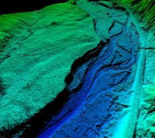
17 Results from Riegl VQ820G in Sandy River, Oregon (2012) Study conducted by Dewberry in collaboration with Watershed Sciences, Inc 21 Powerpoint title goes here December 20, 2011 Digital Seamless Surface topo-bathy Model model
 Ground (GPS) X-section 3 m 6 Distance along transect (m) 1 2 3 4 5 6 2 m Distance along transect (m) 2 3 4 5 22 Powerpoint title goes here December 20,")
18 Elevation (m) Elevation (m) Elevation (m) Elevation (m) 1 Comparing with cross-sections LiDAR cross-sections are 2 m wide. LiDAR vs. GPS vertical accuracy: 18.4 cm RMSE (303 in-stream comparisons) Ground (GPS) X-section 3 m 6 Distance along transect (m) m Distance along transect (m) Powerpoint title goes here December 20, 2011 Distance along transect (m)

 + Project is currently underway (acquisition began Nov 21, 2013).")

19 Supplemental Sandy topobathy LiDAR and imagery task for the NOAA NGS shoreline mapping program + Dewberry tasked as prime contractor under the NOAA CGSC II contract + Teammates Quantum Spatial (LiDAR and Imagery), RC&A (Imagery Acquisition), Woolpert (Imagery Processing) + Project is currently underway (acquisition began Nov 21, 2013). + 3 aircrafts with topobathy LiDAR deployed and 2 aircrafts with DMC (imagery) + Acquisition completed July 27, Flight Missions - ~6,700 flight lines - > 32,000 flightline miles (excluding reflies)


20 Topobathy data preliminary images 6 meters at deepest extent Ocean side bathymetry Dovers Beaches - NJ 6.5 meters at deepest extent


21 Sample profiles Hatteras Island, NC 7 meters at deepest extent 6 meters at deepest extent 11 meters at deepest extent, bathy extending nearly 800 meters offshore

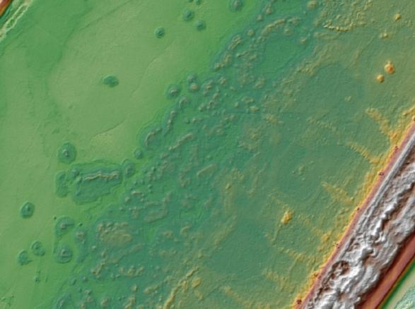
22 Typical Barrier Island System (Assateague Island) 7 cm resolution RGB Imagery Back Bay Tidally influenced wetlands White water Upland Veg. Beach Ocean waves
 Bare Earth Digital Elevation Model")
23 Typical Barrier Island System (Assateague Island) Bare Earth Digital Elevation Model NIR

24 Typical Barrier Island System (Assateague Island) Using NIR water surface data, Green submerged data and Dewberry s custom refraction tool To create seamless topobathy Digital Elevation Model bathymetry bathymetry NOT bathymetry

25 Rich Inlet, Topsail, NC 0.5 m resolution DEM


26 BUILDING FOOTPRINTS FROM LIDAR
27 Building footprints + Automated routines to extract buildings with sparse (1-2 ppsm) data. + May not meet planimetric accuracy standards for low-density LiDAR

28 NEW ASPRS ACCURACY SPECIFICATIONS

29 Purpose + Replaces the existing ASPRS Accuracy Standards for Large-Scale Maps (1990), and the ASPRS Guidelines, Vertical Accuracy Reporting for LiDAR Data (2004) to better address current technologies. + This standard includes positional accuracy standards for - digital orthoimagery, - digital planimetric data and - digital elevation data. + Accuracy classes, based on RMSE values, have been revised and upgraded from the 1990 standard + The standard also includes additional accuracy measures for: - orthoimagery seam lines - aerial triangulation accuracy - LiDAR relative swath-to-swath accuracy, - recommended minimum Nominal Pulse Density (NPD), - horizontal accuracy of elevation data, - delineation of low confidence areas for vertical data, and - the required number and spatial distribution of check points based on project area.

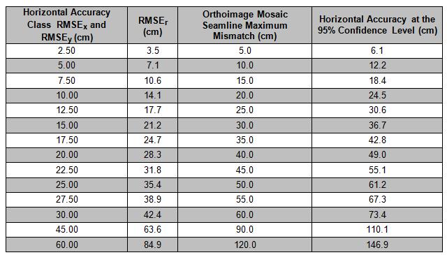
30 Common horizontal accuracy classes
31 Horizontal accuracy interpreted from ASPRS 1990 legacy standard Common Orthoimagery Pixel Sizes Associated Map Scale cm 1: cm 1: cm 1:200 5 cm 1: cm 1: cm 1:1, cm 1:2,400 ASPRS 1990 Accuracy Class Associated Horizontal Accuracy According to Legacy ASPRS 1990 Standard RMSE x and RMSE y RMSE x and RMSE y (cm) in terms of pixels pixels pixels pixels pixels pixels pixels pixels pixels pixels pixels pixels pixels pixels pixels pixels pixels pixels pixels pixels pixels pixels

32 Vertical accuracy / quality examples for digital elevation data
33 Vertical accuracy compared to ASPRS 1990 standard Vertical Accuracy Class RMSE z Non-Vegetated (cm) Equivalent Class 1 contour interval per ASPRS 1990 (cm) Equivalent Class 2 contour interval per ASPRS 1990 (cm) Equivalent contour interval per NMAS (cm) 1-cm cm cm cm cm cm cm cm cm cm
34 3DEP/LiDAR November 2013 National Academy of Public Administration (NAPA) report FEMA Flood Mapping: Enhancing Coordination to Maximize Performance included the following recommendation: + The Office of Management and Budget should use the 3DEP implementation plan for nationwide elevation data collection to guide the development of the President s annual budget request.

35 Summary + Currently available linear-mode LiDAR technology is capable of meeting all requirements of the 3D Elevation Program. + Geiger-mode LiDAR is a new technology that is more efficient for mapping wide areas at much higher densities. - The private industry is developing multiple Geiger mode LiDARs, operational in Seamless topobathy data for floodplain mapping is now feasible with new and improved topobathy systems (in relatively clear coastal and riverine conditions). + Satellite imagery is positioned to acquire very high-resolution imagery at reduced costs. + New ASPRS Accuracy specifications to be published in early 2015 better addresses current and future technologies. + MAPPS urges TMAC to endorse the NAPA recommendation that OMB use 3DEP.

36 Thank you. Questions? Amar Nayegandhi Director of Remote Sensing Dewberry Ph: (office) Cell:
HawkEye III - A new deep penetrating bathymetric LIDAR system
 Please insert a picture (Insert, Picture, from file). Size according to grey field (10 cm x 25.4 cm). Scale picture: highlight, pull corner point Cut picture: highlight, choose the cutting icon from the
Developing Methodology for Efficient Eelgrass Habitat Mapping Across Lidar Systems
 Developing Methodology for Efficient Eelgrass Habitat Mapping Across Lidar Systems VICTORIA PRICE 1, JENNIFER DIJKSTRA 1, JARLATH O NEIL-DUNNE 2, CHRISTOPHER PARRISH 3, ERIN NAGEL 1, SHACHAK PE ERI 1 UNIVERSITY
LIDAR MAPPING FACT SHEET
 1. LIDAR THEORY What is lidar? Lidar is an acronym for light detection and ranging. In the mapping industry, this term is used to describe an airborne laser profiling system that produces location and
Overview. 1. Aerial LiDAR in Wisconsin (20 minutes) 2. Demonstration of data in CAD (30 minutes) 3. High Density LiDAR (20 minutes)
 2. Demonstration of data in CAD (30 minutes) 3. High Density LiDAR (20 minutes)") Overview 1. Aerial LiDAR in Wisconsin (20 minutes) 2. Demonstration of data in CAD (30 minutes) 3. High Density LiDAR (20 minutes) 4. Aerial lidar technology advancements (15 minutes) 5. Q & A 1. Aerial
Overview 1. Aerial LiDAR in Wisconsin (20 minutes) 2. Demonstration of data in CAD (30 minutes) 3. High Density LiDAR (20 minutes) 4. Aerial lidar technology advancements (15 minutes) 5. Q & A 1. Aerial
NOAA Integrated Ocean and Coastal Mapping Using Hurricane Sandy Response Data to Help Build a Bridge Between Lidar Bathymetry and The Chart
 NOAA Integrated Ocean and Coastal Mapping Using Hurricane Sandy Response Data to Help Build a Bridge Between Lidar Bathymetry and The Chart JALBTCX Airborne Coastal Mapping and Charting Workshop July 19-21
An Introduction to Lidar & Forestry May 2013
 An Introduction to Lidar & Forestry May 2013 Introduction to Lidar & Forestry Lidar technology Derivatives from point clouds Applied to forestry Publish & Share Futures Lidar Light Detection And Ranging
RIEGL VQ 880 G Laser Scanner System for Topo Bathymetric Surveying. IR laser scanner channel OCTOBER 2015
 RIEGL VQ 880 G Laser Scanner System for Topo Bathymetric Surveying with NEW optional IR laser scanner channel OCTOBER 2015 VQ 880 G Highlights excellently suited for combined hydrographic and topographic
UAV Surveying II. Precision. Accuracy. Reliability
 UAV Surveying II Precision. Accuracy. Reliability Part One: Project Lifecycle Deliverables Part Two: Evaluation of UAV Data Accuracy and Examples of Error Part Three: AGENDA Review of Results Examples
Light Detection and Ranging (LiDAR)
") Light Detection and Ranging (LiDAR) http://code.google.com/creative/radiohead/ Types of aerial sensors passive active 1 Active sensors for mapping terrain Radar transmits microwaves in pulses determines
Light Detection and Ranging (LiDAR) http://code.google.com/creative/radiohead/ Types of aerial sensors passive active 1 Active sensors for mapping terrain Radar transmits microwaves in pulses determines
Hamilton County Enhances GIS Base Mapping with 1-foot Contours
 Hamilton County Enhances GIS Base Mapping with 1-foot Contours Presented by Larry Stout, Hamilton County GIS Manager Brad Fugate, Woolpert Inc. Today s Presentation Hamilton County s 2004 Base Mapping
Airborne LiDAR Data Acquisition for Forestry Applications. Mischa Hey WSI (Corvallis, OR)
") Airborne LiDAR Data Acquisition for Forestry Applications Mischa Hey WSI (Corvallis, OR) WSI Services Corvallis, OR Airborne Mapping: Light Detection and Ranging (LiDAR) Thermal Infrared Imagery 4-Band
Airborne LiDAR Data Acquisition for Forestry Applications Mischa Hey WSI (Corvallis, OR) WSI Services Corvallis, OR Airborne Mapping: Light Detection and Ranging (LiDAR) Thermal Infrared Imagery 4-Band
A Method to Create a Single Photon LiDAR based Hydro-flattened DEM
 A Method to Create a Single Photon LiDAR based Hydro-flattened DEM Sagar Deshpande 1 and Alper Yilmaz 2 1 Surveying Engineering, Ferris State University 2 Department of Civil, Environmental, and Geodetic
CLASSIFICATION OF NONPHOTOGRAPHIC REMOTE SENSORS
 CLASSIFICATION OF NONPHOTOGRAPHIC REMOTE SENSORS PASSIVE ACTIVE DIGITAL CAMERA THERMAL (e.g. TIMS) VIDEO CAMERA MULTI- SPECTRAL SCANNERS VISIBLE & NIR MICROWAVE HYPERSPECTRAL (e.g. AVIRIS) SLAR Real Aperture
Seabed Mapping with LiDAR
 Seabed Mapping with LiDAR 2011 Jakarta David Jonas Lt Cdr Rupert Forester-Bennett RN (ret( ret d) October 18 th 2011 Mapping in South East Asia Field Survey Aerial Photography LiDAR Pleased to Introduce
Technical Considerations and Best Practices in Imagery and LiDAR Project Procurement
 Technical Considerations and Best Practices in Imagery and LiDAR Project Procurement Presented to the 2014 WV GIS Conference By Brad Arshat, CP, EIT Date: June 4, 2014 Project Accuracy A critical decision
LIDAR an Introduction and Overview
 LIDAR an Introduction and Overview Rooster Rock State Park & Crown Point. Oregon DOGAMI Lidar Project Presented by Keith Marcoe GEOG581, Fall 2007. Portland State University. Light Detection And Ranging
About LIDAR Data. What Are LIDAR Data? How LIDAR Data Are Collected
 1 of 6 10/7/2006 3:24 PM Project Overview Data Description GIS Tutorials Applications Coastal County Maps Data Tools Data Sets & Metadata Other Links About this CD-ROM Partners About LIDAR Data What Are
Better detection and discrimination of seagrasses using fused bathymetric lidar and hyperspectral data
 Better detection and discrimination of seagrasses using fused bathymetric lidar and hyperspectral data Bruce Sabol and Molly Reif US Army Engineer Research and Development Center, Environmental Laboratory
POINT CLOUDS AND DERIVATIVES FOR NATIONWIDE GEOSPATIAL INFORMATION GEORGE VOSSELMAN
 POINT CLOUDS AND DERIVATIVES FOR NATIONWIDE GEOSPATIAL INFORMATION GEORGE VOSSELMAN OVERVIEW Point cloud generation and quality control New lidar technologies Dense matching Updating nationwide point clouds
Aerial and Mobile LiDAR Data Fusion
 Creating Value Delivering Solutions Aerial and Mobile LiDAR Data Fusion Dr. Srini Dharmapuri, CP, PMP What You Will Learn About LiDAR Fusion Mobile and Aerial LiDAR Technology Components & Parameters Project
High resolution survey and orthophoto project of the Dosso-Gaya region in the Republic of Niger. by Tim Leary, Woolpert Inc.
 High resolution survey and orthophoto project of the Dosso-Gaya region in the Republic of Niger by Tim Leary, Woolpert Inc. Geospatial Solutions Photogrammetry & Remote Sensing LiDAR Professional Surveying
LiDAR & Orthophoto Data Report
 LiDAR & Orthophoto Data Report Tofino Flood Plain Mapping Data collected and prepared for: District of Tofino, BC 121 3 rd Street Tofino, BC V0R 2Z0 Eagle Mapping Ltd. #201 2071 Kingsway Ave Port Coquitlam,
3D Elevation Program GeoCue Webinar April 29, The National Map
 + 3D Elevation Program GeoCue Webinar April 29, 2014 The National Map + 3D Elevation Program (3DEP) 2 Topics What is the 3DEP? Overview and background: National Elevation Dataset National Enhanced Elevation
Terrestrial GPS setup Fundamentals of Airborne LiDAR Systems, Collection and Calibration. JAMIE YOUNG Senior Manager LiDAR Solutions
 Terrestrial GPS setup Fundamentals of Airborne LiDAR Systems, Collection and Calibration JAMIE YOUNG Senior Manager LiDAR Solutions Topics Terrestrial GPS reference Planning and Collection Considerations
Alaska Department of Transportation Roads to Resources Project LiDAR & Imagery Quality Assurance Report Juneau Access South Corridor
 Alaska Department of Transportation Roads to Resources Project LiDAR & Imagery Quality Assurance Report Juneau Access South Corridor Written by Rick Guritz Alaska Satellite Facility Nov. 24, 2015 Contents
ALS40 Airborne Laser Scanner
 ALS40 Airborne Laser Scanner Airborne LIDAR for Professionals High Performance Laser Scanning Direct Measurement of Ground Surface from the Air The ALS40 Airborne Laser Scanner measures the topography
A SENSOR FUSION APPROACH TO COASTAL MAPPING
 A SENSOR FUSION APPROACH TO COASTAL MAPPING Maryellen Sault, NOAA, National Ocean Service, National Geodetic Survey Christopher Parrish, NOAA, National Ocean Service, National Geodetic Survey Stephen White,
3D Elevation Program- Status and Updates. Claire DeVaughan South Central Arc User Group Conference April 11, 2018
 + 1 3D Elevation Program- Status and Updates Claire DeVaughan South Central Arc User Group Conference April 11, 2018 + 2 3D Elevation Program (3DEP) Goals Complete acquisition in 8 years Address Federal,
Data Acquisition Through the Geospatial Products and Services Contract (GPSC)
") Data Acquisition Through the Geospatial Products and Services Contract (GPSC) Kathryn Yoder GPSC COTR ESRI, 2015 U.S. Department of the Interior U.S. Geological Survey Overview Background Info Acquisition
Data Acquisition Through the Geospatial Products and Services Contract (GPSC) Kathryn Yoder GPSC COTR ESRI, 2015 U.S. Department of the Interior U.S. Geological Survey Overview Background Info Acquisition
Reality Check: Processing LiDAR Data. A story of data, more data and some more data
 Reality Check: Processing LiDAR Data A story of data, more data and some more data Red River of the North Red River of the North Red River of the North Red River of the North Introduction and Background
Lidar Talking Points Status of lidar collection in Pennsylvania Estimated cost and timeline
 Lidar Talking Points Pennsylvania has an immediate need for new lidar (topographic) data coverage. Some uses of the data are enumerated later in this document. USGS has calculated an average return on
Teanaway Streams Topobathymetric LiDAR
 November 23, 2015 Teanaway Streams Topobathymetric LiDAR Technical Data Report Andrew Norton Puget Sound LiDAR Consortium 1011 Western Avenue, Suite 500 Seattle, WA 98104 PH: 206-971-3283 QSI Corvallis
Lecture 11. LiDAR, RADAR
 NRMT 2270, Photogrammetry/Remote Sensing Lecture 11 Calculating the Number of Photos and Flight Lines in a Photo Project LiDAR, RADAR Tomislav Sapic GIS Technologist Faculty of Natural Resources Management
UAV Flight Operations for Mapping. Precision. Accuracy. Reliability
 UAV Flight Operations for Mapping Precision. Accuracy. Reliability Part One: Why is Mapping different? Part Two: What about accuracy and precision? Part Three: What is the Workflow? Part Four: AGENDA What
Terrestrial Laser Scanning: Applications in Civil Engineering Pauline Miller
 Terrestrial Laser Scanning: Applications in Civil Engineering Pauline Miller School of Civil Engineering & Geosciences Newcastle University Overview Laser scanning overview Research applications geometric
Lidar Technical Report
 Lidar Technical Report Oregon Department of Forestry Sites Presented to: Oregon Department of Forestry 2600 State Street, Building E Salem, OR 97310 Submitted by: 3410 West 11st Ave. Eugene, OR 97402 April
N.J.P.L.S. An Introduction to LiDAR Concepts and Applications
 N.J.P.L.S. An Introduction to LiDAR Concepts and Applications Presentation Outline LIDAR Data Capture Advantages of Lidar Technology Basics Intensity and Multiple Returns Lidar Accuracy Airborne Laser
LiDAR data pre-processing for Ghanaian forests biomass estimation. Arbonaut, REDD+ Unit, Joensuu, Finland
 LiDAR data pre-processing for Ghanaian forests biomass estimation Arbonaut, REDD+ Unit, Joensuu, Finland Airborne Laser Scanning principle Objectives of the research Prepare the laser scanning data for
APPENDIX E2. Vernal Pool Watershed Mapping
 APPENDIX E2 Vernal Pool Watershed Mapping MEMORANDUM To: U.S. Fish and Wildlife Service From: Tyler Friesen, Dudek Subject: SSHCP Vernal Pool Watershed Analysis Using LIDAR Data Date: February 6, 2014
Lidar Sensors, Today & Tomorrow. Christian Sevcik RIEGL Laser Measurement Systems
 Lidar Sensors, Today & Tomorrow Christian Sevcik RIEGL Laser Measurement Systems o o o o Online Waveform technology Stand alone operation no field computer required Remote control through wireless network
Light Detection and Ranging (LiDAR) Radiohead House of Cards
 Radiohead House of Cards") Light Detection and Ranging (LiDAR) Radiohead House of Cards http://the-moni-blog.blogspot.com/2009/03/lidar-is-going-mainstream-mtv-baby.html h =? Laser Vision GPS + IMU θ H X a h Types of aerial sensors
Light Detection and Ranging (LiDAR) Radiohead House of Cards http://the-moni-blog.blogspot.com/2009/03/lidar-is-going-mainstream-mtv-baby.html h =? Laser Vision GPS + IMU θ H X a h Types of aerial sensors
Remote Sensing Sensor Integration
 Remote Sensing Sensor Integration Erica Tharp LiDAR Supervisor Table of Contents About 3001 International Inc Remote Sensing Platforms Why Sensor Integration? Technical Aspects of Sensor Integration Limitations
EXTRACTING SURFACE FEATURES OF THE NUECES RIVER DELTA USING LIDAR POINTS INTRODUCTION
 EXTRACTING SURFACE FEATURES OF THE NUECES RIVER DELTA USING LIDAR POINTS Lihong Su, Post-Doctoral Research Associate James Gibeaut, Associate Research Professor Harte Research Institute for Gulf of Mexico
THE USE OF TERRESTRIAL LASER SCANNING FOR MEASUREMENTS IN SHALLOW-WATER: CORRECTION OF THE 3D COORDINATES OF THE POINT CLOUD
 Photogrammetry and Remote Sensing Published as: Deruyter, G., Vanhaelst, M., Stal, C., Glas, H., De Wulf, A. (2015). The use of terrestrial laser scanning for measurements in shallow-water: correction
Learning Objectives LIGHT DETECTION AND RANGING. Sensing. Blacksburg, VA July 24 th 30 th, 2010 LiDAR: Mapping the world in 3-D Page 1
 LiDAR: Mapping the world in 3-D Val Thomas Department of Forest Resources & Environmental Conservation July 29, 2010 Learning Objectives Part 1: Lidar theory What is lidar? How does lidar work? What are
Orthophotography and LiDAR Terrain Data Collection Rogue River, Oregon Final Report
 Orthophotography and LiDAR Terrain Data Collection Rogue River, Oregon Final Report Prepared by Sky Research, Inc. 445 Dead Indian Memorial Road Ashland, OR 97520 Prepared for Rogue Valley Council of Governments
Workshops funded by the Minnesota Environment and Natural Resources Trust Fund
 Workshops funded by the Minnesota Environment and Natural Resources Trust Fund Conservation Applications of LiDAR Data Workshops funded by: Minnesota Environment and Natural Resources Trust Fund Presented
SLR, Climate Change, Infrastructure Solutions, Adaption and GIS
 Presenters: Francisco D Elia B.S., M.Sc. Geographic Information Systems Franciscodelia@miamibeachfl.gov Nestor Navarro, GISP, MCSA GIS Manager Nestornavarro@miamibeachfl.gov Data Acquisition, Integration
LiDAR Technical Report NE Washington LiDAR Production 2017
 LiDAR Technical Report NE Washington LiDAR Production 2017 Presented to: Washington DNR 1111 Washington Street SE Olympia, Washington 98504 Submitted by: 860 McKinley St Eugene, OR 97402 July 26, 2017
Airborne Laser Scanning: Remote Sensing with LiDAR
 Airborne Laser Scanning: Remote Sensing with LiDAR ALS / LIDAR OUTLINE Laser remote sensing background Basic components of an ALS/LIDAR system Two distinct families of ALS systems Waveform Discrete Return
AIRBORNE GEIGER MODE LIDAR - LATEST ADVANCEMENTS IN REMOTE SENSING APPLICATIONS RANDY RHOADS
 Place image here (10 x 3.5 ) AIRBORNE GEIGER MODE LIDAR - LATEST ADVANCEMENTS IN REMOTE SENSING APPLICATIONS RANDY RHOADS Geospatial Industry Manager HARRIS.COM #HARRISCORP Harris Company Information SECURITY
Quinnipiac Post Flight Aerial Acquisition Report
 Quinnipiac Post Flight Aerial Acquisition Report August 2011 Post-Flight Aerial Acquisition and Calibration Report FEMA REGION 1 Quinnipiac Watershed, Connecticut, Massachusesetts FEDERAL EMERGENCY MANAGEMENT
Municipal Projects in Cambridge Using a LiDAR Dataset. NEURISA Day 2012 Sturbridge, MA
 Municipal Projects in Cambridge Using a LiDAR Dataset NEURISA Day 2012 Sturbridge, MA October 15, 2012 Jeff Amero, GIS Manager, City of Cambridge Presentation Overview Background on the LiDAR dataset Solar
Airborne Laser Survey Systems: Technology and Applications
 Abstract Airborne Laser Survey Systems: Technology and Applications Guangping HE Lambda Tech International, Inc. 2323B Blue Mound RD., Waukesha, WI-53186, USA Email: he@lambdatech.com As mapping products
Victorian Coastline LiDAR Survey 2008 / 2009
 Victorian Coastline LiDAR Survey 2008 / 2009 Airborne LiDAR Bathymetric Survey for Climate Change Victorian Future Coasts Bathymetric LiDAR Survey 2008 / 2009 Mark Sinclair Dr Nathan Quadros Sydney, Australia,
Mayden VP of Business Development Surdex Corporation
 Making Sense of Sensors Randy Mayden, Mayden VP of Business Development Surdex Corporation randym@surdex.com EARLYAERIAL PHOTOGRAPHY 2 FIRSTAERIAL CAMERA 3 AERIAL CAMERA SYSTEM DEVELOPMENT Aerial Camera
Creating a Custom DEM and Measuring Bathymetric Change for the Multnomah Channel & Willamette River Confluence
 Creating a Custom DEM and Measuring Bathymetric Change for the Multnomah Channel & Willamette River Confluence Meara Butler Josh Schane GEOG 593 Fall 2012 Multnomah Channel begins three miles upstream
Wednesday, July 15, Author: Eldris Ferrer Gonzalez, M.Sc. Engineering CSA Group
 Twenty ninth Annual ESRI International User Conference Wednesday, July 15, 2009 Author: Eldris Ferrer Gonzalez, M.Sc. Engineering CSA Group Introduction to Valenciano Project LIDAR Survey for Valenciano
Quality Control Concepts for LiDAR
 Quality Control Concepts for LiDAR January 24, 2012 Engineering Architecture Design-Build Surveying GeoSpatial Solutions Presentation Objectives Offer realistic and constructive advice for LiDAR project
Sandy River, OR Bathymetric Lidar Project, 2012 Delivery QC Analysis Lidar QC Report March 26 th, 2013
 O R E G O N D E P A R T M E N T O F G E O L O G Y A N D M I N E R A L I N D U S T R I E S OLC Sandy River, OR Bathymetric Lidar Project Delivery Acceptance Report. Department of Geology & Mineral Industries
OLC Wasco County: Delivery One.
 OLC Wasco County: Delivery One www.quantumspatial.com January 2, 2014 Trimble R7 Receiver set up over GPS monument WASCO_02. Data collected for: Oregon Department of Geology and Mineral Industries 800
LiDAR data overview. Dr. Keiko Saito Global Facility for Disaster Reduction and Recovery (GFDRR)
") LiDAR data overview Dr. Keiko Saito Global Facility for Disaster Reduction and Recovery (GFDRR) LiDAR (Light Detecting And Ranging) 3D height profile Laser emitted from sensor onboard aircraft to measure
LiDAR data overview Dr. Keiko Saito Global Facility for Disaster Reduction and Recovery (GFDRR) LiDAR (Light Detecting And Ranging) 3D height profile Laser emitted from sensor onboard aircraft to measure
LiDAR Remote Sensing Data Collection: Yaquina and Elk Creek Watershed, Leaf-On Acquisition
 LiDAR Remote Sensing Data Collection: Yaquina and Elk Creek Watershed, Leaf-On Acquisition Submitted by: 4605 NE Fremont, Suite 211 Portland, Oregon 97213 April, 2006 Table of Contents LIGHT DETECTION
The Use of UAV s for Gathering Spatial Information. James Van Rens CEO MAPPS Winter Conference January, 2015
 The Use of UAV s for Gathering Spatial Information James Van Rens CEO MAPPS Winter Conference January, 2015 1 UAV Technological Timeline 1980 s RPV (Remotely Piloted Vehicle) Operator on ground, almost
Cooperating Technical Partners Information Exchange. LIDAR QA/QC and Extracting Building Footprints
 Cooperating Technical Partners Information Exchange LIDAR QA/QC and Extracting Building Footprints Audio and Web Settings Participation Open and hide your control panel using the orange arrow button at
Existing Elevation Data Sets. Quality Level 2 (QL2) Lidar Data Sets. Better Land Characterization More Accurate Results!
 Lidar Data Sets. Better Land Characterization More Accurate Results!") Existing Elevation Data Sets Out of Date: Most > 40 yrs old Data range from 15 yrs old to > 70 yrs old Spatial Resolution: 33 ft (10 m) or coarser Vertical Accuracy: 3.3 ft 6.6 ft (1 2 m) or worse Quality
Existing Elevation Data Sets Out of Date: Most > 40 yrs old Data range from 15 yrs old to > 70 yrs old Spatial Resolution: 33 ft (10 m) or coarser Vertical Accuracy: 3.3 ft 6.6 ft (1 2 m) or worse Quality
SPAR, ELMF 2013, Amsterdam. Laser Scanning on the UK Highways Agency Network. Hamish Grierson Blom Uk
 SPAR, ELMF 2013, Amsterdam Laser Scanning on the UK Highways Agency Network Hamish Grierson Blom Uk www.blomasa.com www.blom-uk.co.uk Blom UK Part of the Blom Group Blom Group - Europe s largest aerial
Wetlands Mapping Consortium 4/18/2012
 USGS LiDAR Guidelines and Base Specification V.13 Wetlands Mapping Consortium 4/18/2012 David F. Maune, Ph.D., CP Dewberry dmaune@dewberry.com Substituting for Karl Heidemann of USGS, primary author of
LiDAR Remote Sensing Data Collection: Salmon River Study Area, Oregon
 LiDAR Remote Sensing Data Collection: Salmon River Study Area, Oregon Submitted to: Barbara Ellis-Sugai USDA Forest Service Siuslaw National Forest 4077 SW Research Way Corvallis, Oregon 541.750.7056 Submitted
James Van Rens CEO Riegl USA, Inc. Mining Industry and UAV s combined with LIDAR Commercial UAV Las Vegas October 2015 James Van Rens CEO Riegl USA
 James Van Rens CEO Riegl USA, Inc. Mining Industry and UAV s combined with LIDAR Commercial UAV Las Vegas October 2015 James Van Rens CEO Riegl USA COST EFFECIENCY CONTINUUM LIDAR and IMU Partnership Technology
Absolute Horizontal Accuracies of Pictometry s Individual Orthogonal Frame Imagery
 A Pictometry International, Corp White Paper Absolute Horizontal Accuracies of Pictometry s Individual Orthogonal Frame Imagery Michael J. Zoltek VP, Surveying & Mapping Pictometry International, Corp
Windstorm Simulation & Modeling Project
 Windstorm Simulation & Modeling Project Airborne LIDAR Data and Digital Elevation Models in Broward County, Florida Data Quality Report and Description of Deliverable Datasets Prepared for: The Broward
UTILIZACIÓN DE DATOS LIDAR Y SU INTEGRACIÓN CON SISTEMAS DE INFORMACIÓN GEOGRÁFICA
 UTILIZACIÓN DE DATOS LIDAR Y SU INTEGRACIÓN CON SISTEMAS DE INFORMACIÓN GEOGRÁFICA Aurelio Castro Cesar Piovanetti Geographic Mapping Technologies Corp. (GMT) Consultores en GIS info@gmtgis.com Geographic
UAS based laser scanning for forest inventory and precision farming
 UAS based laser scanning for forest inventory and precision farming M. Pfennigbauer, U. Riegl, P. Rieger, P. Amon RIEGL Laser Measurement Systems GmbH, 3580 Horn, Austria Email: mpfennigbauer@riegl.com,
MISSISSIPPI AND ALABAMA COASTAL MAPPING
 LIDAR REPORT MISSISSIPPI AND ALABAMA COASTAL MAPPING U.S. ARMY CORPS OF ENGINEERS MOBILE DISTRICT CONTRACTOR: R&M CONSULTANTS, INC. CONTRACT NO. W91278-04-D-0001/0003 EN PROJECT NO. C-05-054 Prepared By:
Introduction to Remote Sensing
 Introduction to Remote Sensing Spatial, spectral, temporal resolutions Image display alternatives Vegetation Indices Image classifications Image change detections Accuracy assessment Satellites & Air-Photos
2010 LiDAR Project. GIS User Group Meeting June 30, 2010
 2010 LiDAR Project GIS User Group Meeting June 30, 2010 LiDAR = Light Detection and Ranging Technology that utilizes lasers to determine the distance to an object or surface Measures the time delay between
CLOSING REMARKS. Dr. Qassim Abdullah, Woolpert, Inc. ASPRS Positional Accuracy Standards
 CLOSING REMARKS Dr. Qassim Abdullah, Woolpert, Inc. ASPRS Positional Accuracy Standards Understanding the New ASPRS Positional Accuracy Standards for Digital Geospatial Data and its Applicability to UAS-based
Eunmi Chang, Hyo-Hyun Sung, Jaeyeong Roh, Eunyoung Kim
 Eunmi Chang, Hyo-Hyun Sung, Jaeyeong Roh, Eunyoung Kim Ziinconsulting INC., Ewha Woman s University Korean Hydrographic and Oceanographic Administration Geostrory INC. Based on (IMO Res. A 884(21)) Marine
2017 OLC Silver Creek
 2017 OLC Silver Creek December 15, 2017 www.quantumspatial.com Data collected for: Oregon Department of Geology and Mineral Industries 800 NE Oregon Street Suite 965 Portland, OR 97232 Prepared by: Quantum
HYDROFEST 2005 CAPABILITIES OF A MODERN BATHYMETRIC LIDAR SYSTEM - THE SHOALS 1000T SYSTEM. Bill Gilmour Fugro Pelagos Inc, San Diego, CA, USA
 HYDROFEST 2005 CAPABILITIES OF A MODERN BATHYMETRIC LIDAR SYSTEM - THE SHOALS 1000T SYSTEM Bill Gilmour Fugro Pelagos Inc, San Diego, CA, USA ACKNOWLEDGEMENTS FUGRO PELAGOS INC. David Millar Carol Lockhart
Trends in Digital Aerial Acquisition Systems
 Trends in Digital Aerial Acquisition Systems Ernest Yap Regional Sales Manager, Airborne-Americas eyap@applanix.com 1 Medium Format Digital Cameras Medium Format Digital Cameras Where does the Medium
Leica ALS70. Airborne Laser Scanners Performance for diverse Applications
 Leica ALS70 Airborne Laser Scanners Performance for diverse Applications Three Models, One Result. Highest Productivity in all Applications. Imagine an affordable 500 khz pulse rate city-mapping LIDAR
UAS Campus Survey Project
 ARTICLE STUDENTS CAPTURING SPATIAL INFORMATION NEEDS UAS Campus Survey Project Texas A&M University- Corpus Christi, home to the largest geomatics undergraduate programme in Texas, USA, is currently undergoing
LiDAR for Urban Change Detection. Keith W. Cunningham, PhD Alaska Satellite Facility November 13, 2009
 LiDAR for Urban Change Detection Keith W. Cunningham, PhD Alaska Satellite Facility November 13, 2009 LiDAR LiDAR Light Detection and Ranging Building Footprints GIS outlines (planimetrics) GIS Geographic
Leica - Airborne Digital Sensors (ADS80, ALS60) Update / News in the context of Remote Sensing applications
 Update / News in the context of Remote Sensing applications") Luzern, Switzerland, acquired with GSD=5 cm, 2008. Leica - Airborne Digital Sensors (ADS80, ALS60) Update / News in the context of Remote Sensing applications Arthur Rohrbach, Sensor Sales Dir Europe,
Luzern, Switzerland, acquired with GSD=5 cm, 2008. Leica - Airborne Digital Sensors (ADS80, ALS60) Update / News in the context of Remote Sensing applications Arthur Rohrbach, Sensor Sales Dir Europe,
JALBTCX Activities and USACE National Coastal Mapping Program Update
 JALBTCX Activities and USACE National Coastal Mapping Program Update Jennifer M. Wozencraft Director, Joint Airborne Lidar Bathymetry Technical Center of Expertise Manager, National Coastal Mapping Program
Airborne discrete return LiDAR data was collected on September 3-4, 2007 by
 SUPPLEMENTAL MATERIAL 2 LiDAR Specifications Airborne discrete return LiDAR data was collected on September 3-4, 2007 by Watershed Sciences, Inc. (Corvallis, Oregon USA). LiDAR was collected approximately
TAKING FLIGHT JULY/AUGUST 2015 COMMERCIAL UAS ADVANCEMENT BALLOONS THE POOR MAN S UAV? SINGLE PHOTON SENSOR REVIEW VOLUME 5 ISSUE 5
 VOLUME 5 ISSUE 5 JULY/AUGUST 2015 TAKING FLIGHT 14 COMMERCIAL UAS ADVANCEMENT 24 BALLOONS THE POOR MAN S UAV? 30 SINGLE PHOTON SENSOR REVIEW Closing in on 500 authorizations the FAA has expedited the exemption
U.S. Geological Survey (USGS) - National Geospatial Program (NGP) and the American Society for Photogrammetry and Remote Sensing (ASPRS)
 - National Geospatial Program (NGP) and the American Society for Photogrammetry and Remote Sensing (ASPRS)") U.S. Geological Survey (USGS) - National Geospatial Program (NGP) and the American Society for Photogrammetry and Remote Sensing (ASPRS) Summary of Research and Development Efforts Necessary for Assuring
U.S. Geological Survey (USGS) - National Geospatial Program (NGP) and the American Society for Photogrammetry and Remote Sensing (ASPRS) Summary of Research and Development Efforts Necessary for Assuring
The Reference Library Generating Low Confidence Polygons
 GeoCue Support Team In the new ASPRS Positional Accuracy Standards for Digital Geospatial Data, low confidence areas within LIDAR data are defined to be where the bare earth model might not meet the overall
Terrain categorization using LIDAR and multi-spectral data
 Terrain categorization using LIDAR and multi-spectral data Angela M. Puetz, R. C. Olsen, Michael A. Helt U.S. Naval Postgraduate School, 833 Dyer Road, Monterey, CA 93943 ampuetz@nps.edu, olsen@nps.edu
LiDAR Derived Contours
 LiDAR Derived Contours Final Delivery June 10, 2009 Prepared for: Prepared by: Metro 600 NE Grand Avenue Portland, OR 97232 Watershed Sciences, Inc. 529 SW Third Avenue, Suite 300 Portland, OR 97204 Metro
Should Contours Be Generated from Lidar Data, and Are Breaklines Required? Lidar data provides the most
 Should Contours Be Generated from Lidar Data, and Are Breaklines Required? Lidar data provides the most accurate and reliable representation of the topography of the earth. As lidar technology advances
Contents of Lecture. Surface (Terrain) Data Models. Terrain Surface Representation. Sampling in Surface Model DEM
 Data Models. Terrain Surface Representation. Sampling in Surface Model DEM") Lecture 13: Advanced Data Models: Terrain mapping and Analysis Contents of Lecture Surface Data Models DEM GRID Model TIN Model Visibility Analysis Geography 373 Spring, 2006 Changjoo Kim 11/29/2006 1
Lecture 13: Advanced Data Models: Terrain mapping and Analysis Contents of Lecture Surface Data Models DEM GRID Model TIN Model Visibility Analysis Geography 373 Spring, 2006 Changjoo Kim 11/29/2006 1
Development of Unmanned Aircraft System (UAS) for Agricultural Applications. Quarterly Progress Report
 for Agricultural Applications. Quarterly Progress Report") Development of Unmanned Aircraft System (UAS) for Agricultural Applications Quarterly Progress Report Reporting Period: October December 2016 January 30, 2017 Prepared by: Lynn Fenstermaker and Jayson
Development of Unmanned Aircraft System (UAS) for Agricultural Applications Quarterly Progress Report Reporting Period: October December 2016 January 30, 2017 Prepared by: Lynn Fenstermaker and Jayson
LiDAR Engineering and Design Applications. Sample Data
 LiDAR Engineering and Design Applications Sample Data High density LiDAR will return points on any visible part of a structure. Modeling of Existing Structures 2 The distance between any two positions
Stitching Fine Resolution DEMs
 18 th World IMACS / MODSIM Congress, Cairns, Australia 13-17 July 2009 http://mssanz.org.au/modsim09 Stitching Fine Resolution DEMs Gallant, J.C. 1 and J.M. Austin 1 1 CSIRO Land and Water, Black Mountain
The Applanix Approach to GPS/INS Integration
 Lithopoulos 53 The Applanix Approach to GPS/INS Integration ERIK LITHOPOULOS, Markham ABSTRACT The Position and Orientation System for Direct Georeferencing (POS/DG) is an off-the-shelf integrated GPS/inertial
NATIONWIDE POINT CLOUDS AND 3D GEO- INFORMATION: CREATION AND MAINTENANCE GEORGE VOSSELMAN
 NATIONWIDE POINT CLOUDS AND 3D GEO- INFORMATION: CREATION AND MAINTENANCE GEORGE VOSSELMAN OVERVIEW National point clouds Airborne laser scanning in the Netherlands Quality control Developments in lidar