SLR, Climate Change, Infrastructure Solutions, Adaption and GIS
|
|
|
- Claribel Cooper
- 5 years ago
- Views:
Transcription
1 Presenters: Francisco D Elia B.S., M.Sc. Geographic Information Systems Franciscodelia@miamibeachfl.gov Nestor Navarro, GISP, MCSA GIS Manager Nestornavarro@miamibeachfl.gov


2 Data Acquisition, Integration and Impact Modeling Geographic Information Systems and Survey Engineering Emergency Response Environment and Sustainability Urban Planning Aerial LIDAR Topographic LIDAR Aerial Survey and Positioning Bathymetric Survey Sonar GPS Tracer / Flow Meter
3
4
5 Aerial LIDAR Data 1- Existing data allows the extraction of ground elevations, buildings and other features
6 Aerial LIDAR 1- LIDAR QA QC vs Re-Classification 2015 / LP360 HARRIS - ESRI 3- Validation Accuracy Test - City Benchmarks 4- Feature Extraction Object Oriented Algorithms 5-Integration - 6-Products


7 SLR, Climate Change, Infrastructure Solutions, Adaption and GIS

8
9

10
11
12


13 Mobile LIDAR Survey 1- Urban environment: Roads, buildings, ROW 3D modeling and feature extraction. Mobile LIDAR unit mounted on SUV for urban infrastructure 3D mapping

14 Topographic LIDAR survey grade feature extraction capabilities

15

16 Bathymetric and Seawall LIDAR Survey Seawall Survey Focus on sea wall from horizontal and vertical perspectives. Mobile LIDAR unit mounted on boat for coastal infrastructure 3D mapping.

17 Bathymetric and Seawall LIDAR Survey Seawall Survey Focus on sea wall from horizontal and vertical perspectives. Collins Canal Bay Road end, 3D Point Cloud capturing seawall conditions and height


18 Geological Survey of Miami Beach AECOM and USGS 42 Monitoring Wells Characterize Lithology Identify Confining Geological Unit Confining unit found at the Keys starting at 250 f. So far in Miami Beach no confining unit were found at 330 f. Future drilling will go to 400.


19 Geological Survey of Miami Beach AECOM and USGS 42 Monitoring Wells Characterize Lithology Identify Confining Geological Unit Confining unit found at the Keys starting at 250 f. So far in Miami Beach no confining unit were found at 330 f. Future drilling will go to 400.

20 Storm Surge Modelling Existing models are too course to represent the effects of storm surge in Miami Beach A high resolution storm surge model could also assist on validating infrastructure changes and future adaptation strategies.
: Position, temperature and")

21 Circulation Patters (Direction, Velocity and Temperature) - GPS Tracker Dynamic (Drifter): Position, temperature and time. - Flow Meter Stationary: Current, direction, pressure, temperature, conductivity and turbidity GPS Tracker Flow Meter
 1- Circulation patterns 3- Chlorophyll Increase")

22 Water Quality and Circulation Patters (Direction, Velocity and Temperature) 1- Circulation patterns 3- Chlorophyll Increase 2- Seagrass Loss 4- Storm Water Diffusion Discharge origin, GPS tracer launching location Dispersion pattern and tracer tracking


23 Circulation Patters (Direction and Velocity) - GPS Tracker Dynamic (Drifter): Position, temperature and time. - Flow Meter Stationary sensor: Current, direction, pressure, temperature, conductivity and turbidity Midas ECM Electromagnetic Current Meter Lagrangian Tracer Drifter tracks and HF Radar current readings plotted on top of remotely sensed Sea Surface Temperature (SST).


24 Unmanned Aircraft System and Hydro Drone Survey UX5 UX5 HP SONAR GPS Tracer MikaSense Red Edge Multispectral Sensor SONY ar7


25 Algae Concentration Remote Sensing Survey: Chlorophyll concentration and potential harmful bacteria concentrations. 5 Band Multispectral Sensor Seamless mosaic e.g. Cyanobacteria in the Baltic Sea

26 Resiliency Data Management Framework Overview Resiliency Data Management Framework Data Acquisition, Integration and SLR Impact Modeling Geographic Information Systems Engineering Emergency Response Environment and Sustainability Urban Planning Aerial LIDAR Topographic LIDAR Aerial Survey Photogrammetry and Remote Sensing. Bathymetric Survey Sonar Dynamic Storm Surge and SLR Modelling Hydrologic studies Synthetic modelling solution validation Ground water modeling Post event assessment SLR risk assessment ZIKA prevention Green infrastructure Water circulation Beach, reef and coastal vegetation monitoring Water quality monitoring Historical districts vulnerability assessment Historical buildings scanning As Builds Water quality studies GPS Tracer / Flow Meter Wind circulation study


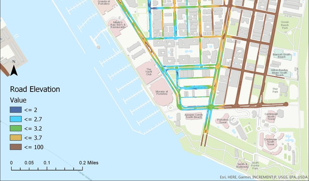
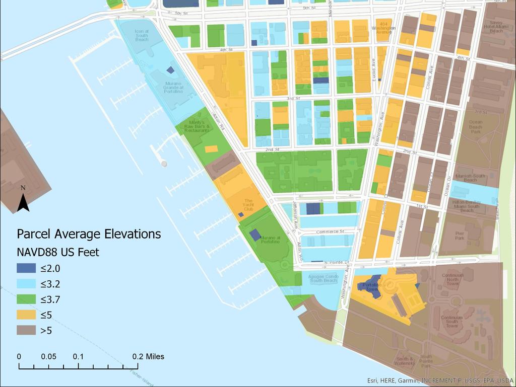
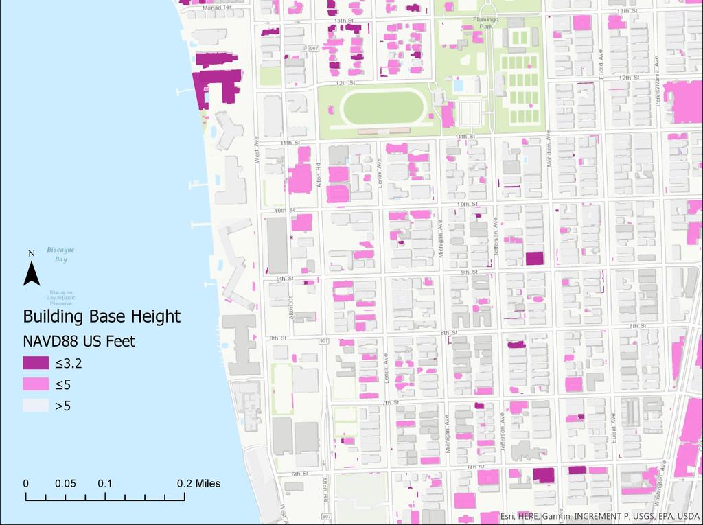
27 Data Acquisition, Integration and SLR Impact Modeling Component 1 Aerial Survey, Positioning an Sonar Integration Bathymetric Survey - Hydro Drone Mapping of sea floor depth, sonar and GPS integration. HyDrone equipped with sonar and GPS units SonarMite Receiver e.g. E-W profile of canal depth
28 Data Acquisition, Integration and SLR Impact Modeling Component 1 Aerial Survey, Positioning an Sonar Integration Water Way Characterization: The main focus is to be able to determine the presence of bacteria at discharge points into the Bay (i.e., outfalls) and track advection, diffusion, and dispersion patterns through circulation analyses. A- Current Circulation Patters GPS Tracer B- Bathymetric Survey - Sonar C- Turbidity Mapping Aerial Photography D- Algae Concentration Mapping Remote Sensing

29 Data Acquisition, Integration and SLR Impact Modeling Component 1 Aerial Survey, Positioning an Sonar Integration Turbidity Mapping - Aerial Photography Survey: Fully automated flight plan tools, safe and precise. 36MP ½ inc Spatial Res. Seamless mosaic Automated flight control with high safety standards


30 Data Acquisition, Integration and SLR Impact Modeling Component 1 Aerial Survey, Positioning an Sonar Integration Turbidity Mapping - Aerial Photography: Diffusion and dispersion patters. Outfall discharge or dye release Dispersion patters
31 Data Acquisition, Integration and SLR Impact Modeling Component 1 Aerial Survey, Positioning an Sonar Integration Water Way Characterization The main focus is to be able to determine the presence of bacteria at discharge points into the Bay (i.e., outfalls) and track advection, diffusion, and dispersion patterns through circulation analyses. A- Current Circulation Patters GPS Tracer B- Bathymetric Survey - Sonar C- Turbidity Mapping Aerial Photography D- Algae Concentration Mapping Remote Sensing


32 Data Acquisition, Integration and SLR Impact Modeling Component 1 Aerial Survey and Positioning Algae Concentration Remote Sensing Approach: Chlorophyll concentration and potential harmful bacteria concentrations.
33 Data Acquisition, Integration and SLR Impact Modeling Component 1 Aerial Survey and Positioning UAS applications to the City of Miami Beach The proposed Aerial Survey equipment can assist the City of Miami Beach on the following fields, saving time and resources on data collection. - Water Way Characterization * - Vegetation health index (NDVI) - Beach erosion monitoring - Zika prevention - Post hurricane damage assessment - Digital terrain model generation - Aerial photography
34 Data Acquisition, Integration and SLR Impact Modeling Components 1 and 2 Component 1 Aerial Survey and Positioning GPS tracking Water Circulation Patters Sonar survey Sea Floor Depth Photogrammetry - Aerial Photography Remote Sensing - Electromagnetic Radiation Component 2 Topographic Mobile LIDAR Mobile LIDAR (Light Detection and Ranging) City Buildings, Sea Walls and ROW.


35 Data Acquisition, Integration and SLR Impact Modeling Aerial LIDAR Data 1- Existing data allows the extraction of ground elevations, buildings and other features Aerial LIDAR survey provided by MDC 2008, 2015 and possibly 2017.

36 Data Acquisition, Integration and SLR Impact Modeling Component 1 Topographic Mobile LIDAR Unit Flood Risk Modeling at the Property Level Topography LIDAR data will allow Vulnerability Assessment for Flooding at the property level. Existing data for buildings minimum height extracted from aerial LIDAR survey done by MDC in 05/2015.

37 Data Acquisition, Integration and SLR Impact Modeling Component 1 Topographic Mobile LIDAR Unit
38 THANK YOU QUESTIONS?
N.J.P.L.S. An Introduction to LiDAR Concepts and Applications
 N.J.P.L.S. An Introduction to LiDAR Concepts and Applications Presentation Outline LIDAR Data Capture Advantages of Lidar Technology Basics Intensity and Multiple Returns Lidar Accuracy Airborne Laser
Overview. 1. Aerial LiDAR in Wisconsin (20 minutes) 2. Demonstration of data in CAD (30 minutes) 3. High Density LiDAR (20 minutes)
 2. Demonstration of data in CAD (30 minutes) 3. High Density LiDAR (20 minutes)") Overview 1. Aerial LiDAR in Wisconsin (20 minutes) 2. Demonstration of data in CAD (30 minutes) 3. High Density LiDAR (20 minutes) 4. Aerial lidar technology advancements (15 minutes) 5. Q & A 1. Aerial
Overview 1. Aerial LiDAR in Wisconsin (20 minutes) 2. Demonstration of data in CAD (30 minutes) 3. High Density LiDAR (20 minutes) 4. Aerial lidar technology advancements (15 minutes) 5. Q & A 1. Aerial
LORI COLLINS, RESEARCH ASSOCIATE PROFESSOR CONTRIBUTIONS BY: RICHARD MCKENZIE AND GARRETT SPEED, DHHC USF L IBRARIES
 LORI COLLINS, RESEARCH ASSOCIATE PROFESSOR CONTRIBUTIONS BY: RICHARD MCKENZIE AND GARRETT SPEED, DHHC USF L IBRARIES AERIAL AND TERRESTRIAL SURVEY WORKFLOWS Workflow from project planning applications
Hamilton County Enhances GIS Base Mapping with 1-foot Contours
 Hamilton County Enhances GIS Base Mapping with 1-foot Contours Presented by Larry Stout, Hamilton County GIS Manager Brad Fugate, Woolpert Inc. Today s Presentation Hamilton County s 2004 Base Mapping
Contents of Lecture. Surface (Terrain) Data Models. Terrain Surface Representation. Sampling in Surface Model DEM
 Data Models. Terrain Surface Representation. Sampling in Surface Model DEM") Lecture 13: Advanced Data Models: Terrain mapping and Analysis Contents of Lecture Surface Data Models DEM GRID Model TIN Model Visibility Analysis Geography 373 Spring, 2006 Changjoo Kim 11/29/2006 1
Lecture 13: Advanced Data Models: Terrain mapping and Analysis Contents of Lecture Surface Data Models DEM GRID Model TIN Model Visibility Analysis Geography 373 Spring, 2006 Changjoo Kim 11/29/2006 1
CLASSIFICATION OF NONPHOTOGRAPHIC REMOTE SENSORS
 CLASSIFICATION OF NONPHOTOGRAPHIC REMOTE SENSORS PASSIVE ACTIVE DIGITAL CAMERA THERMAL (e.g. TIMS) VIDEO CAMERA MULTI- SPECTRAL SCANNERS VISIBLE & NIR MICROWAVE HYPERSPECTRAL (e.g. AVIRIS) SLAR Real Aperture
UAS Campus Survey Project
 ARTICLE STUDENTS CAPTURING SPATIAL INFORMATION NEEDS UAS Campus Survey Project Texas A&M University- Corpus Christi, home to the largest geomatics undergraduate programme in Texas, USA, is currently undergoing
An Introduction to Lidar & Forestry May 2013
 An Introduction to Lidar & Forestry May 2013 Introduction to Lidar & Forestry Lidar technology Derivatives from point clouds Applied to forestry Publish & Share Futures Lidar Light Detection And Ranging
UAV Surveying II. Precision. Accuracy. Reliability
 UAV Surveying II Precision. Accuracy. Reliability Part One: Project Lifecycle Deliverables Part Two: Evaluation of UAV Data Accuracy and Examples of Error Part Three: AGENDA Review of Results Examples
UAS to GIS Utilizing a low-cost Unmanned Aerial System (UAS) for Coastal Erosion Monitoring
 for Coastal Erosion Monitoring") UAS to GIS Utilizing a low-cost Unmanned Aerial System (UAS) for Coastal Erosion Monitoring A New Window on the World Personal Mapping for Micro-Geographies Accurate High Quality Simple Low-Cost Drone2Map
UAS to GIS Utilizing a low-cost Unmanned Aerial System (UAS) for Coastal Erosion Monitoring A New Window on the World Personal Mapping for Micro-Geographies Accurate High Quality Simple Low-Cost Drone2Map
2/9/2016. Session Agenda: Implementing new Geospatial Technologies for more efficient data capture
 Implementing new Geospatial Technologies for more efficient data capture Jay Haskamp Applied Geospatial Engineer Steve Richter VP Sales Session Agenda: Today s changing technologies and what lies ahead
Case Study for Long- Range Beyond Visual Line of Sight Project. March 15, 2018 RMEL Transmission and Planning Conference
 Case Study for Long- Range Beyond Visual Line of Sight Project March 15, 2018 RMEL Transmission and Planning Conference 2014 HDR Architecture, 2016 2014 HDR, Inc., all all rights reserved. Helicopters
LIDAR and Terrain Models: In 3D!
 LIDAR and Terrain Models: In 3D! Stuart.green@teagasc.ie http://www.esri.com/library/whitepapers/pdfs/lidar-analysis-forestry.pdf http://www.csc.noaa.gov/digitalcoast/_/pdf/refinement_of_topographic_lidar_to_create_a_bare_e
Automated Feature Extraction from Aerial Imagery for Forestry Projects
 Automated Feature Extraction from Aerial Imagery for Forestry Projects Esri UC 2015 UC706 Tuesday July 21 Bart Matthews - Photogrammetrist US Forest Service Southwestern Region Brad Weigle Sr. Program
2-4 April 2019 Taets Art and Event Park, Amsterdam CLICK TO KNOW MORE
 Co-Host Host 2-4 April 2019 Taets Art and Event Park, Amsterdam CLICK TO KNOW MORE Presentation Outline review modern survey methodologies available to support railway requirements measuring everything
About LIDAR Data. What Are LIDAR Data? How LIDAR Data Are Collected
 1 of 6 10/7/2006 3:24 PM Project Overview Data Description GIS Tutorials Applications Coastal County Maps Data Tools Data Sets & Metadata Other Links About this CD-ROM Partners About LIDAR Data What Are
Seabed Mapping with LiDAR
 Seabed Mapping with LiDAR 2011 Jakarta David Jonas Lt Cdr Rupert Forester-Bennett RN (ret( ret d) October 18 th 2011 Mapping in South East Asia Field Survey Aerial Photography LiDAR Pleased to Introduce
TAKING FLIGHT JULY/AUGUST 2015 COMMERCIAL UAS ADVANCEMENT BALLOONS THE POOR MAN S UAV? SINGLE PHOTON SENSOR REVIEW VOLUME 5 ISSUE 5
 VOLUME 5 ISSUE 5 JULY/AUGUST 2015 TAKING FLIGHT 14 COMMERCIAL UAS ADVANCEMENT 24 BALLOONS THE POOR MAN S UAV? 30 SINGLE PHOTON SENSOR REVIEW Closing in on 500 authorizations the FAA has expedited the exemption
INTRODUCTION TO Accelerating Data Collection with Unmanned Aircraft Systems
 INTRODUCTION TO Accelerating Data Collection with Unmanned Aircraft Systems Kyle Kukuk Terry Pallotto MWCC Enviromental Conference July 10-12, 2016 Who is Here? Kyle Kukuk, PE Project Manager Blackstone
LiDAR data overview. Dr. Keiko Saito Global Facility for Disaster Reduction and Recovery (GFDRR)
") LiDAR data overview Dr. Keiko Saito Global Facility for Disaster Reduction and Recovery (GFDRR) LiDAR (Light Detecting And Ranging) 3D height profile Laser emitted from sensor onboard aircraft to measure
LiDAR data overview Dr. Keiko Saito Global Facility for Disaster Reduction and Recovery (GFDRR) LiDAR (Light Detecting And Ranging) 3D height profile Laser emitted from sensor onboard aircraft to measure
REMOTE SENSING LiDAR & PHOTOGRAMMETRY 19 May 2017
 REMOTE SENSING LiDAR & PHOTOGRAMMETRY 19 May 2017 SERVICES Visual Inspections Digital Terrain Models Aerial Imagery Volume Computations Thermal Inspections Photo maps Aerial Video Training & Consultancy
High resolution survey and orthophoto project of the Dosso-Gaya region in the Republic of Niger. by Tim Leary, Woolpert Inc.
 High resolution survey and orthophoto project of the Dosso-Gaya region in the Republic of Niger by Tim Leary, Woolpert Inc. Geospatial Solutions Photogrammetry & Remote Sensing LiDAR Professional Surveying
Remote sensing techniques applied to seismic vulnerability assessment
 Remote sensing techniques applied to seismic vulnerability assessment JJ Arranz (josejuan.arranz@upm.es), Y. Torres (y.torres@upm.es), A. Haghi (a.haghi@alumnus.upm.es), J. Gaspar (jorge.gaspar@upm.es)
Todd King, PLS, LEED AP Business Developer
 Todd King, PLS, LEED AP Business Developer TKing@McKimCreed.com 38 YEARS 378 EMPLOYEES ENR Top 500 Design Firm ENR Top 200 Environmental ENR Southeast Engineer Firms POB Geospatial Top 100 Top 50 Trenchless
LIDAR MAPPING FACT SHEET
 1. LIDAR THEORY What is lidar? Lidar is an acronym for light detection and ranging. In the mapping industry, this term is used to describe an airborne laser profiling system that produces location and
9/14/2011. Contents. Lecture 3: Spatial Data Acquisition in GIS. Dr. Bo Wu Learning Outcomes. Data Input Stream in GIS
 Contents Lecture 3: Spatial Data Acquisition in GIS Dr. Bo Wu lsbowu@polyu.edu.hk 1. Learning outcomes. Data acquisition: Manual digitization 3. Data acquisition: Field survey 4. Data acquisition: Remote
A SENSOR FUSION APPROACH TO COASTAL MAPPING
 A SENSOR FUSION APPROACH TO COASTAL MAPPING Maryellen Sault, NOAA, National Ocean Service, National Geodetic Survey Christopher Parrish, NOAA, National Ocean Service, National Geodetic Survey Stephen White,
Aerial and Mobile LiDAR Data Fusion
 Creating Value Delivering Solutions Aerial and Mobile LiDAR Data Fusion Dr. Srini Dharmapuri, CP, PMP What You Will Learn About LiDAR Fusion Mobile and Aerial LiDAR Technology Components & Parameters Project
Alaska Department of Transportation Roads to Resources Project LiDAR & Imagery Quality Assurance Report Juneau Access South Corridor
 Alaska Department of Transportation Roads to Resources Project LiDAR & Imagery Quality Assurance Report Juneau Access South Corridor Written by Rick Guritz Alaska Satellite Facility Nov. 24, 2015 Contents
Harnessing GIS and Imagery for Power Transmission Inspection. ESRI European Users Conference October 15, 2015
 Harnessing GIS and Imagery for Power Transmission Inspection ESRI European Users Conference October 15, 2015 About Us Airborne/Threod Designer, manufacturer & service provider for multi-rotor & fixed wing
Technical Considerations and Best Practices in Imagery and LiDAR Project Procurement
 Technical Considerations and Best Practices in Imagery and LiDAR Project Procurement Presented to the 2014 WV GIS Conference By Brad Arshat, CP, EIT Date: June 4, 2014 Project Accuracy A critical decision
UAS for Surveyors. An emerging technology for the Geospatial Industry. Ian Murgatroyd : Technical Sales Rep. Trimble
 UAS for Surveyors An emerging technology for the Geospatial Industry Ian Murgatroyd : Technical Sales Rep. Trimble Project Overview Voyager Quarry, located near Perth Australia Typical of hard rock mines,
Exercise 1: Introduction to ILWIS with the Riskcity dataset
 Exercise 1: Introduction to ILWIS with the Riskcity dataset Expected time: 2.5 hour Data: data from subdirectory: CENN_DVD\ILWIS_ExerciseData\IntroRiskCity Objectives: After this exercise you will be able
Quality Accuracy Professionalism
 GeoWing - who are we? Mapping Data Service Provider Lidar Multispectral Topographic and Planimetric Maps Elevation Models Point Clouds / 3D Models Orthophotography FAA-Authorized UAS Operators WOSB / DBE
Data Acquisition; Maintenance, and Dissemination
 Data Acquisition; Maintenance, and Dissemination Amar Nayegandhi, CP, CMS(RS), GISP Director of Remote Sensing Dewberry December 4, 2014 About MAPPS + MAPPS is the only national association of private
THINK RESILIENCY 2.0 WITH VIZONOMY
 VIZONOMY // 01 ABOUT US The greatest advances in climate risk awareness will be those that merge, harness, and properly communicate big data sources to drive meaningful action and response. Vizonomy s
Airborne Laser Survey Systems: Technology and Applications
 Abstract Airborne Laser Survey Systems: Technology and Applications Guangping HE Lambda Tech International, Inc. 2323B Blue Mound RD., Waukesha, WI-53186, USA Email: he@lambdatech.com As mapping products
Airborne Laser Scanning: Remote Sensing with LiDAR
 Airborne Laser Scanning: Remote Sensing with LiDAR ALS / LIDAR OUTLINE Laser remote sensing background Basic components of an ALS/LIDAR system Two distinct families of ALS systems Waveform Discrete Return
UAV s in Surveying: Integration/processes/deliverables A-Z. 3Dsurvey.si
 UAV s in Surveying: Integration/processes/deliverables A-Z Info@eGPS.net TODAY S PROGRAM Introduction to photogrammetry and 3Dsurvey Theoretical facts about the technology and basics of 3dsurvey Introduction
Data Acquisition Through the Geospatial Products and Services Contract (GPSC)
") Data Acquisition Through the Geospatial Products and Services Contract (GPSC) Kathryn Yoder GPSC COTR ESRI, 2015 U.S. Department of the Interior U.S. Geological Survey Overview Background Info Acquisition
Data Acquisition Through the Geospatial Products and Services Contract (GPSC) Kathryn Yoder GPSC COTR ESRI, 2015 U.S. Department of the Interior U.S. Geological Survey Overview Background Info Acquisition
Victorian Coastline LiDAR Survey 2008 / 2009
 Victorian Coastline LiDAR Survey 2008 / 2009 Airborne LiDAR Bathymetric Survey for Climate Change Victorian Future Coasts Bathymetric LiDAR Survey 2008 / 2009 Mark Sinclair Dr Nathan Quadros Sydney, Australia,
Trimble GeoSpatial Products
 Expanding Solutions for Photogrammetric and Remote Sensing Professionals 55 th Photogrammetric Week in Stuttgart September 7 th 2015 Tobias Heuchel, Trimble Stuttgart, Germany Trimble GeoSpatial Products
2. POINT CLOUD DATA PROCESSING
 Point Cloud Generation from suas-mounted iphone Imagery: Performance Analysis A. D. Ladai, J. Miller Towill, Inc., 2300 Clayton Road, Suite 1200, Concord, CA 94520-2176, USA - (andras.ladai, jeffrey.miller)@towill.com
2010 LiDAR Project. GIS User Group Meeting June 30, 2010
 2010 LiDAR Project GIS User Group Meeting June 30, 2010 LiDAR = Light Detection and Ranging Technology that utilizes lasers to determine the distance to an object or surface Measures the time delay between
Managing Lidar and Photogrammetric Point Clouds. Lindsay Weitz Cody Benkelman
 and Photogrammetric Point Clouds Lindsay Weitz Cody Benkelman Presentation Context What is lidar, and how does it work? Not this presentation! What can you do with lidar in ArcGIS? What does Esri recommend
Leica Geosystems UAS Airborne Sensors. MAPPS Summer Conference July 2014 Alistair Stuart
 Leica Geosystems UAS Airborne Sensors MAPPS Summer Conference July 2014 Alistair Stuart 1 Sensors for UAS! Promise of UAS is to expand aerial data acquisition capabilities for traditional and non-traditional
LiDAR Engineering and Design Applications. Sample Data
 LiDAR Engineering and Design Applications Sample Data High density LiDAR will return points on any visible part of a structure. Modeling of Existing Structures 2 The distance between any two positions
Interactive Simulation and Visualization of Realistic Flooding Scenarios. Challenge the future
 Interactive Simulation and Visualization of Realistic Flooding Scenarios 1 Overview Background Project Goals Large-Scale Point Cloud Rendering Interactive and Adaptive Flooding Simulation Geo-Information
Feel4U TerrEye. Tactical decision-support solutions for land management (for a better and cost-efficiency & environmental friendly land stewardship)
") Feel4U TerrEye Tactical decision-support solutions for land management (for a better and cost-efficiency & environmental friendly land stewardship) Guillaume Janssens Agro-Environment Consultant info@terreye.com
Feel4U TerrEye Tactical decision-support solutions for land management (for a better and cost-efficiency & environmental friendly land stewardship) Guillaume Janssens Agro-Environment Consultant info@terreye.com
UNIT 22. Remote Sensing and Photogrammetry. Start-up. Reading. In class discuss the following questions:
 UNIT 22 Remote Sensing and Photogrammetry Start-up In class discuss the following questions: A. What do you know about remote sensing? B. What does photogrammetry do? C. Is there a connection between the
High Resolution Laserscanning, not only for 3D-City Models
 Lohr 133 High Resolution Laserscanning, not only for 3D-City Models UWE LOHR, Ravensburg ABSTRACT The TopoSys laserscanner system is designed to produce digital elevation models (DEMs) of the environment
Generalisation of Topographic resolution for 2D Urban Flood Modelling. Solomon D. Seyoum Ronald Price Zoran Voijnovic
 Generalisation of Topographic resolution for 2D Urban Flood Modelling Solomon D. Seyoum Ronald Price Zoran Voijnovic Outline Introduction Urban Flood Modelling and Topographic data DTM Generalisation Remedial
EXAMINING THE ADVANTAGES OF AIRBORNE LIDAR INTEGRATED WITH GIS IN HYDROLOGIC MODELLING
 EXAMINING THE ADVANTAGES OF AIRBORNE LIDAR INTEGRATED WITH GIS IN HYDROLOGIC MODELLING Hakan Celik* 1, H.Gonca Coskun 1, Nuray Bas 1, Oyku Alkan 1 1 Department of Geomatics,, Ayazaga Campus, 34469,. e-
UAV Flight Operations for Mapping. Precision. Accuracy. Reliability
 UAV Flight Operations for Mapping Precision. Accuracy. Reliability Part One: Why is Mapping different? Part Two: What about accuracy and precision? Part Three: What is the Workflow? Part Four: AGENDA What
Airborne LiDAR Surveys and Data Delivery in the Pipeline Industry
 Airborne LiDAR Surveys and Data Delivery in the Pipeline Industry Carlos Femmer Faron Olivier October 25, 2011 October 25, 2011 GITA GIS for Oil and Gas Pipeline 2011 Organization Fugro is a decentralized
Field Verification of Oil Spill Fate & Transport Modeling and Linking CODAR Observation System Data with SIMAP Predictions
 Field Verification of Oil Spill Fate & Transport Modeling and Linking CODAR Observation System Data with SIMAP Predictions James R. Payne, Ph.D. Payne Environmental Consultants, Inc. Deborah French-McCay,
a Geo-Odyssey of UAS LiDAR Mapping Henno Morkel UAS Segment Specialist DroneCon 17 May 2018
 a Geo-Odyssey of UAS LiDAR Mapping Henno Morkel UAS Segment Specialist DroneCon 17 May 2018 Abbreviations UAS Unmanned Aerial Systems LiDAR Light Detection and Ranging UAV Unmanned Aerial Vehicle RTK Real-time
Technical English -I 5 th week SURVEYING AND MAPPING
 Technical English -I 5 th week SURVEYING AND MAPPING What is surveying? It is the art of defining the positions of natural and man-made made features on the Earth s surface. Basic Tasks and Features in
THE USE OF TERRESTRIAL LASER SCANNING FOR MEASUREMENTS IN SHALLOW-WATER: CORRECTION OF THE 3D COORDINATES OF THE POINT CLOUD
 Photogrammetry and Remote Sensing Published as: Deruyter, G., Vanhaelst, M., Stal, C., Glas, H., De Wulf, A. (2015). The use of terrestrial laser scanning for measurements in shallow-water: correction
Merging Geospatial Technologies to Improve the Bottom Line. John Whitehead Trimble Navigation Limited
 Merging Geospatial Technologies to Improve the Bottom Line John Whitehead Trimble Navigation Limited Trimble: Data Collection to Decision Making Today s Survey Professional Today s Customer Requirements
Drone2Map for ArcGIS: Bring Drone Imagery into ArcGIS. Will
 Drone2Map for ArcGIS: Bring Drone Imagery into ArcGIS Will Meyers @MeyersMaps A New Window on the World Personal Mapping for Micro-Geographies Accurate High Quality Simple Low-Cost Drone2Map for ArcGIS
SUMMARY. Page INTERIOR SURVEY - SAN FRANCESCO CHURCH (TERNI) EXTERIOR SURVEY - UFFIZI & PIAZZA DUOMO TUNNEL SURVEY TERNI
 EXTERIOR SURVEY - UFFIZI & PIAZZA DUOMO TUNNEL SURVEY TERNI") CASE STUDIES SUMMARY Page INTERIOR SURVEY - SAN FRANCESCO CHURCH (TERNI) EXTERIOR SURVEY - UFFIZI & PIAZZA DUOMO TUNNEL SURVEY TERNI FOREST SURVEY - MARMORE WATERFALLS ROAD SURVEY FERRARA 3 4 5 6 7 2 INTERIOR
CASE STUDIES SUMMARY Page INTERIOR SURVEY - SAN FRANCESCO CHURCH (TERNI) EXTERIOR SURVEY - UFFIZI & PIAZZA DUOMO TUNNEL SURVEY TERNI FOREST SURVEY - MARMORE WATERFALLS ROAD SURVEY FERRARA 3 4 5 6 7 2 INTERIOR
Drone2Map: an Introduction. October 2017
 Drone2Map: an Introduction October 2017 Drone2Map: An Introduction Topics: - Introduction to Drone Mapping - Coordinate Systems - Overview of Drone2Map - Basic Drone2Map Workflow - 2D Data Processing -
UTILIZACIÓN DE DATOS LIDAR Y SU INTEGRACIÓN CON SISTEMAS DE INFORMACIÓN GEOGRÁFICA
 UTILIZACIÓN DE DATOS LIDAR Y SU INTEGRACIÓN CON SISTEMAS DE INFORMACIÓN GEOGRÁFICA Aurelio Castro Cesar Piovanetti Geographic Mapping Technologies Corp. (GMT) Consultores en GIS info@gmtgis.com Geographic
Digital Elevation Models
 Digital Elevation Models National Elevation Dataset 1 Data Sets US DEM series 7.5, 30, 1 o for conterminous US 7.5, 15 for Alaska US National Elevation Data (NED) GTOPO30 Global Land One-kilometer Base
What s New in Imagery in ArcGIS. Presented by: Christopher Patterson Date: October 18, 2017
 What s New in Imagery in ArcGIS Presented by: Christopher Patterson Date: October 18, 2017 Imagery in ArcGIS Advancing 2010 Stretch, Extract Bands Clip, Mask Reproject, Orthorectify, Pan Sharpen Vegetation
Introduction to Remote Sensing
 Introduction to Remote Sensing Spatial, spectral, temporal resolutions Image display alternatives Vegetation Indices Image classifications Image change detections Accuracy assessment Satellites & Air-Photos
Surveying like never before
 CAD functionalities GCP Mapping and Aerial Image Processing Software for Land Surveying Specialists Surveying like never before www.3dsurvey.si Modri Planet d.o.o., Distributors: info@3dsurvey.si +386
Course Outline (1) #6 Data Acquisition for Built Environment. Fumio YAMAZAKI
 #6 Data Acquisition for Built Environment. Fumio YAMAZAKI") AT09.98 Applied GIS and Remote Sensing for Disaster Mitigation #6 Data Acquisition for Built Environment 9 October, 2002 Fumio YAMAZAKI yamazaki@ait.ac.th http://www.star.ait.ac.th/~yamazaki/ Course Outline
AT09.98 Applied GIS and Remote Sensing for Disaster Mitigation #6 Data Acquisition for Built Environment 9 October, 2002 Fumio YAMAZAKI yamazaki@ait.ac.th http://www.star.ait.ac.th/~yamazaki/ Course Outline
Wildfire Risk Assessment using PLS-CADD and LiDAR Surveys
 Wildfire Risk Assessment using PLS-CADD and LiDAR Surveys Power Line Systems Introduction Utilities around the world have been using the Power Line Systems (PLS) suite of software for the design of overhead
H2H Associates, LLC Innovative Mapping Technologies, LLLP
 H2H Associates, LLC Innovative Mapping Technologies, LLLP Richard A. Hisert, PhD 179 River Street, Troy, New York 12180 518-270-1620 Environmental, Engineering, Geologic, Construction & Mapping Services
Hardware 3D Mapping Systems
 Hardware 3D Mapping Systems About Us GreenValley International GreenValley International provides 3D mapping solutions that include mobile & aerial LiDAR acquisition hardware, post-processing software
ALS40 Airborne Laser Scanner
 ALS40 Airborne Laser Scanner Airborne LIDAR for Professionals High Performance Laser Scanning Direct Measurement of Ground Surface from the Air The ALS40 Airborne Laser Scanner measures the topography
Introduction to MIKE FLOOD
 Introduction to MIKE FLOOD HYDROEUROPE, Sophia-Antipolis, February 2011 Julie Landrein, DHI Denmark Introduction to MIKE FLOOD - Introduction to MIKE FLOOD - 1D Modelling: MIKE 11, MIKE URBAN - 2D Modelling:
Volumetric Calculations. Sample Data
 Volumetric Calculations Sample Data Stockpiles of industrial materials are often difficult to measure accurately. LiDAR offers a fast and extremely accurate solution for taking periodical inventory of
THE RANGER-UAV FEATURES
 THE RANGER-UAV The Ranger Series Ranger-UAV is designed for the most demanding mapping applications, no compromises made. With a 9 meter laser range, this system produces photorealistic 3D point clouds
Terrain Modeling and Mapping for Telecom Network Installation Using Scanning Technology. Maziana Muhamad
 Terrain Modeling and Mapping for Telecom Network Installation Using Scanning Technology Maziana Muhamad Summarising LiDAR (Airborne Laser Scanning) LiDAR is a reliable survey technique, capable of: acquiring
Mobile Mapping Solutions for Ohio s Integrated Transportation Network. Brian Foster, CP
 Mobile Mapping Solutions for Ohio s Integrated Transportation Network Brian Foster, CP About Woolpert Established in 1911 Over 600 Professionals 25 Offices $12,000,000 invested in new technology in last
City of San Antonio Utilizing Advanced Technologies for Stormwater System Mapping and Condition Assessments
 City of San Antonio Utilizing Advanced Technologies for Stormwater System Mapping and Condition Assessments Prepared for: 2017 ESRI Users Conference Prepared by Noelle Gaspard, PE, GISP, CFM July 12,2017
Defining Remote Sensing
 Defining Remote Sensing Remote Sensing is a technology for sampling electromagnetic radiation to acquire and interpret non-immediate geospatial data from which to extract information about features, objects,
Better detection and discrimination of seagrasses using fused bathymetric lidar and hyperspectral data
 Better detection and discrimination of seagrasses using fused bathymetric lidar and hyperspectral data Bruce Sabol and Molly Reif US Army Engineer Research and Development Center, Environmental Laboratory
Practical Considerations of UAS Operations on Data Quality
 Practical Considerations of UAS Operations on Data Quality Precision. Accuracy. Reliability OVERVIEW Project Planning and Execution Ground Control Data Processing and Delivery 1 OVERVIEW Get Legal: Section
Open Pit Mines. Terrestrial LiDAR and UAV Aerial Triangulation for. Figure 1: ILRIS at work
 Terrestrial LiDAR and UAV Aerial Triangulation for Open Pit Mines Figure 1: ILRIS at work Figure 2: Geo-Copter X-8000 taking off ay what you will about the past few years, it has produced some useful tools
ARC STORMSURGE: INTEGRATING HURRICANE STORM SURGE MODELING AND GIS
 ARC STORMSURGE: INTEGRATING HURRICANE STORM SURGE MODELING AND GIS Dr. Celso Ferreira Ferreira, Celso M., Francisco Olivera, and Jennifer L. Irish, 204. Arc StormSurge: Integrating Hurricane Storm Surge
Coastal Survey of archaeological sites using drones
 Coastal Survey of archaeological sites using drones In Poseidon s Realm XXI Underwater archaeology - interdisciplinary approaches and technical innovations Dimitrios Skarlatos, Savvidou Eleni Photogrammetric
Overview of the Trimble TX5 Laser Scanner
 Overview of the Trimble TX5 Laser Scanner Trimble TX5 Revolutionary and versatile scanning solution Compact / Lightweight Efficient Economical Ease of Use Small and Compact Smallest and most compact 3D
LIDAR an Introduction and Overview
 LIDAR an Introduction and Overview Rooster Rock State Park & Crown Point. Oregon DOGAMI Lidar Project Presented by Keith Marcoe GEOG581, Fall 2007. Portland State University. Light Detection And Ranging
Integrated Multi-Source LiDAR and Imagery
 Figure 1: AirDaC aerial scanning system Integrated Multi-Source LiDAR and Imagery The derived benefits of LiDAR scanning in the fields of engineering, surveying, and planning are well documented. It has
Jeffrey A. Schepers P.S. EIT Geospatial Services Holland Engineering Inc. 220 Hoover Blvd, Suite 2, Holland, MI Desk
 Jeffrey A. Schepers P.S. EIT Geospatial Services Holland Engineering Inc. 220 Hoover Blvd, Suite 2, Holland, MI 49423 616-594-5127 Desk 616-322-1724 Cell 616-392-5938 Office Mobile LiDAR - Laser Scanning
APPENDIX E2. Vernal Pool Watershed Mapping
 APPENDIX E2 Vernal Pool Watershed Mapping MEMORANDUM To: U.S. Fish and Wildlife Service From: Tyler Friesen, Dudek Subject: SSHCP Vernal Pool Watershed Analysis Using LIDAR Data Date: February 6, 2014
Using Mobile LiDAR To Efficiently Collect Roadway Asset and Condition Data. Pierre-Paul Grondin, B.Sc. Surveying
 Using Mobile LiDAR To Efficiently Collect Roadway Asset and Condition Data Pierre-Paul Grondin, B.Sc. Surveying LIDAR (Light Detection and Ranging) The prevalent method to determine distance to an object
PROJECT BRIEFINGS: Statewide 2008 Orthoimagery LiDAR Elevation Data Program MN Geospatial Information Office. Chris Cialek
 PROJECT BRIEFINGS: Statewide 2008 Orthoimagery LiDAR Elevation Data Program MN Geospatial Information Office Chris Cialek MN Land Management Information Center (LMIC) chris.cialek@state.mn.us Mid-West
Remote sensing In situ T, S and tracers Velocity Observing systems. Course url: Talley SIO 210 (2013)
") SIO 210: I. Observational methods and II. Data analysis (combined single lecture) Fall 2013 I. Observations Reading: DPO 6.1, S16.1, S16.4, S16.5, S16.9 Remote sensing In situ T, S and tracers Velocity
SIO 210: I. Observational methods and II. Data analysis (combined single lecture) Fall 2013 I. Observations Reading: DPO 6.1, S16.1, S16.4, S16.5, S16.9 Remote sensing In situ T, S and tracers Velocity
A COMPARISON OF STANDARD FIXED-WING VS MULTIROTOR DRONE PHOTOGRAMMETRY SURVEYS
 A COMPARISON OF STANDARD FIXED-WING VS MULTIROTOR DRONE PHOTOGRAMMETRY SURVEYS Dr Steve Harwin, UAV Operations, Tas KEY QUESTIONS What detail, scale and accuracy are needed? For change analysis the data
North Atlantic Coast Comprehensive Study: New Jersey Back Bays Focus Area Analysis
 North Atlantic Coast Comprehensive Study: New Jersey Back Bays Focus Area Analysis J. Bailey Smith, Regional Technical Specialist National Planning Center for Coastal Storm Risk Management U.S. Army Corps
Wednesday, July 15, Author: Eldris Ferrer Gonzalez, M.Sc. Engineering CSA Group
 Twenty ninth Annual ESRI International User Conference Wednesday, July 15, 2009 Author: Eldris Ferrer Gonzalez, M.Sc. Engineering CSA Group Introduction to Valenciano Project LIDAR Survey for Valenciano
LiDAR & Orthophoto Data Report
 LiDAR & Orthophoto Data Report Tofino Flood Plain Mapping Data collected and prepared for: District of Tofino, BC 121 3 rd Street Tofino, BC V0R 2Z0 Eagle Mapping Ltd. #201 2071 Kingsway Ave Port Coquitlam,
NEXTMap World 10 Digital Elevation Model
 NEXTMap Digital Elevation Model Intermap Technologies, Inc. 8310 South Valley Highway, Suite 400 Englewood, CO 80112 10012015 NEXTMap (top) provides an improvement in vertical accuracy and brings out greater
Singleton Swash Profile Analysis
 foot) of beach in the shore parallel direction. Between 2 and 10 of the profiles at each OCRM benchmark surrounding Singleton Swash had to be excluded from the analysis because their landward-most point
COLLABORATION is KEY
 AN AERIAL ADVANTAGE COLLABORATION is KEY LIVING AND WORKING IN A WORLD OF FAST TECHNOLOGICAL ADVANCEMENT, COLLABORATION OF SKILLS IS BECOMING MORE COMMONPLACE. DTM Technologies Ltd and Seahawk AP have