FMA 2D Challenge Models 2012
|
|
|
- Violet Melton
- 5 years ago
- Views:
Transcription
1 Summary of the Participation in the 2D Modeling Challenges for 2012 Results of Challenge Models initially were presented at the 1 Day of 2D Symposium September 4, 2012 THOSE WHO PARTICIPATED IN PREPARING CHALLENGE MODEL SUBMITTALS: FIRM/AGENCY XP Solutions NCCHE / Ole Miss Wood Rodgers AECOM BMT WBM - TUFLOW DHI Innovyze Stantec CESI Hydronia FLO-2D Staff Involved Michael Crenshaw Jia Yafia, Yaoxin Zhang, Azad Hossain, Mustafa Altinakar, Yan Ding Shyamal Chowdhury, Mike Nowlan Joseph E Thomas, Andrew Shields, Sam Marginson Phillip Ryan, Bill Syme, Chris Nielson Josh Mendes, Dale Kerper Kedric Szana Mike Gerlach Thomas Plummer Reinaldo Garcia Jim O'Brien FMA appreciates the efforts of those individuals, companies and agencies that volunteered their time to prepare, execute and document their 2D models. THOSE WHO PARTICIPATED IN PREPARING THE CHALLENGE MODEL DATA, and PARTICIPATED IN TECHNICAL REVIEWS OF THE DATA IN ADVANCE OF THE DATA RELEASE: FIRM/AGENCY BAKER CESI City of Ventura DHI FEMA FMA HDR NV5 RBF Consulting (Baker) UC DAVIS West Consultants Staff Involved Patrick Clancey, Zhida Song- James Thomas S. Plummer Brian Trushinski Dale Kerper, Patrick Delaney, Bo Juza Kathleen Schaefer Iovanka Todt Mark Forest Wen Chen Pal Hegedus Bill Fleenor Marty Teal 1

2 Three Challenge Model Data Sets were issued in July of Each Challenge Model was setup to test different aspects of 2 D modeling, and the issues associated with deriving flood maps from the results of 2 D models. For each data set, the data provided was aliased to non real world coordinates in order to keep the data set anonymous. Challenge Model 1 Urban Riverine System: Challenge Model 1 represents an urban Riverine condition with an urbanized overbank floodplain. The model includes several hydraulic structures/bridges within the main stream system which will impact flood elevations. Flooding within the urbanized overbank floodplain is expected. The data provided for Challenge 1, included source data from a mixture of both Statute and Metric Units. The data was obtained directly from the documentation for the effective models submitted to FEMA. Data Provided: Model Boundary Terrain via 3D contours with a 2 ft interval (coarse terrain) Aerial Photograph Inflow Hydrographs at several points along the stream Supplemental Surveyed Cross Section Data Data on structure dimensions and locations Requested Deliverables: Shape file showing the maximum extent of flooding Depth grid showing maximum flood depths Outflow Hydrograph Maximum Flood Elevation Stream Profile The real location for Challenge Model 1 is Salvador Creek in the City of Napa. Two(2) Mesh based models and Ten(10) grid based models were submitted for this Challenge. Model Type Challenge 1 Flexible Mesh 0 Mesh (no 1D) 1 Mesh (1D Coupled) 1 TOTAL 2 (17%) Model Type Challenge 1 Grid (no 1D) 4 Grid (1D Coupled) 6 TOTAL 10 (83%) 2


3 Mesh Based Model Submittal Data for Challenge 1: Grid Based Model Submittal Data for Challenge 1: The effective floodplains mapped by FEMA are depicted in the following Depth Grid Image: 3


4 The diversity of maximum floodplain limit submittals that were received is shown in the following exhibits: MESH: GRID: 4
5 A comparison of the peak discharges from the Creek for each submittal is shown in the following table: Time at Maximum Flow Maximum Flow (cfs) 8:05 1,098 8:00 4,309 8:00 7,947 8:14 3,030 8:00 5,112 8:00 3,190 7:59 3,808 Critical Modeler Identified Issues affecting the Consistency of the Results were: Providing some items in Statute Units and some Items in Metric Units resulted in the mis interpretation of flows and dimensions by some of the modelers. Limitation of provided terrain data to 2 ft contours resulted in a number of issues associated with automated processing of the terrain into 2 D model domains. This resulted in some calculation differences between the modelers as well as flood mapping discrepancies with the effective submittal. Source information for the structure dimensions and locations was provided in the format from the original effective model. Some users had difficulty understanding this data. Both Uniform lateral inflows and single location inflows were specified. Not all software used had the ability to apply the uniform lateral inflow method. Limited time provided (available) to process the model data. 5

 Terrain via 5 meter Digital Elevation Model (DEM) Aerial Photograph Inflow Hydrograph for main Riverine and Tributary Ocean")
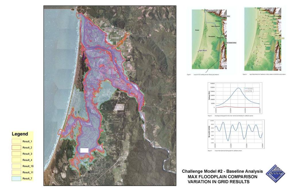
6 Challenge Model 2 Tidally Influenced Riverine and Coastal System: Challenge Model 2 represents a tidally influenced floodplain and riverine system along the California Coast. The data provided for Challenge 2, included source data from a mixture of both Statute and Metric Units. There are no bridge structures within the model domain. The data was obtained directly from the documentation for the effective models submitted to FEMA. Data Provided: Model Boundary (included significant amount of Ocean area) Terrain via 5 meter Digital Elevation Model (DEM) Aerial Photograph Inflow Hydrograph for main Riverine and Tributary Ocean Tide Information coincident with hydrograph High water marks from Record Event data. Requested Deliverables: Shape file showing the maximum extent of flooding Table comparing results to the High Water Marks. The real location for Challenge Model 2 is the???. Five(5) Mesh based models and Eight(8) grid based models were submitted for this Challenge. Model Type Challenge 2 Flexible Mesh 2 Mesh (no 1D) 3 Mesh (1D Coupled) 0 Grid (no 1D) 6 Grid (1D Coupled) 2 TOTAL 13 6


7 Mesh Based Model Submittal Data for Challenge 2: Grid Based Model Submittal Data for Challenge 2: The diversity of maximum floodplain limit submittals that were received is shown in the following exhibits: MESH: 7
8 GRID: 8
 caused 2 high water marks to show their water elevations below the terrain elevation.")
9 Critical Modeler Identified Issues affecting the Consistency of the Results were: The lack of terrain data provided below the water surface in the main riverine complicated the ability of the modelers to match the high water mark data. It was noted that the coarseness of the terrain data (5 meters) caused 2 high water marks to show their water elevations below the terrain elevation. It was noted that the terrain provided was different than the terrain in the 1960 s when the high water mark event occurred. This also complicated high water mark matching. Most of the modelers performed an iterative approach in their modeling, by adjusting n values to find a good match to the high water mark data. Most found that an n value of produced the best match, and those that made this assumption had very similar results, even though different software programs were used in the analysis. One submittal was provided using expected published n values, which resulted in a very large floodplain compared to the others, and this submittal did not match the high water mark data very well. Limited time provided (available) to process the model data limited the iteration process. 9

10 Challenge Model 3 Non Urban Riverine System: Challenge Model 3 represents a typical non urban stream of the California Central Valley, originating near the Sierra Nevada Foothills and conveying runoff to the West into the Central Valley Flood Management System. These streams tend to be natural, with large amounts of conveyance in their upper reaches. As the streams progress downstream, their conveyance capacity gradually reduces. At some point nearing the valley floor, typically levees have been constructed to contain normal floods within the conveyance systems. The data provided for Challenge 1, included source data with only Statute Units. The data was obtained directly from preliminary information being used in the State of California s Central Valley Flood Evaluation and Delineation Program (CVFED). FEMA s LAMP, a new criteria for evaluating non accredited levee failure floodplains was offered to the modelers. They were told that the levees were to be assumed to be structurally stable even when overtopped. Overtopping flows were intended to occur. As a bonus, a modeling option was provided to evaluate potential transmission losses from infiltration. Data Provided: Model Boundary Terrain via LiDAR LAS files. Optional pre processed high resolution Gridded Regular Network (GMG format) based terrain files were also provided. Supplemental Survey Points and Breaklines. Bathymetry and wet survey Data. High Resolution Aerial Photograph Structure survey information and dimensions/locations. Inflow Hydrographs at upstream end of stream Land Use Data Soils Data Levee locations Requested Deliverables: Shape file showing the maximum extent of flooding Outflow Hydrograph Requested Deliverables for Bonus Scenario: Shape file showing the maximum extent of flooding Outflow Hydrograph 10
 Mesh based models and Ten(4) grid based models were submitted for this Challenge, and for the Bonus Scenario Two(2) additional grid based")
 1 0 Mesh (1D Coupled) 0 0 Grid (no 1D) 1 0 Grid (1D Coupled) 3 2 TOTAL 5 2 Mesh")
11 The real location for Challenge Model 3 is Ash Slough, a tributary to the Upper San Joaquin River. One(1) Mesh based models and Ten(4) grid based models were submitted for this Challenge, and for the Bonus Scenario Two(2) additional grid based models were also submitted. Model Type Challenge 3 Challenge 3+ Flexible Mesh 0 0 Mesh (no 1D) 1 0 Mesh (1D Coupled) 0 0 Grid (no 1D) 1 0 Grid (1D Coupled) 3 2 TOTAL 5 2 Mesh Based Model Submittal Data for Challenge 3: Grid Based Model Submittal Data for Challenge 3: Effective floodplains for this stream have not yet been mapped by the CVFED program. 11


12 The diversity of maximum floodplain limit submittals that were received is shown in the following exhibits: MESH: GRID: 12

13 GRID for the Bonus Models (with estimated transmission losses factored) Critical Modeler Identified Issues affecting the Consistency of the Results were: The provided terrain was cumbersome and difficult for some modelers to manage and utilize to develop modeling domains with. Roughly 18GB of terrain data was provided. It was later noted that this is less than 2% of the terrain for one of the five modeling areas of the CVFED. There was difficulty interpreting the types of data points that were provided in the LAS files, and in one case some non terrain based data was included as terrain. Modeling area too large for pro bono efforts. Some of the Levee data included 3D elevations which did not match the terrain. Users were suggested to recomputed the levee elevations to match the terrain information. Limited time provided (available) to process the model data. 13
14 Overall Summary of Submittals Received by FMA: Model Type Challenge 1 Challenge 2 Challenge 3 Challenge 3+ TOTAL Flexible Mesh Mesh (no 1D) Mesh (1D Coupled) Grid (no 1D) Grid (1D Coupled) TOTAL Submitting Agencies D Software Vender s Applications Used Understanding the Nature of Challenge Models vs. Benchmarking: Benchmarking tests are constructed such that results can be compared to verified and known results for a controlled situation. They test the capability, accuracy and speed for each software program to solve the computational domain. We understand that the UK Environmental Agency is currently updating their Benchmarking study for 2 D and 3 D hydraulic analysis software. As they are currently preparing this analysis, FMA did not want to duplicate their efforts. The concept of the Challenge Model was developed to provide a means to deliver complex model sets to a group of modelers, wherein certain assumptions and derivations are necessary to be able to create a model domain, compute it, and convert those results into flood limits, elevations and flow rates. As opposed to just testing the software, in benchmarking, the Challenge Models test the joint efforts of the modeler and the software. This is closer to the real situation an agency such as FEMA is dealing with. This also opened the door for modelers other than software venders to volunteer their capabilities and talents to this effort. The 1 Day of 2 D symposium on September 4 th, 2012 dealt directly with trying to itemize and understand the variety of issues that can and have resulted in these situations. Examples from the Challenge Models were provided to those in attendance at this symposium and may be reviewed further in additional discussions of these issues. Lesson s Learned: Internal Technical Review of model data needs to be more thorough. Need to provide more time for models to be prepared Limit the items being tested in each model to help accelerate model creation time Provide more complete and uniform data sets to modelers There is a need to do more Challenges in the future 14
15 2 D models have an appetite for large amounts of data, which can contribute to a diversity of computational results via processing differences, but often it is also shown that it is the mere presence of having that data available during the flood mapping process that leads to highly complex flood maps with questionable details. What s Next: FEMA and UC Davis will be cooperatively assembling a Blue Ribbon Panel of experts to review issues associated with using 2 D models to prepare FEMA flood mapping products. Some suggested topics we have already received for potential future 2 D Challenge Models are: 2 D Integrated Hydrology Analysis. Urban Isolated Floodplains (combination storm drain and stream) Floodway Analysis LAMP Alluvial Analysis Sediment Transport and Mobile Bed Analysis Levee Breach Dam Breach Converting 2 D results directly to mapping (no modeling) If you have any additional suggestions or model ideas, please contact Thomas Plummer (thomas@civilsolutions.com) 15
Urban Floodplain modeling- Application of Two-Dimensional Analyses to Refine Results
 Urban Floodplain modeling- Application of Two-Dimensional Analyses to Refine Results Prabharanjani Madduri, P.E., CFM Mathini Sreetharan, Ph.D., P.E., CFM Hydraulic modeling of urban areas and issues Modeling
2D Model Implementation for Complex Floodplain Studies. Sam Crampton, P.E., CFM Dewberry
 2D Model Implementation for Complex Floodplain Studies Sam Crampton, P.E., CFM Dewberry 2D Case Studies Case Study 1 Rain-on-Grid 2D floodplain simulation for unconfined flat topography in coastal plain
2-D Hydraulic Modeling Theory & Practice
 2-D Hydraulic Modeling Theory & Practice Author: Maged A. Aboelata, PhD, PE, CFM Presenter: Heather Zhao, PE, CFM October 2017 Presentation Outline * 1-D vs. 2-D modeling * Theory of 2-D simulation * Commonly
2D Large Scale Automated Engineering for FEMA Floodplain Development in South Dakota. Eli Gruber, PE Brooke Conner, PE
 2D Large Scale Automated Engineering for FEMA Floodplain Development in South Dakota Eli Gruber, PE Brooke Conner, PE Project Acknowledgments FEMA Region 8 Staff: Brooke Conner, PE Casey Zuzak, GISP Ryan
2D Modeling for Approximate Areas. Monica S. Urisko, P.E. CFM
 2D Modeling for Approximate Areas Monica S. Urisko, P.E. CFM Ferrin P. Affleck, P.E. CFM Outline Types of Modeling Available Steady vs Unsteady 1D vs 2D Software available Basics of 2D modeling Inputs
Harris County Flood Control District HEC-RAS 2D Modeling Guidelines (Standardizing HEC-RAS 2D Models for Submittal Within Harris County)
") Harris County Flood Control District HEC-RAS 2D Modeling Guidelines (Standardizing HEC-RAS 2D Models for Submittal Within Harris County) Presented by: April 27, 2017 Matthew Zeve, P.E., CFM Harris County
Harris County Flood Control District HEC-RAS 2D Modeling Guidelines (Standardizing HEC-RAS 2D Models for Submittal Within Harris County) Presented by: April 27, 2017 Matthew Zeve, P.E., CFM Harris County
Upper Trinity River Corridor Development Certificate Model Updates. Flood Management Task Force Meeting April 20, 2018
 Upper Trinity River Corridor Development Certificate Model Updates Flood Management Task Force Meeting April 20, 2018 Agenda Review of the Phase II Upper Trinity Watershed CDC Model Development Hydrology
2014 AWRA Annual Water Resources Conference November 5, 2014 Tysons Corner, VA
 2014 AWRA Annual Water Resources Conference November 5, 2014 Tysons Corner, VA HEC-RAS Overview, History, & Future How HEC-RAS Works Model Development Standard FEMA Assumptions Building A Model FEMA Levels
Linear Routing: Floodrouting. HEC-RAS Introduction. Brays Bayou. Uniform Open Channel Flow. v = 1 n R2/3. S S.I. units
 Linear Routing: Floodrouting HEC-RAS Introduction Shirley Clark Penn State Harrisburg Robert Pitt University of Alabama April 26, 2004 Two (2) types of floodrouting of a hydrograph Linear Muskingum Reservoir
A Comparative Study of HEC-RAS 2D, TUFLOW, & Mike 21 Model Benchmark Testing
 A Comparative Study of HEC-RAS 2D, TUFLOW, & Mike 21 Model Benchmark Testing June 2016 Presented by: Murari Paudel, PhD, PE, CFM Soledad B Roman, EIT John Prichard, PE, CFM Wood Rodgers Inc. Sacramento,
Hydraulics and Floodplain Modeling Modeling with the Hydraulic Toolbox
 v. 9.1 WMS 9.1 Tutorial Hydraulics and Floodplain Modeling Modeling with the Hydraulic Toolbox Learn how to design inlet grates, detention basins, channels, and riprap using the FHWA Hydraulic Toolbox
Advanced 1D/2D Modeling Using HEC-RAS
 Advanced 1D/2D Modeling Using HEC-RAS Davis, California Objectives This is an advanced course in applying computer program HEC-RAS. The course provides participants with the knowledge to effectively use
GPU - Next Generation Modeling for Catchment Floodplain Management. ASFPM Conference, Grand Rapids (June 2016) Chris Huxley
 Chris Huxley") GPU - Next Generation Modeling for Catchment Floodplain Management ASFPM Conference, Grand Rapids (June 2016) Chris Huxley Presentation Overview 1. What is GPU flood modeling? 2. What is possible using
GPU - Next Generation Modeling for Catchment Floodplain Management ASFPM Conference, Grand Rapids (June 2016) Chris Huxley Presentation Overview 1. What is GPU flood modeling? 2. What is possible using
v TUFLOW-2D Hydrodynamics SMS Tutorials Time minutes Prerequisites Overview Tutorial
 v. 12.2 SMS 12.2 Tutorial TUFLOW-2D Hydrodynamics Objectives This tutorial describes the generation of a TUFLOW project using the SMS interface. This project utilizes only the two dimensional flow calculation
2D Hydraulic Modeling, Steering Stream Restoration Design
 2D Hydraulic Modeling, Steering Stream Restoration Design PREPARED FOR: EcoStream 2018 Stream Ecology & Restoration Conference Presented By: Matthew D. Gramza, P.E., CFM, CPESC Civil & Environmental Consultants,
Automated Enforcement of High Resolution Terrain Models April 21, Brian K. Gelder, PhD Associate Scientist Iowa State University
 Automated Enforcement of High Resolution Terrain Models April 21, 2015 Brian K. Gelder, PhD Associate Scientist Iowa State University Problem Statement High resolution digital elevation models (DEMs) should
Generalisation of Topographic resolution for 2D Urban Flood Modelling. Solomon D. Seyoum Ronald Price Zoran Voijnovic
 Generalisation of Topographic resolution for 2D Urban Flood Modelling Solomon D. Seyoum Ronald Price Zoran Voijnovic Outline Introduction Urban Flood Modelling and Topographic data DTM Generalisation Remedial
UNDERSTAND HOW TO SET UP AND RUN A HYDRAULIC MODEL IN HEC-RAS CREATE A FLOOD INUNDATION MAP IN ARCGIS.
 CE 412/512, Spring 2017 HW9: Introduction to HEC-RAS and Floodplain Mapping Due: end of class, print and hand in. HEC-RAS is a Hydrologic Modeling System that is designed to describe the physical properties
Day 1. HEC-RAS 1-D Training. Rob Keller and Mark Forest. Break (9:45 am to 10:00 am) Lunch (12:00 pm to 1:00 pm)
 Lunch (12:00 pm to 1:00 pm)") Day 1 HEC-RAS 1-D Training Rob Keller and Mark Forest Introductions and Course Objectives (8:00 am to 8:15 am) Introductions: Class and Content Module 1 Open Channel Hydraulics (8:15 am to 9:45 am) Lecture
Day 1 HEC-RAS 1-D Training Rob Keller and Mark Forest Introductions and Course Objectives (8:00 am to 8:15 am) Introductions: Class and Content Module 1 Open Channel Hydraulics (8:15 am to 9:45 am) Lecture
Introduction Surface Water Modeling System (SMS) & Case Study using SMS 2D Modeling Software
 & Case Study using SMS 2D Modeling Software") A.D. Latornell Conservation Symposium November 18, 2015 Introduction Surface Water Modeling System (SMS) & Case Study using SMS 2D Modeling Software Dr. Bahar SM P.Geo.(Ltd), P Eng 1 Topics Education,
A.D. Latornell Conservation Symposium November 18, 2015 Introduction Surface Water Modeling System (SMS) & Case Study using SMS 2D Modeling Software Dr. Bahar SM P.Geo.(Ltd), P Eng 1 Topics Education,
The HEC-RAS Model Refresher
 The HEC-RAS Model Refresher Minmin Shu P.E. Transportation Review Unit Water Resources Division Michigan Department of Environmental Quality 12-6-2018 What Does the HEC-RAS Mean RAS----River Analysis System
Objectives This tutorial will introduce how to prepare and run a basic ADH model using the SMS interface.
 v. 12.1 SMS 12.1 Tutorial Objectives This tutorial will introduce how to prepare and run a basic ADH model using the SMS interface. Prerequisites Overview Tutorial Requirements ADH Mesh Module Scatter
MIKE 21 Flow Model FM. Parallelisation using GPU. Benchmarking report
 MIKE 21 Flow Model FM Parallelisation using Benchmarking report MIKE by DHI 2014 DHI headquarters Agern Allé 5 DK-2970 Hørsholm Denmark +45 4516 9200 Telephone +45 4516 9333 Support +45 4516 9292 Telefax
Connecting 1D and 2D Domains
 Connecting 1D and 2D Domains XP Solutions has a long history of Providing original, high-performing software solutions Leading the industry in customer service and support Educating our customers to be
Efficiency and Accuracy of Importing HEC RAS Datafiles into PCSWMM and SWMM5
 5 Efficiency and Accuracy of Importing HEC RAS Datafiles into PCSWMM and SWMM5 Karen Finney, Rob James, William James and Tiehong Xiao An advantage of USEPA s SWMM5 is its capability to dynamically model
HECRAS 2D: Are you ready for the revolution in the world of hydraulic modeling?
 HECRAS 2D: Are you ready for the revolution in the world of hydraulic modeling? Rishab Mahajan, Emily Campbell and Matt Bardol March 8, 2017 Outline Reasons for hydraulic modeling 1D Modeling 2D Modeling-
Introducion to Hydrologic Engineering Centers River Analysis System (HEC- RAS) Neena Isaac Scientist D CWPRS, Pune -24
 Neena Isaac Scientist D CWPRS, Pune -24") Introducion to Hydrologic Engineering Centers River Analysis System (HEC- RAS) Neena Isaac Scientist D CWPRS, Pune -24 One dimensional river models (1-D models) Assumptions Flow is one dimensional Streamline
Introducion to Hydrologic Engineering Centers River Analysis System (HEC- RAS) Neena Isaac Scientist D CWPRS, Pune -24 One dimensional river models (1-D models) Assumptions Flow is one dimensional Streamline
WMS 9.1 Tutorial Hydraulics and Floodplain Modeling Floodplain Delineation Learn how to us the WMS floodplain delineation tools
 v. 9.1 WMS 9.1 Tutorial Hydraulics and Floodplain Modeling Floodplain Delineation Learn how to us the WMS floodplain delineation tools Objectives Experiment with the various floodplain delineation options
Flood Inundation Mapping using HEC-RAS
 Flood Inundation Mapping using HEC-RAS Goodell, C. 1 ; Warren, C. 2 WEST Consultants, 2601 25 th St SE, Suite 450, Salem, OR 97302. Abstract Flood inundation mapping is an important tool for municipal
Application of 2-D Modelling for Muda River Using CCHE2D
 Application of 2-D Modelling for Muda River Using CCHE2D ZORKEFLEE ABU HASAN, Lecturer, River Engineering and Urban Drainage Research Centre (REDAC), Universiti Sains Malaysia, Engineering Campus, Seri
v. 9.1 WMS 9.1 Tutorial Watershed Modeling HEC-1 Interface Learn how to setup a basic HEC-1 model using WMS
 v. 9.1 WMS 9.1 Tutorial Learn how to setup a basic HEC-1 model using WMS Objectives Build a basic HEC-1 model from scratch using a DEM, land use, and soil data. Compute the geometric and hydrologic parameters
MIKE 21 Flow Model FM. Parallelisation using GPU. Verification report
 MIKE 21 Flow Model FM Parallelisation using GPU Verification report MIKE by DHI 2014 DHI headquarters Agern Allé 5 DK-2970 Hørsholm Denmark +45 4516 9200 Telephone +45 4516 9333 Support +45 4516 9292 Telefax
Appendix E. HEC-RAS and HEC-Ecosystem Functions Models
 Appendix E HEC-RAS and HEC-Ecosystem Functions Models 1 Appendix E: Modeled Reaches for the Connecticut River Watershed application of HEC-RAS Separate from the report for the Decision Support System of
CHAPTER 7 FLOOD HYDRAULICS & HYDROLOGIC VIVEK VERMA
 CHAPTER 7 FLOOD HYDRAULICS & HYDROLOGIC VIVEK VERMA CONTENTS 1. Flow Classification 2. Chezy s and Manning Equation 3. Specific Energy 4. Surface Water Profiles 5. Hydraulic Jump 6. HEC-RAS 7. HEC-HMS
Representing Detail in Large Hydraulic Models: Lower Thames and Humber Estuary. Neil Hunter, Kevin Haseldine and Matthew Scott
 Representing Detail in Large Hydraulic Models: Lower Thames and Humber Estuary Neil Hunter, Kevin Haseldine and Matthew Scott Overview What do we mean by detail? Lower Thames Humber Estuary How is software
Use of measured and interpolated crosssections
 Use of measured and interpolated crosssections in hydraulic river modelling Y. Chen/, R. Crowded & R. A. Falconer^ ^ Department of Civil & Environmental Engineering, University ofbradford, Bradford, West
MEMORANDUM. Corona Subdivision XP Storm Evaluation. Date: March 5, Curt Bates, City of Petaluma. David S. Smith, P.E., WEST Consultants, Inc.
 MEMORANDUM Project: Corona Subdivision XP Storm Evaluation Subject: Results Summary Date: March 5, 2013 To: Curt Bates, City of Petaluma No. C056132 EXP. 12/31/14 From: David S. Smith, P.E., WEST Consultants,
BDCP Effects Analysis: 2D Hydrodynamic Modeling of the Fremont Weir Diversion Structure
 Hydrology Hydraulics Geomorphology Design Field Services BDCP Effects Analysis: 2D Hydrodynamic Modeling of the Fremont Weir Diversion Structure Prepared for SAIC and the California Department of Water
The TUFLOW Link. Past, Present and Future. Stephanie Dufour
 The TUFLOW Link Past, Present and Future Stephanie Dufour stephanie.dufour@bmtwbm.co.uk Contents PAST Software background Thames Embayments Inundation Study PRESENT Flood Modeller -TUFLOW link Flood Modeller
Introduction to MIKE FLOOD
 Introduction to MIKE FLOOD HYDROEUROPE, Sophia-Antipolis, February 2011 Julie Landrein, DHI Denmark Introduction to MIKE FLOOD - Introduction to MIKE FLOOD - 1D Modelling: MIKE 11, MIKE URBAN - 2D Modelling:
Boundaries of 1D 2D modelling. Suzanne Callaway Senior Hydraulic Modeller
 Boundaries of 1D 2D modelling Suzanne Callaway Senior Hydraulic Modeller Introduction Why is it important to define 1D 2D boundaries carefully? Defining boundaries between 1D and 2D models (Flood Modeller
High performance computing in an operational setting. Johan
 High performance computing in an operational setting Johan Hartnack(jnh@dhigroup.com) DHI in short We re an independent, private and not-for-profit organisation Our people are highly qualified 80% of our
Comparing 2D Approaches for Complex FEMA Studies
 Comparing 2D Approaches for Complex FEMA Studies Presented by: Ted Cassidy, P.E., PH (STARR2-Dewberry) Sam Crampton, P.E., CFM (STARR2-Dewberry) Mike DePue, P.E., CFM (STARR2-Atkins) Agenda Introduction
The CaMa-Flood model description
 Japan Agency for Marine-Earth cience and Technology The CaMa-Flood model description Dai Yamazaki JAMTEC Japan Agency for Marine-Earth cience and Technology 4 th ep, 2015 Concepts of the CaMa-Flood development
Prof. B.S. Thandaveswara. The computation of a flood wave resulting from a dam break basically involves two
 41.4 Routing The computation of a flood wave resulting from a dam break basically involves two problems, which may be considered jointly or seperately: 1. Determination of the outflow hydrograph from the
PRACTICAL UNIT 1 exercise task
 Practical Unit 1 1 1 PRACTICAL UNIT 1 exercise task Developing a hydraulic model with HEC RAS using schematic river geometry data In the course of practical unit 1 we prepare the input for the execution
Lidar Talking Points Status of lidar collection in Pennsylvania Estimated cost and timeline
 Lidar Talking Points Pennsylvania has an immediate need for new lidar (topographic) data coverage. Some uses of the data are enumerated later in this document. USGS has calculated an average return on
FLOODPLAIN MODELING USING HEC-RAS
 H A E S T A D M E T H O D S FLOODPLAIN MODELING USING HEC-RAS F i r s t E d i t i o n Authors Haestad Methods Gary Dyhouse Jennifer Hatchett Jeremy Benn Managing Editor Colleen Totz Editors David Klotz,
Watershed Modeling HEC-HMS Interface
 v. 10.1 WMS 10.1 Tutorial Learn how to set up a basic HEC-HMS model using WMS Objectives Build a basic HEC-HMS model from scratch using a DEM, land use, and soil data. Compute the geometric and hydrologic
This tutorial introduces the HEC-RAS model and how it can be used to generate files for use with the HEC-RAS software.
 v. 12.3 SMS 12.3 Tutorial Objectives This tutorial introduces the model and how it can be used to generate files for use with the software. Prerequisites Overview Tutorial Requirements 5.0 Mesh Module
WMS 10.0 Tutorial Hydraulics and Floodplain Modeling HY-8 Modeling Wizard Learn how to model a culvert using HY-8 and WMS
 v. 10.0 WMS 10.0 Tutorial Hydraulics and Floodplain Modeling HY-8 Modeling Wizard Learn how to model a culvert using HY-8 and WMS Objectives Define a conceptual schematic of the roadway, invert, and downstream
On the issues associated with 2-D modeling for flood mapping purposes
 On the issues associated with 2-D modeling for flood mapping purposes Devinder S. Dhillon, Fabián A. Bombardelli, Wm. E. Fleenor and Kaveh Zamani Source: http://www.eonfusionflood.com/applications Table
LIDAR MAPPING FACT SHEET
 1. LIDAR THEORY What is lidar? Lidar is an acronym for light detection and ranging. In the mapping industry, this term is used to describe an airborne laser profiling system that produces location and
ISIS Free & ISIS Professional Quick Start Guide
 ISIS Free & ISIS Professional Cost effective, integrated modelling solutions Think saving, think ISIS, think Halcrow This quick start guide enables first time users to quickly understand how to use ISIS
Evolution of an Integrated 1D/2D Modeling Package for Urban Drainage
 18 Evolution of an Integrated 1D/2D Modeling Package for Urban Drainage Thomas E. Barnard, Anthony W. Kuch, Geoffrey R. Thompson, Sudesh Mudaliar and Brett C. Phillips Recent flooding events in North America
Prepared for CIVE 401 Hydraulic Engineering By Kennard Lai, Patrick Ndolo Goy & Dr. Pierre Julien Fall 2015
 Prepared for CIVE 401 Hydraulic Engineering By Kennard Lai, Patrick Ndolo Goy & Dr. Pierre Julien Fall 2015 Contents Introduction General Philosophy Overview of Capabilities Applications Computational
Verification and Validation of HEC-RAS 5.1
 Verification and Validation of HEC-RAS 5.1 Gary Brunner 1, P.E., D. WRE, M.ASCE Dr. Alex Sanchez 1 Dr. Tom Molls 2 Dr. David Parr 3 1. USACE Hydrologic Engineering Center, Davis, CA 2. David Ford Consulting
ISIS 1D. Quick Start Guide. Cost effective, integrated software solutions ch2mhill.com/isis
 ISIS 1D Quick Start Guide Cost effective, integrated software solutions 0845 094 7990 ch2mhill.com/isis softwaresupport@ch2m.com Table of Contents Overview... 3 1. Starting ISIS and Basic Concepts... 3
COMPARISON OF NUMERICAL HYDRAULIC MODELS APPLIED TO THE REMOVAL OF SAVAGE RAPIDS DAM NEAR GRANTS PASS, OREGON
 COMPARISON OF NUMERICAL HYDRAULIC MODELS APPLIED TO THE REMOVAL OF SAVAGE RAPIDS DAM NEAR GRANTS PASS, OREGON Jennifer Bountry, Hydraulic Engineer, Bureau of Reclamation, Denver, CO, jbountry@do.usbr.gov;
Large scale flexible mesh 2D modelling of the Lower Namoi Valley
 Large scale flexible mesh 2D modelling of the Lower Namoi Valley C. Mackay 1, S. Suter 1, N. Albert 2, S. Morton 2, K. Yamagata 1 1 DHI Water and Environment, 50 Clarence Street, Sydney NSW 2000 2 Office
Tips for a Good Meshing Experience
 Tips for a Good Meshing Experience Meshes are very powerful and flexible for modeling 2D overland flows in a complex urban environment. However, complex geometries can be frustrating for many modelers
Using 2D Schemes to Model Energy Losses at Structures and Bends Beware of Pretty Images!
 Using 2D Schemes to Model Energy Losses at Structures and Bends Beware of Pretty Images! Bill Syme BMT WBM Software Business Manager 2D: Looks impressive, but is it accurate? 2 Form Losses Energy dissipated
v. 8.4 Prerequisite Tutorials Watershed Modeling Advanced DEM Delineation Techniques Time minutes
 v. 8.4 WMS 8.4 Tutorial Modeling Orange County Rational Method GIS Learn how to define a rational method hydrologic model for Orange County (California) from GIS data Objectives This tutorial shows you
Flood Control Structures Sometimes Neither Fish Nor Fowl
 Proud Titanium Sponsor of the ASFPM 2016 Annual Conference Flood Control Structures Sometimes Neither Fish Nor Fowl David Rubenstein, CFM Jim Murphy, PE, CFM Agenda Approach Study Area Flood Control System
Hydrologic Modeling using HEC-HMS
 Hydrologic Modeling using HEC-HMS CE 412/512 Spring 2017 Introduction The intent of this exercise is to introduce you to the structure and some of the functions of the HEC-Hydrologic Modeling System (HEC-HMS),
Integrated Stormwater Management. March 27, 2014
 Integrated Stormwater Management March 27, 2014 Master Plan Development + Alternatives to Address Flooding + Riverine Flooding + Level of Service (LOS) analysis + Identify Capitol Improvement Projects
Objectives This tutorial shows how to build a Sedimentation and River Hydraulics Two-Dimensional (SRH-2D) simulation.
 simulation.") v. 12.1 SMS 12.1 Tutorial Objectives This tutorial shows how to build a Sedimentation and River Hydraulics Two-Dimensional () simulation. Prerequisites SMS Overview tutorial Requirements Model Map Module
v. 12.1 SMS 12.1 Tutorial Objectives This tutorial shows how to build a Sedimentation and River Hydraulics Two-Dimensional () simulation. Prerequisites SMS Overview tutorial Requirements Model Map Module
WMS 9.0 Tutorial Hydraulics and Floodplain Modeling HEC-RAS Analysis Learn how to setup a basic HEC-RAS analysis using WMS
 v. 9.0 WMS 9.0 Tutorial Hydraulics and Floodplain Modeling HEC-RAS Analysis Learn how to setup a basic HEC-RAS analysis using WMS Objectives Learn how to build cross sections, stream centerlines, and bank
v Prerequisite Tutorials GSSHA Modeling Basics Stream Flow GSSHA WMS Basics Creating Feature Objects and Mapping their Attributes to the 2D Grid
 v. 10.1 WMS 10.1 Tutorial GSSHA Modeling Basics Developing a GSSHA Model Using the Hydrologic Modeling Wizard in WMS Learn how to setup a basic GSSHA model using the hydrologic modeling wizard Objectives
WMS 8.4 Tutorial Watershed Modeling MODRAT Interface (GISbased) Delineate a watershed and build a MODRAT model
 Delineate a watershed and build a MODRAT model") v. 8.4 WMS 8.4 Tutorial Watershed Modeling MODRAT Interface (GISbased) Delineate a watershed and build a MODRAT model Objectives Delineate a watershed from a DEM and derive many of the MODRAT input parameters
v. 8.4 WMS 8.4 Tutorial Watershed Modeling MODRAT Interface (GISbased) Delineate a watershed and build a MODRAT model Objectives Delineate a watershed from a DEM and derive many of the MODRAT input parameters
Watershed Modeling Advanced DEM Delineation
 v. 10.1 WMS 10.1 Tutorial Watershed Modeling Advanced DEM Delineation Techniques Model manmade and natural drainage features Objectives Learn to manipulate the default watershed boundaries by assigning
Chapter 16. Table of Contents
 Table of Contents BANK FAILURE CALCULATIONS IN HEC-6T...16-1 Introduction...16-1 Approach...16-2 Conceptual Model...16-3 Theoretical Development...16-4 Two Foot Test...16-6 Mass Conservation...16-6 Command
This tutorial shows how to build a Sedimentation and River Hydraulics Two-Dimensional (SRH-2D) simulation. Requirements
 simulation. Requirements") v. 13.0 SMS 13.0 Tutorial Objectives This tutorial shows how to build a Sedimentation and River Hydraulics Two-Dimensional () simulation. Prerequisites SMS Overview tutorial Requirements Model Map Module
v. 13.0 SMS 13.0 Tutorial Objectives This tutorial shows how to build a Sedimentation and River Hydraulics Two-Dimensional () simulation. Prerequisites SMS Overview tutorial Requirements Model Map Module
Updated on November 10, 2017
 CIVE 7397 Unsteady flows in Rivers and Pipe Networks/Stormwater Management and Modeling / Optimization in Water Resources Engineering Updated on November 10, 2017 Tutorial on using HEC-GeoRAS 10.1 (or
Appendix E-1. Hydrology Analysis
 Appendix E-1 Hydrology Analysis July 2016 HYDROLOGY ANALYSIS For Tentative Tract 20049 City of Chino Hills County of San Bernardino Prepared For: 450 Newport Center Drive, Suite 300 Newport Beach, CA 92660
Overview. 1. Aerial LiDAR in Wisconsin (20 minutes) 2. Demonstration of data in CAD (30 minutes) 3. High Density LiDAR (20 minutes)
 2. Demonstration of data in CAD (30 minutes) 3. High Density LiDAR (20 minutes)") Overview 1. Aerial LiDAR in Wisconsin (20 minutes) 2. Demonstration of data in CAD (30 minutes) 3. High Density LiDAR (20 minutes) 4. Aerial lidar technology advancements (15 minutes) 5. Q & A 1. Aerial
Overview 1. Aerial LiDAR in Wisconsin (20 minutes) 2. Demonstration of data in CAD (30 minutes) 3. High Density LiDAR (20 minutes) 4. Aerial lidar technology advancements (15 minutes) 5. Q & A 1. Aerial
v Modeling Orange County Unit Hydrograph GIS Learn how to define a unit hydrograph model for Orange County (California) from GIS data
 from GIS data") v. 10.1 WMS 10.1 Tutorial Modeling Orange County Unit Hydrograph GIS Learn how to define a unit hydrograph model for Orange County (California) from GIS data Objectives This tutorial shows how to define
v. 10.1 WMS 10.1 Tutorial Modeling Orange County Unit Hydrograph GIS Learn how to define a unit hydrograph model for Orange County (California) from GIS data Objectives This tutorial shows how to define
2015 HDR, all rights reserved.
 2015 HDR, all rights reserved. An Alternative to HEC-GEORAS: Overview & Comparison of AutoCAD River & Flood Analysis Module Ron Branyon, PE, CFM George Doubleday, EIT, CFM Brandon Hilbrich, PE, CFM TFMA
WMS 9.1 Tutorial GSSHA Modeling Basics Stream Flow Integrate stream flow with your GSSHA overland flow model
 v. 9.1 WMS 9.1 Tutorial Integrate stream flow with your GSSHA overland flow model Objectives Learn how to add hydraulic channel routing to your GSSHA model and how to define channel properties. Learn how
TUFLOW Two & one-dimensional Unsteady FLOW Software for Rivers, Estuaries and Coastal Waters
 TUFLOW Two & one-dimensional Unsteady FLOW Software for Rivers, Estuaries and Coastal Waters W.J.Syme B.E.(Hons), M.Eng.Sc.(Res) - WBM Oceanics Australia Summary: Once limited to coastal hydraulics, two-dimensional
STRUCTURED MESH GENERATION ALONG LOUISIANA-MISSISSIPPI COASTLINE FOR SIMULATION OF COASTAL PROCESSES
 STRUCTURED MESH GENERATION ALONG LOUISIANA-MISSISSIPPI COASTLINE FOR SIMULATION OF COASTAL PROCESSES Yaoxin Zhang 1, Yafei Jia 2, Mustafa S. Altinakar 3, Yan Ding 4, Vijay Ramalingam 5, and Soumendra N.
v SMS Tutorials SRH-2D Prerequisites Requirements SRH-2D Model Map Module Mesh Module Data files Time
 v. 11.2 SMS 11.2 Tutorial Objectives This tutorial shows how to build a Sedimentation and River Hydraulics Two-Dimensional () simulation using SMS version 11.2 or later. Prerequisites SMS Overview tutorial
Reality Check: Processing LiDAR Data. A story of data, more data and some more data
 Reality Check: Processing LiDAR Data A story of data, more data and some more data Red River of the North Red River of the North Red River of the North Red River of the North Introduction and Background
Objectives This tutorial demonstrates how to perform unsteady sediment transport simulations in SRH-2D.
 SMS v. 12.2 SRH-2D Tutorial Objectives This tutorial demonstrates how to perform unsteady sediment transport simulations in SRH-2D. Prerequisites SMS Overview tutorial SRH-2D SRH-2D Sediment Transport
River inundation modelling for risk analysis
 River inundation modelling for risk analysis L. H. C. Chua, F. Merting & K. P. Holz Institute for Bauinformatik, Brandenburg Technical University, Germany Abstract This paper presents the results of an
INTERNATIONAL JOURNAL OF CIVIL AND STRUCTURAL ENGINEERING Volume 2, No 3, 2012
 INTERNATIONAL JOURNAL OF CIVIL AND STRUCTURAL ENGINEERING Volume 2, No 3, 2012 Copyright 2010 All rights reserved Integrated Publishing services Research article ISSN 0976 4399 Efficiency and performances
NON STRUCTURAL STORMWATER STRATEGIES (NJAC 7:8-5.3) - ATTACHMENT G
 - ATTACHMENT G") NON STRUCTURAL STORMWATER STRATEGIES (NJAC 7:8-5.3) - ATTACHMENT G 1. Has the applicant identified the Nonstructural Stormwater Strategies which are incorporated into Project and where they are located
NON STRUCTURAL STORMWATER STRATEGIES (NJAC 7:8-5.3) - ATTACHMENT G 1. Has the applicant identified the Nonstructural Stormwater Strategies which are incorporated into Project and where they are located
Cross Sections, Profiles, and Rating Curves. Viewing Results From The River System Schematic. Viewing Data Contained in an HEC-DSS File
 C H A P T E R 9 Viewing Results After the model has finished the steady or unsteady flow computations the user can begin to view the output. Output is available in a graphical and tabular format. The current
WMS 8.4 Tutorial Hydraulics and Floodplain Modeling Simplified Dam Break Learn how to run a dam break simulation and delineate its floodplain
 v. 8.4 WMS 8.4 Tutorial Hydraulics and Floodplain Modeling Simplified Dam Break Learn how to run a dam break simulation and delineate its floodplain Objectives Setup a conceptual model of stream centerlines
FLOODPLAIN MODELING MANUAL. HEC-RAS Procedures for HEC-2 Modelers
 FLOODPLAIN MODELING MANUAL HEC-RAS Procedures for HEC-2 Modelers Federal Emergency Management Agency Mitigation Directorate 500 C Street, SW Washington, DC 20472 April 2002 Floodplain Modeling Manual HEC-RAS
WMS 10.1 Tutorial Hydraulics and Floodplain Modeling Simplified Dam Break Learn how to run a dam break simulation and delineate its floodplain
 v. 10.1 WMS 10.1 Tutorial Hydraulics and Floodplain Modeling Simplified Dam Break Learn how to run a dam break simulation and delineate its floodplain Objectives Setup a conceptual model of stream centerlines
Comparison of 1D and 2D Surface Water Models for Solid Waste Facilities. Garth R. Bowers, P.E., Carl E. Bueter, P.E., Larry Henk
 Comparison of 1D and 2D Surface Water Models for Solid Waste Facilities Garth R. Bowers, P.E., Carl E. Bueter, P.E., Larry Henk Introduction Importance of Accurate Floodplain Delineation Required by Federal
WMS 10.1 Tutorial Hydraulics and Floodplain Modeling HEC-RAS Analysis Learn how to setup a basic HEC-RAS analysis using WMS
 v. 10.1 WMS 10.1 Tutorial Hydraulics and Floodplain Modeling HEC-RAS Analysis Learn how to setup a basic HEC-RAS analysis using WMS Objectives Learn how to build cross sections, stream centerlines, and
Outreach and Mitigation: A Convenient Partnership in Loss Reduction. Scott Schelling and Carver Struve, CFM
 Outreach and Mitigation: A Convenient Partnership in Loss Reduction Scott Schelling and Carver Struve, CFM Purpose = Program Transformation Goal = Process Integration Risk Identification Community Engagement
Contents of Lecture. Surface (Terrain) Data Models. Terrain Surface Representation. Sampling in Surface Model DEM
 Data Models. Terrain Surface Representation. Sampling in Surface Model DEM") Lecture 13: Advanced Data Models: Terrain mapping and Analysis Contents of Lecture Surface Data Models DEM GRID Model TIN Model Visibility Analysis Geography 373 Spring, 2006 Changjoo Kim 11/29/2006 1
Lecture 13: Advanced Data Models: Terrain mapping and Analysis Contents of Lecture Surface Data Models DEM GRID Model TIN Model Visibility Analysis Geography 373 Spring, 2006 Changjoo Kim 11/29/2006 1
SMS v D Summary Table. SRH-2D Tutorial. Prerequisites. Requirements. Time. Objectives
 SMS v. 12.3 SRH-2D Tutorial Objectives Learn the process of making a summary table to compare the 2D hydraulic model results with 1D hydraulic model results. This tutorial introduces a method of presenting
Hydraulic Modeling with HEC RAS. Susan Cundiff, PE December 4, 2017
 Hydraulic Modeling with HEC RAS Susan Cundiff, PE December 4, 2017 Overview Introduction to HEC RAS Computational Procedures Building a Model Example Projects Introduction to HEC RAS U.S. Army Corps of
 4.2.3 MODEL DEVELOPMENT The study developed flood mitigation options for the Eltham Road and Madills Farm / Melanesia Road areas. However, as low levels of confidence were associated with the flood h azards
HCFCD Review Process
 HCFCD Review Process Impact Analysis Local Review LOMR Delegation Local Review This presentation will include: Why is this step important? Process Review Checklist Common Comments 2 Local Review Why is
TUFLOW. Flood & Coastal Simulation Software. tuflow.com
 TUFLOW Flood & Coastal Simulation Software tuflow.com 2 Accurate, efficient numerical engines for application to urban drainage, floodplains, estuaries, coastlines and beyond Contents E 4: ngines M 10: