Introduction. Acute3D S.A.S. WTC Valbonne Sophia Antipolis. 120 route des Macarons.
|
|
|
- Godfrey Gordon
- 6 years ago
- Views:
Transcription


1 Introduction This benchmark compares the performances of the three main photo-based 3Dmodeling software. Five projects related to different kind of applications were led on the same machine and this document provides the results. 1
2 About this document Information in this document is subject to change without notice and is provided «as is» with no warranty. Acute3D makes no warranty of any kind with regards to this material, including, but not limited to, the implied warranties of merchantability and fitness for a particular purpose. Acute3D shall not be liable for errors contained herein or for any direct, indirect, special, incidental or consequential damages in connection with the use of this material. 2
3 Table of contents INTRODUCTION... 1 ABOUT THIS DOCUMENT APPLICATION 1: CITIES - GRAZ COMPUTATION SYSTEM DATASET PRELIMINARY REMARKS AEROTRIANGULATION RECONSTRUCTION RESULTS APPLICATION 2: BUILDINGS - FLEURAC COMPUTATION SYSTEM DATASET PRELIMINARY REMARKS AEROTRIANGULATION RECONSTRUCTION RESULTS APPLICATION 3: MINING QUARRY COMPUTATION SYSTEM DATASET PRELIMINARY REMARKS AEROTRIANGULATION RECONSTRUCTION RESULTS APPLICATION 4: STREET - TOKYO COMPUTATION SYSTEM DATASET PRELIMINARY REMARKS AEROTRIANGULATION RECONSTRUCTION RESULTS APPLICATION 5: TOMBSTONE COMPUTATION SYSTEM DATASET PRELIMINARY REMARKS AEROTRIANGULATION RECONSTRUCTION RESULTS SYNTHESIS PIX4D Advantages Drawbacks AGISOFT PHOTOSCAN Advantages Drawbacks
4 1- Application 1: Cities - Graz 1.1. Computation System OS : windows 7 professional Processor : Intel core I7-4930k 3.40 GHz (8 processors / 16 threads) RAM : 64 Go GPU : Nvidia GeForce GTX Dataset The dataset is composed of 203 pictures over the city of Graz (Austria). The dataset was acquired from a Microsoft UltraCam Osprey mounted on an airplane and is composed of 39 nadir and 164 oblique photos. Position and orientation information are available for each photo of the dataset. The multi-cameras system is composed of: 1 Nadir camera o Sensor size : * mm o focal length : 80 mm o Photo dimensions : 11674*7514 Pix o boresight angle : vertical o orientation : landscape (according to flight direction). 2 oblique cameras oriented forward and backward o Sensor size : 53.4*39.9 mm o focal length : 120 mm o Photo dimensions : 8900*6650 Pix o boresight angle : 45 from vertical o orientation : landscape 2 oblique cameras oriented left and right o Sensor size : 53.4*39.9 mm o focal length : 120 mm o Photo dimensions : 8900*6650 Pix o boresight angle : 45 from vertical o orientation : portrait 1.3. Preliminary remarks This dataset is the biggest of this Benchmark. The input data size is 2.27 Go. This example can be considered as a reference for the following applications: City-modeling Urban Planning DSM and DEM Creation on wide area 4
5 1.4. Aerotriangulation Smart 3D Capture Pix4D Agisoft Photoscan Pictures aligned 203/ / /203 Max RAM used 0.97 Go 1.3 Go 3.4 Go Computation time 0h 50min 28sec 4h 40min 00sec 22min 00sec 1.5. Reconstruction Smart 3D Capture Pix4D Agisoft Photoscan Max RAM used 20.5 Go Go Computation time 27h 46min 3h 57min 33h42min Number of triangles X Size of generated file 1.1 Go X 1.2 Go * About this project, we couldn't lead a successful process with Pix4D default settings The initial step (Aerotriangulation) crashed. We needed to use the "Split into Subprojects" function to separate our initial block into five parts before merging them. That's why the AT processing time is important. On this dataset, we also faced the rental-edition input-size limit of 42MPx. We led the whole project on the same machine but using the Discovery edition. So that, we couldn't produce OBJ file and that's why the size of output file isn't available. ** To run this project on Smart3DCapture and Photoscan, we used the tiling feature in order to avoid memory crashes ***The tiled export format from Photoscan does not provide any information about the number of triangles 5

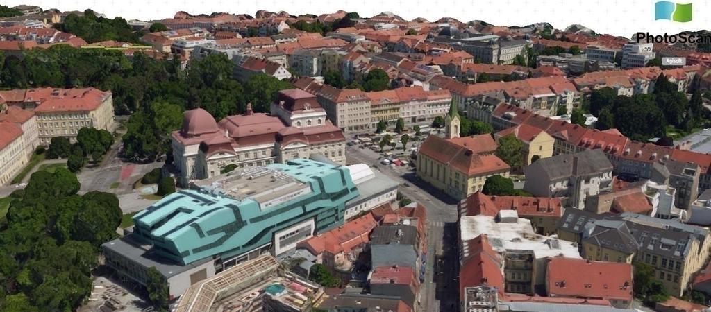
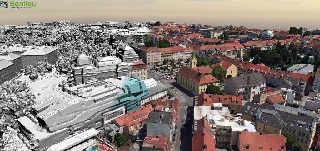
6 1.6. Results 6
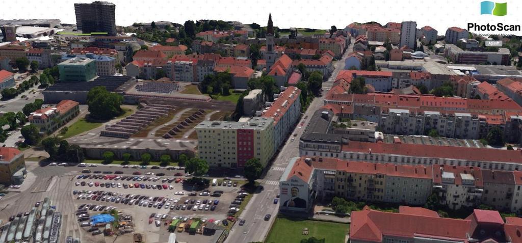
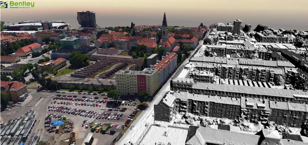
7 7

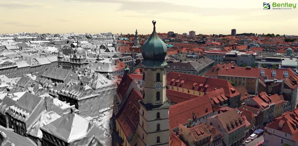
8 8
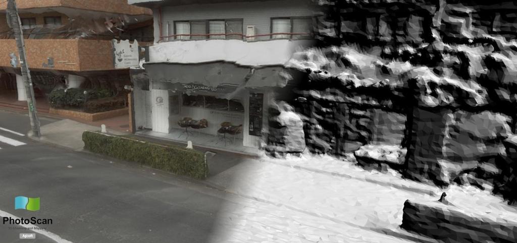
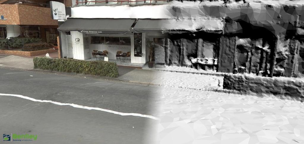
9 2- Application 2: Buildings - Fleurac 2.1. Computation System OS : windows 7 professional Processor : Intel core I7-4930k 3.40 GHz (8 processors / 16 threads) RAM : 64 Go GPU : Nvidia GeForce GTX Dataset The dataset is composed of 90 pictures looking at a castle in Fleurac (Dordogne, ). The pictures are set circularly around the scene and were shot from an aircraft. We have camera position information in the EXIF files for each images. Camera: Nikon D800 Pictures dimensions : 4858x3242 Focal length : for 68/90 images, focal length is 105mm for 22/90 images, focal length is 195mm Sensor size : 36 mm format: JPG 2.3. Preliminary remarks The input data size is 787Mo. This example can be considered as a reference for the following applications: Building modeling Cultural Heritage Infrastructures 9
10 2.4. Aerotriangulation Smart 3D Capture Pix4D Agisoft Photoscan Pictures aligned 90/90 90/90 90/90 Max RAM used 0.47 Go 1.10 Go 1.2 Go Computation time 9min 56sec 16min 59sec 5m36sec 2.5. Reconstruction Smart 3D Capture Pix4D Agisoft Photoscan Max RAM used 9.3 Go 3.8 Go 16.6 Go Computation time 2h 19min 5h 08min 6h 22min Number of triangles Size of generated file 105 Mo 665 Mo 376 Mo 10

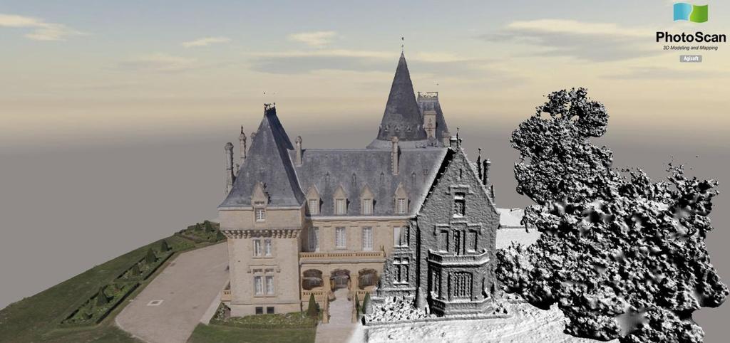
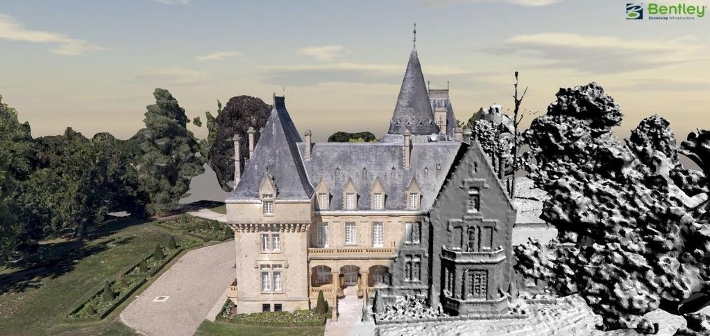
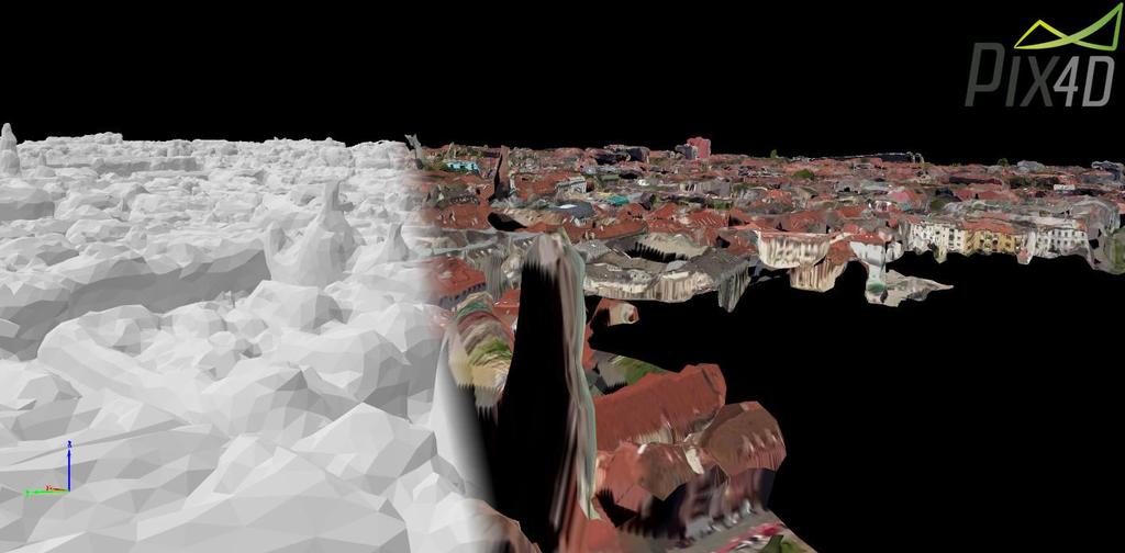
11 2.6. Results 11
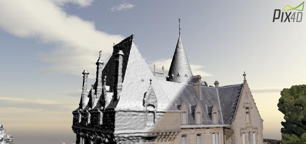
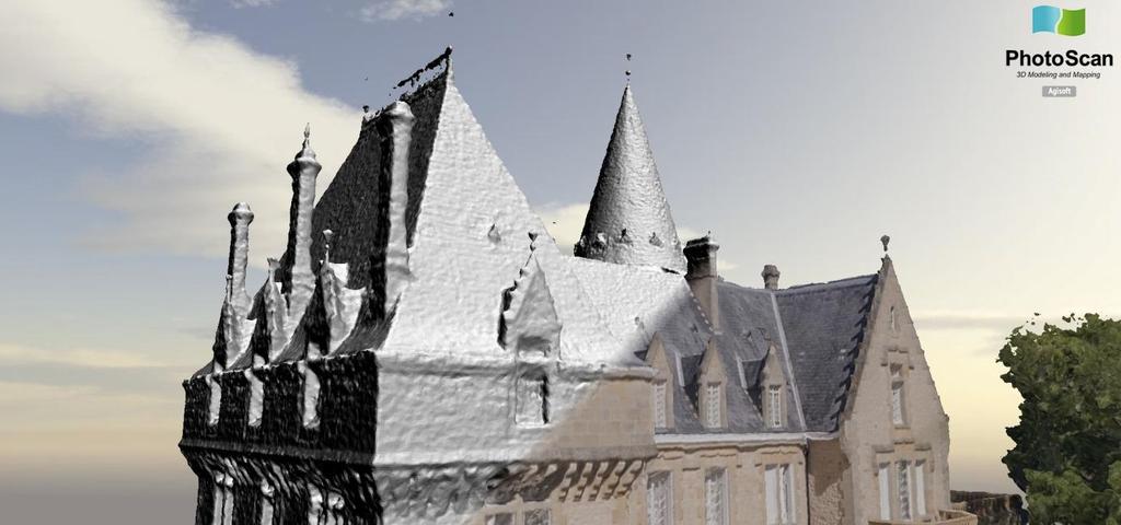
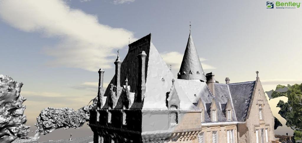
12 12
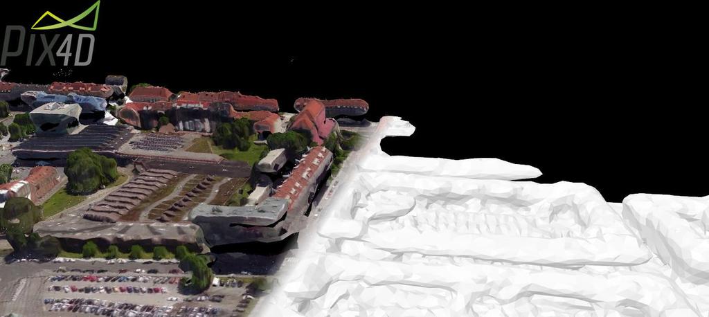
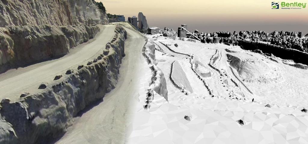
13 3- Application 3: Mining Quarry 3.1. Computation System OS : windows 7 professional Processor : Intel core I7-4930k 3.40 GHz (8 processors / 16 threads) RAM : 64 Go GPU : Nvidia GeForce GTX Dataset The dataset is composed of 127 nadir photos over a quarry. The photos were shot from an UAV. Camera position information is available in the EXIF files and 7 Ground Control points for this site. Camera: Canon IXUS220HS Pictures dimensions : 4000*3000 Focal length : 4.4 mm Sensor size : 6.2 x 4.65 mm Format: JPG 7 ground control points (WGS84) 3.3. Preliminary remarks The input data size is 450Mo. This case can be considered as a reference for the following applications: Land Surveying Mining Volume workouts Worksite management 13
14 3.4. Aerotriangulation Smart 3D Capture Pix4D Agisoft Photoscan Pictures aligned 127/ / /127 Max RAM used 0.37 Go 1.06 Go 1.3 Go Computation time 6min 13sec 6min 32sec 12 min 10s 3.5. Reconstruction Smart 3D Capture Pix4D Agisoft Photoscan Max RAM used 8.35 Go 4.08 Go 30 Go Computation time 1h 47min 0h 26min 2h 04min Number of triangles Size of generated file 123Mo 135 Mo 594 Mo 14

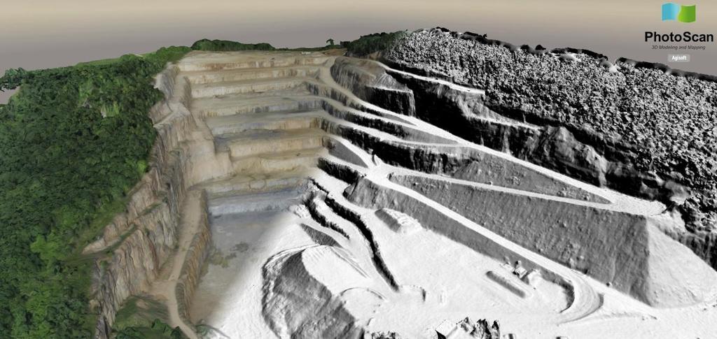
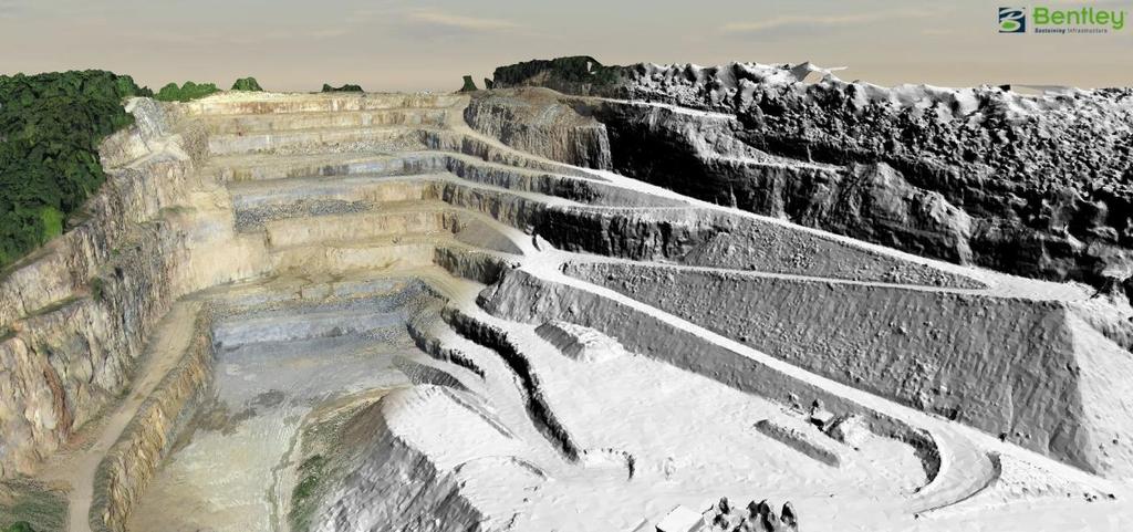
15 3.6. Results 15
16 16
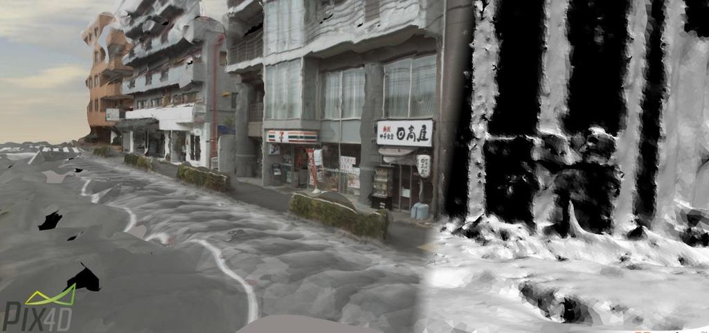
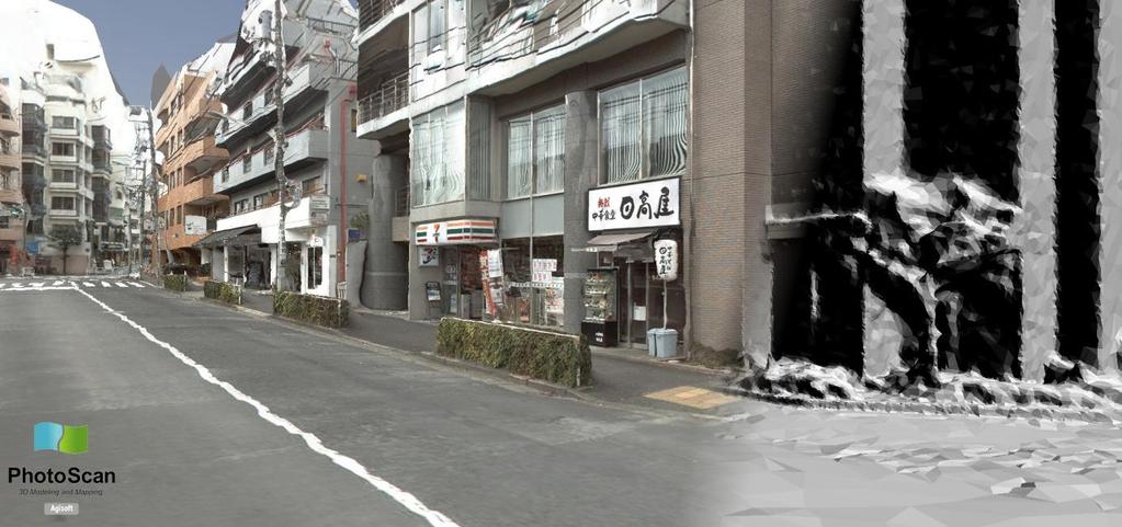
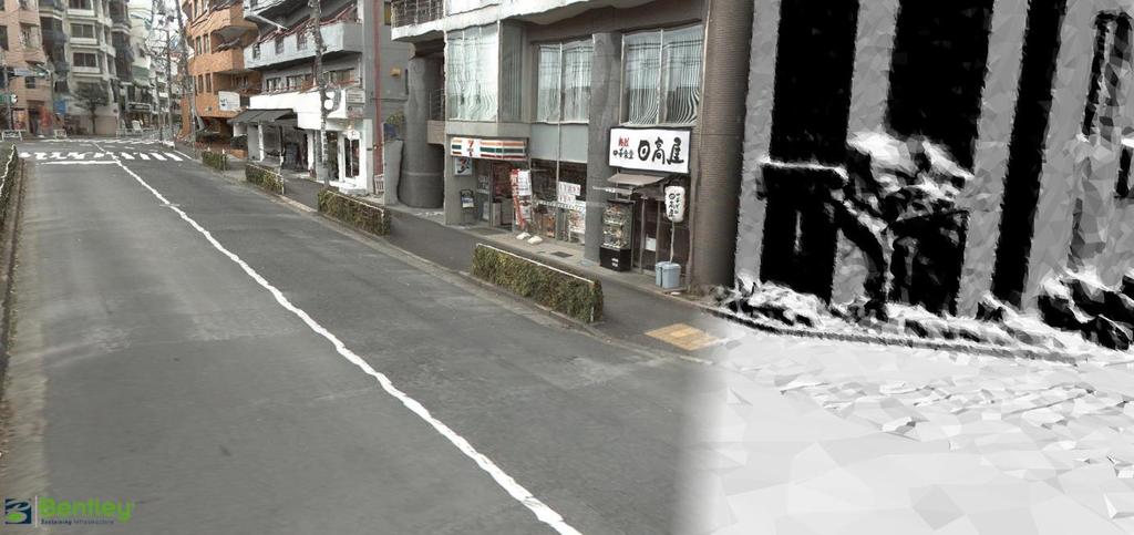
17 4- Application 4: Street - Tokyo 4.1. Computation System OS : windows 7 professional Processor : Intel core I7-4930k 3.40 GHz (8 processors / 16 threads) RAM : 64 Go GPU : Nvidia GeForce GTX Dataset The dataset is composed of 250 pictures shot from a car and looking around a street in Tokyo Camera: Point Grey Research Ladybug Pictures dimensions : 1232x1616 Focal length : 3.3 mm Sensor size : 7.11 mm format: JPG 4.3. Preliminary remarks The input data size is 128Mo. This case can be considered as a reference for the following applications: Street Modeling 3D mobile mapping 17
18 4.4. Aerotriangulation Smart 3D Capture Pix4D Agisoft Photoscan Pictures aligned 241/ / /250 Max RAM used 0.22 Go Go Computation time 6min 53sec 9min 33sec 32 min 12sec 4.5. Reconstruction Smart 3D Capture Pix4D Agisoft Photoscan Max RAM used 2.17 Go 2.29 Go 3.1 Go Computation time 42min 27sec 18 min 37 sec 38 min 23sec Number of triangles Size of generated file 47.8Mo 129 Mo 109 Mo 18

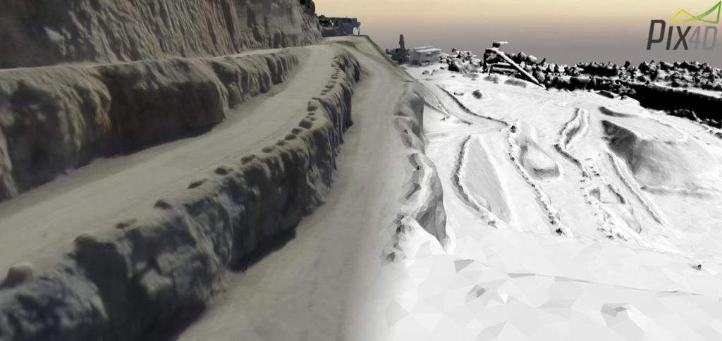
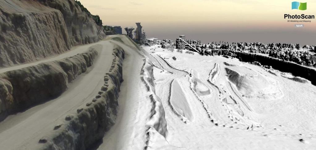
19 4.6. Results 19
20 20
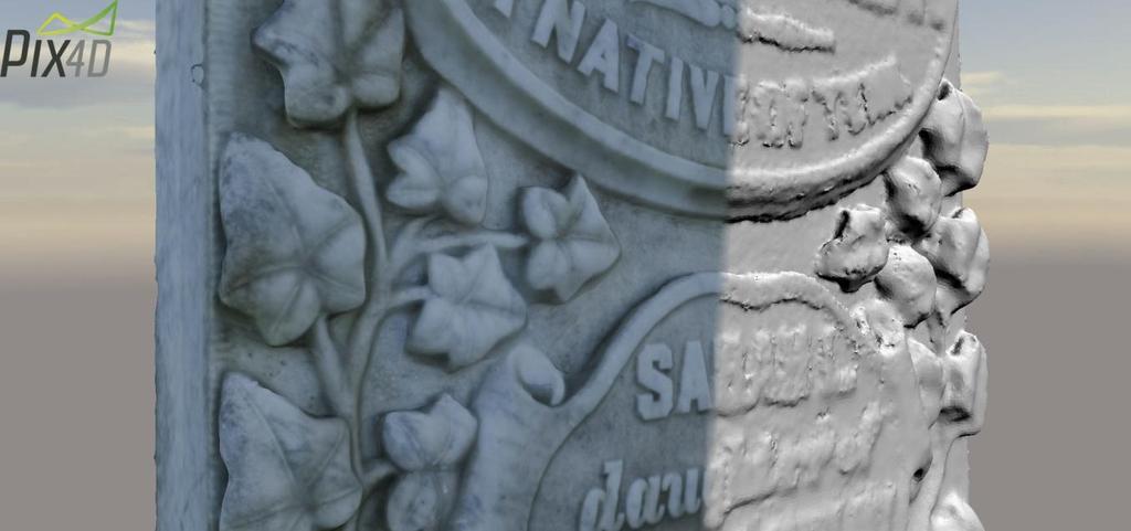
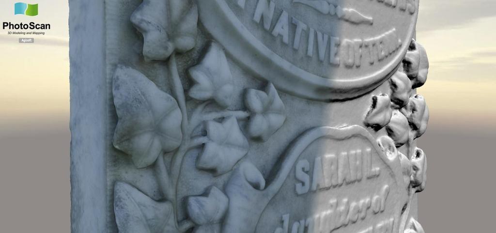
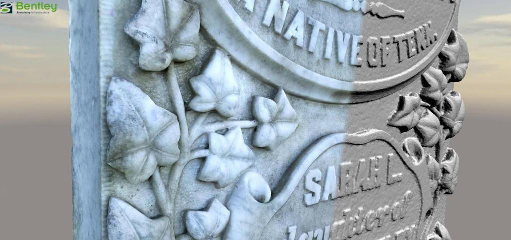
21 5- Application 5: Tombstone 5.1. Computation System OS : windows 7 professional Processor : Intel core I7-4930k 3.40 GHz (8 processors / 16 threads) RAM : 64 Go GPU : Nvidia GeForce GTX Dataset The dataset is composed of 89 terrestrial pictures shot looking around a tombstone in a cemetery Camera: Canon EOS 30D Pictures dimensions : 2336x3504 Focal length : 50 mm Sensor size : 22.5 mm format: TIF 5.3. Preliminary remarks The input data size is 2.09Go. This case can be considered as a reference for the following applications: - Cultural heritage - Archeology 21
22 5.4. Aerotriangulation Smart 3D Capture Pix4D Agisoft Photoscan Pictures aligned 79/89 84/89 89/89 Max RAM used 0.25 Go 0.54 Go 1.20 Go Computation time 3min 50sec 4min 24sec 4min 28sec 5.5. Reconstruction Smart 3D Capture Pix4D Agisoft Photoscan Max RAM used 3.75 Go 2.29 Go 10.1 Go Computation time 36min 20sec 12 min 01 sec 1h 02min 00sec Number of triangles Size of generated file 50.3 Mo 129 Mo 200 Mo 22

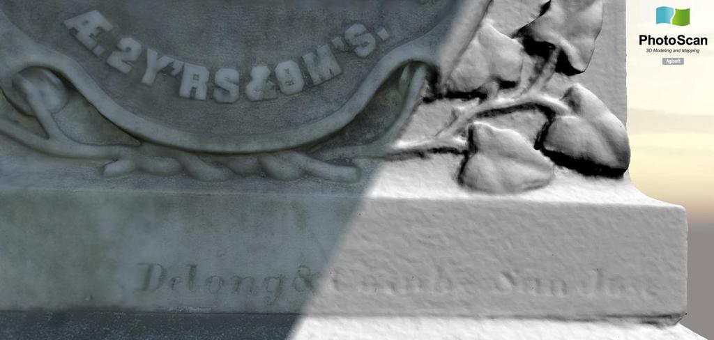
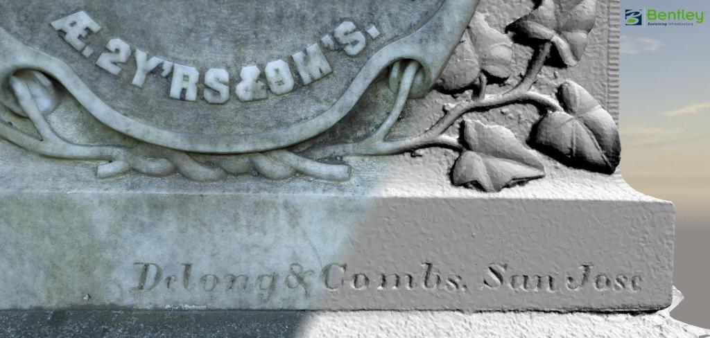
23 5.6. Results 23
24 24
25 6- Synthesis 6.1. Pix4d Advantages - Fast computation steps. The use of GPU in step 1 is really time saving (around 55% with a GTX980 for our tests). - The quality reports are really complete and give a good idea on how a process worked. - Even if they do not appear in this benchmark, the point-classification features (automatic classification and pointcloud edition) are interesting to extract some relevant parts of the model (Buildings, DTM,...). - The volume, perimeter and distance measurement tools are quite efficient and easy to use. Interoperability between these tools and Topography/GIS software looks quite efficient. - The user interface is intuitive, mainly for importing GCP or position/orientation info. Their automatic-pointing tool is really interesting and time-saving. - Pix4D provides an easy-to-use animation tool which allows the user to export videos from his work - The ability to automatically split a large georeferenced dataset is quite interesting and allows to deal with big data for initial processing (Aerotriangulation). - The licensing system is really efficient. The possibility to work on field with a portable license is interesting Drawbacks - The production of 3D-textured mesh is a new feature and it's not efficient yet. The number of triangles and texture size are defined-by-user parameters and they can't be automatically adjusted according to your model size or to your point cloud density. - The edges of the 3D-mesh are not as sharp as they can be in Smart3DCapture. Some small details cannot be reconstructed even with higher settings (See the Tombstone example). - Even if you can split your project in several parts and run them on separate machines, Pix4D doesn't' have real network computing feature. There is no way to run a same project on different engines from a unique computer. - A process (AT or point cloud densification) automatically overwrites your previous work. If you run an AT over an already aerotriangulated dataset, your first result is automatically lost. It forces you to save your work as a new project every time you reset your AT or dense point cloud computation if you want to keep intermediate results. - Impossibility to automatically use masks in order to hide some irrelevant parts of images. The annotation tool allows to discard some part of images during reconstruction step but you must do it manually by selecting these irrelevant areas in each photos. - No way to import Image-Path when importing a geolocation file. Which means you can't work on pictures with the same name but contained in different folders. - No way to import your whole data (images, cameras and GCP) in a single block-file. - The size of input pictures is limited to 42MP in the rental edition and you need to ask for an upgrade if you want to work with that kind of images. That's not mentioned when you purchase your PRO License. 25
26 6.2. Agisoft Photoscan Advantages - The tool for mask creation is really convenient. - Almost all the processing steps are parallelizable (Keypoint detection, photo matching, dense point cloud, tile export), meaning all the processing steps can be fasten using several computers. - Alignment between chunks: if a dataset has to be split in several chunks because of memory limitation, Photoscan is able to adjust the different chunks to get a seamless model at the junction. - Classification tool: the classification tool allows to remove quite efficiently all the building and vegetation in order to create a true DTM. - Volume calculation: Photoscan has a tool to calculate volume. Anyway, the process to do this calculation is not really convenient and not really flexible. You cannot specify a special/custom reference surface. - Orthophotos can be generated along different axis (not only Z) Drawbacks - The RAM consumption at all steps of the process is really important. This means you will need much more RAM than Smart3DCapture too process similar size projects. - 3D geometry not as sharp and detailed as Acute's. The building edges and small details are not as good. the model seems to be smoothed. - Photogroup and camera calibration per photogroup is tedious to setup (quite painful for multi-cameras systems). - After importing the metadata, there is no visual confirmation of the orientation of the cameras. - No smart bounding box setup (from 3D polygon for example, only manual) - The tiled 3D mesh export (.tls) is created from the dense point cloud and only convertible in LodTree format. To get OBJ, you will have to export the mesh again, and you will face memory crash for large project. - No touchup process for large tiled production - Impossible to process a large area in standard 3D format (as OBJ). - Creates very large 3D models with huge amount of triangles. - No link between the tile export and the standard 3D model export (Smart3DCapture has the "reference 3D model") - Tile export is handle as one "job", so if it fails, the export is lost and has to be started from scratch again. 26
Tutorial (Beginner level): Orthomosaic and DEM Generation with Agisoft PhotoScan Pro 1.3 (without Ground Control Points)
: Orthomosaic and DEM Generation with Agisoft PhotoScan Pro 1.3 (without Ground Control Points)") Tutorial (Beginner level): Orthomosaic and DEM Generation with Agisoft PhotoScan Pro 1.3 (without Ground Control Points) Overview Agisoft PhotoScan Professional allows to generate georeferenced dense point
Tutorial (Beginner level): Orthomosaic and DEM Generation with Agisoft PhotoScan Pro 1.3 (without Ground Control Points) Overview Agisoft PhotoScan Professional allows to generate georeferenced dense point
Tutorial (Beginner level): Orthomosaic and DEM Generation with Agisoft PhotoScan Pro 1.3 (with Ground Control Points)
: Orthomosaic and DEM Generation with Agisoft PhotoScan Pro 1.3 (with Ground Control Points)") Tutorial (Beginner level): Orthomosaic and DEM Generation with Agisoft PhotoScan Pro 1.3 (with Ground Control Points) Overview Agisoft PhotoScan Professional allows to generate georeferenced dense point
Tutorial (Beginner level): Orthomosaic and DEM Generation with Agisoft PhotoScan Pro 1.3 (with Ground Control Points) Overview Agisoft PhotoScan Professional allows to generate georeferenced dense point
Intelligent photogrammetry. Agisoft
 Intelligent photogrammetry Agisoft Agisoft Metashape is a cutting edge software solution, with its engine core driving photogrammetry to its ultimate limits, while the whole system is designed to deliver
PhotoScan. Fully automated professional photogrammetric kit
 PhotoScan Fully automated professional photogrammetric kit Agisoft PhotoScan is a stand-alone photogrammetric software solution for automatic generation of dense point clouds, textured polygonal models,
Quality Report Generated with Pro version
 Quality Report Generated with Pro version 2.1.61 Important: Click on the different icons for: Help to analyze the results in the Quality Report Additional information about the sections Click here for
Processed :36:54 Average Ground Sampling Distance (GSD) Time for Initial Processing (without report)
 Time for Initial Processing (without report)") Important: Click on the different icons for: Dronedata Back Office Server Generated Quality Report Phase 1 Time 07h:33m:02s Phase 2 Time 02h:58m:08s Phase 3 Time Not Applicable Total Time All Phases 10h:31m:08s
Important: Click on the different icons for: Dronedata Back Office Server Generated Quality Report Phase 1 Time 07h:33m:02s Phase 2 Time 02h:58m:08s Phase 3 Time Not Applicable Total Time All Phases 10h:31m:08s
Tutorial (Intermediate level): Dense Cloud Classification and DTM generation with Agisoft PhotoScan Pro 1.1
: Dense Cloud Classification and DTM generation with Agisoft PhotoScan Pro 1.1") Tutorial (Intermediate level): Dense Cloud Classification and DTM generation with Agisoft PhotoScan Pro 1.1 This tutorial illustrates how to perform dense point cloud classification in manual and automatic
Tutorial (Intermediate level): Dense Cloud Classification and DTM generation with Agisoft PhotoScan Pro 1.1 This tutorial illustrates how to perform dense point cloud classification in manual and automatic
PhotoScan. Fully automated professional photogrammetric kit
 PhotoScan Fully automated professional photogrammetric kit Agisoft PhotoScan is a stand-alone photogrammetric software solution for automatic generation of dense point clouds, textured polygonal models,
Quality Report Generated with Postflight Terra 3D version
 Quality Report Generated with Postflight Terra 3D version 4.0.89 Important: Click on the different icons for: Help to analyze the results in the Quality Report Additional information about the sections
Dataset2: Fleurac. Contents. Using a dataset containing geo-tags Getting familiar with spatial reference systems Advanced features
 Dataset2: Fleurac Using a dataset containing geo-tags Getting familiar with spatial reference systems Advanced features Contents 1. Creating a new project... 2 2. Importing your data... 3 3. Checking the
Quality Report Generated with Pix4Dmapper Pro version
 Quality Report Generated with Pix4Dmapper Pro version 3.2.23 Important: Click on the different icons for: Help to analyze the results in the Quality Report Additional information about the sections Click
28 out of 28 images calibrated (100%), all images enabled. 0.02% relative difference between initial and optimized internal camera parameters
, all images enabled. 0.02% relative difference between initial and optimized internal camera parameters") Dronedata Render Server Generated Quality Report Phase 1 Time 00h:01m:56s Phase 2 Time 00h:04m:35s Phase 3 Time 00h:13m:45s Total Time All Phases 00h:20m:16s Generated with Pix4Dmapper Pro - TRIAL version
Dronedata Render Server Generated Quality Report Phase 1 Time 00h:01m:56s Phase 2 Time 00h:04m:35s Phase 3 Time 00h:13m:45s Total Time All Phases 00h:20m:16s Generated with Pix4Dmapper Pro - TRIAL version
ADVANCING REALITY MODELING WITH CONTEXTCAPTURE
 ADVANCING REALITY MODELING WITH CONTEXTCAPTURE Knowing the existing conditions of a project is a key asset in any decision process. Governments need to better know their territories, through mapping operations,
Quality Report Generated with Pro version
 Quality Report Generated with Pro version 2.2.22 Important: Click on the different icons for: Help to analyze the results in the Quality Report Additional information about the sections Click here for
Near-Infrared Dataset. 101 out of 101 images calibrated (100%), all images enabled
, all images enabled") Dronedata Back Office Server Generated Quality Report Phase 1 Time 01h:22m:16s Phase 2 Time 00h:11m:39s Phase 3 Time 00h:01m:40s Total Time All Phases 01:35m:35s Generated with Pix4Dmapper Pro - TRIAL
Dronedata Back Office Server Generated Quality Report Phase 1 Time 01h:22m:16s Phase 2 Time 00h:11m:39s Phase 3 Time 00h:01m:40s Total Time All Phases 01:35m:35s Generated with Pix4Dmapper Pro - TRIAL
Paris-Le Bourget Airport. 557 out of 557 images calibrated (100%), all images enabled
, all images enabled") DroneData Render Server Generated Quality Report Phase 1 Time 00h:27m:34s Phase 2 Time 01h:40m:23s Phase 3 Time 01h:41m:18s Total Time All Phases 03h:48m:59s Generated with Pix4Dmapper Pro - TRIAL version
DroneData Render Server Generated Quality Report Phase 1 Time 00h:27m:34s Phase 2 Time 01h:40m:23s Phase 3 Time 01h:41m:18s Total Time All Phases 03h:48m:59s Generated with Pix4Dmapper Pro - TRIAL version
Quality Report Generated with Pix4Dmapper Pro version
 Quality Report Generated with Pix4Dmapper Pro version 3.1.23 Important: Click on the different icons for: Help to analyze the results in the Quality Report Additional information about the sections Click
Reality Modeling Drone Capture Guide
 Reality Modeling Drone Capture Guide Discover the best practices for photo acquisition-leveraging drones to create 3D reality models with ContextCapture, Bentley s reality modeling software. Learn the
Laptop Generated Quality Report Phase 1 Time 00h:26m:45s Phase 2 Time 02h:30m:06s Phase 3 Time 01h:20m:19s Total Time All phases 04h:17m:10s
 Laptop Generated Quality Report Phase 1 Time 00h:26m:45s Phase 2 Time 02h:30m:06s Phase 3 Time 01h:20m:19s Total Time All phases 04h:17m:10s Generated with Pix4Dmapper Pro - TRIAL version 2.0.104 Important:
Getting Started with Pix4D for Agriculture 3.3
 Getting Started with Pix4D for Agriculture 3.3 Sign-up 3 Redeem 4 Hardware - Computer 4 Software Download and Installation 5 Download 5 Installation 5 Update 8 Hardware - Cameras 8 Inputs 9 Outputs 9 Image
Drone2Map: an Introduction. October 2017
 Drone2Map: an Introduction October 2017 Drone2Map: An Introduction Topics: - Introduction to Drone Mapping - Coordinate Systems - Overview of Drone2Map - Basic Drone2Map Workflow - 2D Data Processing -
Quality Report Generated with version
 Quality Report Generated with version 3.3.67 Important: Click on the different icons for: Help to analyze the results in the Quality Report Additional information about the feature Click here for additional
Automated Processing for 3D Mosaic Generation, a Change of Paradigm
 Automated Processing for 3D Mosaic Generation, a Change of Paradigm Frank BIGNONE, Japan Key Words: 3D Urban Model, Street Imagery, Oblique imagery, Mobile Mapping System, Parallel processing, Digital
Support for external aerotriangulation results from professional systems (Inpho, Bingo).
.") PhotoMesh v7.2 PhotoMesh v7.2 fully automates the generation of high-resolution, textured, 3D mesh models from standard 2D photographs, offering a significant reduction in cost and time compared to traditional
PhotoMesh v7.2 PhotoMesh v7.2 fully automates the generation of high-resolution, textured, 3D mesh models from standard 2D photographs, offering a significant reduction in cost and time compared to traditional
Tutorial (Intermediate level): 3D Model Reconstruction of the building with Agisoft PhotoScan 1.0.0
: 3D Model Reconstruction of the building with Agisoft PhotoScan 1.0.0") Tutorial (Intermediate level): 3D Model Reconstruction of the building with Agisoft PhotoScan 1.0.0 Add Photos To add photos select Add Photos... command from the Workflow menu or click Add Photos button
Tutorial (Intermediate level): 3D Model Reconstruction of the building with Agisoft PhotoScan 1.0.0 Add Photos To add photos select Add Photos... command from the Workflow menu or click Add Photos button
Sasanka Madawalagama Geoinformatics Center Asian Institute of Technology Thailand
 Sasanka Madawalagama Geoinformatics Center Asian Institute of Technology Thailand This learning material was not prepared by ADB. The views expressed in this document are the views of the author/s and
Quality Report Generated with version
 Quality Report Generated with version 1.3.54 Important: Click on the different icons for: Help to analyze the results in the Quality Report Additional information about the feature Click here for additional
A Guide to Processing Photos into 3D Models Using Agisoft PhotoScan
 A Guide to Processing Photos into 3D Models Using Agisoft PhotoScan Samantha T. Porter University of Minnesota, Twin Cities Fall 2015 Index 1) Automatically masking a black background / Importing Images.
Comparing Aerial Photogrammetry and 3D Laser Scanning Methods for Creating 3D Models of Complex Objects
 Comparing Aerial Photogrammetry and 3D Laser Scanning Methods for Creating 3D Models of Complex Objects A Bentley Systems White Paper Cyril Novel Senior Software Engineer, Bentley Systems Renaud Keriven
Comparing Aerial Photogrammetry and 3D Laser Scanning Methods for Creating 3D Models of Complex Objects
 www.bentley.com Comparing Aerial Photogrammetry and 3D Laser Scanning Methods for Creating 3D Models of Complex Objects A Bentley White Paper Cyril Novel Senior Software Engineer, Bentley Systems Renaud
Agisoft PhotoScan Change Log
 Version 1.1.0 build 1976 (20 September 2014, preview Added support for camera groups: camera folders and camera stations. Added Export Panorama command. Added Thin Point Cloud command. Added Disabled depth
Vexcel Imaging Ve V x e c x el e I l maging I G maging mbh www. wwwv. e v x e c x e c l e -limaging. - c imaging. om c
 Vexcel Imaging History 2016 MBO: becomes a privately owned company again 2006 Vexcel Imaging acquired by Microsoft Corp., Redmond/USA 2003 1992 1985 Merger of Vexcel Corp. & Vexcel Imaging 1 st Digital
Agisoft PhotoScan User Manual. Professional Edition, Version 1.2
 Agisoft PhotoScan User Manual Professional Edition, Version 1.2 Agisoft PhotoScan User Manual: Professional Edition, Version 1.2 Publication date 2016 Copyright 2016 Agisoft LLC Table of Contents Overview...
Simply powerful. Pix4Dmapper features the raycloud. Read more on Next generation aerial image processing software
 Next generation aerial image processing software Simply powerful Pix4D is your solution to convert thousands of aerial images taken by lightweight UAV or aircraft into georeferenced 2D mosaics and 3D surface
Agisoft PhotoScan User Manual. Standard Edition, Version 1.0
 Agisoft PhotoScan User Manual Standard Edition, Version 1.0 Agisoft PhotoScan User Manual: Standard Edition, Version 1.0 Publication date 2014 Copyright 2014 Agisoft LLC Table of Contents Overview... iv
Structure from Motion (SfM) Photogrammetry Data Exploration and Processing Manual
 Photogrammetry Data Exploration and Processing Manual") Structure from Motion (SfM) Photogrammetry Data Exploration and Processing Manual Written by Katherine Shervais (UNAVCO) and James Dietrich (Dartmouth) Collecting data in the field is only the first step
Structure from Motion (SfM) Photogrammetry Data Exploration and Processing Manual Written by Katherine Shervais (UNAVCO) and James Dietrich (Dartmouth) Collecting data in the field is only the first step
Quality Report Generated with Pix4Ddiscovery version
 Quality Report Generated with Pix4Ddiscovery version 3.1.22 Important: Click on the different icons for: Help to analyze the results in the Quality Report Additional information about the sections Click
Processing to Create a 3D Model
 3D Modelling Processing to Create a 3D Model These guidance notes take you through how to process multiple photographs of a rock art panel to create a 3D model. In order to do this, you first need to capture
Assessing 3D Point Cloud Fidelity of UAS SfM Software Solutions Over Varying Terrain
 Assessing 3D Point Cloud Fidelity of UAS SfM Software Solutions Over Varying Terrain Michael Schwind, Michael J. Starek (Presenter) 18th Annual JALBTCX Airborne Coastal Mapping and Charting Technical Workshop,
PhotoMesh v7.0. What s New in PhotoMesh v7.0
 PhotoMesh v7.0 PhotoMesh v7.0 fully automates the generation of high-resolution, textured, 3D mesh models from standard 2D photographs. Combining any number of photographs, in a wide range of formats and
HYDRA FUSION TOOLS CAPABILITIES GUIDE REAL-TIME 3D RECONSTRUCTIONS
 HYDRA FUSION TOOLS CAPABILITIES GUIDE REAL-TIME 3D RECONSTRUCTIONS HYDRA FUSION TOOLS BUILDING A MAPPING SYSTEM Flying an unmanned aircraft system (UAS) is no longer a stand-alone activity. Operators are
Digital Photogrammetry Software Comparison for Rock Mass Characterization
 ARMA 18 1211 Digital Photogrammetry Software Comparison for Rock Mass Characterization Becker, R.E., Galayda, L.J., MacLaughlin, M.M. Montana Tech, Butte, Montana, USA Copyright 2018 ARMA, American Rock
Agisoft PhotoScan User Manual
 Agisoft PhotoScan User Manual Professional Edition, Version 1 SYNERGY POSITIONING SYSTEMS 3/52 Arrenway Drive, Albany Auckland, New Zealand Free Call: 0800-867-266 Phone: +64-9-476-5151 Fax: +64-9-476-5140
Multiview Photogrammetry 3D Virtual Geology for everyone
 Multiview Photogrammetry 3D Virtual Geology for everyone A short course Marko Vrabec University of Ljubljana, Department of Geology FIRST: some background info Precarious structural measurements of fractures
Quality assessment of DIM on oblique images (preliminary results)
") FACULTY OF GEODESY AND CARTOGRAPHY W A R S A W U N I V E R S I T Y O F T E C H N O L O G Y Quality assessment of DIM on oblique images (preliminary results) Wojciech Ostrowski, Krzysztof Bakuła, Zdzisław
FACULTY OF GEODESY AND CARTOGRAPHY W A R S A W U N I V E R S I T Y O F T E C H N O L O G Y Quality assessment of DIM on oblique images (preliminary results) Wojciech Ostrowski, Krzysztof Bakuła, Zdzisław
A New Protocol of CSI For The Royal Canadian Mounted Police
 A New Protocol of CSI For The Royal Canadian Mounted Police I. Introduction The Royal Canadian Mounted Police started using Unmanned Aerial Vehicles to help them with their work on collision and crime
STATUS OF AIRBORNE OBLIQUE IMAGING EUROSDR COMMISSION I PROJECT OBLIQUE IMAGERY. Markus Gerke May 15, 2014
 STATUS OF AIRBORNE OBLIQUE IMAGING EUROSDR COMMISSION I PROJECT OBLIQUE IMAGERY Markus Gerke May 15, 2014 THE FIRST AIRBORNE PHOTOS WERE OBLIQUE First recorded aerial photograph in the US (Boston), by
New! Analysis Ready Data Tools Add-on package for image preprocessing for multi-temporal analysis. Example of satellite imagery time series of Canada
 Highlights New! Analysis Ready Data Tools Add-on package for image preprocessing for multi-temporal analysis Rigorous scientific preprocessing Example of satellite imagery time series of Canada A new industry
RELEASE NOTES FOR PHOTOMESH 7.3
 RELEASE NOTES FOR PHOTOMESH 7.3 About PhotoMesh Skyline s PhotoMesh fully automates the generation of high-resolution, textured, 3D mesh models from standard 2D photographs, offering a significant reduction
ROAD-SCANNER COMPACT APPLICATION FIELDS MAIN FEATURES
 ROAD-SCANNER COMPACT Mobile Mapping System by GEXCEL & SITECO collaboration A smaller mobile system for asset management and cartography suited for ZOLLER & FRÖHLICH PROFILER 9012 laser scanner. 2 + 3
Hydra Fusion Tools. Capabilities Guide. Real-time 3D Reconstructions
 Hydra Fusion Tools Capabilities Guide Real-time 3D Reconstructions Hydra Fusion Tools Building a Mapping System Flying an unmanned aircraft system (UAS) is no longer a stand-alone activity. Operators are
Agisoft Photogrammetric Kit User Manual. Professional Edition, Version 1.3
 Agisoft Photogrammetric Kit User Manual Professional Edition, Version 1.3 Agisoft Photogrammetric Kit User Manual: Professional Edition, Version 1.3 Publication date 2017 Copyright 2017 Agisoft LLC Table
Open Pit Mines. Terrestrial LiDAR and UAV Aerial Triangulation for. Figure 1: ILRIS at work
 Terrestrial LiDAR and UAV Aerial Triangulation for Open Pit Mines Figure 1: ILRIS at work Figure 2: Geo-Copter X-8000 taking off ay what you will about the past few years, it has produced some useful tools
UAV s in Surveying: Integration/processes/deliverables A-Z. 3Dsurvey.si
 UAV s in Surveying: Integration/processes/deliverables A-Z Info@eGPS.net TODAY S PROGRAM Introduction to photogrammetry and 3Dsurvey Theoretical facts about the technology and basics of 3dsurvey Introduction
Surveying like never before
 CAD functionalities GCP Mapping and Aerial Image Processing Software for Land Surveying Specialists Surveying like never before www.3dsurvey.si Modri Planet d.o.o., Distributors: info@3dsurvey.si +386
SimActive and PhaseOne Workflow case study. By François Riendeau and Dr. Yuri Raizman Revision 1.0
 SimActive and PhaseOne Workflow case study By François Riendeau and Dr. Yuri Raizman Revision 1.0 Contents 1. Introduction... 2 1.1. Simactive... 2 1.2. PhaseOne Industrial... 2 2. Testing Procedure...
Drone2Map for ArcGIS: Bring Drone Imagery into ArcGIS. Will
 Drone2Map for ArcGIS: Bring Drone Imagery into ArcGIS Will Meyers @MeyersMaps A New Window on the World Personal Mapping for Micro-Geographies Accurate High Quality Simple Low-Cost Drone2Map for ArcGIS
3D recording of archaeological excavation
 5 th International Conference Remote Sensing in Archaeology The Age of Sensing 13-15 October 2014 - Duke University 3D recording of archaeological excavation Stefano Campana UNIVERSITY of CAMBRIDGE Faculty
Agisoft PhotoScan User Manual. Professional Edition, Version 1.4
 Agisoft PhotoScan User Manual Professional Edition, Version 1.4 Agisoft PhotoScan User Manual: Professional Edition, Version 1.4 Publication date 2018 Copyright 2018 Agisoft LLC Table of Contents Overview...
FOUR-BAND THERMAL MOSAICKING: A NEW METHOD TO PROCESS THERMAL IMAGERY FROM UAV FLIGHT YICHEN YANG YALE SCHOOL OF FORESTRY AND ENVIRONMENTAL STUDIES
 FOUR-BAND THERMAL MOSAICKING: A NEW METHOD TO PROCESS THERMAL IMAGERY FROM UAV FLIGHT YICHEN YANG YALE SCHOOL OF FORESTRY AND ENVIRONMENTAL STUDIES OUTLINE Background Objectives Methodology Results Calibration
2/9/2016. Session Agenda: Implementing new Geospatial Technologies for more efficient data capture
 Implementing new Geospatial Technologies for more efficient data capture Jay Haskamp Applied Geospatial Engineer Steve Richter VP Sales Session Agenda: Today s changing technologies and what lies ahead
Boresight alignment method for mobile laser scanning systems
 Boresight alignment method for mobile laser scanning systems P. Rieger, N. Studnicka, M. Pfennigbauer RIEGL Laser Measurement Systems GmbH A-3580 Horn, Austria Contents A new principle of boresight alignment
TRAINING MATERIAL HOW TO OPTIMIZE ACCURACY WITH CORRELATOR3D
 TRAINING MATERIAL WITH CORRELATOR3D Page2 Contents 1. UNDERSTANDING INPUT DATA REQUIREMENTS... 4 1.1 What is Aerial Triangulation?... 4 1.2 Recommended Flight Configuration... 4 1.3 Data Requirements for
ALL-IN-ONE DRONE SOLUTION FOR 3D MODELING
 ALL-IN-ONE DRONE SOLUTION FOR 3D MODELING Powered by PHOTO & VIDEO FULL HD 1080P - 14MPX 3-AXIS STABILIZATION AUGMENTED POWER 30MIN FLIGHT TIME 32GB INTERNAL MEMORY INCLUDES 3D MODELING SOFTWARE SAFE VIEW
Quality Accuracy Professionalism
 GeoWing - who are we? Mapping Data Service Provider Lidar Multispectral Topographic and Planimetric Maps Elevation Models Point Clouds / 3D Models Orthophotography FAA-Authorized UAS Operators WOSB / DBE
Mosaicking Software: A comparison of various software suites. Geosystems Research Institute Report 5071
 Mosaicking Software: A comparison of various software suites Geosystems Research Institute Report 5071 Lee Hathcock (Mississippi State University) Ryan MacNeille (Altavian, Inc.) 3-24-2016 Mosaicking software
Dynamic 3D representation of information using low cost Cloud ready Technologies
 National Technical University Of Athens School of Rural and Surveying Engineering Laboratory of Photogrammetry Dynamic 3D representation of information using low cost Cloud ready Technologies George MOURAFETIS,
Available online at ScienceDirect. Procedia Environmental Sciences 36 (2016 )
") Available online at www.sciencedirect.com ScienceDirect Procedia Environmental Sciences 36 (2016 ) 184 190 International Conference on Geographies of Health and Living in Cities: Making Cities Healthy
Available online at www.sciencedirect.com ScienceDirect Procedia Environmental Sciences 36 (2016 ) 184 190 International Conference on Geographies of Health and Living in Cities: Making Cities Healthy
2018 SimActive Inc. All rights reserved.
 2018 SimActive Inc. All rights reserved. Table of Contents 1. Important Notes... 5 2. Overview... 6 3. System Requirements... 7 4. Data Requirements... 8 4.1 Sensor Types... 8 4.2 Input Image Formats...
The Use of UAS in modern field work
 The Use of UAS in modern field work SplitRS 2015, Thessaloniki, GREECE 22/05/2015 1 ebee by sensefly Swiss-made UAV Fully autonomous flight Suitable for: Mapping, GIS, Surveying Precision Agriculture Environmental
Unmanned Aerial Systems: A Look Into UAS at ODOT
 Ohio Department of Transportation John R. Kasich, Governor Jerry Wray, Director Unmanned Aerial Systems: Tim Burkholder, PS Mapping Manager Division of Engineering Office of CADD and Mapping Services Kyle
UAS for Surveyors. An emerging technology for the Geospatial Industry. Ian Murgatroyd : Technical Sales Rep. Trimble
 UAS for Surveyors An emerging technology for the Geospatial Industry Ian Murgatroyd : Technical Sales Rep. Trimble Project Overview Voyager Quarry, located near Perth Australia Typical of hard rock mines,
Drone2Map for ArcGIS: Bring Drone Imagery into ArcGIS
 Drone2Map for ArcGIS: Bring Drone Imagery into ArcGIS Mike Sweeney 1 Drone2Map for ArcGIS Turn Drones into Enterprise Productivity Tools ArcGIS Drone2Map for ArcGIS Create 2D and 3D products from raw drone
2. POINT CLOUD DATA PROCESSING
 Point Cloud Generation from suas-mounted iphone Imagery: Performance Analysis A. D. Ladai, J. Miller Towill, Inc., 2300 Clayton Road, Suite 1200, Concord, CA 94520-2176, USA - (andras.ladai, jeffrey.miller)@towill.com
3D Laser Scanner VS1000 User Manual
 3D Laser Scanner VS1000 User Manual 1 VS1000 Introduction SMART MAX GEOSYSTEMS CO., LTD VS1000 3D Laser Scanner based on pulses ranging principle, could quick acquire massive point cloud data from the
Grafica 3D per i beni culturali: Dense stereo matching, alternative e processing finale del modello (+ extra) Lezione 14: 9 maggio 2013
 Lezione 14: 9 maggio 2013") Grafica 3D per i beni culturali: Dense stereo matching, alternative e processing finale del modello (+ extra) Lezione 14: 9 maggio 2013 0 Image-based 3D Reconstruction Advantages: Automatic Fast (relatively
Grafica 3D per i beni culturali: Dense stereo matching, alternative e processing finale del modello (+ extra) Lezione 14: 9 maggio 2013 0 Image-based 3D Reconstruction Advantages: Automatic Fast (relatively
Copyright 2013 by 3Dflow srl. All Rights Reserved.
 Copyright 2013 by 3Dflow srl. All Rights Reserved. Table of contents Introduction... 3 System Requirements... 3 Versions... 4 Activation... 4 Documentation... 4 A Quick Overview... 5 Photography Guide...
Photogrammetry for forest inventory.
 Photogrammetry for forest inventory. Marc Pierrot Deseilligny. IGN/ENSG, France. Jonathan Lisein. Ulg Gembloux Agro-Bio Tech, Belgium. 1- Photogrammetry 2- Application to forestry 3- Tools and proposed
QuickSpecs. HP Z 3D Camera. HP Z 3D Camera. Overview. 1. Main Module 2. Mount 3. Scan Mat
 1. Main Module 2. Mount 3. Scan Mat Page 1 1. Main Module 2. Mount 3. Scan Mat Side View dimensions Page 2 1. Main Module 2. Mount 3. Scan Mat Front view dimensions Page 3 1. Main Module 2. Mount 3. Scan
Surface and Terrain Models
 Advanced Matching Techniques for High Precision Surface and Terrain Models Introduction Comeback of image matching for DTM & DSM generation Very few professional tools for DSM generation from image matching
Scalability for Large Photogrammetry Projects
 Scalability for Large Photogrammetry Projects Dr. Philippe Simard President SimActive Inc. IMAGE About SimActive Founded in 2003, SimActive is the developer of Correlator3D software, a patented end-to-end
Agisoft PhotoScan User Manual. Standard Edition, Version 1.3
 Agisoft PhotoScan User Manual Standard Edition, Version 1.3 Agisoft PhotoScan User Manual: Standard Edition, Version 1.3 Publication date 2017 Copyright 2017 Agisoft LLC Table of Contents Overview... iv
AIRPHEN. The Multispectral camera from HIPHEN
 AIRPHEN The Multispectral camera from HIPHEN AIRPHEN is a multispectral scientific camera developed by agronomists and photonics engineers to match plant measurements needs and constraints. Its high flexibility,
THE ISPRS/EUROSDR BENCHMARK ON MULTI-PLATFORM PHOTOGRAMMETRY: RESULTS AND LESSON LEARNT FRANCESCO NEX AND MARKUS GERKE
 THE ISPRS/EUROSDR BENCHMARK ON MULTI-PLATFORM PHOTOGRAMMETRY: RESULTS AND LESSON LEARNT FRANCESCO NEX AND MARKUS GERKE Overview Summary of the results Statistics Data release What s next? ISPRS / EuroSDR
Blazer Pro V2.1 Client Requirements & Hardware Performance
 Blazer Pro V2.1 Client Requirements & Hardware Performance Table of Contents Chapter 1 Client Requirements... 2 Chapter 2 Control Client Performance... 3 2.1 Local Control Client on Blazer Pro Server...
NATIONWIDE POINT CLOUDS AND 3D GEO- INFORMATION: CREATION AND MAINTENANCE GEORGE VOSSELMAN
 NATIONWIDE POINT CLOUDS AND 3D GEO- INFORMATION: CREATION AND MAINTENANCE GEORGE VOSSELMAN OVERVIEW National point clouds Airborne laser scanning in the Netherlands Quality control Developments in lidar
Structure from Motion: High resolution DEMs at any scale using everyday equipment
 Structure from Motion: High resolution DEMs at any scale using everyday equipment Anders Damsgaard Last revision: May 20, 2014 Outline Photogrammetry Method Examples Summary Photogrammetry using SfM Production
Capturing Reality with Point Clouds: Applications, Challenges and Solutions
 Capturing Reality with Point Clouds: Applications, Challenges and Solutions Rico Richter 1 st February 2017 Oracle Spatial Summit at BIWA 2017 Hasso Plattner Institute Point Cloud Analytics and Visualization
Italian pavilion in 3D, project for EXPO 2015, Milan (Italy) JRC 3D RECONSTRUCTOR POWERFUL. ADVANCED. PROFESSIONAL
 JRC 3D RECONSTRUCTOR POWERFUL. ADVANCED. PROFESSIONAL") Italian pavilion in 3D, project for EXPO 2015, Milan (Italy) JRC 3D RECONSTRUCTOR POWERFUL. ADVANCED. PROFESSIONAL OVERVIEW JRC 3D Reconstructor is the well known multi-platform and multi-resolution software
Italian pavilion in 3D, project for EXPO 2015, Milan (Italy) JRC 3D RECONSTRUCTOR POWERFUL. ADVANCED. PROFESSIONAL OVERVIEW JRC 3D Reconstructor is the well known multi-platform and multi-resolution software
Lens Selection Software. User Manual
 Lens Selection Software User Manual User Manual COPYRIGHT 2017 Hangzhou Hikvision Digital Technology Co., Ltd. ALL RIGHTS RESERVED. Any and all information, including, among others, wordings, pictures,
Practical Considerations of UAS Operations on Data Quality
 Practical Considerations of UAS Operations on Data Quality Precision. Accuracy. Reliability OVERVIEW Project Planning and Execution Ground Control Data Processing and Delivery 1 OVERVIEW Get Legal: Section
Tutorial (Intermediate level): Marker based chunk alignment in Agisoft PhotoScan Pro 1.0.0
: Marker based chunk alignment in Agisoft PhotoScan Pro 1.0.0") Tutorial (Intermediate level): Marker based chunk alignment in Agisoft PhotoScan Pro 1.0.0 This tutorial shows how marker based chunk alignment can be used for referenced and unreferenced models. Overview
Tutorial (Intermediate level): Marker based chunk alignment in Agisoft PhotoScan Pro 1.0.0 This tutorial shows how marker based chunk alignment can be used for referenced and unreferenced models. Overview
Visualizing 2D Data in a 3D World
 Visualizing 2D Data in a 3D World Karl Kliparchuk, M.Sc., GISP, and Brendan Walashek, B.Sc. McElhanney Consulting Services Ltd. Email: kkliparchuk@mcelhanney.com and bwalashek@mcelhanney.com Agenda A Quick
Tutorial (Intermediate Level): Radiometric calibration using reflectance panels in PhotoScan Professional 1.4
: Radiometric calibration using reflectance panels in PhotoScan Professional 1.4") Tutorial (Intermediate Level): Radiometric calibration using reflectance panels in PhotoScan Professional 1.4 This tutorial describes common workflow related to the reflectance calibration of multispectral
Tutorial (Intermediate Level): Radiometric calibration using reflectance panels in PhotoScan Professional 1.4 This tutorial describes common workflow related to the reflectance calibration of multispectral
2-4 April 2019 Taets Art and Event Park, Amsterdam CLICK TO KNOW MORE
 Co-Host Host 2-4 April 2019 Taets Art and Event Park, Amsterdam CLICK TO KNOW MORE Presentation Outline review modern survey methodologies available to support railway requirements measuring everything
Grafica 3D per i beni culturali: Multiview stereo matching, the tools Maggio 2018
 Grafica 3D per i beni culturali: Multiview stereo matching, the tools 10-15 Maggio 2018 0 Image-based 3D Reconstruction Advantages: Automatic Fast (relatively to manual built) Good scalability (both small
STATE-OF-THE-ART in DENSE IMAGE MATCHING
 STATE-OF-THE-ART in DENSE IMAGE MATCHING Fabio REMONDINO 3D Optical Metrology (3DOM) Bruno Kessler Foundation (FBK) Trento, Italy Email: remondino@fbk.eu http://3dom.fbk.eu Bruno Kessler Foundation (FBK)
Photogrammetry and 3D city modelling
 Digital Architecture and Construction 209 Photogrammetry and 3D city modelling Y. Kobayashi School of Architecture and Landscape Architecture, Arizona State University, USA Abstract 3D city modelling and
Journal Online Jaringan COT POLIPD (JOJAPS) Accuracy Assessment of Height Coordinate Using Unmanned Aerial Vehicle Images Based On Leveling Height
 Accuracy Assessment of Height Coordinate Using Unmanned Aerial Vehicle Images Based On Leveling Height") JOJAPS eissn 2504-8457 Abstract Journal Online Jaringan COT POLIPD (JOJAPS) Accuracy Assessment of Height Coordinate Using Unmanned Aerial Vehicle Images Based On Leveling Height Syamsul Anuar Bin Abu
JOJAPS eissn 2504-8457 Abstract Journal Online Jaringan COT POLIPD (JOJAPS) Accuracy Assessment of Height Coordinate Using Unmanned Aerial Vehicle Images Based On Leveling Height Syamsul Anuar Bin Abu
2011 Bentley Systems, Incorporated. Bentley Descartes V8i (SELECTseries 3) Advancing Information Modeling For Intelligent Infrastructure
 Advancing Information Modeling For Intelligent Infrastructure") Bentley Descartes V8i (SELECTseries 3) Advancing Information Modeling For Intelligent Infrastructure What is Bentley Descartes? Image Processing Raster Geo-Referencing Advanced raster transformation (warping,
Bentley Descartes V8i (SELECTseries 3) Advancing Information Modeling For Intelligent Infrastructure What is Bentley Descartes? Image Processing Raster Geo-Referencing Advanced raster transformation (warping,