From Multi-sensor Data to 3D Reconstruction of Earth Surface: Innovative, Powerful Methods for Geoscience and Other Applications
|
|
|
- Scarlett Bradley
- 5 years ago
- Views:
Transcription
1 From Multi-sensor Data to 3D Reconstruction of Earth Surface: Innovative, Powerful Methods for Geoscience and Other Applications Bea Csatho, Toni Schenk*, Taehun Yoon* and Michael Sheridan, Department of Geology, UB, Buffalo, NY * Also with Dept. of CEEGS, The Ohio State University, Columbus, OH
2 Overview Goal Motivation UB-OSU surface reconstruction approach Applications Potential projects and collaborations 2/13/2008 CEIS University Technology Showcase 2
3 Goal The ultimate goal is to reconstruct, as automatically as possible, the 3D object space from multi-sensor, multi-source data, with respect to Geometry (position, dimension of objects) Radiometry (material properties of objects) Semantics (labeled objects) 2/13/2008 CEIS University Technology Showcase 3
4 Motivation Volume and diversity of remotely sensed data rapidly increases Increasing resolution: spatial, temporal and spectral resolution Different viewing i geometry: oblique, nadir Different Sensor types: line, frame, whiskbroom, panoramic cameras, conical laser scanner Different phenomenology: VIS, NIR, microwave, radar Negative effect: Analysis doesn t keep up with increasing data volume Positive effect: Multi-sensor data provides complimentary and redundant information and therefore supports automation 2/13/2008 CEIS University Technology Showcase 4
5
6 Why Multi-Sensor, Multi-Source Data The goal of automatically reconstructing a 3D scene is very difficult, it is a hard problem Sensors that record different and complementary properties (multi-sensor) contribute toward the solution Existing data and information (multi-source), such as GIS, maps of all kinds, must also be included, if appropriate 2/13/2008 CEIS University Technology Showcase 6
7 What we do Today, a Typical Solution from Geology All data are processed individually and stored and manipulated in a Geographic Information System Advantages: GIS can handle raster, vector and point data; GIS has advanced spatial queries and statistical tools; Disadvantages: Surface are 2 and 2.5 D not real 3D Data input to GIS requires extensive preprocessing p Correction of geometric errors is limited e.g., rubbersheeting or affine transformation Image layers are essentially orthophotographs see demo! 2/13/2008 CEIS University Technology Showcase 7


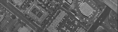
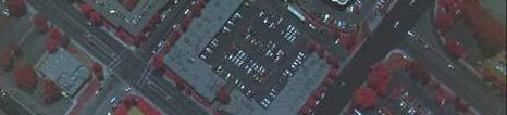
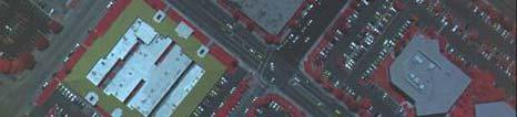
8 Example: Antarctic Dry Valleys GIS 2/13/2008 CEIS University Technology Showcase 8


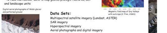
9 Task 1: Identify magnetic anomalies and ice flow pattern related to dolerites rock outcrops 400 GIS 20 km Relationship between ice flow and geology: Geologic map overlain on Landsat imagery Delineation of subsurface structures: Geologic map overlain on magnetic field map -150 nt


 LIDAR")
 Aerial")

10 Task 2: measure changes in glacier extent and thickness from multi-temporal terrestrial and aerial imagery and laser point cloud Terrestrial photographs h since 1905 (Scott s expedition) LIDAR measurements in 2001 (control information) Aerial photographs since the1950s GIS, photogrammetry workstations, LIDAR processing programs (e.g., QT Modeler)????
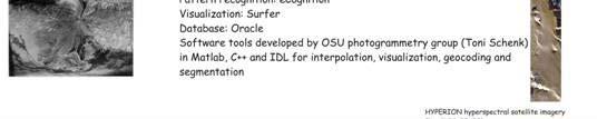
11 UB-OSU Surface Reconstruction System Step 1: Sensor Orientation An absolute prerequisite for fusing data from different sensors and different sources is establishing a common, well defined 3D orthogonal reference system. With many data acquisition systems equipped with GPS, a natural choice is the WGS-84 system, the default system for GPS positions Step 1: Feature-based, rigorous sensor orientation (alignment) by using point, linear and aerial features extracted from images, point clouds, GIS. The orientation is based on sensor modeling and errors are computed by error propagation. 2/13/2008 CEIS University Technology Showcase 11
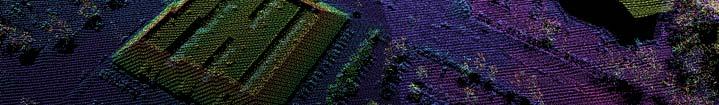
12 UB-OSU Surface Reconstruction System Step 2: Surface Reconstruction Surfaces in 3D object space play an important role for most applications. They can be generated from images, e.g. automatic matching of corresponding features, from LIDAR point clouds, from IfSAR, or from a combination of these methods. Surfaces are represented by regular grid structures (DEM) or by analytical functions that approximate surface patches Step 2. Matching and surface reconstruction in object space. Features are extracted, matched and fused on different levels of processing, e.g., from laser point clouds, DEMs, aerial and terrestrial images, classified hyperspectral data cube, etc. Registration is refined during surface reconstruction. Additional data, for example hyperspectral imagery or SAR, are ingested to identify surface materials. 2/13/2008 CEIS University Technology Showcase 12
13 UB-OSU Surface Reconstruction System Step 3: 3D Visualization, Measuring and Editing True 3D visualization greatly helps analysts to interpret 3D scenes. True 3D visualization of sensor data requires oriented sensors and the reconstructed surface. Step 3: True 3D visualization of multi-sensor data augmented by editing and measuring capabilities to fully exploit its potential. 2/13/2008 CEIS University Technology Showcase 13
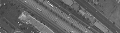
14 Feature-Based Orientation Analytical representations of linear and aerial features are used as control features and tie lines. No point to point correspondence is needed Suitable for multi-sensor data, for example images, point clouds and GIS Schenk, T., From point-based to feature- based aerial triangulation. ISPRS Journal of Photogrammetry and Remote Sensing 58, The six image patches show the area covered by six photographs. Superimposed are the edges as obtained with the Canny operator. Five edges that appear on all six images are manually selected as tie lines. These selected tie lines are numbered 1 to 5.


15 Feature-Based Block Adjustment: Orienting Images to 3D Point Cloud First operational system in the world -- See UB demo (Data from courtesy of M. Bevis, OSU)
 edges of the aerial stereopair obtained by the Canny operator. (3) More specific edges derived by domain knowledge.")

 and polyhedral surfaces organized at the")
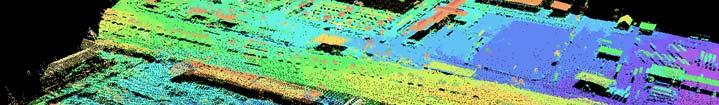
16 Surface Reconstruction, Geometry Fusing aerial images with LIDAR data in object space. From left to right: (1-2) edges of the aerial stereopair obtained by the Canny operator. (3) More specific edges derived by domain knowledge. These edges were matched in object space with the segmented LIDAR surface to obtain the final result (4). Colors of region boundaries: red: LIDAR+aerial+aerial;yellow: LIDAR+aerial; magenta: aerial+aerial; blue: LIDAR; green: aerial. (From Schenk, T. and B. Csatho, Fusion of LIDAR data and aerial imagery for a more complete surface reconstruction. ISPRS Archive 34(3A), ) Perceptual organization of a LIDAR point cloud. Left: 3D view of Delaunay triangulation; right: visualization of perceptually organized surfaces showing ground surface (green) and polyhedral surfaces organized at the structural level. Colors indicates grouping. g (From Lee, I. and T. Schenk, D perceptual organization of laser altimetry data. ISPRS Archive 34(3/W4), 57-65, and PhD Dissertation at OSU)
17 Surface Reconstruction, Surface Properties/Semantics Self-Organizing Map (SOM) based clustering of AVIRIS hyperspectral imagery, Ocean City, Maryland 4 m / pixel spatial resolution 40 x 40 SOM < 100,000 pixels 35 clusters Cluster map From Merenyi, E., B. Csatho and K. Tasdemir, Knowledge discovery in urban environments from fused multidimensional imagery. Proc. 4th IEEE GRSS/ISPRS Joint Workshop on Remote Sensing and Data Fusion over Urban Areas (URBAN 2007), Paris, France, April 11-13, (invited paper) 13 pp. IEEE Catalog number 07EX1577.


18 Application: Reconstruction of Long-term History of Greenland Outlet Glaciers from Historical Aerial Photographs and Satellite Imagery Csatho et al., Intermittent thinning of Jakobshavn Isbrae, west Greenland since the Little Ice Age. Journal of Glaciology, 54(184), and (
19 Potential Projects or Collaborations Develop a robust sensor orientation system ( toolbox ), based on sensor invariant features. Such a system must be user-friendly, robust, and easy to be used by non-specialists Develop a surface reconstruction system based on fusing different sensor data or surface information from different sources. Develop a surface representation scheme that is based on approximating surface patches by analytical functions, including the surface patch boundaries 2/13/2008 CEIS University Technology Showcase 19
20 Potential Projects or Collaborations Develop a true 3D visualization system augmented with the capabilities to interactively ti identify, move, and edit objects to measure and edit features to superimpose any data, features, information, or objects that are references to the common reference system 2/13/2008 CEIS University Technology Showcase 20


21 Demonstration of UB OSU Software Development Demonstration of UB-OSU Software Development and Visualization Environment at CEIS
BUILDING MODEL RECONSTRUCTION FROM DATA INTEGRATION INTRODUCTION
 BUILDING MODEL RECONSTRUCTION FROM DATA INTEGRATION Ruijin Ma Department Of Civil Engineering Technology SUNY-Alfred Alfred, NY 14802 mar@alfredstate.edu ABSTRACT Building model reconstruction has been
Spectral Interpretation Based on Multisensor Fusion for Urban Mapping
 Spectral Interpretation Based on Multisensor Fusion for Urban Mapping Beáta Csathó Byrd Polar Research Center The Ohio State University 1090 Carmack Rd., Columbus, OH 43210 Email: csatho.1@osu.edu Toni
AUTOMATIC EXTRACTION OF LARGE COMPLEX BUILDINGS USING LIDAR DATA AND DIGITAL MAPS
 AUTOMATIC EXTRACTION OF LARGE COMPLEX BUILDINGS USING LIDAR DATA AND DIGITAL MAPS Jihye Park a, Impyeong Lee a, *, Yunsoo Choi a, Young Jin Lee b a Dept. of Geoinformatics, The University of Seoul, 90
FUSION OF LIDAR DATA AND AERIAL IMAGERY FOR A MORE COMPLETE SURFACE DESCRIPTION
 FUSION OF LIDAR DATA AND AERIAL IMAGERY FOR A MORE COMPLETE SURFACE DESCRIPTION Toni Schenk CEEGS Department The Ohio State University schenk.2@osu.edu Commission III, Working Group 5 Bea Csathó Byrd Polar
Characterizing Frozen Ground with Multisensor Remote Sensing
 Characterizing Frozen Ground with Multisensor Remote Sensing B.M. Csatho (SUNY Buffalo), C. Ping, G. Michaelson (U of Alaska), L.R. Everett. C. Tremper (BPRC, OSU) and J.M. Kimble (Soilcarbon) Csatho et
BUILDING ROOF RECONSTRUCTION BY FUSING LASER RANGE DATA AND AERIAL IMAGES
 BUILDING ROOF RECONSTRUCTION BY FUSING LASER RANGE DATA AND AERIAL IMAGES J.J. Jaw *,C.C. Cheng Department of Civil Engineering, National Taiwan University, 1, Roosevelt Rd., Sec. 4, Taipei 10617, Taiwan,
CO-REGISTERING AND NORMALIZING STEREO-BASED ELEVATION DATA TO SUPPORT BUILDING DETECTION IN VHR IMAGES
 CO-REGISTERING AND NORMALIZING STEREO-BASED ELEVATION DATA TO SUPPORT BUILDING DETECTION IN VHR IMAGES Alaeldin Suliman, Yun Zhang, Raid Al-Tahir Department of Geodesy and Geomatics Engineering, University
Outline of Presentation. Introduction to Overwatch Geospatial Software Feature Analyst and LIDAR Analyst Software
 Outline of Presentation Automated Feature Extraction from Terrestrial and Airborne LIDAR Presented By: Stuart Blundell Overwatch Geospatial - VLS Ops Co-Author: David W. Opitz Overwatch Geospatial - VLS
REGISTRATION OF AIRBORNE LASER DATA TO SURFACES GENERATED BY PHOTOGRAMMETRIC MEANS. Y. Postolov, A. Krupnik, K. McIntosh
 REGISTRATION OF AIRBORNE LASER DATA TO SURFACES GENERATED BY PHOTOGRAMMETRIC MEANS Y. Postolov, A. Krupnik, K. McIntosh Department of Civil Engineering, Technion Israel Institute of Technology, Haifa,
T. Schenk IGERT Colloqium 2/22/08 2
 Populating/Updating GIS: Automatically? ti Toni Schenk Department of Civil and Environmental Engineering and Geodetic Science The Ohio State University schenk.2@osu.edu T. Schenk IGERT Colloqium 2/22/08
ACCURACY STUDY OF AIRBORNE LASER SCANNING DATA WITH PHOTOGRAMMETRY
 ACCURACY STUDY OF AIRBORNE LASER SCANNING DATA WITH PHOTOGRAMMETRY Toni Schenk 1, Suyoung Seo 1,Beáta Csathó 2 1 Department of Civil and Environmental Engineering and Geodetic Science 2 Byrd Polar Research
Imagery and Raster Data in ArcGIS. Abhilash and Abhijit
 Imagery and Raster Data in ArcGIS Abhilash and Abhijit Agenda Imagery in ArcGIS Mosaic datasets Raster processing ArcGIS is a Comprehensive Imagery System Integrating All Types, Sources, and Sensor Models
ENVI Automated Image Registration Solutions
 ENVI Automated Image Registration Solutions Xiaoying Jin Harris Corporation Table of Contents Introduction... 3 Overview... 4 Image Registration Engine... 6 Image Registration Workflow... 8 Technical Guide...
EVALUATION OF WORLDVIEW-1 STEREO SCENES AND RELATED 3D PRODUCTS
 EVALUATION OF WORLDVIEW-1 STEREO SCENES AND RELATED 3D PRODUCTS Daniela POLI, Kirsten WOLFF, Armin GRUEN Swiss Federal Institute of Technology Institute of Geodesy and Photogrammetry Wolfgang-Pauli-Strasse
Managing Imagery And Raster Data Using Mosaic Dataset. Peter Becker & Cody Benkelman
 Managing Imagery And Raster Data Using Mosaic Dataset Peter Becker & Cody Benkelman ArcGIS is a Comprehensive Imagery Platform Imagery is integral to the ArcGIS Platform System of Engagement System of
Managing Imagery and Raster Data using Mosaic Datasets
 Esri European User Conference October 15-17, 2012 Oslo, Norway Hosted by Esri Official Distributor Managing Imagery and Raster Data using Mosaic Datasets Peter Becker ArcGIS is a Comprehensive Imagery
FAST REGISTRATION OF TERRESTRIAL LIDAR POINT CLOUD AND SEQUENCE IMAGES
 FAST REGISTRATION OF TERRESTRIAL LIDAR POINT CLOUD AND SEQUENCE IMAGES Jie Shao a, Wuming Zhang a, Yaqiao Zhu b, Aojie Shen a a State Key Laboratory of Remote Sensing Science, Institute of Remote Sensing
9/14/2011. Contents. Lecture 3: Spatial Data Acquisition in GIS. Dr. Bo Wu Learning Outcomes. Data Input Stream in GIS
 Contents Lecture 3: Spatial Data Acquisition in GIS Dr. Bo Wu lsbowu@polyu.edu.hk 1. Learning outcomes. Data acquisition: Manual digitization 3. Data acquisition: Field survey 4. Data acquisition: Remote
EVOLUTION OF POINT CLOUD
 Figure 1: Left and right images of a stereo pair and the disparity map (right) showing the differences of each pixel in the right and left image. (source: https://stackoverflow.com/questions/17607312/difference-between-disparity-map-and-disparity-image-in-stereo-matching)
DATA FUSION AND INTEGRATION FOR MULTI-RESOLUTION ONLINE 3D ENVIRONMENTAL MONITORING
 DATA FUSION AND INTEGRATION FOR MULTI-RESOLUTION ONLINE 3D ENVIRONMENTAL MONITORING Yun Zhang, Pingping Xie, Hui Li Department of Geodesy and Geomatics Engineering, University of New Brunswick Fredericton,
HEURISTIC FILTERING AND 3D FEATURE EXTRACTION FROM LIDAR DATA
 HEURISTIC FILTERING AND 3D FEATURE EXTRACTION FROM LIDAR DATA Abdullatif Alharthy, James Bethel School of Civil Engineering, Purdue University, 1284 Civil Engineering Building, West Lafayette, IN 47907
Algorithms for GIS: Terrain simplification
 Algorithms for GIS: Terrain simplification Digital terrain models in GIS grid (raster) TIN Data Sources: digitizing contour maps Data Sources: satellite imagery Data Sources: satellite imagery \ Data Sources:
AUTOMATED PROCEDURES FOR INTEGRATION OF SATELLITE IMAGES AND MAP DATA FOR CHANGE DETECTION: THE ARCHANGEL PROJECT.
 162 IAPRS, Vol. 32, Part 4 "GIS-Between Visions and Applications", Stuttgart, 1998 AUTOMATED PROCEDURES FOR INTEGRATION OF SATELLITE IMAGES AND MAP DATA FOR CHANGE DETECTION: THE ARCHANGEL PROJECT. Ian
Video Georegistration: Key Challenges. Steve Blask Harris Corporation GCSD Melbourne, FL 32934
 Video Georegistration: Key Challenges Steve Blask sblask@harris.com Harris Corporation GCSD Melbourne, FL 32934 Definitions Registration: image to image alignment Find pixel-to-pixel correspondences between
IMAGINE Objective. The Future of Feature Extraction, Update & Change Mapping
 IMAGINE ive The Future of Feature Extraction, Update & Change Mapping IMAGINE ive provides object based multi-scale image classification and feature extraction capabilities to reliably build and maintain
BUILDING DETECTION AND STRUCTURE LINE EXTRACTION FROM AIRBORNE LIDAR DATA
 BUILDING DETECTION AND STRUCTURE LINE EXTRACTION FROM AIRBORNE LIDAR DATA C. K. Wang a,, P.H. Hsu a, * a Dept. of Geomatics, National Cheng Kung University, No.1, University Road, Tainan 701, Taiwan. China-
ENVI THE PREMIER SOFTWARE FOR EXTRACTING INFORMATION FROM GEOSPATIAL DATA
 ENVI THE PREMIER SOFTWARE FOR EXTRACTING INFORMATION FROM GEOSPATIAL DATA HarrisGeospatial.com BENEFITS Use one solution to work with all your data types Access a complete suite of analysis tools Customize
GIS Data Collection. This chapter reviews the main methods of GIS data capture and transfer and introduces key practical management issues.
 9 GIS Data Collection OVERVIEW This chapter reviews the main methods of GIS data capture and transfer and introduces key practical management issues. It distinguishes between primary (direct measurement)
PREPARATIONS FOR THE ON-ORBIT GEOMETRIC CALIBRATION OF THE ORBVIEW 3 AND 4 SATELLITES
 PREPARATIONS FOR THE ON-ORBIT GEOMETRIC CALIBRATION OF THE ORBVIEW 3 AND 4 SATELLITES David Mulawa, Ph.D. ORBIMAGE mulawa.david@orbimage.com KEY WORDS: Geometric, Camera, Calibration, and Satellite ABSTRACT
FUSION OF HYPERSPECTRAL IMAGES AND LIDAR-BASED DEMS FOR COASTAL MAPPING
 FUSION OF HYPERSPECTRAL IMAGES AND LIDAR-BASED DEMS FOR COASTAL MAPPING A. Elaksher Cairo University, 12 abader st. alzitoon cairo, EGYPT - ahmedelaksher@yahoo.com KEYWORDS: LIDAR, Hyperspectral, Rectification,
2D-based Indoor Mobile Laser Scanning for Construction Digital Mapping Application with BIM
 Presented at the FIG Congress 2018, May 6-11, 2018 in Istanbul, Turkey 2D-based Indoor Mobile Laser Scanning for Construction Digital Mapping Application with BIM Chao CHEN Llewellyn TANG Craig M HANCOCK
VALIDATION OF A NEW 30 METER GROUND SAMPLED GLOBAL DEM USING ICESAT LIDARA ELEVATION REFERENCE DATA
 VALIDATION OF A NEW 30 METER GROUND SAMPLED GLOBAL DEM USING ICESAT LIDARA ELEVATION REFERENCE DATA M. Lorraine Tighe Director, Geospatial Solutions Intermap Session: Photogrammetry & Image Processing
AUTOMATIC BUILDING DETECTION FROM LIDAR POINT CLOUD DATA
 AUTOMATIC BUILDING DETECTION FROM LIDAR POINT CLOUD DATA Nima Ekhtari, M.R. Sahebi, M.J. Valadan Zoej, A. Mohammadzadeh Faculty of Geodesy & Geomatics Engineering, K. N. Toosi University of Technology,
9. GIS Data Collection
 9. GIS Data Collection Geographic Information Systems and Science SECOND EDITION Paul A. Longley, Michael F. Goodchild, David J. Maguire, David W. Rhind 2005 John Wiley and Sons, Ltd Overview Introduction
Remote Sensing Introduction to the course
 Remote Sensing Introduction to the course Remote Sensing (Prof. L. Biagi) Exploitation of remotely assessed data for information retrieval Data: Digital images of the Earth, obtained by sensors recording
New Features in SOCET SET Stewart Walker, San Diego, USA
 New Features in SOCET SET Stewart Walker, San Diego, USA 2610083107A EXPORT CONTROL DATA. This presentation is approved for export as of 31 August 2007. The actual product and its technical information
Semi-Automatic Approach for Building Reconstruction Using SPLIT-MERGE-SHAPE Method
 Semi-Automatic Approach for Building Reconstruction Using SPLIT-MERGE-SHAPE Method Jiann-Yeou RAU, Liang-Chien CHEN Tel: 886-3-4227151 Ext. 7651,7627,7622 Fax: 886-3-4255535 {jyrau, lcchen} @csrsr.ncu.edu.tw
BUILDING POINT GROUPING USING VIEW-GEOMETRY RELATIONS INTRODUCTION
 BUILDING POINT GROUPING USING VIEW-GEOMETRY RELATIONS I-Chieh Lee 1, Shaojun He 1, Po-Lun Lai 2, Alper Yilmaz 2 1 Mapping and GIS Laboratory 2 Photogrammetric Computer Vision Laboratory Dept. of Civil
Unwrapping of Urban Surface Models
 Unwrapping of Urban Surface Models Generation of virtual city models using laser altimetry and 2D GIS Abstract In this paper we present an approach for the geometric reconstruction of urban areas. It is
The Feature Analyst Extension for ERDAS IMAGINE
 The Feature Analyst Extension for ERDAS IMAGINE Automated Feature Extraction Software for GIS Database Maintenance We put the information in GIS SM A Visual Learning Systems, Inc. White Paper September
Object-oriented Classification of Urban Areas Using Lidar and Aerial Images
 Journal of the Korean Society of Surveying, Geodesy, Photogrammetry and Cartography Vol. 33, No. 3, 173-179, 2015 http://dx.doi.org/10.7848/ksgpc.2015.33.3.173 ISSN 1598-4850(Print) ISSN 2288-260X(Online)
Intelligent photogrammetry. Agisoft
 Intelligent photogrammetry Agisoft Agisoft Metashape is a cutting edge software solution, with its engine core driving photogrammetry to its ultimate limits, while the whole system is designed to deliver
POSITIONING A PIXEL IN A COORDINATE SYSTEM
 GEOREFERENCING AND GEOCODING EARTH OBSERVATION IMAGES GABRIEL PARODI STUDY MATERIAL: PRINCIPLES OF REMOTE SENSING AN INTRODUCTORY TEXTBOOK CHAPTER 6 POSITIONING A PIXEL IN A COORDINATE SYSTEM The essential
The raycloud A Vision Beyond the Point Cloud
 The raycloud A Vision Beyond the Point Cloud Christoph STRECHA, Switzerland Key words: Photogrammetry, Aerial triangulation, Multi-view stereo, 3D vectorisation, Bundle Block Adjustment SUMMARY Measuring
Feature Extraction from Imagery & Lidar. Kurt Schwoppe, Esri Mark Romero, Esri Gregory Bacon, Fairfax County
 Feature Extraction from & Lidar Kurt Schwoppe, Esri Mark Romero, Esri Gregory Bacon, Fairfax County Today s Speakers Image Processing Experts and Good Colleagues Kurt Schwoppe Industry Lead Esri Mark Romero
LIDAR Data for Photogrammetric Georeferencing
 LIDAR Data for Photogrammetric Georeferencing Ayman HABIB, Mwafag GHANMA and Eui-Myoung KIM, Canada Key words: laser scanning, photogrammetry, triangulation, linear-features, absolute orientation, registration.
Geometric Rectification of Remote Sensing Images
 Geometric Rectification of Remote Sensing Images Airborne TerrestriaL Applications Sensor (ATLAS) Nine flight paths were recorded over the city of Providence. 1 True color ATLAS image (bands 4, 2, 1 in
What s New in Imagery in ArcGIS. Presented by: Christopher Patterson Date: October 18, 2017
 What s New in Imagery in ArcGIS Presented by: Christopher Patterson Date: October 18, 2017 Imagery in ArcGIS Advancing 2010 Stretch, Extract Bands Clip, Mask Reproject, Orthorectify, Pan Sharpen Vegetation
ENVI ANALYTICS ANSWERS YOU CAN TRUST
 ENVI ANALYTICS ANSWERS YOU CAN TRUST HarrisGeospatial.com Since its launch in 1991, ENVI has enabled users to leverage remotely sensed data to better understand our complex world. Over the years, Harris
BUILDING BOUNDARY EXTRACTION FROM HIGH RESOLUTION IMAGERY AND LIDAR DATA
 BUILDING BOUNDARY EXTRACTION FROM HIGH RESOLUTION IMAGERY AND LIDAR DATA Liang Cheng, Jianya Gong, Xiaoling Chen, Peng Han State Key Laboratory of Information Engineering in Surveying, Mapping and Remote
International Archives of Photogrammetry and Remote Sensing, Vol. 32, Part W6, Valladolid, Spain, 3-4 June, 1999
 INCLUSION OF MULTISPECTRAL DATA INTO OBJECT RECOGNITION Bea Csathó 1, Toni Schenk, Dong-Cheon Lee and Sagi Filin 2 1 Byrd Polar Research Center, OSU, 1090 Carmack Rd., Columbus, OH 43210, email: csatho.1@osu.edu,
Appendix III: Ten (10) Specialty Areas - Remote Sensing/Imagry Science Curriculum Mapping to Knowledge Units-RS/Imagry Science Specialty Area
 Specialty Areas - Remote Sensing/Imagry Science Curriculum Mapping to Knowledge Units-RS/Imagry Science Specialty Area") III. Remote Sensing/Imagery Science Specialty Area 1. Knowledge Unit title: Remote Sensing Collection Platforms A. Knowledge Unit description and objective: Understand and be familiar with remote sensing
III. Remote Sensing/Imagery Science Specialty Area 1. Knowledge Unit title: Remote Sensing Collection Platforms A. Knowledge Unit description and objective: Understand and be familiar with remote sensing
STARTING WITH DRONES. Data Collection and Remote Sensing with UAVs, etc. Dr. Bill Hazelton LS
 STARTING WITH DRONES Data Collection and Remote Sensing with UAVs, etc. Dr. Bill Hazelton LS What this Talk is About UAV-based data acquisition: What you need to get involved Processes in getting spatial
GIS in agriculture scale farm level - used in agricultural applications - managing crop yields, monitoring crop rotation techniques, and estimate
 Types of Input GIS in agriculture scale farm level - used in agricultural applications - managing crop yields, monitoring crop rotation techniques, and estimate soil loss from individual farms or agricultural
Terrain correction. Backward geocoding. Terrain correction and ortho-rectification. Why geometric terrain correction? Rüdiger Gens
 Terrain correction and ortho-rectification Terrain correction Rüdiger Gens Why geometric terrain correction? Backward geocoding remove effects of side looking geometry of SAR images necessary step to allow
DETERMINATION OF CORRESPONDING TRUNKS IN A PAIR OF TERRESTRIAL IMAGES AND AIRBORNE LASER SCANNER DATA
 The Photogrammetric Journal of Finland, 20 (1), 2006 Received 31.7.2006, Accepted 13.11.2006 DETERMINATION OF CORRESPONDING TRUNKS IN A PAIR OF TERRESTRIAL IMAGES AND AIRBORNE LASER SCANNER DATA Olli Jokinen,
FUSION OF OPTICAL AND RADAR REMOTE SENSING DATA: MUNICH CITY EXAMPLE
 FUSION OF OPTICAL AND RADAR REMOTE SENSING DATA: MUNICH CITY EXAMPLE G. Palubinskas *, P. Reinartz German Aerospace Center DLR, 82234 Wessling, Germany - (gintautas.palubinskas, peter.reinartz)@dlr.de
Exploring GIS Data. I) GIS Data Models-Definitions II) Database Management System III) Data Source & Collection IV) Data Quality
 GIS Data Models-Definitions II) Database Management System III) Data Source & Collection IV) Data Quality") Exploring GIS Data I) GIS Data Models-Definitions II) Database Management System III) Data Source & Collection IV) Data Quality 1 Geographic data Model Definitions: Data : A collection of related facts
Exploring GIS Data I) GIS Data Models-Definitions II) Database Management System III) Data Source & Collection IV) Data Quality 1 Geographic data Model Definitions: Data : A collection of related facts
GENERATING BUILDING OUTLINES FROM TERRESTRIAL LASER SCANNING
 GENERATING BUILDING OUTLINES FROM TERRESTRIAL LASER SCANNING Shi Pu International Institute for Geo-information Science and Earth Observation (ITC), Hengelosestraat 99, P.O. Box 6, 7500 AA Enschede, The
UNIT 22. Remote Sensing and Photogrammetry. Start-up. Reading. In class discuss the following questions:
 UNIT 22 Remote Sensing and Photogrammetry Start-up In class discuss the following questions: A. What do you know about remote sensing? B. What does photogrammetry do? C. Is there a connection between the
AUTOMATIC GENERATION OF DIGITAL BUILDING MODELS FOR COMPLEX STRUCTURES FROM LIDAR DATA
 AUTOMATIC GENERATION OF DIGITAL BUILDING MODELS FOR COMPLEX STRUCTURES FROM LIDAR DATA Changjae Kim a, Ayman Habib a, *, Yu-Chuan Chang a a Geomatics Engineering, University of Calgary, Canada - habib@geomatics.ucalgary.ca,
QUALITY CHECK OF MOMS-2P ORTHOIMAGES OF SEMI-ARID LANDSCAPES
 QUALIT CHECK OF MOMS-2P ORTHOIMAGES OF SEMI-ARID LANDSCAPES Manfred Lehner, Rupert Müller German Aerospace Center (DLR), Remote Sensing Technology Institute, D-82234 Wessling, Germany Email: Manfred.Lehner@dlr.de,
IMAGINE EXPANSION PACK Extend the Power of ERDAS IMAGINE
 IMAGINE EXPANSION PACK Extend the Power of ERDAS IMAGINE IMAGINE EXPANSION PACK IMAGINE Expansion Pack is a collection of functionality to extend the utility of ERDAS IMAGINE. It includes 3D visualization
Files Used in this Tutorial
 Generate Point Clouds and DSM Tutorial This tutorial shows how to generate point clouds and a digital surface model (DSM) from IKONOS satellite stereo imagery. You will view the resulting point clouds
1. Introduction. A CASE STUDY Dense Image Matching Using Oblique Imagery Towards All-in- One Photogrammetry
 Submitted to GIM International FEATURE A CASE STUDY Dense Image Matching Using Oblique Imagery Towards All-in- One Photogrammetry Dieter Fritsch 1, Jens Kremer 2, Albrecht Grimm 2, Mathias Rothermel 1
DATA FUSION FOR MULTI-SCALE COLOUR 3D SATELLITE IMAGE GENERATION AND GLOBAL 3D VISUALIZATION
 DATA FUSION FOR MULTI-SCALE COLOUR 3D SATELLITE IMAGE GENERATION AND GLOBAL 3D VISUALIZATION ABSTRACT: Yun Zhang, Pingping Xie, and Hui Li Department of Geodesy and Geomatics Engineering, University of
Presented at the FIG Congress 2018, May 6-11, 2018 in Istanbul, Turkey
 Presented at the FIG Congress 2018, May 6-11, 2018 in Istanbul, Turkey Evangelos MALTEZOS, Charalabos IOANNIDIS, Anastasios DOULAMIS and Nikolaos DOULAMIS Laboratory of Photogrammetry, School of Rural
STATUS OF AIRBORNE OBLIQUE IMAGING EUROSDR COMMISSION I PROJECT OBLIQUE IMAGERY. Markus Gerke May 15, 2014
 STATUS OF AIRBORNE OBLIQUE IMAGING EUROSDR COMMISSION I PROJECT OBLIQUE IMAGERY Markus Gerke May 15, 2014 THE FIRST AIRBORNE PHOTOS WERE OBLIQUE First recorded aerial photograph in the US (Boston), by
Classify Multi-Spectral Data Classify Geologic Terrains on Venus Apply Multi-Variate Statistics
 Classify Multi-Spectral Data Classify Geologic Terrains on Venus Apply Multi-Variate Statistics Operations What Do I Need? Classify Merge Combine Cross Scan Score Warp Respace Cover Subscene Rotate Translators
IMAGERY FOR ARCGIS. Manage and Understand Your Imagery. Credit: Image courtesy of DigitalGlobe
 IMAGERY FOR ARCGIS Manage and Understand Your Imagery Credit: Image courtesy of DigitalGlobe 2 ARCGIS IS AN IMAGERY PLATFORM Empowering you to make informed decisions from imagery and remotely sensed data
Training i Course Remote Sensing Basic Theory & Image Processing Methods September 2011
 Training i Course Remote Sensing Basic Theory & Image Processing Methods 19 23 September 2011 Geometric Operations Michiel Damen (September 2011) damen@itc.nl ITC FACULTY OF GEO-INFORMATION SCIENCE AND
FOOTPRINTS EXTRACTION
 Building Footprints Extraction of Dense Residential Areas from LiDAR data KyoHyouk Kim and Jie Shan Purdue University School of Civil Engineering 550 Stadium Mall Drive West Lafayette, IN 47907, USA {kim458,
LINEAR FEATURES IN PHOTOGRAMMETRIC ACTIVITIES
 LINEAR FEATURES IN PHOTOGRAMMETRIC ACTIVITIES A. Habib, M. Morgan, E.M. Kim, R. Cheng Department of Geomatics Engineering, University of Calgary, Calgary, 500 University Drive NW, Calgary, AB, TN N4, Canada
Image Management and Dissemination. Peter Becker
 Image Management and Dissemination Peter Becker OUTLINE Requirements Intro to Mosaic Datasets Workflows & Demo Dynamic Mosaicking, On-the-fly processing Properties Differentiator Raster Catalog, ISDef,
REFINEMENT OF BUILDING FASSADES BY INTEGRATED PROCESSING OF LIDAR AND IMAGE DATA
 In: Stilla U et al (Eds) PIA07. International Archives of Photogrammetry, Remote Sensing and Spatial Information Sciences, 36 (3/W49A) REFINEMENT OF BUILDING FASSADES BY INTEGRATED PROCESSING OF LIDAR
Overview. Image Geometric Correction. LA502 Special Studies Remote Sensing. Why Geometric Correction?
 LA502 Special Studies Remote Sensing Image Geometric Correction Department of Landscape Architecture Faculty of Environmental Design King AbdulAziz University Room 103 Overview Image rectification Geometric
Enhancing photogrammetric 3d city models with procedural modeling techniques for urban planning support
 IOP Conference Series: Earth and Environmental Science OPEN ACCESS Enhancing photogrammetric 3d city models with procedural modeling techniques for urban planning support To cite this article: S Schubiger-Banz
CLASSIFICATION OF NONPHOTOGRAPHIC REMOTE SENSORS
 CLASSIFICATION OF NONPHOTOGRAPHIC REMOTE SENSORS PASSIVE ACTIVE DIGITAL CAMERA THERMAL (e.g. TIMS) VIDEO CAMERA MULTI- SPECTRAL SCANNERS VISIBLE & NIR MICROWAVE HYPERSPECTRAL (e.g. AVIRIS) SLAR Real Aperture
An Introduction to Lidar & Forestry May 2013
 An Introduction to Lidar & Forestry May 2013 Introduction to Lidar & Forestry Lidar technology Derivatives from point clouds Applied to forestry Publish & Share Futures Lidar Light Detection And Ranging
Exelis Visual Information Software Solutions for TERRAIN ANALYSIS. Defense & Intelligence SOLUTIONS GUIDE.
 Exelis Visual Information for TERRAIN ANALYSIS Defense & Intelligence SOLUTIONS GUIDE www.exelisvis.com MISSION SUCCESS The U.S. Armed Forces has long acknowledged the connection between battlefield terrain
BUILDING EXTRACTION AND RECONSTRUCTION FROM LIDAR DATA. Zheng Wang. EarthData International Gaithersburg, Maryland USA
 BUILDING EXTRACTION AND RECONSTRUCTION FROM LIDAR DATA Zheng Wang EarthData International Gaithersburg, Maryland USA zwang@earthdata.com Tony Schenk Department of Civil Engineering The Ohio State University
Geometric Rectification Using Feature Points Supplied by Straight-lines
 Available online at www.sciencedirect.com Procedia Environmental Sciences (0 ) 00 07 Geometric Rectification Using Feature Points Supplied by Straight-lines Tengfei Long, Weili Jiao, Wei Wang Center for
Automated Extraction of Buildings from Aerial LiDAR Point Cloud and Digital Imaging Datasets for 3D Cadastre - Preliminary Results
 Automated Extraction of Buildings from Aerial LiDAR Point Cloud and Digital Imaging Datasets for 3D Pankaj Kumar 1*, Alias Abdul Rahman 1 and Gurcan Buyuksalih 2 ¹Department of Geoinformation Universiti
NEXTMap World 30 Digital Surface Model
 NEXTMap World 30 Digital Surface Model Intermap Technologies, Inc. 8310 South Valley Highway, Suite 400 Englewood, CO 80112 083013v3 NEXTMap World 30 (top) provides an improvement in vertical accuracy
A Fast Linear Registration Framework for Multi-Camera GIS Coordination
 A Fast Linear Registration Framework for Multi-Camera GIS Coordination Karthik Sankaranarayanan James W. Davis Dept. of Computer Science and Engineering Ohio State University Columbus, OH 4320 USA {sankaran,jwdavis}@cse.ohio-state.edu
Light Detection and Ranging (LiDAR)
") Light Detection and Ranging (LiDAR) http://code.google.com/creative/radiohead/ Types of aerial sensors passive active 1 Active sensors for mapping terrain Radar transmits microwaves in pulses determines
Light Detection and Ranging (LiDAR) http://code.google.com/creative/radiohead/ Types of aerial sensors passive active 1 Active sensors for mapping terrain Radar transmits microwaves in pulses determines
NEXTMap World 10 Digital Elevation Model
 NEXTMap Digital Elevation Model Intermap Technologies, Inc. 8310 South Valley Highway, Suite 400 Englewood, CO 80112 10012015 NEXTMap (top) provides an improvement in vertical accuracy and brings out greater
REFINEMENT OF FILTERED LIDAR DATA USING LOCAL SURFACE PROPERTIES INTRODUCTION
 REFINEMENT OF FILTERED LIDAR DATA USING LOCAL SURFACE PROPERTIES Suyoung Seo, Senior Research Associate Charles G. O Hara, Associate Research Professor GeoResources Institute Mississippi State University
By Colin Childs, ESRI Education Services. Catalog
 s resolve many traditional raster management issues By Colin Childs, ESRI Education Services Source images ArcGIS 10 introduces Catalog Mosaicked images Sources, mosaic methods, and functions are used
AUTOMATIC EXTRACTION OF BUILDING ROOFS FROM PICTOMETRY S ORTHOGONAL AND OBLIQUE IMAGES
 AUTOMATIC EXTRACTION OF BUILDING ROOFS FROM PICTOMETRY S ORTHOGONAL AND OBLIQUE IMAGES Yandong Wang Pictometry International Corp. Suite A, 100 Town Centre Dr., Rochester, NY14623, the United States yandong.wang@pictometry.com
Using Imagery for Intelligence Analysis
 2013 Esri International User Conference July 8 12, 2013 San Diego, California Technical Workshop Using Imagery for Intelligence Analysis Renee Bernstein Natalie Campos Esri UC2013. Technical Workshop.
A DATA DRIVEN METHOD FOR FLAT ROOF BUILDING RECONSTRUCTION FROM LiDAR POINT CLOUDS
 A DATA DRIVEN METHOD FOR FLAT ROOF BUILDING RECONSTRUCTION FROM LiDAR POINT CLOUDS A. Mahphood, H. Arefi *, School of Surveying and Geospatial Engineering, College of Engineering, University of Tehran,
Sentinel-1 Toolbox. Offset Tracking Tutorial Issued August Jun Lu Luis Veci
 Sentinel-1 Toolbox Offset Tracking Tutorial Issued August 2016 Jun Lu Luis Veci Copyright 2016 Array Systems Computing Inc. http://www.array.ca/ http://step.esa.int Offset Tracking Tutorial The goal of
IMAGE CORRECTION FOR DIGITAL MAPPING
 IMAGE CORRECTION FOR DIGITAL MAPPING Yubin Xin PCI Geomatics Inc. 50 West Wilmot St., Richmond Hill, Ontario L4B 1M5, Canada Fax: 1-905-7640153 xin@pcigeomatics.com ABSTRACT Digital base maps generated
Course Outline (1) #6 Data Acquisition for Built Environment. Fumio YAMAZAKI
 #6 Data Acquisition for Built Environment. Fumio YAMAZAKI") AT09.98 Applied GIS and Remote Sensing for Disaster Mitigation #6 Data Acquisition for Built Environment 9 October, 2002 Fumio YAMAZAKI yamazaki@ait.ac.th http://www.star.ait.ac.th/~yamazaki/ Course Outline
AT09.98 Applied GIS and Remote Sensing for Disaster Mitigation #6 Data Acquisition for Built Environment 9 October, 2002 Fumio YAMAZAKI yamazaki@ait.ac.th http://www.star.ait.ac.th/~yamazaki/ Course Outline
Automatic Building Extrusion from a TIN model Using LiDAR and Ordnance Survey Landline Data
 Automatic Building Extrusion from a TIN model Using LiDAR and Ordnance Survey Landline Data Rebecca O.C. Tse, Maciej Dakowicz, Christopher Gold and Dave Kidner University of Glamorgan, Treforest, Mid Glamorgan,
ENVI. Get the Information You Need from Imagery.
 Visual Information Solutions ENVI. Get the Information You Need from Imagery. ENVI is the premier software solution to quickly, easily, and accurately extract information from geospatial imagery. Easy
AUTOMATIC MODEL SELECTION FOR 3D RECONSTRUCTION OF BUILDINGS FROM SATELLITE IMAGARY
 AUTOMATIC MODEL SELECTION FOR 3D RECONSTRUCTION OF BUILDINGS FROM SATELLITE IMAGARY T. Partovi a *, H. Arefi a,b, T. Krauß a, P. Reinartz a a German Aerospace Center (DLR), Remote Sensing Technology Institute,
Thematic Mapping with Remote Sensing Satellite Networks
 Thematic Mapping with Remote Sensing Satellite Networks College of Engineering and Computer Science The Australian National University outline satellite networks implications for analytical methods candidate
GRAPHICS TOOLS FOR THE GENERATION OF LARGE SCALE URBAN SCENES
 GRAPHICS TOOLS FOR THE GENERATION OF LARGE SCALE URBAN SCENES Norbert Haala, Martin Kada, Susanne Becker, Jan Böhm, Yahya Alshawabkeh University of Stuttgart, Institute for Photogrammetry, Germany Forename.Lastname@ifp.uni-stuttgart.de