Understanding and Using Esri s Open i3s Specification
|
|
|
- Jeffry Rodgers
- 6 years ago
- Views:
Transcription


1 Understanding and Using Esri s Open i3s Specification Keith Ryden Esri, Software Development Tamrat Belayneh Esri - Lead Software Developer 3D Services Athanasios Koukofikis HFT Stuttgart - Phd. Student
2 What is an OGC Community Standard? A Community Standard is: - An official position of the OGC endorsing a specification or standard developed external to the OGC - Considered to be a normative standard by the OGC membership and becomes part of the OGC Standards Baseline - A snapshot of a mature specification To become a Community Standard, a submitting team must show that: - The specification represents a de facto standard - There is strong evidence of implementation and community support
3 Issues that Community Standards try to address Need: The desire to formalize a specification that is a de facto standard, widely deployed in the community of use Ownership: Intellectual property MAY remain with the organization or group that developed the de facto standard. Provenance: Vetted and branded by OGC as a formal Standards Development Organization, so that these de facto standards can be specified in procurement language. Citation: The need for OGC standards to be able to reference externally developed de facto standards as normative. Stability: The ability to have a version of a de facto standard that is stable and does not change.
4 The Community Standard Process I3S Status Ends July 20 Submit an OGC Work Item document that justifies why the specification should be considered as a possible Community Standard reviewed by the TC Chair Presentation of the proposed work item to the OGC TC OGC TC votes on approval of the proposed work item (45 day electronic vote) Submission team prepares the Standards Document OGC Architecture Board (OAB) review, seeking approval for public comment - Submission team makes adjustments as require by the OAB and resubmits as instructed Release for public comment (30 day comment period) Submission team responds to ALL public comments OGC TC votes on approval as an OGC Community Standard (45 day electronic vote) If it passes, public announcement and publication of the standard document follows


5 3D content is large, heterogeneous, and distributed Generated 3D features Photogrammetrc 3D Features 3D Point Cloud Reality Capture 3D Mesh
6 Indexed 3D Scene Layers (I3S) What is it? Open standard for storage and transmission of large, heterogeneous 3D geospatial data sets Cloud, Web and Mobile friendly based on JSON, REST and modern web standards Support 3D geospatial content, various coordinate systems along with a rich set of layer types An I3S data set, referred to as a Scene Layer is: - a container for arbitrarily large amounts of heterogeneously distributed 3D geographic data
7 Indexed 3D Scene Layers (I3S) What is it? I3S is in process to become an OGC community standard The standard includes specification for Scene Layer Package (SLPK) An archive that captures all node resources of a scene layer and allows direct access I3S can serve as a common tool to package and disseminate, a variety of GIS content Both I3S and SLPK are licensed under Creative Commons
8 Indexed 3D Scene Layers (I3S) What is it? I3S Design Principals for a 3D GIS visualization format 1. Web friendly: JSON + Typed Arrays 2. Mobile friendly: Works good with varying bandwidth 3. Extensible: Support different types of content 4. Declarative: Reduce required implicit knowledge 5. Efficient: Use spatial indexing for quick delivery 6. Scalable: Provide Level of Detail Support 7. Protected: Ensure that content is protected 8. Open: Full Specification publicly accessible


9 Scene Layer types and profiles Support different geometry types 3D Objects Integrated Meshes Points Point Clouds


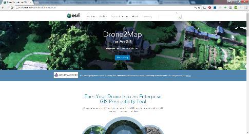

10 Indexed 3D Scene Layers are supported across the ArcGIS platform Publishing/Sharing Consuming Web ArcGIS Enterprise ArcGIS Online Drone2Map for ArcGIS Esri CityEngine Desktop Mobile ArcGIS Pro

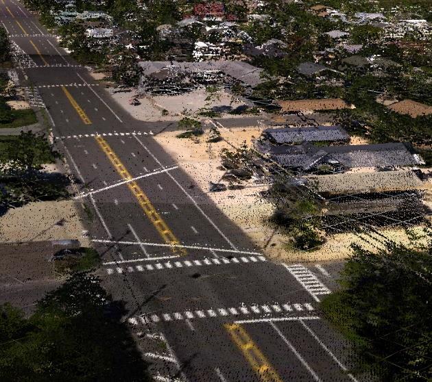
11 Demo: I3S Layer Examples

12 Joint work - Esri and HFT Stuttgart (Athanasios Koukofikis/ Prof. Dr. Volker Coors)
13 I3S rendered in Cesium Client via 3DPS I3S CityGML Esri I3S Processing Tools I3S 3DPS I3S Cesium Client

14 I3S rendered in Cesium Client via 3DPS


15
Indexed 3D Scene (I3S) Layers Specification
 Layers Specification") Indexed 3D Scene (I3S) Layers Specification Javier Gutierrez Product Engineer Lead Esri Özgür Ertac 3D Product Engineer Esri Germany Thank You to Our Generous Sponsor Agenda ArcGIS 3D Platform Authoring
Indexed 3D Scene (I3S) Layers Specification Javier Gutierrez Product Engineer Lead Esri Özgür Ertac 3D Product Engineer Esri Germany Thank You to Our Generous Sponsor Agenda ArcGIS 3D Platform Authoring
Overview of OGC Document Types
 Overview of Document Types Carl Reed February 2015 Overview The following set of slides documents the current set of key documents, their key policy and procedure actions, and key document work flows.
Understanding and Working with the OGC Geopackage. Keith Ryden Lance Shipman
 Understanding and Working with the OGC Geopackage Keith Ryden Lance Shipman Introduction - Introduction to Simple Features - What is the GeoPackage? - Esri Support - Looking ahead Geographic Things 3 Why
3D in the ArcGIS Platform. Chris Andrews
 3D in the ArcGIS Platform Chris Andrews Geospatial 3D is already all around us 3D is expanding the GIS community s opportunity to provide value 3D City & Infrastructure Models Generated 3D features Photogrammetrc
Creating Transparency, Openness and Trust: Modern Approach to Redistricting
 Creating Transparency, Openness and Trust: Modern Approach to Redistricting Richard Leadbeater, Esri Jerry Howe, Utah Legislature Larry Boden, Esri NCSL Legislative Summit Sunday, Aug. 6 11:15 am-12:15
ArcGIS Runtime: Building 3D Apps. Rex Hansen Adrien Meriaux
 ArcGIS Runtime: Building 3D Apps Rex Hansen Adrien Meriaux Agenda 3D across the ArcGIS Platform 3D in ArcGIS Runtime Road ahead ArcGIS 3D helps customers Create and Manage Design and Simulate Visualize
Creating, managing and utilizing a 3D Virtual City in ArcGIS Tamrat Belayneh Eric Wittner
 Creating, managing and utilizing a 3D Virtual City in ArcGIS 10.1 Tamrat Belayneh (tbelayneh@esri.com) Eric Wittner (ewittner@esri.com ) Contents 3D Mapping & Ingredients of a 3D Virtual City Creating
ArcGIS Enterprise: Architecture & Deployment. Anthony Myers
 ArcGIS Enterprise: Architecture & Deployment Anthony Myers 1 2 3 4 5 Web GIS Overview of ArcGIS Enterprise Federation & Hosted Server Deployment Patterns Implementation 1 Web GIS ArcGIS Enabling GIS for
3D in the Browser with WebGL. Chris Andrews 3D Product Manager Javier Gutierrez 3D Product Engineer
 3D in the Browser with WebGL Chris Andrews 3D Product Manager Javier Gutierrez 3D Product Engineer Just sayin This is not a programming class Goal is to help you learn about a technology area that impacts
THE CONCEPT OF. esilience MULTIDISCIPLINARY CENTER FOR EARTHQUAKE ENGINEERING RESEARCH
 THE CONCEPT OF 4 esilience 4 The Four Fundamental Properties of Resilience r r obustness esourcefulness r r edundancy apidity Enhancing resilience against multiple hazards using innovative spatial data
ASC X12 Administrative Policy and Procedure ASC X12 Examples Website
 ASC X12 Administrative Policy and Procedure ASC X12 Examples Website DL2013-48 DL2013-48 Copyright 2013, Accredited Standards Committee X12 Incorporated, Format 2013 Washington Publishing Company. Exclusively
Working with Feature Layers. Russell Brennan Gary MacDougall
 Working with Feature Layers Russell Brennan Gary MacDougall Working with Feature Layers Session will focus on feature access and editing Highlight new features added over the last few releases Agenda Introduction
Understanding and Using Metadata in ArcGIS. Adam Martin Marten Hogeweg Aleta Vienneau
 Understanding and Using Metadata in ArcGIS Adam Martin Marten Hogeweg Aleta Vienneau Adam Martin National Government Account Management R&D Open Data Marten Hogeweg National Government Professional Services
ArcGIS Enterprise: An Introduction. David Thom Solution Engineer State Government
 ArcGIS Enterprise: An Introduction David Thom Solution Engineer State Government What is ArcGIS Enterprise? ArcGIS Enterprise is server software that allows you to use infrastructure you manage to implement
Network Working Group. Category: Informational April A Uniform Resource Name (URN) Namespace for the Open Geospatial Consortium (OGC)
 Namespace for the Open Geospatial Consortium (OGC)") Network Working Group C. Reed Request for Comments: 5165 Open Geospatial Consortium Category: Informational April 2008 Status of This Memo A Uniform Resource Name (URN) Namespace for the Open Geospatial
Network Working Group C. Reed Request for Comments: 5165 Open Geospatial Consortium Category: Informational April 2008 Status of This Memo A Uniform Resource Name (URN) Namespace for the Open Geospatial
ArcGIS Enterprise Extending Services. Bill Major
 ArcGIS Enterprise Extending Services Bill Major Agenda Introduction Geoprocessing tools Server Object Extensions Server Object Interceptors Demo APPS Desktop Web Device SHARING SERVICES Portal API DATA
Esri Support for Geospatial Standards
 APRIL 2017 ArcGIS Is Open and Interoperable Esri Support for Geospatial Standards Copyright 2017 Esri All rights reserved. Printed in the United States of America. The information contained in this document
Using ArcGIS for Server. Javier Abadía, Esri España Peter McDaid, Esri UK
 Using ArcGIS for Server Javier Abadía, Esri España Peter McDaid, Esri UK 1. Intro 2. ArcGIS for Server = Geospatial Apps Server 3. Map Services Publishing Flow Apps 4. Spatial Functionality Services Publishing
ArcGIS Online: Best Practices for High-Demand Web Applications. Kelly Gerrow-Wilcox Bonnie Stayer Beth Romero
 ArcGIS Online: Best Practices for High-Demand Web Applications Kelly Gerrow-Wilcox Bonnie Stayer Beth Romero Agenda Communicating with Maps Who do you build your apps for? Layer Types Scalability and Response
GEOSPATIAL ERDAS APOLLO. Your Geospatial Business System for Managing and Serving Information
 GEOSPATIAL ERDAS APOLLO Your Geospatial Business System for Managing and Serving Information ERDAS APOLLO Do you have large volumes of data, a geographicallydistributed user base and rapidly changing
ArcGIS GeoEvent Server: Making 3D Scenes Come Alive with Real-Time Data
 ArcGIS GeoEvent Server: Making 3D Scenes Come Alive with Real-Time Data Morakot Pilouk, Ph.D. Senior Software Developer, Esri mpilouk@esri.com @mpesri Agenda 1 2 3 4 5 6 3D for ArcGIS Real-Time GIS Static
Feature Extraction from Imagery & Lidar. Kurt Schwoppe, Esri Mark Romero, Esri Gregory Bacon, Fairfax County
 Feature Extraction from & Lidar Kurt Schwoppe, Esri Mark Romero, Esri Gregory Bacon, Fairfax County Today s Speakers Image Processing Experts and Good Colleagues Kurt Schwoppe Industry Lead Esri Mark Romero
Scalable Platform Management Forum. Forum Status 10/30/2014
 Scalable Platform Management Forum Forum Status 10/30/2014 Disclaimer The information in this presentation represents a snapshot of work in progress within the DMTF. This information is subject to change
Understanding and using Metadata across the ArcGIS Platform. Aleta Vienneau Marten Hogeweg
 Understanding and using Metadata across the ArcGIS Platform Aleta Vienneau Marten Hogeweg Understanding and using Metadata across the ArcGIS Platform Metadata fundamentals ArcGIS platform Road ahead Metadata
Achieving Interoperability Using Open Standards
 FedGIS Conference February 24 25, 2016 Washington, DC Achieving Interoperability Using Open Standards Satish Sankaran Marten Hogeweg Agenda Understanding Interoperability What, Why and How? ArcGIS Platform
ArcGIS API for Silverlight An Introduction
 Esri Middle East and Africa User Conference December 10 12 Abu Dhabi, UAE ArcGIS API for Silverlight An Introduction Jo Fraley Agenda Silverlight platform API Overview Building Apps Road Ahead ArcGIS is
ArcGIS Online. The Road Ahead Geoff Mortson
 ArcGIS Online The Road Ahead Geoff Mortson gmortson@esricanada.com ArcGIS Online Easily create and share maps Delivered as intelligent maps Access on virtually any device anyone, anywhere Compliments and
System Administration
 System Administration IT4GIS Keith T. Weber, GISP GIS Director ISU-GIS Training and Research Center Today s Topics Users Privileges and shares User groups Other Topics: Mapped drives ROI TCO Data retention
Leveraging OGC Services in ArcGIS Server. Satish Sankaran, Esri Yingqi Tang, Esri
 Leveraging OGC Services in ArcGIS Server Satish Sankaran, Esri Yingqi Tang, Esri GIS Creating and Managing Geo Information Products - Proprietary - Open Specifications - Standards Dissemination of Geo
STATEMENT OF WORK BETWEEN UNIVERSITY SERVICES PMO and ENVIRONMENTAL SYSTEMS RESEARCH INSTITUTE INC. for the GIS Interactive Campus Web Map Project
 STATEMENT OF WORK BETWEEN UNIVERSITY SERVICES PMO and ENVIRONMENTAL SYSTEMS RESEARCH INSTITUTE INC. for the GIS Interactive Campus Web Map Project I. Scope This Statement of Work (SOW) is effective May
Getting Started with the ArcGIS API for JavaScript. Julie Powell, Paul Hann
 Getting Started with the ArcGIS API for JavaScript Julie Powell, Paul Hann Esri Developer Summit Berlin November 19 2012 Getting Started with the ArcGIS API for JavaScript ArcGIS for Server Is a Platform
DATA SHARING AND DISCOVERY WITH ARCGIS SERVER GEOPORTAL EXTENSION. Clive Reece, Ph.D. ESRI Geoportal/SDI Solutions Team
 DATA SHARING AND DISCOVERY WITH ARCGIS SERVER GEOPORTAL EXTENSION Clive Reece, Ph.D. ESRI Geoportal/SDI Solutions Team Geoportal Extension for ArcGIS Server Context within an Enterprise Spatial Data Infrastructure
ArcGIS Enterprise: Configuring Backups, Disaster Recovery, and Replication. Harrold Sompotan and Patrick Jackson
 ArcGIS Enterprise: Configuring Backups, Disaster Recovery, and Replication Harrold Sompotan and Patrick Jackson Agenda Brief History of WebGIS DR Tool Who, Why, What, When, How and Where Considerations
Dynamic Situational Awareness. Through Developer Applications
 Dynamic Situational Awareness Through Developer Applications Mission Focused Applications Building Apps to support operations Agile Simple High-Performance Defense Developers GIS Simplifies Working With
ASP.NET MVC Training
 TRELLISSOFT ASP.NET MVC Training About This Course: Audience(s): Developers Technology: Visual Studio Duration: 6 days (48 Hours) Language(s): English Overview In this course, students will learn to develop
Drone2Map for ArcGIS: Bring Drone Imagery into ArcGIS
 Drone2Map for ArcGIS: Bring Drone Imagery into ArcGIS Mike Sweeney 1 Drone2Map for ArcGIS Turn Drones into Enterprise Productivity Tools ArcGIS Drone2Map for ArcGIS Create 2D and 3D products from raw drone
Enterprise Geographic Information Servers. Dr David Maguire Director of Products Kevin Daugherty ESRI
 Enterprise Geographic Information Servers Dr David Maguire Director of Products Kevin Daugherty ESRI Outline Introduction Enterprise GIS vs. Spatially-enabled IS Architectures for building Enterprise GIS
County of Los Angeles. Chief Information Office Preferred Technologies for Geographic Information Systems (GIS) Version 2 May 2015
 Version 2 May 2015") County of Los Angeles Chief Information Office Preferred Technologies for Geographic Information Systems (GIS) Version 2 May 2015 CIO Preferred Technologies for GIS This document lists the preferred Geographic
County of Los Angeles Chief Information Office Preferred Technologies for Geographic Information Systems (GIS) Version 2 May 2015 CIO Preferred Technologies for GIS This document lists the preferred Geographic
Real-Time & Big Data GIS: Best Practices. Suzanne Foss Josh Joyner
 Real-Time & Big Data GIS: Best Practices Suzanne Foss Josh Joyner ArcGIS Enterprise With Real-time Capabilities Desktop Apps APIs visualization ingestion dissemination & actuation analytics storage Agenda:
PODS Association Update Lunchtime Webinar. January 11, 2018
 PODS Association Update Lunchtime Webinar January 11, 2018 Intro & Agenda PURPOSE: Making PODS useful and relevant Making the model process simpler, easier to use, and agile Notifying our members of what
Creating a 3D GIS Program in the City of Cambridge
 Creating a 3D GIS Program in the City of Cambridge JEFF AMERO CITY OF CAMBRIDGE ESRI User Conference, San Diego, CA July 13, 2017 Presentation Overview -Bringing 3D GIS to Cambridge -Components of the
Installation Geospatial Information and Services (IGI&S) - Update on Policy, Standards, Issues
 - Update on Policy, Standards, Issues") Installation Geospatial Information and Services (IGI&S) - Update on Policy, Standards, Issues Mr. David LaBranche, PE Geospatial Information Officer OASD(EI&E) February 14, 2017 Agenda IGI&S Policy Implementation
Installation Geospatial Information and Services (IGI&S) - Update on Policy, Standards, Issues Mr. David LaBranche, PE Geospatial Information Officer OASD(EI&E) February 14, 2017 Agenda IGI&S Policy Implementation
ETSI SUMMIT ON STANDARDIZATION AND OPEN SOURCE ECMA INTERNATIONAL: SOME EXPERIENCES
 ETSI SUMMIT ON STANDARDIZATION AND OPEN SOURCE ECMA INTERNATIONAL: STANDARDIZATION AND OPEN SOURCE SOME EXPERIENCES ECMA INTERNATIONAL: Standardization and Open Source Some Experiences Dr. István Sebestyén
FDO Data Access Technology at a Glance
 Autodesk Geospatial FDO Data Access Technology at a Glance Work seamlessly with your geospatial data whatever the format 1 The Challenge The growing need for openness and interoperability between traditional
ArcGIS for Server Michele Lundeen
 ArcGIS for Server 10.1 Michele Lundeen Summary Vision Installation and Configuration Architecture Publishing Functional Enhancements Cloud Migration and Best Practices Powerful GIS capabilities Delivered
Administering Your ArcGIS Enterprise Portal Bill Major Craig Cleveland
 Administering Your ArcGIS Enterprise Portal Bill Major Craig Cleveland Agenda Welcome & Introduction to ArcGIS Enterprise Portal for ArcGIS Administration - Basic Configuration - Advanced Configuration
What s New in ArcGIS 10.4 for Server
 What s New in ArcGIS 10.4 for Server Derek Law, Esri Jan 19, 2016 Esri Southwest User Conference Agenda Product story GIS Server Sharing content from ArcGIS Pro Portal for ArcGIS Client Apps Summary Strongly
Leveraging SAP HANA and ArcGIS. Melissa Jarman Eugene Yang
 Melissa Jarman Eugene Yang Outline SAP HANA database ArcGIS Support for HANA Database access Sharing via Services Geodatabase support Demo SAP HANA In-memory database Support for both row and column store
GeoServices REST API SWG response to justification comments for No-Votes
 Open Geospatial Consortium Date: 2013-05-10 Reference number of this document: OGC 13-031r1 Category: Technical Note Editor: Clemens Portele, Satish Sankaran GeoServices REST API SWG response to justification
Working with the ArcGIS Viewer for Flex Application Builder
 Working with the ArcGIS Viewer for Flex Application Builder Esri Canada User Conference St. John s November 15, 2012 Presented By: Greg Yetman gyetman@esri.ca Agenda This seminar is designed to help you
ArcGIS Viewer for Microsoft Silverlight An Introduction
 Esri International User Conference San Diego, CA Technical Workshops July 12, 2011 ArcGIS Viewer for Microsoft Silverlight An Introduction Art Haddad, Rich Zwaap, and Derek Law Agenda Background Product
Unity In diversity. ArcGIS JS API as an Integration Tool. RICARDO BANDEIRA - IplanRio
 Unity In diversity ArcGIS JS API as an Integration Tool RICARDO BANDEIRA - IplanRio Introduction Integrating the processes of an entire City Hall is not an easy task. Decision making requires updated information
What s New in ArcGIS 10.3 for Server. Tom Shippee Esri Training Services
 What s New in ArcGIS 10.3 for Server Tom Shippee Esri Training Services Today s Agenda What is ArcGIS for Server at 10.3 - ArcGIS Platform story - Expanding ArcGIS for Server paradigm What s new in ArcGIS
Drone2Map for ArcGIS: Bring Drone Imagery into ArcGIS. Will
 Drone2Map for ArcGIS: Bring Drone Imagery into ArcGIS Will Meyers @MeyersMaps A New Window on the World Personal Mapping for Micro-Geographies Accurate High Quality Simple Low-Cost Drone2Map for ArcGIS
Get a Second Opinion: Enterprise GIS Health Checks. David Crosby Esri Southeast Regional Professional Services Charlotte, NC
 Get a Second Opinion: Enterprise GIS Health Checks David Crosby Esri Southeast Regional Professional Services Charlotte, NC E M E R A L D S A P P H I R E T H A N K Y O U T O O UR SPONSORS What is an Enterprise
Securing your Standards Based Services. Rüdiger Gartmann (con terra GmbH) Satish Sankaran (Esri)
 Satish Sankaran (Esri)") Securing your Standards Based Services Rüdiger Gartmann (con terra GmbH) Satish Sankaran (Esri) Agenda What are your security goals? Access control Standards and interoperability User management and authentication
Securing your Standards Based Services Rüdiger Gartmann (con terra GmbH) Satish Sankaran (Esri) Agenda What are your security goals? Access control Standards and interoperability User management and authentication
Development of the S-100 based Ice Information Product
 1 10 th CSPWG MEETING Wellington, New Zealand, 21-24 January, 2014 CSPCWG10-INF4 Development of the S-100 based Ice Information Product Submitted by: Executive Summary: Related Documents: Related Projects:
Web Mapping Applications with ArcGIS. Bernie Szukalski Derek Law
 Web Mapping Applications with ArcGIS Bernie Szukalski Derek Law Agenda Web Mapping and Map Services Fundamentals ArcGIS Web Mapping Applications - Hosted online - Hosted on-premise Summary Web Application
Integrating ArcGIS desktop in data interoperability environments with heterogeneous GIS clients
 Data-Interoperability based on Common Databases Integrating ArcGIS desktop in data interoperability environments with heterogeneous GIS clients M.Sc Abdurasyid Moestofa / Prof. Rainer Kettemann Stuttgart
Integrating Imagery into ArcGIS Runtime Application. Jie Zhang, Zhiguang Han San Jacinto, 5:30 pm 6:30 pm
 Integrating Imagery into ArcGIS Runtime Application Jie Zhang, Zhiguang Han San Jacinto, 5:30 pm 6:30 pm Overviews Imagery is an essential component of ArcGIS - Visualization, Processing and Analysis -
Creating and Maintaining Your 3D Basemap. Brian Sims Dan Hedges Gert van Maren
 Creating and Maintaining Your 3D Basemap Brian Sims Dan Hedges Gert van Maren Complementary Resource Email (no marketing) A copy of the presentation Links to today s web demos Links to training materials
Supporting the Army Enterprise with ESRI and Citrix
 Supporting the Army Enterprise with ESRI and Citrix Julie Carter, Geospatial Engineer Installation Geospatial Information and Services (IGI&S) Program Office of the Assistant Chief of Staff for Installation
Advances in GIS help create Smarter Communities
 Advances in GIS help create Smarter Communities POP(ovich) Quiz Who is a Desktop User? Who is an ArcGIS Online User? Who is a ArcGIS Server Admin? Who is a Programmer? Who works with or for a government
Web AppBuilder Presented by
 Web AppBuilder Presented by Agenda Product overview Web AppBuilder for ArcGIS tour What s new in the ArcGIS Online June 2016 update Customization Community and Resources Summary The ArcGIS Platform enables
Scientific and Multidimensional Raster Support in ArcGIS
 Scientific and Multidimensional Raster Support in ArcGIS Sudhir Raj Shrestha sshrestha@esri.com Brief breakdown Scientific Multidimensional data Ingesting Scientific MultiDim Data in ArcGIS Ingesting and
Project Deliverable. Report on 4 D models in World Wide Web of all test areas
 Project Deliverable Number D4.2 Title Month Report on 4 D models in World Wide Web of all test areas M33 Language English Revisions record Rev. N. Author Notes Date 0 Gabriele Guidi Document framework
Sharing Web Layers and Services in the ArcGIS Platform. Melanie Summers and Ty Fitzpatrick
 Sharing Web Layers and Services in the Platform Melanie Summers and Ty Fitzpatrick Agenda Platform overview - Web GIS information model - Two deployment options Pro Sharing - User experience and workflows
ArcGIS for Server: What s New. Philip Heede, Jay Theodore
 ArcGIS for Server: What s New Philip Heede, Jay Theodore Agenda GIS server Web GIS: Portal for ArcGIS ArcGIS for Server Extensions - GeoEvent Extension - Production Mapping Primary target for new functionality
Providing Interoperability Using the Open GeoServices REST Specification
 2013 Esri International User Conference July 8 12, 2013 San Diego, California Technical Workshop Providing Interoperability Using the Open GeoServices REST Specification Satish Sankaran Kevin Sigwart What
Interoperability and Standards Supports in ArcGIS
 Esri International User Conference San Diego, California Technical Workshops July 26, 2012 Interoperability and Standards Supports in ArcGIS Satish Sankaran, Esri Yingqi Tang, Esri Agenda Esri s participation
Interoperability with ArcGIS
 Interoperability with ArcGIS Satish Sankaran Marten Hogeweg Agenda Understanding Interoperability What, Why and How? ArcGIS Platform An Open Platform Supporting Interoperability Examples from the real
Managing Image Data on the ArcGIS Platform Options and Recommended Approaches
 Managing Image Data on the ArcGIS Platform Options and Recommended Approaches Peter Becker Petroleum requirements for imagery and raster Traditional solutions and issues Overview of ArcGIS imaging capabilities
Configuring ArcGIS Enterprise in Disconnected Environments
 Configuring ArcGIS Enterprise in Disconnected Environments BILL MAJOR Disconnected Environments Not everyone has internet access? How many of you run disconnected today, i.e. no internet access? Many customers
Best Practices for Designing Effective Map Services
 2013 Esri International User Conference July 8 12, 2013 San Diego, California Technical Workshop Best Practices for Designing Effective Map Services Ty Fitzpatrick Tanu Hoque What s in this session Map
Understanding ArcGIS Online - why organizations should embrace the cloud now
 Understanding ArcGIS Online - why organizations should embrace the cloud now Presented to: GeoAlberta - workshop Presented by: David Parry September 25, 2013 Today s Agenda Introduction - Why the Cloud?
Open Source Software: What and Why?
 ESRI and Open Source A Love Story Presented by Bates Rambow Open Source Software: What and Why? What Software that has its source code published for anyone to inspect the source code. Generally released
ArcGIS Online: Three-and-a-Half Ways to Create Tile Layers. Eric Anderson & Adam Eversole Esri Support Services
 ArcGIS Online: Three-and-a-Half Ways to Create Tile Layers Eric Anderson & Adam Eversole Esri Support Services Agenda 1. Introduction 2. What is a tile layer 3. How a tile layer works 4. The 3 ½ ways to
TRAINING GUIDE. Lucity GIS. Web Administration
 TRAINING GUIDE Lucity GIS Web Administration Lucity GIS Web Administration Contents Portal Config and SSO... 2 Registering with Portal... 2 Behind the Scenes... 4 Resetting Portal Integration... 5 Single
SIX REASONS. You Should Use ArcGIS API 4.0 for JavaScript. By Julie Powell, Esri Product Management
 SIX REASONS You Should Use ArcGIS API 4.0 for JavaScript By Julie Powell, Esri Product Management Since 2008, developers have used ArcGIS API for JavaScript to build powerful web mapping applications.
Geospatial Enterprise Search. June
 Geospatial Enterprise Search June 2013 www.voyagersearch.com www.voyagersearch.com/demo The Problem: Data Not Found The National Geospatial-Intelligence Agency is the primary source of geospatial intelligence
PODS Lite. Executive Summary
 PODS Lite Executive Summary Introduction Since 1998, the Pipeline Open Data Standard (PODS) Association has been focused on providing a comprehensive, open, vendor-neutral, highly scalable, and proven
As an Author, your tasks include submission; submitting revised copy; copyediting; and proofreading.
 Chapter 5. Authors Overview OJS exists to serve Authors as well as journals. Not only does OJS provide an easy-to-use submission process, it can collect and disseminate key information about Authors and
Image Management in ArcGIS. Vinay Viswambharan
 Image Management in ArcGIS Vinay Viswambharan Topics covered Primary Imagery Management Information Model - Mosaic Dataset Sharing Imagery using mosaic datasets/image services. Image Services and Cloud
University of Maryland at College Park Department of Geographical Sciences GEOG 477/ GEOG777: Mobile GIS Development
 University of Maryland at College Park Department of Geographical Sciences GEOG 477/ GEOG777: Mobile GIS Development Instructor: Dr. Ruibo Han Office: LeFrak Hall (LEF) 1111B Email: ruibo@umd.edu (preferred)
Getting Started with ArcGIS for Server. Charmel Menzel and Ken Gorton
 Getting Started with ArcGIS for Server Charmel Menzel and Ken Gorton Agenda What is ArcGIS for Server? Types of Web services Publishing resources onto the Web Clients to ArcGIS for Server Editions and
International Organization for Standardization Technical Committee 211 (ISO/TC211)
") Esri Support for Geospatial Standards: Open Geospatial Consortium (OGC) International Organization for Standardization Technical Committee 211 (ISO/TC211) An Esri White Paper April 2015 Copyright 2015
Esri Support for Geospatial Standards: Open Geospatial Consortium (OGC) International Organization for Standardization Technical Committee 211 (ISO/TC211) An Esri White Paper April 2015 Copyright 2015
ArcGIS Enterprise: Portal Administration BILL MAJOR CRAIG CLEVELAND
 ArcGIS Enterprise: Portal Administration BILL MAJOR CRAIG CLEVELAND Agenda Welcome & Introduction to ArcGIS Enterprise Portal for ArcGIS - Basic Configuration - Advanced Configuration - Deploying Apps
Editing Versioned Geodatabases : An Introduction
 Esri International User Conference San Diego, California Technical Workshops July 24, 2012 Editing Versioned Geodatabases : An Introduction Cheryl Cleghorn Shawn Thorne Assumptions: Basic knowledge of
Introduction to Geodatabase and Spatial Management in ArcGIS. Craig Gillgrass Esri
 Introduction to Geodatabase and Spatial Management in ArcGIS Craig Gillgrass Esri Session Path The Geodatabase - What is it? - Why use it? - What types are there? - What can I do with it? Query Layers
ESRI Technology Update. Joe Holubar Larry Young
 ESRI Technology Update Joe Holubar Larry Young Continued Improvement Improving Quality and Extending and Refining Functionality First Half of 2009: Minor Update Release (ArcGIS 9.3.1) ArcGIS Explorer Fall
Housekeeping Tips. Access a PDF of the slides, access the speakers bios. Participate in polls
 Housekeeping Tips Access a PDF of the slides, access the speakers bios Participate in polls Ask a question! or send a Tweet at @directionsmag, and include #GoogleWebinar An on-demand recording of today
Esri CityEngine and the Oculus Rift: GIS for Next-Generation Virtual Reality
 Esri CityEngine and the Oculus Rift: GIS for Next-Generation Virtual Reality Brooks Patrick Solutions Engineer 3D Markets BPatrick@esri.com Esri UC 2014 Technical Workshop The entertainment industry continues
IMAGERY FOR ARCGIS. Manage and Understand Your Imagery. Credit: Image courtesy of DigitalGlobe
 IMAGERY FOR ARCGIS Manage and Understand Your Imagery Credit: Image courtesy of DigitalGlobe 2 ARCGIS IS AN IMAGERY PLATFORM Empowering you to make informed decisions from imagery and remotely sensed data
ArcGIS Enterprise: Performance and Scalability Best Practices. Darren Baird, PE, Esri
 ArcGIS Enterprise: Performance and Scalability Best Practices Darren Baird, PE, Esri dbaird@esri.com What is ArcGIS Enterprise What s Included with ArcGIS Enterprise ArcGIS Server the core web services
Paper for Consideration by CHRIS. Cooperation Agreement Between IHO and DGIWG
 CHRIS17-12.2A Paper for Consideration by CHRIS Cooperation Agreement Between IHO and DGIWG Submitted by: Executive Summary: Related Documents: IHB The IHO standards for digital hydrographic information
The Oracle Enterprise Geodatabase (EGDB) Charlie Crocker Farallon Geographics, Inc.
 Charlie Crocker Farallon Geographics, Inc.") The Oracle Enterprise Geodatabase (EGDB) Charlie Crocker Farallon Geographics, Inc. www.fargeo.com Norcal URISA Chapter Meeting 2/9/2005 Todays Goals Enterprise geodatabase defined Roles Oracle can play
The Oracle Enterprise Geodatabase (EGDB) Charlie Crocker Farallon Geographics, Inc. www.fargeo.com Norcal URISA Chapter Meeting 2/9/2005 Todays Goals Enterprise geodatabase defined Roles Oracle can play
Leveraging OGC Services in ArcGIS Server. Satish Sankaran Yingqi Tang
 Leveraging OGC Services in ArcGIS Server Satish Sankaran ssankaran@esri.com Yingqi Tang ytang@esri.com Agenda Interoperability Enablers OGC and esri OGC Web Services ArcGIS and OGC Web Services - @ version
Web Services for Geospatial Mobile AR
 Web Services for Geospatial Mobile AR Introduction Christine Perey PEREY Research & Consulting cperey@perey.com Many popular mobile applications already use the smartphone s built-in sensors and receivers
Trimble GeoCollector for ArcGIS: An Introduction. Morgan Zhang (Esri), Matthew Morris (Trimble)
, Matthew Morris (Trimble)") Trimble GeoCollector for ArcGIS: An Introduction Morgan Zhang (Esri), Matthew Morris (Trimble) Overview Introduction to mobile GIS Overview of ArcGIS for Windows Mobile Overview of Trimble Positions software
Trimble GeoCollector for ArcGIS: An Introduction Morgan Zhang (Esri), Matthew Morris (Trimble) Overview Introduction to mobile GIS Overview of ArcGIS for Windows Mobile Overview of Trimble Positions software
From 2D to 3D at Esri
 From 2D to 3D at Esri Paul Hardy, Esri Inc phardy@esri.com, Cambridge, UK SHORT PAPER This short paper provides an overview of the 3D capabilities of a modern GIS, illustrated by the Esri ArcGIS system,