LIDAR Workshop IPSRS Commission 1
|
|
|
- Marsha Watson
- 5 years ago
- Views:
Transcription

1 LIDAR Workshop IPSRS Commission 1 2-Jul-2007, Ljubliana, Slovenia Arthur Rohrbach, Leica Geosystems, Switzerland
2 Presentation topics 1. Basics of Airborne LIDAR Sensing Technology 2. Typical Applications (for Airborne LIDAR Technology) 3. System Components (of Airborne LIDAR Scanners) 4. Performance Parameters (for Airborne LIDAR Missions) 5. Operational Workflow (for Airborne LIDAR Operations) 6. Costs Parameters (for Airborne LIDAR Operations) 7. Practical Examples / Application Cases / Planning 8. Dual Airborne Sensor & LIDAR Scanner Systems 9. Outlook / Trends 2
3 Topic - 1 Basics of Airborne LIDAR Sensing Technology 3
4 Typical LIDAR technology implementation Develop lat/lon/el of points on ground based on: Aircraft position (lat/long/h) Aircraft orientation (roll/pitch/heading) Scan angle Round-trip propagation time of laser pulse Atmospherics Raw data recorded in air (System) & on ground (DGPS base station) Recorded data post-processed on ground Multiple-return intensity concerns attributes of the range measurement Time or distance Intensity 4

5 Basic Lidar Data Layers Surface Mapping Vegetation Classification Ground Classification Laser Point Data 5
6 Fundamentals of multiple-return technology example for 1- and 3-return scenarios 1 st return from tree top 1 st (and only) return from ground 2 nd return from branches 3 rd return from ground 6
7 Concept of multi-return intensity measurement Multiple return intensity measurement is a natural extension of the measurement process Footprint Systems featuring 1-5 return intensity measurement are available Multiple ranges and associated intensities are generated as the laser pulse hits various levels in the forest canopy Return waveform is generated by all reflective surfaces within the laser footprint 7
8 Multiple-return intensity analysis Laser Footprint Start Pulse Intensity 1 Intensity 2 Intensity 3 Detector Signal Range 1 Range 2 Range 3 Increases the possibility of classifying otherwise ambiguous data by looking at the relationship between intensity and time variables, simultaneously 8
9 Multiple return intensity measurement methodology Each return can be considered to represent a single pulse at a given range from the airborne vehicle Each return pulse s width and intensity can be plotted, referenced to some fixed point, say the start of the first return Start Pulse Intensity 1 Intensity 2 Intensity 3 Detector Signal Range 1 Range 2 Range 3 Intensity Intensity Profile Time 9

10 Wavelengths of LiDAR Sensors Reflectance Transmittance Near-IR Maple Piñon Pine Mid-IR Atmospheric Transmittance Cheatgrass Soil 532 nm 900 nm FLI-MAP I/II 1047/1057/1064 nm Optech ALTM Leica ALS Topeye Riegl 1540 nm TopoSys I/II LADS / SHOALS / Hawkeye Bathymetric Systems 10
11 Topic - 2 Typical Applications (for Airborne LIDAR Technology) 11
12 Summary of applications broad categories of applications Modeling Visualization Change detection Applications are limited only by Sensor spatial resolution (typically to 10 points/m2 with 250+ m swath in fixed-wing aircraft) Accuracy (typically 5-15 cm) 12


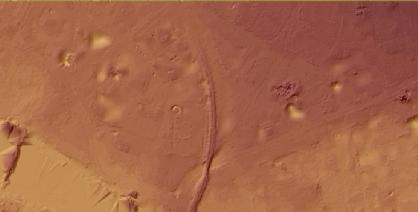
13 Forestry accurate ground profiling during leaf-on conditions 13

14 Forestry tree height and biomass estimation Top View Color Coded by elevation Section view color coded by class Brown = Ground Green = Vegetation Red = Model Key Points 14

15 Hydrology coastal engineering Image created using TerraScan 15

16 Hydrology erosion studies 16

17 Hydrology flood plain mapping and simulation 17

18 Mining and construction accurate volumetric calculations 18

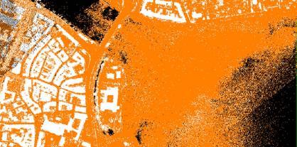
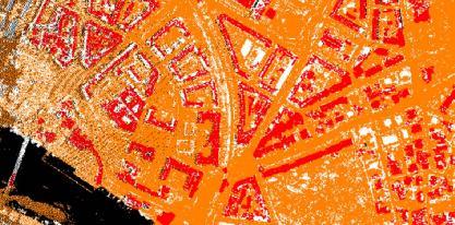
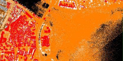
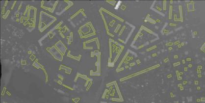
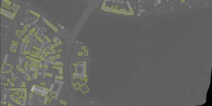
19 Urban modeling building extraction 19
20 Urban modeling building extraction 20


21 Urban modeling detailed as-built data 21


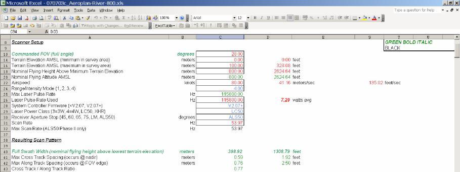
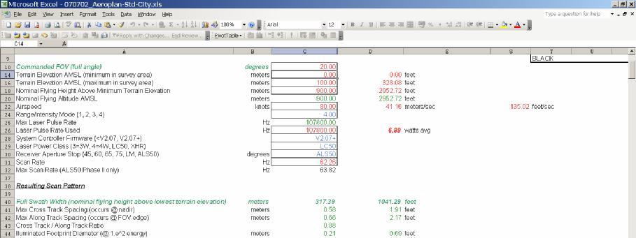
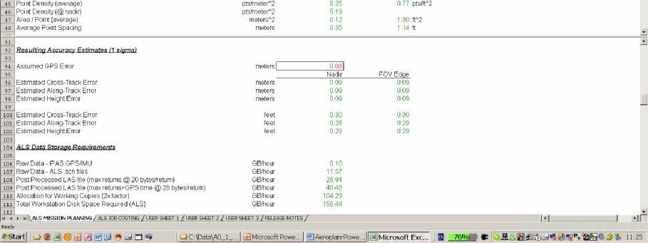
22 Urban modeling large areas with high level of detail Flight parameters: altitude: 800m AGL, FOV: 35 degrees, scan rate: 29.4 Hz, pulse rate: 38 khz, line spacing: 250m, number of lines: 18 Data parameters: area = 11.7 X 5 km (58.5 km2), number of points = 103 million, average density = 1.7 pts m2 22

23 Corridor mapping power line position and vegetation clearance 23


24 Corridor mapping power line position and vegetation clearance 24

25 Power line and infrastructure condition 25

26 Corridor mapping highway corridor mapping 26


27 Airspace intrusion detection comparing bare earth + DSM 27

28 Data fusion surface and intensity data 28
29 Topic - 3 Main System Components (of Airborne LIDAR Scanners) 29
30 Complete Airborne LIDAR Scanner ( Leica ALS50-II ) including System Control & Flight Navigation Guidance 30

31 Data Sensing <> Scanner Head ( Leica ALS50-II ) New generation system provides greater point density, while increasing accuracy In virtually all scenarios, ALS50-II with MPiA out-performs competing products The ALS50-II provides a greater FOV and greater roll compensation range than competing products The ALS50-II Scanner fits in small places like helicopter pods 31
 Installation in Helicopter")
32 Data Sensing <> Scanner Head ( Leica ALS50-II ) Installation in Helicopter Pod 32
 Interface to a variety of external FMS hardware Potential for use as 4 th sensor")
33 Data Control & Storage ( Leica ALS50-II ) 3 Highly-flexible auxiliary sensor ports (included) Cameras Thermal sensors Hyperspectral sensors Other external sensors / systems Accesses common GPS/IMU data Dedicated flight management system port (included) Interface to a variety of external FMS hardware Potential for use as 4 th sensor port 33


34 System Control & Navigation ( Leica ALS50-II ) Airborne-qualified operator interface no laptops Highly integrated flight management Modularity with minimal external cabling Single-drive recording of GPS/IMU and scanner data All controls operated via GUI Shutter Laser output regulation AGC settings 34

35 Real-time digital camera ( Leica ALS50-II ) enhances editing Real-time imagery to check for clouds / haze in line of sight JPEG images recorded at preset interval for post flight terrain / cover verification Images time-indexed and contain all georeferencing data 35
 Lens (35, 60 or 100 mm) CC105 Camera")
36 Mid-Format Camera System (Leica MidiPix 39MPx) product configuration CH39 Camera Head (39 MP) Lens (35, 60 or 100 mm) CC105 Camera Controller 36


37 Digital Frame Camera Head typical installations Front-mount, dual CH39, non-isolated Side-mount, CH39 + thermal sensor, isolated 37
38 Topic - 4 Performance Parameters (for Airborne LIDAR Missions) 38
39 Key performance parameters Performance of Optical System Accuracy of Components Performance of Laser Multiple Pulse capability (MPiA) Performance of IMU Performance of GPS Multiple Pulse capability (MPiA) Robustness / Calibration stability of system components 39
 Fly in less-desirable atmospheric conditions (e.g., haze/smoke) Preserves performance, even at today s high pulse rates 40")
40 Large Optical Aperture To see more Detect smaller targets at higher altitude (e.g., power line profiling) Fewer drop outs on low-reflectivity terrain features (e.g., asphalt pavement) Fly in less-desirable atmospheric conditions (e.g., haze/smoke) Preserves performance, even at today s high pulse rates 40
41 Robust components To assure continuous high performance Laser features consistent pulse shape over wide range of pulse rates for high range accuracy/low range jitter High-accuracy scan angle encoder preserves planimetric accuracy as altitude increases Powerful galvanometer scanner Allows use of large-aperture optics Scans fast at any given FOV, allowing: Small along-track spacing in fixed wing aircraft Balanced along-track and cross-track (very important when using high pulse rates and/or higher-speed aircraft) Allows widest available FOV and greatest roll compensation range 41
42 High Laser Performance To ensure clean pulses even at high pulse rates Typical laser pulse ALS50-II laser pulse 33 khz 42
43 High Laser Performance To ensure clean pulses even at high pulse rates Typical laser pulse ALS50-II laser pulse 50 khz 43
44 High Laser Performance To ensure clean pulses even at high pulse rates Typical laser pulse ALS50-II laser pulse 100 khz 44
45 High Laser Performance To ensure clean pulses even at high pulse rates Typical laser pulse ALS50-II laser pulse? 150 khz 45
46 MPiA Multiple Pulse in the Air technology significant advancement in range measurement > 1 st Press release, 5-Oct-06: MPiA technology (Leica ALS50-II) Allows rangefinding system to operate at double the pulse rate of current systems at any given altitude -Uncomplicated upgrade path for existing systems (Leica ALS50) > Significant performance benefits: Double the data density at current swath Double the swath at current density Data acquisition cost savings approaching 50% 46
47 Fundamentals of MPiA technology single-pulse technology limits pulse rate
48 Fundamentals of MPiA technology MPiA allows doubling of pulse rate
49 Gain in Pulse Rate & Accuracy (Leica ALS50-II-MPiA) Assuming a 5 cm GPS error Max Pulse Repetition Frequency (PRF, Hz) PRF, 2PiA PRF, 1PiA xy, FOV edge xy, Nadir z, FOV edge z, Nadir Accuracy (m, 1 40 FOV) Flight Height (m)


50 MPiA intensity image (Leica ALS50-II) 2.5 points/m 2 with 1000 m swath 50
 low")

51 MPiA surface model (Leica ALS50-II) low range noise for smoother surface models 51
")

52 MPiA intensity & surface model (Leica ALS50-II) Combined result from 150 khz pulse rate from 1250 m AGL 52


53 MPiA intensity image 2.5 points/m 2 with 1000 m swath 53


54 Ultra-high point density with superior accuracy from an 125-knot aircraft! 54
55 Topic - 5 Operational Workflow (for Airborne LIDAR Operations) 55
56 Airborne LIDAR Workflow - General comments Workflow costs often follow a pattern 5% of costs for job / mission planning 10% of costs for data acquisition 85% of costs for data processing The 85% figure can vary substantially depending on nature final of deliverables Raw point cloud versus bare earth model Feature collection required (building outlines, breaklines, etc.) Level of quality checking 56
57 Point cloud-based workflow (Leica ALS50) based on TerraScan/TerraModeler Flight Planning FPES Flight Planning FlightOptimization Project Management Costestimation Collection record DGPS base station data FCMS Airborne Operations record navigation data GPS IMU record scanner data range scan angle intensity timing info flight management Flightguidance Sensor Release Flight Evaluation DGPS ground station files GPS and IMU files *.SCN raw scanner files FPES Check of Completeness QualityControl Project Management Costcalculation ReflightPlanning IPAS Pro / GrafNav DGPS processing (GrafNav) Blended Solution (IPAS) Position and Attitude file Processing ALS50 Post Processor point cloud generation output formatting LDI, LAS, ASCII projection -WGS 84, UTM, state plane, etc. datum (state plane only) Attune boresight calibration TerraScan tiling coverage verification outlier removal bare earth thinning catenary generation tree cell placement building outlines TerraModeller TIN/contour control report deliverables MicroStation 57


58 Flight Planning & Evaluation Software (Leica FPES) Project Explorer Shows the project in a tree-like directory Graphic view Property view Display of summarized data Data view Display of detailed data 58
 Multiple windows for different maps")

59 Flight Planning & Evaluation Software (Leica FPES) Multiple windows for different maps Maps can have Different Datum Different zoom level Example Topographic map Airspace map 59
 Footprints on")
 Footprint flight")

60 Flight Planning & Evaluation Software (Leica FPES) Footprints on DTM Footprint planning AOI Flight line Event (Photo) Footprint flight Flight Line Event (Photo) AOI, hilly terrain Single line, mountainous terrain 60
 the key to all lidar data processing Thinning of point")

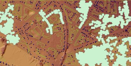
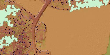
61 TerraSolid Processing Software TerraScan Automatic and manual classification of laser data (ground, vegetation, ) the key to all lidar data processing Thinning of point cloud 2D and 3D viewing of laser points TerraModeller TIN/Contour generation Import or manually add break lines Cut/Fill calculations Interface with PRO600 for feature extraction 61
62 Grid-Based workflow (Leica ALS50) based on VLS LIDAR Analyst Flight Planning Collection Flight Evaluation Processing record DGPS base station data FCMS Airborne Operations DGPS ground station files GPS and IMU files IPAS Pro / GrafNav DGPS processing (GrafNav) Blended Solution (IPAS) Position and attitude file ALS50 Post Processor point cloud generation output formatting LDI, LAS, ASCII projection -WGS 84, UTM, state plane, etc. datum (state plane only) -NGVD 29, NAVD 88 separation of first-, last-pulse point clouds manual tiling FPES Flight Planning FlightOptimization Project Management Costestimation record navigation data GPS IMU record scanner data range scan angle intensity timing info flight management Flightguidance Sensor Release *.SCN raw scanner files FPES Check of completeness QualityControl Project Management Costcalculation ReflightPlanning Leica Attune boresight calibration LIDAR Analyst Gridding coverage verification outlier removal bare earth thinning catenarygeneration tree cell placement building outlines TIN/contour control report ERDAS Imagine or ArcGIS Deliverables: Shape Files (e.g. buildings, trees forrestareas) 62
63 Starting point point cloud block loaded All returns shown Ortho point cloud view Color coded by elevation 63


64 Comparison of rendered 1 st returns to point cloud point cloud gridded 64
65 Comparison of rendered last returns to point cloud point cloud gridded 65

66 Bare earth extraction point cloud gridded 66
67 Building extraction point cloud gridded 67

68 Tree extraction point cloud gridded 68
69 Forest extraction point cloud gridded 69
70 LIDAR Processing Workflow (Leica ALS50 MidiPix 39MPx) additional digital camera workflow items in amber Planning Collection Processing FPES Mission Planning mode altitude scan rate FOV flight speed flight lines flight height lens FL shutter speed frame rate Ground Operations GPS1200 record DGPS base station data ALS50, FCMS, CamGUI Airborne Operations record position and attitude data GPS IMU event marks record scanner data range scan angle intensity timing info record camera data photo ID file raw frames GrafNav DGPS processing IPAS Pro extract position and attitude data CDPP Bayer conversion IPAS Pro trajectory processing IPAS CO calculate exterior orientations position and attitude file real-time nav file *.SCN raw scanner files EO file ALS50 Post Processor point cloud generation output formatting LDI, LAS, ASCII projection -WGS 84, UTM, state plane, Swiss, TW 97, usersupplied datum (state plane only) -NGVD 29, NAVD 88 Attune laser boresight calibration LPS camera boresight, orthophoto generation LAS file orthophotos TerraScan tiling coverage verification outlier removal bare earth thinning catenary generation TerraModeller TIN/contour control report deliverables MicroStation 70
71 Topic - 7 Practical Examples / Planning of Airborne LIDAR Applications 71
72 Application Cases A. Corridor Mapping (power line, pipeline, road, railway) B. Forestry Mapping / Monitoring (Resource Mngt) C. Hydrology / River bed Mapping (Flood Modelling) D. City Mapping (3D-Modelling, Telecom) E. Costal Mapping (Erosion / Change Detection) F. Basic DEM / DSM Generation (Key Reference for Orthophoto Mapping) 72

73 A. Corridor Mapping - 1 (power lines) power line position and vegetation clearance 73
74 74


75 A. Corridor Mapping - 2 (roads, railways) 75
76 76
77 2. Forestry Mapping / Monitoring (Resource Management) 77
78 78


79 3. Hydrology / River bed Mapping (Flood Modelling) 79
80 80
81 4. City Mapping (3D-Modelling, Telecom) 81
82 82

83 5. Costal Mapping (Erosion / Change Detection) 83
84 84


85 6. Basic DEM / DSM Generation (Key Reference for Orthophoto Mapping) < by color elevation by echo > < by intensity (grey scale) 85

86 86
87 Topic - 8 Dual Airborne Sensor Systems ( ADS40 & ALS50 ) Dual LIDAR Scanner Systems ( Airborne ALS50-II & Terrestrial HDS ) 87
")
88 Dual - LIDAR - Systems (Airborne & Ground based) 88

89 LIDAR Data Fusion 89
90 Dual - Airborne Sensing - Systems (Digital Sensor & LIDAR Scanner) 90
91 Topic - 9 Outlook / Trends in Digital Elevation Modeling from an airborne LIDAR perspective 91
92 3 factors that will change how we use DEM data system performance, processing efficiency, data delivery System performance Affects suitability for purpose Reduce cost per DEM point Affects data acquisition cost Processing efficiency will continue to be a major driver in cost per DEM point Data delivery the big enabler New applications Increased data demand Easy access Broader market Economies of scale 92
93 System performance trends point density is up Over the past 10 years: System pulse rates have increased 30x Point spacing has decreased 5.5X Major breakthroughs, such as Multiple Pulses in Air (MPiA) and enhanced laser technologies will continue to push data acquisition efficiency upward How much detail is enough? When does mapping become surveillance? Pulse Rate (Hz) y = 7E-267e x R 2 = Year 93
94 System performance trends error is down Improvements in technology have steadily reduced error Ranging errors GPS errors improved, but are now the dominant error source at low altitude Error levels are keeping pace with increased data density BEWARE EXTRAPOLATION!!! Accuracy (m) 0.3 y = x R 2 = Year 94
95 Processing efficiency what trend? Processing has continued to take roughly the same time per flight hour Gains have been mostly due to increased computing power Big opportunity for improvement After 10 years of LIDAR development, there are finally multiple 3 rd -party competitors for filtering / editing SW VLS Q Coherent TerraSolid 95
96 Data delivery is it an image? or is it a surface? who delivers it? Constraints on data delivery 2D presentation versus 3D data Data transmission method Specialized firms will likely be the innovators owners of data users in our industry (e.g., ESRI, Oracle) owners of data users in other markets (e.g., Google, Microsoft) 96
97 Conclusions Cost per DEM point continues to decrease Quality of DEM data continues to increase (at least for now) Opportunities for standardization, establishing best practices exist, particularly in the areas of GPS planning standards (SV quantity, PDOP, base station practices) Point density requirements derived from mapping standards Quality Control methodologies and/or reporting Increases in processing efficiency are a big opportunity New data delivery methods could enable data use in broader markets 97

98 Thank you 98
Airborne Sensor Technology
 Airborne Sensor Technology Arthur Rohrbach Airborne Sensor Manager EMEA Geospatial Solutions Division (GSD) 1 The World of Airborne Sensor Technology 2 Agenda Hexagon Geosystems Leica & Z/I airborne solutions
ALS40 Airborne Laser Scanner
 ALS40 Airborne Laser Scanner Airborne LIDAR for Professionals High Performance Laser Scanning Direct Measurement of Ground Surface from the Air The ALS40 Airborne Laser Scanner measures the topography
Leica ALS70. Airborne Laser Scanners Performance for diverse Applications
 Leica ALS70 Airborne Laser Scanners Performance for diverse Applications Three Models, One Result. Highest Productivity in all Applications. Imagine an affordable 500 khz pulse rate city-mapping LIDAR
Leica - Airborne Digital Sensors (ADS80, ALS60) Update / News in the context of Remote Sensing applications
 Update / News in the context of Remote Sensing applications") Luzern, Switzerland, acquired with GSD=5 cm, 2008. Leica - Airborne Digital Sensors (ADS80, ALS60) Update / News in the context of Remote Sensing applications Arthur Rohrbach, Sensor Sales Dir Europe,
Luzern, Switzerland, acquired with GSD=5 cm, 2008. Leica - Airborne Digital Sensors (ADS80, ALS60) Update / News in the context of Remote Sensing applications Arthur Rohrbach, Sensor Sales Dir Europe,
Terrestrial GPS setup Fundamentals of Airborne LiDAR Systems, Collection and Calibration. JAMIE YOUNG Senior Manager LiDAR Solutions
 Terrestrial GPS setup Fundamentals of Airborne LiDAR Systems, Collection and Calibration JAMIE YOUNG Senior Manager LiDAR Solutions Topics Terrestrial GPS reference Planning and Collection Considerations
Aerial and Mobile LiDAR Data Fusion
 Creating Value Delivering Solutions Aerial and Mobile LiDAR Data Fusion Dr. Srini Dharmapuri, CP, PMP What You Will Learn About LiDAR Fusion Mobile and Aerial LiDAR Technology Components & Parameters Project
Third Rock from the Sun
 Geodesy 101 AHD LiDAR Best Practice The Mystery of LiDAR Best Practice Glenn Jones SSSi GIS in the Coastal Environment Batemans Bay November 9, 2010 Light Detection and Ranging (LiDAR) Basic principles
CLASSIFICATION OF NONPHOTOGRAPHIC REMOTE SENSORS
 CLASSIFICATION OF NONPHOTOGRAPHIC REMOTE SENSORS PASSIVE ACTIVE DIGITAL CAMERA THERMAL (e.g. TIMS) VIDEO CAMERA MULTI- SPECTRAL SCANNERS VISIBLE & NIR MICROWAVE HYPERSPECTRAL (e.g. AVIRIS) SLAR Real Aperture
Airborne LiDAR Data Acquisition for Forestry Applications. Mischa Hey WSI (Corvallis, OR)
") Airborne LiDAR Data Acquisition for Forestry Applications Mischa Hey WSI (Corvallis, OR) WSI Services Corvallis, OR Airborne Mapping: Light Detection and Ranging (LiDAR) Thermal Infrared Imagery 4-Band
Airborne LiDAR Data Acquisition for Forestry Applications Mischa Hey WSI (Corvallis, OR) WSI Services Corvallis, OR Airborne Mapping: Light Detection and Ranging (LiDAR) Thermal Infrared Imagery 4-Band
N.J.P.L.S. An Introduction to LiDAR Concepts and Applications
 N.J.P.L.S. An Introduction to LiDAR Concepts and Applications Presentation Outline LIDAR Data Capture Advantages of Lidar Technology Basics Intensity and Multiple Returns Lidar Accuracy Airborne Laser
An Introduction to Lidar & Forestry May 2013
 An Introduction to Lidar & Forestry May 2013 Introduction to Lidar & Forestry Lidar technology Derivatives from point clouds Applied to forestry Publish & Share Futures Lidar Light Detection And Ranging
Quinnipiac Post Flight Aerial Acquisition Report
 Quinnipiac Post Flight Aerial Acquisition Report August 2011 Post-Flight Aerial Acquisition and Calibration Report FEMA REGION 1 Quinnipiac Watershed, Connecticut, Massachusesetts FEDERAL EMERGENCY MANAGEMENT
Leica ALS80 Airborne Laser Scanners Performance for every Application
 Leica ALS80 Airborne Laser Scanners Performance for every Application Three Models, One Result. Highest Productivity in all Applications. Imagine an affordable city-mapping LIDAR system with an industry-leading
LiDAR & Orthophoto Data Report
 LiDAR & Orthophoto Data Report Tofino Flood Plain Mapping Data collected and prepared for: District of Tofino, BC 121 3 rd Street Tofino, BC V0R 2Z0 Eagle Mapping Ltd. #201 2071 Kingsway Ave Port Coquitlam,
LIDAR MAPPING FACT SHEET
 1. LIDAR THEORY What is lidar? Lidar is an acronym for light detection and ranging. In the mapping industry, this term is used to describe an airborne laser profiling system that produces location and
LiDAR Remote Sensing Data Collection: Yaquina and Elk Creek Watershed, Leaf-On Acquisition
 LiDAR Remote Sensing Data Collection: Yaquina and Elk Creek Watershed, Leaf-On Acquisition Submitted by: 4605 NE Fremont, Suite 211 Portland, Oregon 97213 April, 2006 Table of Contents LIGHT DETECTION
ISPRS Com1 Update Airborne Sensor Systems. Arthur Rohrbach SGPBF meeting, RSL, Fall 2006
 ISPRS Com1 Update Airborne Sensor Systems Arthur Rohrbach SGPBF meeting, RSL, Fall 2006 Significant Meetings / News (for Sensor Systems) 1/2 ASPRS, Reno, USA (May-06) Vexcel, Austria Leica, Switzerland
High Resolution Laserscanning, not only for 3D-City Models
 Lohr 133 High Resolution Laserscanning, not only for 3D-City Models UWE LOHR, Ravensburg ABSTRACT The TopoSys laserscanner system is designed to produce digital elevation models (DEMs) of the environment
Airborne Laser Scanning: Remote Sensing with LiDAR
 Airborne Laser Scanning: Remote Sensing with LiDAR ALS / LIDAR OUTLINE Laser remote sensing background Basic components of an ALS/LIDAR system Two distinct families of ALS systems Waveform Discrete Return
Integrated Multi-Source LiDAR and Imagery
 Figure 1: AirDaC aerial scanning system Integrated Multi-Source LiDAR and Imagery The derived benefits of LiDAR scanning in the fields of engineering, surveying, and planning are well documented. It has
Mapping Project Report Table of Contents
 LiDAR Estimation of Forest Leaf Structure, Terrain, and Hydrophysiology Airborne Mapping Project Report Principal Investigator: Katherine Windfeldt University of Minnesota-Twin cities 115 Green Hall 1530
1. LiDAR System Description and Specifications
 High Point Density LiDAR Survey of Mayapan, MX PI: Timothy S. Hare, Ph.D. Timothy S. Hare, Ph.D. Associate Professor of Anthropology Institute for Regional Analysis and Public Policy Morehead State University
Airborne Laser Survey Systems: Technology and Applications
 Abstract Airborne Laser Survey Systems: Technology and Applications Guangping HE Lambda Tech International, Inc. 2323B Blue Mound RD., Waukesha, WI-53186, USA Email: he@lambdatech.com As mapping products
LiDAR data pre-processing for Ghanaian forests biomass estimation. Arbonaut, REDD+ Unit, Joensuu, Finland
 LiDAR data pre-processing for Ghanaian forests biomass estimation Arbonaut, REDD+ Unit, Joensuu, Finland Airborne Laser Scanning principle Objectives of the research Prepare the laser scanning data for
Municipal Projects in Cambridge Using a LiDAR Dataset. NEURISA Day 2012 Sturbridge, MA
 Municipal Projects in Cambridge Using a LiDAR Dataset NEURISA Day 2012 Sturbridge, MA October 15, 2012 Jeff Amero, GIS Manager, City of Cambridge Presentation Overview Background on the LiDAR dataset Solar
Terrain Modeling and Mapping for Telecom Network Installation Using Scanning Technology. Maziana Muhamad
 Terrain Modeling and Mapping for Telecom Network Installation Using Scanning Technology Maziana Muhamad Summarising LiDAR (Airborne Laser Scanning) LiDAR is a reliable survey technique, capable of: acquiring
LIDAR an Introduction and Overview
 LIDAR an Introduction and Overview Rooster Rock State Park & Crown Point. Oregon DOGAMI Lidar Project Presented by Keith Marcoe GEOG581, Fall 2007. Portland State University. Light Detection And Ranging
Lidar Sensors, Today & Tomorrow. Christian Sevcik RIEGL Laser Measurement Systems
 Lidar Sensors, Today & Tomorrow Christian Sevcik RIEGL Laser Measurement Systems o o o o Online Waveform technology Stand alone operation no field computer required Remote control through wireless network
Laser scanners with echo digitization for full waveform analysis
 Laser scanners with echo digitization for full waveform analysis Peter Rieger, Andreas Ullrich, Rainer Reichert RIEGL Laser Measurement Systems GmbH DI Peter Rieger Project Management RIEGL LMS GmbH A-3580
Phone: (603) Fax: (603) Table of Contents
 Fax: (603) Table of Contents") Hydrologic and topographic controls on the distribution of organic carbon in forest Soils LIDAR Mapping Project Report Principal Investigator: Adam Finkelman Plumouth State University Plymouth State University,
Hydrologic and topographic controls on the distribution of organic carbon in forest Soils LIDAR Mapping Project Report Principal Investigator: Adam Finkelman Plumouth State University Plymouth State University,
W D-0049/004 EN
 September 21, 2011 Contact Ground Survey Report, Lidar Accuracy Report, & Project Report New Madrid Seismic Zone Northeast of Memphis, Tennessee Contract Number: W91278-09D-0049/004 EN Project: C-10-026
ENY-C2005 Geoinformation in Environmental Modeling Lecture 4b: Laser scanning
 1 ENY-C2005 Geoinformation in Environmental Modeling Lecture 4b: Laser scanning Petri Rönnholm Aalto University 2 Learning objectives To recognize applications of laser scanning To understand principles
Mayden VP of Business Development Surdex Corporation
 Making Sense of Sensors Randy Mayden, Mayden VP of Business Development Surdex Corporation randym@surdex.com EARLYAERIAL PHOTOGRAPHY 2 FIRSTAERIAL CAMERA 3 AERIAL CAMERA SYSTEM DEVELOPMENT Aerial Camera
SPAR, ELMF 2013, Amsterdam. Laser Scanning on the UK Highways Agency Network. Hamish Grierson Blom Uk
 SPAR, ELMF 2013, Amsterdam Laser Scanning on the UK Highways Agency Network Hamish Grierson Blom Uk www.blomasa.com www.blom-uk.co.uk Blom UK Part of the Blom Group Blom Group - Europe s largest aerial
HAWAII KAUAI Survey Report. LIDAR System Description and Specifications
 HAWAII KAUAI Survey Report LIDAR System Description and Specifications This survey used an Optech GEMINI Airborne Laser Terrain Mapper (ALTM) serial number 06SEN195 mounted in a twin-engine Navajo Piper
LiDAR Remote Sensing Data Collection: Salmon River Study Area, Oregon
 LiDAR Remote Sensing Data Collection: Salmon River Study Area, Oregon Submitted to: Barbara Ellis-Sugai USDA Forest Service Siuslaw National Forest 4077 SW Research Way Corvallis, Oregon 541.750.7056 Submitted
Remote Sensing Sensor Integration
 Remote Sensing Sensor Integration Erica Tharp LiDAR Supervisor Table of Contents About 3001 International Inc Remote Sensing Platforms Why Sensor Integration? Technical Aspects of Sensor Integration Limitations
High resolution survey and orthophoto project of the Dosso-Gaya region in the Republic of Niger. by Tim Leary, Woolpert Inc.
 High resolution survey and orthophoto project of the Dosso-Gaya region in the Republic of Niger by Tim Leary, Woolpert Inc. Geospatial Solutions Photogrammetry & Remote Sensing LiDAR Professional Surveying
LiDAR REMOTE SENSING DATA COLLECTION BISCUIT FIRE STUDY AREA, OREGON
 LiDAR REMOTE SENSING DATA COLLECTION BISCUIT FIRE STUDY AREA, OREGON Oblique view in the Biscuit Fire Study Area: Above Ground ESRI Grid (1-meter resolution) derived from all LiDAR points Submitted to:
AIRBORNE LIDAR TASK ORDER REPORT SHELBY COUNTY TN 1M NPS LIDAR/FEATURE EXTRACT TASK ORDER UNITED STATES GEOLOGICAL SURVEY (USGS)
") AIRBORNE LIDAR TASK ORDER REPORT SHELBY COUNTY TN 1M NPS LIDAR/FEATURE EXTRACT TASK ORDER UNITED STATES GEOLOGICAL SURVEY (USGS) CONTRACT NUMBER: G10PC00057 TASK ORDER NUMBER: G12PD00127 Woolpert Project
AIRBORNE LIDAR TASK ORDER REPORT SHELBY COUNTY TN 1M NPS LIDAR/FEATURE EXTRACT TASK ORDER UNITED STATES GEOLOGICAL SURVEY (USGS) CONTRACT NUMBER: G10PC00057 TASK ORDER NUMBER: G12PD00127 Woolpert Project
MODELLING FOREST CANOPY USING AIRBORNE LIDAR DATA
 MODELLING FOREST CANOPY USING AIRBORNE LIDAR DATA Jihn-Fa JAN (Taiwan) Associate Professor, Department of Land Economics National Chengchi University 64, Sec. 2, Chih-Nan Road, Taipei 116, Taiwan Telephone:
Yosemite National Park LiDAR Mapping Project Report
 Yosemite National Park LiDAR Mapping Project Report Feb 1, 2011 Principal Investigator: Greg Stock, PhD, PG Resources Management and Science Yosemite National Park 5083 Foresta Road, PO Box 700 El Portal,
Phone: Fax: Table of Contents
 Geomorphic Characterization of Precarious Rock Zones LIDAR Mapping Project Report Principal Investigator: David E. Haddad Arizona State University ASU School of Earth and Space
Project Report Nooksack South Fork Lummi Indian Nation. Report Presented to:
 June 5, 2005 Project Report Nooksack South Fork Lummi Indian Nation Contract #2291-H Report Presented to: Lummi Indian Nation Natural Resources Department 2616 Kwina Road Bellingham, WA 98226 Point of
Terrestrial Laser Scanning: Applications in Civil Engineering Pauline Miller
 Terrestrial Laser Scanning: Applications in Civil Engineering Pauline Miller School of Civil Engineering & Geosciences Newcastle University Overview Laser scanning overview Research applications geometric
LIDAR REMOTE SENSING DATA COLLECTION: DOGAMI, CAMP CREEK PROJECT AREA
 LIDAR REMOTE SENSING DATA COLLECTION DEPARTMENT OF GEOLOGY AND MINERAL INDUSTRIES CAMP CREEK, OREGON NOVEMBER 26, 2008 Submitted to: Department of Geology and Mineral Industries 800 NE Oregon Street, Suite
Lidar Technical Report
 Lidar Technical Report Oregon Department of Forestry Sites Presented to: Oregon Department of Forestry 2600 State Street, Building E Salem, OR 97310 Submitted by: 3410 West 11st Ave. Eugene, OR 97402 April
2010 LiDAR Project. GIS User Group Meeting June 30, 2010
 2010 LiDAR Project GIS User Group Meeting June 30, 2010 LiDAR = Light Detection and Ranging Technology that utilizes lasers to determine the distance to an object or surface Measures the time delay between
Trends in Digital Aerial Acquisition Systems
 Trends in Digital Aerial Acquisition Systems Ernest Yap Regional Sales Manager, Airborne-Americas eyap@applanix.com 1 Medium Format Digital Cameras Medium Format Digital Cameras Where does the Medium
Mobile LiDAR for Ground Applications. Spar 2006, March Paul Mrstik, Terrapoint Canada Inc. Craig Glennie, Terrapoint USA LLC
 Mobile LiDAR for Ground Applications Spar 2006, March 27 2006 Paul Mrstik, Terrapoint Canada Inc. Craig Glennie, Terrapoint USA LLC Agenda Introduction to Terrapoint What is mobile LiDAR? Advantages of
2. POINT CLOUD DATA PROCESSING
 Point Cloud Generation from suas-mounted iphone Imagery: Performance Analysis A. D. Ladai, J. Miller Towill, Inc., 2300 Clayton Road, Suite 1200, Concord, CA 94520-2176, USA - (andras.ladai, jeffrey.miller)@towill.com
Leica Systems Overview
 RC30 AERIAL CAMERA SYSTEM Leica Systems Overview The Leica RC30 aerial film camera is the culmination of decades of development, started with Wild's first aerial camera in the 1920s. Beautifully engineered
Simulating Dynamic Hydrological Processes in Archaeological Contexts Mapping Project Report
 Simulating Dynamic Hydrological Processes in Archaeological Contexts Mapping Project Report Principal Investigator: Wetherbee Dorshow University of New Mexico 15 Palacio Road Santa Fe, NM 87508 e-mail:
Light Detection and Ranging (LiDAR)
") Light Detection and Ranging (LiDAR) http://code.google.com/creative/radiohead/ Types of aerial sensors passive active 1 Active sensors for mapping terrain Radar transmits microwaves in pulses determines
Light Detection and Ranging (LiDAR) http://code.google.com/creative/radiohead/ Types of aerial sensors passive active 1 Active sensors for mapping terrain Radar transmits microwaves in pulses determines
Up to 4 range measurements per pulse, including last 4 Intensity readings with 12-bit dynamic range for each measurement
 Project PI: Hugo A. Gutierrez Jurado 1. ALTM Specifications This survey used an Optech GEMINI Airborne Laser Terrain Mapper (ALTM) serial number 06SEN195 mounted in a twin-engine Cessna Skymaster (Tail
PSLC King County LiDAR. July 18, Technical Data Report.
 July 18, 2016 PSLC King County LiDAR Technical Data Report Andy Norton Puget Sound LiDAR Consortium 1011 Western Avenue, Suite 500 Seattle, WA 98104 PH: 206-971-3283 QSI Corvallis 517 SW 2 nd St., Suite
Quantifying the Geomorphic and Sedimentological Responses to Dam Removal. Mapping Project Report
 Quantifying the Geomorphic and Sedimentological Responses to Dam Removal. Mapping Project Report January 21, 2011 Principal Investigator: John Gartner Dartmouth College Department of Earth Sciences Hanover,
The Applanix Approach to GPS/INS Integration
 Lithopoulos 53 The Applanix Approach to GPS/INS Integration ERIK LITHOPOULOS, Markham ABSTRACT The Position and Orientation System for Direct Georeferencing (POS/DG) is an off-the-shelf integrated GPS/inertial
RIEGL LMS-Q780. The Versatile, High Altitude Airborne LIDAR Sensor
 RIEGL LMS-Q780 4700m 400kHz The full waveform airborne laser scanner offers great versatility, accuracy, and data quality. The scanner enables you to successfully deliver your projects with industry leading
UAS based laser scanning for forest inventory and precision farming
 UAS based laser scanning for forest inventory and precision farming M. Pfennigbauer, U. Riegl, P. Rieger, P. Amon RIEGL Laser Measurement Systems GmbH, 3580 Horn, Austria Email: mpfennigbauer@riegl.com,
PSLC King County LiDAR
 June 23, 2017 PSLC King County 2016-2017 LiDAR Final Technical Data Report Andy Norton Puget Sound LiDAR Consortium 1011 Western Avenue, Suite 500 Seattle, WA 98104 PH: 206-971-3283 QSI Corvallis 517 SW
LiDAR Technical Report NE Washington LiDAR Production 2017
 LiDAR Technical Report NE Washington LiDAR Production 2017 Presented to: Washington DNR 1111 Washington Street SE Olympia, Washington 98504 Submitted by: 860 McKinley St Eugene, OR 97402 July 26, 2017
3-d rendering of LiDAR points with RGB color assigned from ortho-photos, view of Lostine River looking south
 LIDAR AND TRUE-COLOR ORTHOPHOTOGRAPHS AIRBORNE DATA ACQUISITION AND PROCESSING: GRANDE RONDE AND LEMHI RIVER BASINS Submitted to: Lanie Paquin; Susan Fraser U.S. Bureau of Reclamation 1150 N. Curtis Road
Studies. Reno, NV USA
 Data Collection and Processing Report forr 2015 Mapping Project of the Walker Fault System in Nevadaa PI: Steven G. Wesnousky Steven G. Wesnousky Professor of Geology and Seismology Director Center for
UTILIZACIÓN DE DATOS LIDAR Y SU INTEGRACIÓN CON SISTEMAS DE INFORMACIÓN GEOGRÁFICA
 UTILIZACIÓN DE DATOS LIDAR Y SU INTEGRACIÓN CON SISTEMAS DE INFORMACIÓN GEOGRÁFICA Aurelio Castro Cesar Piovanetti Geographic Mapping Technologies Corp. (GMT) Consultores en GIS info@gmtgis.com Geographic
LIDAR and Terrain Models: In 3D!
 LIDAR and Terrain Models: In 3D! Stuart.green@teagasc.ie http://www.esri.com/library/whitepapers/pdfs/lidar-analysis-forestry.pdf http://www.csc.noaa.gov/digitalcoast/_/pdf/refinement_of_topographic_lidar_to_create_a_bare_e
RIEGL LMS-Q780. The Versatile, High Altitude Airborne LIDAR Sensor
 RIEGL LMS-Q780 3050m 400kHz The full waveform airborne laser scanner offers great versatility, accuracy, and data quality. The scanner enables you to successfully deliver your projects with industry leading
Photo based Terrain Data Acquisition & 3D Modeling
 Photo based Terrain Data Acquisition & 3D Modeling June 7, 2013 Howard Hahn Kansas State University Partial funding by: KSU Office of Research and Sponsored Programs Introduction: Need Application 1 Monitoring
Table of Contents. 1. Overview... 1
 LIDAR REMOTE SENSING DATA COLLECTION: Diiabllo Canyon,, CA Prreparred by: : Prreparred fforr: : WSII Corrval lliss Offffi ice 5117 SW 2 nndd Stt,, Suitte 400 Corrval lliss,, OR 97333 Updaatteed Maayy 33,,,
Orthophotography and LiDAR Terrain Data Collection Rogue River, Oregon Final Report
 Orthophotography and LiDAR Terrain Data Collection Rogue River, Oregon Final Report Prepared by Sky Research, Inc. 445 Dead Indian Memorial Road Ashland, OR 97520 Prepared for Rogue Valley Council of Governments
PSLC King County Delivery 1 LiDAR
 May 27, 2016 PSLC King County Delivery 1 LiDAR Technical Data Report Andy Norton Puget Sound LiDAR Consortium 1011 Western Avenue, Suite 500 Seattle, WA 98104 PH: 206-971-3283 QSI Corvallis 517 SW 2 nd
Mapping Project Report Table of Contents
 Beavers as geomorphic agents in small, Rocky Mountain streams. Mapping Project Report Jan 27, 2011 Principal Investigator: Rebekah Levine Department of Earth and Planetary Sciences, MSCO3-2040,1 University
Outline of Presentation. Introduction to Overwatch Geospatial Software Feature Analyst and LIDAR Analyst Software
 Outline of Presentation Automated Feature Extraction from Terrestrial and Airborne LIDAR Presented By: Stuart Blundell Overwatch Geospatial - VLS Ops Co-Author: David W. Opitz Overwatch Geospatial - VLS
An Introduction to Using Lidar with ArcGIS and 3D Analyst
 FedGIS Conference February 24 25, 2016 Washington, DC An Introduction to Using Lidar with ArcGIS and 3D Analyst Jim Michel Outline Lidar Intro Lidar Management Las files Laz, zlas, conversion tools Las
GEO 6895: Airborne laser scanning - workflow, applications, value. Christian Hoffmann
 GEO 6895: Airborne laser scanning - workflow, applications, value. Christian Hoffmann Agenda Why LiDAR? The value of an end-to-end workflow The Trimble AX-Series Data processing & modelling Information
Hamilton County Enhances GIS Base Mapping with 1-foot Contours
 Hamilton County Enhances GIS Base Mapping with 1-foot Contours Presented by Larry Stout, Hamilton County GIS Manager Brad Fugate, Woolpert Inc. Today s Presentation Hamilton County s 2004 Base Mapping
Project Report Sauk-Suiattle Indian Tribe. Report Presented to:
 July 28, 2005 Project Report Sauk-Suiattle Indian Tribe Contract #2294-H Report Presented to: Sauk-Suiattle Indian Tribe 5318 Chief Brown Lane Darrington, WA 98241 Phone: (360) 436-0738 Fax: (360) 436-1092
Lewis County Public Works Department (County) GIS Mapping Division 350 N. Market Blvd. Chehalis, WA Phone: Fax:
 GIS Mapping Division 350 N. Market Blvd. Chehalis, WA Phone: Fax:") March 31, 2005 Project Report Lewis County, WA Contract #2262-H Report Presented to: Lewis County Public Works Department (County) GIS Mapping Division 350 N. Market Blvd. Chehalis, WA 98532-2626 Phone:
March 31, 2005 Project Report Lewis County, WA Contract #2262-H Report Presented to: Lewis County Public Works Department (County) GIS Mapping Division 350 N. Market Blvd. Chehalis, WA 98532-2626 Phone:
Project Report Lower Columbia River. Report Presented to:
 December 29, 2005 Project Report Lower Columbia River Contract #2265-H Report Presented to: Puget Sound Lidar Consortium 1011 Western Avenue, Suite 500 Seattle, WA 98104 Phone: (206) 464-7090 Fax: (206)
Performance Evaluation of Optech's ALTM 3100: Study on Geo-Referencing Accuracy
 Performance Evaluation of Optech's ALTM 3100: Study on Geo-Referencing Accuracy R. Valerie Ussyshkin, Brent Smith, Artur Fidera, Optech Incorporated BIOGRAPHIES Dr. R. Valerie Ussyshkin obtained a Ph.D.
UAV s in Surveying: Integration/processes/deliverables A-Z. 3Dsurvey.si
 UAV s in Surveying: Integration/processes/deliverables A-Z Info@eGPS.net TODAY S PROGRAM Introduction to photogrammetry and 3Dsurvey Theoretical facts about the technology and basics of 3dsurvey Introduction
Learning Objectives LIGHT DETECTION AND RANGING. Sensing. Blacksburg, VA July 24 th 30 th, 2010 LiDAR: Mapping the world in 3-D Page 1
 LiDAR: Mapping the world in 3-D Val Thomas Department of Forest Resources & Environmental Conservation July 29, 2010 Learning Objectives Part 1: Lidar theory What is lidar? How does lidar work? What are
Lecture 11. LiDAR, RADAR
 NRMT 2270, Photogrammetry/Remote Sensing Lecture 11 Calculating the Number of Photos and Flight Lines in a Photo Project LiDAR, RADAR Tomislav Sapic GIS Technologist Faculty of Natural Resources Management
Redefining Airborne LiDAR Introduction to RIEGL LMS in Airborne LiDAR
 Redefining Airborne LiDAR Introduction to RIEGL LMS in Airborne LiDAR Andres Vargas Integration Systems Engineer LAGF Mexico City, Mexico September 23th, 2014 1 Airborne Laser Scanning History and Evolution
PSLC Walla Walla, Washington LiDAR
 May 22, 2017 PSLC Walla Walla, Washington LiDAR Technical Data Report Andy Norton Puget Sound LiDAR Consortium 1011 Western Avenue, Suite 500 Seattle, WA 98104 PH: 206-971-3283 QSI Corvallis 517 SW 2 nd
AN INTEGRATED SENSOR ORIENTATION SYSTEM FOR AIRBORNE PHOTOGRAMMETRIC APPLICATIONS
 AN INTEGRATED SENSOR ORIENTATION SYSTEM FOR AIRBORNE PHOTOGRAMMETRIC APPLICATIONS M. J. Smith a, *, N. Kokkas a, D.W.G. Park b a Faculty of Engineering, The University of Nottingham, Innovation Park, Triumph
Automated Feature Extraction from Aerial Imagery for Forestry Projects
 Automated Feature Extraction from Aerial Imagery for Forestry Projects Esri UC 2015 UC706 Tuesday July 21 Bart Matthews - Photogrammetrist US Forest Service Southwestern Region Brad Weigle Sr. Program
Recent developments in laser scanning
 Recent developments in laser scanning Kourosh Khoshelham With contributions from: Sander Oude Elberink, Guorui Li, Xinwei Fang, Sudan Xu and Lucia Diaz Vilarino Why laser scanning? Laser scanning accurate
Project Report Snohomish County Floodplains LiDAR Survey. Report Presented to:
 August 22, 2005 Project Report Snohomish County Floodplains LiDAR Survey Contract #2295-H Report Presented to: David Evans and Associates, Inc. (DEA) 1620 W. Marine View Drive, Suite 200 Everett, WA 98201
GeoLas Consulting All rights reserved. LiDAR GeocodeWF Rev. 03/2012 Specifications subject to change without notice.
 GeocodeWF is the tool for converting the raw waveform data collected by Riegl LMS-Q560 and LMS-Q680 laserscanner-based lidar systems into geocoded points in a projected coordinate system. GeocodeWF is
2/9/2016. Session Agenda: Implementing new Geospatial Technologies for more efficient data capture
 Implementing new Geospatial Technologies for more efficient data capture Jay Haskamp Applied Geospatial Engineer Steve Richter VP Sales Session Agenda: Today s changing technologies and what lies ahead
Coeur d Alene Puget Sound LiDAR Consortium
 May 29, 2015 Coeur d Alene Puget Sound LiDAR Consortium Technical Data Report Puget Sound LiDAR Consortium (PSLC) Attn: Christy Lam 1011 Western Ave., Suite 500 Seattle, WA 98104 QSI Environmental 517
HawkEye III - A new deep penetrating bathymetric LIDAR system
 Please insert a picture (Insert, Picture, from file). Size according to grey field (10 cm x 25.4 cm). Scale picture: highlight, pull corner point Cut picture: highlight, choose the cutting icon from the
Course Outline (1) #6 Data Acquisition for Built Environment. Fumio YAMAZAKI
 #6 Data Acquisition for Built Environment. Fumio YAMAZAKI") AT09.98 Applied GIS and Remote Sensing for Disaster Mitigation #6 Data Acquisition for Built Environment 9 October, 2002 Fumio YAMAZAKI yamazaki@ait.ac.th http://www.star.ait.ac.th/~yamazaki/ Course Outline
AT09.98 Applied GIS and Remote Sensing for Disaster Mitigation #6 Data Acquisition for Built Environment 9 October, 2002 Fumio YAMAZAKI yamazaki@ait.ac.th http://www.star.ait.ac.th/~yamazaki/ Course Outline
Quality Assurance and Quality Control Procedures for Survey-Grade Mobile Mapping Systems
 Quality Assurance and Quality Control Procedures for Survey-Grade Mobile Mapping Systems Latin America Geospatial Forum November, 2015 Agenda 1. Who is Teledyne Optech 2. The Lynx Mobile Mapper 3. Mobile
Whittier, Alaska LiDAR
 January 17, 2013 Whittier, Alaska LiDAR Technical Data Report Revision 3 Rod Combellick Alaska DNR Division of Geological & Geophysical Surveys 3354 College Road Fairbanks, Alaska 99709 Phone 907-451-5007
LiDAR-Maps. and More for. Engineers. TechTime New Mapping Tools for Transportation Engineering. Airborne LiDAR. Digital Cameras
 LiDAR-Maps Airborne LiDAR and More for Digital Cameras Engineers and Their Applications Presenter: Azadeh Koohzare, Ph.D., P.Eng. Project Manager, Geodesy and Geomatics AKoohzare@mcelhanney.com 604-683-8521
Technical Considerations and Best Practices in Imagery and LiDAR Project Procurement
 Technical Considerations and Best Practices in Imagery and LiDAR Project Procurement Presented to the 2014 WV GIS Conference By Brad Arshat, CP, EIT Date: June 4, 2014 Project Accuracy A critical decision
Chapters 1 7: Overview
 Chapters 1 7: Overview Photogrammetric mapping: introduction, applications, and tools GNSS/INS-assisted photogrammetric and LiDAR mapping LiDAR mapping: principles, applications, mathematical model, and
Leica ALS70-HA High-Altitude Airborne LIDAR Product Specifications
 Leica ALS70-HA High-Altitude Airborne LIDAR Overview ALS70-HA is a compact laser-based system designed for the acquisition of high-density topographic and return signal intensity data from a variety of