Airborne Sensor Technology
|
|
|
- Ira Strickland
- 6 years ago
- Views:
Transcription


 1")
1 Airborne Sensor Technology Arthur Rohrbach Airborne Sensor Manager EMEA Geospatial Solutions Division (GSD) 1


2 The World of Airborne Sensor Technology 2
3 Agenda Hexagon Geosystems Leica & Z/I airborne solutions Imaging Sensors DMC & ADS & RCD30 Laser Scanning ALS 70 Outlook - Summary 3


4 Constant flow of updated information! CAPTURE REALITY CREATE INFORMATION Constant Constant flow of updated flow of information to updated gain quality and efficiency information MANAGE & SHARE Titel Autor


5 The Geospatial Solutions Division (GSD) 5


6 A Century of History with Zeiss & Leica RMK RMK RC RC 6


7 leading to a professional airborne sensor portfolio Leica ADS Pushbroom Z/I DMC II Frame Leica RCD Frame Leica ALS Imaging Imaging Imaging LIDAR Titel Autor

8 From imagery Titel Autor

9 .. to popular web based information Titel Autor

10 .. to professional (thematic) mapping Titel Autor

11 to 3D modelling Titel Autor

12 .. almost equal to the real world Titel Autor
13 Agenda Hexagon Geosystems Z/I & Leica airborne solutions Imaging Sensors DMC & ADS & RCD30 Laser Scanning ALS 70 Outlook - Summary 13


14 Complementary Portfolio Pushbroom & Frame Airborne digital sensor ADS80 continuous pushbroom scanning Digital frame camera DMCII discrete perspective images forward view nadir view overlapping aerial photographs backward view 14
 ADS 80 Pushbroom DMC II Frame")
15 Large Format Digital Cameras (ADS80, DMC II) ADS 80 Pushbroom DMC II Frame 15

16 Leica ADS80 Airborne Digital Sensor 16


17 Leica ADS80 - CCD layout in focal plane SH91 SH92 17

18 Narrow Spectral band for Remote Sensing 1 2 Legend 1 Grass Lime Stone 3 Sand, dry 4 Snow, old 5 Fir tree 6 Asphalt 7 Water 18


19 Leica ADS80 <> Best Imagery PAN RGN RGB 19
 24000 pixel swath in HiRes Mode (Ratio 1:2) Focal length 65mm (single lens design) 100% forward overlap at all times Continously recordable strip length")
20 Leica ADS80 Airborne Digital Sensor Multispectral Pan and RGBN sensor Innovative beamsplitter design provides equal resolution in all bands pixels, 6.5um, in all bands in standard mode (Ratio 1:1) pixel swath in HiRes Mode (Ratio 1:2) Focal length 65mm (single lens design) 100% forward overlap at all times Continously recordable strip length Dedicated Workflow Very Rapid orthoprocessing and AT High accuracy for DSM extraction 20
21 Leica XPro for ADS - Rapid Orthoprocessing Flight Download 1,200 km 2, 15cm GSD 12 lines, each 80 km, 3 Pan and 8 MS Approximately 7 hr flight at 130 knots 400 GB ADS data format WS with 6 server cluster 4 h Georeferencing Aerial triangulation Ortho photo Feature extraction Fly-through Trajectory calculation geo-referencing of L0 images Automatic Point Measurement Bundle Adjustment RGB or FCIR 1,200 km 2 Due to image strips slightly faster than in traditional workflow Similar to traditional workflow 0.5 h 0.1 h 0.1 h 0.3 h 1.7 h 6.7 h 21
22 Large Format Digital Cameras (ADS80, DMC II) ADS 80 Pushbroom DMC II Frame 22


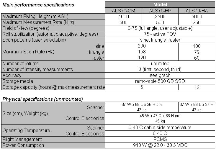
23 DMC II First LF single PAN cone system 23


24 DMC II - Next Generation Sensor Design DMC optics designed by Zeiss DMC CCD sensor designed by Dalsa 24

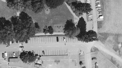
25 With the unique DMC II Sensor Design R G PA N B NIR 25
26 DMC II 230 The LF Industry Standard DMC II 230 exceeds the footprint of the first DMC by >13% Multi spectral sensor, RGB and IR 2.5:1 pan sharpened color resolution FMC forward motion compensation 2.2 second frame rate Large base/height ratio of x42 MPixel customized MSS CCD s 1x230 Mpixel customized PAN CCD 15cm GSD from ~2500m flying height 26

")
27 Medium Format Frame Camera (RCD30) Leica RCD30 27

 Stabilized lens")


 CCD made by DALSA (60")
28 Medium format for photogrammetry? Multispectral, co-registered RGB and IR Mechanical motion compensation, 2 axes >1 second frame rate two focal lengths, exhangeable (50mm, 80mm) Stabilized lens system High accuracy mapping range Exchangeable central shutter B/H ratio of 60% overlap (50mm) 2 x 60 MPx, 6um CCD for RGB and NIR CC3x can control up to five CH6x Image size single head 8956 x 6708 Image size dual head x cm 3780ft flying height (50mm) CCD made by DALSA (60 MPx) Optics made by Zeiss Weight CH6x 4 kg, CC3x 6kg 28

29 Images - FCIR 29
30 Agenda Hexagon Geosystems Z/I & Leica airborne solutions Imaging Sensors DMC & ADS & RCD30 Laser Scanning ALS 70 Outlook - Summary 30
31 Laser Scanner Leica ALS70 Product Line 31


32 What is ALS70? Various models available? 32
33 ALS70 Specifications 33


34 Leca ALS70 - Major components LS70 LP Laser Scanner SC70 System Controller LC60 Laser Controller MM70 Mass Memory OC52 Operator Display OC50 Pilot Display GI40 Guidance Indicator 34
, installed on PAV80 mount, 2 points/m 2 (~70 cm post spacing) Titel Autor 15.02.")
35 ALS70 - capabilities Intensity image, Bregenz, Germany, 11 Mar 2011, 2300 m AGL, 40 deg FOV (sine), 25 Hz scan rate, 119 khz pulse rate (MPiA), installed on PAV80 mount, 2 points/m 2 (~70 cm post spacing) Titel Autor
, 25 Hz scan rate, 500 khz pulse rate (MPiA), ~10 points/m 2, 870 m swath Titel Autor 15.02.")
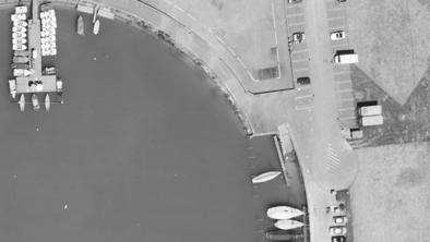
36 ALS70 - capabilities Fused class/intensity image, Fitchburg, MA (USA), September 2010, 1000 m AGL, 40 deg FOV (sine), 25 Hz scan rate, 500 khz pulse rate (MPiA), ~10 points/m 2, 870 m swath Titel Autor
37 Major new technologies in ALS70 Point Density Multiplier doubling productivity Multiple scan patterns new range counting circuitry Pulse rates closer to speed of light limit for given flying height (all models) Dual-output scanner doubles effective pulse rate and scan rate (ALS70-CM and ALS70-HP only) Laser output split into two beams (slight forward/rearward look) Dual receivers Autoscan feature monitors flying height and speed over ground & adjusts scan rate to help to keep scan patterns out-of-phase with one another Multiple scan patterns (sine, triangle and raster) for greater flexibility Increased receiver bandwidth and dynamic range, for better detection of small and/or low-reflectivity surfaces (e.g., power lines, fresh asphalt) 37
38 Single-path scanning limits along-track spacing 38
39 Dual-output scanning doubles scan rate, pulse rate 39
40 SPiA technology limits pulse rate
41 MPiA technology allows doubling of pulse rate
42 Multiple scan patterns for maximum flexibility 42


43 ALS70 family RCD30 typical mounting (2/2) 43
44 Leica ALS70 workflow From preflight to point clouds Planning Collection Ground Processing MissionPro FCMS IPAS TC IPAS CO ALS pp 44


45 Leica MissionPro ( / FPES) Flight Planning & Evaluation SW Footprint on DTM Footprint planning AOI - Block, Corridor Flight line Event (Photo) Footprint flight Flight line Event (Photo) AOI, hilly terrain Corridor, Route mode Single line, mountainous terrain 45


46 Leica FCMS - Mission Execution HW & SW (1/2) High-precision, GNSS-supported flight navigation Navigation and graphical guidance information including suggested flight path is displayed during all phases of the survey flight North-up view for project overview and to control progress in flight execution Nose-up view for optimized approach and turns In-line view for precise navigation along the line Vector map as a backdrop on North-up and Nose-up view North-up view Nose-up view In-line view 46


47 Leica FCMS - Mission Execution HW & SW (2/2) New 3-D navigation view Navigation and graphical guidance information in 3-D Optimized for corridor mapping with helicopter 3-D view during approach and turns 3-D view along the line 47
48 ALS70 workflow Planning Collection Processing MissionPro / FPES Mission Planning mode altitude scan rate FOV flight speed flight lines flight height Ground Operations GPS record DGPS base station data ALS, FCMS Airborne Operations record position and attitude data GPS IMU record scanner data range scan angle intensity timing info IPAS TC DGNSS processing IPAS TC extract position and attitude data IPAS TC trajectory processing position and attitude file real-time nav file *.SCN raw scanner files ALS Post Processor point cloud generation output formatting LDI, LAS, ASCII projection - WGS 84, UTM, state plane, Swiss, TW 97, usersupplied datum (state plane only) - NGVD 29, NAVD 88 Attune laser boresite calibration LAS file TerraScan tiling coverage verification outlier removal bare earth thinning catenary generation TerraModeller TIN/contour control report deliverables MicroStation 48
49 Leica ALS70 workflow (MFC workflow items in amber) Planning Collection Processing MissionPro / FPES Mission Planning mode altitude scan rate FOV flight speed flight lines flight height lens FL shutter speed frame rate GPS Ground Operations record DGPS base station data ALS, FCMS, RCD Airborne Operations record position and attitude data GPS IMU event marks record scanner data range scan angle intensity timing info record camera data photo ID file raw frames IPAS TC DGPS processing IPAS TC extract position and attitude data WFM Bayer conversion IPAS TC trajectory processing IPAS CO calculate exterior orientations position and attitude file real-time nav file *.SCN raw scanner files EO file ALS Post Processor point cloud generation output formatting LDI, LAS, ASCII projection - WGS 84, UTM, state plane, Swiss, TW 97, usersupplied datum (state plane only) - NGVD 29, NAVD 88 Attune laser boresite calibration WFM camera boresight, orthophoto generation LAS file orthophotos TerraScan tiling coverage verification outlier removal bare earth thinning catenary generation TerraModeller TIN/contour control report deliverables MicroStation 49
50 Agenda Hexagon Geosystems Z/I & Leica airborne solutions Imaging Sensors DMC & ADS & RCD30 Laser Scanning ALS 70 Outlook Summary 50
51 Leica & Z/I System Design Today LPS XPro T Solid LPS Frame Pro Image Station PPS Image Station PPS ADS ALS RCD DMC DMC II PAV 80 IPAS 20 FCMS FPES Mount GNSS/IMU Flight Management Flight Planning Z/I Mount POS AV 510 Z/I Inflight/Track Z/I Mission 51


52 Hexagon Airborne System Design Tomorrow DPW / Image Processing / GIS / Decision Making Frame Pro PPS XPro TerraSolid Required Data & Application Customer s Business Model Mount GNSS/IMU Flight Management Flight Planning 52
53 Dual Leica Sensor System ADS80 ALS70 53


54 Hexagon Geosystems - Airborne Technology A highly Automated Production Workflow Complete Solutions Excellent brands One Vendor 54

55 Thank you 55
Leica - Airborne Digital Sensors (ADS80, ALS60) Update / News in the context of Remote Sensing applications
 Update / News in the context of Remote Sensing applications") Luzern, Switzerland, acquired with GSD=5 cm, 2008. Leica - Airborne Digital Sensors (ADS80, ALS60) Update / News in the context of Remote Sensing applications Arthur Rohrbach, Sensor Sales Dir Europe,
Luzern, Switzerland, acquired with GSD=5 cm, 2008. Leica - Airborne Digital Sensors (ADS80, ALS60) Update / News in the context of Remote Sensing applications Arthur Rohrbach, Sensor Sales Dir Europe,
Leica ADS80 and Leica XPro - A total solution for photogrammetric mapping
 Leica ADS80 and Leica XPro - A total solution for photogrammetric mapping Ruedi Wagner, VP Imaging, Geospatial Solutions Division Phowo 2009 - Real Geospatial Solutions What else can I do with my sensor?
LIDAR Workshop IPSRS Commission 1
 LIDAR Workshop IPSRS Commission 1 2-Jul-2007, Ljubliana, Slovenia Arthur Rohrbach, Leica Geosystems, Switzerland Presentation topics 1. Basics of Airborne LIDAR Sensing Technology 2. Typical Applications
Leica ALS70. Airborne Laser Scanners Performance for diverse Applications
 Leica ALS70 Airborne Laser Scanners Performance for diverse Applications Three Models, One Result. Highest Productivity in all Applications. Imagine an affordable 500 khz pulse rate city-mapping LIDAR
Leica ALS80 Airborne Laser Scanners Performance for every Application
 Leica ALS80 Airborne Laser Scanners Performance for every Application Three Models, One Result. Highest Productivity in all Applications. Imagine an affordable city-mapping LIDAR system with an industry-leading
ISPRS Com1 Update Airborne Sensor Systems. Arthur Rohrbach SGPBF meeting, RSL, Fall 2006
 ISPRS Com1 Update Airborne Sensor Systems Arthur Rohrbach SGPBF meeting, RSL, Fall 2006 Significant Meetings / News (for Sensor Systems) 1/2 ASPRS, Reno, USA (May-06) Vexcel, Austria Leica, Switzerland
Mayden VP of Business Development Surdex Corporation
 Making Sense of Sensors Randy Mayden, Mayden VP of Business Development Surdex Corporation randym@surdex.com EARLYAERIAL PHOTOGRAPHY 2 FIRSTAERIAL CAMERA 3 AERIAL CAMERA SYSTEM DEVELOPMENT Aerial Camera
Third Rock from the Sun
 Geodesy 101 AHD LiDAR Best Practice The Mystery of LiDAR Best Practice Glenn Jones SSSi GIS in the Coastal Environment Batemans Bay November 9, 2010 Light Detection and Ranging (LiDAR) Basic principles
Leica ADS80 and Leica XPro: A Total Solution for Photogrammetric Mapping
 Photogrammetric Week '11 Dieter Fritsch (Ed.) Wichmann/VDE Verlag, Belin & Offenbach, 2011 Wagner 79 Leica ADS80 and Leica XPro: A Total Solution for Photogrammetric Mapping RUEDI WAGNER, Heerbrugg ABSTRACT
Leica Systems Overview
 RC30 AERIAL CAMERA SYSTEM Leica Systems Overview The Leica RC30 aerial film camera is the culmination of decades of development, started with Wild's first aerial camera in the 1920s. Beautifully engineered
LiDAR & Orthophoto Data Report
 LiDAR & Orthophoto Data Report Tofino Flood Plain Mapping Data collected and prepared for: District of Tofino, BC 121 3 rd Street Tofino, BC V0R 2Z0 Eagle Mapping Ltd. #201 2071 Kingsway Ave Port Coquitlam,
Terrestrial GPS setup Fundamentals of Airborne LiDAR Systems, Collection and Calibration. JAMIE YOUNG Senior Manager LiDAR Solutions
 Terrestrial GPS setup Fundamentals of Airborne LiDAR Systems, Collection and Calibration JAMIE YOUNG Senior Manager LiDAR Solutions Topics Terrestrial GPS reference Planning and Collection Considerations
Quinnipiac Post Flight Aerial Acquisition Report
 Quinnipiac Post Flight Aerial Acquisition Report August 2011 Post-Flight Aerial Acquisition and Calibration Report FEMA REGION 1 Quinnipiac Watershed, Connecticut, Massachusesetts FEDERAL EMERGENCY MANAGEMENT
ALS40 Airborne Laser Scanner
 ALS40 Airborne Laser Scanner Airborne LIDAR for Professionals High Performance Laser Scanning Direct Measurement of Ground Surface from the Air The ALS40 Airborne Laser Scanner measures the topography
The Leica Geosystems CityMapper Solution
 Photogrammetric Week '13 Dieter Fritsch (Ed.) Wichmann/VDE Verlag, Belin & Offenbach, 2013 Wagner et al. 89 The Leica Geosystems CityMapper Solution RUEDIGER WAGNER, Heerbrugg, Switzerland PETER LIECKFELDT,
Trimble Geospatial Division Integrated Solutions for Geomatics professions. Volker Zirn Regional Sales Representative
 Trimble Geospatial Division Integrated Solutions for Geomatics professions Volker Zirn Regional Sales Representative 1 Agenda Trimble GeoSpatial Division Airborne System Solutions Trimble Inpho Software
High resolution survey and orthophoto project of the Dosso-Gaya region in the Republic of Niger. by Tim Leary, Woolpert Inc.
 High resolution survey and orthophoto project of the Dosso-Gaya region in the Republic of Niger by Tim Leary, Woolpert Inc. Geospatial Solutions Photogrammetry & Remote Sensing LiDAR Professional Surveying
LiDAR data pre-processing for Ghanaian forests biomass estimation. Arbonaut, REDD+ Unit, Joensuu, Finland
 LiDAR data pre-processing for Ghanaian forests biomass estimation Arbonaut, REDD+ Unit, Joensuu, Finland Airborne Laser Scanning principle Objectives of the research Prepare the laser scanning data for
Light Detection and Ranging (LiDAR)
") Light Detection and Ranging (LiDAR) http://code.google.com/creative/radiohead/ Types of aerial sensors passive active 1 Active sensors for mapping terrain Radar transmits microwaves in pulses determines
Light Detection and Ranging (LiDAR) http://code.google.com/creative/radiohead/ Types of aerial sensors passive active 1 Active sensors for mapping terrain Radar transmits microwaves in pulses determines
Remote Sensing Sensor Integration
 Remote Sensing Sensor Integration Erica Tharp LiDAR Supervisor Table of Contents About 3001 International Inc Remote Sensing Platforms Why Sensor Integration? Technical Aspects of Sensor Integration Limitations
ixu-rs1900 Aerial Solutions
 Aerial Solutions Seeing the Large Picture Medium Format Evolves Aerial Camera Phase One 190MP Aerial Camera series is the latest Phase One innovation to offer large format metric camera functionality.
Aerial and Mobile LiDAR Data Fusion
 Creating Value Delivering Solutions Aerial and Mobile LiDAR Data Fusion Dr. Srini Dharmapuri, CP, PMP What You Will Learn About LiDAR Fusion Mobile and Aerial LiDAR Technology Components & Parameters Project
W D-0049/004 EN
 September 21, 2011 Contact Ground Survey Report, Lidar Accuracy Report, & Project Report New Madrid Seismic Zone Northeast of Memphis, Tennessee Contract Number: W91278-09D-0049/004 EN Project: C-10-026
RealWorld RealCity RealTerrain Airborne Reality Capture The Integral World of Leica Airborne Solutions
 RealWorld RealCity RealTerrain Airborne Reality Capture The Integral World of Leica Airborne Solutions Photogrammetric Week, September 11, 2017 Dr. Hartmut Rosengarten, Director Airborne Solutions EMEA,
Overview of the Trimble TX5 Laser Scanner
 Overview of the Trimble TX5 Laser Scanner Trimble TX5 Revolutionary and versatile scanning solution Compact / Lightweight Efficient Economical Ease of Use Small and Compact Smallest and most compact 3D
1. LiDAR System Description and Specifications
 High Point Density LiDAR Survey of Mayapan, MX PI: Timothy S. Hare, Ph.D. Timothy S. Hare, Ph.D. Associate Professor of Anthropology Institute for Regional Analysis and Public Policy Morehead State University
Trimble GeoSpatial Products
 Expanding Solutions for Photogrammetric and Remote Sensing Professionals 55 th Photogrammetric Week in Stuttgart September 7 th 2015 Tobias Heuchel, Trimble Stuttgart, Germany Trimble GeoSpatial Products
GEO 6895: Airborne laser scanning - workflow, applications, value. Christian Hoffmann
 GEO 6895: Airborne laser scanning - workflow, applications, value. Christian Hoffmann Agenda Why LiDAR? The value of an end-to-end workflow The Trimble AX-Series Data processing & modelling Information
Mapping Project Report Table of Contents
 LiDAR Estimation of Forest Leaf Structure, Terrain, and Hydrophysiology Airborne Mapping Project Report Principal Investigator: Katherine Windfeldt University of Minnesota-Twin cities 115 Green Hall 1530
Leica DMC III. Revolutionary CMOS technology
 Leica DMC III Breaking new ground. Always. +25,000 PIXELS World s largest swath Revolutionary CMOS technology Most efficient & intuitive workflow Based on the all-new CMOS sensor, specifically engineered
APPLICATION AND ACCURACY EVALUATION OF LEICA ADS40 FOR LARGE SCALE MAPPING
 APPLICATION AND ACCURACY EVALUATION OF LEICA ADS40 FOR LARGE SCALE MAPPING WenYuan Hu a, GengYin Yang b, Hui Yuan c,* a, b ShanXi Provincial Survey and Mapping Bureau, China - sxgcchy@public.ty.sx.cn c
The Applanix Approach to GPS/INS Integration
 Lithopoulos 53 The Applanix Approach to GPS/INS Integration ERIK LITHOPOULOS, Markham ABSTRACT The Position and Orientation System for Direct Georeferencing (POS/DG) is an off-the-shelf integrated GPS/inertial
Airborne Laser Survey Systems: Technology and Applications
 Abstract Airborne Laser Survey Systems: Technology and Applications Guangping HE Lambda Tech International, Inc. 2323B Blue Mound RD., Waukesha, WI-53186, USA Email: he@lambdatech.com As mapping products
ENY-C2005 Geoinformation in Environmental Modeling Lecture 4b: Laser scanning
 1 ENY-C2005 Geoinformation in Environmental Modeling Lecture 4b: Laser scanning Petri Rönnholm Aalto University 2 Learning objectives To recognize applications of laser scanning To understand principles
High Resolution Laserscanning, not only for 3D-City Models
 Lohr 133 High Resolution Laserscanning, not only for 3D-City Models UWE LOHR, Ravensburg ABSTRACT The TopoSys laserscanner system is designed to produce digital elevation models (DEMs) of the environment
Orthophotography and LiDAR Terrain Data Collection Rogue River, Oregon Final Report
 Orthophotography and LiDAR Terrain Data Collection Rogue River, Oregon Final Report Prepared by Sky Research, Inc. 445 Dead Indian Memorial Road Ashland, OR 97520 Prepared for Rogue Valley Council of Governments
Phone: Fax: Table of Contents
 Geomorphic Characterization of Precarious Rock Zones LIDAR Mapping Project Report Principal Investigator: David E. Haddad Arizona State University ASU School of Earth and Space
Phone: (603) Fax: (603) Table of Contents
 Fax: (603) Table of Contents") Hydrologic and topographic controls on the distribution of organic carbon in forest Soils LIDAR Mapping Project Report Principal Investigator: Adam Finkelman Plumouth State University Plymouth State University,
Hydrologic and topographic controls on the distribution of organic carbon in forest Soils LIDAR Mapping Project Report Principal Investigator: Adam Finkelman Plumouth State University Plymouth State University,
Geometry of Aerial photogrammetry. Panu Srestasathiern, PhD. Researcher Geo-Informatics and Space Technology Development Agency (Public Organization)
") Geometry of Aerial photogrammetry Panu Srestasathiern, PhD. Researcher Geo-Informatics and Space Technology Development Agency (Public Organization) Image formation - Recap The geometry of imaging system
Geometry of Aerial photogrammetry Panu Srestasathiern, PhD. Researcher Geo-Informatics and Space Technology Development Agency (Public Organization) Image formation - Recap The geometry of imaging system
Leica ALS70-HA High-Altitude Airborne LIDAR Product Specifications
 Leica ALS70-HA High-Altitude Airborne LIDAR Overview ALS70-HA is a compact laser-based system designed for the acquisition of high-density topographic and return signal intensity data from a variety of
ifp Universität Stuttgart Performance of IGI AEROcontrol-IId GPS/Inertial System Final Report
 Universität Stuttgart Performance of IGI AEROcontrol-IId GPS/Inertial System Final Report Institute for Photogrammetry (ifp) University of Stuttgart ifp Geschwister-Scholl-Str. 24 D M. Cramer: Final report
Airborne LiDAR Data Acquisition for Forestry Applications. Mischa Hey WSI (Corvallis, OR)
") Airborne LiDAR Data Acquisition for Forestry Applications Mischa Hey WSI (Corvallis, OR) WSI Services Corvallis, OR Airborne Mapping: Light Detection and Ranging (LiDAR) Thermal Infrared Imagery 4-Band
Airborne LiDAR Data Acquisition for Forestry Applications Mischa Hey WSI (Corvallis, OR) WSI Services Corvallis, OR Airborne Mapping: Light Detection and Ranging (LiDAR) Thermal Infrared Imagery 4-Band
LiDAR Remote Sensing Data Collection: Yaquina and Elk Creek Watershed, Leaf-On Acquisition
 LiDAR Remote Sensing Data Collection: Yaquina and Elk Creek Watershed, Leaf-On Acquisition Submitted by: 4605 NE Fremont, Suite 211 Portland, Oregon 97213 April, 2006 Table of Contents LIGHT DETECTION
Leica PAV30. Gyro-Stabilized Camera Mount
 Leica PAV0 Gyro-Stabilized Camera Mount Leica PAV0 High Quality Aerial Photography The Leica PAV0 gyro-stabilized mount has been developed by Leica Geosystems aerial camera engineers for compensation of
P h a s e O n e i X U - RS A c c u r a c y A n a l y s i s. T h e f o r e f r o n t o f a e r i a l p h o t o g r a p h y
 P h a s e O n e i X U - RS1 0 0 0 A c c u r a c y A n a l y s i s T h e f o r e f r o n t o f a e r i a l p h o t o g r a p h y 1 Phase One Industrial Aerial Survey Products ixu-rs1000, ixu1000 series
G2-AS100. Presents: A mid-format fully integrated photogrammetric camera
 Presents: G2-AS100 A mid-format fully integrated photogrammetric camera Designed and manufactured by Global Geo Supplies, Inc. Lone Tree, Colorado USA 1 TABLE OF CONTENTS CAMERA SPECIFICATIONS LENSES PERFORMANCE
HAWAII KAUAI Survey Report. LIDAR System Description and Specifications
 HAWAII KAUAI Survey Report LIDAR System Description and Specifications This survey used an Optech GEMINI Airborne Laser Terrain Mapper (ALTM) serial number 06SEN195 mounted in a twin-engine Navajo Piper
AIRBORNE LIDAR TASK ORDER REPORT SHELBY COUNTY TN 1M NPS LIDAR/FEATURE EXTRACT TASK ORDER UNITED STATES GEOLOGICAL SURVEY (USGS)
") AIRBORNE LIDAR TASK ORDER REPORT SHELBY COUNTY TN 1M NPS LIDAR/FEATURE EXTRACT TASK ORDER UNITED STATES GEOLOGICAL SURVEY (USGS) CONTRACT NUMBER: G10PC00057 TASK ORDER NUMBER: G12PD00127 Woolpert Project
AIRBORNE LIDAR TASK ORDER REPORT SHELBY COUNTY TN 1M NPS LIDAR/FEATURE EXTRACT TASK ORDER UNITED STATES GEOLOGICAL SURVEY (USGS) CONTRACT NUMBER: G10PC00057 TASK ORDER NUMBER: G12PD00127 Woolpert Project
Accuracy Assessment of POS AVX 210 integrated with the Phase One ixu150
 White Paper 3/17/2016 Accuracy Assessment of POS AVX 210 integrated with the Phase One ixu150 Omer Mian, Joe Hutton, Greg Lipa, James Lutes, Damir Gumerov, Srdjan Sobol Applanix, William Chan - GeoPixel
Yosemite National Park LiDAR Mapping Project Report
 Yosemite National Park LiDAR Mapping Project Report Feb 1, 2011 Principal Investigator: Greg Stock, PhD, PG Resources Management and Science Yosemite National Park 5083 Foresta Road, PO Box 700 El Portal,
Product Description. Leica RC30 Aerial Camera System. Overview
 Leica RC30 Aerial Camera System Overview The Leica RC30 is an aerial film camera system of top quality and performance, capable of acquiring the very best aerial photographs with black and white, color
Integrated Multi-Source LiDAR and Imagery
 Figure 1: AirDaC aerial scanning system Integrated Multi-Source LiDAR and Imagery The derived benefits of LiDAR scanning in the fields of engineering, surveying, and planning are well documented. It has
Light Detection and Ranging (LiDAR) Radiohead House of Cards
 Radiohead House of Cards") Light Detection and Ranging (LiDAR) Radiohead House of Cards http://the-moni-blog.blogspot.com/2009/03/lidar-is-going-mainstream-mtv-baby.html h =? Laser Vision GPS + IMU θ H X a h Types of aerial sensors
Light Detection and Ranging (LiDAR) Radiohead House of Cards http://the-moni-blog.blogspot.com/2009/03/lidar-is-going-mainstream-mtv-baby.html h =? Laser Vision GPS + IMU θ H X a h Types of aerial sensors
THE INTERIOR AND EXTERIOR CALIBRATION FOR ULTRACAM D
 THE INTERIOR AND EXTERIOR CALIBRATION FOR ULTRACAM D K. S. Qtaishat, M. J. Smith, D. W. G. Park Civil and Environment Engineering Department, Mu ta, University, Mu ta, Karak, Jordan, 61710 khaldoun_q@hotamil.com
CCNS and AEROcontrol: Products for Efficient Photogrammetric Data Collection
 'Photogrammetric Week 01' D. Fritsch & R. Spiller, Eds. Wichmann Verlag, Heidelberg 2001. Kremer 85 CCNS and AEROcontrol: Products for Efficient Photogrammetric Data Collection JENS KREMER, Kreuztal ABSTRACT
SPAR, ELMF 2013, Amsterdam. Laser Scanning on the UK Highways Agency Network. Hamish Grierson Blom Uk
 SPAR, ELMF 2013, Amsterdam Laser Scanning on the UK Highways Agency Network Hamish Grierson Blom Uk www.blomasa.com www.blom-uk.co.uk Blom UK Part of the Blom Group Blom Group - Europe s largest aerial
Project Report Nooksack South Fork Lummi Indian Nation. Report Presented to:
 June 5, 2005 Project Report Nooksack South Fork Lummi Indian Nation Contract #2291-H Report Presented to: Lummi Indian Nation Natural Resources Department 2616 Kwina Road Bellingham, WA 98226 Point of
Lidar Technical Report
 Lidar Technical Report Oregon Department of Forestry Sites Presented to: Oregon Department of Forestry 2600 State Street, Building E Salem, OR 97310 Submitted by: 3410 West 11st Ave. Eugene, OR 97402 April
Leica ALS Corridor Mapper Airborne Laser Corridor Mapper Product Specifications
 Airborne Laser Corridor Mapper Overview ALS Corridor Mapper is a compact laser-based system designed for the acquisition of topographic and return signal intensity data from a variety of airborne platforms.
LiDAR Remote Sensing Data Collection: Salmon River Study Area, Oregon
 LiDAR Remote Sensing Data Collection: Salmon River Study Area, Oregon Submitted to: Barbara Ellis-Sugai USDA Forest Service Siuslaw National Forest 4077 SW Research Way Corvallis, Oregon 541.750.7056 Submitted
Iowa Department of Transportation Office of Design. Photogrammetric Mapping Specifications
 Iowa Department of Transportation Office of Design Photogrammetric Mapping Specifications March 2015 1 Purpose of Manual These Specifications for Photogrammetric Mapping define the standards and general
AN INTEGRATED SENSOR ORIENTATION SYSTEM FOR AIRBORNE PHOTOGRAMMETRIC APPLICATIONS
 AN INTEGRATED SENSOR ORIENTATION SYSTEM FOR AIRBORNE PHOTOGRAMMETRIC APPLICATIONS M. J. Smith a, *, N. Kokkas a, D.W.G. Park b a Faculty of Engineering, The University of Nottingham, Innovation Park, Triumph
2. POINT CLOUD DATA PROCESSING
 Point Cloud Generation from suas-mounted iphone Imagery: Performance Analysis A. D. Ladai, J. Miller Towill, Inc., 2300 Clayton Road, Suite 1200, Concord, CA 94520-2176, USA - (andras.ladai, jeffrey.miller)@towill.com
Lewis County Public Works Department (County) GIS Mapping Division 350 N. Market Blvd. Chehalis, WA Phone: Fax:
 GIS Mapping Division 350 N. Market Blvd. Chehalis, WA Phone: Fax:") March 31, 2005 Project Report Lewis County, WA Contract #2262-H Report Presented to: Lewis County Public Works Department (County) GIS Mapping Division 350 N. Market Blvd. Chehalis, WA 98532-2626 Phone:
March 31, 2005 Project Report Lewis County, WA Contract #2262-H Report Presented to: Lewis County Public Works Department (County) GIS Mapping Division 350 N. Market Blvd. Chehalis, WA 98532-2626 Phone:
Trends in Digital Aerial Acquisition Systems
 Trends in Digital Aerial Acquisition Systems Ernest Yap Regional Sales Manager, Airborne-Americas eyap@applanix.com 1 Medium Format Digital Cameras Medium Format Digital Cameras Where does the Medium
Redefining Airborne LiDAR Introduction to RIEGL LMS in Airborne LiDAR
 Redefining Airborne LiDAR Introduction to RIEGL LMS in Airborne LiDAR Andres Vargas Integration Systems Engineer LAGF Mexico City, Mexico September 23th, 2014 1 Airborne Laser Scanning History and Evolution
A MULTI-SENSOR APPROACH TO SEMI-GLOBAL MATCHING
 A MULTI-SENSOR APPROACH TO SEMI-GLOBAL MATCHING S. Gehrke a, M. Downey a, R. Uebbing a, J. Welter a, W. LaRocque b a North West Geomatics Ltd., Suite 212, 5438-11 th Street NE, Calgary, Alberta, T2E 7E9,
Leica Geosystems UAS Airborne Sensors. MAPPS Summer Conference July 2014 Alistair Stuart
 Leica Geosystems UAS Airborne Sensors MAPPS Summer Conference July 2014 Alistair Stuart 1 Sensors for UAS! Promise of UAS is to expand aerial data acquisition capabilities for traditional and non-traditional
An Introduction to Lidar & Forestry May 2013
 An Introduction to Lidar & Forestry May 2013 Introduction to Lidar & Forestry Lidar technology Derivatives from point clouds Applied to forestry Publish & Share Futures Lidar Light Detection And Ranging
APPLANIX DIRECT GEOREFERENCING FOR AIRBORNE MAPPING. and FLIGHT MANAGEMENT SYSTEMS. The Better Way to Reduce the Cost of Airborne Mapping
 APPLANIX DIRECT GEOREFERENCING and FLIGHT MANAGEMENT SYSTEMS FOR AIRBORNE MAPPING The Better Way to Reduce the Cost of Airborne Mapping capture everything. precisely. Applanix Direct Georeferencing and
Hardware 3D Mapping Systems
 Hardware 3D Mapping Systems About Us GreenValley International GreenValley International provides 3D mapping solutions that include mobile & aerial LiDAR acquisition hardware, post-processing software
Photo based Terrain Data Acquisition & 3D Modeling
 Photo based Terrain Data Acquisition & 3D Modeling June 7, 2013 Howard Hahn Kansas State University Partial funding by: KSU Office of Research and Sponsored Programs Introduction: Need Application 1 Monitoring
Simulating Dynamic Hydrological Processes in Archaeological Contexts Mapping Project Report
 Simulating Dynamic Hydrological Processes in Archaeological Contexts Mapping Project Report Principal Investigator: Wetherbee Dorshow University of New Mexico 15 Palacio Road Santa Fe, NM 87508 e-mail:
LiDAR REMOTE SENSING DATA COLLECTION BISCUIT FIRE STUDY AREA, OREGON
 LiDAR REMOTE SENSING DATA COLLECTION BISCUIT FIRE STUDY AREA, OREGON Oblique view in the Biscuit Fire Study Area: Above Ground ESRI Grid (1-meter resolution) derived from all LiDAR points Submitted to:
Quantifying the Geomorphic and Sedimentological Responses to Dam Removal. Mapping Project Report
 Quantifying the Geomorphic and Sedimentological Responses to Dam Removal. Mapping Project Report January 21, 2011 Principal Investigator: John Gartner Dartmouth College Department of Earth Sciences Hanover,
SimActive and PhaseOne Workflow case study. By François Riendeau and Dr. Yuri Raizman Revision 1.0
 SimActive and PhaseOne Workflow case study By François Riendeau and Dr. Yuri Raizman Revision 1.0 Contents 1. Introduction... 2 1.1. Simactive... 2 1.2. PhaseOne Industrial... 2 2. Testing Procedure...
Producing Ortho Imagery In ArcGIS. Hong Xu, Mingzhen Chen, Ringu Nalankal
 Producing Ortho Imagery In ArcGIS Hong Xu, Mingzhen Chen, Ringu Nalankal Agenda Ortho imagery in GIS ArcGIS ortho mapping solution Workflows - Satellite imagery - Digital aerial imagery - Scanned imagery
MODELLING FOREST CANOPY USING AIRBORNE LIDAR DATA
 MODELLING FOREST CANOPY USING AIRBORNE LIDAR DATA Jihn-Fa JAN (Taiwan) Associate Professor, Department of Land Economics National Chengchi University 64, Sec. 2, Chih-Nan Road, Taipei 116, Taiwan Telephone:
Mapping Project Report Table of Contents
 Beavers as geomorphic agents in small, Rocky Mountain streams. Mapping Project Report Jan 27, 2011 Principal Investigator: Rebekah Levine Department of Earth and Planetary Sciences, MSCO3-2040,1 University
Lidar Sensors, Today & Tomorrow. Christian Sevcik RIEGL Laser Measurement Systems
 Lidar Sensors, Today & Tomorrow Christian Sevcik RIEGL Laser Measurement Systems o o o o Online Waveform technology Stand alone operation no field computer required Remote control through wireless network
RIEGL LMS-Q780. The Versatile, High Altitude Airborne LIDAR Sensor
 RIEGL LMS-Q780 4700m 400kHz The full waveform airborne laser scanner offers great versatility, accuracy, and data quality. The scanner enables you to successfully deliver your projects with industry leading
Drone2Map: an Introduction. October 2017
 Drone2Map: an Introduction October 2017 Drone2Map: An Introduction Topics: - Introduction to Drone Mapping - Coordinate Systems - Overview of Drone2Map - Basic Drone2Map Workflow - 2D Data Processing -
Data structure on storage discs ADS40_1 (left) and ADS40_2 (right)
 and ADS40_2 (right)") EuroSDR network Digital Camera Calibration Michael Cramer Institute for Photogrammetry (ifp) University of Stuttgart Geschwister-Scholl-Str. 24D D-70174 Stuttgart/Germany Stuttgart, April 06, 2006 Phase
EuroSDR network Digital Camera Calibration Michael Cramer Institute for Photogrammetry (ifp) University of Stuttgart Geschwister-Scholl-Str. 24D D-70174 Stuttgart/Germany Stuttgart, April 06, 2006 Phase
Up to 4 range measurements per pulse, including last 4 Intensity readings with 12-bit dynamic range for each measurement
 Project PI: Hugo A. Gutierrez Jurado 1. ALTM Specifications This survey used an Optech GEMINI Airborne Laser Terrain Mapper (ALTM) serial number 06SEN195 mounted in a twin-engine Cessna Skymaster (Tail
ADS40 Calibration & Verification Process. Udo Tempelmann*, Ludger Hinsken**, Utz Recke*
 ADS40 Calibration & Verification Process Udo Tempelmann*, Ludger Hinsken**, Utz Recke* *Leica Geosystems GIS & Mapping GmbH, Switzerland **Ludger Hinsken, Author of ORIMA, Konstanz, Germany Keywords: ADS40,
2/9/2016. Session Agenda: Implementing new Geospatial Technologies for more efficient data capture
 Implementing new Geospatial Technologies for more efficient data capture Jay Haskamp Applied Geospatial Engineer Steve Richter VP Sales Session Agenda: Today s changing technologies and what lies ahead
2010 LiDAR Project. GIS User Group Meeting June 30, 2010
 2010 LiDAR Project GIS User Group Meeting June 30, 2010 LiDAR = Light Detection and Ranging Technology that utilizes lasers to determine the distance to an object or surface Measures the time delay between
LiDAR Technical Report NE Washington LiDAR Production 2017
 LiDAR Technical Report NE Washington LiDAR Production 2017 Presented to: Washington DNR 1111 Washington Street SE Olympia, Washington 98504 Submitted by: 860 McKinley St Eugene, OR 97402 July 26, 2017
Chapter 1: Overview. Photogrammetry: Introduction & Applications Photogrammetric tools:
 Chapter 1: Overview Photogrammetry: Introduction & Applications Photogrammetric tools: Rotation matrices Photogrammetric point positioning Photogrammetric bundle adjustment This chapter will cover the
Terrain Modeling and Mapping for Telecom Network Installation Using Scanning Technology. Maziana Muhamad
 Terrain Modeling and Mapping for Telecom Network Installation Using Scanning Technology Maziana Muhamad Summarising LiDAR (Airborne Laser Scanning) LiDAR is a reliable survey technique, capable of: acquiring
2-in-1 Large Format and Oblique Aerial Camera Systems for 3D Urban Mapping. Philipp Grimm EUROSDR/ISPRS Workshop Oblique, Barcelona,
 2-in-1 Large Format and Oblique Aerial Camera Systems for 3D Urban Mapping Philipp Grimm EUROSDR/ISPRS Workshop Oblique, Barcelona, 09.10.2017 Mission Planning & Flight Guidance Sensor Management GNSS/IMU
RIEGL LMS-Q780. The Versatile, High Altitude Airborne LIDAR Sensor
 RIEGL LMS-Q780 3050m 400kHz The full waveform airborne laser scanner offers great versatility, accuracy, and data quality. The scanner enables you to successfully deliver your projects with industry leading
ICC experiences on Inertial / GPS sensor orientation. A. Baron, W.Kornus, J.Talaya Institut Cartogràfic de Catalunya, ICC
 ICC experiences on Inertial / GPS sensor orientation A. Baron, W.Kornus, J.Talaya Institut Cartogràfic de Catalunya, ICC Keywords: GPS/INS orientation, robustness Abstract In the last few years the photogrammetric
LIDAR REMOTE SENSING DATA COLLECTION: DOGAMI, CAMP CREEK PROJECT AREA
 LIDAR REMOTE SENSING DATA COLLECTION DEPARTMENT OF GEOLOGY AND MINERAL INDUSTRIES CAMP CREEK, OREGON NOVEMBER 26, 2008 Submitted to: Department of Geology and Mineral Industries 800 NE Oregon Street, Suite
3-d rendering of LiDAR points with RGB color assigned from ortho-photos, view of Lostine River looking south
 LIDAR AND TRUE-COLOR ORTHOPHOTOGRAPHS AIRBORNE DATA ACQUISITION AND PROCESSING: GRANDE RONDE AND LEMHI RIVER BASINS Submitted to: Lanie Paquin; Susan Fraser U.S. Bureau of Reclamation 1150 N. Curtis Road
Assessing the Performance of Different Direct-Georeferencing with Large Format Digital Cameras
 Assessing the Performance of Different Direct-Georeferencing with Large Format Digital Cameras Civil and Environment Engineering Department, Mu ta University, Mu ta, Al-Karak, Jordan, 61710. E.mail: khaldoun_q@hotamil.com
trimble unmanned aircraft systems
 trimble unmanned aircraft systems FOR SURVEYING and MAPPING TRIMBLE UAS AERIAL IMAGING solution: INDUSTRY-LEADING UAS MAPPING SOLUTIONS FOR ALL YOUR APPLICATION NEEDS Trimble prides itself on being a leader
9/14/2011. Contents. Lecture 3: Spatial Data Acquisition in GIS. Dr. Bo Wu Learning Outcomes. Data Input Stream in GIS
 Contents Lecture 3: Spatial Data Acquisition in GIS Dr. Bo Wu lsbowu@polyu.edu.hk 1. Learning outcomes. Data acquisition: Manual digitization 3. Data acquisition: Field survey 4. Data acquisition: Remote
Sasanka Madawalagama Geoinformatics Center Asian Institute of Technology Thailand
 Sasanka Madawalagama Geoinformatics Center Asian Institute of Technology Thailand This learning material was not prepared by ADB. The views expressed in this document are the views of the author/s and
Technical Considerations and Best Practices in Imagery and LiDAR Project Procurement
 Technical Considerations and Best Practices in Imagery and LiDAR Project Procurement Presented to the 2014 WV GIS Conference By Brad Arshat, CP, EIT Date: June 4, 2014 Project Accuracy A critical decision