P h a s e O n e i X U - RS A c c u r a c y A n a l y s i s. T h e f o r e f r o n t o f a e r i a l p h o t o g r a p h y
|
|
|
- Griffin Smith
- 5 years ago
- Views:
Transcription

1 P h a s e O n e i X U - RS A c c u r a c y A n a l y s i s T h e f o r e f r o n t o f a e r i a l p h o t o g r a p h y 1


2 Phase One Industrial Aerial Survey Products ixu-rs1000, ixu1000 series ixu-rs1900 Phase One 190MP Aerial System Phase One 50MP-100MP with DJI M600 2
3 Phase One Industrial Cameras ixu-rs1000 series ixu-rs1000 series Camera Type ixu-rs1000 Camera Specifications Lens type Rodenstock / Schneider-Kreuznach Focal length F (mm) RS lenses: 32, 40, 50, 70, 90, 110, 150 SK lenses: 28, 55, 80, 110, 150, 240 FOV (across line, deg) 86.5 (28mm) 12.9 (240mm) FOV (along flight line, deg) 70.3 (28mm) 9.7 (240mm) Aperture f/5.6 Exposure principle Leaf shutter Exposure (sec) 1/2000 to 1/125 Image capture rate 1 frame every 0.6 sec Light Sensitivity (ISO) Dynamic Range (db) >84 Spectral characteristics R,G,B Sensor Specifications CMOS pixel size (µm) 4.6 CMOS array (pix) 11,608 x 8,708 Analog-to-digital-conversion (bit) 14 Frame / Image Specifications Frame geometry Central projection Image size (pixel) 11,608 x 8,708 Image volume (MP) 100 Color RGB or NIR Typical image size (MB) 300 Image format Phase One RAW, TIFF, JPEG Operational Specifications Power Consumption < 10W Dimensions (depends on lens) 97.4 x 93 x <218 mm Weight (depends on lens) < 2 kg 3
 45.7 / 33.0 Aperture f/5.6 Exposure principle Leaf shutter Exposure (sec) 1/2000 to 1/125 Image capture rate 1 frame every 0.")
4 Phase One 190MP Aerial System Specifications Phase One 190MP Aerial System Camera Type ixu-rs1900 ixu-rs band Camera Specifications Lenses type Rodenstock Number of lenses 2 3 Focal length (mm) & 50 FOV (across / along flight line, deg) 45.7 / 33.0 Aperture f/5.6 Exposure principle Leaf shutter Exposure (sec) 1/2000 to 1/125 Image capture rate 1 frame every 0.6 sec Light Sensitivity (ISO) Dynamic Range (db) >84 Spectral characteristics R,G,B R,G,B, NIR Sensor Specifications CMOS pixel size (µm) 4.6 CMOS array (pix) 11,608 x 8,708 Analog-to-digital-conversion (bit) 14 Frame / Image Specifications Frame geometry Central projection Image size (pixel) 16,470 x 11,570 Image volume (MP) 190 Color RGB RGB, NIR, CIR, 4-band Pansharpen ratio N/A 1:1.8 Typical image size (MB) Image format Phase One RAW, TIFF, JPEG Complete Set ix Controller up to 6 separate USB3 ports Pilot monitor for navigation Yes Operator monitor for camera management Yes Gyro-stabilizer SOMAG DSM400 INS/GNSS Applanix, NovAtel, Operational Specifications Power Consumption 180 W Dimensions (L x W x H) 46x43x37 cm Weight 30 kg 4
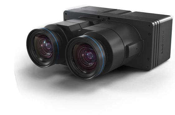


5 Phase One ixu-rs1900 Image Formation Principles ixu-rs1900 5
6 Flight time (min) Distance between flight lines (m) Phase One ixu-rs1900 vs ixu-rs1000 productivity comparison Distance between flight lines ixu-rs1900 ixu-rs1000 Total flight time (including turns) required for capturing an area of 5km by 5km (25 km²) with 5cm ground resolution GSD ixu-rs1900 increases the distance between flight lines on 63% Flight time 47 ixu-rs1900 ixu-rs GSD 6

7 Phase One Industrial Test Field Area Test field characteristics WE 2.0 km SN 1.2 km Number of GCPs 53 GCPs RMSxy GCPs RMSz ± 0.8 cm ± 1.3 cm GCPs measurements procedure: Well-defined manmade features selected as GCPs 1. The geodetic observations were made according to static GPS survey procedure with one reference station. 2. The reference station was measured against CSAR permanent GPS station by two independent 1-hour long observation sessions. 3. Every GCP was measured by two independent half-hour long observation sessions. 7


8 Aerial Survey flight with ixu-rs1000/90 Flight characteristics Flight altitude GSD Distance between strips 2,500 feet 4 cm 230 m Side overlap 49% Forward overlap 80% Frame size 450m x 340m Orthophoto angle 17 Cessna 172 Building lean 15% Ground speed 100 knot Strips SN 9 Strips WE 2 Number of images 202 8
 dx 5 GCP 48 Check Points dy dz dx dy dxy dz MIN -0.4-0.5-0.3-5.9-7.2 9.3-11.5 MAX 0.4 1.1 0.2 3.9 4.6 6.0 7.4 Mean 0.0 0.0 0.0 0.1-1.1 1.2-2.6 STDEV 0.3 0.6 0.2 1.")
9 Accuracy analysis: 5 GCP and 48 Check Points Block accuracy on Check Points RMSxy = ± 2.9 cm (0.7 pix) RMSz = ± 6.0 cm (1.5 pix) dx 5 GCP 48 Check Points dy dz dx dy dxy dz MIN MAX Mean STDEV RMS
 dx 9 GCP 44 Check Points dy dz dx dy dxy dz MIN -0.7-0.5-0.2-5.8-6.9 9.0-10.6 MAX 0.6 1.4 0.2 3.5 4.8 5.9 10.7 Mean 0.0 0.0 0.0 0.3-0.8 0.9-0.7 STDEV 0.4 0.6 0.1 1.")
10 Accuracy analysis: 9 GCP and 44 Check Points Block accuracy on Check Points RMSxy = ± 2.7 cm (0.7 pix) RMSz = ± 5.1 cm (1.3 pix) dx 9 GCP 44 Check Points dy dz dx dy dxy dz MIN MAX Mean STDEV RMS
 dx 15 GCP 38 Check Points dy dz dx dy dxy dz MIN -0.8-1.2-0.2-6.3-6.2 8.8-8.1 MAX 0.6 1.8 0.2 3.3 5.9 6.8 5.3 Mean 0.0 0.0 0.0-0.3 0.1 0.3-1.8 STDEV 0.4 0.6 0.1 1.")
11 Accuracy analysis: 15 GCP and 38 Check Points Block accuracy on Check Points RMSxy = ± 2.7 cm (0.7 pix) RMSz = ± 4.4 cm (1.1 pix) dx 15 GCP 38 Check Points dy dz dx dy dxy dz MIN MAX Mean STDEV RMS

12 Accuracy analysis: summary GCP = 5; Check Points = 48 RMSxy 2.9 cm 0.7 pix RMSz 6.0 cm 1.5 pix GCP = 9; Check Points = 44 RMSxy 2.7 cm 0.7 pix RMSz 5.1 cm 1.3 pix GCP = 15; Check Points = 38 RMSxy 2.7 cm 0.7 pix RMSz 4.4 cm 1.1 pix 1. The planimetric accuracy of the block on Check Points is always at the level of 0.7 pixel independently on the number and configuration of GCPs. 2. The altimetric accuracy of the block on Check Points starts from 6 cm (1.5 pix) with 5 GCPs and reaches 4.4 cm (1.1 pix) with 15 GCPs. 3. The altimetric accuracy is considered as high accuracy and even may be improved by use of high accuracy GPS data. 12


13 Phase One ixu-rs1000 camera distortion model 1. The distortion model of the camera ixu-rs1000 with 90 mm focal length fully corresponds to a standard Brown-Conrady symmetric radial distortion model. 2. Images captured with the camera may be easily transformed to undistorted model with a maximal residual less than 1 µm. 13

14 Thank You 14
SimActive and PhaseOne Workflow case study. By François Riendeau and Dr. Yuri Raizman Revision 1.0
 SimActive and PhaseOne Workflow case study By François Riendeau and Dr. Yuri Raizman Revision 1.0 Contents 1. Introduction... 2 1.1. Simactive... 2 1.2. PhaseOne Industrial... 2 2. Testing Procedure...
ixu-rs1900 Aerial Solutions
 Aerial Solutions Seeing the Large Picture Medium Format Evolves Aerial Camera Phase One 190MP Aerial Camera series is the latest Phase One innovation to offer large format metric camera functionality.
G2-AS100. Presents: A mid-format fully integrated photogrammetric camera
 Presents: G2-AS100 A mid-format fully integrated photogrammetric camera Designed and manufactured by Global Geo Supplies, Inc. Lone Tree, Colorado USA 1 TABLE OF CONTENTS CAMERA SPECIFICATIONS LENSES PERFORMANCE
PHASEONE 190MP AERIAL SYSTEM: CAMERA DESIGN PRINCIPLES AND PRODUCTIVITY ANALYSIS LOTNICZY SYSTEM 190 MP: KONSTRUKCJA KAMERY I ANALIZA JEJ WYDAJNOŚCI
 Archiwum Fotogrametrii, Kartografii i Teledetekcji, vol. 29, pp. 137-146 ISSN 2083-2214, eissn 2391-9477 DOI: 10.14681/afkit.2017.010 PHASEONE 190MP AERIAL SYSTEM: CAMERA DESIGN PRINCIPLES AND PRODUCTIVITY
P H A S E O N E I N D U S T R I A L. T h e w o r l d l e a d e r i n h i g h r e s o l u t i o n i m a g i n g
 P H A S E O N E I N D U S T R I A L T h e w o r l d l e a d e r i n h i g h r e s o l u t i o n i m a g i n g 1 WE ARE A WORLD LEADING PROVIDER of medium format digital imaging systems and solutions for
Accuracy Assessment of POS AVX 210 integrated with the Phase One ixu150
 White Paper 3/17/2016 Accuracy Assessment of POS AVX 210 integrated with the Phase One ixu150 Omer Mian, Joe Hutton, Greg Lipa, James Lutes, Damir Gumerov, Srdjan Sobol Applanix, William Chan - GeoPixel
Phase One ixa-r-180 Aerial Triangulation
 Phase One ixa-r-180 Aerial Triangulation Accuracy Assessment Results Revision 1 Oodi Menaker and Stephen Epstein Table of Contents 1. Introduction... 1 2. Method... 1 2.1. Selection of Test Area... 2 2.2.
Phase One ixa-r Camera. Fully Integrated Aerial Photography Solutions
 Phase One ixa-r Camera Fully Integrated Aerial Photography Solutions Phase One ixa-r Camera System The Phase One ixa-r aerial camera system is an integrated medium format camera system that was designed
2-in-1 Large Format and Oblique Aerial Camera Systems for 3D Urban Mapping. Philipp Grimm EUROSDR/ISPRS Workshop Oblique, Barcelona,
 2-in-1 Large Format and Oblique Aerial Camera Systems for 3D Urban Mapping Philipp Grimm EUROSDR/ISPRS Workshop Oblique, Barcelona, 09.10.2017 Mission Planning & Flight Guidance Sensor Management GNSS/IMU
Product Description. Leica RC30 Aerial Camera System. Overview
 Leica RC30 Aerial Camera System Overview The Leica RC30 is an aerial film camera system of top quality and performance, capable of acquiring the very best aerial photographs with black and white, color
Photogrammetric Performance of an Ultra Light Weight Swinglet UAV
 Photogrammetric Performance of an Ultra Light Weight Swinglet UAV J. Vallet, F. Panissod, C. Strecha, M. Tracol UAV-g 2011 - Unmanned Aerial Vehicle in Geomatics September 14-16, 2011ETH Zurich Summary
UAV Hyperspectral system for remote sensing application
 UAV Hyperspectral system for remote sensing application The system consists airborne imaging spectrophotometer placed on a frame suitable for use aircraft, a UAV helicopter and all components needed for
REMOTE SENSING LiDAR & PHOTOGRAMMETRY 19 May 2017
 REMOTE SENSING LiDAR & PHOTOGRAMMETRY 19 May 2017 SERVICES Visual Inspections Digital Terrain Models Aerial Imagery Volume Computations Thermal Inspections Photo maps Aerial Video Training & Consultancy
Newest Technologies for Compact Aerial Survey Cameras
 Newest Technologies for Compact Aerial Survey Cameras Tobias Tölg CEO t.toelg@rollei-metric.com RolleiMetric Systempartner of - Rollei Metric GmbH - AIC History and Present - AICxN - Conclusion and Prospects
P/N: FLIR Aerial Commercial Building Inspector Kit (30 Hz) Other output formats Social media
 Other output formats Social media") Page 1 of 7 Other output formats Social media Click here to refresh the page Rev. 35005 Last modified 2016-04-15 Additional supporting documents: Mechanical drawings P/N: 75604-0404 FLIR Aerial Commercial
Page 1 of 7 Other output formats Social media Click here to refresh the page Rev. 35005 Last modified 2016-04-15 Additional supporting documents: Mechanical drawings P/N: 75604-0404 FLIR Aerial Commercial
Quality Report Generated with version
 Quality Report Generated with version 1.3.54 Important: Click on the different icons for: Help to analyze the results in the Quality Report Additional information about the feature Click here for additional
Chapters 1 9: Overview
 Chapters 1 9: Overview Chapter 1: Introduction Chapters 2 4: Data acquisition Chapters 5 9: Data manipulation Chapter 5: Vertical imagery Chapter 6: Image coordinate measurements and refinements Chapters
Phase One Industrial Fully Integrated Drone Solution
 Phase One Industrial Fully Integrated Drone Solution Fully Integrated Drone Solution The use of drones and UAV-based platforms in the aerial imaging market is increasing rapidly, and remote sensing is
Phase One ixu 150 The world s smallest and lightest integrated digital medium format aerial camera
 Phase One ixu 150 The world s smallest and lightest integrated digital medium format aerial camera Phase One ixu 150 Camera System The Phase One ixu 150 camera is the smallest and lightest integrated digital
XF Camera Systems Technical Specifications
 XF Camera Systems Imaging Sensor Imaging Sensors Digital Back Options Backwards Compatibility IQ3 50-80MP & IQ1 40-80MP with XF mounts (See specification for Digital Backs) IQ1 & IQ2 with P mounts Controls
 S-series USB Ø 2.75 ix, FOV ~ 120 83-0001-01 S-series USB Ø 2.75 ix, FOV ~ 45 83-0001-02 S-series USB Ø 3.2 Alu, FOV ~ 120 83-0002-01 S-series USB Ø 3.2 Alu, FOV ~ 45 83-0002-02 Ø2.75x24 mm or Ø3.2x22
Leica Systems Overview
 RC30 AERIAL CAMERA SYSTEM Leica Systems Overview The Leica RC30 aerial film camera is the culmination of decades of development, started with Wild's first aerial camera in the 1920s. Beautifully engineered
Leica - Airborne Digital Sensors (ADS80, ALS60) Update / News in the context of Remote Sensing applications
 Update / News in the context of Remote Sensing applications") Luzern, Switzerland, acquired with GSD=5 cm, 2008. Leica - Airborne Digital Sensors (ADS80, ALS60) Update / News in the context of Remote Sensing applications Arthur Rohrbach, Sensor Sales Dir Europe,
Luzern, Switzerland, acquired with GSD=5 cm, 2008. Leica - Airborne Digital Sensors (ADS80, ALS60) Update / News in the context of Remote Sensing applications Arthur Rohrbach, Sensor Sales Dir Europe,
XF Camera Systems Technical Specifications
 XF s what the world s best photography is made of XF XF Imaging Sensor Imaging Sensors Viewfinder 90 Prism Waist level Digital Back Options Backwards Compatibility IQ3 50-80MP & IQ1 40-80MP with XF mounts
Phase One ixa Camera System Fully Integrated Aerial Photography Solutions
 Phase One ixa Camera System Fully Integrated Aerial Photography Solutions Phase One ixa Camera System The Phase One ixa aerial camera system is an integrated medium format camera system that was designed
ISPRS Com1 Update Airborne Sensor Systems. Arthur Rohrbach SGPBF meeting, RSL, Fall 2006
 ISPRS Com1 Update Airborne Sensor Systems Arthur Rohrbach SGPBF meeting, RSL, Fall 2006 Significant Meetings / News (for Sensor Systems) 1/2 ASPRS, Reno, USA (May-06) Vexcel, Austria Leica, Switzerland
Trimble GeoSpatial Products
 Expanding Solutions for Photogrammetric and Remote Sensing Professionals 55 th Photogrammetric Week in Stuttgart September 7 th 2015 Tobias Heuchel, Trimble Stuttgart, Germany Trimble GeoSpatial Products
2. POINT CLOUD DATA PROCESSING
 Point Cloud Generation from suas-mounted iphone Imagery: Performance Analysis A. D. Ladai, J. Miller Towill, Inc., 2300 Clayton Road, Suite 1200, Concord, CA 94520-2176, USA - (andras.ladai, jeffrey.miller)@towill.com
Phase One Industrial Fully Integrated Drone Solution
 Phase One Industrial Fully Integrated Drone Solution Fully Integrated Drone Solution The use of drones and UAV-based platforms in the aerial imaging market is increasing rapidly, and remote sensing is
ISPRS Hannover Workshop 2013, May 2013, Hannover, Germany
 New light-weight stereosopic spectrometric airborne imaging technology for highresolution environmental remote sensing Case studies in water quality mapping E. Honkavaara, T. Hakala, K. Nurminen, L. Markelin,
Digital Photogrammetric System. Version 5.3 USER GUIDE. Processing of UAV data
 Digital Photogrammetric System Version 5.3 USER GUIDE Table of Contents 1. Workflow of UAV data processing in the system... 3 2. Create project... 3 3. Block forming... 5 4. Interior orientation... 6 5.
Photogrammetry: DTM Extraction & Editing
 Photogrammetry: DTM Extraction & Editing Review of terms Vertical aerial photograph Perspective center Exposure station Fiducial marks Principle point Air base (Exposure Station) Digital Photogrammetry:
Chapter 1: Overview. Photogrammetry: Introduction & Applications Photogrammetric tools:
 Chapter 1: Overview Photogrammetry: Introduction & Applications Photogrammetric tools: Rotation matrices Photogrammetric point positioning Photogrammetric bundle adjustment This chapter will cover the
XF IQ4 Camera System. Technical specifications
 Imaging Sensors Digital Back Options Compatibility IQ4 150MP, IQ4 150MP Achromatic, IQ4 100MP Trichromatic IQ4 with XF Mount Controls & OS XF Top screen Rear button Tools Bullseye Level Displays Histogram
XF Camera Systems Technical Specifications
 XF s what the world s best photography is made of XF s Imaging Sensor Imaging Sensors Digital Back Options Backwards Compatibility IQ3 50-80MP & IQ1 40-80MP with XF mounts (See specification for Digital
Leica ADS80 and Leica XPro - A total solution for photogrammetric mapping
 Leica ADS80 and Leica XPro - A total solution for photogrammetric mapping Ruedi Wagner, VP Imaging, Geospatial Solutions Division Phowo 2009 - Real Geospatial Solutions What else can I do with my sensor?
Overview of the Trimble TX5 Laser Scanner
 Overview of the Trimble TX5 Laser Scanner Trimble TX5 Revolutionary and versatile scanning solution Compact / Lightweight Efficient Economical Ease of Use Small and Compact Smallest and most compact 3D
Quality Report Generated with version
 Quality Report Generated with version 3.3.67 Important: Click on the different icons for: Help to analyze the results in the Quality Report Additional information about the feature Click here for additional
CONTENTS. Quick Start Guide V1.0
 Quick Start Guide CONTENTS 1 Introduction... 2 2 What s in the box?... 3 3 Using your buzzard multispectral sensor... 4 3.1 Overview... 4 3.2 Connecting the power / remote trigger cable... 5 3.3 Attaching
PHANTOM 4 PRO SPECS AIRCRAFT VISION SYSTEM. HomeProductsPhantom 4 ProSpecs. Weight (Battery & Propellers Included) 1388 g
 1388 g") PHANTOM 4 PRO SPECS HomeProductsPhantom 4 ProSpecs AIRCRAFT Weight (Battery & Propellers Included) Diagonal Size (Propellers Excluded) Max Ascent Speed Max Descent Speed Max Speed 1388 g 350 mm S-mode:
PHANTOM 4 PRO SPECS HomeProductsPhantom 4 ProSpecs AIRCRAFT Weight (Battery & Propellers Included) Diagonal Size (Propellers Excluded) Max Ascent Speed Max Descent Speed Max Speed 1388 g 350 mm S-mode:
SC03MPC: 0.3 Mega Pixels Serial JPEG Camera Infrared User Manual. Introduction
 0.3 Mega Pixels Serial JPEG Camera Infrared SC03MPC User Manual, Rev. C For latest user manual, please visit: Introduction The SC03MPC Camera is a highly integrated serial JPEG camera module which can
Quality Report Generated with Postflight Terra 3D version
 Quality Report Generated with Postflight Terra 3D version 4.0.89 Important: Click on the different icons for: Help to analyze the results in the Quality Report Additional information about the sections
Geometry of Aerial photogrammetry. Panu Srestasathiern, PhD. Researcher Geo-Informatics and Space Technology Development Agency (Public Organization)
") Geometry of Aerial photogrammetry Panu Srestasathiern, PhD. Researcher Geo-Informatics and Space Technology Development Agency (Public Organization) Image formation - Recap The geometry of imaging system
Geometry of Aerial photogrammetry Panu Srestasathiern, PhD. Researcher Geo-Informatics and Space Technology Development Agency (Public Organization) Image formation - Recap The geometry of imaging system
XF Camera Systems Technical Specifications
 XF s what the world s best photography is made of XF s Imaging Sensor Imaging Sensors Digital Back Options Backwards Compatibility IQ3 50-100MP & IQ1 50-100MP with XF mounts (See specification for Digital
Photogrammetry: DTM Extraction & Editing
 Photogrammetry: DTM Extraction & Editing How can one determine the x, y, and z of a location? Approaches to DTM Extraction Ground surveying Digitized topographic maps Traditional photogrammetry Hardcopy
Remote Sensing Sensor Integration
 Remote Sensing Sensor Integration Erica Tharp LiDAR Supervisor Table of Contents About 3001 International Inc Remote Sensing Platforms Why Sensor Integration? Technical Aspects of Sensor Integration Limitations
AN INTEGRATED SENSOR ORIENTATION SYSTEM FOR AIRBORNE PHOTOGRAMMETRIC APPLICATIONS
 AN INTEGRATED SENSOR ORIENTATION SYSTEM FOR AIRBORNE PHOTOGRAMMETRIC APPLICATIONS M. J. Smith a, *, N. Kokkas a, D.W.G. Park b a Faculty of Engineering, The University of Nottingham, Innovation Park, Triumph
ACCURACY AND RADIOMETRIC STUDY ON LATEST GENERATION LARGE FORMAT DIGITAL FRAME CAMERAS
 ACCURACY AND RADIOMETRIC STUDY ON LATEST GENERATION LARGE FORMAT DIGITAL FRAME CAMERAS Ricardo M. Passini Karsten Jacobsen David Day BAE SYTEMS-GPS Institute of Photogrammetry Keystone Aerial Surveys Leibniz
TopoDrone Photogrammetric Mapping Reliable, Accurate, Safe
 TopoDrone Photogrammetric Mapping Reliable, Accurate, Safe A complete solution for accurate airborne data capture and photogrammetric mapping using an unmanned aerial vehicle COST EFFICIENT SOLUTION TO
XF Camera Systems Technical Specifications
 XF s what the world s best photography is made of XF s Imaging Sensor Imaging Sensors Digital Back Options Backwards Compatibility IQ3 50- & IQ1 50- with XF mounts (See specification for Digital Backs)
Introduction Photogrammetry Photos light Gramma drawing Metron measure Basic Definition The art and science of obtaining reliable measurements by mean
 Photogrammetry Review Neil King King and Associates Testing is an art Introduction Read the question Re-Read Read The question What is being asked Answer what is being asked Be in the know Exercise the
Robot Vision: Camera calibration
 Robot Vision: Camera calibration Ass.Prof. Friedrich Fraundorfer SS 201 1 Outline Camera calibration Cameras with lenses Properties of real lenses (distortions, focal length, field-of-view) Calibration
Quality Report Generated with Pix4Ddiscovery version
 Quality Report Generated with Pix4Ddiscovery version 3.1.22 Important: Click on the different icons for: Help to analyze the results in the Quality Report Additional information about the sections Click
Trimble VISION Positions from Pictures
 Trimble VISION Positions from Pictures This session will cover What Is Trimble VISION? Trimble VISION Portfolio What Do you Need? How Does It Work & How Accurate Is It? Applications Resources Trimble VISION
Specifications. Inspire 2. Aircraft (Model: T650) 7.25 lbs (3290 g, including two batteries, without gimbal and camera)
 7.25 lbs (3290 g, including two batteries, without gimbal and camera)") Specifications Inspire 2 Aircraft (Model: T650) Diagonal Distance(propeller excluded) Max Takeoff 8.82 lbs (4000 g) 7.25 lbs (3290 g, including two batteries, without gimbal and camera) 18 inch (605 mm,
Specifications Inspire 2 Aircraft (Model: T650) Diagonal Distance(propeller excluded) Max Takeoff 8.82 lbs (4000 g) 7.25 lbs (3290 g, including two batteries, without gimbal and camera) 18 inch (605 mm,
DIGITAL CAMERAS. w/ (approx.. Hybrid AF 300 images per set) One-touch wireless connectivity (IEEE b/g/n) JPEG + RAW w/ in-camera RAW Converter
 One-touch wireless connectivity (IEEE b/g/n) JPEG + RAW w/ in-camera RAW Converter") DIGITAL CAMERAS X-T1 X16421452 X16442755 X16421555 16.3MP APS-C X-Trans CMOS II Sensor EXR Processor II 0.5 2,360k-Dot 0.77x OLED Viewfinder 3.0 1,040k-Dot Tilting LCD Monitor Full HD 1080p Video Recording
DIGITAL CAMERAS X-T1 X16421452 X16442755 X16421555 16.3MP APS-C X-Trans CMOS II Sensor EXR Processor II 0.5 2,360k-Dot 0.77x OLED Viewfinder 3.0 1,040k-Dot Tilting LCD Monitor Full HD 1080p Video Recording
Airborne Sensor Technology
 Airborne Sensor Technology Arthur Rohrbach Airborne Sensor Manager EMEA Geospatial Solutions Division (GSD) 1 The World of Airborne Sensor Technology 2 Agenda Hexagon Geosystems Leica & Z/I airborne solutions
BUNDLE BLOCK ADJUSTMENT WITH HIGH RESOLUTION ULTRACAMD IMAGES
 BUNDLE BLOCK ADJUSTMENT WITH HIGH RESOLUTION ULTRACAMD IMAGES I. Baz*, G. Buyuksalih*, K. Jacobsen** * BIMTAS, Tophanelioglu Cad. ISKI Hizmet Binasi No:62 K.3-4 34460 Altunizade-Istanbul, Turkey gb@bimtas.com.tr
Datasheet. A5D Aerial. Main Features. Medium Format digital capture advantage
 A5D Aerial With its image sensor specially selected to provide the flatness required for applications such as advanced mapping, the new A5D is the ideal camera for aerial photography. The A5D also features
Canon Singapore Pte Ltd. Registration No R
 ANNEX A Key features of IXUS 310 HS: 12.1 Megapixel High- Sensitivity CMOS sensor. 24mm ultra wide-angle lens. 4.4x optical zoom lens with optical image stabilizer. f/2.0 wide aperture. 3.2 wide touch
DIGITAL CAMERAS X-T1. X-Pro1 X30
 DIGITAL CAMERAS X-T1 X16421452 X16442755 X16421555 X16432786 16.3MP APS-C X-Trans CMOS II Sensor 0.5 2,360k-Dot 0.77x OLED Viewfinder 3.0 1,040k-Dot Tilting LCD Monitor Full HD 1080p Video Recording at
AIRPHEN. The Multispectral camera from HIPHEN
 AIRPHEN The Multispectral camera from HIPHEN AIRPHEN is a multispectral scientific camera developed by agronomists and photonics engineers to match plant measurements needs and constraints. Its high flexibility,
UAV s in Surveying: Integration/processes/deliverables A-Z. 3Dsurvey.si
 UAV s in Surveying: Integration/processes/deliverables A-Z Info@eGPS.net TODAY S PROGRAM Introduction to photogrammetry and 3Dsurvey Theoretical facts about the technology and basics of 3dsurvey Introduction
PERFORMANCE OF LARGE-FORMAT DIGITAL CAMERAS
 PERFORMANCE OF LARGE-FORMAT DIGITAL CAMERAS K. Jacobsen Institute of Photogrammetry and GeoInformation, Leibniz University Hannover, Germany jacobsen@ipi.uni-hannover.de Inter-commission WG III/I KEY WORDS:
ICC experiences on Inertial / GPS sensor orientation. A. Baron, W.Kornus, J.Talaya Institut Cartogràfic de Catalunya, ICC
 ICC experiences on Inertial / GPS sensor orientation A. Baron, W.Kornus, J.Talaya Institut Cartogràfic de Catalunya, ICC Keywords: GPS/INS orientation, robustness Abstract In the last few years the photogrammetric
Technical Specifications for High speed PIV and High speed PIV-PLIF system
 Technical Specifications for High speed PIV and High speed PIV-PLIF system MODULE A. HIGH SPEED PIV (3-C) A1. Double Cavity High Speed Laser (up to 10 khz): The vendor should provide Dual Head (DH) laser
Mayden VP of Business Development Surdex Corporation
 Making Sense of Sensors Randy Mayden, Mayden VP of Business Development Surdex Corporation randym@surdex.com EARLYAERIAL PHOTOGRAPHY 2 FIRSTAERIAL CAMERA 3 AERIAL CAMERA SYSTEM DEVELOPMENT Aerial Camera
Datasheet. Revision number: 2.1
 Datasheet Revision number: 2.1 Workswell WIRIS 2nd Generation Introduction Workswell s.r.o. is pleased to introduce you a brand new thermal imaging system Workswell WIRIS 2 nd Generation for unmanned air
Airborne Direct Georeferencing of Frame Imagery: An Error Budget
 Airborne Direct Georeferencing of Frame Imagery: An Error Budget Mohamed M.R. Mostafa, Joseph Hutton, and Erik Lithopoulos APPLANIX Corporation 85 Leek Cr., Richmond Hill Ontario, Canada L4B 3B3 Phone:
DEVELOPMENT OF CAMERA MODEL AND GEOMETRIC CALIBRATION/VALIDATION OF XSAT IRIS IMAGERY
 DEVELOPMENT OF CAMERA MODEL AND GEOMETRIC CALIBRATION/VALIDATION OF XSAT IRIS IMAGERY Leong Keong Kwoh, Xiaojing Huang, Wee Juan Tan Centre for Remote, Imaging Sensing and Processing (CRISP), National
The SC03MPA camera is capable of outputting JPEG format images and PAL/NTSC video (Video is available only per request).
.") SC03MPA: 0.3 Mega Pixels Serial JPEG Camera User Manual 0.3 Mega Pixels Serial JPEG Camera SC03MPA User Manual, Rev. D (2018) For latest user manual, please visit: Introduction The SC03MPA Camera is a
SC03MPA: 0.3 Mega Pixels Serial JPEG Camera User Manual 0.3 Mega Pixels Serial JPEG Camera SC03MPA User Manual, Rev. D (2018) For latest user manual, please visit: Introduction The SC03MPA Camera is a
The Applanix Approach to GPS/INS Integration
 Lithopoulos 53 The Applanix Approach to GPS/INS Integration ERIK LITHOPOULOS, Markham ABSTRACT The Position and Orientation System for Direct Georeferencing (POS/DG) is an off-the-shelf integrated GPS/inertial
5MP Global Shutter. High Dynamic Range Global Shutter CMOS Sensor
 High Dynamic Range Global Shutter CMOS Sensor 5MP Global Shutter 1. Background CMOS Image sensors with a global shutter (GS) are ideal for a variety of applications including factory automation, unmanned
Orthophotography and LiDAR Terrain Data Collection Rogue River, Oregon Final Report
 Orthophotography and LiDAR Terrain Data Collection Rogue River, Oregon Final Report Prepared by Sky Research, Inc. 445 Dead Indian Memorial Road Ashland, OR 97520 Prepared for Rogue Valley Council of Governments
Quality Report Generated with Pro version
 Quality Report Generated with Pro version 2.1.61 Important: Click on the different icons for: Help to analyze the results in the Quality Report Additional information about the sections Click here for
SC20MPC: 2 Mega Pixels Serial JPEG Camera User Manual. Introduction
 2 Mega Pixels Serial JPEG Camera SC20MPC User Manual, Rev. F (August 2018) For latest user manual, please visit: Introduction The SC20MPC Camera is a highly integrated serial JPEG camera module which can
The use of different data sets in 3-D modelling
 The use of different data sets in 3-D modelling Ahmed M. HAMRUNI June, 2014 Presentation outlines Introduction Aims and objectives Test site and data Technology: Pictometry and UltraCamD Results and analysis
Multiray Photogrammetry and Dense Image. Photogrammetric Week Matching. Dense Image Matching - Application of SGM
 Norbert Haala Institut für Photogrammetrie Multiray Photogrammetry and Dense Image Photogrammetric Week 2011 Matching Dense Image Matching - Application of SGM p q d Base image Match image Parallax image
Leica PAV30. Gyro-Stabilized Camera Mount
 Leica PAV0 Gyro-Stabilized Camera Mount Leica PAV0 High Quality Aerial Photography The Leica PAV0 gyro-stabilized mount has been developed by Leica Geosystems aerial camera engineers for compensation of
WinCamD-LCM 1" CMOS Beam Profiling Camera, SuperSpeed USB 3.0, * nm * model-dependent
 Datasheet WinCamD-LCM 1" CMOS Beam Profiling Camera, SuperSpeed USB 3.0, 190 1610* nm * model-dependent With an 11.3 x 11.3 mm active area, 4.2 Mpixels, 5.5 x 5.5 μm pixels, optical and electronic triggering
Some Aspects On Developing a Truly Low-Cost Mapping System Using Handheld GPS and Camcorder
 Some Aspects On Developing a Truly Low-Cost Mapping System Using Handheld GPS and Camcorder ABSTRACT There are some characteristics for the mapping systems that need to be developing which are low-cost,
MAPPING WITHOUT GROUND CONTROL POINTS: DOES IT WORK?
 MAPPING WITHOUT GROUND CONTROL POINTS: DOES IT WORK? BACKGROUND The economic advantages of Structure from Motion (SfM) mapping without any ground control points have motivated us to investigate an approach
Xenon-Diamond 2.3/116 With beam splitter
 This high resolution 3.5x line scan lens with beam splitter is optimized for the use with 12 k (62.5 mm) line scan sensors with 5 µm pixel, but can also be used with 16 k / 5 µm (82 mm) lines. The attached
APPLICATION AND ACCURACY EVALUATION OF LEICA ADS40 FOR LARGE SCALE MAPPING
 APPLICATION AND ACCURACY EVALUATION OF LEICA ADS40 FOR LARGE SCALE MAPPING WenYuan Hu a, GengYin Yang b, Hui Yuan c,* a, b ShanXi Provincial Survey and Mapping Bureau, China - sxgcchy@public.ty.sx.cn c
MEDIUM FORMAT CAMERAS FOR MAPPING ANALISIS OF PRODUCTIVITY FOR ORTHOPHOTO PRODUCTION
 Archiwum Fotogrametrii, Kartografii i Teledetekcji, vol. 29, pp. 147-154 ISSN 2083-2214, eissn 2391-9477 DOI: 10.14681/afkit.2017.011 MEDIUM FORMAT CAMERAS FOR MAPPING ANALISIS OF PRODUCTIVITY FOR ORTHOPHOTO
For 3CCD/3CMOS/4CCD Line Scan Cameras. Designed to be suitable for PRISM based 3CCD/CMOS/4CCD line scan cameras
 BV-L series lenses For 3CCD/3CMOS/4CCD Line Scan Cameras Common Features Designed to be suitable for PRISM based 3CCD/CMOS/4CCD line scan cameras New optics design to improve the longitudinal chromatic
below. AOTF Module / Optics R O B U ST. R E L I A B L E. A C C U R A T E AOTF Video Adapter (Series VA310) KEY FEATURES POTENTIAL APPLICATIONS
 KEY FEATURES POTENTIAL APPLICATIONS") KEY FEATURES VIS-NIR-SWIR Range 400-1700 nm Low-Power Consumption High-Switching Speed: 16,000 λ/sec Real Time Image Display Solid State / No Moving Parts High-Spectral Resolution Immune to vibration No
KEY FEATURES VIS-NIR-SWIR Range 400-1700 nm Low-Power Consumption High-Switching Speed: 16,000 λ/sec Real Time Image Display Solid State / No Moving Parts High-Spectral Resolution Immune to vibration No
MIDAS 5 Camera System. (Multi-camera Integrated Digital Acquisition System)
") MIDAS 5 Camera System (Multi-camera Integrated Digital Acquisition System) MIDAS 5 in Puppet Air STP-400 Mount The MIDAS Solution The MIDAS 5 system is a complete turn-key oblique Imaging solution for
MIDAS 5 Camera System (Multi-camera Integrated Digital Acquisition System) MIDAS 5 in Puppet Air STP-400 Mount The MIDAS Solution The MIDAS 5 system is a complete turn-key oblique Imaging solution for
ifp Universität Stuttgart Performance of IGI AEROcontrol-IId GPS/Inertial System Final Report
 Universität Stuttgart Performance of IGI AEROcontrol-IId GPS/Inertial System Final Report Institute for Photogrammetry (ifp) University of Stuttgart ifp Geschwister-Scholl-Str. 24 D M. Cramer: Final report
Phantom v7.3. Phantom v7.3. Datasheet. Mechanical Drawing. Sensor Spectral Response 1 / 10
 Phantom v7.3 Datasheet Mechanical Drawing Sensor Spectral Response 1 / 10 {tab= Description} Our most popular camera, high speed and high sensitivity for more demanding applications - Full frame 4:3 aspect
POSITIONING A PIXEL IN A COORDINATE SYSTEM
 GEOREFERENCING AND GEOCODING EARTH OBSERVATION IMAGES GABRIEL PARODI STUDY MATERIAL: PRINCIPLES OF REMOTE SENSING AN INTRODUCTORY TEXTBOOK CHAPTER 6 POSITIONING A PIXEL IN A COORDINATE SYSTEM The essential
28 out of 28 images calibrated (100%), all images enabled. 0.02% relative difference between initial and optimized internal camera parameters
, all images enabled. 0.02% relative difference between initial and optimized internal camera parameters") Dronedata Render Server Generated Quality Report Phase 1 Time 00h:01m:56s Phase 2 Time 00h:04m:35s Phase 3 Time 00h:13m:45s Total Time All Phases 00h:20m:16s Generated with Pix4Dmapper Pro - TRIAL version
Dronedata Render Server Generated Quality Report Phase 1 Time 00h:01m:56s Phase 2 Time 00h:04m:35s Phase 3 Time 00h:13m:45s Total Time All Phases 00h:20m:16s Generated with Pix4Dmapper Pro - TRIAL version
Laser Beacon Tracking for High-Accuracy Attitude Determination
 Laser Beacon Tracking for High-Accuracy Attitude Determination Tam Nguyen Massachusetts Institute of Technology 29 th AIAA/USU Conference on Small Satellites SSC15-VIII-2 08/12/2015 Outline Motivation
GEOMETRY AND INFORMATION CONTENTS OF LARGE SIZE DIGITAL FRAME CAMERAS
 GEOMETRY AND INFORMATION CONTENTS OF LARGE SIZE DIGITAL FRAME CAMERAS Karsten Jacobsen Institute of Photogrammetry and Geoinformation Leibniz University Hannover jacobsen@ipi.uni-hannover.de KEY WORDS:
Training i Course Remote Sensing Basic Theory & Image Processing Methods September 2011
 Training i Course Remote Sensing Basic Theory & Image Processing Methods 19 23 September 2011 Geometric Operations Michiel Damen (September 2011) damen@itc.nl ITC FACULTY OF GEO-INFORMATION SCIENCE AND
Sasanka Madawalagama Geoinformatics Center Asian Institute of Technology Thailand
 Sasanka Madawalagama Geoinformatics Center Asian Institute of Technology Thailand This learning material was not prepared by ADB. The views expressed in this document are the views of the author/s and
Drone2Map for ArcGIS: Bring Drone Imagery into ArcGIS. Will
 Drone2Map for ArcGIS: Bring Drone Imagery into ArcGIS Will Meyers @MeyersMaps A New Window on the World Personal Mapping for Micro-Geographies Accurate High Quality Simple Low-Cost Drone2Map for ArcGIS
Rectification Algorithm for Linear Pushbroom Image of UAV
 Rectification Algorithm for Linear Pushbroom Image of UAV Ruoming SHI and Ling ZHU INTRODUCTION In recent years, unmanned aerial vehicle (UAV) has become a strong supplement and an important complement
DMC GEOMETRIC PERFORMANCE ANALYSIS
 DMC GEOMETRIC PERFORMANCE ANALYSIS R.Alamús a, W.Kornus a, I.Riesinger b a Cartographic Institute of Catalonia (ICC), Barcelona, Spain - (ramon.alamus; wolfgang.kornus)@icc.cat b Chair for Photogrammetry
Small and Mighty 2KSDI
 FLARE Small and Mighty With it s thick milled aluminum case, the is built tough. To prevent points of failure, the camera has no knobs or buttons on the case itself. Though it is usually needed for operation