Introduction to MPMS Maps Key Functions of MPMS Maps Searching for Mapped Projects Help and User Guide Future Enhancements Links
|
|
|
- Sharlene Carter
- 5 years ago
- Views:
Transcription


1
2 Presentation Overview Introduction to MPMS Maps Key Functions of MPMS Maps Searching for Mapped Projects Help and User Guide Future Enhancements Links

3 Introduction to MPMS Maps
4 Introduction to MPMS Maps What is it? A web based GIS mapping application for Highway and Bridge projects on the Transportation Improvement Plan (TIP). What does it do? Allows users to search for and view MPMS data in a geographic environment Maps current, past and draft TIP projects by MPMS Project ID Which projects can be mapped? Only projects that have a valid State Route(SR), segment, and offset Currently, local projects are not mappable Who can access this tool? PennDOT employees via the Intranet The general public via the Internet


5 Introduction to MPMS Maps Background The existing MPMS Maps application was enhanced to further strengthen the tie between Planning and Programming and GIS MPMS Maps was created through the cooperative efforts of the Bureau of Planning and Research and the Program Center
6 Introduction to MPMS Maps Development Background The Application was developed in GeoMedia WebMap 5.2 and ASP 3.0. The data is stored in Oracle 10g. 6 to 8 month in development Approximately cost of $250,000 Original data stored in DB2 database

7 Introduction to MPMS Maps Users PennDOT Central Office Employees Districts MPOs and RPOs Other Federal and State Agencies The General Public Legislators


8 MPMS Maps Key Functions Multiple Project Search Numerous Search Options Aerial Photo Basemaps Project Status Reports

 5.")
9 MPMS Maps Key Functions Overview Key Functions 1. Single project mapping 2. Multiple project mapping 3. Project status reports (with optional Legislative Info) 4. Aerial Photography Basemaps (via PA Map) 5. Various Search Capabilities: Region Program Project Status Project Class

10 MPMS Maps Key Functions 1. Single Project Mapping Enter the MPMS number to map a single project

11 MPMS Maps Key Functions 2. Multiple Project Mapping or map up to 20 projects at once
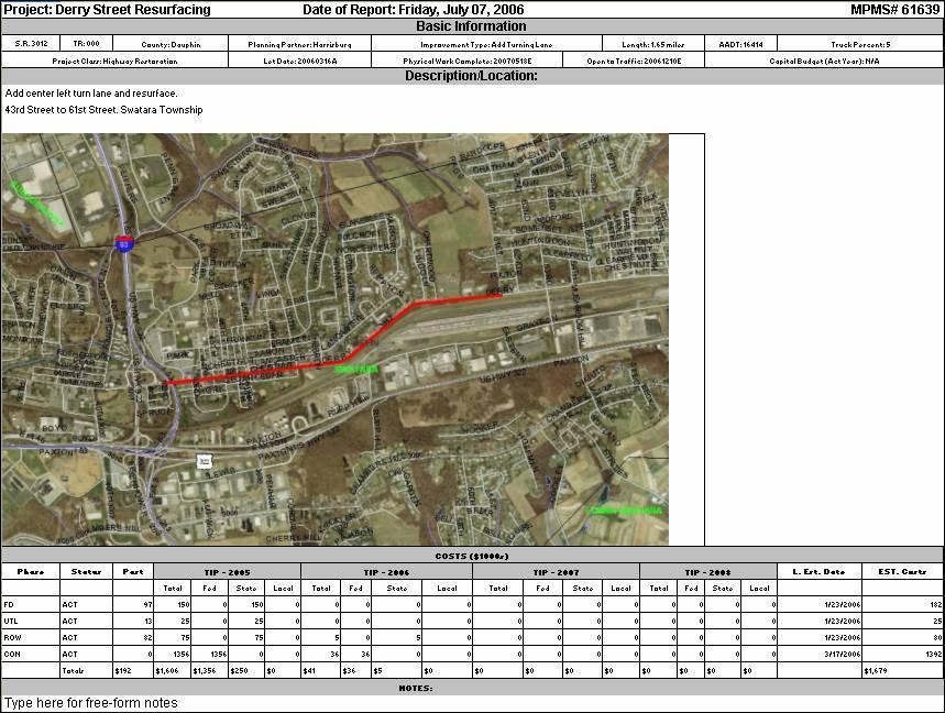
12 MPMS Maps Key Functions 3. Project Status Reports What is a Project Status Report? A map and data summary for a specific MPMS Project an Executive Summary Formatted to fit on one letter sized piece of paper Report data includes: Location, traffic, and improvement information Key milestone dates Let Open to Traffic Physical Work Complete Cost information Programmed Estimated (Intranet only)
13


14 MPMS Maps Key Functions 4. Aerial Photography Basemaps Aerial Photography Available to Intranet users via PA Map Currently not available to Internet users Varies in year and image resolution
15 MPMS Maps Key Functions 5. Various Search Capabilities Highlights of the Region Tab Various search parameters A region must always be selected Search by Program, TIP Status, and/or Project Class Region Program Project Status Project Class


16 Searching for Mapped Projects Using the Search Panel Three Search Tabs Are Available: ID Tab 1. ID Tab 2. Region Tab 3. Segments Tab Region Tab Segments Tab


17 Searching for Mapped Projects Map Template All Tabs No District provides a statewide basemap PA House PA House district boundaries PA Senate PA Senate district boundaries US Congress US Congressional district boundaries PA Senate and Aerial Photo Aerial Photo (Intranet only) Aerial Photo Basemaps This option may be combined with another map template State and Local Bridges You can map state and local bridges in any regions.


18 Searching for Mapped Projects ID Tab The ID tab allows users to search by: MPMS Project ID PA House District Number PA Senate District Number US Congress District


19 Searching for Mapped Projects Region Tab The Region tab allows users to search by: Region TIP Program Project Status Project Class


20 Searching for Mapped Projects Region Tab Map by Program All All mappable projects on previous, current and draft TYPs and all General Maintenance projects in MPMS TIP All mappable projects on the first four years of the Current TYP Underway/Complete All mappable projects that have a Notice to Proceed or are Open to Traffic Candidates All mappable projects that are listed has candidates in MPMS Interstate TIP All mappable projects that are listed has Interstate TIP in MPMS.


21 Searching for Mapped Projects Region Tab Map by Status Construction Started All mappable projects that have a Notice to Proceed date and do not have an actual Physical Work Complete Date or Open to Traffic Date in MPMS. Completed All mappable projects that have an actual Physical Work Completion date in MPMS Open to Traffic All mappable projects that have an actual Open to Traffic date in MPMS Let Date Filter All mappable projects that have a let of either actual or estimate in a user defined date range in MPMS
22 Searching for Mapped Projects Region Tab Map by Project Class Searching by Project Class All MPMS Project Classes are selectable The user may select one, multiple, or all project classes Use the Control and Shift keys to select multiple project classes


23 Select a: Searching for Mapped Projects Segments Tab County State Route SR Segment The mapped segment is blue

 The VideoLog Application opens VidLog Opens")
24 Searching for Mapped Projects Segments Tab VideoLog The Segments Tab features a link to the Videolog Application Click the mapped segment (highlighted in blue) The VideoLog Application opens VidLog Opens Click here
25 Other features Plot your own Map up to 22X34 Export to map elements to shape files Report Queries exported to excel Color Code by Project Class Output a Standalone Map to take anywhere


26 Training and Help User guide Intranet Internet (in development) Camtasia Tutorial First Time User Documentation Online Help Desk MPMS Help Desk Opens Click here
27 Future Enhancements Map local projects Add Department Environmental Protection (DEP) regions to map template Add International Roughness Index (IRI) map to map template
28 Links INTERNET Available to the General Public INTRANET Available to PENNDOT Staff
29 Conclusion Introduction to MPMS Maps Key Functions of MPMS Maps Searching for Mapped Projects Help and User Guide Future Enhancements Links
30 Contact Information John Parker PENNDOT Phone
Project Tracker. User s Guide. Texas Department of Transportation TPP
 Project Tracker User s Guide Texas Department of Transportation TPP Version 2.0 April 15, 2018 Table of Contents Table of Contents... 1 Purpose... 2 Getting Started Quick Steps... 2 Navigation... 4 Keyword
State Research Needs in GIS
 State Research Needs in GIS Robert Fuhler GIS Section Environmental Division Arkansas State Highway and Transportation Department GIS T, Nashville Tennessee March 27, 2007 Research Needs Most Common Research
NBMG Mining District Files
 NBMG Mining District Files A guide to using the Mining Districts interactive map to search the database files OVERVIEW: Creation of map services and interactive maps are an important component of the Nevada
Tutorial for Lane County Mapping Applications
 Tutorial for Lane County Mapping Applications Contents Overview... 2 Tools... 2 Navigation Tools... 3 Display Tools... 5 Information Tools... 6 Sharing Tools... 7 Common Tasks... 9 Identify or Show Data
Peoria County Front Desk Map Application
 Peoria County Front Desk Map Application Quick Guide, 2017 At a First Glance This guide will tell users all they need to know about the Peoria County Front Desk application which can be found on the Peoria
Welcome, please click on the hyperlink below to be directed to Sacramento County Online Maps. Survey's GIS Online Map
 Welcome, please click on the hyperlink below to be directed to Sacramento County Online Maps. Survey's GIS Online Map If the link does not work copy and paste the following address into your browser address
SAGIS Property Map Viewer Instruction Manual Instructions for using the SAGIS Property Map Viewer. Published December 21, 2018.
 SAGIS Property Map Viewer Instruction Manual www.sagis.org/map Instructions for using the SAGIS Property Map Viewer. Published December 21, 2018. 1 Instructional Videos Click on a link to watch a video
Map Functions August 3, 2015 Triangle Homes Group
 Map Functions August 3, 2015 Triangle Homes Group Preston Neighborhoods and Property Map The Map is an interactive web based using ArcGIS Online by ESRI ESRI is the world s largest Geographic Information
Iowa Department of Transportation Statewide Coordinated GIS
 1998 TRANSPORTATION CONFERENCE PROCEEDINGS 187 Iowa Department of Transportation Statewide Coordinated GIS WILLIAM G. SCHUMAN, TIM STRAUSS, DAN GIESEMAN, AND REGINALD R. SOULEYRETTE This paper details
How to design and print cards using a database connection with. emedia CS Software
 How to design and print cards using a database connection with emedia CS Software For this exercise, we will use a Database that has been created in EXCEL. The example below shows the database fields populated
This guide will tell you all you need to know about the new Front Desk application which can be found on the main Peoria County GIS website.
 New Front Desk Quick Guide, 2014 At a First Glance This guide will tell you all you need to know about the new Front Desk application which can be found on the main Peoria County GIS website. When you
Create and Submit a Project for Review
 Create and Submit a Project for Review The review process occurs in two stages. In the first stage, the user creates a project and submits it for an initial review. In the second stage, the user reviews
Place Survey Mosaic Indicator
 Place Survey Mosaic Indicator PlanWeb is a simple mapping tool available to all staff and partners. This Geographical Information System (GIS) is available free through the Lincolnshire http://shared.research-lincs.org.uk
The University of Arizona
 1 The University of Arizona Campus 360 Web Map Help Guide v 1.3.1 Revised Aprils 2018 https://maps.arizona.edu/campus360/ 2 CONTENTS INTRODUCTION MAP CONTROLS Zoom in, zoom out...p. 4 Map Control toolbar
Overview of CCSD Secure Cropper Map
 Overview of CCSD Secure Cropper Map Map Components: 1. Menu Options Use these menus to interact with the map. View School Zones: Use this menu to choose which school zone map to view. Select Students:
Service Minder Plus Features/Helpful Hints
 Service Minder Plus Features/Helpful Hints NOTE: These items will be addressed during the training sessions. This document is meant to be an overview resource for after completion of training. General
Road Condition Reporting System (RCRS)
") Road Condition Reporting System () Version 008.000.xxx Technical Design Document May 10, 2011 Document Revision Information Version Num. Edit Date Edited By Comments 1.0 05/10/2011 Bob Wagner Initial Draft
Road Condition Reporting System () Version 008.000.xxx Technical Design Document May 10, 2011 Document Revision Information Version Num. Edit Date Edited By Comments 1.0 05/10/2011 Bob Wagner Initial Draft
Cuyahoga County Addressing Notification System Cuyahoga County Department of Information Technology
 Page(s) 1 of 10 Administrative Standard Operating Procedure Cuyahoga County Addressing Notification System Cuyahoga County Department of Information Technology Document Revision History Date of Revision
Census Small Area Population Statistics (SAPS) A Guide to using the SAPMAP web application
 A Guide to using the SAPMAP web application") Census Small Area Population Statistics (SAPS) A Guide to using the SAPMAP web application 1 When you open the application you will see this page. This screen gives a brief description of the application.
Census Small Area Population Statistics (SAPS) A Guide to using the SAPMAP web application 1 When you open the application you will see this page. This screen gives a brief description of the application.
GIS Virtual Workshop: Creating a Final Map
 To create a map that will be pleasing to an end user, in a static format requires that certain items be added to the map such as a direction arrow, scale, title and legend. Including this information on
P2 MANUAL FOR WEB-BASED TXDOT RIGID PAVEMENT DATABASE. Authors: Sureel Saraf Moon Won
 0-5445-P2 MANUAL FOR WEB-BASED TXDOT RIGID PAVEMENT DATABASE Authors: Sureel Saraf Moon Won TxDOT Project 0-5445: Project Level Performance Database for Rigid Pavements in Texas SEPTEMBER 2007, REV. JULY
VTrans Route Logs. Python-driven Map Automation with Straight Line Diagrams. Kerry Alley and Michael Trunzo GIS-T 2014
 VTrans Route Logs Python-driven Map Automation with Straight Line Diagrams Kerry Alley and Michael Trunzo GIS-T 2014 Today s Presentation Straight Line Diagrams Route Log Anatomy VTrans Route Log History
Texas Connector Training Manual. For TDCJ Users [2016]
![Texas Connector Training Manual. For TDCJ Users [2016]](/thumbs/79/80112153.jpg "Texas Connector Training Manual. For TDCJ Users [2016]") Texas Connector Training Manual For TDCJ Users [2016] CONTENTS OneStar Foundation and Texas Connector Overview... 3 The Data... 3 How To Log In... 4 TDCJ Quick Report Generator... 4 The Map... 8 Support
Texas Connector Training Manual For TDCJ Users [2016] CONTENTS OneStar Foundation and Texas Connector Overview... 3 The Data... 3 How To Log In... 4 TDCJ Quick Report Generator... 4 The Map... 8 Support
Table of Contents 6.1 CORRESPONDENCE
 Table of Contents Section Page 6.1 CORRESPONDENCE... 6.1-1 6.1.1 In-House Memoranda... 6.1-1 6.1.1.1 General... 6.1-1 6.1.1.2 Format... 6.1-1 6.1.1.3 Signatures... 6.1-1 6.1.1.4 Distribution... 6.1-2 6.1.2
Projects. Major MPO. Fund. Reports
 The VDOT Six-Year Improvement Program web site provides an overview of all of the development and construction projects included in the agency s long-term plans. The webbased application gives you the
Newaygo County Web Map
 Newaygo County Web Map Address/Parcel/Parcel Owner Search Map Overview Zoom Back to default extent Use your current location if allowable Widget Panel At the top of the map is a search function used for
Interactive Maps Purpose: Login to the System: Interactive Maps ONTINUE AGREE
 Interactive Maps Purpose: The purpose of this application is to provide the facility to the citizen to navigate to a Property through an On-line Free Web Application in real time. The application uses
RPMA - Roadway Project Mapping Application
 RPMA - Roadway Project Mapping Application RPMA Training Documentation Version: 1/9/2018 Title of Report 1 Table of Contents Table of Contents...2 Background Info on Roadway Project Mapping Application...3
Why U.S. Political Stats? Search and Browse. Using the Quick Search. Using the Browse Options
 Overview Why U.S. Political Stats? Visualize political data in multiple formats. U.S. Political Stats is a data visualization and research tool. It contains data on the three branches of U.S. government
Update: October 21, 2013
 Update: October 21, 2013 CADD Engineering Standards Manual The following section was revised: Section 502.1 General Page 92 The following verbiage was added: Per section 1307.1 of the L&D Manual s Volume
INSTRUCTIONS FOR THE ON-LINE APPLICATION
 INSTRUCTIONS FOR THE ON-LINE APPLICATION Effective January 1, 2018, the 901 Municipal Planning Grant Application must be submitted through the Department of Community and Economic Development s (DCED)
LeeSpInS 2.0 Help Guide
 LeeSpInS 2.0 Help Guide http://leegis.leegov.com/leespins/ E-mail us at gis@leegov.com with any questions or issues using this site Navigation Tools Pan arrows scroll the map in the arrow direction or
City of La Crosse Online Mapping Website Help Document
 City of La Crosse Online Mapping Website Help Document This document was created to assist in using the new City of La Crosse online mapping sites. When the website is first opened, a map showing the City
REDI 5.0 User Manual
 REDI 5.0 User Manual OBJECTIVE: REDI (Regional Economic Development Information System) provides a quick, convenient and easy way of accessing the City of San Diego Business Incentive Zones (BIZ) information.
Membership Portal Manual
 Membership Portal Manual Table of Contents Login... 4 Contact Tab... 6 Contact Information Dropdown...6 Features on the Contact Information Dropdown... 6 Account Information Dropdown...6 Features on the
Pipeline Online Permitting System (POPS) External User Guide
 External User Guide") Pipeline Online Permitting System (POPS) External User Guide Railroad Commission of Texas Information Technology Services Division October 2018 Table of Contents Table of Contents... i Pipeline Online
Pipeline Online Permitting System (POPS) External User Guide Railroad Commission of Texas Information Technology Services Division October 2018 Table of Contents Table of Contents... i Pipeline Online
How to get to information without drilling down through a gazillion layers or being a GIS power user
 One Stop Shopping How to get to information without drilling down through a gazillion layers or being a GIS power user Our Mission Managing fish and wildlife resources for their long-term well-being and
We will start at 2 minutes after the hour
 Introduction to the UDS Mapper Webinar 1 We will start at 2 minutes after the hour Slides from today s webinar can be found on the UDS Mapper website in the Tutorials & Resources tab in the Tutorials section
Number Screen Element. App Lake County Logo: Displays the logo for Lake County, Colorado.
 The Main Screen When you open any of the Lake County maps, a screen similar to the one below will appear. The buttons at the bottom will vary between maps, the order will remain similar. Number Screen
Remote Sensing in an
 Chapter 2: Adding Data to a Map Document Remote Sensing in an ArcMap Environment Remote Sensing Analysis in an ArcMap Environment Tammy E. Parece Image source: landsat.usgs.gov Tammy Parece James Campbell
Instructions: DRDP Online Child Upload
 Instructions: DRDP Online Child Upload Version 1.00 10/29/2018 Table of Contents Introduction... 2 Upload Roles... 2 Upload Template... 2 Entering Data into the Template... 3 Uploading to DRDP Online...
Texas Connector Training Manual [2016]
![Texas Connector Training Manual [2016]](/thumbs/87/96002696.jpg "Texas Connector Training Manual [2016]") Texas Connector Training Manual [2016] CONTENTS OneStar Foundation and Texas Connector Overview... 2 The Data... 2 How To Create An Account... 3 How To Log In... 3 How To Create An Account Visual Guide
Texas Connector Training Manual [2016] CONTENTS OneStar Foundation and Texas Connector Overview... 2 The Data... 2 How To Create An Account... 3 How To Log In... 3 How To Create An Account Visual Guide
Training Guide Employee Self Service Candidate Gateway Apply
 Employee Self Service Candidate Gateway Page i ESS - Candidate Gateway - Candidate Gateway enables internal applicants (employees) to: Submit job applications and resumes without applying to a specific
Iowa s Statewide Road Centerline Cooperative Program. Bill Schuman, GIS Coordinator Iowa Department of Transportation
 Iowa s Statewide Road Centerline Cooperative Program Bill Schuman, GIS Coordinator Iowa Department of Transportation Session Outline Current goals of Statewide Road Centerline Project Project challenges
Texas Legislative Council
 Texas Legislative Council Clare Dyer, Manager, Mapping & Redistricting Ed Clow, GISP, Programmer Analyst, Applications Marshall Kunze, Programmer, Applications Texas Redistricting 2011 Time frame for Texas
KDHE Watershed Management Web Map Editor Standard Operating Procedures (SOP) A. How to get Watershed Assignment? a. View Watershed Status
 A. How to get Watershed Assignment? a. View Watershed Status") KDHE Watershed Management Web Map Editor Standard Operating Procedures (SOP) A. How to get Watershed Assignment? a. View Watershed Status B. How to prepare web map for editing. a. Change visible Layers
KDHE Watershed Management Web Map Editor Standard Operating Procedures (SOP) A. How to get Watershed Assignment? a. View Watershed Status B. How to prepare web map for editing. a. Change visible Layers
UTILITY RELOCATION ELECTRONIC DOCUMENT MANAGEMENT SYSTEM (UREDMS)
") UTILITY RELOCATION ELECTRONIC DOCUMENT MANAGEMENT SYSTEM (UREDMS) TRAINING MANUAL EXTERNAL USERS prepared for Commonwealth of Pennsylvania Department of Transportation Bureau of Project Delivery VERSION
UTILITY RELOCATION ELECTRONIC DOCUMENT MANAGEMENT SYSTEM (UREDMS) TRAINING MANUAL EXTERNAL USERS prepared for Commonwealth of Pennsylvania Department of Transportation Bureau of Project Delivery VERSION
National Levee Database (NLD) User Manual: Public User. US Army Corps of Engineers (USACE)
 User Manual: Public User. US Army Corps of Engineers (USACE)") National Levee Database (NLD) User Manual: Public User Prepared by US Army Corps of Engineers (USACE) NLD Public User Manual Document Change Record Army Corps of Engineers Version Number Date Description.0
National Levee Database (NLD) User Manual: Public User Prepared by US Army Corps of Engineers (USACE) NLD Public User Manual Document Change Record Army Corps of Engineers Version Number Date Description.0
Florida s Integrated Report Exchange System (FIRES) Public Crash Portal Resource and Tutorial Guide
 Public Crash Portal Resource and Tutorial Guide") Florida s Integrated Report Exchange System (FIRES) Public Crash Portal Resource and Tutorial Guide Table of Contents Overview and Types of Crashes Included Page 3 Quick Statistics.Pages 4-5 Advanced Search..Pages
Florida s Integrated Report Exchange System (FIRES) Public Crash Portal Resource and Tutorial Guide Table of Contents Overview and Types of Crashes Included Page 3 Quick Statistics.Pages 4-5 Advanced Search..Pages
_Tutorials. Arcmap. Linking additional files outside from Geodata
 _Tutorials Arcmap Linking additional files outside from Geodata 2017 Sourcing the Data (Option 1): Extracting Data from Auckland Council GIS P1 First you want to get onto the Auckland Council GIS website
GIS Basics for Urban Studies
 GIS Basics for Urban Studies Date: March 21, 2018 Contacts: Mehdi Aminipouri, Graduate Peer GIS Faciliator, SFU Library (maminipo@sfu.ca) Keshav Mukunda, GIS & Map Librarian Librarian for Geography (kmukunda@sfu.ca)
North Central Texas Council of Governments
 Making Data Useful North Central Texas Council of Governments Research and InformationServices March 29, 2012 NCTCOG Voluntary association of, by, and for local governments Assist local governments Planning
FAQ & Troubleshooting
 FAQ & Troubleshooting What is the most common issue users have when using the site? Pop-Up Blocker!!! Any link external to the viewer requires a new window to be opened in the browser. See My map or report
TRIP Instructions for DAY TRIP
 PROCESS/PROCEDURE TRIP is the University of Kentucky s system for reimbursements to employees for business travel related expenses. Use the Day TRIP for Monthly Travel that does not include lodging. For
Quick Start Guide. Intermap Technologies 8310 South Valley Highway, Suite 400 Englewood, CO USA
 ADPRO Quick Start Guide Intermap Technologies 8310 South Valley Highway, Suite 400 Englewood, CO 80112 USA No part of this document may be reproduced, stored in a retrieval system, or transmitted in any
Descriptive Statistics. Project 3 CIVL 3103
 Project 3 CIVL 3103 Descriptive Statistics Introduction In our course, we have discussed interpolation for a single set of point data. However, many datasets that are used by engineers are spatial in nature,
PNDI Environmental Review Process
 Open the PA Natural Heritage Program website at http://www.naturalheritage.state.pa.us To access the PNDI Environmental Review tool, click the Conservation Explorer - PNDI Environmental Review link on
Tutorial for County View Web:
 Tutorial for County View Web: A Guide for Users Highlights Page 2: Introduction Page 3: Getting Started with County View Page 4: View Property Information Page 6: View Selected Planning Application Page
Service Minder Plus Features/Helpful Hints
 Service Minder Plus Features/Helpful Hints This manual covers helpful hints and use of features. Note: These items will be addressed during the training sessions. This document is meant to be used as an
Version 2 Midas Production Site Field Instructions
 Version 2 Midas Production Site Field Instructions September 2018 FOREST INVENTORY AND ANALYSIS NORTHERN RESEARCH STATION USDA FOREST SERVICE 1 Table of Contents Introduction... 3 Section 1: Initial Logon
Greater Bridgeport Regional Council Municipal GIS Viewer Training April 2015
 Greater Bridgeport Regional Council Municipal GIS Viewer Training April 2015 GBRC GIS Web Training Table of Contents Introduction........................................................... 3 Viewer Components.......................................................
Len Preston Chief, Labor Market Information New Jersey Department of Labor & Workforce Development
 Len Preston Chief, Labor Market Information New Jersey Department of Labor & Workforce Development Cooperative project of the State of New Jersey and the U.S. Bureau of the Census serving data users in
Regional Operations Traffic Signals Task Force Meeting #1 February 13, 2007
 South Central Pennsylvania Regional Operations Traffic Signals Task Force Meeting #1 PennDOT Executive Goal # 6 Effectively and efficiently operate the transportation system Agenda Introductions Purpose
Working with International Census Data in GIS
 Working with International Census Data in GIS Updated February 23, 2015 Table of Contents SETTING UP... 1 DATA SOURCES... 1 TABULAR CENSUS DATA... 2 2001 Tabular Census Data... 5 GEOGRAPHIC DATA... 5 JOINING
Understanding ArcGIS Online - why organizations should embrace the cloud now
 Understanding ArcGIS Online - why organizations should embrace the cloud now Presented to: GeoAlberta - workshop Presented by: David Parry September 25, 2013 Today s Agenda Introduction - Why the Cloud?
WisTMP Frequently Asked Questions
 WisTMP System FAQs 1. How do I get access to the WisTMP system? 2. How can I be added to the system? 3. Who has system administrative access and what features are they permitted access? 4. Does the system
Highway Performance Monitoring System
 Highway Performance Monitoring System Version 1.0 June 2011 Quick Start Guide for Version 8.0 Federal Highway Administration Table of Contents Chapter 1 Introduction... 1 Chapter 2 HPMS Workflow... 2 Chapter
Step One: Consider choosing Firefox as your browser when using Flexmls. Very conducive to computer operating system needs.
 MLS 101 Introduction to features Sign in and modify profile information Find and view MLSSAZ documents Create and edit your contacts Become familiarized with the Map Search Save searches and listing collections
How to Use Reporting Tools. A supplemental support document for TBB Administrators QUICK REFERENCE. Phone: TBB-HELP
 THE BENEFIT BANK How to Use Reporting Tools A supplemental support document for TBB Administrators QUICK REFERENCE Login Information TBB Help Desk Website: www.thebenefitbank.com Phone: 1-855-TBB-HELP
Juniata County, Pennsylvania
 GIS Parcel Viewer Web Mapping Application Functional Documentation June 21, 2017 Juniata County, Pennsylvania Presented by www.worldviewsolutions.com (804) 767-1870 (phone) (804) 545-0792 (fax) 115 South
Customizing Survey123 Customization & Submission URL. Kelly Fisher, Project/GIS Manager GeoDecisions
 Customizing Survey123 Customization & Submission URL Kelly Fisher, Project/GIS Manager GeoDecisions Topics/Discussions Desktop Web Device PennDOT STAMPP Review Current STAMPP Application Why Change Current
US Geo-Explorer User s Guide. Web:
 US Geo-Explorer User s Guide Web: http://usgeoexplorer.org Updated on October 26, 2016 TABLE OF CONTENTS Introduction... 3 1. System Interface... 5 2. Administrative Unit... 7 2.1 Region Selection... 7
NORTH COUNTY CORRIDOR EXPRESSWAY TRANSPORTATION AUTHORITY. SUBJECT: Jacobs Engineering Contract; Task Order #2 and Task Order #3 Acceptance
 NORTH COUNTY CORRIDOR EXPRESSWAY TRANSPORTATION AUTHORITY ITEM: 6B SUBJECT: Jacobs Engineering Contract; Task Order #2 and Task Order #3 Acceptance Jacobs Engineering has completed Task 1 with amendment
Quick Guide FAST HR. For more resources, including a guide on FAST HR codes, visit # Instructions Screenshot
 Tips & tricks This quick guide describes basic navigation within the FAST HR reporting tool, including how to use filter options, format columns and export reports. For more resources, including a guide
Use of GIS/GPS for supporting field enumeration
 Regional Workshop on the Use of Technology in Population and Housing Censuses in Arab countries, Use of GIS/GPS for supporting field enumeration Palestine January 2018 Old censuses In census 1997 and 2007,
South Central ROP Projects
 Pennsylvania Department of Transportation ROP Overview and Summary South Central ROP Projects November 2007 77 INCIDENT MANAGEMENT (IM) Draft Version 1 July 2007-40 - IM 1: SOUTH CENTRAL PA ITS DEPLOYMENT
NJUNS Users Guide.
 NJUNS Users Guide www.njuns.com The National Joint Utilities Notification system, NJUNS, is a national organization of member utilities formed for the purpose of improving the coordination of joint ventures.
DISTRICT 6-0 REGIONAL OPERATIONS PLAN PENNSYLVANIA DEPARTMENT OF TRANSPORTATION ENGINEERING DISTRICT 6-0
 MINUTES OF MEETING (FINAL) PROJECT: PURPOSE OF MEETING: LOCATION: PENNDOT Agreement E00229 Open-end Agreement for ITS, Traffic and Highway Safety Engineering Services Work Order 016 - District 6-0 Regional
Greetings! Washington Location Finder Project Exchange Network Conference April 2011
 Greetings! Washington Location Finder Project Exchange Network Conference April 2011 Partners: Washington Department of Ecology Washington Department of Health Environmental Information Exchange Network
Full Search Map Tab Overview
 FlexMLS Map Server Full Search Map Tab Overview The Full Search Map tab is a need to know module. It is accessible when you use Full Search under Search in the Main Menu tree of FlexMLS. This map can
Mn/DOT MnCMAT Crash Analysis Application Help
 Mn/DOT MnCMAT Crash Analysis Application Contents Login... 5 User Login Dialog... 5 Login... 5 Request Access Dialog... 5 Forgotten Password Dialog... 6 Create/Open Project... 7 Create/Open Project Dialog...
We will start at 2 minutes after the hour
 Using the UDS Mapper to Create Service Area Maps Webinar 1 We will start at 2 minutes after the hour Slides from today s webinar can be found on the UDS Mapper website in the Tutorials & Resources tab
THE OFFICIAL VANUAL. The official guide to navigating voter and volunteer data using VAN every organizer s favorite campaign technology.
 THE OFFICIAL VANUAL The official guide to navigating voter and volunteer data using VAN every organizer s favorite campaign technology. WWW.NGPVAN.COM TABLE OF CONTENTS Welcome Logging In/Log out Navigating
VUEWorks Report Generation Training Packet
 VUEWorks Report Generation Training Packet Thursday, June 21, 2018 Copyright 2017 VUEWorks, LLC. All rights reserved. Page 1 of 53 Table of Contents VUEWorks Reporting Course Description... 3 Generating
Invitation to Negotiate (ITN) epermitbuilder System DEP Solicitation Number: APPENDIX C - PERMIT TEMPLATES IDENTITY GUIDELINES DRAFT
 epermitbuilder System DEP Solicitation Number: APPENDIX C - PERMIT TEMPLATES IDENTITY GUIDELINES DRAFT") Invitation to Negotiate epermitbuilder System DEP ITN No.: 2018019 Invitation to Negotiate (ITN) epermitbuilder System DEP Solicitation Number: 2018019 APPENDIX C - PERMIT TEMPLATES IDENTITY GUIDELINES
Invitation to Negotiate epermitbuilder System DEP ITN No.: 2018019 Invitation to Negotiate (ITN) epermitbuilder System DEP Solicitation Number: 2018019 APPENDIX C - PERMIT TEMPLATES IDENTITY GUIDELINES
2006 GIS-T T Symposium Columbus Ohio
 2006 GIS-T T Symposium Columbus Ohio Web-TELUS Improved Public Participation and Information Transparency Mike Lucas & Tom Harner Miami Valley Regional Planning Commission 1 MVRPC Background Miami Valley
We will start at 2 minutes after the hour
 Introduction to the UDS Mapper Webinar 1 We will start at 2 minutes after the hour Slides from today s webinar can be found on the UDS Mapper website in the Tutorials & Resources tab in the Tutorials section
How to calculate population and jobs within ½ mile radius of site
 How to calculate population and jobs within ½ mile radius of site Caltrans Project P359, Trip Generation Rates for Transportation Impact Analyses of Smart Growth Land Use Projects SECTION PAGE Population
Digitising a map in arcgis desktop 10.3
 Digitising a map in arcgis desktop 10.3 1 CONTENTS 2 Evaluating your map... 2 3 Setting up the base map... 3 4 Georeferencing your map/maps... 3 4.1 Georeferencing tips.... 4 5 Digitising your maps...
A Guide to Using the Planning Office s Interactive Maps
 A Guide to Using the Planning Office s Interactive Maps This guide is intended to assist the user in using the maps provided on the County Planning Office website that are branded as Interactive Maps.
WAIPA DISTRICT COUNCIL. Maps Online 9. Updated January This document contains an overview of IntraMaps/Maps Online version 9.
 WAIPA DISTRICT COUNCIL Maps Online 9 Updated January 2018 This document contains an overview of IntraMaps/Maps Online version 9.0 Contents Starting Maps Online... 3 Menu Bar... 4 Tools... 5 View Tab...
LOCAL STREETS AND THE ARNOLD INITIATIVE
 LOCAL STREETS AND THE ARNOLD INITIATIVE Jenn Sylvester, Mapping Branch Team Lead Transportation Planning & Programming Division (TPP) GIS-T Symposium Des Moines, IA Key Terms 1 2 3 ARNOLD FC Streets Local
Highway Advertising Sign Mobile Data Capture and Permit Management GIS OAPRT Mobile and OAPRT Web-based Applications
 Highway Advertising Sign Mobile Data Capture and Permit Management GIS OAPRT Mobile and OAPRT Web-based Applications Client Minnesota Department of Transportation (Mn/DOT) St. Paul, Minnesota Project In
TMS Quick Help Guide
 TMS Quick Help Guide www.ms2soft.com Table of Contents 1.0 Introduction 1 2.0 New Locations 3 2.1 New TCDS Locations 4 2.2 New TSMS Locations 8 3.0 Administration Page 11 3.1 TCDS Admin Page 11 3.2 TSMS
Coordinate Systems/Units
 GIS and Mapping Procedures in fgis Beginning a fgis Project Adding Basemap Data Adding GPS Data Editing Layer Properties Checking Feature Attributes Adding Acres to Area Features Adding Acres Labels to
1 Getting Started. By the end of this section, you will be able to: Use the Student Guide. Log on to SiteManager View the SiteManager Panel
 1 Getting Started By the end of this section, you will be able to: Use the Student Guide Log on to SiteManager View the SiteManager Panel Control the Display of Multiple SiteManager Components Close Versus
How to Create Metadata in ArcGIS 10.0
 How to Create Metadata in ArcGIS 10.0 March 2012 Table of Contents Introduction... 1 Getting Started... 2 Software Requirements... 2 Configure ArcGIS Desktop to View FGDC Metadata... 2 Other Thoughts...
DEPARTMENT OF EDUCATION
 DEPARTMENT OF EDUCATION RESEARCH AND DEVELOPMENT Contents Revision History... 3 Revision History Chart... 3 Overview... 4 Application Permissions... 4 1. How do I get started?... 5 System Selection...
Manitowoc County, WI Advanced Access GIS Viewer User Documentation
 Manitowoc County, WI Advanced Access GIS Viewer User Documentation Introduction Extensive time was put into developing this website both from a display, and from a printing and scaling perspective. This
Map Direct Lite. Quick Start Guide: Map Layers 5/14/2018
 Map Direct Lite Quick Start Guide: Map Layers 5/14/2018 Contents Quick Start Guide: Map Layers... 1 Map Layers in Map Direct Lite.... 3 What is a Basemap Layer?... 4 Change the Basemap Using the Basemap