Highway Advertising Sign Mobile Data Capture and Permit Management GIS OAPRT Mobile and OAPRT Web-based Applications
|
|
|
- Toby Moody
- 5 years ago
- Views:
Transcription
1 Highway Advertising Sign Mobile Data Capture and Permit Management GIS OAPRT Mobile and OAPRT Web-based Applications Client Minnesota Department of Transportation (Mn/DOT) St. Paul, Minnesota Project In the past, the tracking, administration, and permitting of outdoor advertising signs adjacent to state and federal highways in Minnesota had been done using manual processes. Mn/DOT determined a need to develop and implement an application that would assist in the capture of highway advertising sign locations and the management of those signs along with their associated permits. The system would streamline these tasks, giving Mn/DOT staff the capability to take advantage of GPS connectivity and mobile mapping technology and providing a cost-effective, efficient alternative to the previous manual management effort. The application would utilize GPS for locating and navigating to signs in the field, and would provide users with the capability to edit attributes of existing records, update the location of existing signs, and capture the locations of unassigned signs while in the field. Great Arc's Solution Great Arc worked with Mn/DOT to design, develop, and implement an application to view, navigate, update, and maintain outdoor advertising permit data using Trimble GeoXT mobile devices. The application synchronizes with the Outdoor Advertising Permit Reporting and Tracking (OAPRT) system on the Mn/DOT network, allowing each user to download OAPRT data as well as roadway and county and municipal boundary data for the state district(s) to which they are assigned. The OAPRT Mobile application provides tools for finding OAPRT records using any of the feature attributes as search criteria (Permit Number, Customer, City, District, and many others) or by making a spatial selection on the interactive map. Users can then update selected features, editing their attributes and/or capturing new location information using GPS or an attached laser range finder device. Additionally, users may add new records while in the field by capturing location information and entering as much attribute data as is available. The application provides users with an interactive map display, including tools for zooming, panning, feature identification, feature selection, and measurement between map features. Users may toggle features for auto-centering the map which re-centers the map using the user s GPS position, for example when navigating to a sign location as well as an alert function which automatically sounds an alert when the user approaches an OAPRT sign. When users have made updates to the data on the mobile device, whenever they have network connectivity they may then upload their changes back to the Mn/DOT server using the Data Sync function, which copies the data back up to the server and allows the user to pull down a fresh dataset and continue their field work.


2 For additional access to the outdoor advertising data, Great Arc developed a custom web-based mapping application for viewing OAPRT data. Mn/DOT staff can navigate and search state-wide OAPRT data using through a user-friendly web browser-based application. The web application provides tools for navigation, viewing, and attribute searching for permit and unassigned records. Authorized users may log in to assign permit records to unassigned signs. Key Software/Technology Used ArcGIS Server ESRI Flex API for ArcGIS Server Crystal Reports Web Services VB.Net Oracle OAPRT Mobile Main Menu OAPRT Mobile Pull Data from Server


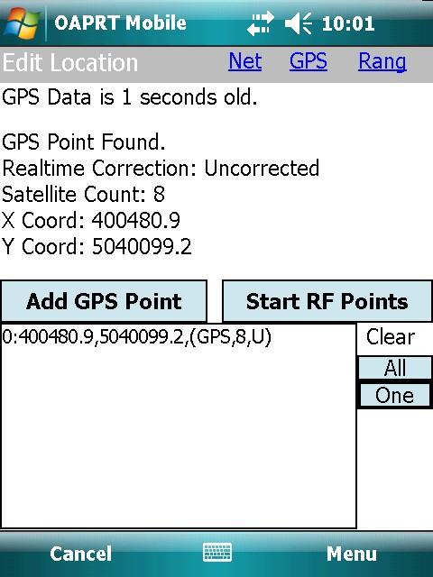
3 OAPRT Mobile Map Display OAPRT Mobile Find OAPRT Sign OAPRT Mobile Edit Permit Attributes OAPRT Mobile Edit Location

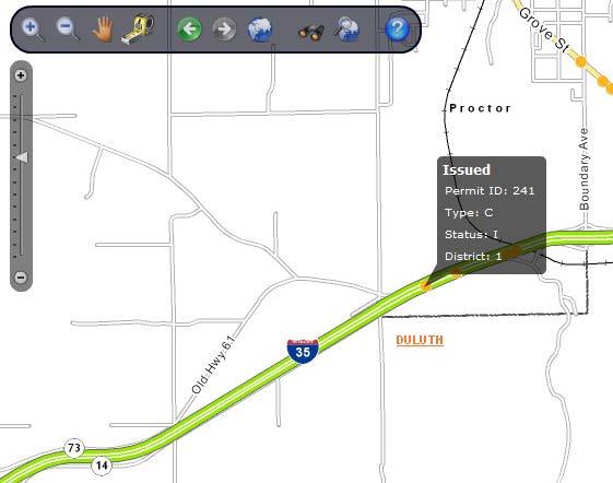
4 OAPRT Web Application OAPRT Web Application Permit Feature


5 OAPRT Web Application Selected Features and Data Grid OAPRT Web Application Assign to Permit Dialog
COMMISSION OF TEXAS MAY
 GIS Viewer RAILROAD COMMISSION OF TEXAS MAY 2017 Table of Contents GIS Viewer Basics... 1 Basics... 1 Screen Overview... 2 Tools... 5 Visibility... 5 Measure Tool... 7 Identify Tool... 10 Coordinates Tool...
Map Direct Lite. Quick Start Guide: Map Layers 5/14/2018
 Map Direct Lite Quick Start Guide: Map Layers 5/14/2018 Contents Quick Start Guide: Map Layers... 1 Map Layers in Map Direct Lite.... 3 What is a Basemap Layer?... 4 Change the Basemap Using the Basemap
Mn/DOT MnCMAT Crash Analysis Application Help
 Mn/DOT MnCMAT Crash Analysis Application Contents Login... 5 User Login Dialog... 5 Login... 5 Request Access Dialog... 5 Forgotten Password Dialog... 6 Create/Open Project... 7 Create/Open Project Dialog...
MS2. Modern Traffic Analytics ms2soft.com
 MS2 Modern Traffic Analytics ms2soft.com Updated: October 31, 2014 The Traffic Count Database System (TCDS) module is a powerful tool for the traffic engineer or planner to organize an agency's traffic
MAP ASPEN Training Manual. Navigate back to City of Aspen Home, GIS Home, Map Aspen Home or the Data Catalog from any page in the site.
 Home Page Features: Top Navigation Bar MAP ASPEN Training Manual Navigate back to City of Aspen Home, GIS Home, Map Aspen Home or the Data Catalog from any page in the site. Search Bar Search for all content
ImageNow Interact for Esri ArcGIS Server for Silverlight Getting Started Guide
 ImageNow Interact for Esri ArcGIS Server for Silverlight Getting Started Guide Esri Silverlight Viewer Tools ImageNow Version: 6.6.x Written by: Product Documentation, R&D Date: January 2013 ImageNow and
Cuyahoga County Addressing Notification System Cuyahoga County Department of Information Technology
 Page(s) 1 of 10 Administrative Standard Operating Procedure Cuyahoga County Addressing Notification System Cuyahoga County Department of Information Technology Document Revision History Date of Revision
Lab Assignment 4 Basics of ArcGIS Server. Due Date: 01/19/2012
 Lab Assignment 4 Basics of ArcGIS Server Due Date: 01/19/2012 Overview This lab assignment is designed to help you develop a good understanding about the basics of ArcGIS Server and how it works. You will
Section 1: Introduction to Arc GIS 10
 Introduction to ArcGIS 10 Getting Started 1.1.1 Section 1: Introduction to Arc GIS 10 A main component of ArcGIS 10 software is ArcMap. It can be used to create and edit maps and analyze spatial data.
KEEPING DATA ACCURATE WITH THE DUSA APPLICATION
 KEEPING DATA ACCURATE WITH THE DUSA APPLICATION Jenn Sylvester, Mapping Branch Team Lead Adam Breznicky, Mapping Branch Web Master Transportation Planning & Programming Division (TPP) ESRI International
P2 MANUAL FOR WEB-BASED TXDOT RIGID PAVEMENT DATABASE. Authors: Sureel Saraf Moon Won
 0-5445-P2 MANUAL FOR WEB-BASED TXDOT RIGID PAVEMENT DATABASE Authors: Sureel Saraf Moon Won TxDOT Project 0-5445: Project Level Performance Database for Rigid Pavements in Texas SEPTEMBER 2007, REV. JULY
Map Functions August 3, 2015 Triangle Homes Group
 Map Functions August 3, 2015 Triangle Homes Group Preston Neighborhoods and Property Map The Map is an interactive web based using ArcGIS Online by ESRI ESRI is the world s largest Geographic Information
TRAINING GUIDE. Mobile for Administrators Part 3 - GIS
 TRAINING GUIDE Mobile for Administrators Part 3 - GIS Mobile for Administrators - GIS One of the critical components of mobile is GIS, and it can also be the most complex. The mobile GIS maps are designed
Collector for ArcGIS Preparing for and Working in a disconnected environment
 Collector for ArcGIS Preparing for and Working in a disconnected environment Peter Nasuti, Dan Moore, Nicholas Davis Topics Covered With demonstrations throughout each step 1) What is Collector? What can
Accessing OGC Services To access OGC WMS and WFS open the service in the directory that you want to consume, and click on either WMS or WFS.
 Using Web Services Web Services Overview This user guide contains instructions on how to consume a range of services through a range of both web based and desktop GIS applications. Web services are a live
Coordinate Transformation for Macau Data Using ArcGIS for Desktop
 Coordinate Transformation for Macau Data Using ArcGIS for Desktop Article ID : TT100062 Software : ArcGIS 10.2 for Desktop Platform : Windows 7, Windows 8, Windows Server 2003, Windows Server 2008/R2 Date
Juniata County, Pennsylvania
 GIS Parcel Viewer Web Mapping Application Functional Documentation June 21, 2017 Juniata County, Pennsylvania Presented by www.worldviewsolutions.com (804) 767-1870 (phone) (804) 545-0792 (fax) 115 South
US Geo-Explorer User s Guide. Web:
 US Geo-Explorer User s Guide Web: http://usgeoexplorer.org Updated on October 26, 2016 TABLE OF CONTENTS Introduction... 3 1. System Interface... 5 2. Administrative Unit... 7 2.1 Region Selection... 7
STATEWIDE CENTERLINE INITIATIVE EDITED: MAY 17, 2013
 STATEWIDE CENTERLINE INITIATIVE EDITED: MAY 17, 2013 WHAT IS THE CENTERLINE INITIATIVE? The Centerline Initiative is a joint effort between the Minnesota Department of Transportation (MnDOT), Minnesota
TRAINING GUIDE. Tablet Cradle to Mobile GIS
 TRAINING GUIDE Tablet Cradle to Mobile GIS Tablet Cradle to Mobile One of the critical components of mobile is the GIS piece, and also can be the most complex. The mobile GIS maps are designed to consume
How to use the New St. Mary s County s Zoning Map Viewer
 How to use the New St. Mary s County s Zoning Map Viewer You must turn off any pop-up blocking in your web- browser for the tools to work effectively in this mapping application. The New Zoning Map Viewer
Step by Step GIS. Section 1
 Step by Step GIS Section 1 Contact the web page given below for the data required to do the exercises (http://www.pasda.psu.edu/default.asp) Before beginning the tutorials please visit the Preparation
RPMA - Roadway Project Mapping Application
 RPMA - Roadway Project Mapping Application RPMA Training Documentation Version: 1/9/2018 Title of Report 1 Table of Contents Table of Contents...2 Background Info on Roadway Project Mapping Application...3
LAB 1: Introduction to ArcGIS 8
 LAB 1: Introduction to ArcGIS 8 Outline Introduction Purpose Lab Basics o About the Computers o About the software o Additional information Data ArcGIS Applications o Starting ArcGIS o o o Conclusion To
Edge App User Guide V 4.5
 Edge App User Guide V 4.5 Table of Contents Introduction... 4 Trial Version... 4 Logging In... 5 1. Home... 7 2. View Notes... 8 2.1. View Notes List & Tab View... 8 2.2. View Notes Map View... 17 3. View
ArcGIS Basics Working with Labels and Annotation
 ArcGIS Basics Working with Labels and Annotation Labeling in ArcGIS has changed considerably from the old ArcView 3.X version. In ArcGIS label positions are generated automatically, are not selectable,
Introduction. Parent User Instructions
 Parent User Guide May 2018 Introduction SchoolEngage is a comprehensive communication tool that facilitates interaction between students, parents and the school. Key functionality includes on-line forms
Pictometry for ArcGIS Desktop Local Release Notes
 Version 10.4 The Desktop - Local 10.4 extension is compatible with ArcGIS Desktop 10.4. Version 10.3.2 This extension includes a new installer, which allows you to select a location (other than Program
Manitowoc County, WI Advanced Access GIS Viewer User Documentation
 Manitowoc County, WI Advanced Access GIS Viewer User Documentation Introduction Extensive time was put into developing this website both from a display, and from a printing and scaling perspective. This
Lesson 2 Installing and Using Quantum GIS (QGIS)
") Lesson 2 Installing and Using Quantum GIS (QGIS) Use file Explorer to open County QGIS portable hard drive provided. The program execute (.exe) will be at the bottom of the list. Double click on the file.
Lesson 2 Installing and Using Quantum GIS (QGIS) Use file Explorer to open County QGIS portable hard drive provided. The program execute (.exe) will be at the bottom of the list. Double click on the file.
Modernizing California State Highway Right of Way Records with GIS. Caltrans District 4 Oakland, CA
 Modernizing California State Highway Right of Way Records with GIS Caltrans District 4 Oakland, CA About Us Kirsten Lawrence (GISP), Senior Geospatial Analyst on staff augmentation contract with Caltrans
ArcGIS Hub: Open data best practices. Graham Hudgins, esri product engineer
 ArcGIS Hub: Open data best practices Graham Hudgins, esri product engineer Agenda Overview of open data in the ArcGIS Hub Example sites - Hubs Around the World Storymap Making a good site map Preparing
City of Mobile GIS Web Mapping Applications: New Technology, New Expectations
 City of Mobile GIS Web Mapping Applications: New Technology, New Expectations Presenters : Scott Kearney GIS Manager Patricia Creamer GIS Analyst Background: GIS Department Developing web mapping apps
Office of Geographic Information Systems
 Office of Geographic Information Systems Print this Page Fall 2012 - Working With Layers in the New DCGIS By Kent Tupper The new version of DCGIS has access to all the same GIS information that our old
REDI 5.0 User Manual
 REDI 5.0 User Manual OBJECTIVE: REDI (Regional Economic Development Information System) provides a quick, convenient and easy way of accessing the City of San Diego Business Incentive Zones (BIZ) information.
MATRIX 6.3 UPDATES. Technical Support: SRAR-SFV or SRAR-SCV WEB Site: www. SRAR.
 MATRIX 6.3 UPDATES Technical Support: SRAR-SFV 818 947 2202 or SRAR-SCV 661 295 7117 EMAIL: TECHSUPPORT@SRAR.COM WEB Site: www. SRAR.com Phone Hours: Monday - Friday 8:00a.m. 6:00p.m. Saturday 8:00a.m.
TRAINING GUIDE. Tablet: Cradle to Mobile GIS
 TRAINING GUIDE Tablet: Cradle to Mobile GIS Tablet Cradle to Mobile One of the critical components of mobile is the GIS piece, and also can be the most complex. The mobile GIS maps are designed to consume
Project Tracker. User s Guide. Texas Department of Transportation TPP
 Project Tracker User s Guide Texas Department of Transportation TPP Version 2.0 April 15, 2018 Table of Contents Table of Contents... 1 Purpose... 2 Getting Started Quick Steps... 2 Navigation... 4 Keyword
PWA GIS. Minnesota Department of Transportation (Mn/DOT) Cadastral and Right of Way Data Sharing Pilot Project. Phase 1 and Phase 2 Summary Report
 Cadastral and Right of Way Data Sharing Pilot Project. Phase 1 and Phase 2 Summary Report") Minnesota Department of Transportation (Mn/DOT) Cadastral and Right of Way Data Sharing Pilot Project Phase and Phase Summary Report December, 7 Pro-West & Associates, Inc. Geographic Information System
Minnesota Department of Transportation (Mn/DOT) Cadastral and Right of Way Data Sharing Pilot Project Phase and Phase Summary Report December, 7 Pro-West & Associates, Inc. Geographic Information System
Moving Dynamic Segmentation to the Server: Linear Referencing for Web- Based Applications
 Moving Dynamic Segmentation to the Server: Linear Referencing for Web- Based Applications Paper 6.4.2 Graham Stickler and Rob Coupe Exor Corporation Contents Why move things to the database Oracle spatial
Release 4.1. Description
 Leica MobileMatriX Release 4.1 Products - Options Packages - Hardware Description Leica MobileMatriX 4.1 Leica Geosystems, 2004-2010 1 PRODUCTS Three different Editions are available: Standard Edition
Overview of ArcGIS Online Applications. Champaign County
 Overview of ArcGIS Online Applications Champaign County Champaign County GIS Consortium Updated: April 2017 Table of Contents ArcGIS Online Application Overview... 3 Map Interface Symbology and Terminology...
SMS v Culvert Structures with HY-8. Prerequisites. Requirements. Time. Objectives
 SMS v. 12.1 SRH-2D Tutorial Culvert Structures with HY-8 Objectives This tutorial demonstrates the process of modeling culverts in SRH-2D coupled with the Federal Highway Administrations HY-8 culvert analysis
USER GUIDE. Trimble Positions software suite: Trimble Positions Mobile extension. Introduction. Transferring data between the field and the office
 USER GUIDE Trimble Positions software suite: Trimble Positions Mobile extension Introduction Transferring data between the field and the office How the extension works Finding additional information Appendix
Voter Registration System. User Guide. NJ SVRS v.1.1, r.0.1 The State of New Jersey, Division of Elections
 Voter Registration System User Guide NJ SVRS v.1.1, r.0.1 The State of New Jersey, Division of Elections Table of Contents Chapter 1: Getting Started... 7 1.1 Audience... 7 1.2 Related Documentation...
State Research Needs in GIS
 State Research Needs in GIS Robert Fuhler GIS Section Environmental Division Arkansas State Highway and Transportation Department GIS T, Nashville Tennessee March 27, 2007 Research Needs Most Common Research
Using Custom Business Analyst Data Source Layers in ESRI Business Analyst Server
 An ESRI Technical Paper November 2009 Using Custom Business Analyst Data Source Layers in ESRI Business Analyst Server ESRI 380 New York St., Redlands, CA 92373-8100 USA TEL 909-793-2853 FAX 909-793-5953
GNAHRGIS MAP MIGRATION
 GNAHRGIS MAP MIGRATION GNAHRGIS Map Use Guide https://www.gnahrgis.org November, 2016 Contents 1 Overview... 2 2 GNAHRGIS Resource Access... 4 3 GNAHRGIS Widgets replaced with Map Tools... 5 December 10,
Concept Definition Report Adaptive Urban Signal Control Integration (AUSCI) Project. Executive Summary -- August 1995
 Project. Executive Summary -- August 1995") Executive Summary -- August 1995 This summary highlights the work performed as part of the AUSCI Concept Definition Report. Additional supporting and background material is presented in a separate document
Executive Summary -- August 1995 This summary highlights the work performed as part of the AUSCI Concept Definition Report. Additional supporting and background material is presented in a separate document
Highway Performance Monitoring System
 Highway Performance Monitoring System Version 1.0 June 2011 Quick Start Guide for Version 8.0 Federal Highway Administration Table of Contents Chapter 1 Introduction... 1 Chapter 2 HPMS Workflow... 2 Chapter
Linus L. Smith, GIS Supervisor, Engineering Public Works Department, City of Winfield, Kansas
 Challenges in Developing a City GIS Wastewater Geo Database System Linus L. Smith, GIS Supervisor, Engineering Public Works Department, City of Winfield, Kansas OVERVIEW The City of Winfield Kansas recognized
Schedule 3 Background 3 What is ArchSite? 3 Introduction 3 ArchSite Viewer Options 4 Disclaimers 5 Creating a User Account 5 Working with the Public
 Introduction to ArchSite TABLE OF CONTENTS Schedule 3 Background 3 What is ArchSite? 3 Introduction 3 ArchSite Viewer Options 4 Disclaimers 5 Creating a User Account 5 Working with the Public View 6 Public
NBMG Mining District Files
 NBMG Mining District Files A guide to using the Mining Districts interactive map to search the database files OVERVIEW: Creation of map services and interactive maps are an important component of the Nevada
ON ADDING SERVER TO ARCGIS USERS MANUAL EBOOK
 25 April, 2018 ON ADDING SERVER TO ARCGIS USERS MANUAL EBOOK Document Filetype: PDF 248.29 KB 0 ON ADDING SERVER TO ARCGIS USERS MANUAL EBOOK The Add ArcGIS Server User Connection. Contrary to what he
Creating USNG Mapbooks
 Creating USNG Mapbooks This is a basic guide for creating a map book based on the U.S. National Grid (USNG), using Data Driven Pages in ArcMap. Data Driven Pages is a feature of ArcMap that was added at
CVEN 2012 GEOMATICS LAB SPRING 2016 INTRO TO ESRI ARCGIS
 CVEN 2012 GEOMATICS LAB SPRING 2016 INTRO TO ESRI ARCGIS Objectives 1. Download and Add Data into ArcMap 2. Symbolize and Label Features 3. Navigate and Investigate the Map 4. Explore Attributes and Metadata
User Guide. ExploreHRM ICT BIDS. 0 P a g e
 User Guide ICT BIDS 0 P a g e Contents Introduction... 2 Top Left Panel Navigation and Search Widgets... 3 Search... 3 Zoom In/Out... 3 Home... 3 Zoom Extent... 3 Right Panel Information and Print Widgets...
Searching, Finding, and Using MnDOT Right of Way Maps
 Searching, Finding, and Using MnDOT Right of Way Maps 3/31/2014 1 MnDOT Office of Land Management website: http://www.dot.state.mn.us/landmanagement/ Select the "Surveying & Mapping" tab. 3/31/2014 2 Select
Please refer to for specifics and limitations with these operating systems.
 Appendix B ArcReader User Guide For the Southeast Ocean Based Renewable Energy Project INTRODUCTION The purpose of this document is to provide guidance and assistance to users with ArcReader, so that they
Incident Location Tool 4.X. User s Manual
 Incident Location Tool 4.X User s Manual CONTENTS Contents...3 1.0 INSTALLATION and CONFIGURATION... 1 1.1 Installation Procedure... 1 1.1.1 Requirements...1 1.1.2 Setup...1 1.1.3 Restart Message... 5
Each primary search has an auto-fill that will filter out results as the user continues to type.
 The Town of Farmville has recently requested a GIS parcel viewer and Timmons Group, based out of Richmond, VA, was selected to design and host this new website. This website allows users to look up parcel
MEMORANDUM. From: Darlene Rouleau, Manager of Software Engineering and Sue Luczyk, Technical Support Lead. To: New Century Software Customers
 MEMORANDUM From: Darlene Rouleau, Manager of Software Engineering and Sue Luczyk, Technical Support Lead To: New Century Software Customers Date: 7 March 2016 Regarding: Support of Technology At New Century
Migrating from ArcIMS to ArcGIS Server Atlanta Regional Commission, Atlanta, GA. Brock Kingston Latitude Geographics
 Migrating from ArcIMS to ArcGIS Server Atlanta Regional Commission, Atlanta, GA Brock Kingston Latitude Geographics Agenda GIS at ARC ARC s initial foray into web-gis (ArcIMS) Successes & Challenges Next
Creating Web Mapping Applications. Nikki Golding
 Creating Web Mapping Applications Nikki Golding Agenda Web Mapping and Map Services Fundamentals ArcGIS Web Mapping Applications - ArcGIS.com Viewer - ArcGIS Explorer Online - ArcGIS Viewer for Flex -
Streamlining Editing Workflows. Amber Bethell
 Streamlining Editing Workflows Amber Bethell Workflow for solving geographic problems Ask a question Create or acquire data Validate and update data Analyze data Create cartographic product Act upon knowledge
Table of Contents. Map Layout... 5 Layer List - Default... 6 Identify... 7 Search Method... 8
 Table of Contents Map Layout... 5 Layer List - Default... 6 Identify... 7 Search Method... 8 1. Targeted Search... 8 2. Query Tool... 11 A. Select Parcel by entering Parcel Number... 12 B. Select Parcel
User Guide. RACER Date 09/29/17
 User Guide RACER Date 09/29/17 1 Table of Contents Table of Contents... 2 RACER... 4 Home Page...5 RACER Requester... 6 Basic Information...6 Location Information...7 Change Information...8 Review and
A Second Look at DEM s
 A Second Look at DEM s Overview Detailed topographic data is available for the U.S. from several sources and in several formats. Perhaps the most readily available and easy to use is the National Elevation
An Introduction to GIS for developers
 An Introduction to GIS for developers Part 4: GIS Sharing Canserina Kurnia & Tom Shippee Agenda Web GIS ArcGIS Online Cloud-based ArcGIS Server ArcGIS Server on-premises ArcGIS a complete platform discover,
Chapter 7. A Quick Tour of ArcGIS Pro
 Chapter 7 A Quick Tour of ArcGIS Pro Skills you will learn: This tutorial is intended to get you going using ArcGIS Pro, a new desktop application that is part of ArcGIS Desktop. A separate tutorial gives
NMCRIS Map Service Application Feature Editing
 NMCRIS Map Service Application Feature Editing Exercise goal: Users will edit the polygonal boundaries for activities and resources in the NMCRIS Map Service. Important: This exercise is a sample presentation
Customizing Survey123 Customization & Submission URL. Kelly Fisher, Project/GIS Manager GeoDecisions
 Customizing Survey123 Customization & Submission URL Kelly Fisher, Project/GIS Manager GeoDecisions Topics/Discussions Desktop Web Device PennDOT STAMPP Review Current STAMPP Application Why Change Current
Finding and Using Spatial Data
 Finding and Using Spatial Data Introduction In this lab, you will download two different versions of the National Wetlands Inventory (NWI) dataset for a region of Massachusetts, from a source on the internet.
Lesson 4: Training Model & User Interface Components
 Lesson 4: Training Model & User Interface Components 1 Infrastructure/Supply Data Highway Networks Intersection Data Transit Networks User/Demand Data Zonal Data Matrices Other Databases Visualization
Oracle Utilities Work and Asset Management
 ESRI3 ArcGIS Viewer Oracle Utilities Work and Asset Management ESRI3 ArcGIS Viewer User Guide Release 1.9.1.2.5 July 2015 Oracle Utilities Work and Asset Management ESRI3 ArcGIS Viewer Guide - Release
ESRI Software Evolution
 ArcGIS Jan Šlahař About ESRI ESRI - Environmental Systems Research Institute Founded in 1969, Redlands, California In 2002 Esri had approximately a 36 percent share of the GIS software market worldwide
Office of Geographic Information Systems
 Office of Geographic Information Systems Print this Page Summer 2011 - Desktop GIS: You Want More Data? By Joe Sapletal, GISP In the Summer 2010 Tech Talk article ArcGIS Services, we addressed connecting
No Programming Required Create web apps rapidly with Web AppBuilder for ArcGIS
 No Programming Required Create web apps rapidly with Web AppBuilder for ArcGIS By Derek Law, Esri Product Manager, ArcGIS for Server Do you want to build web mapping applications you can run on desktop,
DATA SHARING AND DISCOVERY WITH ARCGIS SERVER GEOPORTAL EXTENSION. Clive Reece, Ph.D. ESRI Geoportal/SDI Solutions Team
 DATA SHARING AND DISCOVERY WITH ARCGIS SERVER GEOPORTAL EXTENSION Clive Reece, Ph.D. ESRI Geoportal/SDI Solutions Team Geoportal Extension for ArcGIS Server Context within an Enterprise Spatial Data Infrastructure
WebTMS. Web Ticket Management System. Operator s Guide
 WebTMS Web Ticket Management System Operator s Guide System Overview By default the System Overview screen will be displayed on initial login. This screen shows by graph the time of day when tickets are
What s s Coming in ArcGIS 10 Desktop
 What s s Coming in ArcGIS 10 Desktop Damian Spangrud ArcGIS Product Manager, ESRI dspangrud@esri.com (or at least turn to silent) ArcGIS 10 A Simple & Pervasive System for Using Maps & Geographic Information
Overview of SAS/GIS Software
 3 CHAPTER 1 Overview of SAS/GIS Software Introduction to Geographic Information Systems 3 Features of SAS Software 4 Data in SAS/GIS Applications 5 Spatial Data 5 Spatial Data Layers 6 Spatial Data Coverages
4. If you are prompted to enable hardware acceleration to improve performance, click
 Exercise 1a: Creating new points ArcGIS 10 Complexity: Beginner Data Requirement: ArcGIS Tutorial Data Setup About creating new points In this exercise, you will use an aerial photograph to create a new
VPAT. Voluntary Product Accessibility Template
 Date: December 10, 2014 VPAT Voluntary Product Accessibility Template Company Name: Environmental Systems Research Institute, Inc. (Esri) Product Name: Esri Roads and 10.3 Esri Roads and 10.3 includes
TMS Quick Help Guide
 TMS Quick Help Guide www.ms2soft.com Table of Contents 1.0 Introduction 1 2.0 New Locations 3 2.1 New TCDS Locations 4 2.2 New TSMS Locations 8 3.0 Administration Page 11 3.1 TCDS Admin Page 11 3.2 TSMS
Colorado Dept. of Transportation (CDOT) s Geodatabase Migration Project. Lou Henefeld, CDOT Al Butler, Farragut Systems
 s Geodatabase Migration Project. Lou Henefeld, CDOT Al Butler, Farragut Systems") Colorado Dept. of Transportation (CDOT) s Geodatabase Migration Project Lou Henefeld, CDOT Al Butler, Farragut Systems Three Portions of Today s Presentation The Migration Project Goals & Stages The Data
Colorado Dept. of Transportation (CDOT) s Geodatabase Migration Project Lou Henefeld, CDOT Al Butler, Farragut Systems Three Portions of Today s Presentation The Migration Project Goals & Stages The Data
Arizona State University Police Department Request for Proposals #: CAD/RMS/Mobile. Mapping Functional Requirements
 Geofile Administration Map Data Map Functionality Map Navigation Item # Mapping S M A U Comments 1 Geofile Administration Ability to accommodate an unlimited number of map layers (if the 2 number of layers
MS2. Modern Traffic Analytics ms2soft.com
 MS2 ms2soft.com Updated: October 31, 2014 The Traffic Crash Location System (TCLS) was designed to manage all crash statistics and crash events within a designated area. This guide is intended for users
Implementing ArcGIS Mobile Applications for the Enterprise
 Implementing ArcGIS Mobile Applications for the Enterprise Myles Sutherland Glenn Meister ESRI Developer Summit 2008 1 Schedule 75 minute session 60 65 minute lecture 10 15 minutes Q & A following the
SOUTHWEST FLORIDA WATER MANAGEMENT DISTRICT. Environmental Resource Permit Application and Response Submittal Guide
 SOUTHWEST FLORIDA WATER MANAGEMENT DISTRICT Environmental Resource Permit Application and Response Submittal Guide Revision Chronology Review Date 09/12/2016 Assigned Reviewer E. Worthington Document ID
Click to edit Master title style. Utilizing GIS for Shared Public Agency Infrastructure Planning
 Click to edit Master title style Utilizing GIS for Shared Public Agency Infrastructure Planning December 6, 2017 2 Topics About our partners About our approach Approach in practice Andrew King-Scribbins
Collector for ArcGIS
 Collector for ArcGIS Field GIS Taking GIS Beyond the Office Collecting Data Reporting Observations Managing Work Connecting the Field with the Enterprise Field Mobility Solutions Improve accuracy and currency
SAFMC Habitat and Ecosystem Viewer
 SOUTH ATLANTIC FISHERY MANAGEMENT COUNCIL SAFMC Habitat and Ecosystem Viewer Integrating Management Resources This document provides an overview of the SAFMC Habitat and Ecosystem Viewer data sources and
Livingston County MAP User Guide
 Livingston County MAP User Guide Need help with the Livingston County MAP? Click the button located on each tool s window to view the help documentation for that specific tool. If you need additional information
TRAINING GUIDE. GIS Editing Tools for ArcGIS Desktop
 TRAINING GUIDE GIS Editing Tools for ArcGIS Desktop Editing Tools for ArcGIS Desktop Lucity GIS contains an editor extension that tracks edits made to the Lucity GIS geodatabase and ensures that those
Instruction Manual for SilvAssist for ArcGIS
 Instruction Manual for SilvAssist for ArcGIS Version 2.0 Table of Contents Introduction..II Preparing to use SilvAssist..1-3 Plot Allocator Menu Definitions and Use.....4 General Use and Setup....5-7 Auto
Chapter 6. Building Maps with ArcGIS Online
 Chapter 6 Building Maps with ArcGIS Online Summary: ArcGIS Online is an on-line mapping software that allows you to upload tables with latitude and longitude geographic coordinates to create map layers
Logan City GIS Master Plan. Term Project. Colton Smith. David Tarboton CEE 6440
 Logan City GIS Master Plan Term Project Colton Smith David Tarboton CEE 6440 November 29, 2012 Introduction Logan City has lots of data available for streets, canals, trails, zoning maps, and municipalities.
Forest Technology: Apps, Maps, Phones, and Drones
 Forest Technology: Apps, Maps, Phones, and Drones TFA Annual Meeting 2018 Darian Yawn LandMark Spatial Solutions, LLC Forest Technology Company Sales, Training, Support GIS Consulting, Repairs, Rentals
TRAINING GUIDE. Lucity Webmap 2017r2
 TRAINING GUIDE Lucity Webmap 2017r2 Web Map The Lucity Web Map provides a way for users to see and work with their asset and work data. This allows them to see relationships between objects and plan work