Data Product Catalogue. T. Loubrieu, M. Treguer, G. Maudire, IFREMER
|
|
|
- Bruno Morgan
- 5 years ago
- Views:
Transcription

1 Data Product Catalogue T. Loubrieu, M. Treguer, G. Maudire, IFREMER
2 High level Scope / Requirements Product definition : result of an action or process (aiming at fulfilling user's demand). For seadatanet : gridded analysis, statistical profiles, qualified collection of observations. For example: qualified sea level observations on european seas for the last 100 years with standard vertical reference. climatology maps (grids) of sea water temperatures on the bay of biscay External Use cases : EUC1: Users browse the SDN product descriptions EUC2: Related information complies with european rules and international standards (e.g. INSPIRE, OGC).
3 Background Main software component is «geonetwork» (opensource) for metadata management of geospatial datasets. Similar usages consolidated (expertise, code) into IFREMER «Sextant» project, at national and EU level : EMODNET chemistry, hydrography MYOCEAN2
4 Broad SeaDataNet system picture EUC1 EUC2 IUC1

5 EUC1: Product discovery
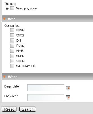
6 EUC1: Search Where? Bounding Box on a map What? Full text search (P031) SeaDataNet Agreed Parameter Groups Who? Product originator When? Period of interest

7 EUC1: Search
8 EUC1: View product description Details about the product description content will be defined, inputs considered are: Requirement from SeaDataNet (e.g. product s definitions) Information available from DIVA Profiles defined for EMODNET and MyOCEAN for similar objects. INSPIRE and other SeaDataNet ISO profiles (CSR, CDI) Nice dedicated look and feel can be plugged into the system (to be defined) Portal to external actions : view, download,
9 EUC1: View the product description
10 EUC1: View the product description Get pdf catalogue
11 EUC1: View the product description Get pdf catalogue See detailed desc


12 EUC1: View the product description Get pdf catalogue See detailed desc Extra action (view, download)
 And the")
13 EUC1: Jump to viewer From the product description, the user can jump to the ad hoc directory in the oceanbrowser (where DIVA datasets are uploaded and available) And the other way back
14 EUC2: interoperability and INSPIRE Discovery service: OGC/CSW protocol with ISO19139 profile service. INSPIRE compliant. Completed with: Visualization services (OGC/WMS) with OceanBrowser for gridded datasets and oceanotron for collections of observations. Download services (as R&D)
15 IUC1: Update metadata Operations done at IFREMER or CLS, Brest (as for EMODNET and MyOCean) DIVA to geonetwork : DIVA automatically creates a full product description (abstract, parameters, extents, vertical levels, originator ) uploaded to the catalogue. If needed manual editing Manual editing Online forms are provided. A workflow (validation from WP10) is implemented. Harvesting

16 EUC3 (bonus) : Cite products in scientific EUC3 publications
17 Connected features Visualization of collections (non gridded) : Oceanotron provides WMS service (to be consolidated within myocean v3, by the end of the year) Development of Oceanotron/storageUnit dedicated to SeaDataNet datasets is planned by the end of the year. Download FTP is a pragmatic option for download without subsetting Challenging issues : find a shared standard, for both gridded and non gridded datasets, enabling download with subsetting (compliance with INSPIRE also considered)
18 Schedule, tasks iso19139 profile definition : 12/2012 (IFREMER/GHER) DIVA to geonetworks ISO19139 : 12/2012 (GHER/IFREMER) forms development : 02/2013 (IFREMER) web integration in seadatanet (catalogue+ editorial + oceanbrowser): 04/2013 (IFREMER+GHER) Feed systems with products (INGV): First catalogue release : 05-09/2013 (Month 20 24) Final catalogue release : 05-09/2015 (month 42 46) R&D : download, visualisation of collections (non gridded) (IFREMER)
Data discovery and access via the SeaDataNet CDI system
 Data discovery and access via the SeaDataNet CDI system Central dataproducts and data services on distributed data. Peter Thijsse MARIS CLIPC IS-ENES workshop, KNMI, November 2014 Outline 1. Introduction
SeaDataNet, Pan-European infrastructure for marine ands ocean data management + EMODNET Preparatory Action Hydrographic and Seabed Mapping
 SeaDataNet, Pan-European infrastructure for marine ands ocean data management + EMODNET Preparatory Action Hydrographic and Seabed Mapping By Dick M.A. Schaap Technical Coordinator SeaDataNet & Coordinator
EMODnet Bathymetry. By Dick M.A. Schaap Coordinator. 20 th April 2016, EGU 2016, Vienna - Austria
 EMODnet Bathymetry By Dick M.A. Schaap Coordinator 20 th April 2016, EGU 2016, Vienna - Austria EMODNet Bathymetry Ongoing in 3 consecutive projects since 2009 with expanding consortium (at present >30
SeaDataNet, Pan-European infrastructure for marine and ocean data management + EMODNET
 SeaDataNet, Pan-European infrastructure for marine and ocean data management + EMODNET By Dick M.A. Schaap Technical Coordinator SeaDataNet & Coordinator EMODNet Bathymetry San Francisco USA, 13 December
Metadata for Data Discovery: The NERC Data Catalogue Service. Steve Donegan
 Metadata for Data Discovery: The NERC Data Catalogue Service Steve Donegan Introduction NERC, Science and Data Centres NERC Discovery Metadata The Data Catalogue Service NERC Data Services Case study:
SeaDataNet, Pan-European infrastructure for marine and ocean data management + EMODNET Bathymetry
 SeaDataNet, Pan-European infrastructure for marine and ocean data management + EMODNET Bathymetry By Dick M.A. Schaap Technical Coordinator SeaDataNet & Coordinator EMODNet Bathymetry Limassol Cyprus,
Compass INSPIRE Services. Compass INSPIRE Services. White Paper Compass Informatics Limited Block 8, Blackrock Business
 Compass INSPIRE Services White Paper 2010 Compass INSPIRE Services Compass Informatics Limited Block 8, Blackrock Business Park, Carysfort Avenue, Blackrock, County Dublin, Ireland Contact Us: +353 1 2104580
Geo Seas A pan European infrastructure for the management of marine geological and geophysical data
 Geo Seas A pan European infrastructure for the management of marine geological and geophysical data Colin Graham (BGS), Dick Schaap (MARIS), Paolo Diviacco (OGS) & Helen Glaves (BGS) Integrated Infrastructure
Towards a pan-european infrastructure for marine and ocean data management + Importance of standards
 Towards a pan-european infrastructure for marine and ocean data management + Importance of standards By Dick M.A. Schaap MARIS Technical Coordinator SeaDataNet & ODIP Coordinator EMODnet Bathymetry Münster
SeaDataNet, Pan-European infrastructure for ocean and marine data management & EMODNET Preparatory Actions Hydrographic Lot
 SeaDataNet, Pan-European infrastructure for ocean and marine data management & EMODNET Preparatory Actions Hydrographic Lot By Dick M.A. Schaap MARIS Brest, Sept 2009, GEBCO Science Day Supported by the
GeoDCAT-AP Representing geographic metadata by using the "DCAT application profile for data portals in Europe"
 GeoDCAT-AP Representing geographic metadata by using the "DCAT application profile for data portals in Europe" Andrea Perego, Vlado Cetl, Anders Friis-Christensen, Michael Lutz, Lorena Hernandez Joint
European Marine Data Exchange
 European Marine Data Exchange By Dick M.A. Schaap MARIS (NL) EU SeaDataNet Technical Coordinator EU EMODnet Ingestion Coordinator Noordzeedagen 2018 - October 2018 Acquisition of ocean and marine data
Pan-European infrastructure for management of marine and ocean geological and geophysical data Geo-Seas portal Data Discovery and Access Service
 Pan-European infrastructure for management of marine and ocean geological and geophysical data Geo-Seas Data Discovery and Access Service By Kathrin Manolis BGR and Dick M.A. Schaap Geo-Seas Technical
Towards a pan-european infrastructure for marine and ocean data management + Importance of standards
 Towards a pan-european infrastructure for marine and ocean data management + Importance of standards By Dick M.A. Schaap Technical Coordinator SeaDataNet & Coordinator EMODnet Bathymetry Hydrography Day,
Introduction of SeaDataNet and EMODNET Working towards a harmonised data infrastructure for marine data. Peter Thijsse MARIS
 Introduction of SeaDataNet and EMODNET Working towards a harmonised data infrastructure for marine data Peter Thijsse MARIS CLIPC & IS-ENES 2 workshop, KNMI, November 2014 Outline 1. Introduction to marine
FP7-INFRASTRUCTURES Grant Agreement no Scoping Study for a pan-european Geological Data Infrastructure D 4.4
 FP7-INFRASTRUCTURES-2012-1 Grant Agreement no. 312845 Scoping Study for a pan-european Geological Data Infrastructure D 4.4 Report on recommendations for implementation of the EGDI Deliverable number D4.4
The European Commission s science and knowledge service. Joint Research Centre
 The European Commission s science and knowledge service Joint Research Centre GeoDCAT-AP The story so far Andrea Perego, Antonio Rotundo, Lieven Raes GeoDCAT-AP Webinar 6 June 2018 What is GeoDCAT-AP Geospatial
Technical implementation plan for next period
 Technical implementation plan for next period Dick MA Schaap SeaDataCloud Technical Coordinator SDC Review, Brussels Belgium, 6 December 2018 Technical development lines Upgrading of CDI service Developing
The Scottish Spatial Data Infrastructure (SSDI)
") The Scottish Spatial Data Infrastructure (SSDI) INSPIRE Conference Istanbul Monday 25 th June 2012 15:55 Geoportals and registries II Tim Duffy BGS Edinburgh (trd@bgs.ac.uk) Shona Nicol Alex Ramage NERC
The Scottish Spatial Data Infrastructure (SSDI) INSPIRE Conference Istanbul Monday 25 th June 2012 15:55 Geoportals and registries II Tim Duffy BGS Edinburgh (trd@bgs.ac.uk) Shona Nicol Alex Ramage NERC
Webservice-energy.org GEO Community Portal & Spatial Data Infrastructure for Energy
 Webservice-energy.org GEO Community Portal & Spatial Data Infrastructure for Energy Lionel Menard / Oct. 23 2017 Centre Observation, Impacts, Energy Research activities: Use of Earth observation data (Models,
Initial Operating Capability & The INSPIRE Community Geoportal
 INSPIRE Conference, Rotterdam, 15 19 June 2009 1 Infrastructure for Spatial Information in the European Community Initial Operating Capability & The INSPIRE Community Geoportal EC INSPIRE GEOPORTAL TEAM
INSPIRE Conference 2018 (18 21 September, Antwerp)
") INSPIRE Conference 2018 (18 21 September, Antwerp) Introduction The Marine Strategy Framework Directive (MSFD) of the European Commission defines some obligations for the implementation of strategies for
INSPIRE Conference 2018 (18 21 September, Antwerp) Introduction The Marine Strategy Framework Directive (MSFD) of the European Commission defines some obligations for the implementation of strategies for
Description. Speaker Patrizia Monteduro (International Consultant, FAO) TRAINING GEONETWORK OPENSOURCE Islamabad, Pakistan, Jan 29-31, 2014
 TRAINING GEONETWORK OPENSOURCE Islamabad, Pakistan, Jan 29-31, 2014") BUILDING PROVINCIAL CAPACITY IN PAKISTAN FOR CROP ESTIMATION, FORECASTING, AND REPORTING BASED ON THE INTEGRATED USE OF REMOTELY SENSED DATA (GCP/PAK/125/USA) Description Speaker Patrizia Monteduro (International
BUILDING PROVINCIAL CAPACITY IN PAKISTAN FOR CROP ESTIMATION, FORECASTING, AND REPORTING BASED ON THE INTEGRATED USE OF REMOTELY SENSED DATA (GCP/PAK/125/USA) Description Speaker Patrizia Monteduro (International
The French Geoportal : linking discovery and view network services. INSPIRE Conference Krakow
 The French Geoportal : linking discovery and view network services ( BRGM ) D.Richard (IGN) F. Robida Context of the French Geoportal The governance mechanism Transversal organisation based on the Ministry
INSPIRE & Environment Data in the EU
 INSPIRE & Environment Data in the EU Andrea Perego Research Data infrastructures for Environmental related Societal Challenges Workshop @ pre-rda P6 Workshops, Paris 22 September 2015 INSPIRE in a nutshell
Increasing dataset quality metadata presence: Quality focused metadata editor and catalogue queriables.
 Increasing dataset quality metadata presence: Quality focused metadata editor and catalogue queriables. Alaitz Zabala (UAB), Joan Masó (CREAF), Lucy Bastin (ASTON), Fabrizio Papeschi (CNR), Eva Sevillano
Publishable summary for SeaDataNet III
 -1- Publishable summary for SeaDataNet III Executive summary. (The length of this part cannot exceed 1 page) SeaDataNet is the leading network in Europe, actively operating and developing a pan- European
PortalU, a Tool to Support the Implementation of the Shared Environmental Information System (SEIS) in Germany
 in Germany") European conference of the Czech Presidency of the Council of the EU TOWARDS eenvironment Opportunities of SEIS and SISE: Integrating Environmental Knowledge in Europe http:/www.e-envi2009.org/proceedings/
European conference of the Czech Presidency of the Council of the EU TOWARDS eenvironment Opportunities of SEIS and SISE: Integrating Environmental Knowledge in Europe http:/www.e-envi2009.org/proceedings/
Global Cryosphere Watch. GCW web portal Structure and demonstration
 Global Cryosphere Watch GCW web portal Structure and demonstration Øystein Godøy The high level purpose The GCW web portal will make GCW data and information available to WMO Members, their partners, and
GENeric European Sustainable Information Space for Environment.
 GENeric European Sustainable Information Space for Environment http://www.genesis-fp7.eu/ Outline Introduction The GENESIS FP7 project The GENESIS solution s architecture GENESIS experience with INSPIRE
Transboundary data interoperability for Maritime Spatial Planning. Yuji KATO
 Transboundary data interoperability for Maritime Spatial Planning Yuji KATO CONTEXT THE MARITIME SPATIAL PLANNING DIRECTIVE DIRECTIVE 2014/89/EU establishing a framework for Maritime Spatial Planning (MSP)
Deliverable D3.12. Contract number: OJEU 2010/S Deliverable: D3.12 Author: Igor Antolovic Date: Version: Final
 Deliverable D3.12 Final and public version of the implemented web site with full functionality that hosts all relevant information on the Climate Atlas of the Carpathian Region, including a public download
SeaDataNet, EMODnet and Operational Oceanography in the Adriatic
 SeaDataNet, EMODnet and Operational Oceanography in the Adriatic G.M.R. Manzella 2/45 Data is being used by a far broader community than ever before; Metadata are critical for recording the provenance
OceanBrowser: on-line visualization of gridded ocean data and in situ observations
 OceanBrowser: on-line visualization of gridded ocean data and in situ observations Alexander Barth¹, Sylvain Watelet¹, Charles Troupin², Aida Alvera Azcarate¹, Giorgio Santinelli³, Gerrit Hendriksen³,
SAFER the GIGAS Effect
 SAFER the GIGAS Effect How INSPIRE, GMES and GEOSS are influencing EC projects Arnaud Cauchy 23/06/2010 Agenda GIGAS Project Summary SAFER Project Summary SAFER Original Approach GIGAS Influences SAFER
EarthLookCZ as Czech way to GMES
 EarthLookCZ as Czech way to GMES Karel Charvat 1 and Petr Horak 1 1 WirelessInfo, Czech Republic, charvat@wirelessinfo.cz Abstract Global Monitoring for Environment and Security is one of 4 ranges of solutions
h p://seadatanet.maris2.nl/newsle er.asp?v0=6
 1 sur 26 20/02/2012 16:15 Newsle er Content: 15 March 2011 Foreword SeaDataNet - present status and new features Geo-Seas project, extending SeaDataNet to marine geology and geophysics EMODNet Hydrography
Introduction to INSPIRE. Network Services
 Introduction to INSPIRE. Network Services European Commission Joint Research Centre Institute for Environment and Sustainability Digital Earth and Reference Data Unit www.jrc.ec.europa.eu Serving society
Basic Principles of MedWIS - WISE interoperability
 Co-ordination committee seminar of the national focal points Basic Principles of MedWIS - WISE interoperability Eduardo García ADASA Sistemas Nice - France Agenda WISE vs MedWIS WISE WISE DS WISE vs WISE
Relation between Geospatial information projects related to GBIF
 Relation between Geospatial information projects related to GBIF Synthesys 3.6-Synthesys 3.7-GBIF.DE- BioGeomancer The most up to date work can always be found at: http://www.biogeografia.com/synthesys
Leveraging metadata standards in ArcGIS to support Interoperability. Aleta Vienneau and Marten Hogeweg
 Leveraging metadata standards in ArcGIS to support Interoperability Aleta Vienneau and Marten Hogeweg Leveraging metadata standards in ArcGIS to support Interoperability Overview of metadata standards
Knowledge Inventory for hydrogeology research
 Knowledge Inventory for hydrogeology research This project has received funding from the European Union s Horizon 2020 research and innovation programme under grant agreement No 642047. REDIAM Environmental
The UK Marine Environmental Data and Information Network MEDIN
 The UK Marine Environmental Data and Information Network MEDIN M. Charlesworth, R. Lowry, H. Freeman, J. Rapaport, B Seeley Content MEDIN - a brief overview for context Discovery Metadata Standard and
GeoNetwork User Manual
 GeoNetwork User Manual Release 2.10.4-0 GeoNetwork December 08, 2017 Contents 1 Preface 3 1.1 About this Project............................................ 3 1.2 License Information...........................................
Sharing geographic data across the GEF IW Portfolio: IW:LEARN Web-based GIS
 1 Sharing geographic data across the GEF IW Portfolio: IW:LEARN Web-based GIS 16-22 March 2009 Sean Khan (Project Manager) sean.khan@unep.org Dr. Richard Cooper (Regional Coordinator) richard@iwlearn.org
Integration of INSPIRE & SDMX data infrastructures for the 2021 population and housing census
 Integration of INSPIRE & SDMX data infrastructures for the 2021 population and housing census Nadezhda VLAHOVA, Fabian BACH, Ekkehard PETRI *, Vlado CETL, Hannes REUTER European Commission (*ekkehard.petri@ec.europa.eu
GeoNetwork User Manual
 GeoNetwork User Manual Release 2.10.4-0 GeoNetwork December 22, 2014 Contents 1 Preface 3 1.1 About this Project..................................... 3 1.2 License Information....................................
The EOC Geoservice: Standardized Access to Earth Observation Data Sets and Value Added Products ABSTRACT
 The EOC Geoservice: Standardized Access to Earth Observation Data Sets and Value Added Products K. Dengler, T. Heinen, A. Huber, K. Molch, E. Mikusch German Aerospace Center (DLR) German Remote Sensing
Title: Author(s)/Organisation(s): Working Group: References: Quality Assurance: A5.2-D3 [3.7] Information Grounding Service Component Specification
![Title: Author(s)/Organisation(s): Working Group: References: Quality Assurance: A5.2-D3 [3.7] Information Grounding Service Component Specification](/thumbs/80/81830659.jpg "Title: Author(s)/Organisation(s): Working Group: References: Quality Assurance: A5.2-D3 [3.7] Information Grounding Service Component Specification") Title: A5.2-D3 [3.7] Information Grounding Service Component Specification Author(s)/Organisation(s): Ana Belén Antón/ETRA Working Group: Architecture Team/WP05 References: A1.8-D5 User Involvement Document,
Title: A5.2-D3 [3.7] Information Grounding Service Component Specification Author(s)/Organisation(s): Ana Belén Antón/ETRA Working Group: Architecture Team/WP05 References: A1.8-D5 User Involvement Document,
Alexander Barth, Aida Alvera-Azcárate, Mohamed Ouberdous, Charles Troupin, Sylvain Watelet & Jean-Marie Beckers
 Diva workshop 2014 Diva in 4 dimensions (GODIVA) Alexander Barth, Aida Alvera-Azcárate, Mohamed Ouberdous, Charles Troupin, Sylvain Watelet & Jean-Marie Beckers Acknowledgements: SeaDataNet, EMODnet Chemistry,
The GeoPortal Cookbook Tutorial
 The GeoPortal Cookbook Tutorial Wim Hugo SAEON/ SAEOS SCOPE OF DISCUSSION Background and Additional Resources Context and Concepts The Main Components of a GeoPortal Architecture Implementation Options
C3S Data Portal: Setting the scene
 C3S Data Portal: Setting the scene Baudouin Raoult Baudouin.raoult@ecmwf.int Funded by the European Union Implemented by Evaluation & QC function from European commission e.g.,fp7 Space call Selected set
Risk Habitat Megacity
 Contact Internet: Coordination: Data management: www.risk-habitat-megacity.ufz.de Dr. Dirk Heinrichs [dirk.heinrichs@ufz.de] Dr. Kerstin Krellenberg [kerstin.krellenberg@ufz.de] Christian Gadge [christian.gadge@ufz.de]
B2FIND and Metadata Quality
 B2FIND and Metadata Quality 3 rd EUDAT Conference 25 September 2014 Heinrich Widmann and B2FIND team 1 Outline B2FIND the EUDAT Metadata Service Semantic Mapping of Metadata Quality of Metadata Summary
INSPIRE overview and possible applications for IED and E-PRTR e- Reporting Alexander Kotsev
 INSPIRE overview and possible applications for IED and E-PRTR e- Reporting Alexander Kotsev www.jrc.ec.europa.eu Serving society Stimulating innovation Supporting legislation The European data puzzle 24
METAINFORMATION INFRASTRUCTURE FOR GEOSPATIAL INFORMATION
 2010/2 PAGES 1 7 RECEIVED 15. 6. 2009 ACCEPTED 2. 3. 2010 T. KLIMENT METAINFORMATION INFRASTRUCTURE FOR GEOSPATIAL INFORMATION ABSTRACT Tomáš KLIMENT email: tomas.kliment@stuba.sk Research field: Spatial
Metadata - Inspire content - registration - services
 Metadata - Inspire content - registration - services Nordic Forum for Geostatistics Sept 2007 Arvid Lillethun, Norwegian Mapping and Cadaster Authority Web map service (WMS) Web feature service (WFS) Web
Long-term preservation for INSPIRE: a metadata framework and geo-portal implementation
 Long-term preservation for INSPIRE: a metadata framework and geo-portal implementation INSPIRE 2010, KRAKOW Dr. Arif Shaon, Dr. Andrew Woolf (e-science, Science and Technology Facilities Council, UK) 3
Guidelines for metadata, data and DTM QA/QC
 European Marine Observation and Data Network Guidelines for metadata, data and DTM QA/QC Service Contract for Lot 1 Bathymetry Modifications Version Date Authors Comments 1.0 2009/12/03 P. Hunter, B. Loubrieu,
Discovery and Access of Geospatial Resources Using GIS Portal Toolkit Marten Hogeweg Product Manager GIS Portal Toolkit
 Discovery and Access of Geospatial Resources Using GIS Portal Toolkit Marten Hogeweg Product Manager GIS Portal Toolkit Outline Elements of Spatial Data Infrastructures Current trends Position of GIS portals
How to become an INSPIRE node and fully exploit the investments made?
 How to become an INSPIRE node and fully exploit the investments made? Solution patterns for consumers: end users & developers (2/2) Roberto Lucchi 22 June 2010, Krakow 1 Geoportal extension Enabling discovery
INSPIRE Geoportal Rich user experience across member states services
 INSPIRE Geoportal Rich user experience across member states services developed under a contract with the EC (JRC) Diomede ILLUZZI 1 Nicola LUNANOVA 1 Torsten FRIEBE 2 1 Planetek Italia s.r.l Via Masaua
GeoNetwork User Manual
 GeoNetwork User Manual Release 2.6.4 GeoNetwork April 05, 2012 Contents 1 Preface 3 1.1 About this Project..................................... 3 1.2 License Information....................................
Enabling Efficient Discovery of and Access to Spatial Data Services. CHARVAT, Karel, et al. Abstract
 Article Enabling Efficient Discovery of and Access to Spatial Data Services CHARVAT, Karel, et al. Abstract Spatial data represent valuable information and a basis for decision making processes in society.
EUDAT-B2FIND A FAIR and Interdisciplinary Discovery Portal for Research Data
 EUDAT-B2FIND A FAIR and Interdisciplinary Discovery Portal for Research Data Heinrich Widmann, DKRZ Claudia Martens, DKRZ Open Science Days, Berlin, 17 October 2017 www.eudat.eu EUDAT receives funding
Metadata of geographic information
 Metadata of geographic information Kai Koistinen Management of environmental data and information 4.10.2017 Topics Metadata of geographic information What is metadata? Metadata standards and recommendations
EUDAT B2FIND A Cross-Discipline Metadata Service and Discovery Portal
 EUDAT B2FIND A Cross-Discipline Metadata Service and Discovery Portal Heinrich Widmann, DKRZ DI4R 2016, Krakow, 28 September 2016 www.eudat.eu EUDAT receives funding from the European Union's Horizon 2020
IMOS/AODN ocean portal: tools for data delivery. Roger Proctor, Peter Blain, Sebastien Mancini IMOS
 IMOS/AODN ocean portal: tools for data delivery Roger Proctor, Peter Blain, Sebastien Mancini IMOS Data from IMOS: The six Nodes Bluewater and Climate Node open ocean focus Five Regional Nodes continental
OGC at KNMI: Current use and plans
 OGC at KNMI: Current use and plans 4th Workshop on the use of GIS/OGC standards in meteorology 4 th of March 2013, Reading 1. Ernst de Vreede 2. Maarten Plieger Contents 1. ADAGUC 2. Internal applications
The complete manual. By the developers. V 2.4 Copyright The Open Source Geospatial Foundation
 The complete manual By the developers V 2.4 Copyright 2007-2009 The Open Source Geospatial Foundation Table of Contents Preface... vi I. User Guide... 1 1. A Geographic Information Management System for
INSPIRE: The ESRI Vision. Tina Hahn, GIS Consultant, ESRI(UK) Miguel Paredes, GIS Consultant, ESRI(UK)
 Miguel Paredes, GIS Consultant, ESRI(UK)") INSPIRE: The ESRI Vision Tina Hahn, GIS Consultant, ESRI(UK) Miguel Paredes, GIS Consultant, ESRI(UK) Overview Who are we? Introduction to ESRI Inc. and ESRI(UK) Presenters ArcGIS The ESRI Solution to
INSPIRE: The ESRI Vision Tina Hahn, GIS Consultant, ESRI(UK) Miguel Paredes, GIS Consultant, ESRI(UK) Overview Who are we? Introduction to ESRI Inc. and ESRI(UK) Presenters ArcGIS The ESRI Solution to
Esri Geoportal Server
 Esri Geoportal Server Implementing a Spatial Data Infrastructure @martenhogeweg Esri Geoportal Server Extending ArcGIS to enable discovery and use of geospatial resources in heterogeneous environments
The geospatial metadata catalogue. FOSS4G Barcelona. Jeroen Ticheler. Founder and chair. Director
 The geospatial metadata catalogue FOSS4G2010 - Barcelona Jeroen Ticheler Director Founder and chair GeoNetwork opensource Dutch National Geo Registry FAO GeoNetwork SwissTopo geocat.ch GeoNetwork history
OpenData and INSPIRE with GeoServer, GeoNetwork and MapStore: lessons learned from real-world use cases
 OpenData and INSPIRE with GeoServer, GeoNetwork and MapStore: lessons learned from real-world use cases Ing. Simone Giannecchini, GeoSolutions Silvana Griffa, CSI Piemonte Giovanni Menduni, City of Florence
The EU-UMKDP (Urban Mining Knowledge Data Platform)
") ProSUM The EU-UMKDP (Urban Mining Knowledge Data Platform) 23 rd April 2015 ProSUM rmation Network 1 st Meeting, Hotel Bloom, Brussels Daniel Cassard and the WP5 Team BRGM, CBS, CGS, Chalmers, C-tech,
ProSUM The EU-UMKDP (Urban Mining Knowledge Data Platform) 23 rd April 2015 ProSUM rmation Network 1 st Meeting, Hotel Bloom, Brussels Daniel Cassard and the WP5 Team BRGM, CBS, CGS, Chalmers, C-tech,
 http://ipafloods.mydewetra.org 1 My Dewetra IPA FLOODS FLOOD RISK Information System Support the Approximation of EU Floods Directive Compliancy with International standards (INSPIRE, OGC) and protocols
MY DEWETRA IPAFLOODS REPORT
 Grant Contract N. ECHO/SUB/2014/692292 Programme for Prevention, Preparedness and Response to Floods in the Western Balkans and Turkey IPA FLOODS Capacity Building Activities 2016 MY DEWETRA IPAFLOODS
Capturing ICAN end-user requirements for NETMAR
 Capturing ICAN end-user requirements for NETMAR Declan Dunne, CMRC d.dunne@ucc.ie ICAN Workshop 5, Oostende, 31 August - 2 September 2011 Outline! User Feedback! Geo-processing services! Cookbooks 2 User
ERDAS APOLLO Managing and Serving Geospatial Information
 ERDAS APOLLO Managing and Serving Geospatial Information ERDAS APOLLO Do you have large volumes of geospatial information, regularly updated data stores, and a distributed user base? Do you need a single,
/// INTEROPERABILITY BETWEEN METADATA STANDARDS: A REFERENCE IMPLEMENTATION FOR METADATA CATALOGUES
 /// Position Paper /// INTEROPERABILITY BETWEEN METADATA STANDARDS: A REFERENCE IMPLEMENTATION FOR METADATA CATALOGUES /// Keywords: Public administration, Metadata, Geographical Information, Geospatial
GeoPortal 4 Everybody
 GeoPortal 4 Everybody Karel Charvát, Jáchym Čepický, Štěpán Kafka, Premysl Vohnout, Martin Vlk Czech Centre for Science and Society Help Service Remote Sensing DT Member What is GeoPortal GeoPortal is
SEIS. (Shared Environmental Information System) From concept to information services
 From concept to information services") SEIS (Shared Environmental Information System) From concept to information services Stefan Jensen EEA supported by Sheila Cryan and Jon Maidens GSDI 11, Rotterdam 19.6.2009 What is SEIS is about... Sharing
SEIS (Shared Environmental Information System) From concept to information services Stefan Jensen EEA supported by Sheila Cryan and Jon Maidens GSDI 11, Rotterdam 19.6.2009 What is SEIS is about... Sharing
Contents. Introduction. CDI V3 Help Quick Search
 Contents Introduction... 1 A The interface... 2 A-1 Introduction... 2 A-2. Results list... 2 A-3: Additional menu options... 3 B. Searching the CDI entries metadata... 4 B-1 Narrowing down your result
SEXTANT 1. Purpose of the Application
 SEXTANT 1. Purpose of the Application Sextant has been used in the domains of Earth Observation and Environment by presenting its browsing and visualization capabilities using a number of link geospatial
MAKING INSPIRE DATA DISCOVERABLE AND FINDABLE THROUGH POPULAR SEARCH ENGINES
 MAKING INSPIRE DATA DISCOVERABLE AND FINDABLE THROUGH POPULAR SEARCH ENGINES EXPERIMENTATION ON FRENCH GEOCATALOGUE A FELIACHI, S GRELLET AND TVILMUS IT CONTEXT BRGM, French geological survey, is implementing
eresearch Collaboration across the Pacific:
 eresearch Collaboration across the Pacific: Marine Systems and Australian Marine Science Craig Johnson University of Tasmania Outline Introduce the Australian Ocean Network Possibilities for trans-pacific
Multi-disciplinary Interoperability: the EuroGEOSS Operating Capacities
 Multi-disciplinary Interoperability: the EuroGEOSS Operating Capacities Stefano Nativi (CNR) stefano.nativi@cnr.it Opening and context for Global Dimension Stream: EuroGEOSS contribution to the Global
EUDAT & SeaDataCloud
 EUDAT & SeaDataCloud SeaDataCloud Kick-off meeting Damien Lecarpentier CSC-IT Center for Science www.eudat.eu EUDAT receives funding from the European Union's Horizon 2020 programme - DG CONNECT e-infrastructures.
Experience federating the metadata catalogue of IGN in the Spanish Open Data Portal
 Experience federating the metadata catalogue of IGN in the Spanish Open Data Portal Paloma Abad E. López, A.F. Rodríguez, A. Sánchez, S. Castro, S. Soriano, J.I Sánchez 1 Summary IGN Metadata Catalogue
Understanding and Using Metadata in ArcGIS. Adam Martin Marten Hogeweg Aleta Vienneau
 Understanding and Using Metadata in ArcGIS Adam Martin Marten Hogeweg Aleta Vienneau Adam Martin National Government Account Management R&D Open Data Marten Hogeweg National Government Professional Services
Impacts of the new standard for metadata on geographic information (ISO :2014) on an INSPIRE discovery service
 on an INSPIRE discovery service") Impacts of the new standard for metadata on geographic information (ISO 19115-1:2014) on an INSPIRE discovery service Describing the process of migrating from an ISO19115 regional profile in Wallonia to
Impacts of the new standard for metadata on geographic information (ISO 19115-1:2014) on an INSPIRE discovery service Describing the process of migrating from an ISO19115 regional profile in Wallonia to
Evolution of INSPIRE interoperability solutions for e-government
 Evolution of INSPIRE interoperability solutions for e-government INSPIRE Implementation State-of-Play 26/05/2015 Robin S. Smith www.jrc.ec.europa.eu Serving society Stimulating innovation Supporting legislation
Consolidation Team INSPIRE Annex I data specifications testing Call for Participation
 INSPIRE Infrastructure for Spatial Information in Europe Technical documents Consolidation Team INSPIRE Annex I data specifications testing Call for Participation Title INSPIRE Annex I data specifications
Implementing GeoDRM support in an OpenLayers based viewer Access to the French geoportal WMS-C services from the Spanish SDI
 INSPIRE Conference 2011 Implementing GeoDRM support in an OpenLayers based viewer Access to the French geoportal WMS-C services from the Spanish SDI R. Béjar, M. Á. Latre, J. Valiño, F. Javier Zarazaga-Soria,
GeoNode Integration with SDIs and Community Mapping
 GeoNode Integration with SDIs and Community Mapping Salvador Bayarri sbayarri@gmail.com World Bank Consultant Contents Accessing other SDI services Catalog harvesting through Geonetwork Cascading external
The European Soil Data Centre, the European Soil Bureau Network and INSPIRE Data Specifications for Soil
 The European Soil Data Centre, the European Soil Bureau Network and INSPIRE Data Specifications for Soil Marc Van Liedekerke, Panos Panagos, Luca Montanarella Land Management and Natural Harzards Unit
(Geo)DCAT-AP Status, Usage, Implementation Guidelines, Extensions
DCAT-AP Status, Usage, Implementation Guidelines, Extensions") (Geo)DCAT-AP Status, Usage, Implementation Guidelines, Extensions HMA-AWG Meeting ESRIN (Room D) 20. May 2016 Uwe Voges (con terra GmbH) GeoDCAT-AP European Data Portal European Data Portal (EDP): central
(Geo)DCAT-AP Status, Usage, Implementation Guidelines, Extensions HMA-AWG Meeting ESRIN (Room D) 20. May 2016 Uwe Voges (con terra GmbH) GeoDCAT-AP European Data Portal European Data Portal (EDP): central
Desarrollo de una herramienta de visualización de datos oceanográficos: Modelos y Observaciones
 Desarrollo de una herramienta de visualización de datos oceanográficos: Modelos y Observaciones J. Fernandez, J. Lopez, I. Carlos, F. Jerez, F. Hermosilla, M. Espino SIMO, LIM-UPC, CIIRC FIELD_AC 7 th
Addressing Geospatial Big Data Management and Distribution Challenges ERDAS APOLLO & ECW
 Addressing Geospatial Big Data Management and Distribution Challenges ERDAS APOLLO & ECW Nouman Ahmed GeoSystems-Me (Hexagon Geospatial / ERDAS Regional Partner) Enterprise Solutions Architect Hexagon
Big Data Earth Observation Standardization elements Codrina Ilie TERRASIGNA TF7/SG5
 Big Data Earth Observation Standardization elements Codrina Ilie TERRASIGNA TF7/SG5 1 Earth Observation standardization intro 2 directions: 1. standardization of the Ground Segment Services: Heterogeneous