Coverage data model. Vector-Based Spatial Analysis: Tools Processes. Topological Data Model. Polygons Files. Geographic Information Systems.
|
|
|
- Marybeth Ryan
- 5 years ago
- Views:
Transcription


1 GEOG4340 Geographic Information Systems Lecture Four 2013winter Vector-Based Spatial Analysis: Tools Processes Reading materials: Chapter 6 of Intro GIS by J. R. Jensen and R.R. Jensen Cheng. Q., Earth and Space Science and Engineering, qiuming@yorku.ca Polygons Files Arcs Files Points Files Coordinate files Landuse.PAT Landuse.AAT Landuse.NAT Coordinate files Street.AAT Street.NAT Coordinate files Well.PAT Topological Data Model Feature attribute tables Point Attribute Table PAT Arc Attribute Table AAT Node Attribute Table NAT Polygon Attribute Table PAT Topological relationships Coverage data model A coverage is a data model for the storage of vector data. It generally represents a single set of geographic objects such as roads, parcels, soil units or forest stands in a given area. A coverage supports the georelational model it contains both the spatial (location) and attribute (descriptive) data for geographic features Label file Arc attribute tab Node attribute tab point locations Reference location


2 Shapefile data format Shapefile data format Shapefiles are a simple, non-topological format for storing vector data and attribute data. It generally represents a single set of geographic objects such as roads, parcels, soil units or forest stands in a given area. A shapefile does not support the georelational. Landuse.shp Landuse.shp Landuse.shx Landuse.dbf Landuse.dbf No shape id Map of same features Exchange file DBS file for attr. table Geodatabase Geodatabase of ArcGIS is object-based georelational spatial database. It works for storing vector data, attribute data and raster data. It generally represents multiple sets of geographic objects such as roads, parcels, soil units or forest stands in a given area and support the georelations among these sets Decision Spatial Analysis Support Knowledge Processes and Basic Tools Interpretation Information Processes GIS Database 2


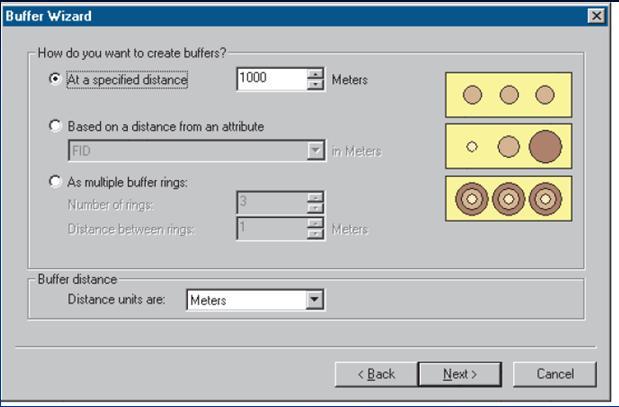
3 Example of geoprocessing Create Buffer Zones Around Vectors Points Lines Polygons ArcGIS Operation Layer A Layer B Operator Layer C Operator Layer 3

4 Node -Node relationship Node -Line relationship Spatial Join Spatial Join Points B Line B New Attribute Showing nearest Points on B from A New Attribute Showing nearest Points on B from A Node -Polygon relationship Line -Line relationship Line A Spatial Join Table Join Points C By shape Line B New Attribute Showing class of ions 4


5 Line -Poly relationship Line -Poly relationship Line A Line A Line C Point C New line layer With lines separated According to poly Class in New Point feature Of intersect of Line A and Poly -Poly relationship Poly Poly Poly A Poly A Poly C Line C Identity Union New Poly combined Poly A and New Line Feature Common boundary of Poly A and Poly Poly Application and Vector-based Analysis Site for Wastewater Treatment Plant Poly A Point C New Point Feature of Poly A and 5


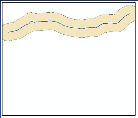
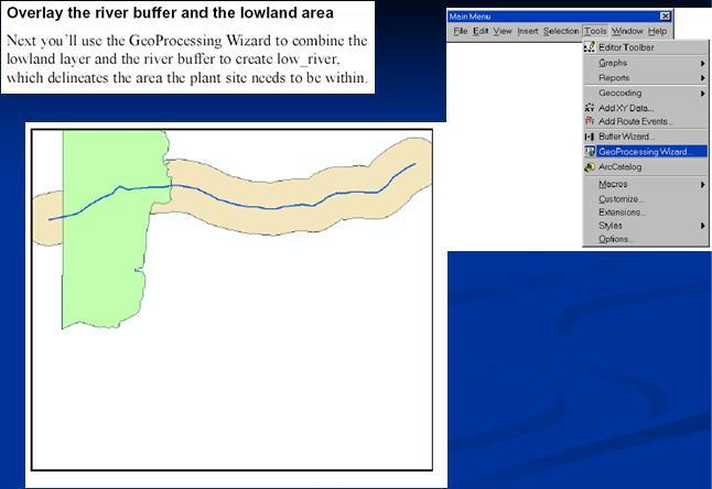
6 Model of Processes River Buffer R_Buffer Land Areas 6


7 7


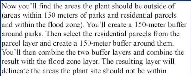
8 Parcel Select Residential Selected P Buffer 150m Res_Buf Park Buffer 150m P_Buffer Union Res_Park Flood_Z Union R_P_Flood 8


9 9
Object modeling and geodatabases. GEOG 419: Advanced GIS
 Object modeling and geodatabases GEOG 419: Advanced GIS CAD Data Model 1960s and 1970s Geographic data stored as points, lines, and areas No attributes; each feature type stored on a different layer No
Copyright The McGraw-Hill Companies, Inc. Permission required for reproduction or display.
 Chapter 8. ATTRIBUTE DATA INPUT AND MANAGEMENT 8.1 Attribute Data in GIS 8.1.1 Type of Attribute Table 8.1.2 Database Management 8.1.3 Type of Attribute Data Box 8.1 Categorical and Numeric Data 8.2 The
Key Terms. Attribute join Target table Join table Spatial join
 Key Terms Attribute join Target table Join table Spatial join Lect 10A Building Geodatabase Create a new file geodatabase Map x,y data Convert shape files to geodatabase feature classes Spatial Data Formats
Introduction to Geodatabase and Spatial Management in ArcGIS. Craig Gillgrass Esri
 Introduction to Geodatabase and Spatial Management in ArcGIS Craig Gillgrass Esri Session Path The Geodatabase - What is it? - Why use it? - What types are there? - What can I do with it? Query Layers
Class #2. Data Models: maps as models of reality, geographical and attribute measurement & vector and raster (and other) data structures
 data structures") Class #2 Data Models: maps as models of reality, geographical and attribute measurement & vector and raster (and other) data structures Role of a Data Model Levels of Data Model Abstraction GIS as Digital
Class #2 Data Models: maps as models of reality, geographical and attribute measurement & vector and raster (and other) data structures Role of a Data Model Levels of Data Model Abstraction GIS as Digital
Unit 3: Proximity Analysis and Buffering. Lecture Outline
 Unit 3: Proximity Analysis and Buffering Lecture Outline I. Vector-Based Proximity 1. Proximity involves the calculation of distance between features in a single layer, or between features in multiple
Lab.4 & Assignment 2. Lab4. Conversion of Hardcopy Map to ArcGIS Map
 EATS4400 GIS Lab.4 & Assignment 2 Lab4 Conversion of Hardcopy Map to ArcGIS Map In this lab exercise you will have chance to go through the steps to convert hardcopy map into digital map for ArcGIS. Digitizing
Topic 5: Raster and Vector Data Models
 Geography 38/42:286 GIS 1 Topic 5: Raster and Vector Data Models Chapters 3 & 4: Chang (Chapter 4: DeMers) 1 The Nature of Geographic Data Most features or phenomena occur as either: discrete entities
Lecture 6: GIS Spatial Analysis. GE 118: INTRODUCTION TO GIS Engr. Meriam M. Santillan Caraga State University
 Lecture 6: GIS Spatial Analysis GE 118: INTRODUCTION TO GIS Engr. Meriam M. Santillan Caraga State University 1 Spatial Data It can be most simply defined as information that describes the distribution
GEOGRAPHIC INFORMATION SYSTEMS Lecture 17: Geoprocessing and Spatial Analysis
 GEOGRAPHIC INFORMATION SYSTEMS Lecture 17: and Spatial Analysis tools are commonly used tools that we normally use to prepare data for further analysis. In ArcMap, the most commonly used tools appear in
Streamlining Editing Workflows. Amber Bethell
 Streamlining Editing Workflows Amber Bethell Workflow for solving geographic problems Ask a question Create or acquire data Validate and update data Analyze data Create cartographic product Act upon knowledge
GIS Workshop Spring 2016
 1/ 14 GIS Geographic Information System. An integrated collection of computer software and data used to view and manage information about geographic places, analyze spatial relationships, and model spatial
Exercise 4 Compiling a Spatial Database: Adding and Linking Attribute Data
 Geog, IES 377/Cee 357 Exercise 4 Page: 1/9 GEOG 377/CEE 357: An Introduction to Geographic Information Systems Exercise 4 Compiling a Spatial Database: Adding and Linking Attribute Data 1. Introduction
SVY2001: Databases for GIS
 SVY2001: Databases for GIS Lecture 15: Introduction to GIS and Attribute Data Management. Dr Stuart Barr School of Civil Engineering & Geosciences University of Newcastle upon Tyne. Email: S.L.Barr@ncl.ac.uk
Geog, IES 377/Cee 357 Exercise 5 Page: 1/6. GEOG, IES 377/CEE 357: An Introduction to Geographic Information Systems
 Geog, IES 377/Cee 357 Exercise 5 Page: 1/6 1. Introduction: GEOG, IES 377/CEE 357: An Introduction to Geographic Information Systems Exercise 5 Compiling Spatial Database: Getting the other data layers
Mid-term exam. GIS and Forest Engineering Applications. Week 5. FE 257. GIS and Forest Engineering Applications. Week 5
 FE 257. GIS and Forest Engineering Applications Week 5 Week 5 Last week (Chapter 3): Acquiring, creating, and editing GIS s Examining Error Chapter 7 Buffering and other proximity operations Questions?
Welcome to NR402 GIS Applications in Natural Resources. This course consists of 9 lessons, including Power point presentations, demonstrations,
 Welcome to NR402 GIS Applications in Natural Resources. This course consists of 9 lessons, including Power point presentations, demonstrations, readings, and hands on GIS lab exercises. Following the last
ArcMap - EXPLORING THE DATABASE Part I. SPATIAL DATA FORMATS Part II
 Week 5 ArcMap - EXPLORING THE DATABASE Part I SPATIAL DATA FORMATS Part II topics of the week Exploring the Database More on the Table of Contents Exploration tools Identify, Find, Measure, Map tips, Hyperlink,
This support note will discuss several methods of creating no spray zones for Sentinel GIS>
 Reason Sentinel Adulticiding support a polygon no spray layer. Adulticiding mobile software warns the driver when they are approaching a no spray zone so they can turn off the sprayer. Because no spray
Analysis of Change in Polygon Distribution
 Analysis of Change in Polygon Distribution t 1 t 2 These instructions enable you to analyze the change in polygon distribution between two time periods using ArcGIS 8.1 (ArcInfo licensed) software. The
layers in a raster model
 layers in a raster model Layer 1 Layer 2 layers in an vector-based model (1) Layer 2 Layer 1 layers in an vector-based model (2) raster versus vector data model Raster model Vector model Simple data structure
GEOGRAPHIC INFORMATION SYSTEMS Lecture 18: Spatial Modeling
 Spatial Analysis in GIS (cont d) GEOGRAPHIC INFORMATION SYSTEMS Lecture 18: Spatial Modeling - the basic types of analysis that can be accomplished with a GIS are outlined in The Esri Guide to GIS Analysis
v SMS 11.1 Tutorial GIS Requirements GIS Module Map Module ArcGis (Optional) Time minutes Prerequisites None Objectives
 Time minutes Prerequisites None Objectives") v. 11.1 SMS 11.1 Tutorial GIS Objectives This tutorial demonstrates how you can read in GIS data, visualize it, and convert it into SMS coverage data that could be used to build a numeric model. We will
v. 11.1 SMS 11.1 Tutorial GIS Objectives This tutorial demonstrates how you can read in GIS data, visualize it, and convert it into SMS coverage data that could be used to build a numeric model. We will
GIS Data Models. 4/9/ GIS Data Models
 GIS Data Models 1 Conceptual models of the real world The real world can be described using two conceptually different models: 1. As discrete objects, possible to represent as points, lines or polygons.
Introduction to ArcCatalog
 Introduction to ArcCatalog Introduction To Arc Catalog ArcCatalog is a data- centric GUI tool used for managing spatial data With ArcCatalog you can. Inspect properties and attributes of data Preview and
LSGI 521: Principles of GIS. Lecture 5: Spatial Data Management in GIS. Dr. Bo Wu
 Lecture 5: Spatial Data Management in GIS Dr. Bo Wu lsbowu@polyu.edu.hk Department of Land Surveying & Geo-Informatics The Hong Kong Polytechnic University Contents 1. Learning outcomes 2. From files to
Measure the Perimeter of Polygons Over a Surface. Operations. What Do I Need?
 Measure the Perimeter of Polygons Over a Surface Operations What Do I Need? Incremental Frontage Score To measure the perimeter of polygons over a surface you need to have two input map layers. The first
ENGRG 59910: Introduction to GIS
 ENGRG 59910: Introduction to GIS Lecture 05: GIS and Databases Basics Acknowledgment: Michael Piasecki Where are we now? Basic geographic concepts Introduction to GIS, coordinate system, projection, datum
Lecture 7 Digitizing. Dr. Zhang Spring, 2017
 Lecture 7 Digitizing Dr. Zhang Spring, 2017 Model of the course Using and making maps Navigating GIS maps Map design Working with spatial data Geoprocessing Spatial data infrastructure Digitizing File
Lecture 8. Vector Data Analyses. Tomislav Sapic GIS Technologist Faculty of Natural Resources Management Lakehead University
 Lecture 8 Vector Data Analyses Tomislav Sapic GIS Technologist Faculty of Natural Resources Management Lakehead University Vector Data Analysis Vector data analysis involves one or a combination of: Measuring
A New Approach for Data Conversion from CAD to GIS
 Esin Bitik (PhD) Dursun Zafer Şeker Ziyadin ÇAKIR Hakan DENLİ A New Approach for Data Conversion from CAD to GIS June 19, 2014 Contents 1. Aim of the study 2. Introduction 3. Vector Data Structure 4. Converting
Name: Date: June 27th, 2011 GIS Boot Camps For Educators Lecture_3
 Name: Date: June 27th, 2011 GIS Boot Camps For Educators Lecture_3 Practical: Creating and Editing Shapefiles Using Straight, AutoComplete and Cut Polygon Tools Use ArcCatalog to copy data files from:
Explore some of the new functionality in ArcMap 10
 Explore some of the new functionality in ArcMap 10 Scenario In this exercise, imagine you are a GIS analyst working for Old Dominion University. Construction will begin shortly on renovation of the new
GEOGRAPHIC INFORMATION SYSTEMS Lecture 02: Feature Types and Data Models
 GEOGRAPHIC INFORMATION SYSTEMS Lecture 02: Feature Types and Data Models Feature Types and Data Models How Does a GIS Work? - a GIS operates on the premise that all of the features in the real world can
INTRODUCTION TO GIS WORKSHOP EXERCISE
 111 Mulford Hall, College of Natural Resources, UC Berkeley (510) 643-4539 INTRODUCTION TO GIS WORKSHOP EXERCISE This exercise is a survey of some GIS and spatial analysis tools for ecological and natural
Exercise 3: Creating a Geodatabase
 Exercise 3: Creating a Geodatabase Introduction: A database (DB) is an organized collection of data, that we can visualize as being a group of tables. An example of a simple database can be seen below:
Data Models and Data processing in GIS
 PDHonline Course L155G (5 PDH) Data Models and Data processing in GIS Instructor: Steve Ramroop, Ph.D. 2012 PDH Online PDH Center 5272 Meadow Estates Drive Fairfax, VA 22030-6658 Phone & Fax: 703-988-0088
Module 10 Data-action models
 Introduction Geo-Information Science Practical Manual Module 10 Data-action models 10. INTRODUCTION 10-1 DESIGNING A DATA-ACTION MODEL 10-2 REPETITION EXERCISES 10-6 10. Introduction Until now you have
Review of Cartographic Data Types and Data Models
 Review of Cartographic Data Types and Data Models GIS Data Models Raster Versus Vector in GIS Analysis Fundamental element used to represent spatial features: Raster: pixel or grid cell. Vector: x,y coordinate
v SMS 12.1 Tutorial GIS Requirements GIS Module Map Module ArcGis (Optional) Time minutes Prerequisites None Objectives
 Time minutes Prerequisites None Objectives") v. 12.1 SMS 12.1 Tutorial Objectives This tutorial demonstrates how to read in data, visualize it, and convert it into SMS coverage data that could be used to build a numeric model. This tutorial will
v. 12.1 SMS 12.1 Tutorial Objectives This tutorial demonstrates how to read in data, visualize it, and convert it into SMS coverage data that could be used to build a numeric model. This tutorial will
Select the Parks within Forest Acres
 Select the Parks within Forest Acres TASKS RESULT 1. Add the county boundary, municipalities and parks (pts.) layers to your map 2. Save your map (.mxd) to your desktop Your map should look something like
GIS Basics for Urban Studies
 GIS Basics for Urban Studies Date: March 21, 2018 Contacts: Mehdi Aminipouri, Graduate Peer GIS Faciliator, SFU Library (maminipo@sfu.ca) Keshav Mukunda, GIS & Map Librarian Librarian for Geography (kmukunda@sfu.ca)
Extracting Inventory History Information from the Land & Resource Data Warehouse (LRDW)
") Extracting Inventory History Information from the Land & Resource Data Warehouse (LRDW) The following instructions will illustrate how to extract inventory history information from the Land & Resource
Extracting Inventory History Information from the Land & Resource Data Warehouse (LRDW) The following instructions will illustrate how to extract inventory history information from the Land & Resource
The GIS Spatial Data Model
 The GIS Spatial Data Model Introduction: Spatial data are what drive a GIS. Every piece of functionality that makes a GIS separate from another analytical environment is rooted in the spatially explicit
Announcements. Data Sources a list of data files and their sources, an example of what I am looking for:
 Data Announcements Data Sources a list of data files and their sources, an example of what I am looking for: Source Map of Bangor MEGIS NG911 road file for Bangor MEGIS Tax maps for Bangor City Hall, may
Spatial Data Models. Raster uses individual cells in a matrix, or grid, format to represent real world entities
 Spatial Data Models Raster uses individual cells in a matrix, or grid, format to represent real world entities Vector uses coordinates to store the shape of spatial data objects David Tenenbaum GEOG 7
Extracting RESULTs Information from the Land & Resource Data Warehouse (LRDW)
") Extracting RESULTs Information from the Land & Resource Data Warehouse (LRDW) The following instructions will illustrate how to extract inventory Results information from the Land & Resource data Warehouse
Extracting RESULTs Information from the Land & Resource Data Warehouse (LRDW) The following instructions will illustrate how to extract inventory Results information from the Land & Resource data Warehouse
v SMS 12.2 Tutorial GIS Requirements GIS Module Map Module ArcGis (Optional) Time minutes Prerequisites None Objectives
 Time minutes Prerequisites None Objectives") v. 12.2 SMS 12.2 Tutorial Objectives This tutorial demonstrates how to read in data, visualize it, and convert it into SMS coverage data that could be used to build a numeric model. This tutorial will
v. 12.2 SMS 12.2 Tutorial Objectives This tutorial demonstrates how to read in data, visualize it, and convert it into SMS coverage data that could be used to build a numeric model. This tutorial will
Selecting by Attributes and Location in ArcGIS Pro
 Chapter 7 Selecting by Attributes and Location in ArcGIS Pro Skills you will learn: This tutorial covers selecting features in ArcGIS Pro. If you are unfamiliar with the basics of the ArcGIS Pro user interface,
Vector Data. James Frew ESM 263 Winter
 Vector Data 1 Why Vector Data? Recall: features vs fields features: discrete enffes with specific locafons fields: confnuous funcfons of (x, y) Vector is GIS-speak for feature representafons dimensionality:
Copyright The McGraw-Hill Companies, Inc. Permission required for reproduction or display.
 CHAPTER 11 VECTOR DATA ANALYSIS 11.1 Buffering 11.1.1 Variations in Buffering Box 11.1 Riparian Buffer Width 11.1.2 Applications of Buffering 11.2 Overlay 11.2.1 Feature Type and Overlay 11.2.2 Overlay
Unit 4: Vector Overlay Analysis. Lecture Outline. Possible background reading material: McHarg, Ian 1992 Design with Nature. Wiley and Sons, New York.
 Unit 4: Vector Overlay Analysis Lecture Outline Possible background reading material: McHarg, Ian 1992 Design with Nature. Wiley and Sons, New York. Introduction: The idea of overlay originated when maps
ArcCatalog or the ArcCatalog tab in ArcMap ArcCatalog or the ArcCatalog tab in ArcMap ArcCatalog or the ArcCatalog tab in ArcMap
 ArcGIS Procedures NUMBER OPERATION APPLICATION: TOOLBAR 1 Import interchange file to coverage 2 Create a new 3 Create a new feature dataset 4 Import Rasters into a 5 Import tables into a PROCEDURE Coverage
Soil texture: based on percentage of sand in the soil, partially determines the rate of percolation of water into the groundwater.
 Overview: In this week's lab you will identify areas within Webster Township that are most vulnerable to surface and groundwater contamination by conducting a risk analysis with raster data. You will create
Data Assembly, Part II. GIS Cyberinfrastructure Module Day 4
 Data Assembly, Part II GIS Cyberinfrastructure Module Day 4 Objectives Continuation of effective troubleshooting Create shapefiles for analysis with buffers, union, and dissolve functions Calculate polygon
GIS in the Social and Natural Sciences. Last Lecture. Today s Outline 5/14/2017. GEOG 4110/5100 Special Topics in Geography
 GEOG 4110/5100 Special Topics in Geography GIS in the Social and Natural Sciences Working with Vector Data in a GIS Last Lecture We talked about the main types of vector data models (CDS, TDS, TIN, Networks)
ENGRG Introduction to GIS
 ENGRG 59910 Introduction to GIS Michael Piasecki October 5, 2014 Lecture 05: GIS and Databases Basics Where are we now? Basic geographic concepts Introduction to GIS, coordinate system, projection, datum
Maps as Numbers: Data Models
 Maps as Numbers: Data Models vertices E Reality S E S arcs S E Conceptual Models nodes E Logical Models S Start node E End node S Physical Models 1 The Task An accurate, registered, digital map that can
Vector-Based GIS Data Processing. Chapter 6
 Vector-Based GIS Data Processing Chapter 6 Vector Data Model Feature Classes points lines polygons Layers limited to one class of data Figure p. 186 Vector Data Model Shapefiles ArcView non-topological
GIS IN ECOLOGY: ANALYZING VECTOR DATA
 GIS IN ECOLOGY: ANALYZING VECTOR DATA Contents Introduction... 3 Tools and Functionality for Vector Data... 3 Course Data Sources... 4 Instructions for Copying the Course Dataset... 4 Tasks... 4 Getting
Longley Chapter 3. Representations
 Longley Chapter 3 Digital Geographic Data Representation Geographic Data Type Data Models Representing Spatial and Temporal Data Attributes The Nature of Geographic Data Representations Are needed to convey
Feature Analyst Quick Start Guide
 Feature Analyst Quick Start Guide River Extraction River extractions are much like road extractions, in that you are trying to identify a continuous object running through other features within your image.
Spatial Analysis (Vector) I
 I") Spatial Analysis (Vector) I GEOG 300, Lecture 8 Dr. Anthony Jjumba 1 Spatial Analysis In a GIS, Data are usually grouped into layers (or themes). The analysis functions of a GIS use the spatial and non-spatial
Spatial Analysis (Vector) I GEOG 300, Lecture 8 Dr. Anthony Jjumba 1 Spatial Analysis In a GIS, Data are usually grouped into layers (or themes). The analysis functions of a GIS use the spatial and non-spatial
NRM435 Spring 2017 Accuracy Assessment of GIS Data
 Accuracy Assessment Lab Page 1 of 18 NRM435 Spring 2017 Accuracy Assessment of GIS Data GIS data always contains errors hopefully the errors are so small that will do not significantly affect the results
Making ArcGIS Work for You. Elizabeth Cook USDA-NRCS GIS Specialist Columbia, MO
 Making ArcGIS Work for You Elizabeth Cook USDA-NRCS GIS Specialist Columbia, MO 1 Topics Using ArcMap beyond the Toolkit buttons GIS data formats Attributes and what you can do with them Calculating Acres
Notes: Notes: Notes: Notes:
 NR406 GIS Applications in Fire Ecology & Management Lesson 2 - Overlay Analysis in GIS Gathering Information from Multiple Data Layers One of the many strengths of a GIS is that you can stack several data
Minnesota Department of Natural Resources ArcView Utilities Extension User s Guide
 Introduction This document describes the functionality and use of the ArcView Utilities extension for the ArcView desktop GIS software. These tools were developed out of the need for additional geoprocessing
GIS and Forest Engineering Applications
 FE 257. GIS and Forest Engineering Applications Week 3 This week s topics Clip and erase processes Chapter 6 Selecting landscape features in a GIS Chapter 5 GIS Lab3: Determining land use and ownership
Data Assembling Topics:
 Topics: 1. GPX to Shape file 2. Data conversion with FME 3. Create a polygon feature 4. Merging /Appending data into a new dataset 5. Reproject data from one coordinate system to another 6. Data clipping
Lesson 2: Data Models, Database Models, and Data Modeling GEOG482/582 / My Course / University of Washington
 http://www.state.gov/cms_images/discussion.gif GEOG 482/582: GIS Data Management Lesson 2: Data Models, Database Models, and Data Modeling Overview Learning Objective Questions: 1. Why use three realms
Introduction to Geographic Information Science. Updates. Last Lecture. Geography 4103 / Database Management
 Geography 4103 / 5103 Introduction to Geographic Information Science Database Management Updates Last Lecture We tried to explore the term spatial model by looking at definitions, taxonomies and examples
ENGRG Introduction to GIS
 ENGRG 59910 Introduction to GIS Michael Piasecki October 06, 2017 Lecture 05: GIS and Database Basics Where are we now? Basic geographic concepts Introduction to GIS, coordinate system, projection, datum
Representing Geography
 Data models and axioms Chapters 3 and 7 Representing Geography Road map Representing the real world Conceptual models: objects vs fields Implementation models: vector vs raster Vector topological model
ArcGIS Desktop: Introduction to Geoprocessing with ModelBuilder Kevin Armstrong ESRI
 ArcGIS Desktop: Introduction to Geoprocessing with ModelBuilder Kevin Armstrong ESRI SERUG 2008 1 What is ModelBuilder? A user-friendly way to automate a series of tools Part of the ArcGIS geoprocessing
2) Make sure that the georeferencing extension is on by right-clicking in the task bar area and selecting Georeferencing
 Make sure that the georeferencing extension is on by right-clicking in the task bar area and selecting Georeferencing") HGIS Workshop Module 1 Georeferencing Large Scale Scanned Historical Maps Objective: Learn the Principles of Georeferencing 1) In ArcMap, open the project 01 data\arcdata_10_1\arcdata\toronto\georeference.mxd
HGIS Workshop Module 1 Georeferencing Large Scale Scanned Historical Maps Objective: Learn the Principles of Georeferencing 1) In ArcMap, open the project 01 data\arcdata_10_1\arcdata\toronto\georeference.mxd
Geodatabases. Dr. Zhang SPRING 2016 GISC /03/2016
 Geodatabases Dr. Zhang SPRING 2016 GISC 1401 10/03/2016 Using and making maps Navigating GIS maps Map design Working with spatial data Spatial data infrastructure Interactive maps Map Animations Map layouts
QGIS Tutorials Documentation
 QGIS Tutorials Documentation Release 0.1 Nathaniel Roth November 30, 2016 Contents 1 Installation 3 1.1 Basic Installation............................................. 3 1.2 Advanced Installation..........................................
hereby recognizes that Timotej Verbovsek has successfully completed the web course 3D Analysis of Surfaces and Features Using ArcGIS 10
 3D Analysis of Surfaces and Features Using ArcGIS 10 Completed on September 5, 2012 3D Visualization Techniques Using ArcGIS 10 Completed on November 19, 2011 Basics of Map Projections (for ArcGIS 10)
Answer the following general questions: 1. What happens when you right click on an icon on your desktop? When you left double click on an icon?
 Name: Date: June 27th, 2011 GIS Boot Camps For Educators Practical: Explore ArcGIS 10 Desktop Tools and functionality Day_1 Lecture 1 Sources: o ArcGIS Desktop help o ESRI website o Getting to Know ArcGIS
Linear Referencing in ArcGIS : Practical Considerations for the Development of an Enterprisewide GIS
 Linear Referencing in ArcGIS : Practical Considerations for the Development of an Enterprisewide GIS An ESRI Technical Paper April 2003 ESRI 380 New York St., Redlands, CA 92373-8100, USA TEL 909-793-2853
Watershed Modeling Using Online Spatial Data to Create an HEC-HMS Model
 v. 10.1 WMS 10.1 Tutorial Watershed Modeling Using Online Spatial Data to Create an HEC-HMS Model Learn how to setup an HEC-HMS model using WMS online spatial data Objectives This tutorial shows how to
Geographical Information Systems Institute. Center for Geographic Analysis, Harvard University. LAB EXERCISE 1: Basic Mapping in ArcMap
 Harvard University Introduction to ArcMap Geographical Information Systems Institute Center for Geographic Analysis, Harvard University LAB EXERCISE 1: Basic Mapping in ArcMap Individual files (lab instructions,
LAB 1: Introduction to ArcGIS 8
 LAB 1: Introduction to ArcGIS 8 Outline Introduction Purpose Lab Basics o About the Computers o About the software o Additional information Data ArcGIS Applications o Starting ArcGIS o o o Conclusion To
Creating a Smaller Data Set from a Larger Data Set Vector Data
 Creating a Smaller Data Set from a Larger Data Set Vector Data Written by Barbara Parmenter, revised by Carolyn Talmadge January 16, 2015 USING THE SELECTION METHOD QUICK METHOD BY CREATING A LAYER FILE...
Lab Exercise 6: Vector Spatial Analysis
 Massachusetts Institute of Technology Department of Urban Studies and Planning 11.520: A Workshop on Geographic Information Systems 11.188: Urban Planning and Social Science Laboratory Lab Exercise 6:
Lecturer 2: Spatial Concepts and Data Models
 Lecturer 2: Spatial Concepts and Data Models 2.1 Introduction 2.2 Models of Spatial Information 2.3 Three-Step Database Design 2.4 Extending ER with Spatial Concepts 2.5 Summary Learning Objectives Learning
THE TOOLS OF AUTOMATED GENERALIZATION AND BUILDING GENERALIZATION IN AN ArcGIS ENVIRONMENT
 Vol. XIX, 2011, No. 1, 1 7, DOI: 10.2478/v10189-011-0001-4 V. DROPPOVÁ THE TOOLS OF AUTOMATED GENERALIZATION AND BUILDING GENERALIZATION IN AN ArcGIS ENVIRONMENT Veronika Droppová email: veronika.droppova@gmail.com
Spatial data and QGIS
 Spatial data and QGIS Xue Jingbo IT Center 2017.08.07 A GIS consists of: Spatial Data. Computer Hardware. Computer Software. Longitude Latitude Disease Date 26.870436-31.909519 Mumps 13/12/2008 26.868682-31.909259
CHAPTER 2 GEOREFERENCING AND SHAPEFILE CREATION
 CHAPTER 2 GEOREFERENCING AND SHAPEFILE CREATION Georeferencing is the process of assigning real-world coordinates to each pixel of the raster. These coordinates are obtained by doing field surveys - collecting
_Tutorials. Arcmap. Linking additional files outside from Geodata
 _Tutorials Arcmap Linking additional files outside from Geodata 2017 Sourcing the Data (Option 1): Extracting Data from Auckland Council GIS P1 First you want to get onto the Auckland Council GIS website
Feature Analyst Quick Start Guide
 Feature Analyst Quick Start Guide Change Detection Change Detection allows you to identify changes in images over time. By automating the process, it speeds up a acquisition of data from image archives.
Appendix 2: Random Plots Workbook: Unstratified Sample
 Appendix 2: Random Plots Workbook: Unstratified Sample These instructions will help users of all skill levels create a random sample of i-tree Eco plot centers, plot areas, and the associated i-tree Eco-required
8 Querying and Selecting Data
 8 Querying and Selecting Data In this chapter, we will cover the following recipes: ff ff ff ff ff Constructing proper attribute query syntax Creating feature layers and table views Selecting features
GIS BASICS. GIS Foundations 2. Kevin Kuhn & Jennifer Smith WV GIS Technical Center (www.wvgis.wvu.edu)
") GIS BASICS GIS Foundations 2 Kevin Kuhn & Jennifer Smith WV GIS Technical Center (www.wvgis.wvu.edu) Page 1 GIS BASICS Course Overview This course is designed to provide an overview of the basic building
GIS BASICS GIS Foundations 2 Kevin Kuhn & Jennifer Smith WV GIS Technical Center (www.wvgis.wvu.edu) Page 1 GIS BASICS Course Overview This course is designed to provide an overview of the basic building
Compilation of GIS data for the Lower Brazos River basin
 Compilation of GIS data for the Lower Brazos River basin Prepared by Francisco Olivera, Ph.D., P.E., Srikanth Koka, and Lauren Walker Department of Civil Engineering October 2, 2006 Contents: Brief Overview
Tip Sheet: Using the Selection Tools for Querying
 Tip Sheet: Using the Selection Tools for Querying Written by Barbara M. Parmenter, revised 10/2/2015 OVERVIEW OF SELECTION TOOLS... 1 TIPS FOR USING SELECT BY ATTRIBUTE... 3 TIPS FOR USING SELECT BY LOCATION...
LECTURE 2 SPATIAL DATA MODELS
 LECTURE 2 SPATIAL DATA MODELS Computers and GIS cannot directly be applied to the real world: a data gathering step comes first. Digital computers operate in numbers and characters held internally as binary
Oracle Spatial A Unifying Framework at the Utah Department Of Transportation
 Oracle Spatial A Unifying Framework at the Utah Department Of Transportation Dan Paske Utah Department of Transportation Oracle DBA Jeff Saunders Farallon Geographics, Inc. Senior Geodatabase Developer
Introducing ArcScan for ArcGIS
 Introducing ArcScan for ArcGIS An ESRI White Paper August 2003 ESRI 380 New York St., Redlands, CA 92373-8100, USA TEL 909-793-2853 FAX 909-793-5953 E-MAIL info@esri.com WEB www.esri.com Copyright 2003
Lesson 2 Installing and Using Quantum GIS (QGIS)
") Lesson 2 Installing and Using Quantum GIS (QGIS) Use file Explorer to open County QGIS portable hard drive provided. The program execute (.exe) will be at the bottom of the list. Double click on the file.
Lesson 2 Installing and Using Quantum GIS (QGIS) Use file Explorer to open County QGIS portable hard drive provided. The program execute (.exe) will be at the bottom of the list. Double click on the file.