Dirty REMOTE SENSING : OBIA
|
|
|
- Gwen Edwards
- 5 years ago
- Views:
Transcription
1 Dirt REMOTE SENSING : OBIA Stuart Green Teagasc Spatial Analsis Group Stuart.green@teagasc.ie Web for the Week:
2 From Pixels to Objects Previousl we have looked at classification based onl on the spectral characteristics of pixels one b one. But the information in an image isn't encoded in pixels but objects- things we recognise.

3 Objects are things on the Ground
4 Object Orientated Classifcation attempts to bring to gether man of the aspects of image interpreatation that we looked at earl in the course on manual interpretation of imagerlike shadow, texture, context etc But do so in an automated fashion so the computer can create the outptut.
5 Objects We can have a-priori defined objects cadastral maps for example (Prime 2 in the Irish context) Or we can create objects from the image using segmentation

6 Scenario CB DA GS1:100% GS4:0% FM: GA1 1:GS1 0% WS2:0% 2:XXX GS1: 1:GS4 0% FM:0% 2:WS2 WS:20% GS4 GS4:80% WS
7
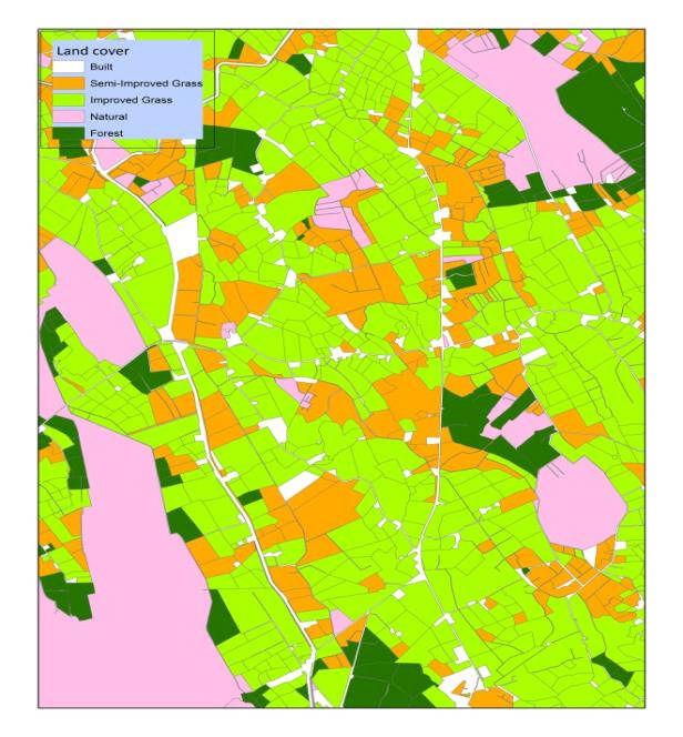
8 Unclosed areas What does landcover mean in these areas? How best to record extent and change? Classifications haven't been finalised- but will be guided b Helm and Eagle Internationall, Fossit locall and at all times with practicallit in mind.


9
10 Segmentation Essentiall the segmentation algorithm examines how like its neighbours a pixel is- if pixels are alike the are grouped into objects. We can use colour of texture or the shape of the object to help us segment an image- most popular software for soing this is e-cognition Its ver simalr to the human interpreation approach of mapping photomorphic regions and has been developed out of machine vision reserach
11 Texture Is a formal measurement of variation in tone. It s a statistical measure based on a fixed sample known as a kernel In its simplest form it could be that ever pixel is replaced with a value represents the standard deviation of the pixels around it
12 These segments become objects WE can then xclassif the object suing an of the classifcation we have looked at Unsupervised Supervised Rule based or descsion tree We can also include non-spectral data: eg the size of the object or its shape, the variation of pixels within an object (texture)

13
14
15 Scale:15 Color:0.2
16 Scale:15 Color:0.35
17 Scale:50 Color:0.2

18 Scale:15 Color:0.5
19 2.2 OBIA Strengths Partitioning an image into objects is akin to the wa humans conceptuall organize the landscape to comprehend it. Using image-objects as basic units reduces computational classifier and at the sametime enables the user to take advantage of more complex techniques (e.g. non-parametric). Image-objects exhibit useful features that single pixels lack. Image-objects can be more readil integrated in vector GIS. 2.3 OBIA Weaknesses There are numerous challenges involved in processing ver large datasets. Even if OBIA is more efficient than pixel-based approaches, segmenting a multispectral image of several tens of mega-pixels is a formidable task Segmentation is an ill-posed problem, in the sense it has no unique solution, There exists a poor understanding of scale and hierarchical relations among objects derived at different resolutions. Do segments at coarse resolutions reall emerge or evolve from the ones at finer resolutions? Should boundaries perfectl overlap (coincide) through scale? Operationall it s ver appealing, but what is the ecological basis for this?

20 Segmenation in ARcMAp
21 Image segmentation The image segmentation is based on the Mean Shift approach. The technique uses a moving window that calculates an average pixel value to determine which pixels should be included in each segment. As the window moves over the image, it iterativel recomputes the value to make sure that each segment is suitable. The result is a grouping of image pixels into a segment characterized b an average color
22 Compute Segment Attributes, supports ingest and export of segmented rasters both from and to third-part applications. This tool ingests a segmented image, a training site file, and an optional second raster to compute the attributes of each segment and output this information as an index raster file with associated attribute table.
23 The Classif Raster tool performs an image classification as specified b the Esri classifier definition file. Inputs to the tool include the image to be classified, the optional segmented raster (such as another raster dataset or a laer, such as a DEM), and a classifier definition file to generate the classified raster dataset. Note that the Classif Raster tool contains all the supported classifiers. The proper classifier is utilized depending on the properties and information contained in the classifier definition file. So the classifier definition file generated b the Train ISO Cluster Classifier, Train Maximum Likelihood Classifier, or Train Support Vector Machine Classifier will activate the corresponding classifier when ou run Classif Raster
24 Rule or Decision based classification Simplest wa to bring other elements into our classification is to constrain the output based on some other dataset.
25 Descsion tree approach Classifies an image based on rules or thresholds of pixels values Its akin to supervised classification but uses a non-parametric techniques to work backwards from the final classes to the orginal image based on brnahed es/no descesions Simplest form of decision tree is a series of threholds
26
27 In a bottom-up approach a binar tree is constructed using the training set. Using some distance measure, such as Mahalanobis-distance, pair-wise distances between a priori defined classes are computed and in each step the two classes with the smaller distance are merged to form a new group. The mean vector and the covariance matrix for each group are computed from the training samples of classes in that group, and the process is repeated until one is left with one group at the root. In a tree constructed this wa, the more obvious discriminations are done first, near the root, and more subtle ones at later stages of the tree. In top-down approaches, the design of a DTC reduces to the following three tasks: 1) The selection of a node splitting rule. 2) The decision as to which nodes are terminal. 3) The assignment of each terminal node to a class label. Of the above three tasks, the class assignment problem is b far the easiest. Basicall, to minimize the misclassification rate, terminal nodes are assigned to the classes which have the highest probabilities. These probabilities are usuall estimated b the ratio of samples from each class at that specific terminal node to the total number of samples at that specific terminal node. ftp://piekraste.daba.lv/pub/grafika/atteelu_analiize/multispec/publications/smc91.pdf

28 Setting up project inarcmap Open blank map Click WINDOWS Click Catalogue Click on the Connect to Folder Button Add our Thumb Drive for the list of drives


29 Right Click on the file tree on the Thumb Drive folderclick New Click Folder Create newfolder Right click on newfolder and create new file geodatabase- call it mnameproject.gdb So now save all our work into this and ou wont lose anthing

30 Start b adding our Image to the Geodirector Ricght Click on mnameproject.gdb then select Import Raster Datasets.. Make our image the Input raster and click OK our Image is now in our geodatabase Lastl Save (File->Save as..) the Map document to the folder on our Thumb Drive as mproject.mxd

31 SAVE all ou outputs and classification into mnameproject.gdb
32 A Simple Users Guide to selecting the right data Good for Continental Scale analsis Landsat 8 Level 2a MODIS Spot 4/5 Spot 6/7 PS Sentinel 2 LISS Eo-1 WorldView 2/ GeoEe IKONOS Rapid Ee Good for National Scale Good for count area coverage Good for seeing farm scale detail Good for seeing Subfield scale detail Good for Historical Change analsis Good for real time change detection Good for Broad vegetation classes Good for distinguishing habitats Good for species/genus level distinction Read to Use Free Needs atmospheric Correction
Dirty REMOTE SENSING : OBIA, Field work and GPS
 Dirty REMOTE SENSING : OBIA, Field work and GPS Stuart Green Teagasc Spatial Analysis Group Stuart.green@teagasc.ie Web for the Week: http://electronics.howstuffworks.com/gps.htm http://www.cstars.ucdavis.edu/classes/ers186-w03/lecture17/lecture17.ppt
Classifying. Stuart Green Earthobservation.wordpress.com MERMS 12 - L4
 Classifying Stuart Green Earthobservation.wordpress.com Stuart.Green@Teagasc.ie MERMS 12 - L4 Classifying Replacing the digital numbers in each pixel (that tell us the average spectral properties of everything
DIGITAL IMAGE ANALYSIS. Image Classification: Object-based Classification
 DIGITAL IMAGE ANALYSIS Image Classification: Object-based Classification Image classification Quantitative analysis used to automate the identification of features Spectral pattern recognition Unsupervised
Data: a collection of numbers or facts that require further processing before they are meaningful
 Digital Image Classification Data vs. Information Data: a collection of numbers or facts that require further processing before they are meaningful Information: Derived knowledge from raw data. Something
Figure 1: Workflow of object-based classification
 Technical Specifications Object Analyst Object Analyst is an add-on package for Geomatica that provides tools for segmentation, classification, and feature extraction. Object Analyst includes an all-in-one
Classification. Vladimir Curic. Centre for Image Analysis Swedish University of Agricultural Sciences Uppsala University
 Classification Vladimir Curic Centre for Image Analysis Swedish University of Agricultural Sciences Uppsala University Outline An overview on classification Basics of classification How to choose appropriate
ArcGIS Pro: Image Segmentation, Classification, and Machine Learning. Jeff Liedtke and Han Hu
 ArcGIS Pro: Image Segmentation, Classification, and Machine Learning Jeff Liedtke and Han Hu Overview of Image Classification in ArcGIS Pro Overview of the classification workflow Classification tools
Image Classification. RS Image Classification. Present by: Dr.Weerakaset Suanpaga
 Image Classification Present by: Dr.Weerakaset Suanpaga D.Eng(RS&GIS) 6.1 Concept of Classification Objectives of Classification Advantages of Multi-Spectral data for Classification Variation of Multi-Spectra
CHAPTER 5 OBJECT ORIENTED IMAGE ANALYSIS
 85 CHAPTER 5 OBJECT ORIENTED IMAGE ANALYSIS 5.1 GENERAL Urban feature mapping is one of the important component for the planning, managing and monitoring the rapid urbanized growth. The present conventional
COMBINING HIGH SPATIAL RESOLUTION OPTICAL AND LIDAR DATA FOR OBJECT-BASED IMAGE CLASSIFICATION
 COMBINING HIGH SPATIAL RESOLUTION OPTICAL AND LIDAR DATA FOR OBJECT-BASED IMAGE CLASSIFICATION Ruonan Li 1, Tianyi Zhang 1, Ruozheng Geng 1, Leiguang Wang 2, * 1 School of Forestry, Southwest Forestry
Digital Image Classification Geography 4354 Remote Sensing
 Digital Image Classification Geography 4354 Remote Sensing Lab 11 Dr. James Campbell December 10, 2001 Group #4 Mark Dougherty Paul Bartholomew Akisha Williams Dave Trible Seth McCoy Table of Contents:
ENVI ANALYTICS ANSWERS YOU CAN TRUST
 ENVI ANALYTICS ANSWERS YOU CAN TRUST HarrisGeospatial.com Since its launch in 1991, ENVI has enabled users to leverage remotely sensed data to better understand our complex world. Over the years, Harris
Classification. Vladimir Curic. Centre for Image Analysis Swedish University of Agricultural Sciences Uppsala University
 Classification Vladimir Curic Centre for Image Analysis Swedish University of Agricultural Sciences Uppsala University Outline An overview on classification Basics of classification How to choose appropriate
Exelis Visual Information Solutions Capability Overview Presented to NetHope October 8, Brian Farr Academic & NGO Program Manager
 Exelis Visual Information Solutions Capability Overview Presented to NetHope October 8, 2013 Brian Farr Academic & NGO Program Manager Agenda Overview of ENVI Platform ENVI+IDL ENVI EX ENVI LiDAR Integration
Raster Classification with ArcGIS Desktop. Rebecca Richman Andy Shoemaker
 Raster Classification with ArcGIS Desktop Rebecca Richman Andy Shoemaker Raster Classification What is it? - Classifying imagery into different land use/ land cover classes based on the pixel values of
A Vector Agent-Based Unsupervised Image Classification for High Spatial Resolution Satellite Imagery
 A Vector Agent-Based Unsupervised Image Classification for High Spatial Resolution Satellite Imagery K. Borna 1, A. B. Moore 2, P. Sirguey 3 School of Surveying University of Otago PO Box 56, Dunedin,
Classify Multi-Spectral Data Classify Geologic Terrains on Venus Apply Multi-Variate Statistics
 Classify Multi-Spectral Data Classify Geologic Terrains on Venus Apply Multi-Variate Statistics Operations What Do I Need? Classify Merge Combine Cross Scan Score Warp Respace Cover Subscene Rotate Translators
Remote Sensing & Photogrammetry W4. Beata Hejmanowska Building C4, room 212, phone:
 Remote Sensing & Photogrammetry W4 Beata Hejmanowska Building C4, room 212, phone: +4812 617 22 72 605 061 510 galia@agh.edu.pl 1 General procedures in image classification Conventional multispectral classification
Using Imagery for Intelligence Analysis
 2013 Esri International User Conference July 8 12, 2013 San Diego, California Technical Workshop Using Imagery for Intelligence Analysis Renee Bernstein Natalie Campos Esri UC2013. Technical Workshop.
Lab 9. Julia Janicki. Introduction
 Lab 9 Julia Janicki Introduction My goal for this project is to map a general land cover in the area of Alexandria in Egypt using supervised classification, specifically the Maximum Likelihood and Support
Exelis Visual Information Software Solutions for TERRAIN ANALYSIS. Defense & Intelligence SOLUTIONS GUIDE.
 Exelis Visual Information for TERRAIN ANALYSIS Defense & Intelligence SOLUTIONS GUIDE www.exelisvis.com MISSION SUCCESS The U.S. Armed Forces has long acknowledged the connection between battlefield terrain
Lab 5: Image Analysis with ArcGIS 10 Unsupervised Classification
 Lab 5: Image Analysis with ArcGIS 10 Unsupervised Classification Peter E. Price TerraView 2010 Peter E. Price All rights reserved Revised 03/2011 Revised for Geob 373 by BK Feb 28, 2017. V3 The information
Lecture 11: Classification
 Lecture 11: Classification 1 2009-04-28 Patrik Malm Centre for Image Analysis Swedish University of Agricultural Sciences Uppsala University 2 Reading instructions Chapters for this lecture 12.1 12.2 in
(Refer Slide Time: 0:51)
") Introduction to Remote Sensing Dr. Arun K Saraf Department of Earth Sciences Indian Institute of Technology Roorkee Lecture 16 Image Classification Techniques Hello everyone welcome to 16th lecture in
Introduction to Remote Sensing Dr. Arun K Saraf Department of Earth Sciences Indian Institute of Technology Roorkee Lecture 16 Image Classification Techniques Hello everyone welcome to 16th lecture in
IMAGINE Objective. The Future of Feature Extraction, Update & Change Mapping
 IMAGINE ive The Future of Feature Extraction, Update & Change Mapping IMAGINE ive provides object based multi-scale image classification and feature extraction capabilities to reliably build and maintain
Manual for Satellite Data Analysis. ecognition Developer
 - Manual for Satellite Data Analysis ecognition Developer PNGFA. December 2013 Table of Contents Chapter 1. Introduction... 2 Chapter 2. Characteristics of Spectrums... 5 Chapter 3. Differences between
Glacier Mapping and Monitoring
 Glacier Mapping and Monitoring Exercises Tobias Bolch Universität Zürich TU Dresden tobias.bolch@geo.uzh.ch Exercise 1: Visualizing multi-spectral images with Erdas Imagine 2011 a) View raster data: Open
Introduction to digital image classification
 Introduction to digital image classification Dr. Norman Kerle, Wan Bakx MSc a.o. INTERNATIONAL INSTITUTE FOR GEO-INFORMATION SCIENCE AND EARTH OBSERVATION Purpose of lecture Main lecture topics Review
Image Analysis Lecture Segmentation. Idar Dyrdal
 Image Analysis Lecture 9.1 - Segmentation Idar Dyrdal Segmentation Image segmentation is the process of partitioning a digital image into multiple parts The goal is to divide the image into meaningful
ENVI THE PREMIER SOFTWARE FOR EXTRACTING INFORMATION FROM GEOSPATIAL DATA
 ENVI THE PREMIER SOFTWARE FOR EXTRACTING INFORMATION FROM GEOSPATIAL DATA HarrisGeospatial.com BENEFITS Use one solution to work with all your data types Access a complete suite of analysis tools Customize
Pond Distance and Habitat for use in Wildlife Modeling
 Pond Distance and Habitat for use in Wildlife Modeling These instructions enable you to aggregate layers within a study area, calculate new fields, and create new data out of existing data, for use in
APPLICATION OF SOFTMAX REGRESSION AND ITS VALIDATION FOR SPECTRAL-BASED LAND COVER MAPPING
 APPLICATION OF SOFTMAX REGRESSION AND ITS VALIDATION FOR SPECTRAL-BASED LAND COVER MAPPING J. Wolfe a, X. Jin a, T. Bahr b, N. Holzer b, * a Harris Corporation, Broomfield, Colorado, U.S.A. (jwolfe05,
ELEC Dr Reji Mathew Electrical Engineering UNSW
 ELEC 4622 Dr Reji Mathew Electrical Engineering UNSW Review of Motion Modelling and Estimation Introduction to Motion Modelling & Estimation Forward Motion Backward Motion Block Motion Estimation Motion
Lesson 8 : How to Create a Distance from a Water Layer
 Created By: Lane Carter Advisor: Paul Evangelista Date: July 2011 Software: ArcGIS 10 Lesson 8 : How to Create a Distance from a Water Layer Background This tutorial will cover the basic processes involved
ENVI. Get the Information You Need from Imagery.
 Visual Information Solutions ENVI. Get the Information You Need from Imagery. ENVI is the premier software solution to quickly, easily, and accurately extract information from geospatial imagery. Easy
Remote Sensing Introduction to the course
 Remote Sensing Introduction to the course Remote Sensing (Prof. L. Biagi) Exploitation of remotely assessed data for information retrieval Data: Digital images of the Earth, obtained by sensors recording
Imagery and Raster Data in ArcGIS. Abhilash and Abhijit
 Imagery and Raster Data in ArcGIS Abhilash and Abhijit Agenda Imagery in ArcGIS Mosaic datasets Raster processing ArcGIS is a Comprehensive Imagery System Integrating All Types, Sources, and Sensor Models
LORI COLLINS, RESEARCH ASSOCIATE PROFESSOR CONTRIBUTIONS BY: RICHARD MCKENZIE AND GARRETT SPEED, DHHC USF L IBRARIES
 LORI COLLINS, RESEARCH ASSOCIATE PROFESSOR CONTRIBUTIONS BY: RICHARD MCKENZIE AND GARRETT SPEED, DHHC USF L IBRARIES AERIAL AND TERRESTRIAL SURVEY WORKFLOWS Workflow from project planning applications
Aerial photography: Principles. Visual interpretation of aerial imagery
 Aerial photography: Principles Visual interpretation of aerial imagery Overview Introduction Benefits of aerial imagery Image interpretation Elements Tasks Strategies Keys Accuracy assessment Benefits
Masking Lidar Cliff-Edge Artifacts
 Masking Lidar Cliff-Edge Artifacts Methods 6/12/2014 Authors: Abigail Schaaf is a Remote Sensing Specialist at RedCastle Resources, Inc., working on site at the Remote Sensing Applications Center in Salt
AN IMPROVED K-MEANS CLUSTERING ALGORITHM FOR IMAGE SEGMENTATION
 AN IMPROVED K-MEANS CLUSTERING ALGORITHM FOR IMAGE SEGMENTATION WILLIAM ROBSON SCHWARTZ University of Maryland, Department of Computer Science College Park, MD, USA, 20742-327, schwartz@cs.umd.edu RICARDO
Unsupervised Learning
 Outline Unsupervised Learning Basic concepts K-means algorithm Representation of clusters Hierarchical clustering Distance functions Which clustering algorithm to use? NN Supervised learning vs. unsupervised
Geographical Information Systems Institute. Center for Geographic Analysis, Harvard University. LAB EXERCISE 1: Basic Mapping in ArcMap
 Harvard University Introduction to ArcMap Geographical Information Systems Institute Center for Geographic Analysis, Harvard University LAB EXERCISE 1: Basic Mapping in ArcMap Individual files (lab instructions,
INF 4300 Classification III Anne Solberg The agenda today:
 INF 4300 Classification III Anne Solberg 28.10.15 The agenda today: More on estimating classifier accuracy Curse of dimensionality and simple feature selection knn-classification K-means clustering 28.10.15
Automatic Segmentation of Semantic Classes in Raster Map Images
 Automatic Segmentation of Semantic Classes in Raster Map Images Thomas C. Henderson, Trevor Linton, Sergey Potupchik and Andrei Ostanin School of Computing, University of Utah, Salt Lake City, UT 84112
Outline of Presentation. Introduction to Overwatch Geospatial Software Feature Analyst and LIDAR Analyst Software
 Outline of Presentation Automated Feature Extraction from Terrestrial and Airborne LIDAR Presented By: Stuart Blundell Overwatch Geospatial - VLS Ops Co-Author: David W. Opitz Overwatch Geospatial - VLS
Lidar and GIS: Applications and Examples. Dan Hedges Clayton Crawford
 Lidar and GIS: Applications and Examples Dan Hedges Clayton Crawford Outline Data structures, tools, and workflows Assessing lidar point coverage and sample density Creating raster DEMs and DSMs Data area
AN INTEGRATED APPROACH TO AGRICULTURAL CROP CLASSIFICATION USING SPOT5 HRV IMAGES
 AN INTEGRATED APPROACH TO AGRICULTURAL CROP CLASSIFICATION USING SPOT5 HRV IMAGES Chang Yi 1 1,2,*, Yaozhong Pan 1, 2, Jinshui Zhang 1, 2 College of Resources Science and Technology, Beijing Normal University,
Georeferencing Imagery in ArcGIS 10.3.x
 Georeferencing Imagery in ArcGIS 10.3.x Georeferencing is the process of aligning imagery (maps, air photos, etc.) with spatial data such as point, lines or polygons (for example, roads and water bodies).
Supervised vs unsupervised clustering
 Classification Supervised vs unsupervised clustering Cluster analysis: Classes are not known a- priori. Classification: Classes are defined a-priori Sometimes called supervised clustering Extract useful
Introduction to GIS & Mapping: ArcGIS Desktop
 Introduction to GIS & Mapping: ArcGIS Desktop Your task in this exercise is to determine the best place to build a mixed use facility in Hudson County, NJ. In order to revitalize the community and take
Welcome to NR402 GIS Applications in Natural Resources. This course consists of 9 lessons, including Power point presentations, demonstrations,
 Welcome to NR402 GIS Applications in Natural Resources. This course consists of 9 lessons, including Power point presentations, demonstrations, readings, and hands on GIS lab exercises. Following the last
Crop Counting and Metrics Tutorial
 Crop Counting and Metrics Tutorial The ENVI Crop Science platform contains remote sensing analytic tools for precision agriculture and agronomy. In this tutorial you will go through a typical workflow
GIS Data Collection. This chapter reviews the main methods of GIS data capture and transfer and introduces key practical management issues.
 9 GIS Data Collection OVERVIEW This chapter reviews the main methods of GIS data capture and transfer and introduces key practical management issues. It distinguishes between primary (direct measurement)
Submerged Aquatic Vegetation Mapping using Object-Based Image Analysis with Lidar and RGB Imagery
 Submerged Aquatic Vegetation Mapping using Object-Based Image Analysis with Lidar and RGB Imagery Victoria Price Version 1, April 16 2015 Submerged Aquatic Vegetation Mapping using Object-Based Image Analysis
Key Terms. Attribute join Target table Join table Spatial join
 Key Terms Attribute join Target table Join table Spatial join Lect 10A Building Geodatabase Create a new file geodatabase Map x,y data Convert shape files to geodatabase feature classes Spatial Data Formats
ORGANIZATION AND REPRESENTATION OF OBJECTS IN MULTI-SOURCE REMOTE SENSING IMAGE CLASSIFICATION
 ORGANIZATION AND REPRESENTATION OF OBJECTS IN MULTI-SOURCE REMOTE SENSING IMAGE CLASSIFICATION Guifeng Zhang, Zhaocong Wu, lina Yi School of remote sensing and information engineering, Wuhan University,
Files Used in This Tutorial. Background. Feature Extraction with Example-Based Classification Tutorial
 Feature Extraction with Example-Based Classification Tutorial In this tutorial, you will use Feature Extraction to extract rooftops from a multispectral QuickBird scene of a residential area in Boulder,
Image Segmentation. Srikumar Ramalingam School of Computing University of Utah. Slides borrowed from Ross Whitaker
 Image Segmentation Srikumar Ramalingam School of Computing University of Utah Slides borrowed from Ross Whitaker Segmentation Semantic Segmentation Indoor layout estimation What is Segmentation? Partitioning
By Colin Childs, ESRI Education Services. Catalog
 s resolve many traditional raster management issues By Colin Childs, ESRI Education Services Source images ArcGIS 10 introduces Catalog Mosaicked images Sources, mosaic methods, and functions are used
INCREASING CLASSIFICATION QUALITY BY USING FUZZY LOGIC
 JOURNAL OF APPLIED ENGINEERING SCIENCES VOL. 1(14), issue 4_2011 ISSN 2247-3769 ISSN-L 2247-3769 (Print) / e-issn:2284-7197 INCREASING CLASSIFICATION QUALITY BY USING FUZZY LOGIC DROJ Gabriela, University
The Feature Analyst Extension for ERDAS IMAGINE
 The Feature Analyst Extension for ERDAS IMAGINE Automated Feature Extraction Software for GIS Database Maintenance We put the information in GIS SM A Visual Learning Systems, Inc. White Paper September
Classification (or thematic) accuracy assessment. Lecture 8 March 11, 2005
 accuracy assessment. Lecture 8 March 11, 2005") Classification (or thematic) accuracy assessment Lecture 8 March 11, 2005 Why and how Remote sensing-derived thematic information are becoming increasingly important. Unfortunately, they contain errors.
Classification (or thematic) accuracy assessment Lecture 8 March 11, 2005 Why and how Remote sensing-derived thematic information are becoming increasingly important. Unfortunately, they contain errors.
ArcGIS for Server Imagery Update. Cody A. Benkelman Technical Product Manager, Imagery
 ArcGIS for Server Imagery Update Cody A. Benkelman Technical Product Manager, Imagery Outline Mosaic dataset Management and dissemination of imagery - Dynamic image services, Tiled Cache Visualization
Multi-resolution Segmentation and Shape Analysis for Remote Sensing Image Classification
 Multi-resolution Segmentation and Shape Analysis for Remote Sensing Image Classification Selim Aksoy and H. Gökhan Akçay Bilkent University Department of Computer Engineering Bilkent, 06800, Ankara, Turkey
Unsupervised learning in Vision
 Chapter 7 Unsupervised learning in Vision The fields of Computer Vision and Machine Learning complement each other in a very natural way: the aim of the former is to extract useful information from visual
Spectral Classification
 Spectral Classification Spectral Classification Supervised versus Unsupervised Classification n Unsupervised Classes are determined by the computer. Also referred to as clustering n Supervised Classes
ECG782: Multidimensional Digital Signal Processing
 ECG782: Multidimensional Digital Signal Processing Object Recognition http://www.ee.unlv.edu/~b1morris/ecg782/ 2 Outline Knowledge Representation Statistical Pattern Recognition Neural Networks Boosting
Lecture 06. Raster and Vector Data Models. Part (1) Common Data Models. Raster. Vector. Points. Points. ( x,y ) Area. Area Line.
 Common Data Models. Raster. Vector. Points. Points. ( x,y ) Area. Area Line.") Lecture 06 Raster and Vector Data Models Part (1) 1 Common Data Models Vector Raster Y Points Points ( x,y ) Line Area Line Area 2 X 1 3 Raster uses a grid cell structure Vector is more like a drawn map
Lecture 06 Raster and Vector Data Models Part (1) 1 Common Data Models Vector Raster Y Points Points ( x,y ) Line Area Line Area 2 X 1 3 Raster uses a grid cell structure Vector is more like a drawn map
TOPOGRAPHIC NORMALIZATION INTRODUCTION
 TOPOGRAPHIC NORMALIZATION INTRODUCTION Use of remotely sensed data from mountainous regions generally requires additional preprocessing, including corrections for relief displacement and solar illumination
FIELD-BASED CLASSIFICATION OF AGRICULTURAL CROPS USING MULTI-SCALE IMAGES
 FIELD-BASED CLASSIFICATION OF AGRICULTURAL CROPS USING MULTI-SCALE IMAGES A. OZDARICI a, M. TURKER b a Middle East Technical University (METU), Graduate School of Natural and Applied Sciences, Geodetic
HYPERSPECTRAL REMOTE SENSING
 HYPERSPECTRAL REMOTE SENSING By Samuel Rosario Overview The Electromagnetic Spectrum Radiation Types MSI vs HIS Sensors Applications Image Analysis Software Feature Extraction Information Extraction 1
Making Yield Contour Maps Using John Deere Data
 Making Yield Contour Maps Using John Deere Data Exporting the Yield Data Using JDOffice 1. Data Format On Hard Drive 2. Start program JD Office. a. From the PC Card menu on the left of the screen choose
Cluster Analysis: Agglomerate Hierarchical Clustering
 Cluster Analysis: Agglomerate Hierarchical Clustering Yonghee Lee Department of Statistics, The University of Seoul Oct 29, 2015 Contents 1 Cluster Analysis Introduction Distance matrix Agglomerative Hierarchical
Obtaining Submerged Aquatic Vegetation Coverage from Satellite Imagery and Confusion Matrix Analysis
 Obtaining Submerged Aquatic Vegetation Coverage from Satellite Imagery and Confusion Matrix Analysis Brian Madore April 7, 2015 This document shows the procedure for obtaining a submerged aquatic vegetation
Creating raster DEMs and DSMs from large lidar point collections. Summary. Coming up with a plan. Using the Point To Raster geoprocessing tool
 Page 1 of 5 Creating raster DEMs and DSMs from large lidar point collections ArcGIS 10 Summary Raster, or gridded, elevation models are one of the most common GIS data types. They can be used in many ways
Image Classification. Introduction to Photogrammetry and Remote Sensing (SGHG 1473) Dr. Muhammad Zulkarnain Abdul Rahman
 Dr. Muhammad Zulkarnain Abdul Rahman") Image Classification Introduction to Photogrammetry and Remote Sensing (SGHG 1473) Dr. Muhammad Zulkarnain Abdul Rahman Classification Multispectral classification may be performed using a variety of methods,
Image Classification Introduction to Photogrammetry and Remote Sensing (SGHG 1473) Dr. Muhammad Zulkarnain Abdul Rahman Classification Multispectral classification may be performed using a variety of methods,
Geomatics 89 (National Conference & Exhibition) May 2010
 May 2010") Evaluation of the Pixel Based and Object Based Classification Methods For Monitoring Of Agricultural Land Cover Case study: Biddinghuizen - The Netherlands Hossein Vahidi MSc Student of Geoinformatics
Evaluation of the Pixel Based and Object Based Classification Methods For Monitoring Of Agricultural Land Cover Case study: Biddinghuizen - The Netherlands Hossein Vahidi MSc Student of Geoinformatics
translatingnatureintoknowledge Dr Vanessa Lucieer
 Advancing quantitative techniques for the generation of acoustic variables to characterise seabed habitats. International workshop on seabed mapping methods and technology, Trondheim 17 th and 18 th October
Clustering. CS294 Practical Machine Learning Junming Yin 10/09/06
 Clustering CS294 Practical Machine Learning Junming Yin 10/09/06 Outline Introduction Unsupervised learning What is clustering? Application Dissimilarity (similarity) of objects Clustering algorithm K-means,
A Survey of Methods to Extract Buildings from High-Resolution Satellite Images Ryan Friese CS510
 A Survey of Methods to Extract Buildings from High-Resolution Satellite Images Ryan Friese CS510 There are many things in this world that are simply amazing. Some of these things are crafted by nature,
ii. From the Tools menu choose Multi-Extract
 Created By: Grant J. Firl Advisors: Paul Evangelista, Jim Graham Date: November 2010 Software: ArcGIS v9.2, TUGZip v3.5 Lesson 8: Mosaicking and Clipping Landsat Data The purpose of this tutorial is to
GIS-Generated Street Tree Inventory Pilot Study
 GIS-Generated Street Tree Inventory Pilot Study Prepared for: MSGIC Meeting Prepared by: Beth Schrayshuen, PE Marla Johnson, GISP 21 July 2017 Agenda 2 Purpose of Street Tree Inventory Pilot Study Evaluation
Presented at the FIG Congress 2018, May 6-11, 2018 in Istanbul, Turkey
 Presented at the FIG Congress 2018, May 6-11, 2018 in Istanbul, Turkey Evangelos MALTEZOS, Charalabos IOANNIDIS, Anastasios DOULAMIS and Nikolaos DOULAMIS Laboratory of Photogrammetry, School of Rural
2.2 Absolute Value Functions
 . Absolute Value Functions 7. Absolute Value Functions There are a few was to describe what is meant b the absolute value of a real number. You ma have been taught that is the distance from the real number
Region-based Segmentation and Object Detection
 Region-based Segmentation and Object Detection Stephen Gould Tianshi Gao Daphne Koller Presented at NIPS 2009 Discussion and Slides by Eric Wang April 23, 2010 Outline Introduction Model Overview Model
Experimentation on the use of Chromaticity Features, Local Binary Pattern and Discrete Cosine Transform in Colour Texture Analysis
 Experimentation on the use of Chromaticity Features, Local Binary Pattern and Discrete Cosine Transform in Colour Texture Analysis N.Padmapriya, Ovidiu Ghita, and Paul.F.Whelan Vision Systems Laboratory,
Segmentation of Images
 Segmentation of Images SEGMENTATION If an image has been preprocessed appropriately to remove noise and artifacts, segmentation is often the key step in interpreting the image. Image segmentation is a
Graph-theoretic Issues in Remote Sensing and Landscape Ecology
 EnviroInfo 2002 (Wien) Environmental Communication in the Information Society - Proceedings of the 16th Conference Graph-theoretic Issues in Remote Sensing and Landscape Ecology Joachim Steinwendner 1
An Approach To Classify The Object From The Satellite Image Using Image Analysis Tool
 IJIRST International Journal for Innovative Research in Science & Technology Volume 1 Issue 4 September 2014 ISSN(online) : 2349-6010 An Approach To Classify The Object From The Satellite Image Using Image
Understanding Clustering Supervising the unsupervised
 Understanding Clustering Supervising the unsupervised Janu Verma IBM T.J. Watson Research Center, New York http://jverma.github.io/ jverma@us.ibm.com @januverma Clustering Grouping together similar data
Edge Enhancement and Fine Feature Restoration of Segmented Objects using Pyramid Based Adaptive Filtering
 Edge Enhancement and Fine Feature Restoration of Segmented Objects using Pyramid Based Adaptive Filtering A. E. Grace and M. Spann School of Electronic and Electrical Engineering, The University of Birmingham,
A Graph Theoretic Approach to Image Database Retrieval
 A Graph Theoretic Approach to Image Database Retrieval Selim Aksoy and Robert M. Haralick Intelligent Systems Laboratory Department of Electrical Engineering University of Washington, Seattle, WA 98195-2500
Object-Based Classification & ecognition. Zutao Ouyang 11/17/2015
 Object-Based Classification & ecognition Zutao Ouyang 11/17/2015 What is Object-Based Classification The object based image analysis approach delineates segments of homogeneous image areas (i.e., objects)
Post-Classification Change Detection of High Resolution Satellite Images Using AdaBoost Classifier
 , pp.34-38 http://dx.doi.org/10.14257/astl.2015.117.08 Post-Classification Change Detection of High Resolution Satellite Images Using AdaBoost Classifier Dong-Min Woo 1 and Viet Dung Do 1 1 Department
Application of fuzzy set theory in image analysis. Nataša Sladoje Centre for Image Analysis
 Application of fuzzy set theory in image analysis Nataša Sladoje Centre for Image Analysis Our topics for today Crisp vs fuzzy Fuzzy sets and fuzzy membership functions Fuzzy set operators Approximate
Region-based Segmentation
 Region-based Segmentation Image Segmentation Group similar components (such as, pixels in an image, image frames in a video) to obtain a compact representation. Applications: Finding tumors, veins, etc.
Unsupervised Learning : Clustering
 Unsupervised Learning : Clustering Things to be Addressed Traditional Learning Models. Cluster Analysis K-means Clustering Algorithm Drawbacks of traditional clustering algorithms. Clustering as a complex
CROP MAPPING WITH SENTINEL-2 JULY 2017, SPAIN
 _p TRAINING KIT LAND01 CROP MAPPING WITH SENTINEL-2 JULY 2017, SPAIN Table of Contents 1 Introduction to RUS... 3 2 Crop mapping background... 3 3 Training... 3 3.1 Data used... 3 3.2 Software in RUS environment...
Geomatica II Course guide
 Course guide Geomatica Version 2017 SP4 2017 PCI Geomatics Enterprises, Inc. All rights reserved. COPYRIGHT NOTICE Software copyrighted by PCI Geomatics Enterprises, Inc., 90 Allstate Parkway, Suite 501