VicRoads - GIS Workflow Based Speed Sign Management System
|
|
|
- Britton Lawson
- 5 years ago
- Views:
Transcription
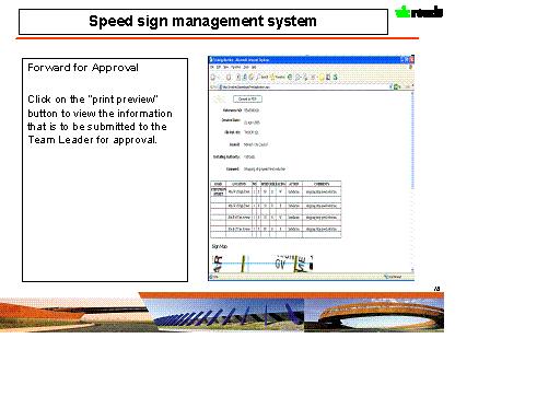
1 VicRoads - GIS Workflow Based Speed Sign Management System Domenic Gangi, Sandeep Badwal, Richard Zhou, Sameer Babbar Abstract VicRoads has developed a state-wide GIS speed sign management system that tracks the status of a request to install or replace a speed sign. The system allows the entry the proposed speed signs on the GIS map which are then forwarded for approval to the appropriate authority. If approved a Memorandum of Consent is automatically generated which textually describes the location of the signs in relation to the nearest side road, produces a schedule and map of those sign changes. This Consent is then forwarded via to the Council for installation with an automatically generated Notification of Completion (NOC) form to be returned upon installation. The system audits the status of any approved signs that have not yet been received within a month and then alerts the responsible officer to confirm status. The signs can be viewed at various stages; proposed, approved, installed, removed and not approved. Background and Overview VicRoads is the responsible state authority for managing the 22,320km of arterial road network which includes implementing road safety strategies and providing registration and licensing services in the state of Victoria, Australia. Speed is the biggest road safety challenge facing Victoria today. Over the last few years, VicRoads has heavily focussed on introducing speed enforcement using speed signs, speed zones etc. to reduce speeding on the road network. The new speed sign application has been designed to facilitate the process for assessing, approving, issuing, recording and auditing of speed sign information. VicRoads embarked a project in February 2004 to standardise the existing spreadsheets and word processor based practices of managing speed sign into an integrated workflow based management system. The key sponsorship for the project was provided by the road safety business area within VicRoads. From the beginning the project was envisaged as a multi user, multi region asset management enterprise system and single source for speed signs information in the state. Function The system utilises a GIS map to represent the location of speed signs on the road network at the various stages of the approval process; proposed, approved, installed, removed and not approved. Users of the system need to enter speed sign details into the system to process an application for a Memorandum of Consent (MOC) and forward it to their Team Leader for approval. If an application for an MOC is approved an MOC is automatically generated together with an accompanying Notification of Completion (NOC) form. The MOC will also include an automatically generated schedule of signs and a map of the proposed sign locations.
2 Once an MOC is approved and forwarded to the applicant either by or hardcopy, an NOC is to be returned to VicRoads within a month and entered into the system otherwise the application will trigger an requiring the NOC to be provided to VicRoads or confirmation provided that the signs have been installed as per the MOC. Details of the system functionality are attached in the appendix below. Technology An internal customised build option was preferred primarily because of heavy VicRoads specific functionality and the availability of good internet GIS skill sets within the organisation. The speed sign system makes use of ESRI technology, ArcIMS 9.0 with.net link, MapObject 2.0, integrated with MS Access as the database. This application utilises the Spatial Functionality web services created by VicRoads for common GIS functionality. The application comprises of four modules 1. Spatial functionality module 2. System functionality module 3. Application web Module 4. Work flow engine 5. Shape Edit module 6. Speed Signs placement Algorithm Spatial Functionality Module This module comprises of standard GIS functionality like Pan, Zoom, info, print, highlight etc. The print functionality is specifically enhanced by using PDF technology. VicRoads has created a series of web services which provide the above functionality.


3 System Functionality Module This module comprises of all the functionality to set the system framework. It includes an auto legend/table of Contents creator, which is a.net based application developed internally by VicRoads to create an enhanced Legend/TOC for ArcIMS based internet applications. This application takes ArcIMS AXL file as an input, allows the user to define the layers visibility, positioning etc. and then creates a legend/toc. The legend/toc can be expanded/collapsed or toggled and provide functionality like fast refresh, checkboxes to hide-show layers. It Stores the TOC/Legend configuration as a modifiable XML files which can be updated by the core application.


4 Legend/TOC: Application web Module/Core Module This module comprises of all the speed signs specific GIS functionality such as a list view of speed signs, search for an intersection, audit list etc. This functionality is created utilizing ArcIMS.Net connector and utilises Access as the database for managing the intersections information. It has a sophisticated reporting engine supporting both spatial and non-spatial queries, with a choice of output in either HTML or PDF formats. This provides the functionality to add, delete or update speed sign information and location. It provides the functionality to show images/photos as the background. This module also provides a front end to the workflow engine.

5 Work Flow Engine The work flow engine is designed for business rule changes. The speed sign application follows a lifecycle approach for speed signs, in which a number of activities can be performed on a speed sign. This module comprises the sequence definition of workflow activities. For a particular sign category, a flow id is defined based on the different steps that can be created regarding approval, delegation and policy. The flow steps and relative activities are defined in the database. Once the business rule(work process of speed sign application) changes, there s no need to change the source code of the system, the only requirement is to redefine the flow steps and relative activities in the database, the system will follow the new process to handle the speed sign applications.
6 Shape Edit Module This module comprises of the creating, deleting, updating speed sign spatial information on the web using ArcIMS and Mapobjects. This module provides a sophisticated locking mechanism built into the application, which allows the user to edit or add a speed sign without locking the shape file for all the users. Speed Signs Placement Algorithm The system utilises a complex algorithm for the placement of speed signs. The speed sign is defined in terms of location by the four elements. Road name on which the sign is to be referenced against
7 Side of the road the sign is on Nearest intersection of roads, roads start or road end Distance from the nearest intersection of roads, road start or road end Direction of the sign and the direction of the traffic It s a complicated and time consuming exercise for the users to enter all this information manually and accurately. There was a tendency for the data to become inconsistent because of wrong names etc. The users of the system were also not professional GIS operators and would need to be trainined to understand functionalities like snap, buffer etc. A one click algorithm has been developed to decrease the complexity of these operations. The user only needs to provide the distance from the nearest intersection etc. and click on the map. The system automatically calculates the other parameters like road name, direction etc. and show these to the user. Blank values before click User click on the map

8 Filled values after the click Software architecture Software Architecture Client ArcIMS Htmlviewer Web Client Application Sever Servlet Connector IIS ArcIMS App Server ArcIMS Spatial Server Signs Management System ArcIMS.NET link PDF Spatial Data Management Web Service Spatial Data Editor(MO ) Database System components ArcIMS components Signs Spatial Database(Shape Format) Signs Attributes Database(MDB) Developed components
9 The application is based on multitiered architecture and is developed using Microsoft.Net technology. Typically the user requests information over the intranet server using a browser. The server then processes the request, interacts with the database and sends the information back to the client viewer. Client Side components The applications client is based on ArcIMS HTML viewer. The standard functionality of the HTML viewer was enhanced by using webservcies to provide the application specific functionality. The client also used the VicRoads in-built tool for advance legend/toc. Server Side Components The client makes a request to the signs management system, dll s written in Microsoft.net. The system interacts with the database and retrieves the parameters required for the request. Based on these parameters an ArcIMS ArcXML request is created by the system and sent to the ArcIMS server using the ESRI ArcIMS.net Link. The System then handles the ArcXML response based on information returned from ArcIMS and appropriate client response is created. The spatial data management utility which is a wrapper dll built around ESRI mapobjects product is used to manage edits to the underlying shape file. The wrapper dll is written in Microsoft.net technology and also supports advance request management functionality so that the shape file doesn t get locked during editing. After the edits have been confirmed a request is sent to the ArcIMS via the system to refresh the map. The map is refreshed and the final map is shown to user with the changes, without the need to restart the ArcIMS services. Currently the system doesn t support simultaneous edits. Database components The database component consists of ESRI shapefiles and signs attribute MS Access database. The database is specifically designed to provide fast zoom/pan functionality for the speed signs application. The MS Access database stores all business information of the system, while the shape files only store the rendering information. Since various databases are used, an extra mechanism is developed to guarantee the data consistency between Access database and DBF database. Summary and future works Speed Signs management system was successfully rolled out in VicRoads in March The application team learnt many invaluable lessons during the system development specifically around webservices and component software development. The underlying architecture used in the speed sign application has also been adopted for some of the VicRoads internet application, using the same mechanism to edit data on the web. Continuous work is being carried out on improving the speed of the system. The team is also exploring the opportunities to allow multiple edits on the shapefile. Acknowledgements Many a thanks to GIS spatial services team in VicRoads with special mention to Richard Zhou,Qinglin Song and Sameer Babbar for their enormous support.
10 Appendix Details of the system functionality are including in the appendix Speed Sign System Functionaltiy : References 1- Author Information Domenic Gangi, Team Leader Data Management, VicRoads. 60 Denmark Street, Kew, Victoria 3101, Australia. Phone:+(03) ,domenic.gangi@roads.vic.gov.au Sandeep Badwal, Team Leader Functional (RoadsOne), VicRoads, 3 Prospect Hill Road, Camberwell, Victoria 3124, Australia. Phone:+(03) sandeep.badwal@roads.vic.gov.au Richard Zhou, VicRoads. 60 Denmark Street, Kew, Victoria 3101, Australia. Phone:+(03) ,Richard.zhou@roads.vic.gov.au Sameer Babbar, Team Leader, Spatial Services, VicRoads. 60 Denmark Street, Kew, Victoria 3101, Australia. Phone:+(03) ,Sameer.babbar@roads.vic.gov.au

11 Appendix: Speed Sign System Functionaltiy Speed sign management system Functions Applications requesting consent to install or remove speed signs are displayed on a GIS map at the following stages of the process: Proposed Approved Installed Removed Not Approved 2

12

13

14
15
16
17
18

19
20

21
PLATE TECTONICS DATA VIEWER Developed by Claudia Owen and Eric Sproles
 PLATE TECTONICS DATA VIEWER Developed by Claudia Owen and Eric Sproles What is a Data Viewer? A data viewer is a program to view maps on the Internet that were generated by a Geographic Information System
SHARING GEOGRAPHIC INFORMATION ON THE INTERNET ICIMOD S METADATA/DATA SERVER SYSTEM USING ARCIMS
 SHARING GEOGRAPHIC INFORMATION ON THE INTERNET ICIMOD S METADATA/DATA SERVER SYSTEM USING ARCIMS Sushil Pandey* Birendra Bajracharya** *International Centre for Integrated Mountain Development (ICIMOD)
FAQ & Troubleshooting
 FAQ & Troubleshooting What is the most common issue users have when using the site? Pop-Up Blocker!!! Any link external to the viewer requires a new window to be opened in the browser. See My map or report
CityMap SDK: Assembling Web Services into a Batch Geocoding Application
 CityMap SDK: Assembling Web Services into a Batch Geocoding Application Avencia Incorporated James Querry City of Philadelphia Objectives 1. Why web services? 2. Which services were useful? 3. How can
Explore some of the new functionality in ArcMap 10
 Explore some of the new functionality in ArcMap 10 Scenario In this exercise, imagine you are a GIS analyst working for Old Dominion University. Construction will begin shortly on renovation of the new
Paragon Fundamentals. Workbook
 Paragon Fundamentals Workbook Welcome to the Paragon Fundamentals course. This hands-on introductory course is intended to provide REALTORS with the skills to use Paragon as their primary business tool.
Introduction to Autodesk MapGuide EnterpriseChapter1:
 Chapter 1 Introduction to Autodesk MapGuide EnterpriseChapter1: In this chapter, you review the high-level key components that comprise Autodesk MapGuide Enterprise. The Autodesk MapGuide Studio, an integral
DataCollect Administrative Tools Supporting DataCollect (CMDT 3900) Version 3.0.0
 Version 3.0.0") Administrator Manual DataCollect Administrative Tools Supporting DataCollect (CMDT 3900) Version 3.0.0 P/N 15V-090-00054-100 Revision A SKF is a registered trademark of the SKF Group. All other trademarks
Administrator Manual DataCollect Administrative Tools Supporting DataCollect (CMDT 3900) Version 3.0.0 P/N 15V-090-00054-100 Revision A SKF is a registered trademark of the SKF Group. All other trademarks
etendering PORTAL User Manual Product Version 7-0-4
 etendering PORTAL User Manual Product Version 7-0-4 Open Windows Software Pty Ltd ABN 22 605 191 375 635 Glenferrie Road, Hawthorn VIC 3122, Australia Phone: +61 3 9819 5088 Email: support@openwindows.com.au
Microsoft Developing SQL Databases
 1800 ULEARN (853 276) www.ddls.com.au Length 5 days Microsoft 20762 - Developing SQL Databases Price $4290.00 (inc GST) Version C Overview This five-day instructor-led course provides students with the
Moving Dynamic Segmentation to the Server: Linear Referencing for Web- Based Applications
 Moving Dynamic Segmentation to the Server: Linear Referencing for Web- Based Applications Paper 6.4.2 Graham Stickler and Rob Coupe Exor Corporation Contents Why move things to the database Oracle spatial
Tutorial 1. Extending ArcIMS Using ArcXML Rendering
 Extending ArcIMS Using ArcXML Rendering Tutorial 1 This is the first of three companion tutorials for Extending ArcIMS MapServices Using ArcXML, an article by Mark Ho that appeared in the January March
Visio for IT Professionals 1 & 2
 Visio for IT Professionals 1 & 2 Visio for IT Professionals 1 & 2 1. Contents BICSI APPROVED ADTP TRAINING CENTRE Contents 1. Welcome to Networks Centre Training Academy 2. Course Overview 3-4. Course
Cuyahoga County Addressing Notification System Cuyahoga County Department of Information Technology
 Page(s) 1 of 10 Administrative Standard Operating Procedure Cuyahoga County Addressing Notification System Cuyahoga County Department of Information Technology Document Revision History Date of Revision
Visio for Data Centre Professionals 1 & 2
 Visio for Data Centre Professionals 1 & 2 Visio for Data Centre Professionals 1 & 2 1. Contents BICSI APPROVED ADTP TRAINING CENTRE Contents 1. Welcome to Networks Centre Training Academy 2. Course Overview
Introduction to Autodesk MapGuide EnterpriseChapter1:
 Chapter 1 Introduction to Autodesk MapGuide EnterpriseChapter1: In this chapter, you review the high-level key components that make up Autodesk MapGuide Enterprise. The Autodesk MapGuide Studio, an integral
Getting Started With ArcIMS
 Getting Started With ArcIMS Copyright 2004 ESRI All Rights Reserved. Printed in the United States of America. The information contained in this document is the exclusive property of ESRI. This work is
Scanshare Sales Guide V1.2
 Scanshare Sales Guide V1.2 What is Scanshare? The document business critical data, currently locked in paper form The MFD the on ramp to an organisation s digital information workflow Scanshare the middleware/bridge
Commercial software from the ESRI company to create display and produce maps
 OCEANIDES USER MANUAL & DATABASE DESCRIPTION Contract No. Project Deliverable Document Title Document File Name Reference EVK2-CT-2002-00177 Database description and user manual User manual & database
Starting the QGIS Program. Exercise 1: Exploring QGIS
 Exercise 1: Exploring QGIS In this exercise you will learn how to open maps, manipulate layers, add spatial data, change symbols, and navigate within QGIS. You will also learn to repair broken data links.
Oracle Spatial A Unifying Framework at the Utah Department Of Transportation
 Oracle Spatial A Unifying Framework at the Utah Department Of Transportation Dan Paske Utah Department of Transportation Oracle DBA Jeff Saunders Farallon Geographics, Inc. Senior Geodatabase Developer
Juniata County, Pennsylvania
 GIS Parcel Viewer Web Mapping Application Functional Documentation June 21, 2017 Juniata County, Pennsylvania Presented by www.worldviewsolutions.com (804) 767-1870 (phone) (804) 545-0792 (fax) 115 South
Locating unknown connection services during reading routes
 1 Locating unknown connection services during reading routes Introduction Canal de Isabel II was founded in 1851 to provide water to Madrid (capital of Spain). Now it provides water to 5.5 million people
Trellis Real-Time Infrastructure Optimization Platform Release Notes
 VERTIV Trellis Real-Time Infrastructure Optimization Platform Release Notes VERSION 5.0.1.1, APRIL 13, 2018 Release Notes Section Outline 1 New Features Overview 2 General Features Overview 3 Notes and
Accessing OGC Services To access OGC WMS and WFS open the service in the directory that you want to consume, and click on either WMS or WFS.
 Using Web Services Web Services Overview This user guide contains instructions on how to consume a range of services through a range of both web based and desktop GIS applications. Web services are a live
USER GUIDE. Created by MyCRM Ltd. emap. Installation and Configuration
 USER GUIDE Created by MyCRM Ltd emap Installation and Configuration MyCRM Ltd 1/1/2014 2 About This Guide This guide is intended for CRM system administrators who wish to understand the installation, configuration
Supplier On-board Request
 w Supplier On-board Request Date: February 2018 Contents Heading 1... 2 Heading 2... Error! Bookmark not defined. Heading 3... Error! Bookmark not defined. Contents Introduction... 3 Request Settings...
Aquantify System Overview Version 2.7
 System Overview Version 2.7 Table of Contents 1. INTRODUCTION 1 2. TECHNICAL DETAILS AND ARCHITECTURE 1 3. USAGE SCENARIOS 2 4. FLEXIBLE AND CUSTOMISABLE CONFIGURATION 2 4.1 SAMPLE POINTS 2 4.2 PARAMETERS
Introduction to ArcGIS API for Flex. Bjorn Svensson Lloyd Heberlie
 Introduction to ArcGIS API for Flex Bjorn Svensson Lloyd Heberlie Agenda API Introduction Getting started API concepts and examples Getting more information API Introduction ArcGIS 10 A Complete System
Operations Dashboard for ArcGIS Monitoring GIS Operations. Michele Lundeen Esri
 Operations Dashboard for ArcGIS Monitoring GIS Operations Michele Lundeen Esri mlundeen@esri.com What is a dashboard? Conceptual term, can mean different things to different audiences Dashboards provide
Instructions for using Borg and Ide CONNECT. Referring Provider Portal. Version 3.5.
 Instructions for using Borg and Ide CONNECT Referring Provider Portal www.borgideconnect.com Version 3.5 Topic Table of Name Contents Description Getting Started...1 Home Page and Finding Patient Exams...2
Client Setup (.NET, Internet Explorer)
") Powered By: Version 2.0 Created December, 2008 .NET & Internet Explorer Setup Client Setup (.NET, Internet Explorer) The WebTMS application itself is a windows executable program. In order to run WebTMS,
Powered By: Version 2.0 Created December, 2008 .NET & Internet Explorer Setup Client Setup (.NET, Internet Explorer) The WebTMS application itself is a windows executable program. In order to run WebTMS,
Building Vector Layers
 Building Vector Layers in QGIS Introduction: Spatially referenced data can be separated into two categories, raster and vector data. This week, we focus on the building of vector features. Vector shapefiles
TMIS. Traffic Management Interface System
 Traffic Management Interface System Technical Overview General The main task of TMIS is to provide the TMC Operations and Management with an overview of the state of the traffic management system in real-time.
Level 2 Combining word processing, spreadsheet and database applications to present information (7266/ )
") Level 2 Combining word processing, spreadsheet and database applications to present information (7266/7267-029) e-quals Assignment guide for Candidates Assignment B www.cityandguilds.com/e-quals07 February
Level 2 Combining word processing, spreadsheet and database applications to present information (7266/7267-029) e-quals Assignment guide for Candidates Assignment B www.cityandguilds.com/e-quals07 February
ArcSDE architecture and connections
 ArcSDE architecture and connections Lesson overview ArcSDE system components Application Server Connections Direct Connect Geodatabase properties ArcSDE versions What is a version ArcIMS and versions 6-2
d-cyphamap an Internet delivered spatial decision support system
 d-cyphamap an Internet delivered spatial decision support system Matthew Lythe GIS Technical Architect d-cypha Limited ABSTRACT The provision of dynamic mapping and spatial analysis over the Internet poses
GIS Virtual Workshop: Geocoding
 This module will deal with the concept of geocoding of data. Geocoding is placing a data point which does not have a X, Y reference (no Latitude and Longitude) and automatically mapping it by knowing the
Salesforce Enterprise Edition Upgrade Guide
 Salesforce Enterprise Edition Upgrade Guide Salesforce, Spring 16 @salesforcedocs Last updated: February 11, 2016 Copyright 2000 2016 salesforce.com, inc. All rights reserved. Salesforce is a registered
Quick Guide to MapWindow GIS Desktop Application
 Quick Guide to MapWindow 1 Quick Guide to MapWindow GIS Desktop Application Version 2 January 2007 Adapted by Tom Croft. This is a summary user guide for commonly used tools and capabilities and does not
10 Minute Demonstration Script
 10 Minute Demonstration Script Table of Contents The Demo... 3 The Interface... 3 Demo Flow... 3 Capture and Indexing... 4 Searches... 6 Integration and Workflow... 8 2 P a g e The Demo Most demonstrations
NMCRIS Map Service Application Feature Editing
 NMCRIS Map Service Application Feature Editing Exercise goal: Users will edit the polygonal boundaries for activities and resources in the NMCRIS Map Service. Important: This exercise is a sample presentation
APPENDIX. Using Google Sites. After you read this appendix, you will be able to:
 APPENDIX B Using Google Sites Objectives After you read this appendix, you will be able to: 1. Create a New Site 2. Manage Your Sites 3. Collaborate on a Shared Site The following Hands-On Exercises will
Start IT (itq) Database software ( )
 Database software ( )") Start IT (itq) Database software (4249-002) Assignment guide for Candidates Assignment A QCA Ref: J/502/0169 www.cityandguilds.com May 2009 Version 3.0 About City & Guilds City & Guilds is the UK s leading
Start IT (itq) Database software (4249-002) Assignment guide for Candidates Assignment A QCA Ref: J/502/0169 www.cityandguilds.com May 2009 Version 3.0 About City & Guilds City & Guilds is the UK s leading
Chapter 1 : Getting Started with Integrity... Chapter 2 : Interface Layout... Chapter 3 : Navigation... Chapter 4 : Printing...
 .0 User s Manual Table of Contents Chapter : Getting Started with Integrity... Chapter : Interface Layout... Chapter : Navigation... Chapter : Printing... Chapter : Quick Search and Results Pane... Results
Step by Step How to Manual
 www.quintewestmaps.com Step by Step How to Manual Click on to accept the disclaimer and go to the web GIS Step by Step Web Based GIS Interface Layout of Web Based GIS Save your Favorite Map Views Link
Level 1 Using the Internet for finding and sending information (7266/ )
") Level 1 Using the Internet for finding and sending information (7266/7267-005) e-quals Assignment guide for Candidates Assignment B (This assignment can be used as evidence of achievement of 7574-107 Using
Level 1 Using the Internet for finding and sending information (7266/7267-005) e-quals Assignment guide for Candidates Assignment B (This assignment can be used as evidence of achievement of 7574-107 Using
Microsoft Developing Microsoft SharePoint Server 2013 Advanced Solutions
 1800 ULEARN (853 276) www.ddls.com.au Microsoft 20489 - Developing Microsoft SharePoint Server 2013 Advanced Solutions Length 5 days Price $4290.00 (inc GST) Version B Overview This course provides SharePoint
Egress Switch Desktop Client
 1 COMMERCIAL IN CONFIDENCE Egress Switch Desktop Client User guide Copyright 2017 Egress Software Technologies Ltd. All rights reserved. 2 COMMERCIAL IN CONFIDENCE Confidentiality Statement This document
REDI 5.0 User Manual
 REDI 5.0 User Manual OBJECTIVE: REDI (Regional Economic Development Information System) provides a quick, convenient and easy way of accessing the City of San Diego Business Incentive Zones (BIZ) information.
How to use the New St. Mary s County s Zoning Map Viewer
 How to use the New St. Mary s County s Zoning Map Viewer You must turn off any pop-up blocking in your web- browser for the tools to work effectively in this mapping application. The New Zoning Map Viewer
Biodiversity GIS Land Use Decision Support (LUDS) tool: A semantic webbased tool for environmental and biodiversity planning in South Africa
 tool: A semantic webbased tool for environmental and biodiversity planning in South Africa") Biodiversity GIS Land Use Decision Support (LUDS) tool: A semantic webbased tool for environmental and biodiversity planning in South Africa Martin Cocks and Richard Knight Biodiversity and Conservation
Biodiversity GIS Land Use Decision Support (LUDS) tool: A semantic webbased tool for environmental and biodiversity planning in South Africa Martin Cocks and Richard Knight Biodiversity and Conservation
TRIMS Web. Next Generation TRIMS TD T. Go.
 TRIMS Web Next Generation TRIMS Go. Overview The what: What is it? What are its benefits? The who: Who are its clients? Who developed it? The how: How is it architected? How is it deployed? The Application
VETtrak Data Insights User Guide. for VETtrak version
 VETtrak Data Insights User Guide for VETtrak version 4.4.8.2 Contents Data Insights User Guide... 2 What are Data Insights?... 2 Why is it called Data Insights?... 2 Why did we create this new feature?...
Building and Deploying Enterprise ArcGIS Server Solutions (Best Practices) Wittaker Mathot Developer Summit
 Wittaker Mathot Developer Summit") Building and Deploying Enterprise ArcGIS Server Solutions (Best Practices) Wittaker Mathot Developer Summit 2007 1 Presentation Goals See real world, Enterprise implementations of ArcGIS Server presented
Building and Deploying Enterprise ArcGIS Server Solutions (Best Practices) Wittaker Mathot Developer Summit 2007 1 Presentation Goals See real world, Enterprise implementations of ArcGIS Server presented
What Is the ArcIMS Tracking Server?
 What Is the ArcIMS Tracking Server? An ESRI White Paper May 2003 ESRI 380 New York St., Redlands, CA 92373-8100, USA TEL 909-793-2853 FAX 909-793-5953 E-MAIL info@esri.com WEB www.esri.com Copyright 2003
How to use the DuPage County Parcel Viewer Interactive Web Mapping Application.
 How to use the DuPage County Parcel Viewer Interactive Web Mapping Application. Parcel Viewer URL: URL: http://gis.dupageco.org/parcelviewer/ Initial View (And frequently asked questions) Parcel Search
e-quals Unit Syllabus
 e-quals Unit Syllabus Level 2 Designing and creating presentations 7266-026 www.cityandguilds.com/e-quals07 March 2007 Version 1.0 About City & Guilds City & Guilds is the UK s leading provider of vocational
Tutorial for Lane County Mapping Applications
 Tutorial for Lane County Mapping Applications Contents Overview... 2 Tools... 2 Navigation Tools... 3 Display Tools... 5 Information Tools... 6 Sharing Tools... 7 Common Tasks... 9 Identify or Show Data
What s New. New and Enhanced Features in NetSupport DNA v4. Welcome Dashboard. Auto Discovery. Platform Support
 What s New New and Enhanced Features in NetSupport DNA v4 Welcome to NetSupport DNA version 4, the fresh approach to IT Asset Management. With any new release, the focus is not only on introducing innovative
Guide to Mapping Website (Public) December 2016 GC_236594
 December 2016 GC_236594") Guide to Mapping Website (Public) December 2016 GC_236594 Table of Contents Guide to Mapping Website (Public)... 1 December 2016... 1 Quick Start... 3 Map Layers... 4 How do I?... 5 Draw on the Map...
Guide to Mapping Website (Public) December 2016 GC_236594 Table of Contents Guide to Mapping Website (Public)... 1 December 2016... 1 Quick Start... 3 Map Layers... 4 How do I?... 5 Draw on the Map...
Modern Requirements4TFS 2018 Release Notes
 Modern Requirements4TFS 2018 Release Notes Modern Requirements 3/7/2018 Table of Contents 1. INTRODUCTION... 3 2. SYSTEM REQUIREMENTS... 3 3. APPLICATION SETUP... 3 GENERAL... 4 1. FEATURES... 4 2. ENHANCEMENT...
Quark XML Author Adapter for FileNet 2.8 ReadMe
 Quark XML Author Adapter for FileNet 2.8 ReadMe Contents Quark XML Author Adapter for FileNet ReadMe...1 System requirements...2 Quark XML Author Adapter for FileNet installation procedure..4 Enabling.NET
2016 New Zealand Spatial Excellence Awards: Category: Award for Technical Excellence - Award Application
 Lessons learned from one of New Zealand s most challenging civil engineering projects: rebuilding the earthquake damaged pipes, roads, bridges and retaining walls in the city of Christchurch 2011-2016.
Adobe Document Cloud esign Services. for Salesforce Version 17 Installation and Customization Guide
 Adobe Document Cloud esign Services for Salesforce Version 17 Installation and Customization Guide 2015 Adobe Systems Incorporated. All rights reserved. Last Updated: August 28, 2015 Table of Contents
LRS Maintenance at Idaho Transportation Department
 LRS Maintenance at Idaho Transportation Department Phil Hardy LRS Product Manager Brian Emmen GIS Manager Idaho Transportation Dept. LRS History at ITD Mainframe-based attribute system (MACS) Functional
Spidertracks Website User Guide
 Version 7.1.0 4 May 2016 Spidertracks Website User Guide For using the Spidertracks Go website and additional information. 1 Table of Contents 1. Website Architecture 2. Create a User Account 3. Creating
Quark XML Author Adapter for FileNet 2.7 with Business Documents ReadMe
 Quark XML Author Adapter for FileNet 2.7 with Business Documents ReadMe Contents Quark XML Author 2015 ReadMe...1 System requirements...2 Quark XML Author Adapter for FileNet installation procedure..4
Installing ArcIMS 9.1 on Windows
 ArcGIS 9.1 Installing ArcIMS 9.1 on Windows Table Of Contents Introduction...1 Overview...2 What s included with ArcIMS 9.1?...2 ArcIMS components...2 ArcIMS Manager...3 ArcIMS Manager Applications...3
Map Functions August 3, 2015 Triangle Homes Group
 Map Functions August 3, 2015 Triangle Homes Group Preston Neighborhoods and Property Map The Map is an interactive web based using ArcGIS Online by ESRI ESRI is the world s largest Geographic Information
Level 1Using mobile IT devices (UMD )
") Level 1Using mobile IT devices (UMD 7574-110) ITQ (QCF) Assignment guide for Candidates Assignment A www.cityandguilds.com February 2010 Version 1.0 About City & Guilds City & Guilds is the UK s leading
Level 1Using mobile IT devices (UMD 7574-110) ITQ (QCF) Assignment guide for Candidates Assignment A www.cityandguilds.com February 2010 Version 1.0 About City & Guilds City & Guilds is the UK s leading
WEB BASED CAMPUS INFORMATION SYSTEM
 WEB BASED CAMPUS INFORMATION SYSTEM Arif Çağdaş Aydınoğlu 1, Tahsin Yomralıoğlu 2 Department of Geodesy & Photogrammetry Engineering, Karadeniz Technical Unıversity, Trabzon, TURKEY www.gislab.ktu.edu.tr
Best Practice. Spreadsheet Modelling Standards. Developed and maintained by the Spreadsheet Standards Review Board
 Version 6.1 Best Practice Spreadsheet Modelling Standards Developed and maintained by the Spreadsheet Standards Review Board BEST PRACTICE SPREADSHEET MODELLING STANDARDS - VERSION 6.1 This document is
User Manual for the delivery of a new national Natura 2000 database to the Commission. Version 1.1
 User Manual for the delivery of a new national Natura 2000 database to the Commission Version 1.1 The Natura 2000 network of protected sites consists of the sites classified under the Birds Directive first
TRAINING GUIDE. Lucity GIS. Web Administration
 TRAINING GUIDE Lucity GIS Web Administration Lucity GIS Web Administration Contents Portal Config and SSO... 2 Registering with Portal... 2 Behind the Scenes... 4 Resetting Portal Integration... 5 Single
MindManager Enterprise for Windows Release Notes
 MindManager Enterprise for Windows Release Notes February 11, 2016 Release version: 16.1.193 Mindjet Corporation Toll Free: 877-Mindjet 1160 Battery Street East San Francisco CA 94111 USA Phone: 415-229-4200
Overview of ArcGIS Online Applications. Champaign County
 Overview of ArcGIS Online Applications Champaign County Champaign County GIS Consortium Updated: April 2017 Table of Contents ArcGIS Online Application Overview... 3 Map Interface Symbology and Terminology...
Raster Serving with ArcGIS
 Raster Serving with ArcGIS Agenda Introduction to server technology Workflow considerations ESRI raster serving technology ArcGIS Server Basic (ArcSDE) ArcGIS Server Standard/Advanced Web Services ArcGIS
Compass INSPIRE Services. Compass INSPIRE Services. White Paper Compass Informatics Limited Block 8, Blackrock Business
 Compass INSPIRE Services White Paper 2010 Compass INSPIRE Services Compass Informatics Limited Block 8, Blackrock Business Park, Carysfort Avenue, Blackrock, County Dublin, Ireland Contact Us: +353 1 2104580
GWPC Directional Survey Upload Application Implementation Considerations
 GWPC Directional Survey Upload Application Implementation Considerations RBDMS Annual Training Conference, Lido Beach, Florida April 3, 2019 Jim Milne, Dan Jarvis, Scott Bland Presentation Outline Overview
itrail Convoy (Global) User s Manual
 User s Manual") itrail Convoy (Global) User s Manual 1 What s Inside 1. Wiring Harness 2. Antenna 3. itrail Convoy Base Device 4. Serial Number (Located on the box and device) 1 2 2 3 4 3 itrail Convoy Wiring Diagram
itrail Convoy (Global) User s Manual 1 What s Inside 1. Wiring Harness 2. Antenna 3. itrail Convoy Base Device 4. Serial Number (Located on the box and device) 1 2 2 3 4 3 itrail Convoy Wiring Diagram
DSL Target Marketing using ArcIMS. Authored By: Eric Pimpler and Eric Cabading
 DSL Target Marketing using ArcIMS Authored By: Eric Pimpler and Eric Cabading Abstract SBC Communications, Inc., is a global leader in telecommunications services, and provides a full range of voice, data,
ACTIVEDOCS OPUS INTEGRATION DATA SOURCE INTEGRATION AND APPLICATION INTEGRATION WITH EMPHASIS ON MICROSOFT SHAREPOINT AND MICROSOFT CRM
 DATA SOURCE INTEGRATION AND APPLICATION INTEGRATION WITH EMPHASIS ON MICROSOFT SHAREPOINT AND MICROSOFT CRM Prepared by: Audience: Nick Chivers VP European Operations ActiveDocs Evaluator Abstract: This
Oracle Spatial Pure Web Editing for Telco Outside Plant Engineering Planning. Eamon Walsh espatial Solutions
 Spatial SIG Oracle Spatial Pure Web Editing for Telco Outside Plant Engineering Planning Eamon Walsh espatial Solutions Speaker Eamon Walsh, CTO espatial Solutions. over 20 years experience in the IT industry,
GGR 375 QGIS Tutorial
 GGR 375 QGIS Tutorial With text taken from: Sherman, Gary E. Shuffling Quantum GIS into the Open Source GIS Stack. Free and Open Source Software for Geospatial (FOSS4G) Conference. 2007. Available online
Approval Workflow Release Notes
 Approval Workflow Release Notes Approval Workflow Release Notes Document: Approval Workflow - Release Notes.pdf Version: 3.20.B Printed: 11.4.2018 Spica International Pot k sejmiscu 33 1231 Ljubljana Slovenia
Ctrack Online User Guide
 Fleetstar Online A Guide to Winter Maintenance Reporting v1.1 Ctrack Online User Guide Title: Ctrack Online Quickstart Guide Date: 18/07/2013 Version: 1.0 Table of Contents 1. Ctrack Online Introduction...
Schedule 3 Background 3 What is ArchSite? 3 Introduction 3 ArchSite Viewer Options 4 Disclaimers 5 Creating a User Account 5 Working with the Public
 Introduction to ArchSite TABLE OF CONTENTS Schedule 3 Background 3 What is ArchSite? 3 Introduction 3 ArchSite Viewer Options 4 Disclaimers 5 Creating a User Account 5 Working with the Public View 6 Public
QualiWare Lifecycle Manager. Starter course
 QualiWare Lifecycle Manager Starter course Agenda Introduction: agenda, course objectives, presentation Overview About QualiWare Set-up and navigation How to draw diagrams How to describe diagrams and
What s New in Desktop 10.1
 What s New in Desktop 10.1 Damian Spangrud Esri Redlands Trip Down Memory Lane ArcGIS A Complete System for Geographic Information Cloud Web Online Mobile Enterprise Desktop Sharing Information sharing
Managing TxDOT Highway Improvement Projects in a Web-based GIS Environment
 Managing TxDOT Highway Improvement Projects in a Web-based GIS Environment Nicholas Koncz Cesar Quiroga Geospatial Information Systems for Symposium Houston, TX, March 17, 2008 Operations Group 1 Research
DEVELOPING MICROSOFT SHAREPOINT SERVER 2013 ADVANCED SOLUTIONS. Course: 20489A; Duration: 5 Days; Instructor-led
 CENTER OF KNOWLEDGE, PATH TO SUCCESS Website: DEVELOPING MICROSOFT SHAREPOINT SERVER 2013 ADVANCED SOLUTIONS Course: 20489A; Duration: 5 Days; Instructor-led WHAT YOU WILL LEARN This course provides SharePoint
Monash University Policy Management. User Guide
 Monash University Policy Management User Guide 1 Table of Contents 1. GENERAL NAVIGATION... 4 1.1. Logging In to Compliance 360 - Single Sign On... 4 1.2. Help... 4 1.2.1. The University Policy Bank...
Software Release Notes
 Software Release Notes 24-February-2017 The Version and Build Number can be found in the Help menu, About ViewPoint window. Note: Build Release Date is encoded in the Build # in yyyymmdd format. For details
Extension Course Introduction to Process Automation Version 9.0
 Extension Course -9005 Introduction to Process Automation Version 9.0 Information in this document is subject to change without notice and does not represent a commitment on the part of Technical Difference,
Stir It Up: Achieving GIS Interoperability
 Stir It Up: Achieving GIS Interoperability City of Tacoma, Washington, USA Mike Murnane, Community & Economic Development John Shell, Public Works 2006 ESRI International User Conference - August 9, 8:30
Best Practices with ArcSDE Technology. Katja Krivoruchko CA/NV/HI Technical Marketing ESRI
 Best Practices with ArcSDE Technology Katja Krivoruchko CA/NV/HI Technical Marketing ESRI Agenda What is ArcSDE Maintaining ArcSDE performance Geodatabase Toolset (GDBT) Upgrading ArcSDE Capacity Planning
GARMIN EXPLORE PROFESSIONAL WEB HELP. Owner s Manual
 GARMIN EXPLORE PROFESSIONAL WEB HELP Owner s Manual 2018 Garmin Ltd. or its subsidiaries All rights reserved. Under the copyright laws, this manual may not be copied, in whole or in part, without the written
Salesforce.com Summer '10 Release Notes
 Salesforce.com: Summer '10 Salesforce.com Summer '10 Release Notes Last updated: July 20, 2010 Copyright 2000-2010 salesforce.com, inc. All rights reserved. Salesforce.com is a registered trademark of
365 Notify User Guide. 365 Mechanix Pty Ltd
 365 Notify User Guide About 365 Notify How it works 365 Notify is a Dynamics 365 add-on which delivers notifications to users, contacts, accounts or any other records based on your business needs and activity