MAGIP Best Practice: Persistent Identifier. Michael Fashoway 2010 MAGIP Technical Session October 28, 2010
|
|
|
- Felicity Dawson
- 6 years ago
- Views:
Transcription
1 MAGIP Best Practice: Persistent Identifier Michael Fashoway 2010 MAGIP Technical Session October 28, 2010
2 Background MAGIP and Best Practices One of the goals of MAGIP is to foster technical cooperation and promote the development of sound policy and practices that will support the efficient and effective use of GIS in Montana. The Technical Committee recognizes that a set of formalized best practices will not only encourage the use of standards but will make it easier to share data and save GIS practitioners work and time.
3 Background A best practice can be defined as the most efficient and effective way of achieving a goal or objective, improving business results through repeatable procedures that have proven themselves over time for a large number of people. It must allow for the easy transfer of ideas, knowledge, and standards while remaining flexible and adaptable to changes in business needs or technology. A best practice is not mandatory nor is it applicable to every situation.
4 Background Timeline Summer 2006 MLIAC requested MAGIP propose a standard for a persistent unique identifier Fall 2008 a group met at the Technical Session to discuss establishing or formalizing a set of GIS best practices February 2009 MAGIP Board approved the GIS Portal Metadata Standard, Persistent Identifiers, and Spatial Reference System best practices Summer 2009 MLIAC endorsed the above best practices
5 Background Persistent Identifier Best Practice Around the time the Transportation and Critical Infrastructure data models were being developed, it was recognized there was a need for a meaningful unique identifier for records in the above federated databases that would be unique, persistent, traceable, and easily implemented. What does that mean?
6 Background Federated method that supports the integration and utilization of data from multiple data providers, while retaining the primary maintenance responsibility with the provider Unique relational databases require keys, or unique IDs, to work Relationships between tables are made using keys Even for databases with one table, a unique ID is good practice even when the database doesn t require it
7 Background Persistent for any given record, the ID will never be deleted or changed This guarantees that any related tables that are built to add value will not lose the relationship Traceable data from any provider can easily be tracked and identified Semi-meaningful (the parts actually stand for something) A form a record-level metadata Easily implemented!
8 Description The persistent identifier consists of three parts: Entity (provider) identifier (unique identifier assigned to any data provider) Dataset identifier (three characters) Record (local) identifier (the unique identifier in any given dataset) Three parts are concatenated into a single identifier, with a period (. ) delimiting each part to make it possible to parse
9 Description Field Description Data Type Length 1 Entity (Provider) identifier Entity identifier from the Montana Standard Table of Entity Identifiers for the provider of this record. This field cannot be altered once assigned, and cannot be null. <entity> String 25 2 Dataset identifier The 3-character dataset identifier assigned to this table from the Montana Standard Coded Domain for Dataset Identifiers. This field cannot be altered once assigned, and cannot be null. <dataset> String 3 3 Record (Local) identifier Unique persistent record identifier as assigned by the provider of this record. This field cannot be altered once assigned, and cannot be null. <record> String 38 4 PKEY Unique persistent identifier in the form: <entity>.<dataset>.<record>. Created by concatenating the above fields. This field cannot be altered once assigned, and cannot be null. String 68
10 Description The Base Map Service Center (BMSC) maintains the table of entity (provider) identifiers, guaranteeing they are unique The BMSC will generate an entity identifier for any data provider The BMSC also maintains the table of dataset identifiers The record (local) identifier gives a data provider control over the assignment and maintenance of the unique identifier in their data May use an existing identifier of any type, as long as it is persistent and unique
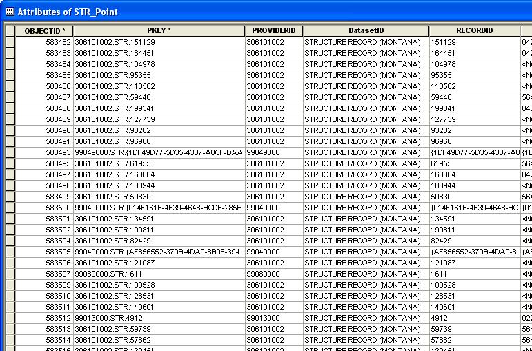
11 Description Examples: A BMSC created record in the Structures Framework: STR.848 A Lewis & Clark County provided record in the Structures Framework: ArcGIS-maintained GlobalID STR.{4477EDAF BE-BB7E-A73D31101A73} A GNIS provided record in the Geographic Names Framework: 1434.GNM GNIS ID
12 Implementation Couple ways to implement Maintain all four parts as individual fields in the attribute table Advantages: makes it easier to sort and query by any of the parts; easy to calculate the full PKEY Disadvantages: more fields in the attribute table; provider and dataset IDs don t usually change so there is redundant data

13 Implementation
14 Implementation Maintain the two parts that change, PKEY and the record (local) identifier Advantages: minimized the number of extra fields needed and redundant data Disadvantages: more difficult sorts / queries;
15 Summary Unique identifiers are a good idea for any database The MAGIP Persistent Identifier Best Practice is a proven unique identifier format and is ideal for GIS datasets that integrate data from multiple providers OR for GIS data that is contributed to federated datasets Questions, comments?
Presented by Kit Na Goh
 Developing A Geo-Spatial Search Tool Using A Relational Database Implementation of the FGDC CSDGM Model Presented by Kit Na Goh Introduction Executive Order 12906 was issued on April 13, 1994 with the
Metadata or "data about data" describe the content, quality, condition, and other characteristics of data. The Federal Geographic Data Committee
 Metadata or "data about data" describe the content, quality, condition, and other characteristics of data. The Federal Geographic Data Committee (http://www.fgdc.gov/) approved the Content Standard for
HYDRODESKTOP VERSION 1.4 QUICK START GUIDE
 HYDRODESKTOP VERSION 1.4 QUICK START GUIDE A guide to using this free and open source application for discovering, accessing, and using hydrologic data February 8, 2012 by: Tim Whiteaker Center for Research
Map Direct Lite. Quick Start Guide: Map Layers 5/14/2018
 Map Direct Lite Quick Start Guide: Map Layers 5/14/2018 Contents Quick Start Guide: Map Layers... 1 Map Layers in Map Direct Lite.... 3 What is a Basemap Layer?... 4 Change the Basemap Using the Basemap
STATEWIDE CENTERLINE INITIATIVE EDITED: MAY 17, 2013
 STATEWIDE CENTERLINE INITIATIVE EDITED: MAY 17, 2013 WHAT IS THE CENTERLINE INITIATIVE? The Centerline Initiative is a joint effort between the Minnesota Department of Transportation (MnDOT), Minnesota
The Proposed Road Centerline Standard for Minnesota Overview and Frequently Asked Questions
 The Proposed Road Centerline Standard for Minnesota Overview and Frequently Asked Questions Introduction. Road Centerlines are a foundational geospatial dataset for Minnesota. They are a foundational data
STATEMENT OF WORK BETWEEN UNIVERSITY SERVICES PMO and ENVIRONMENTAL SYSTEMS RESEARCH INSTITUTE INC. for the GIS Interactive Campus Web Map Project
 STATEMENT OF WORK BETWEEN UNIVERSITY SERVICES PMO and ENVIRONMENTAL SYSTEMS RESEARCH INSTITUTE INC. for the GIS Interactive Campus Web Map Project I. Scope This Statement of Work (SOW) is effective May
Washington Statewide Trails Database Project
 Washington Statewide Trails Database Project Project Overview Washington still is missing a statewide trails database. To date, some of the state and federal hiking, biking, horse and rail trails data
History of NERC December 2012
 History of NERC December 2012 Timeline Date 1962-1963 November 9, 1965 1967 1967-1968 June 1, 1968 July 13-14, 1977 1979 1980 Description Industry creates an informal, voluntary organization of operating
History of NERC August 2013
 History of NERC August 2013 Timeline Date 1962 1963 November 9, 1965 1967 1967 1968 June 1, 1968 July 13 14, 1977 1979 Description The electricity industry creates an informal, voluntary organization of
HYDRODESKTOP VERSION 1.1 BETA QUICK START GUIDE
 HYDRODESKTOP VERSION 1.1 BETA QUICK START GUIDE A guide to help you get started using this free and open source desktop application for discovering, accessing, and using hydrologic data. September 15,
Regional Centers Framework Update. Regional Project Evaluation Committee March 24, 2017
 Regional Centers Framework Update Regional Project Evaluation Committee March 24, 2017 Overview Background Project Overview and Previous Board Direction Overview of Stakeholder Working Group Report Process
Downloading shapefiles and using essential ArcMap tools
 CHAPTER 1 KEY CONCEPTS downloading shapefiles learning essential tools exploring the ArcMap table of contents understanding shapefiles customizing shapefiles saving projects Downloading shapefiles and
Answer the following general questions: 1. What happens when you right click on an icon on your desktop? When you left double click on an icon?
 Name: Date: June 27th, 2011 GIS Boot Camps For Educators Practical: Explore ArcGIS 10 Desktop Tools and functionality Day_1 Lecture 1 Sources: o ArcGIS Desktop help o ESRI website o Getting to Know ArcGIS
Metadata and Encoding Standards for Digital Initiatives: An Introduction
 Metadata and Encoding Standards for Digital Initiatives: An Introduction Maureen P. Walsh, The Ohio State University Libraries KSU-SLIS Organization of Information 60002-004 October 29, 2007 Part One Non-MARC
Coordinate Transformation for Macau Data Using ArcGIS for Desktop
 Coordinate Transformation for Macau Data Using ArcGIS for Desktop Article ID : TT100062 Software : ArcGIS 10.2 for Desktop Platform : Windows 7, Windows 8, Windows Server 2003, Windows Server 2008/R2 Date
Cyber Partnership Blueprint: An Outline
 Approved for Public Release; Distribution Unlimited. 13-3851 The MITRE Corporation Cyber Partnership Blueprint: An Outline October 26, 2013 Copyright 1997-2013, The MITRE Corporation. All rights reserved.
 GUIDELINES FOR DATABASES AS PUBLIC RECORDS PURPOSE... 1 OVERVIEW... 1 POLICY GUIDELINES... 2 OFFICIAL REQUEST... 2 EXEMPT RECORDS... 2 REQUESTS FOR SPECIFIC RECORDS... 3 REQUEST FOR ENTIRE DATABASES OR
Project 2 CIVL 3161 Advanced Editing
 Project 2 CIVL 3161 Advanced Editing Introduction This project will involve more advanced editing/manipulation of data within ArcGIS. You will use the map that you create in this project as a starting
RPMA - Roadway Project Mapping Application
 RPMA - Roadway Project Mapping Application RPMA Training Documentation Version: 1/9/2018 Title of Report 1 Table of Contents Table of Contents...2 Background Info on Roadway Project Mapping Application...3
Migrating Water & Sanitary Data to the Local Government Model using X-Ray for Geodatabases. Margaret Montgomery Darrell Hill May 2, 2016
 Migrating Water & Sanitary Data to the Local Government Model using X-Ray for Geodatabases Margaret Montgomery Darrell Hill May 2, 2016 Agenda Manassas Overview. GIS in Manassas. Local Govt Schema Review
Lab Assignment 4 Basics of ArcGIS Server. Due Date: 01/19/2012
 Lab Assignment 4 Basics of ArcGIS Server Due Date: 01/19/2012 Overview This lab assignment is designed to help you develop a good understanding about the basics of ArcGIS Server and how it works. You will
Best Practices for Designing Effective Map Services
 FedGIS Conference February 24 25, 2016 Washington, DC Best Practices for Designing Effective Map Services James Tedrick, Esri Matt Sokol, MD Dept. of Information Technology Web Mapping & Service Types
For each layer there is typically a one- to- one relationship between geographic features (point, line, or polygon) and records in a table
 and records in a table") For each layer there is typically a one- to- one relationship between geographic features (point, line, or polygon) and records in a table Common components of a database: Attribute (or item or field)
For each layer there is typically a one- to- one relationship between geographic features (point, line, or polygon) and records in a table Common components of a database: Attribute (or item or field)
Unity In diversity. ArcGIS JS API as an Integration Tool. RICARDO BANDEIRA - IplanRio
 Unity In diversity ArcGIS JS API as an Integration Tool RICARDO BANDEIRA - IplanRio Introduction Integrating the processes of an entire City Hall is not an easy task. Decision making requires updated information
Downloading Census Data from American Factfinder for use in ArcGIS
 Downloading Census Data from American Factfinder for use in ArcGIS Written by Barbara Parmenter, revised September 24 2013 OBTAINING DATA FROM AMERICAN FACTFINDER (AFF)... 1 PREPARING AMERICAN FACTFINDER
The TLC GIS Web Development Strategy Tallahassee - Leon County Geographic Information Systems
 The TLC GIS Web Development Strategy Tallahassee - Leon County Geographic Information Systems As presented by Lee Hartsfield, GISP Tallahassee-Leon County GIS Coordinator Outline * Tallahassee-Leon County
GEOFidelis SDSFIE Implementation Roles and Responsibilities Guide
 GEOFidelis SDSFIE Implementation Roles and Responsibilities Guide Version: 1.4 Prepared for: USMC Installation Geospatial Information and Services Program (GEOFidelis) November 19th, 2012 TABLE OF CONTENTS
PROCEDURE POLICY DEFINITIONS AD DATA GOVERNANCE PROCEDURE. Administration (AD) APPROVED: President and CEO
 APPROVED: President and CEO") Section: Subject: Administration (AD) Data Governance AD.3.3.1 DATA GOVERNANCE PROCEDURE Legislation: Alberta Evidence Act (RSA 2000 ca-18); Copyright Act, R.S.C., 1985, c.c-42; Electronic Transactions
Section: Subject: Administration (AD) Data Governance AD.3.3.1 DATA GOVERNANCE PROCEDURE Legislation: Alberta Evidence Act (RSA 2000 ca-18); Copyright Act, R.S.C., 1985, c.c-42; Electronic Transactions
Attribute data management
 LA561 Computer Applications in LA (GIS) Attribute data management Dr. Ragab Khalil Department of Landscape Architecture Faculty of Environmental Design King AbdulAziz University Room 103 Overview Using
ESINets and Map Based Location Technology Use
 WHITE PAPER DEFENDING WORLD SECURITY Emergency Services IP NetworkS ESINets and Map Based Location Technology Use Page 1 The reproduction, distribution and use of this document as well as the communication
How to Create Metadata in ArcGIS 10.0
 How to Create Metadata in ArcGIS 10.0 March 2012 Table of Contents Introduction... 1 Getting Started... 2 Software Requirements... 2 Configure ArcGIS Desktop to View FGDC Metadata... 2 Other Thoughts...
The What, Why, Who and How of Where: Building a Portal for Geospatial Data. Alan Darnell Director, Scholars Portal
 The What, Why, Who and How of Where: Building a Portal for Geospatial Data Alan Darnell Director, Scholars Portal What? Scholars GeoPortal Beta release Fall 2011 Production release March 2012 OLITA Award
An Introduction to PREMIS. Jenn Riley Metadata Librarian IU Digital Library Program
 An Introduction to PREMIS Jenn Riley Metadata Librarian IU Digital Library Program Outline Background and context PREMIS data model PREMIS data dictionary Implementing PREMIS Adoption and ongoing developments
Brooke Roegge. Digital Information Specialist Minnesota Dept. of Employment and Economic Development
 Editing Existing Items in CONTENTdm s Project Client Brooke Roegge Digital Information Specialist Minnesota Dept. of Employment and Economic Development November 14, 2011 Open an existing collection in
California GIS Enterprise Strategy
 California GIS Enterprise Strategy David Harris Geospatial Information Officer California Natural Resources Agency December 3, 2009 Outline OCIO / GIO Background California GIS Task Force Report California
CHARTER OUR MISSION OUR OBJECTIVES OUR GUIDING PRINCIPLES
 OUR MISSION Promote the highest level of safety for the U.S. offshore oil and natural gas industry through effective leadership, communication, teamwork, utilization of disciplined management systems and
An overview of the OAIS and Representation Information
 An overview of the OAIS and Representation Information JORUM, DCC and JISC Forum Long-term Curation and Preservation of Learning Objects February 9 th 2006 University of Glasgow Manjula Patel UKOLN and
7. METHODOLOGY FGDC metadata
 7. METHODOLOGY To enable an Internet browsing client to search and discover information through a federated metadatabase, four elements must be in place. 1. The client must be able to communicate with
Compass INSPIRE Services. Compass INSPIRE Services. White Paper Compass Informatics Limited Block 8, Blackrock Business
 Compass INSPIRE Services White Paper 2010 Compass INSPIRE Services Compass Informatics Limited Block 8, Blackrock Business Park, Carysfort Avenue, Blackrock, County Dublin, Ireland Contact Us: +353 1 2104580
This document is a preview generated by EVS
 INTERNATIONAL STANDARD ISO 10160 Third edition 2015-05-01 Information and documentation Open Systems Interconnection Interlibrary Loan Application Service Definition Information et documentation Interconnexion
The Address Point Data Standard for Minnesota Overview and Frequently Asked Questions
 The Address Point Data Standard for Minnesota Overview and Frequently Asked Questions Introduction. Address points are a core geospatial infrastructure dataset for Minnesota. They are a foundational data
ITU-T I.570. Public/private ISDN interworking. SERIES I: INTEGRATED SERVICES DIGITAL NETWORK Internetwork interfaces. Recommendation ITU-T I.
 I n t e r n a t i o n a l T e l e c o m m u n i c a t i o n U n i o n ITU-T I.570 TELECOMMUNICATION STANDARDIZATION SECTOR OF ITU (01/2018) SERIES I: INTEGRATED SERVICES DIGITAL NETWORK Internetwork interfaces
GEOSS Data Management Principles: Importance and Implementation
 GEOSS Data Management Principles: Importance and Implementation Alex de Sherbinin / Associate Director / CIESIN, Columbia University Gregory Giuliani / Lecturer / University of Geneva Joan Maso / Researcher
Global Reference Architecture: Overview of National Standards. Michael Jacobson, SEARCH Diane Graski, NCSC Oct. 3, 2013 Arizona ewarrants
 Global Reference Architecture: Overview of National Standards Michael Jacobson, SEARCH Diane Graski, NCSC Oct. 3, 2013 Arizona ewarrants Goals for this Presentation Define the Global Reference Architecture
A FRAMEWORK FOR MAINTAINING A MULTI-USER GEODATABASE: AN EMPIRICAL EXAMPLE. Muniru Ayotunde Owoola PhD
 A FRAMEWORK FOR MAINTAINING A MULTI-USER GEODATABASE: AN EMPIRICAL EXAMPLE Muniru Ayotunde Owoola PhD GIS Manager, Maltais Geomatics Inc. 70 0 Avenue, NW Edmonton, AB TP L Canada tunde@maltaisgeomatics.com
ESRI Technology Update. Joe Holubar Larry Young
 ESRI Technology Update Joe Holubar Larry Young Continued Improvement Improving Quality and Extending and Refining Functionality First Half of 2009: Minor Update Release (ArcGIS 9.3.1) ArcGIS Explorer Fall
Relational Database Components
 Relational Database Components Chapter 2 Class 01: Relational Database Components 1 Class 01: Relational Database Components 2 Conceptual Database Design Components Class 01: Relational Database Components
Enterprise Geographic Information Servers. Dr David Maguire Director of Products Kevin Daugherty ESRI
 Enterprise Geographic Information Servers Dr David Maguire Director of Products Kevin Daugherty ESRI Outline Introduction Enterprise GIS vs. Spatially-enabled IS Architectures for building Enterprise GIS
USING WEB APPBUILDER TO TRACK TEMPORARY WATER METER DEPLOYMENTS. Olivia DeSimone, GISP GIS Analyst City of Altamonte Springs
 USING WEB APPBUILDER TO TRACK TEMPORARY WATER METER DEPLOYMENTS Olivia DeSimone, GISP GIS Analyst City of Altamonte Springs CITY OF ALTAMONTE SPRINGS Located in Seminole County (Central Florida) Seminole
Geodatabases. Dr. Zhang SPRING 2016 GISC /03/2016
 Geodatabases Dr. Zhang SPRING 2016 GISC 1401 10/03/2016 Using and making maps Navigating GIS maps Map design Working with spatial data Spatial data infrastructure Interactive maps Map Animations Map layouts
Hank Garie Executive Director of GOS Keynote Speaker. National States Geographic Information Council Annual Meeting Nashville, TN
 Hank Garie Executive Director of GOS Keynote Speaker National States Geographic Information Council 2003 Annual Meeting Nashville, TN Compiled by Jim Steil, Mississippi State University *Disclaimer: Please
ArcGIS Enterprise: An Introduction. David Thom Solution Engineer State Government
 ArcGIS Enterprise: An Introduction David Thom Solution Engineer State Government What is ArcGIS Enterprise? ArcGIS Enterprise is server software that allows you to use infrastructure you manage to implement
Iowa Department of Transportation Statewide Coordinated GIS
 1998 TRANSPORTATION CONFERENCE PROCEEDINGS 187 Iowa Department of Transportation Statewide Coordinated GIS WILLIAM G. SCHUMAN, TIM STRAUSS, DAN GIESEMAN, AND REGINALD R. SOULEYRETTE This paper details
ArcGIS for Server: Security
 DevSummit DC February 11, 2015 Washington, DC Michael Sarhan Esri msarhan@esri.com Agenda Review Basic Security Workflow - ArcGIS Server Roles and Identity Stores - Authentication - Authorization: Securing
ISO INTERNATIONAL STANDARD. Geographic information Filter encoding. Information géographique Codage de filtres. First edition
 INTERNATIONAL STANDARD ISO 19143 First edition 2010-10-15 Geographic information Filter encoding Information géographique Codage de filtres Reference number ISO 19143:2010(E) ISO 2010 PDF disclaimer This
Analyze search results by using charts and graphs on a dedicated dashboard. Nexis Media Coverage Analyzer User Guide
 Nexis Media Coverage Analyzer User Guide Analyze search results by using charts and graphs on a dedicated dashboard Nexis Media Coverage Analyzer is a new add-on module for nexis.com with a dedicated dashboard
I n t e r n a t i o n a l T e l e c o m m u n i c a t i o n U n i o n
 I n t e r n a t i o n a l T e l e c o m m u n i c a t i o n U n i o n ITU-T Q.3623 TELECOMMUNICATION STANDARDIZATION SECTOR OF ITU (02/2016) SERIES Q: SWITCHING AND SIGNALLING Signalling requirements and
Metadata Requirements for SanGIS Data Layers
 Metadata Requirements for SanGIS Data Layers What is Metadata? Metadata is data about data. It is information in addition to the spatial and tabular data that is required to make the data useful. Metadata
Worksheet for minimally-compliant FGDC metadata
 Metadata Worksheet P. 1 of 8 Worksheet for minimally-compliant FGDC metadata The purpose of this worksheet is to provide an outline for high level geospatial metadata information gathering. It should help
Securing ArcGIS Services
 Federal GIS Conference 2014 February 10 11, 2014 Washington DC Securing ArcGIS Services James Cardona Agenda Security in the context of ArcGIS for Server Background concepts Access Securing web services
Key Terms. Attribute join Target table Join table Spatial join
 Key Terms Attribute join Target table Join table Spatial join Lect 10A Building Geodatabase Create a new file geodatabase Map x,y data Convert shape files to geodatabase feature classes Spatial Data Formats
Highway Advertising Sign Mobile Data Capture and Permit Management GIS OAPRT Mobile and OAPRT Web-based Applications
 Highway Advertising Sign Mobile Data Capture and Permit Management GIS OAPRT Mobile and OAPRT Web-based Applications Client Minnesota Department of Transportation (Mn/DOT) St. Paul, Minnesota Project In
Homework 2; Down load instructions and data from Web Can load.dbf in to ArcMap and use Select by Attributes
 Homework 2; Down load instructions and data from Web Can load.dbf in to ArcMap and use Select by Attributes Submit via Moodle using HomeWork2 Answer Sheet Quiz Homework on Website Homework 2; Down load
Simile Tools Workshop Summary MacKenzie Smith, MIT Libraries
 Simile Tools Workshop Summary MacKenzie Smith, MIT Libraries Intro On June 10 th and 11 th, 2010 a group of Simile Exhibit users, software developers and architects met in Washington D.C. to discuss the
Academic Program Review at Illinois State University PROGRAM REVIEW OVERVIEW
 Academic Program Review at Illinois State University PROGRAM REVIEW OVERVIEW For Research and Service Centers Submitting Self-Study Reports Fall 2017 INTRODUCTION Primary responsibility for maintaining
ADVANCED GEOGRAPHIC INFORMATION SYSTEMS Vol. II - Geospatial Interoperability : The OGC Perspective Open Geospatial Consortium, Inc.
 GEOSPATIAL INTEROPERABILITY: THE OGC PERSPECTIVE Open Open Geospatial Consortium, Wayland, MA, USA Keywords: geographic information systems, geospatial services, interoperability, interface specification,
GEOGRAPHIC INFORMATION SYSTEMS Lecture 02: Feature Types and Data Models
 GEOGRAPHIC INFORMATION SYSTEMS Lecture 02: Feature Types and Data Models Feature Types and Data Models How Does a GIS Work? - a GIS operates on the premise that all of the features in the real world can
SHARING GEOGRAPHIC INFORMATION ON THE INTERNET ICIMOD S METADATA/DATA SERVER SYSTEM USING ARCIMS
 SHARING GEOGRAPHIC INFORMATION ON THE INTERNET ICIMOD S METADATA/DATA SERVER SYSTEM USING ARCIMS Sushil Pandey* Birendra Bajracharya** *International Centre for Integrated Mountain Development (ICIMOD)
Chapter 7. Joining Maps to Other Datasets in QGIS
 Chapter 7 Joining Maps to Other Datasets in QGIS Skills you will learn: How to join a map layer to a non-map layer in preparation for analysis, based on a common joining field shared by the two tables.
County of Los Angeles. Chief Information Office Preferred Technologies for Geographic Information Systems (GIS) Version 2 May 2015
 Version 2 May 2015") County of Los Angeles Chief Information Office Preferred Technologies for Geographic Information Systems (GIS) Version 2 May 2015 CIO Preferred Technologies for GIS This document lists the preferred Geographic
County of Los Angeles Chief Information Office Preferred Technologies for Geographic Information Systems (GIS) Version 2 May 2015 CIO Preferred Technologies for GIS This document lists the preferred Geographic
Introduction to Geodatabase and Spatial Management in ArcGIS. Craig Gillgrass Esri
 Introduction to Geodatabase and Spatial Management in ArcGIS Craig Gillgrass Esri Session Path The Geodatabase - What is it? - Why use it? - What types are there? - What can I do with it? Query Layers
SERIES M: TELECOMMUNICATION MANAGEMENT, INCLUDING TMN AND NETWORK MAINTENANCE Telecommunications management network
 International Telecommunication Union ITU-T M.3348 TELECOMMUNICATION STANDARDIZATION SECTOR OF ITU (01/2011) SERIES M: TELECOMMUNICATION MANAGEMENT, INCLUDING TMN AND NETWORK MAINTENANCE Telecommunications
ArcGIS Online (AGOL) Quick Start Guide Fall 2018
 Quick Start Guide Fall 2018") ArcGIS Online (AGOL) Quick Start Guide Fall 2018 ArcGIS Online (AGOL) is a web mapping tool available to UC Merced faculty, students and staff. The Spatial Analysis and Research Center (SpARC) provides
ArcGIS Online (AGOL) Quick Start Guide Fall 2018 ArcGIS Online (AGOL) is a web mapping tool available to UC Merced faculty, students and staff. The Spatial Analysis and Research Center (SpARC) provides
Introduction to Geographic Information Systems Spring 2016
 Introduction to Geographic Information Systems Spring 2016 Exercise 2 Introduction to ArcGIS 10 Projects This exercise will introduce you to the common set-up functions of the ESRI ArcGIS software package.
Introduction to Geographic Information Science. Updates. Last Lecture. Geography 4103 / Database Management
 Geography 4103 / 5103 Introduction to Geographic Information Science Database Management Updates Last Lecture We tried to explore the term spatial model by looking at definitions, taxonomies and examples
INSPIRE status report
 INSPIRE Team INSPIRE Status report 29/10/2010 Page 1 of 7 INSPIRE status report Table of contents 1 INTRODUCTION... 1 2 INSPIRE STATUS... 2 2.1 BACKGROUND AND RATIONAL... 2 2.2 STAKEHOLDER PARTICIPATION...
PNAMP Metadata Builder Prototype Development Summary Report December 17, 2012
 PNAMP Metadata Builder Prototype Development Summary Report December 17, 2012 Overview Metadata documentation is not a commonly embraced activity throughout the region. But without metadata, anyone using
Envirocat: a Swiss Catalogue for Sharing Environmental Information
 Envirocat: a Swiss Catalogue for Sharing Environmental Information Karin Fink 1, Véronique Ortner 1, Hy Dao 2, Jean-Philippe Richard 3, Frédéric Vogel 3 Summary This paper presents the envirocat 4 project,
Geocoding Address Data
 Geocoding Address Data First, you need to download the dataset for this exercise from out web server at http://www.library.yale.edu/mapcoll/beta/files/data/geocode_data.zip. Create a folder (use your initials
Unique Object Identifiers
 TM dnf0011 Unique Object Identifiers Component 2.1: Identifier Management Technical Guide Version 1 Unique Object Identifiers Page 1 of 6 Document Content Jonathan Simmons is responsible for the content
Creating the Data Layer
 Creating the Data Layer When interacting with any system it is always useful if it remembers all the settings and changes between visits. For example, Facebook has the details of your login and any conversations
D2K Support for Standard Content Repositories: Design Notes. Request For Comments
 D2K Support for Standard Content Repositories: Design Notes Request For Comments Abstract This note discusses software developments to integrate D2K [1] with Tupelo [6] and other similar repositories.
21 st BSHC Meeting Agenda item C September 2016 BSBD-WG Report Klaipeda, Lithuania
 21 st BSHC Meeting Agenda item C3 27 29 September 2016 BSBD-WG Report Klaipeda, Lithuania Sweden BSBD-WG Report to the BSHC 21 st Conference The Baltic Sea Bathymetry Database Working Group has not held
IndianaMap Release 3. Rick Hill, Paul Rohwer,, Chris Dintaman, Becky Meyer, and Denver Harper
 IndianaMap Release 3 Rick Hill, Paul Rohwer,, Chris Dintaman, Becky Meyer, and Denver Harper IndianaMap Agenda Session 1 & 2 Overview Tentative rollout schedule Old versus New Design and construction of
Appendix 1: FGDC Press Release
 Appendix 1: FGDC Press Release The United States Geological Survey Federal Geographic Data Committee (FGDC) has awarded $32,150 to the Wyoming State Historic Preservation Office to develop a metadata standard
Introduction to GIS & Mapping: ArcGIS Desktop
 Introduction to GIS & Mapping: ArcGIS Desktop Your task in this exercise is to determine the best place to build a mixed use facility in Hudson County, NJ. In order to revitalize the community and take
For each use case, the business need, usage scenario and derived requirements are stated. 1.1 USE CASE 1: EXPLORE AND SEARCH FOR SEMANTIC ASSESTS
 1 1. USE CASES For each use case, the business need, usage scenario and derived requirements are stated. 1.1 USE CASE 1: EXPLORE AND SEARCH FOR SEMANTIC ASSESTS Business need: Users need to be able to
Reducing Consumer Uncertainty
 Spatial Analytics Reducing Consumer Uncertainty Towards an Ontology for Geospatial User-centric Metadata Introduction Cooperative Research Centre for Spatial Information (CRCSI) in Australia Communicate
GEO 425: SPRING 2012 LAB 9: Introduction to Postgresql and SQL
 GEO 425: SPRING 2012 LAB 9: Introduction to Postgresql and SQL Objectives: This lab is designed to introduce you to Postgresql, a powerful database management system. This exercise covers: 1. Starting
LAB 1: Introduction to ArcGIS 8
 LAB 1: Introduction to ArcGIS 8 Outline Introduction Purpose Lab Basics o About the Computers o About the software o Additional information Data ArcGIS Applications o Starting ArcGIS o o o Conclusion To
Use That SAP to Write Your Code Sandra Minjoe, Genentech, Inc., South San Francisco, CA
 Paper DM09 Use That SAP to Write Your Code Sandra Minjoe, Genentech, Inc., South San Francisco, CA ABSTRACT In this electronic age we live in, we usually receive the detailed specifications from our biostatistician
GEOSPATIAL ERDAS APOLLO. Your Geospatial Business System for Managing and Serving Information
 GEOSPATIAL ERDAS APOLLO Your Geospatial Business System for Managing and Serving Information ERDAS APOLLO Do you have large volumes of data, a geographicallydistributed user base and rapidly changing
Geocoding Address Data
 Preparing for the tutorial Geocoding Address Data First, you need to download the dataset for this exercise from out web server at http://www.library.yale.edu/mapcoll/files/data/geocode_data.zip. Create
Good morning. The MoMA Archives has been very busy this past year and before I begin my main presentation I want to shamelessly promote two
 Good morning. The MoMA Archives has been very busy this past year and before I begin my main presentation I want to shamelessly promote two particular activities that have taken up our time. 1 The first
Working with 2000 Census Data in ArcGIS: Using the US Census Bureau Web Site for SF1 and SF3 Data
 Tufts University GIS Tutorial Working with 2000 Census Data in ArcGIS: Using the US Census Bureau Web Site for SF1 and SF3 Data Revised October 14, 2010 Note: we highly recommend Mozilla Firefox for this
ArcGIS Server: publishing geospatial data to the web using the EEA infrastructure
 ArcGIS Server: publishing geospatial data to the web using the EEA infrastructure *IMPORTANT: Map Services should be published using the EEA Map Services Tick Sheet for guidance. Contact Sebastien Petit
Physical Security Reliability Standard Implementation
 Physical Security Reliability Standard Implementation Attachment 4b Action Information Background On March 7, 2014, the Commission issued an order directing NERC to submit for approval, within 90 days,
CLICK HERE TO KNOW MORE
 CLICK HERE TO KNOW MORE GeoSmart Asia 2015 The importance of Geospatial Data Standardisation in GIS Corporate Database 30 September 2015 Khairul Faizi B Mohd Taib Technical Data, Technical Global PETRONAS