Forestry Data Model User Guide. Version 2.0 January, 2013
|
|
|
- Clinton Casey
- 6 years ago
- Views:
Transcription
1 Forestry Data Model User Guide Version 2.0 January, 2013
2 Table of Contents Introduction... 1 Advantages of Using a Geodatabase... 1 Subtypes and Domains... 2 Subtypes... 2 Domains... 3 The Forestry Data Model... 3 Migrating to the Forestry Data Model... 5 Step 1: Data Migration Matrix... 5 Step 2: Prepare Source Data... 6 Step 3: Data Migration... 9 Feedback Importing Additional Feature Classes to the Forestry Geodatabase... 12

3 Introduction This guide is intended to help you migrate your existing data into the Forestry Data Model. The purpose is to support the day-to-day work that you do as well as new requirements for additional map products, reports, and analysis. This guide includes some introductory information to highlight why using a geodatabase format is valuable and provides some guidelines regarding using the Forestry Data Model structure. Following this, there are strategies and instructions to help you migrate your organization's source data into this new Forestry Data Model format. It's important that you share your ideas and feedback to ensure the geodatabase design meets your needs. Whether it's a specific change or more general requirements suggestion you'd like to see in the next version, we are looking forward to getting your input. There is also some information to help guide you through reporting your results. Advantages of Using a Geodatabase There are some key advantages to using the geodatabase format as opposed to storing your data in shapefiles or coverages. There are many comprehensive resources available on this topic, so this section simply includes a high-level overview of the geodatabase from esri.com/software/arcgis/geodatabase and links to additional articles and podcasts on this topic. 1
4 The geodatabase offers you the ability to do the following: Store a rich collection of spatial data in a centralized location Apply sophisticated rules and relationships to the data Define advanced geospatial relational models (e.g., topologies, networks) Maintain integrity of spatial data with a consistent, accurate database Work within a multiuser access and editing environment Integrate spatial data with other IT databases Easily scale your storage solution Support custom features and behavior Leverage your spatial data to its full potential Some additional resources for more information about the geodatabase are below: video.arcgis.com/watch/95/geodatabase-essentials-part-1-an-introduction-to-the-geodatabase video.arcgis.com/watch/101/geodatabase-essentials-part-2-_dash _-an-introduction-to-arcsde-geodatabases Subtypes and Domains Once you upgrade to the geodatabase you get the added benefits of using subtypes. The subsections below give a brief description of each: Subtypes Subtypes are a subset of features in a feature class, or objects in a table, that share the same attributes. They are used as a method to categorize your data, eliminating repetitive data entry and ensuring data consistency. Subtypes allow you to do the following: Increase the performance of the geodatabase by representing a variety of real-world objects as a subset of features in a given feature class instead of creating new feature classes for each object (For example, the forest roads in a forest roads feature class could be categorized into two subtypes: public roads and private roads.) Set a default value that will automatically be applied when creating new features (For example, a subtype for trail access type can be created and defined so that whenever a trail is added to the feature class, its access type is automatically set to private.) Apply coded or ranged domains to features, enabling you to constrain input information to a valid set of values (For example, the trails cover type can have a coded domain for restricting them to be asphalt, gravel, or dirt.) Some additional resources providing more information about subtypes can be found here: help.arcgis.com/en/arcgisdesktop/10.0/help/index.html#/working_with_subtypes /005r / help.arcgis.com/en/arcgisdesktop/10.0/help/index.html#/creating_subtypes /005r / 2
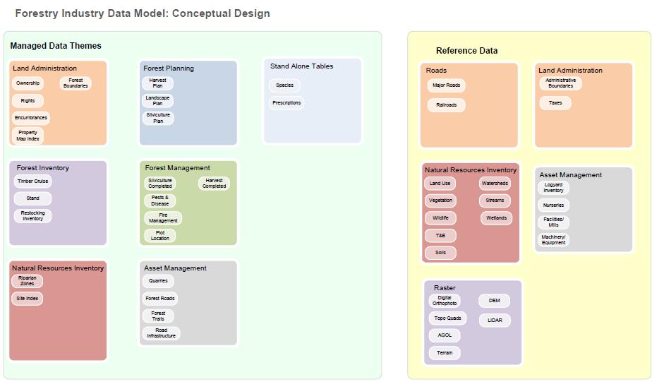
5 Domains Attribute domains are used to constrain the values allowed in any particular attribute for a table or feature class and are often referred to as the list of acceptable values. In other words, the field will not accept a value that is not in that domain. If the features in a feature class or nonspatial objects in a table have been grouped into subtypes, then different attribute domains can also be assigned to each of the subtypes. More information about domains and the different types of domains can be found here: help.arcgis.com/en/arcgisdesktop/10.0/help/index.html#//001s htm The Forestry Data Model A conceptual high-level diagram of the Forestry Data Model is below (A complete logical diagram is included in the review package): 3
6 4
7 Migrating to the Forestry Data Model Migrating data into the Forestry Data Model can be broken down into three steps: 1. Design a matrix to indicate how source data maps into the target Forestry Data Model. 2. Prepare your source data to simplify the data migration process. 3. Migrate your source data into the Forestry Data Model using the Simple Data Loader in ArcCatalog. Note: An alternative option is to use ModelBuilder or the Data Interoperability extension to build an automated tool to complete steps 2 and 3. This would be preferable when you envision needing to perform iterative updates to the data migration process or perform the data migration multiple times. In this guide, the focus is on the simplest and most efficient way to get some sample data into the geodatabase, so these topics are not covered. Step 1: Data Migration Matrix The first step in the data migration process is to identify and document how your source data will map to the target Forestry Data Model in a Data Migration Matrix. This requires an understanding of the types, formats, and structure of the source data maintained by your organization and in the target Forestry Data Model. At a minimum, this matrix identifies which source shapefiles, coverages, feature classes, and tables will be migrated to which target feature classes and tables. It may also include notes on additional ways the data is to be manipulated during the data migration such as filtering data that meets specified criteria or mapping attribute values. During this process, you will likely find that some of your organization's data aligns very closely with the Forestry Data Model and will be very simple to migrate. In other scenarios, you may find that you have the types of information captured in the Forestry Data Model but that your data is in a different format or structure. Both of these scenarios are captured in the Data Migration Matrix. Note that it's acceptable if you do not have all the features or attributes that are included in the Forestry Data Model those simply won't be included in the data migration. If you have additional types of features or attributes that are not included in the current version of the model, please include that in your feedback. A sample Data Migration Matrix is below: Source: My Organization's Target: Forestry Data Model Notes Data Ownership Area OwnershipPl - OwnershipID - Owner - OwnerName - Type - OwnershipType Source is string; target is short integer with domain; need to preprocess data - Phone - Transportation ForestRoads Only Road features (Type = Road) Transportation ForestTrails Only Trail features (Type = Trail) 5
8 It's not important that the documentation is complete, but the process of filling in the data migration matrix will help you define the work required in steps 2 and 3. Tip: To fill out this matrix, try creating some new data in the target geodatabase using the ArcMap editing tools. This will help you learn more about the structure and format of the Forestry Data Model and how your data could be translated to this new format. Step 2: Prepare Source Data The second step in the data migration process is to preprocess data so that it can be loaded into the geodatabase using the Simple Data Loader. Some basic requirements apply: Source and Target geometry types must be identical or compatible. For example, you cannot load a point shapefile into a polygon feature class. Source and Target field types must be identical or compatible. For example, you cannot load string values into a short integer field. Source data values and characteristics should adhere to rules specified in the Forestry Data Model. For example, where a subtype or domain is applied to a field, the values in the source data must match the codes included in that subtype or domain to be migrated correctly. Note: This rule is not enforced by the Simple Data Loader tool. In cases where the above requirements are not met for your source data, some preprocessing is required. Primarily, this will involve adding new fields to your source data and calculating values to match the structure and format of the Forestry Data Model. For example, consider the ownership type scenario from the Data Migration Matrix: Source: My Organization's Target: Forestry Data Model Notes Data Ownership Area OwnershipPl - Type - OwnershipType Source is string; target is short integer with domain; need to preprocess data In your source data, you have an Ownership Area shapefile. This shapefile includes a Type string field with data values such as Forest Industry, Investor Timberland, and Non-Industrial land. However, in the Forestry Data Model, this type of information is captured in the OwnershipType field, which is a short integer field and includes values such as 1, representing Forest Industry Land, or 2, representing Investor Timberland. It's important to point out that subtypes and domains have both a code and description. The code is the data value stored in the geodatabase (for example, the code can be 1, 2, or 3, as shown in the diagram below), while the description is displayed to the user in ArcMap or ArcCatalog (for example, Forest Industry Land). 6


9 To preprocess your data, you will create a new field in your source dataset and populate this field with values that match the Forestry Data Model codes (not descriptions). An example is provided below: 1. Add a new field to your source data that better matches the Forestry Data Model schema. a. In ArcMap, open the ArcCatalog window. b. In the ArcCatalog window, browse to your Ownership Area shapefile, right-click, and choose Properties. c. Ensure the Fields tab is active. d. In the Shapefile Properties window, add a new field (Name = OwnerType; Data Type = Short Integer) and click OK. Note: Due to field length limitation in shapefiles, the new field is named OwnerType vs. OwnershipType in target geodatabase. These fields will be mapped in Step 5 of the Data migration process. 2. Next, select features from the Ownership Area shapefile where Type = Forest Industry Land. 7
. b. Right-click a new OwnerType field and click Field Calculator.")
10 a. In ArcMap, drag the Ownership Area shapefile to your table of contents. b. From the menu, click Selection and Select by Attributes. c. Use the Query Builder to select Forest Industry Land features. See the example below: 3. Finally, calculate values in the new OwnerType field. a. Open the attribute table (you will see that the Forest Industry Land features are selected). b. Right-click a new OwnerType field and click Field Calculator. c. Calculate OwnerType = 1. See the example below. 8


11 4. Repeat steps 2 and 3 for each value in your source data that you want to translate to the Forestry Data Model format. As you make these changes, remember to update your Data Migration Matrix, which you'll use in the next step. Step 3: Data Migration The final step is to load your source data into the geodatabase. The Simple Data Loader will be used in this scenario. Follow the information in the Data Migration Matrix to complete this step. 1. In ArcCatalog, browse to the Forestry Data Model and right-click the feature class you'd like to load data into, then click Load and Load Data. 9


12 2. Click Next to advance. 3. Browse to your source data, which was preprocessed in step 2, then click Add to add it to the list of source data to be loaded. Click Next. 4. On the next page of the wizard, you must choose if you want to load features into a subtype. This is not necessary if you have already preprocessed your data including calculating a new field with the valid subtype codes where they exist. Click Next. 10


13 5. Use the information in the Data Migration Matrix to map fields to the target Forestry Data Model from your source dataset. See the Ownership example below. When satisfied, click Next. 6. Choose if you want to load all the data in the source dataset or only a subset. In most scenarios, you will want to load all the source data. An example scenario where you may want to load a subset is where you have a status field that indicates if the feature is active or retired. In this type of scenario, you may decide to load only the active features into the new geodatabase. This type of information could also be included in the Data Migration Matrix, or you could update the documentation as you discover these requirements. Click Next. 7. On the final page, review the summary and click Finish to load the data. 11

14 8. From here, you can validate the results of your data load and continue to refine your data migration process if necessary. Add both the source and target feature class to ArcMap and review a sample set of features to make sure the data migration was successful. Use the Identify tool to verify that attributes were translated successfully. Once satisfied with your results, move on to testing. Feedback Providing feedback is voluntary yet it is appreciated. Please try to perform the regular mapping, analysis, and reporting functions you need to do in your daily work. You can also try to accomplish something new that you're hoping this data model will support. Please provide some brief documentation in the format below. Questions, comments, and ideas are all welcome as we work on improving the data model, expanding the Forestry resource center, and supporting you in your work. Please your feedback to forestry@esri.com. Joe Contact Question Comments and Ideas Priority I'm having trouble loading data into the stand feature class. The error message is "XYZ." Don Please add values X, Y, and Z to the dfiretype domain. Sarah I'd like to create a map and report that shows "XYZ." Please see the attached example. This is high priority. <Brief explanation on usage>. Importing Additional Feature Classes to the Forestry Geodatabase The Forestry Data Model was intended as a base model to serve the forestry industry. It contains the most common feature classes and datasets used but may lack some key datasets specific to your 12
15 organization or datasets typically used as reference data. The following links provide some information regarding the ways you can extend the data model. This includes importing shapefiles, coverages, CAD data, or feature classes that you may have in an existing geodatabase: help.arcgis.com/en/arcgisdesktop/10.0/help/index.html#/about_importing_feature_classes /003n / help.arcgis.com/en/arcgisdesktop/10.0/help/index.html#/importing_a_feature_class_multiple /003n / help.arcgis.com/en/arcgisdesktop/10.0/help/index.html#/an_overview_of_the_to_geodatabase _toolset/ w000000/ 13
Using the Geodatabase
 Using the Geodatabase February 13, 2002 Presented by: John Stroud, ESRI GeoDatabase Geodatabase comes in two flavors Personal mdb format ArcSDE rdbms format ArcGIS is a suite of three products ArcView,
Name: Date: June 27th, 2011 GIS Boot Camps For Educators Lecture_3
 Name: Date: June 27th, 2011 GIS Boot Camps For Educators Lecture_3 Practical: Creating and Editing Shapefiles Using Straight, AutoComplete and Cut Polygon Tools Use ArcCatalog to copy data files from:
LAB 1: Introduction to ArcGIS 8
 LAB 1: Introduction to ArcGIS 8 Outline Introduction Purpose Lab Basics o About the Computers o About the software o Additional information Data ArcGIS Applications o Starting ArcGIS o o o Conclusion To
Object modeling and geodatabases. GEOG 419: Advanced GIS
 Object modeling and geodatabases GEOG 419: Advanced GIS CAD Data Model 1960s and 1970s Geographic data stored as points, lines, and areas No attributes; each feature type stored on a different layer No
Introduction to Geodatabase and Spatial Management in ArcGIS. Craig Gillgrass Esri
 Introduction to Geodatabase and Spatial Management in ArcGIS Craig Gillgrass Esri Session Path The Geodatabase - What is it? - Why use it? - What types are there? - What can I do with it? Query Layers
LSGI 521: Principles of GIS. Lecture 5: Spatial Data Management in GIS. Dr. Bo Wu
 Lecture 5: Spatial Data Management in GIS Dr. Bo Wu lsbowu@polyu.edu.hk Department of Land Surveying & Geo-Informatics The Hong Kong Polytechnic University Contents 1. Learning outcomes 2. From files to
Integrating ArcGIS to Enterprise Oracle Spatial Using Direct Connect
 Integrating ArcGIS to Enterprise Oracle Spatial Using Direct Connect Michael D. Tsengouras Principal Software Engineer Navigation Technologies Corporation Abstract: Many organizations are adopting Enterprise
Annotation/Labeling Workshop. Tim Rankin Pat Dolan
 Annotation/Labeling Workshop Tim Rankin Pat Dolan Agenda 8:00am - Introductions 8:05am - Goals of the Workshop 8:15am Labeling 8:45am Annotation Part I 9:15am Break 9:25am Annotation Part II 9:50am Questions
Working with Events in ArcGIS 8.2
 Working with Events in ArcGIS 8.2 This tutorial is a companion to the article, Understanding Dynamic Segmentation: Working with Events in ArcGIS in the October December 2002 issue of ArcUser magazine.
Geographical Information Systems Institute. Center for Geographic Analysis, Harvard University. LAB EXERCISE 1: Basic Mapping in ArcMap
 Harvard University Introduction to ArcMap Geographical Information Systems Institute Center for Geographic Analysis, Harvard University LAB EXERCISE 1: Basic Mapping in ArcMap Individual files (lab instructions,
Answer the following general questions: 1. What happens when you right click on an icon on your desktop? When you left double click on an icon?
 Name: Date: June 27th, 2011 GIS Boot Camps For Educators Practical: Explore ArcGIS 10 Desktop Tools and functionality Day_1 Lecture 1 Sources: o ArcGIS Desktop help o ESRI website o Getting to Know ArcGIS
ArcMap - EXPLORING THE DATABASE Part I. SPATIAL DATA FORMATS Part II
 Week 5 ArcMap - EXPLORING THE DATABASE Part I SPATIAL DATA FORMATS Part II topics of the week Exploring the Database More on the Table of Contents Exploration tools Identify, Find, Measure, Map tips, Hyperlink,
Select the Parks within Forest Acres
 Select the Parks within Forest Acres TASKS RESULT 1. Add the county boundary, municipalities and parks (pts.) layers to your map 2. Save your map (.mxd) to your desktop Your map should look something like
Using ESRI data in Autodesk ISD Products
 GI13-3 Using ESRI data in Autodesk ISD Products 1.5 hr. Class 02-Dec-03 3:30pm - 5:00pm Session Description: We will focus on using data in a variety of ESRI formats within the Autodesk GIS product line,
Spatial Data Standards for Facilities, Infrastructure, and Environment (SDSFIE)
") Spatial Data Standards for Facilities, Infrastructure, and Environment (SDSFIE) Migration Workflow User Guide Version 1.0 (01 August 2018) Prepared For: US Army Corps of Engineers 2018 Revision History
Spatial Data Standards for Facilities, Infrastructure, and Environment (SDSFIE) Migration Workflow User Guide Version 1.0 (01 August 2018) Prepared For: US Army Corps of Engineers 2018 Revision History
Exercise 1: An Overview of ArcMap and ArcCatalog
 Exercise 1: An Overview of ArcMap and ArcCatalog Introduction: ArcGIS is an integrated collection of GIS software products for building a complete GIS. ArcGIS enables users to deploy GIS functionality
An Introduction to Data Interoperability
 Esri International User Conference San Diego, California 2012 Technical Workshops July 24/25 An Introduction to Data Interoperability Bruce Harold - Esri Dale Lutz Safe Software Background Why Data Interoperability?
ArcGIS Server: publishing geospatial data to the web using the EEA infrastructure
 ArcGIS Server: publishing geospatial data to the web using the EEA infrastructure *IMPORTANT: Map Services should be published using the EEA Map Services Tick Sheet for guidance. Contact Sebastien Petit
Introduction to ArcCatalog
 Introduction to ArcCatalog Introduction To Arc Catalog ArcCatalog is a data- centric GUI tool used for managing spatial data With ArcCatalog you can. Inspect properties and attributes of data Preview and
SilvAssist 3.5 Instruction Manual Instruction Manual for the SilvAssist Toolbar For ArcGIS. Version 3.5
 Instruction Manual for the SilvAssist Toolbar For ArcGIS Version 3.5 1 2 Contents Introduction... 5 Preparing to Use SilvAssist... 6 Polygon Selection... 6 Plot Allocator... 7 Requirements:... 7 Operation...
Compilation of GIS data for the Lower Brazos River basin
 Compilation of GIS data for the Lower Brazos River basin Prepared by Francisco Olivera, Ph.D., P.E., Srikanth Koka, and Lauren Walker Department of Civil Engineering October 2, 2006 Contents: Brief Overview
Geospatial Day II Introduction to ArcGIS Editor for Open Street Map
 Geospatial Day II Introduction to ArcGIS Editor for Open Street Map Geospatial Operations Support Team (GOST) Katie McWilliams kmcwilliams@worldbankgroup.org GOST@worldbank.org 0 Using OSM for Network
ArcGIS Desktop: Introduction to Geoprocessing with ModelBuilder Kevin Armstrong ESRI
 ArcGIS Desktop: Introduction to Geoprocessing with ModelBuilder Kevin Armstrong ESRI SERUG 2008 1 What is ModelBuilder? A user-friendly way to automate a series of tools Part of the ArcGIS geoprocessing
You start model builder through the Geoprocessing > ModelBuilder command:
 ESPM5295 ModelBuilder 1 ModelBuilder Automate Processing ModelBuilder is an ArcMap application that you can use to create processing workflows and tools. You can create something like a flowchart on a
TABLES, ANATOMY OF A TABLE
 week 6 TABLES, ANATOMY OF A TABLE topics of the week Table structure Working with tables Table relationships Cardinality, Joins and Relates Table Jargon What is a Database? What is a Table? What is a Record/Row?
Data Assembling Topics:
 Topics: 1. GPX to Shape file 2. Data conversion with FME 3. Create a polygon feature 4. Merging /Appending data into a new dataset 5. Reproject data from one coordinate system to another 6. Data clipping
Getting to Know ModelBuilder
 Getting to Know ModelBuilder Offered by Shane Bradt through the UNH Cooperative Extension Geospatial Technologies Training Center Developed by Sandy Prisloe and Cary Chadwick at the Geospatial Technology
Model Builder Tutorial (Automating Suitability Analysis)
") Model Builder Tutorial (Automating Suitability Analysis) Model Builder in ArcGIS 10.x Part I: Introduction Part II: Suitability Analysis: A discussion Part III: Launching a Model Window Part IV: A Simple
Model Builder Tutorial (Automating Suitability Analysis) Model Builder in ArcGIS 10.x Part I: Introduction Part II: Suitability Analysis: A discussion Part III: Launching a Model Window Part IV: A Simple
Spatial Data Standards for Facilities, Infrastructure, and Environment (SDSFIE)
") Spatial Data Standards for Facilities, Infrastructure, and Environment (SDSFIE) Model Builder User Guide Version 1.3 (24 April 2018) Prepared For: US Army Corps of Engineers 2018 Revision History Model
Spatial Data Standards for Facilities, Infrastructure, and Environment (SDSFIE) Model Builder User Guide Version 1.3 (24 April 2018) Prepared For: US Army Corps of Engineers 2018 Revision History Model
Explore some of the new functionality in ArcMap 10
 Explore some of the new functionality in ArcMap 10 Scenario In this exercise, imagine you are a GIS analyst working for Old Dominion University. Construction will begin shortly on renovation of the new
Lab 1: Exploring ArcMap and ArcCatalog In this lab, you will explore the ArcGIS applications ArcCatalog and ArcMap. You will learn how to use
 Lab 1: Exploring ArcMap and ArcCatalog In this lab, you will explore the ArcGIS applications ArcCatalog and ArcMap. You will learn how to use ArcCatalog to find maps and data and how to display maps in
ModelBuilder: An Introduction. Kevin Armstrong
 ModelBuilder: An Introduction Kevin Armstrong What is ModelBuilder? A user-friendly way to automate a series of tools Part of the ArcGIS geoprocessing framework - ModelBuilder can run any tool in the ArcToolbox,
ENGRG 59910: Introduction to GIS
 ENGRG 59910: Introduction to GIS Lecture 05: GIS and Databases Basics Acknowledgment: Michael Piasecki Where are we now? Basic geographic concepts Introduction to GIS, coordinate system, projection, datum
Data Interoperability An Introduction
 2013 Esri International User Conference July 8 12, 2013 San Diego, California Technical Workshop Data Interoperability An Introduction Bruce Harold Esri Dale Lutz Safe Software Background Why Data Interoperability?
2) Make sure that the georeferencing extension is on by right-clicking in the task bar area and selecting Georeferencing
 Make sure that the georeferencing extension is on by right-clicking in the task bar area and selecting Georeferencing") HGIS Workshop Module 1 Georeferencing Large Scale Scanned Historical Maps Objective: Learn the Principles of Georeferencing 1) In ArcMap, open the project 01 data\arcdata_10_1\arcdata\toronto\georeference.mxd
HGIS Workshop Module 1 Georeferencing Large Scale Scanned Historical Maps Objective: Learn the Principles of Georeferencing 1) In ArcMap, open the project 01 data\arcdata_10_1\arcdata\toronto\georeference.mxd
Key Terms. Attribute join Target table Join table Spatial join
 Key Terms Attribute join Target table Join table Spatial join Lect 10A Building Geodatabase Create a new file geodatabase Map x,y data Convert shape files to geodatabase feature classes Spatial Data Formats
Extracting Inventory History Information from the Land & Resource Data Warehouse (LRDW)
") Extracting Inventory History Information from the Land & Resource Data Warehouse (LRDW) The following instructions will illustrate how to extract inventory history information from the Land & Resource
Extracting Inventory History Information from the Land & Resource Data Warehouse (LRDW) The following instructions will illustrate how to extract inventory history information from the Land & Resource
Integrating CAD Data with ArcGIS
 Integrating CAD Data with ArcGIS Agenda An Overview of CAD Drawings CAD Data Structure in ArcGIS Visualization Georeferencing Data Conversion ArcGIS for AutoCAD Q & A CAD Drawings - Overview Widely used
The Reference Library Generating Low Confidence Polygons
 GeoCue Support Team In the new ASPRS Positional Accuracy Standards for Digital Geospatial Data, low confidence areas within LIDAR data are defined to be where the bare earth model might not meet the overall
QGIS LAB SERIES GST 102: Spatial Analysis Lab 3: Advanced Attributes and Spatial Queries for Data Exploration
 QGIS LAB SERIES GST 102: Spatial Analysis Lab 3: Advanced Attributes and Spatial Queries for Data Exploration Objective Understanding Attribute Queries and Spatial Queries Document Version: 2014-06-19
Installing the Toolkit
 Installing the Toolkit The Toolkit is an ArcGIS Add-in that is compatible with ArcGIS 10.0 and above. Please see the Toolkit website (http://www.fs.fed.us/eng/rsac/programs/teui/about.html) for previous
Chapter 17 Creating a New Suit from Old Cloth: Manipulating Vector Mode Cartographic Data
 Chapter 17 Creating a New Suit from Old Cloth: Manipulating Vector Mode Cartographic Data Imagine for a moment that digital cartographic databases were a perfect analog of the paper map. Once you digitized
Working with Attribute Data and Clipping Spatial Data. Determining Land Use and Ownership Patterns associated with Streams.
 GIS LAB 3 Working with Attribute Data and Clipping Spatial Data. Determining Land Use and Ownership Patterns associated with Streams. One of the primary goals of this course is to give you some hands-on
Calculate a Distance Matrix of Locations along River Network
 Calculate a Distance Matrix of Locations along River Network These instructions enable you to measure the length of line segments between points, which is much more useful than simple straight-line distances
Workshop #12 Using ModelBuilder and Customizing the ArcMap Interface
 Workshop #12 Using ModelBuilder and Customizing the ArcMap Interface Toolboxes can be created in ArcToolbox, in folders or within geodatabases. In this tutorial you will place the toolbox in your project
MAPLOGIC CORPORATION. GIS Software Solutions. Getting Started. With MapLogic Layout Manager
 MAPLOGIC CORPORATION GIS Software Solutions Getting Started With MapLogic Layout Manager Getting Started with MapLogic Layout Manager 2011 MapLogic Corporation All Rights Reserved 330 West Canton Ave.,
ESRI China (Hong Kong) Limited
 Limited") Using Attribute Table Article ID : 100006 Software : ArcGIS Desktop 9.x Platform : Windows 2000, Windows XP Date : September 30, 2005 Background Sometimes the function provided in Attribute Table was overlooked
Using Attribute Table Article ID : 100006 Software : ArcGIS Desktop 9.x Platform : Windows 2000, Windows XP Date : September 30, 2005 Background Sometimes the function provided in Attribute Table was overlooked
SmartMAP at Clarion University: GIS for Smart Classrooms Management
 SmartMAP at Clarion University: GIS for Smart Classrooms Management By: Yasser Ayad Abstract The Smart Classrooms are spread all over Clarion University s campus and are expanding with different configurations.
Geospatial Databases: Metadata, Standards, and Infrastructure
 Geospatial Databases: Metadata, Standards, and Infrastructure What is metadata? Information that describes items in ArcGIS is called metadata. When care is taken to provide good descriptions, you can find
Extracting RESULTs Information from the Land & Resource Data Warehouse (LRDW)
") Extracting RESULTs Information from the Land & Resource Data Warehouse (LRDW) The following instructions will illustrate how to extract inventory Results information from the Land & Resource data Warehouse
Extracting RESULTs Information from the Land & Resource Data Warehouse (LRDW) The following instructions will illustrate how to extract inventory Results information from the Land & Resource data Warehouse
A Hands-on Experience with Arc/Info 8 Desktop
 Demo of Arc/Info 8 Desktop page 1 of 17 A Hands-on Experience with Arc/Info 8 Desktop Prepared by Xun Shi and Ted Quinby Geography 377 December 2000 In this DEMO, we introduce a brand new edition of ArcInfo,
Instruction Manual for SilvAssist for ArcGIS
 Instruction Manual for SilvAssist for ArcGIS Version 2.0 Table of Contents Introduction..II Preparing to use SilvAssist..1-3 Plot Allocator Menu Definitions and Use.....4 General Use and Setup....5-7 Auto
Data Interoperability An Introduction
 Data Interoperability An Introduction Bruce Harold Dale Lutz - Esri Inc - Safe Software What is the Data Interoperability Extension? Moving data from app to app ETL in industry jargon If you are not the
GIS Basics for Urban Studies
 GIS Basics for Urban Studies Date: March 21, 2018 Contacts: Mehdi Aminipouri, Graduate Peer GIS Faciliator, SFU Library (maminipo@sfu.ca) Keshav Mukunda, GIS & Map Librarian Librarian for Geography (kmukunda@sfu.ca)
Washington Statewide Trails Database Project
 Washington Statewide Trails Database Project Project Overview Washington still is missing a statewide trails database. To date, some of the state and federal hiking, biking, horse and rail trails data
MAPLOGIC CORPORATION. GIS Software Solutions. Getting Started. With MapLogic Layout Manager
 MAPLOGIC CORPORATION GIS Software Solutions Getting Started With MapLogic Layout Manager Getting Started with MapLogic Layout Manager 2008 MapLogic Corporation All Rights Reserved 330 West Canton Ave.,
What's New in ArcGIS 9.2 Service Packs
 What's New in ArcGIS 9.2 Service Packs 18 July 2007 Updated for Service Pack 3 This document describes the main enhancements to 9.2 added by the service packs. It does not cover the bug fixes and quality
Working with Metadata in ArcGIS
 Esri International User Conference San Diego, California Technical Workshops July 26, 2012 Working with Metadata in ArcGIS Aleta Vienneau Metadata in ArcGIS ArcGIS metadata goals Editing metadata Setting
Arcgis 10 Manually Move Labels
 Arcgis 10 Manually Move Labels The "easy custom labeling" Tool in QGIS seems to come close to the ArcGIS solution. However, after I created my custom label layer I am not able to move my labels at the
USING 2001 CENSUS DATA IN ArcMap 8.2
 USING 2001 CENSUS DATA IN ArcMap 8.2 This is a guide to mapping 2001 Census data in ArcMap using age and sex profile data for Toronto at the census tract level. Importing boundary files, importing census
How to Create Metadata in ArcGIS 10.0
 How to Create Metadata in ArcGIS 10.0 March 2012 Table of Contents Introduction... 1 Getting Started... 2 Software Requirements... 2 Configure ArcGIS Desktop to View FGDC Metadata... 2 Other Thoughts...
Biodiversity Interactive Map
 Powered by MapShare Biodiversity Interactive Map (BIM) User Tips The Biodiversity Interactive Map (BIM) is accessible via the Department of Environment and Primary Industries (DEPI) website at www.depi.vic.gov.au.
An Esri White Paper July 2010 Use GIS Data ReViewer to Inspect ArcFM Feeder Manager Circuits
 An Esri White Paper July 2010 Use GIS Data ReViewer to Inspect ArcFM Feeder Manager Circuits Esri, 380 New York St., Redlands, CA 92373-8100 USA TEL 909-793-2853 FAX 909-793-5953 E-MAIL info@esri.com WEB
Laboratory Topic 11: Programming in Model Builder Network (Automating Suitability Analysis)
") Laboratory Topic 11: Programming in Model Builder Network (Automating Suitability Analysis) [ LAEP/GEOG c188 ] Model Builder in ArcGIS 10.4.1 Part I: Introduction Part II: Automate Processing in Suitability
Laboratory Topic 11: Programming in Model Builder Network (Automating Suitability Analysis) [ LAEP/GEOG c188 ] Model Builder in ArcGIS 10.4.1 Part I: Introduction Part II: Automate Processing in Suitability
The ArcGIS Integration, User Guide. ArcGISv1.01_GEv4.2_UK_User_Guide, 4Ed,pdf.docNumber of pages: 26 Printed:
 The ArcGIS Integration, User Guide ArcGISv1.01_GEv4.2_UK_User_Guide, 4Ed,pdf.docNumber of pages: 26 Printed: 30-04-03 GeoEnviron 4.2 Table of Contents Table of Contents Introduction...3 Development of
Assembling Datasets for Species Distribution Models. GIS Cyberinfrastructure Course Day 3
 Assembling Datasets for Species Distribution Models GIS Cyberinfrastructure Course Day 3 Objectives Assemble specimen-level data and associated covariate information for use in a species distribution model
Downloading Census Data from American Factfinder for use in ArcGIS
 Downloading Census Data from American Factfinder for use in ArcGIS Written by Barbara Parmenter, revised September 24 2013 OBTAINING DATA FROM AMERICAN FACTFINDER (AFF)... 1 PREPARING AMERICAN FACTFINDER
Streamlining Editing Workflows. Amber Bethell
 Streamlining Editing Workflows Amber Bethell Workflow for solving geographic problems Ask a question Create or acquire data Validate and update data Analyze data Create cartographic product Act upon knowledge
AGIC 2012 Workshop Leveraging Free RDBMS in ArcGIS
 AGIC 2012 Workshop Leveraging Free RDBMS in ArcGIS Prescott, AZ October 2012 Instructors: Bo Guo, PE, PhD Terry Li Workshop Outline Part I Introduction Why RDBMS Discussion on Obstacles for using RDBMS
FME / ArcGIS 9 Data Interoperability Extension
 FME / ArcGIS 9 Data Interoperability Extension About us Founded: 1993 Head office: Vancouver, Canada # of Employees: 45 Target markets: GIS & GPS vendors, Telecom and utilities, Oil & gas, Government agencies
Facilities Management Data Input, Editing and Management. Adrien Litton
 Facilities Management Data Input, Editing and Management Adrien Litton Overview What is FM in GIS? Data input Data editing Data management Supporting the Real Property Life-Cycle GIS Integrates the Facility
How to Authorise ArcGIS for Desktop 10.2 Single Use
 Welcome to ArcGIS How to Authorise ArcGIS for Desktop 10.2 Single Use This document will help you authorise your Desktop product and any extensions you have purchased for Single Use. You can perform this
RASTER ANALYSIS S H A W N L. P E N M A N E A R T H D A T A A N A LY S I S C E N T E R U N I V E R S I T Y O F N E W M E X I C O
 RASTER ANALYSIS S H A W N L. P E N M A N E A R T H D A T A A N A LY S I S C E N T E R U N I V E R S I T Y O F N E W M E X I C O TOPICS COVERED Spatial Analyst basics Raster / Vector conversion Raster data
Why use an RDBMS? ❽ Data maintenance ❽ Standardized access ❽ Multi-user access ❽ Data protection
 1 Why use an RDBMS? ❽ Data maintenance ❽ Standardized access ❽ Multi-user access ❽ Data protection 2 RDBMSs offer Data protection ❽ Recovery ❽ Concurrency ❽ Security 3 Data protection ❽ Recovery from ❽
8 Querying and Selecting Data
 8 Querying and Selecting Data In this chapter, we will cover the following recipes: ff ff ff ff ff Constructing proper attribute query syntax Creating feature layers and table views Selecting features
ABSTRACT INTRODUCTION
 A ROAD MAP TO IMPLEMENTING AN ENTERPRISE-WIDE GIS Xiaodong Hong GIS Manager InfoTech Enterprises, Inc. An ISO 9001 Registered Company 4900 Seminary Road, Alexandria, VA 22311 ABSTRACT To improve the efficiency
In this lab, you will create two maps. One map will show two different projections of the same data.
 Projection Exercise Part 2 of 1.963 Lab for 9/27/04 Introduction In this exercise, you will work with projections, by re-projecting a grid dataset from one projection into another. You will create a map
What s New in ArcGIS Server 10
 What s New in ArcGIS Server 10 Derek Law ArcGIS Server Product Management What s s new in ArcGIS Server 10? Agenda Highlights: Enhanced Web mapping More powerful server-based analysis Geo-collaboration
SharePoint 2013 Site Owner
 SharePoint 2013 Site Owner Effective Content and Document Collaboration with Axalta Teams 9 May 2014 Instructor: Jason Christie Site Owner Course Topics to be Covered Content Management Creating and configuring
Create a personal geodatabase
 Create a personal geodatabase To create a personal geodatabase that corresponds to the same release as the ArcGIS for Desktop client you are using, follow these steps: 1. In ArcCatalog, right-click the
Getting Started with ArcGIS for Server. Charmel Menzel and Ken Gorton
 Getting Started with ArcGIS for Server Charmel Menzel and Ken Gorton Agenda What is ArcGIS for Server? Types of Web services Publishing resources onto the Web Clients to ArcGIS for Server Editions and
ArcGIS Network Analyst and Network Dataset. Jim McKinney ESRI
 ArcGIS Network Analyst and Network Dataset Jim McKinney ESRI ArcGIS Network Analyst Everything in ArcView GIS 3x and more Routing Directions Network Analysis Tight Integration with Geoprocessing Models
Geographical Information Systems Institute. Center for Geographic Analysis, Harvard University
 Geographical Information Systems Institute Center for Geographic Analysis, Harvard University LAB EXERCISE 5: Queries, Joins: Spatial and Non-spatial 1.0 Getting Census data 1. Go to the American Factfinder
Course Outline. Writing Reports with Report Builder and SSRS Level 1 Course 55123: 2 days Instructor Led. About this course
 About this course Writing Reports with Report Builder and SSRS Level 1 Course 55123: 2 days Instructor Led In this 2-day course, students will continue their learning on the foundations of report writing
Linear Referencing in ArcGIS. GIS by ESRI
 Linear Referencing in ArcGIS GIS by ESRI Copyright 00 ESRI All rights reserved. Printed in the United States of America. The information contained in this document is the exclusive property of ESRI. This
Appendix Z Basic ArcMap and GDSE Tools
 Appendix Z Basic ArcMap and GDSE Tools Introduction IFMAP has been developed within ESRI s ArcMap interface. As such, the application is inherently map-based. Although a user can enter tabular data through
Huerfano County GIS Portal User Guide
 Huerfano County GIS Portal User Guide Table of Contents What is a geoportal? 1 Using Huerfano County GIS portal 1 Navigating the map builder 5 Working with Layers 6 Using the Query Tool 7 Printing Maps
BAEN 673 Biological and Agricultural Engineering Department Texas A&M University ArcSWAT / ArcGIS 10.1 Example 2
 Before you Get Started BAEN 673 Biological and Agricultural Engineering Department Texas A&M University ArcSWAT / ArcGIS 10.1 Example 2 1. Open ArcCatalog Connect to folder button on tool bar navigate
Linear Referencing in ArcGIS : Practical Considerations for the Development of an Enterprisewide GIS
 Linear Referencing in ArcGIS : Practical Considerations for the Development of an Enterprisewide GIS An ESRI Technical Paper April 2003 ESRI 380 New York St., Redlands, CA 92373-8100, USA TEL 909-793-2853
Making Data Fit the. Community Maps Program. Migrating to the Local Government Information Model
 Making Data Fit the Community Maps Program Migrating to the Local Government Information Model By Tamara Yoder and Mark Stewart, Esri Learn a process for quickly and easily migrating source data to the
What's New in ArcGIS 9.2 Service Packs
 What's New in ArcGIS 9.2 Service Packs 8 July 2008 Updated for Service Pack 6 This document describes the main enhancements to 9.2 added by the service packs. It does not cover the bug fixes and quality
for ArcSketch Version 1.1 ArcSketch is a sample extension to ArcGIS. It works with ArcGIS 9.1
 ArcSketch User Guide for ArcSketch Version 1.1 ArcSketch is a sample extension to ArcGIS. It works with ArcGIS 9.1 ArcSketch allows the user to quickly create, or sketch, features in ArcMap using easy-to-use
Size: Small Medium X Large
 Field Operations Guide By: Elise Fisher Organization: EF Geographic. L.C. Response Time Analysis Brief Explanation: Uses GIS to assess expected response times from each of their existing public safety
GIS LAB 1. Basic GIS Operations with ArcGIS. Calculating Stream Lengths and Watershed Areas.
 GIS LAB 1 Basic GIS Operations with ArcGIS. Calculating Stream Lengths and Watershed Areas. ArcGIS offers some advantages for novice users. The graphical user interface is similar to many Windows packages
GEOFidelis SDSFIE Implementation Roles and Responsibilities Guide
 GEOFidelis SDSFIE Implementation Roles and Responsibilities Guide Version: 1.4 Prepared for: USMC Installation Geospatial Information and Services Program (GEOFidelis) November 19th, 2012 TABLE OF CONTENTS
Using 2001 Census Data in ArcView 3.3 with Census Data from the CHASS Census Analyzer and Statistics Canada Digital Cartographic Files
 Using 2001 Census Data in ArcView 3.3 with Census Data from the CHASS Census Analyzer and Statistics Canada Digital Cartographic Files These procedures outline: 1. Downloading and opening the Cartographic
Making ArcGIS Work for You. Elizabeth Cook USDA-NRCS GIS Specialist Columbia, MO
 Making ArcGIS Work for You Elizabeth Cook USDA-NRCS GIS Specialist Columbia, MO 1 Topics Using ArcMap beyond the Toolkit buttons GIS data formats Attributes and what you can do with them Calculating Acres
Pega Agile Studio USER GUIDE 7.4
 Pega Agile Studio USER GUIDE 7.4 2018 Pegasystems Inc., Cambridge, MA All rights reserved. Trademarks For Pegasystems Inc. trademarks and registered trademarks, all rights reserved. All other trademarks
Utility Network Management in ArcGIS: Migrating Your Data to the Utility Network. John Alsup & John Long
 Utility Network Management in ArcGIS: Migrating Your Data to the Utility Network John Alsup & John Long Presentation Outline Utility Network Preparation - Migration Patterns - Understanding the Asset Package
Filtering Data in SAS Enterprise Guide
 Filtering Data in SAS Enterprise Guide Working with SAS Enterprise Guide (EG) can seem a bit overwhelming, at first. This is the first in a series of articles that will make the transition to using SAS