THURSDAY, 31 MAY U00 - TEACHING DIGITAL PLANNING METHODS
|
|
|
- Georgina Cross
- 5 years ago
- Views:
Transcription
 THURSDAY, 31 MAY 2012-16U00 - TEACHING DIGITAL")
1 Generating a point cloud from a crowdsourced photographic survey Ruben JOYE - ruben.joye@hogent.be Lecturer University College Ghent (Faculty School of Arts) THURSDAY, 31 MAY U00 - TEACHING DIGITAL PLANNING METHODS

2 L:N Landscape forum (source: le-notre.org) INTRODUCTION

3 Antalya (Turkey) (source: lonelyplanet.com) INTRODUCTION
")
4 Sillyon / Sillyum (source: Google Maps) INTRODUCTION
")
5 Sillyon / Sillyum (source: Google Maps) INTRODUCTION
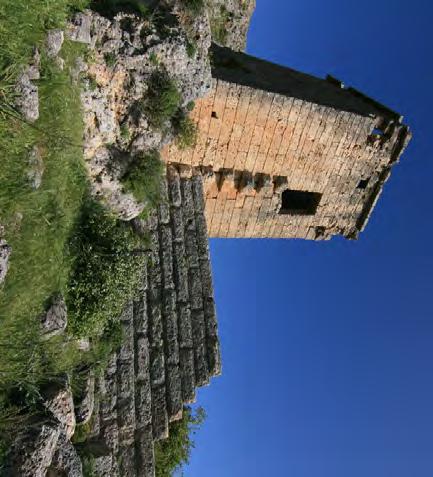
6 INTRODUCTION [A] Lower gate [B] Ramp [C] Bastions [D] Tower [E] Late Building [F] Hellenistic building [G] Building with Pamphylian inscription [H] Cistern [J] Theatre [K] Odeum [L] Upper Gate [M] Houses [N] Temple [0 1 ] Unidentified Building [0 2 ] Temple [P] Stadium [Q] Palace [R] Necropolis [S] Waterworks [T] Round Tower PLAN OF Sillyum (SOURCE: Bean G.E.)

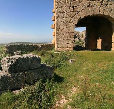
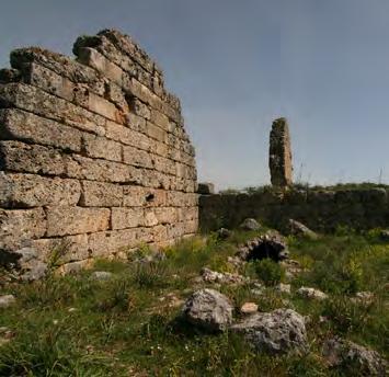
7 Sillyum seen from Asar Koyu (photo: Bean G.E.) INTRODUCTION
")
8 Water source near lower gate (photo: Argyraspid) INTRODUCTION
")
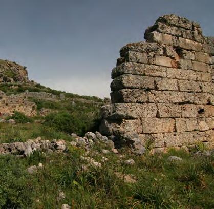
9 Theatre (photo: Argyraspid) INTRODUCTION

 (PHOTO:")
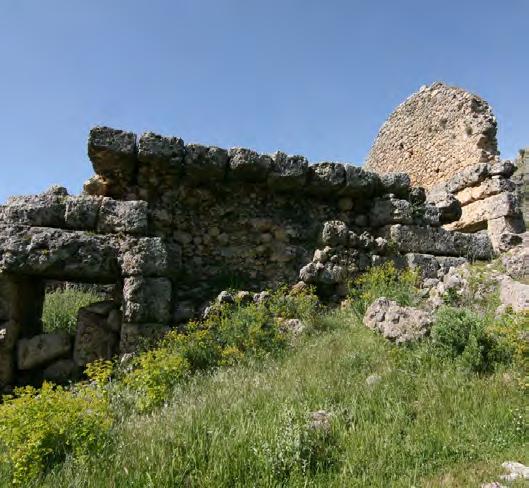
10 INTRODUCTION 3d scanned farm house (image: djaweb) (PHOTO: LEICA)

11 INTRODUCTION test with a local chapel URL:

12 INTRODUCTION test with a local chapel URL:


13 Exported pointcloud edited in Autocad INTRODUCTION

14 Le:Notre heritage group on the Sillyum site INTRODUCTION
 visual reference (image: Photosynth")
15 PHOTOGRAPHIC SURVEY ATTENTION POINTS: provide enough overlap between photos panorama first don t crop pictures shoot wide angle pictures limit the angle between photos move around the object shoot scenes with lots of detail and texture (source: photosynth blog) visual reference (image: Photosynth blog)


16 PHOTOGRAPHIC SURVEY PHOTO 099: TOWER FOTO 2: reutelbeek FOTO 3: Roeselarestraat PhOTO 239 TOWER Photo 359 tower SITE 1: tower


17 PHOTOGRAPHIC SURVEY PHOTO 059 PALACE PHOTO 290 PALACE FOTO 3: Roeselarestraat PhOTO 341 PALACE PHOTO 589 PALACe SITE 2: palace area
18 GENERATING THE POINT CLOUD USING PHOTOSYNTH PHOTOSYNTH: download from photosynth.net requires Silverlight NET requires a free Windows Live account reliable and fast broadband connection is needed reduce resolution size of photos prior to process & upload The easy to use interface of Photosynth

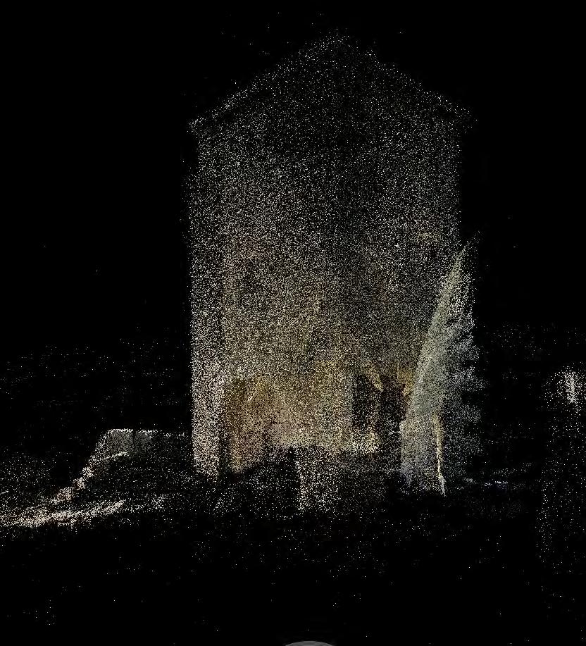
19 GENERATING THE POINT CLOUD USING PHOTOSYNTH the tower in the Photosynth browser URL:


20 GENERATING THE POINT CLOUD USING PHOTOSYNTH the PALACE area in THE Photosynth browser URL:

21 GENERATING THE POINT CLOUD USING PHOTOSYNTH Presentation (Photo: Ida Fasching)

22 further analysis using Autocad BROWSEPS: free AutoCAD Plugin requires NET Framework 3.5 SP1 command browseps stores a *.pcg file locally User interface of the browseps-plugin

23 further analysis using Autocad BROWSEPS: free export tool requires NET Framework 3.5 SP1 support for *.obj, *.ply, *vrml, and *.x3d User interface of SynthExport tool

24 further analysis using Autocad POINT CLOUD of the tower Classified by height

25 further analysis using Autocad POINT CLOUD of the tower Classified by height

26 further analysis using Autocad POINT CLOUD of the tower Classified by height

27 further analysis using Autocad orthogonal view of the tower & topography

28 further analysis using Autocad orthogonal view of both sides of the tower

29 further analysis using Autocad POINT CLOUD of the palace Classified by height


30 further analysis using Autocad TWO SECTIONS DERIVED FROM THE POINTCLOUD
31 CONCLUSIONS PRO: doesn t require expensive or heavy equipment easy to use fast results CON: far less accurate and detailed then a 3D laser scanner difficulties with repetitive patterns and complex occlusions Linux and Mac OS are unsupported Needs (fast) internet connection
32 Ruben JOYE - ruben.joye@hogent.be University College Ghent (Faculty School of Arts)
Generating a Point Cloud from a Crowdsourced Photographic Survey
 275 Generating a Point Cloud from a Crowdsourced Photographic Survey Ruben JOYE 1 Introduction The use of point cloud data a set of vertices in a three-dimensional coordinate system is becoming more and
Modelling. Ruth Aylett
 Modelling Ruth Aylett Overview Basic issues Modelling packages Low polygon modelling Importing models Buildings Photogrammetry Laser range finders LIDAR The great outdoors Cheap methods 3D Authoring tools
Modelling. Ruth Aylett
 Modelling Ruth Aylett Overview Basic issues Modelling packages Low polygon modelling Importing models Buildings Photogrammetry Laser range finders LIDAR The great outdoors Cheap methods 3D Authoring tools
insight3d quick tutorial
 insight3d quick tutorial What can it do? insight3d lets you create 3D models from photographs. You give it a series of photos of a real scene (e.g., of a building), it automatically matches them and then
USE THE 3D LASER SCANNING FOR DOCUMENTATION THE RIGA CATHEDRAL IN LATVIA
 USE THE 3D LASER SCANNING FOR DOCUMENTATION THE RIGA CATHEDRAL IN LATVIA Maris Kalinka, Elina Rutkovska, Department of Geomatic, Riga Technical University, Azenes 16-109, Riga, Latvia, geomatika@geomatika.lv
Overview. Modelling. 3D Authoring tools. Other VR Software Tools. 3D Modelling Tools. 3D Studio Max. Ruth Aylett
 Modelling Ruth Aylett Overview Basic issues Modelling packages Low polygon modelling Importing models City modelling Photogrammetry Laser range finders LIDAR The great outdoors Trees, plants, water etc
Hand-on introduction to 3D Digitisation Stephen Gray & Kirsty Merrett UoB Research Data Service
 Hand-on introduction to 3D Digitisation Stephen Gray & Kirsty Merrett UoB Research Data Service Plan Some basic information Laser scanning practical (in this room) Structured light scanning practical (in
There are a few things that some of you may be worried about, so here is a list of what Picasa will not do for those that may be concerned.
 Introduction to Picasa (MAC Guide) Picasa is an organising and editing program for images, provided by Google, which is free to download and install on your computer. It catalogues all the existing photographs
Gexcel. JRC 3D Reconstructor BASIC MEASURING TOOLS
 Gexcel JRC 3D Reconstructor BASIC MEASURING TOOLS In this tutorial you will learn how to Save snapshots of the 3D view Measure distances and angles of the 3D models Add annotations to the objects in the
PICASA3 DIGITAL IMAGE MANAGER/EDITOR
 PICASA3 DIGITAL IMAGE MANAGER/EDITOR Presentation 8 July 2010 by Mike Boesen for the PC Users Group mboesen@gmail.com 1 CONTEXT Photography is not my main focus: point and shoot for most images basic image
3D Modelling Creating Tool for Landscape Design: Camera
 78 Full Paper 3D Modelling Creating Tool for Landscape Design: Camera Ahmet Benliay 1, Isa Eren Akbiyik 2 1 Akdeniz University Faculty of Architecture, Landscape Architecture Department, Antalya/Turkey
EPOCHE 2013 LLP ERASMUS IP
 EPOCHE 2013 LLP ERASMUS IP Excellence in Photogrammetry for Open Cultural Landscape & Heritage Education Project Thesis of Group A THASSOS 2013 http://la.teikav.edu.gr/epoche/ Contents Section 1: Introduction
Modelling. Ruth Aylett
 Modelling Ruth Aylett Overview Basic issues Modelling packages Low polygon modelling Importing models City modelling Photogrammetry Laser range finders LIDAR The great outdoors Trees, plants, water etc
Rapid generation of 3D GIS content from reality capture data sources. Keir Keightley, HDR
 Rapid generation of 3D GIS content from reality capture data sources Keir Keightley, HDR Purpose Why do we want 3D GIS content? A picture is worth a thousand words, and more, if you can navigate it in
A Basic Guide to Modeling Landscapes in Google SketchUp
 DYNASCAPE SOFTWARE INC. A Basic Guide to Modeling Landscapes in Google SketchUp A DS Sketch 3D User Guide Volume 2 This guide will take you through the steps of creating a 3D model of a landscape in Google
3D BUILDINGS MODELLING BASED ON A COMBINATION OF TECHNIQUES AND METHODOLOGIES
 3D BUILDINGS MODELLING BASED ON A COMBINATION OF TECHNIQUES AND METHODOLOGIES Georgeta Pop (Manea), Alexander Bucksch, Ben Gorte Delft Technical University, Department of Earth Observation and Space Systems,
Speed, Accuracy and Performance at an Affordable Price
 Speed, Accuracy and Performance at an Affordable Price 012 2.A ions olut S 3D3 ed. serv s re ht ll rig VERSATILE for Industry Applications The HDI Advance 3D Scanner uses white light technology for capturing
OBJECT MANAGER PACKAGE USER S GUIDE
 OBJECT MANAGER PACKAGE USER S GUIDE 1 CONTENT I. Introduction... 3 II. Installation... 3 III. Using the plugins... 4 a- General... 4 b- Object properties manager... 4 c- Pipe manager... 6 d- Plane manager...
Children needing support to achieve key skills. Children surpassing key skills. Computing Progression in Skills Lower Key Stage Two
 Computing Progression in Skills Lower Key Stage Two Skills Year 3: Understanding Algorithms (programming, coding and control) Solve open ended problems with a floor robot, screen turtle and other programmable
Drones and Supercalculators : A New Field of Investigation in Photogrammetry.
 1 Drones and Supercalculators : A New Field of Investigation in Photogrammetry. The Rise in Popularity of Applications and Performances. Introduction... p. 2 Archeology... p. 3 National Heritage Sites
Mobile Applications and Time Management. Deanna Arbuckle, MRC, CRC University of Dayton
 Mobile Applications and Time Management Deanna Arbuckle, MRC, CRC University of Dayton darbuckle1@udayton.edu Session Description As students transition to college, they are faced with many changes. Not
TLS Parameters, Workflows and Field Methods
 TLS Parameters, Workflows and Field Methods Marianne Okal, UNAVCO GSA, September 23 rd, 2016 How a Lidar instrument works (Recap) Transmits laser signals and measures the reflected light to create 3D point
Visual Imaging in the Electronic Age Assignment #3 Draft Geometry Capture
 Visual Imaging in the Electronic Age Assignment #3 Draft Geometry Capture Assigned: October 5, 2017 Due Date: TBA (October 2017) The above image is of the sculpture by James Mahoney, which was demonstrated
Multi-factor Authentication Instructions
 What is MFA? Multi-factor Authentication (MFA) is a security measure to confirm your identity in addition to your username and password. It helps in the prevention of unauthorized access to your account.
RenWeb Training. Creating Your Classroom Website
 RenWeb Training Creating Your Classroom Website October 2013 RenWeb Training Manual Table of Contents Ren Web Survey 3 Pre-Training Handout: Saving a Document as a PDF 4 Lesson 1: Adding Homework & Web
The Institute of Remote Sensing and Digital Earth, Chinese Academy of Sciences liqi
 Fine Deformation Monitoring of Ancient Building Based on Terrestrial Laser Scanning Technologies The Institute of Remote Sensing and Digital Earth, Chinese Academy of Sciences liqi Outline Introduce the
FARO Laser Scanner Focus 3D X330 Demonstration Day
 FARO Laser Scanner Focus 3D X330 Demonstration Day Thursday 7 th November 2013 Precision Measurement Technology New Version SCENE 5.2 - Overview Support for Focus 3D X 330 SCENE WebShare Cloud Integration
Terrestrial 3D laser scanning Practical aspects
 Terrestrial 3D laser scanning Practical aspects ISPRS WG VI/5&SC Summer School 2007 by Gregor Bilban 3D laser scanning Benefits Lower data collection costs Reduction or elimination of re-visits More accurate
Welcome to MarkBookWeb : You re about to become acquainted with the finest classroom management program available today.
 QUICK START GUIDE INTRODUCTION Welcome to MarkBookWeb : You re about to become acquainted with the finest classroom management program available today. MarkBookWeb will work for you as a 1. Class Manager:
Intelligent photogrammetry. Agisoft
 Intelligent photogrammetry Agisoft Agisoft Metashape is a cutting edge software solution, with its engine core driving photogrammetry to its ultimate limits, while the whole system is designed to deliver
3D MESH RECONSTRUCTION USING PHOTOGRAMMETRY EX. 1 VISUAL SFM + MESHLAB. Afonso Maria C. F. A. Gonçalves
 3D MESH RECONSTRUCTION USING PHOTOGRAMMETRY EX. 1 VISUAL SFM + MESHLAB Afonso Maria C. F. A. Gonçalves 20130528 ADVANCED STUDIES PROGRAM IN COMPUTATION APPLIED TO ARCHITECTURE, URBAN PLANNING AND DESIGN
RenWeb Handout Manual
 RenWeb Handout Manual Tiffany Gurgel October 2013 RenWeb Handout Manual Table of Contents Pre-Training Handout: Creating a Document as a PDF 2 Handout 1A: Adding Homework & Web Document 4 Handout 2A: Creating
GIS in security planning of sport events
 The Council of European Geodetic Surveyors The CLGE Student Contest 2011-2012 GIS in security planning of sport events Author: Bálint Molnár (HUN) BSc student on Surveying and Land Management, University
Leica DISTO X3 Designed for tough, rugged conditions
 Leica DISTO X3 Designed for tough, rugged conditions The rugged Leica DISTO X-series combines innovative measuring technologies with a site-proof design and simple user interface. Together with the Leica
TLS Parameters, Workflows and Field Methods
 TLS Parameters, Workflows and Field Methods Marianne Okal, UNAVCO GSA, October 20 th, 2017 How a Lidar instrument works (Recap) Transmits laser signals and measures the reflected light to create 3D point
PhotoScan. Fully automated professional photogrammetric kit
 PhotoScan Fully automated professional photogrammetric kit Agisoft PhotoScan is a stand-alone photogrammetric software solution for automatic generation of dense point clouds, textured polygonal models,
3D Reconstruction of Ancient Structures Assisted by Terrestrial Laser Scanning Technology
 2nd International Forum on Management, Education and Information Technology Application (IFMEITA 2017) 3D Reconstruction of Ancient Structures Assisted by Terrestrial Laser Scanning Technology Li Xuefei
Setting up Flickr. Open a web browser such as Internet Explorer and type this url in the address bar.
 Workshop 15 th July 2008 Page 1 http://blog.larkin.net.au/ Setting up Flickr Flickr is a photo sharing tool that has rich functionality and allows the public to share their photographs with others., It
TLS Parameters, Workflows and Field Methods
 TLS Parameters, Workflows and Field Methods Marianne Okal, UNAVCO June 20 th, 2014 How a Lidar instrument works (Recap) Transmits laser signals and measures the reflected light to create 3D point clouds.
Integrating the Generations, FIG Working Week 2008,Stockholm, Sweden June 2008
 H. Murat Yilmaz, Aksaray University,Turkey Omer Mutluoglu, Selçuk University, Turkey Murat Yakar, Selçuk University,Turkey Cutting and filling volume calculation are important issues in many engineering
3D recording of archaeological excavation
 5 th International Conference Remote Sensing in Archaeology The Age of Sensing 13-15 October 2014 - Duke University 3D recording of archaeological excavation Stefano Campana UNIVERSITY of CAMBRIDGE Faculty
Leica DISTO S910 Measure point data and create plans
 Leica DISTO S910 Measure point data and create plans The world s first Measure anything from anywhere with P2P Technology It s been over 20 years since Leica Geosystems launched the first hand-held laser
Digitization of 3D Objects for Virtual Museum
 Digitization of 3D Objects for Virtual Museum Yi-Ping Hung 1, 2 and Chu-Song Chen 2 1 Department of Computer Science and Information Engineering National Taiwan University, Taipei, Taiwan 2 Institute of
INTEGRATING PHOTOGRAMMETRIC TECHNOLOGIES AND GEODETIC METHODS FOR 3D MODELING
 INTEGRATING PHOTOGRAMMETRIC TECHNOLOGIES AND GEODETIC METHODS FOR 3D MODELING Georgeta Pop Faculty of Geodesy, Geodesy and Photogrammetry Department, Technical University of Civil Engineering Bucharest,
Available online at ScienceDirect. Procedia Environmental Sciences 36 (2016 )
") Available online at www.sciencedirect.com ScienceDirect Procedia Environmental Sciences 36 (2016 ) 184 190 International Conference on Geographies of Health and Living in Cities: Making Cities Healthy
Available online at www.sciencedirect.com ScienceDirect Procedia Environmental Sciences 36 (2016 ) 184 190 International Conference on Geographies of Health and Living in Cities: Making Cities Healthy
3D Scanners help Grovely Wood speed up their production time
 Coventry St Michaels Cathedral, built in the late 14th century. It was one of the most beautiful and largest parish churches of its time, in England until it was destroyed during the Second World War.
WebShare Cloud Basics
 3D Laser Scanning WebShare Cloud Basics WebShare Cloud Instructions The purpose of this document is to walk you through the process of using WebShare Cloud if you have been invited to view information.
Photo Tourism: Exploring Photo Collections in 3D
 Click! Click! Oooo!! Click! Zoom click! Click! Some other camera noise!! Photo Tourism: Exploring Photo Collections in 3D Click! Click! Ahhh! Click! Click! Overview of Research at Microsoft, 2007 Jeremy
The Processing of Laser Scan Data for the Analysis of Historic Structures in Ireland
 The 7th International Symposium on Virtual Reality, Archaeology and Cultural Heritage VAST (2006) M. Ioannides, D. Arnold, F. Niccolucci, K. Mania (Editors) The Processing of Laser Scan Data for the Analysis
 Picasa 1 https://www.google.com/a/ww-p.org/ Enter your WW-P network ID and Password -> Sign In You will get the screen below. Please note that because K-12 education accounts are unable to utilize the
Virtual Bosnia and Herzegovina National Museum
 Virtual Bosnia and Herzegovina National Museum Edin Deljkic, Jana Jovicic, Nadir Badnjevic, Senad Biser Faculty of Electrical Engineering University of Sarajevo Sarajevo / Bosnia and Herzegovina Abstract
Multi-factor Authentication Instructions
 What is MFA? (MFA) is a security measure to confirm your identity in addition to your username and password. It helps in the prevention of unauthorized access to your account. MFA authentication is typically
Digital Photography - 1
 Digital Photography - 1 Taking Good Pictures How Film Cameras work How Digital Cameras work Digital Film (Memory Cards) Move Photos from Camera to Computer Organize Photos 1 Digital Cameras 2 Digital Cameras
Apps4.Pro Planner Manager Chrome Extension User Guide
 Apps4.Pro Planner Manager Chrome Extension User Guide Apps4.Pro Planner Manager extension is a web-based Chrome Extension application that can be installed and used on any operating systems (Windows, Mac,
Using Picasa Web Albums North Canton City Schools - Eric Curts
 Using Picasa Web Albums North Canton City Schools - Eric Curts Table of Contents: What is Picasa Web Albums? How to upload an image to Picasa web Albums How to manage an image you have added How to edit
Picasa for Mac Users. 1. Go to Click Download Picasa for Mac (Beta) to download Picasa. 2. You will see this screen:
 to download Picasa. 2. You will see this screen:") Picasa for Mac Users 1. Go to http://picasa.google.com/mac/. Click Download Picasa for Mac (Beta) to download Picasa. 2. You will see this screen: 3. You will see that Picasa has been downloaded in Downloads
Picasa for Mac Users 1. Go to http://picasa.google.com/mac/. Click Download Picasa for Mac (Beta) to download Picasa. 2. You will see this screen: 3. You will see that Picasa has been downloaded in Downloads
MFA (Multi-Factor Authentication) Enrollment Guide
 Enrollment Guide") MFA (Multi-Factor Authentication) Enrollment Guide Morristown Medical Center 1. Open Internet Explorer (Windows) or Safari (Mac) 2. Go to the URL: https://aka.ms/mfasetup enter your AHS email address and
MFA (Multi-Factor Authentication) Enrollment Guide Morristown Medical Center 1. Open Internet Explorer (Windows) or Safari (Mac) 2. Go to the URL: https://aka.ms/mfasetup enter your AHS email address and
GUIDE TO POST-PROCESSING OF THE POINT CLOUD
 GUIDE TO POST-PROCESSING OF THE POINT CLOUD Contents Contents 3 Reconstructing the point cloud with MeshLab 16 Reconstructing the point cloud with CloudCompare 2 Reconstructing the point cloud with MeshLab
AUDIENCE PARTICIPATION PORTION OF PROGRAM
 AUDIENCE PARTICIPATION PORTION OF PROGRAM PLEASE SET YOUR PHONES TO AIRPLANE MODE NOW OR TURN OFF PHONE S WI-FI HANDS-ON DEMO WON T BE POSSIBLE WITHOUT SUFFICIENT BANDWIDTH, WHICH IS VERY LIMITED IN THE
Using Panopto in Canvas
 Using Panopto in Canvas Panopto is a service that allows you to record and store video and audio ( podcasts ) recordings and link them to your Canvas courses. Panopto also supports live streaming of events.
ADVANCING REALITY MODELING WITH CONTEXTCAPTURE
 ADVANCING REALITY MODELING WITH CONTEXTCAPTURE Knowing the existing conditions of a project is a key asset in any decision process. Governments need to better know their territories, through mapping operations,
Digital Literacy Year Group e-safety/digital citizenship Digital Literacy
 Digital Literacy Year Group e-safety/digital citizenship Digital Literacy R 1 - Understand there is arrange of information on the internet Use a paint package to create a simple picture to - Navigate age
Watershed Sciences 4930 & 6920 ADVANCED GIS
 Watershed Sciences 4930 & 6920 ADVANCED GIS TERRESTRIAL LASER SCANNING (AKA GROUND BASED LIDAR) Joe Wheaton PURPOSE OF TODAY S DEMONSTRATION Introduce you to TLS Demystify TLS & LiDaR TODAY S PLAN I. What
Reality Modeling Webinar
 Reality Modeling Webinar Leveraging 3D Reality Meshes for Real-Time Asset Management and Monitoring What is Reality Modeling? Images & video? What is Reality Modeling? Images & video As-built drawings
User Documentation: Job Aid. SynerTrade Tendering/RFx. Supplier Quick Reference Guide
 User Documentation: Job Aid SynerTrade Tendering/RFx Supplier Quick Reference Guide 2016 Page 1 of 13 06/01/2016 Contents 1 FIRST STEPS... 4 1.1 General... 4 1.2 Login... 5 1.3 Maintain your profile and
Visual Guide to Online Campus
 Contents Course Navigation... 2 Avatars..3 Text Editor... 4 Accessing Assignments... 6 Accessing Assessments... 9 Accessing and Participating in Discussions... 12 Discussion Forums and Threads... 14 Creating
PhotoScan. Fully automated professional photogrammetric kit
 PhotoScan Fully automated professional photogrammetric kit Agisoft PhotoScan is a stand-alone photogrammetric software solution for automatic generation of dense point clouds, textured polygonal models,
Review Guide: Picasa 3 (beta) and Picasa Web Albums Fast and easy photo sharing from Google
 and Picasa Web Albums Fast and easy photo sharing from Google") Review Guide: Picasa 3 (beta) and Picasa Web Albums Fast and easy photo sharing from Google Together, Picasa and Picasa Web Albums make it easy for you to organize and edit your digital photos, and then
Review Guide: Picasa 3 (beta) and Picasa Web Albums Fast and easy photo sharing from Google Together, Picasa and Picasa Web Albums make it easy for you to organize and edit your digital photos, and then
Pointfuse V3.4 Quick Start
 Pointfuse V3.4 Quick Start Pointfuse quickly and accurately converts point clouds into intelligent mesh models with selectable surfaces for classification. You can directly upload models to Autodesk BIM
Using YouTube. ****Note: This document reflects PC instructions, but MAC would likely be similar.****
 Using YouTube ****Note: This document reflects PC instructions, but MAC would likely be similar.**** Signing Up: You ll need to do this ONCE. In order to upload files to YouTube, you must first sign up
Fire Dynamics Simulator
 Fire Dynamics Simulator Using FDS Find out more information about FDS at the primary FDS website FDS runs on Windows, Mac, and Linux. You can download FDS from the above website, or you can check out the
Design Conductor Training Document
 Design Conductor Training Document Design Conductor is a web based template library for all of your printed materials like brochures, newsletters, post cards and more. Authorized staff members will be
Create a movie project (using imovie app, version 211, on iphone 6)
") Create a movie project (using imovie app, version 211, on iphone 6) This is good to know before you get started: Undo or redo an action You can undo actions up until the last time you opened imovie. Just
Create a movie project (using imovie app, version 211, on iphone 6) This is good to know before you get started: Undo or redo an action You can undo actions up until the last time you opened imovie. Just
Create a Contact Sheet of Your Images Design a Picture Package Customize Your Picture Package Layout Resample Your Image...
 72 71 Create a Contact Sheet of Your Images................... 158 Design a Picture Package............ 160 73 Customize Your Picture Package Layout.... 162 74 Resample Your Image.................... 164
Part III: Survey of Internet technologies
 Part III: Survey of Internet technologies Content (e.g., HTML) kinds of objects we re moving around? References (e.g, URLs) how to talk about something not in hand? Protocols (e.g., HTTP) how do things
Fusion of laser scanning and Photogrammetric data for the documentation and VR visualization of an archaeological tomb complex
 Presented at the FIG Congress 2018, May 6-11, 2018 in Istanbul, Turkey Fusion of laser scanning and Photogrammetric data for the documentation and VR visualization of an archaeological tomb complex E.
The Transparent Classroom - 1
 The Transparent Classroom The Transparent Classroom The idea behind the transparent classroom is to leverage Web 2.0 tools to communicate with students and fellow faculty. This tutorial will introduce
Leica DISTO X4 Designed for bright, outdoor environments
 Leica DISTO X4 Designed for bright, outdoor environments Pointfinder camera The DISTO X4 is equipped with a Pointfinder camera allowing you to easily target distant objects in bright sunlight. Even if
Copyright
 Copyright NataliaS@portnov.com 1 Overview: Mobile APPS Categories Types Distribution/Installation/Logs Mobile Test Industry Standards Remote Device Access (RDA) Emulators Simulators Troubleshooting Guide
Point Cloud - Polygon Mesh. Wannes Van Isacker - Industrial Design 15
 Point Cloud - Polygon Mesh Wannes Van Isacker - Industrial Design 15 3D-SCANNING About 3D Scanning To get started with 3D scanning you first have to understand a little how the scanner works. The scanner
Marc De Bruyne 3D Design Improvement Leader, DOW Chemical
 Marc De Bruyne 3D Design Improvement Leader, DOW Chemical John Foster Director, Profox Companies DOW Chemical Terneuzen in the Netherlands Globally, second largest DOW site after Freeport US. Producing
High Definition Modeling of Calw, Badstrasse and its Google Earth Integration
 Master Thesis Yuanting LI High Definition Modeling of Calw, Badstrasse and its Google Earth Integration Duration of the Thesis: 6 months Completion: July, 2014 Supervisors: Prof.Dr.-Ing.Dieter Fritsch
Workshop. Dr. Denis Wohlfeld Innovation Manager P l a n t S i m u l a t i o n U s e r C o n f e r e n c e
 Workshop 3D Laser Scan PlantSimulation Dr. Denis Wohlfeld Innovation Manager 2 0 1 6 P l a n t S i m u l a t i o n U s e r C o n f e r e n c e GLOBAL FARO SITES W o r l d l e a d e r i n c o m p u t e
With FARO PointSense for Revit. Jörg Braunes Platform Owner Software Chris Palmer Sales Engineer 1
 From Point Clouds to BIM Models With FARO PointSense for Revit Jörg Braunes Platform Owner Software Chris Palmer Sales Engineer 1 Agenda Scan to BIM with Revit PointClouds in Revit Advanced Workflow with
MyBucks for Faculty and Staff
 MyBucks for Faculty and Staff MyBucks is the central area where college related information is located. Additionally, MyBucks provides access to the various college systems such as WebAdvisor, Datatel,
Drupal Basics. for COS and CLASS site maintainers
 Drupal Basics for COS and CLASS site maintainers Introduction This guide is meant as a starting point for site maintainers in the UNT College of Science and College of Liberal Arts and Social Sciences
TLS 1.2 Browser Compatibility
 TLS 1.2 Browser Due to security reasons, CUB Net banking site will be disabled on browser with SSL 1.0, SSL 2.0, SSL3.0 and TLS 1.0. The Net banking site will work on browsers with TLS 1.2 support. If
Pointfuse V3.4 Quick Start
 Pointfuse V3.4 Quick Start Pointfuse quickly and accurately converts point clouds into intelligent mesh models with selectable surfaces for classification. You can directly upload models to Autodesk BIM
TEACH UNICEF
 Online Educational Apps and Resources page 1 TEACH UNICEF http://www.teachunicef.org/topics 1. Select a topic from the options provided. 2. On the succeeding screen, you will find various teaching materials
Geotagging your images.
 Geotagging your images http://goo.gl/ybryr Where was this taken? Where was this taken? Why Geocode your images Organize images better, keep track of where you ve been Better way to show your images Remembers
Magento Photo Gallery Pro new Amasty extension
 Magento Photo Gallery Pro new Amasty extension Ksenia Dobreva Sep 4, 2014 Amasty team is ready to present another Magento extension! Please welcome: Photo Gallery Pro is at your service. Yes, we have released
Creating a Poster in Google SketchUp
 If you have digital image, or can find one online, you can easily make that image into a room poster. For this project, it helps to have some basic knowledge of Google SketchUp (though detailed instructions
Staff Directory & Online Classroom: A Picture Book
 Staff Directory & Online Classroom: A Picture Book eleventh in a series By Dennis Sulfsted Technology Coordinator Reading Community City Schools Holly Approved 2007 HRF Publications All current Picture
APPLICATIONS OF OPEN AND FREE SOFTWARE: FROM UNDERWATER TO THE SKY
 APPLICATIONS OF OPEN AND FREE SOFTWARE: FROM UNDERWATER TO THE SKY ISPRS Working Group V/2 Conference, Cultural heritage data acquisition and processing 17th 19th August 2011 - University of York, UK Why
ScanMaster Kit Manual
 ScanMaster Kit Manual Dear Scan Master Operator, We're excited you've chosen the new ScanMaster 3D Scanner. The ScanMaster 3D Scanner will allow you to capture the world around you. You can share your
COMPUTER VISION TOOLS FOR 3D MODELLING IN ARCHAEOLOGY
 1 COMPUTER VISION TOOLS FOR 3D MODELLING IN ARCHAEOLOGY M. Lo Brutto *, P. Meli Dept. of Civil, Environmental, Aerospace and Materials Engineering University of Palermo, Viale delle Scienze, 90128 Palermo,
How to install the squash bee survey app on your ANDROID device
 How to install the squash bee survey app on your ANDROID device Thank you for participating in the squash bee survey! We have several format options for taking the survey: smartphone app web browser Printable
Scanbot will now automatically try to capture the document. Please note that the scanning will work better if the document has a good contrast to the
 Scan bot Manual Scanning Press the big plus button on the start screen to start scanning. Now hold your device straight over a document, business card, receipt, QR code or bar code to scan. Scanbot will
Reality Capture using: RPAS Technologies & Image Laser Scanners
 Reality Capture using: RPAS Technologies & Image Laser Scanners by Johan Erasmus (RPAS Technologies) & Barend Bornman (Image Laser Scanners) from Aciel Geomatics Laser Scanners High-Definition Surveying
Equipment Guide. By Our Travel Passport
 Our Travel Passport Equipment Guide By Our Travel Passport We get a lot of questions about what equipment we use, so we created this equipment guide to share with you what camera gear we use and why! Cameras: