DYNAMIC MESSAGE SIGN MESSAGE DESIGN & DISPLAY MANUAL TRAINING Two-Day Course. Participant Notebook. for Texas Department of Transportation
|
|
|
- Anne Bishop
- 5 years ago
- Views:
Transcription
1 DYNAMIC MESSAGE SIGN MESSAGE DESIGN & DISPLAY MANUAL TRAINING Two-Day Course Participant Notebook for Texas Department of Transportation March 2009
2


3 Dynamic Message Sign Message Design & Display Manual Training Course Dynamic Message Signs (DMSs): Primary real-time links of TxDOT to the motoring public DMS Manual: pg DMSs Represent primary concept of ITS to public DMS Manual: pg DMS Message Design and Display Manual Training Page 1-1
4 DMSs Messages should be consistent with respect to: Content Format Application DMS Manual: pg DMS Message Design Process DMS operations require good understanding of: Traffic operations Human factors DMS Manual: pg Message Design Process DMS Manual: no page reference 1-6 DMS Message Design and Display Manual Training Page 1-2
5 Message Design Process Required message reading time Reading time available while approaching DMS DMS Manual: pg Message Design Process Required message reading time Reading time available while approaching DMS Distance traveled during time needed to read message Maximum distance at which message can first be read DMS Manual: pg There is a Maximum Message Length Affected by: Legibility distance of message Motorist perception, information processing capabilities DMS Manual: pg DMS Message Design and Display Manual Training Page 1-3
6 Available Message Viewing Distance Affected by: Type of DMS Sun position Geometric design Environmental conditions DMS Manual: pg Focus of Manual Design of effective messages for incidents & roadwork When & where to display messages Design of effective messages for: AMBER alert High water & floods Ozone Planned special events DMS Manual: pg DMS Near Incident/Roadwork DMS Manual: pg DMS Message Design and Display Manual Training Page 1-4
7 DMS Far From Incident/Roadwork DMS Manual: pg DMS on a Different Freeway DMS Manual: pg Manual Designed for: New users of DMSs Experienced users of DMSs At Entry level Experienced with traffic operations Managers DMS Manual: pg DMS Message Design and Display Manual Training Page 1-5
8
9 Principles of DMS Operations Module DMSs are used to manage traffic by displaying: Early warning messages DMS Manual: pg DMSs are used to manage traffic by displaying: Early warning messages Advisory messages DMS Manual: pg DMS Message Design and Display Manual Training Page 2-1
10 DMSs are used to manage traffic by displaying: Early warning messages Advisory messages Alternative routing messages DMS Manual: pg What Motorists Expect From DMSs Up-to-the-minute information DMS Manual: pg What Motorists Expect From DMSs Up-to-the-minute information Reliable information DMS Manual: pg DMS Message Design and Display Manual Training Page 2-2
11 What Motorists Expect From DMSs Up-to-the-minute information Reliable information Accurate information DMS Manual: pg What Motorists Expect From DMSs Up-to-the-minute information Reliable information Accurate information Relevant information DMS Manual: pg Credibility Is Critical! Never display specific traffic information before it is verified DMS Manual: pg DMS Message Design and Display Manual Training Page 2-3

12 How Is Credibility Damaged? By displaying messages that are: Inaccurate RT LANE CLOSED AHEAD DMS Manual: pg How Is Credibility Damaged? By displaying messages that are: Inaccurate Not current ACCIDENT 1 MILE DMS Manual: pg How Is Credibility Damaged? By displaying messages that are: Inaccurate Not current Irrelevant DMS Manual: pg DMS Message Design and Display Manual Training Page 2-4
13 How Is Credibility Damaged? By displaying messages that are: Inaccurate Not current Irrelevant Obvious CAUTION CONGESTION AHEAD DMS Manual: pg How Is Credibility Damaged? By displaying messages that are: Inaccurate Not current Irrelevant Obvious Trivial EXPECT 1 MIN DELAY AHEAD DMS Manual: pg How Is Credibility Damaged? By displaying messages that are: Inaccurate Not current Irrelevant Obvious Trivial Incorrect (especially numbers) DMS Manual: pg DMS Message Design and Display Manual Training Page 2-5
14 DMS Manual: no page reference 2-16 DMS Manual: no page reference 2-17 DMS Message Design and Display Manual Training Page 2-6
15 DMS Operating Fundamentals Module 3 DMS Operating Fundamentals Continuously changing information Determine the purpose of using a DMS Determine which DMS is (are) appropriate Determine what to display on the DMS Determine how long to display the message Resolve any message signing conflicts that exist DMS Manual: pg Determine Purpose What is the problem I am trying to address? Type of problem Location of problem Scope (e.g., number of lanes blocked, minor or major) Potential duration Extent of impacts DMS Manual: pg DMS Message Design and Display Manual Training Page 3-1
16 Determine Purpose What verified information do I have? Incident Conditions on primary route Conditions on diversion route DMS Manual: pg Determine Purpose Who is the audience for the DMS message? All users of the freeway Select group DMS Manual: pg Determine Purpose What type of driver response is desired? Reduce speed Move out of blocked/closed lane Take another route DMS Manual: pg DMS Message Design and Display Manual Training Page 3-2
17 Determine Purpose What type of driver response is desired? Reduce speed Move out of blocked/closed lane Take another route Effective messages encourage driver response DMS Manual: pg Determine Purpose Where should the response take place? Type of response desired Layout of the roadway system Type and severity of problem Existing guidance along alternative route DMS Manual: pg Determine Purpose What degree of response is desired? Keep message displayed for more response Turn message off for less response DMS Manual: pg DMS Message Design and Display Manual Training Page 3-3
18 Determine Appropriate DMSs Proximity of DMSs to problem Questions: Expected problem longer than expected travel time? Significant number of motorists passing sign? DMS Manual: pg Determine Appropriate DMSs Characteristics of DMS hardware Type of sign Number of lines Number of characters per line Need to move portable signs in place Relationship to info on static signs DMS Manual: pg Determine Appropriate DMSs External Influences Traffic speed Vertical/ horizontal curves Sun position Guide signs Rain or fog DMS Manual: pg DMS Message Design and Display Manual Training Page 3-4
19 Determine What to Display Base information needs and DMS message Type of problem Location of problem Lanes affected Location of lane closure Effect on Travel DMS Manual: pg Determine What to Display Base information needs and DMS message Audience for message Proper response or driving action by motorist Reason to follow recommended driving action DMS Manual: pg Determine What to Display On diversion routes, operator must know: Current traffic conditions Current traffic capacity constraints Guide sign information DMS Manual: pg DMS Message Design and Display Manual Training Page 3-5
20 Determine Duration of Display Off-peak May be desirable to turn message off by hand DMS Manual: pg Determine Duration of Display Off-peak May be desirable to turn message off manually once no longer needed Peak May be desirable to estimate duration and have system turn message off automatically DMS Manual: pg Resolve Signing Conflicts Most common types of conflicts: Two events on same freeway One event on freeway and second on intersecting freeway One event on freeway and second on connecting freeway in adjacent state DMS Manual: pg DMS Message Design and Display Manual Training Page 3-6
21 Resolve Signing Conflicts Most common types of conflicts: Two events on intersecting freeway One event on an intersecting freeway and a second on a connecting freeway in an adjacent state DMS Manual: pg DMS Message Design and Display Manual Training Page 3-7
22
23 Principles of DMS Message Design Module 4 PART 1 Overview of Issues DMS Manual: pg Overview of DMS Issues Direct link with motoring public Effective Messages Poorly Designed Message DMS Manual: pg DMS Message Design and Display Manual Training Page 4-1

24 Overview of DMS Issues Direct link with motoring public Messages must be standard and consistent DMS Manual: pg Overview of DMS Issues Direct link with motoring public Messages must be standard and consistent Only few seconds to communicate message DMS Manual: pg Overview of DMS Issues Message length controlled by exposure time DMS Manual: pg DMS Message Design and Display Manual Training Page 4-2
25 Overview of DMS Issues Message length controlled by exposure time Some needed information must be omitted DMS Manual: pg Overview of DMS Issues Message length controlled by exposure time Some needed information must be omitted Motorist understanding must be enhanced DMS Manual: pg PART 2 Selecting an Audience DMS Manual: pg DMS Message Design and Display Manual Training Page 4-3
26 Audience for Message Why is it necessary to think about the audience of the message? DMS Manual: pg Audience for Message Unfamiliar Motorists Will Have Difficulty Understanding: Local street and highway names Abbreviations for local landmarks, bridges, entertainment and recreational facilities = longer message processing times DMS Manual: pg PART 3 Definitions and Message Design Considerations DMS Manual: pg DMS Message Design and Display Manual Training Page 4-4
27 Message Design Considerations Content: specific information displayed Length: number of words or characters Load: number of units of information Info Unit: answer to a motorist question Format: order of information units DMS Manual: pg Message Content Motorists want to know: What is wrong ahead Where What to do Reason to follow advice DMS Manual: pg Message Length Constraints: Message must fit on DMS Maximum length controlled dby reading time Motorist time shares reading & driving task Motorist must read entire DMS message Message familiarity enhances reading time Reading time longer if unfamiliar Reading time shorter if familiar DMS Manual: pg DMS Message Design and Display Manual Training Page 4-5
28 Message Length 8 word maximum at 55 mph 7 word maximum at 65 mph What if the message is longer than this? DMS Manual: pg Message Length 8 word maximum at 55 mph 7 word maximum at 65 mph If too long, motorists may reduce speed We should always try to minimize the length of the message DMS Manual: pg Message Load and Info Unit Info Question Answer Unit 1. What happened? ACCIDENT 1 Unit 2. Where? PAST ROWLAND 1 Unit 3. Who is advisory for? FAIR PARK 1 Unit 4. What is advised? USE FITZHUGH 1 Unit 4 Units DMS Manual: pg DMS Message Design and Display Manual Training Page 4-6
29 Message Load and Info Units Information Units for Entire Message: No more than 4 units for speeds 35 mph No more than 5 units for speeds < 35 mph Information Units in a Message Phase: No more than 3 units Information Units on a Line: No more than 2 units DMS Manual: pg Message Format Must place Information Units in the proper order to: Enhance motorist expectations Reduce reading time Enhance understanding DMS Manual: pg PART 4 Base DMS Message DMS Manual: pg DMS Message Design and Display Manual Training Page 4-7
30 Base DMS Message The Base DMS Message: Sum total of allinformation motorists want to have Will normally exceed the maximum number of information units Must normally be reduced in length DMS Manual: pg Base DMS Message The Base DMS Message Elements Incident/Roadwork Descriptor Incident/Roadwork Location Lanes Affected (Closure Descriptor) (Location of Closure) DMS Manual: pg Base DMS Message The Base DMS Message Elements (cont d) Effect on Travel Audience for Action Action One Good Reason for Following Action DMS Manual: pg DMS Message Design and Display Manual Training Page 4-8
31 Descriptor Element Descriptor element informs motorists of the unusual situation DMS Manual: pg Location Element Location element informs motorists of the location of unusual situation Must follow the Descriptor No need for route number or name if on same freeway DMS Manual: pg Location Element For commuters: Reference to street names, exit names or numbers, landmarks For unfamiliar motorists: Reference by distance, exit numbers DMS Manual: pg DMS Message Design and Display Manual Training Page 4-9
32 Location Element Preferred by Familiar or Unfamiliar Drivers? familiar unfamiliar both familiar and unfamiliar ACCIDENT AT ROWLAND ACCIDENT 1 MILE ACCIDENT AT EXIT 12 DMS Manual: pg Location Element Subtle differences in location terms can be important Near At Before Past From Between DMS Manual: no page number 4-29 DMS Manual: no page number 4-30 DMS Message Design and Display Manual Training Page 4-10

33 DMS Manual: no page number 4-31 DMS Manual: no page number 4-32 DMS Manual: no page number 4-33 DMS Message Design and Display Manual Training Page 4-11

34 DMS Manual: no page number 4-34 Lanes Affected Element Lanes Affected element gives specific info about which lanes or exit ramps are closed or blocked Helps motorists prepare to change to open lanes or use another ramp DMS Manual: pg Closure Descriptor Element Closure Descriptor element used in place of Incident/Roadwork Descriptor when all lanes are closed DMS Manual: pg DMS Message Design and Display Manual Training Page 4-12
35 Effect on Travel Element Effect on Travel element informs motorist of severity of problem Helps motorist make informed diversion decisions Can imply expected arrival time DMS Manual: pg Effect on Travel Element Delay (number) MIN DELAY AVOID (number) MIN DELAY SAVE (number) MIN DMS Manual: pg Effect on Travel Element Travel Time Motorists can measure and refute Speed sensors large errors in congested conditions DMS Manual: pg DMS Message Design and Display Manual Training Page 4-13
36 Audience for Action Element Audience for Action element used only when the Action applies to a specific group of motorists Thus, must always be accompanied by an Action message element DMS Manual: pg Audience for Action Element The word TRAFFIC with a destination is not generallyused. Thereisone exception DMS Manual: pg Action Element Action element is necessary because it tells motorists what to do It is best that every incident management message have an Action statement DMS Manual: pg DMS Message Design and Display Manual Training Page 4-14
37 Good Reason Element Motorists must be confident that he/she is taking the best course of action In most cases, the Good Reason is implied DMS Manual: pg PART 5 Word and Word Phrase Meanings and Criteria Cit i DMS Manual: pg Word Meanings & Criteria USE Route that will take motorists to destination TAKE Directive to begin first leg of route FOLLOW Motorist will be guided by other signs EXIT Sometimes used as a verb GO Not used DMS Manual: pg DMS Message Design and Display Manual Training Page 4-15
38 Word Meanings & Criteria ROADWORK shorter than CONSTRUCTION EXIT when referring to an off ramp on freeway RAMP when referring to an on ramp NITE shorter than NIGHT FOR 1 WEEK Mon through Fri WEEKEND Sat AM to Sun PM DMS Manual: pg Advance Notification Messages Use dates only when necessary Use text/number format (i.e., JUN 12) Do not repeat month abbreviation (i.e., JUN 12 15) Avoid day/date/time messages because it far exceeds information load limits DMS Manual: pg 4 17 and TTI Report PART 6 Diversion/Detour Route Descriptors DMS Manual: pg DMS Message Design and Display Manual Training Page 4-16
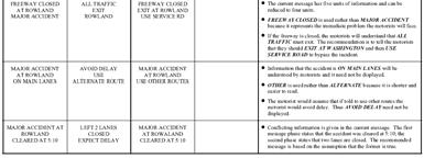
39 Route Characteristic Differences Presence of electronic or human surveillance Existing guide signs or trailblazers to freeway Police and/or traffic control personnel at critical decision points Incident emergency route plan signing Roadwork traffic control plan (temporary traffic control devices present) See Tables 4.1 and 4.2 (p. 4 22) DMS Manual: pg PART 7 Dynamic Features on DMSs DMS Manual: pg Dynamic Features on DMSs AVOID flashing an entire onephase message MAJOR ACCIDENT AT ROWLAND LEFT 2 LANES CLOSED DMS Manual: pg DMS Message Design and Display Manual Training Page 4-17
40 Dynamic Features on DMSs AVOID flashing one line of a one phase message MAJOR ACCIDENT AT ROWLAND LEFT 2 LANES CLOSED DMS Manual: pg Dynamic Features on DMSs AVOID alternating text MAJOR ACCIDENT AT ROWLAND LEFT 2 LANES CLOSED DMS Manual: pg Dynamic Features on DMSs AVOID alternating text MAJOR ACCIDENT AT ROWLAND TUNE TO 530 AM DMS Manual: pg DMS Message Design and Display Manual Training Page 4-18


41 Designing Base Message: Incidents and Roadwork Modules 5 & 6 Base Message Elements Incident/Roadwork Descriptor Incident/Roadwork Location Lanes Closed Effect on Travel Audience for Action Action Good Reason for Following Action DMS Manual: pg 5-1 & 6-1 5&6-2 Lane Closures: DMS Close to Incident/Roadwork DMS Manual: pg 5-2 & 6-2 5&6-3 DMS Message Design and Display Manual Training Page 5&6-1
42 Incident/Roadwork Descriptor DMS Manual: pg 5-2 & 6-2 5&6-4 Incident/Roadwork Location DMS Manual: pg 5-3 & 6-3 5&6-5 Lanes Closed DMS Manual: pg 5-4 & 6-4 5&6-6 DMS Message Design and Display Manual Training Page 5&6-2
43 Effect on Travel DMS Manual: pg 5-5 & 6-5 5&6-7 Action Motorists are not advised to take an alternative route: No diversion DMS Manual: pg 5-6 & 6-6 5&6-8 Action soft diversion DMS Manual: pg 5-7 & 6-7 5&6-9 DMS Message Design and Display Manual Training Page 5&6-3
44 Action Motorists are advised to take a specific Type 2 diversion route DMS Manual: pg 5-8 & 6-8 5&6-10 Audience for Action DMS Manual: pg 5-9 & 6-9 5&6-11 Good Reason for Following Action DMS Manual: pg 5-10 & &6-12 DMS Message Design and Display Manual Training Page 5&6-4

45 DMS Far From Incident/Roadwork Tables differ slightly for Lanes Closed DMS Manual: pg 5-4 & &6-13 DMS on Different Freeway Tables different for Incident Location DMS Manual: pg 5-3 & &6-14 DMS on Different Freeway Tables different for Action: No Diversion DMS Manual: pg 5-6 & &6-15 DMS Message Design and Display Manual Training Page 5&6-5


46 Total Freeway or Ramp Closures DMS Manual: pg 5-30 & &6-16 Action: with diversion DMS Manual: pg &6-17 Action: with diversion DMS Manual: pg &6-18 DMS Message Design and Display Manual Training Page 5&6-6
47 Establishing the Maximum Message Length Module 7 PART 1 Message Length and DMS Viewing Distance Requirements DMS Manual: pg Required Viewing Distances to DMS For a given number of info units: Higher speeds require higher, legibility distances stance Required Viewing Dis (ft) Number of Units of Information 35 mph 55 mph 65 mph 75 mph DMS Manual: pg DMS Operations Manual Training Page 7-1
 300")


48 Sight Distance for Lateral Offset Longer lateral distances require more legibility distance 400 ance Additional Sight Dista Required (ft) Offset Between Motorist and VMS (ft) DMS Manual: pg Factors Reducing Legibility Distance to a DMS Lighting Conditions DMS Manual: pg Factors Reducing Legibility Distance to a DMS Sun Position DMS Manual: pg DMS Operations Manual Training Page 7-2

49 Factors Reducing Legibility Distance to a DMS Vertical & Horizontal Curvature DMS Manual: pg Factors Reducing Legibility Distance to a DMS Spot obstructions DMS Manual: pg Rain or fog Factors Reducing Legibility Distance to a DMS DMS Manual: pg DMS Operations Manual Training Page 7-3
50 Factors Reducing Legibility Distance to a DMS Trucks in the traffic stream DMS Manual: pg Therefore, Maximum allowable number of units of information may have to be REDUCED DMS Manual: pg PART 2 Maximum Legibility Distances for Day & Night Operations DMS Manual: pg DMS Operations Manual Training Page 7-4

51 Suggested legibility distances Day & Night DMS Manual: pg Maximum number of units of info Day & Night DMS Manual: pg Reduce Units for Vertical Curves Only necessary in very extreme cases DMS Manual: pg DMS Operations Manual Training Page 7-5
52 Reduce Units for Horizontal Curves (Necessary only in extreme cases) DMS Manual: pg Reduce Units for Horizontal Curves (Necessary only in extreme cases) DMS Manual: pg Reduce Units for Rain Generally rain is insignificant As a rule, use maximum values in Table 7.2 Exception: rainfall over 2 inches per hour Reduce units of info in Table 7.2 by 1 DMS Manual: pg DMS Operations Manual Training Page 7-6
53 Reduce Units for Fog DMS Manual: pg Reduce Units for Large Trucks DMS Manual: pg DMS Operations Manual Training Page 7-7
54


55 Dealing with Long Messages Module 8 PART 1 Splitting Messages DMS Manual: pg Principles No more than two frames should be used DMS Manual: pg DMS Message Design and Display Manual Training Page 8-1
56 Principles Each frame must be understood by itself Acceptable Unacceptable DMS Manual: pg Principles Compatible units of information should be displayed on the same frame Acceptable Unacceptable DMS Manual: pg Principles A message line should not contain portions of two different units of info Acceptable Unacceptable DMS Manual: pg DMS Message Design and Display Manual Training Page 8-2
57 Principles Limit of 3 units of info on a single frame at high speeds Acceptable Unacceptable BEST ROUTE TO DALLAS USE I-30 I-45 CLOSED AT SMITH ST USE I-30 TO I-35E DMS Manual: pg 8-4 (example is different than in manual) 8-7 PART 2 Approaches to Reducing Message Length DMS Manual: pg Reducing Message Length Delete Dead Words Formatting Messages Using Abbreviations DMS Manual: pg DMS Message Design and Display Manual Training Page 8-3
58 Delete Dead Words Street, Avenue, Boulevard Ahead DMS Manual: pg Formatting Messages Order of information units dependent upon whether Incident/Roadwork Descriptor message element is: Part of message, or Replaced by or combined with Lanes Closed message element DMS Manual: pg Formatting Messages Messages with Incident Descriptor (One Frame) DMS Manual: pg DMS Message Design and Display Manual Training Page 8-4
59 Formatting Messages Messages with Incident Descriptor (Two Frames) DMS Manual: pg Formatting Messages Similar tables are available for Messages with Roadwork Descriptor Messages without Incident Descriptor Messages without Roadwork Descriptor DMS Manual: pg 8-7 through Acceptable Using Abbreviations DMS Manual: pg DMS Message Design and Display Manual Training Page 8-5
60 Using Abbreviations Unacceptable Terms DMS Manual: pg PART 3 Reducing Message Units of Information DMS Manual: pg Reformatting Units of information can be reduced by: Omitting unimportant words Omitting redundant information Combining Base DMS Message elements DMS Manual: pg DMS Message Design and Display Manual Training Page 8-6

61 DMS Manual: pg PART 4 Reducing Units of Info from Base Message DMS Manual: pg Reducing Base Message Units Reduce the number of units of info in the Base DMS Message by: Applying Initial Reduction Approaches Then Secondary Reduction Approaches using Priority Reduction Principles DMS Manual: pg DMS Message Design and Display Manual Training Page 8-7
62 Initial Reduction Approaches Reducing Redundancy in Incident/ Roadwork Messages Omit reference to same freeway DMS Manual: pg Initial Reduction Approaches Combining Message Elements for Incident Messages Combine Incident Descriptor, Location, Lanes Affected elements DMS Manual: pg Initial Reduction Approaches DMS Manual: pg DMS Message Design and Display Manual Training Page 8-8
63 Initial Reduction Approaches Combine Location of Closure and Action message elements DMS Manual: pg Initial Reduction Approaches Combining/Replacing Message Elements for Roadwork Messages Combine/Replace Roadwork Descriptor with Lanes Closed elements DMS Manual: pg Initial Reduction Approaches DMS Manual: pg DMS Message Design and Display Manual Training Page 8-9
64 Initial Reduction Approaches Combine Roadwork Descriptor, Location and Lanes Closed message elements DMS Manual: pg Initial Reduction Approaches Combining Location of Closure and Action message elements DMS Manual: pg Secondary Reduction Approaches Reducing Number of Destinations in Action Message Element DMS Manual: pg DMS Message Design and Display Manual Training Page 8-10
65 Priority Reduction Principles DMS Manual: pg DMS Message Design and Display Manual Training Page 8-11
66


67 Designing Messages for Incidents and Roadwork Modules 9 & 10 Procedure for Incidents PART 1: Lane closure (blockage) incidents PART 2: Incidents that require closing the freeway PART 3: Incidents on intersecting freeway that require closing the connector ramp DMS Manual: pg 9-i &10-i 9&10-2 Procedure for Incidents In each PART: DMS on same freeway and relatively close to the incident DMS on same freeway but relatively far from incident DMS on different freeway than incident DMS Manual: pg 9-i &10-i 9&10-3 DMS Message Design and Display Manual Training Page 9&10-1
68 Procedure for Incidents Lane Closure (Blockage) 1. Establish initial maximum allowable number of units of information based on DMS type and operating speeds DMS Manual: pg 9-1 9&10-4 Procedure for Incidents Lane Closure (Blockage) 1. Establish initial maximum allowable number of units of information based on DMS type and operating speeds 2. Assess whether the message must be reduced because of local geometric sight distance restrictions to the DMS DMS Manual: pg 9-1 9&10-5 Procedure for Incidents Lane Closure (Blockage) 3. Assess whether the message must be reduced because of local environmental sight distance restrictions to the DMS such as of rain or fog DMS Manual: pg 9-2 9&10-6 DMS Message Design and Display Manual Training Page 9&10-2
69 Procedure for Incidents Lane Closure (Blockage) 3. Assess whether the message must be reduced because of local environmental sight distance restrictions to the DMS because of rain or fog 4. Finalize the maximum allowable units of information in the message DMS Manual: pg 9-2 9&10-7 Procedure for Incidents Lane Closure (Blockage) 5. Define the Base DMS Message to satisfy motorist information needs DMS Manual: pg 9-2 9&10-8 Procedure for Incidents Lane Closure (Blockage) 5. Define the Base DMS Message to satisfy motorist information needs 6. Reduce the number of message units if necessary DMS Manual: pg 9-4 9&10-9 DMS Message Design and Display Manual Training Page 9&10-3
70 Procedure for Incidents Lane Closure (Blockage) 5. Define the Base DMS Message to satisfy motorist information needs 6. Reduce the number of message units if necessary 7. Format the message DMS Manual: pg 9-5 9&10-10 Procedure for Incidents Lane Closure (Blockage) 8. Adjust message to fit on existing DMS DMS Manual: pg 9-5 9&10-11 Procedure for Incidents Lane Closure (Blockage) 8. Adjust message to fit on existing DMS 9. Adjust message to fit on 3 lines or less DMS Manual: pg 9-5 9&10-12 DMS Message Design and Display Manual Training Page 9&10-4
71 Procedure for Incidents Lane Closure (Blockage) 8. Adjust message to fit on existing DMS 9. Adjust message to fit on 3 lines or less 10. Finalize DMS message DMS Manual: pg 9-6 9&10-13 Procedure for Incidents Detailed step-by-step procedure Refers user to tables in Module 7: Establishing Maximum Message Length DMS Manual: pg 7-1 9&10-14 Procedure for Incidents Detailed step-by-step procedure Refers user to tables in Module 7: Establishing Maximum Message Length Module 5: Designing the Base DMS Message for Incidents For roadwork messages, tables in Module 6 would be used instead DMS Manual: pg 7-1, 5-1, & 6-1 9&10-15 DMS Message Design and Display Manual Training Page 9&10-5
72
73 Modifying Messages to Improve Effectiveness Module 12 Improving Message Effectiveness DMS Manual: pg Improving Message Effectiveness DMS Manual: pg DMS Message Design and Display Manual Training Page 12-1


74 Improving Message Effectiveness DMS Manual: pg Improving Message Effectiveness DMS Manual: pg Improving Message Effectiveness DMS Manual: pg DMS Message Design and Display Manual Training Page 12-2
75 Message Design Example - Incident: Large DMS Module 14 All Lanes Closed DMS Manual: pg All Lanes Closed Define Situation Analyze Incident and Incident Scene Characteristics DMS Manual: pg DMS Message Design and Display Manual Training Page 14-1
76 All Lanes Closed Design Message for DMS on Same Freeway Relatively Close to Incident DMS #1 DMS Manual: pg DMS #1: All Lanes Closed Identify DMS Characteristics DMS Manual: pg DMS #1: All Lanes Closed Identify DMS Characteristics Review Conditions at DMS Location DMS Manual: pg DMS Message Design and Display Manual Training Page 14-2
77 DMS #1: All Lanes Closed Identify DMS Characteristics Review Conditions at DMS Location Identify Diversion Route Characteristics DMS Manual: pg DMS #1: All Lanes Closed DMS Manual: pg 14-2 & DMS #1: All Lanes Closed Identify DMS Characteristics Review Conditions at DMS Location Identify Diversion Route Characteristics Set Objectives DMS Manual: pg DMS Message Design and Display Manual Training Page 14-3
78 DMS #1: All Lanes Closed Establish Initial Maximum Allowable Number of Units of Info in the Message Based on DMS Type and Freeway Operating Speeds DMS Manual: pg DMS #1: All Lanes Closed Step 1 Determine Freeway Operating Speed at the DMS Location. Freeway speed is 30 mph DMS Manual: pg DMS #1: All Lanes Closed Step 2 Determine the Initial Maximum Allowable Number of Units of Information in the Message from Table 7.2, page 7-4. Based on sun position, max allowable of 5 units DMS Manual: pg DMS Message Design and Display Manual Training Page 14-4
79 Assess Whether the Message Must Be Reduced Because of Local Geometric Sight Distance Restrictions to DMS DMS Manual: pg DMS #1: All Lanes Closed Step 3 Determine Whether There are Sight Distance Restrictions to the DMS Because of a Vertical Curve Using the Guidelines in Section UNITS OF INFORMATION REDUCTIONS FOR VERTICAL CURVES on page 7-6 No reductions in max of 5 units Go to Step 5 DMS Manual: pg DMS #1: All Lanes Closed Step 5 Determine Whether There are Sight Distance Restrictions to the DMS Because of a Horizontal Curve Using the Guidelines in Section UNITS OF INFORMATION REDUCTIONS FOR HORIZONTAL CURVES on page 7-10 No reductions in max of 5 units Go to Step 7 DMS Manual: pg DMS Message Design and Display Manual Training Page 14-5
80 Assess Whether the Message Must Be Reduced Because of Environmental Sight Distance Restrictions to DMS (Rain/Fog) DMS Manual: pg DMS #1: All Lanes Closed Step 7 Determine Whether Rainfall near the DMS Exceeds 2 Inches per Hour No. No reductions in max of 5 units Go to Step 9 DMS Manual: pg DMS #1: All Lanes Closed Step 9 Determine Whether Fog Exists near the DMS No. No reductions in max of 5 units Go to Step 11 DMS Manual: pg DMS Message Design and Display Manual Training Page 14-6
81 Finalize the Maximum Allowable Units of Information in the Message DMS Manual: pg DMS #1: All Lanes Closed Step 11 Based on Steps 1 through 10, Finalize the Maximum Allowable Number of Units of Information in the Message No reductions in max of 5 units DMS Manual: pg Define Base DMS Message to Satisfy Motorist Information Needs DMS Manual: pg DMS Message Design and Display Manual Training Page 14-7
82 DMS #1: All Lanes Closed Step 12 Select Incident Descriptor Message Element from Table 5.28, page 5-31 Incident Descriptor: MAJOR ACCIDENT DMS Manual: pg DMS #1: All Lanes Closed Step 13 Select Incident Location Message Element from Table 5.29, page 5-32 Location: PAST I-22 DMS Manual: pg DMS #1: All Lanes Closed Step 14 Select Lanes Closed Message Element from Table 5.30, page 5-33 Lanes Closed: ALL LANES CLOSED DMS Manual: pg DMS Message Design and Display Manual Training Page 14-8
83 DMS #1: All Lanes Closed Step 15 Select Closure Location Message Element from Table 5.31, page 5-34 Closure Location: AT I-22 DMS Manual: pg DMS #1: All Lanes Closed Step 16 Determine Whether Diversion Traffic Control is in Place Yes. Go to Step 20 DMS Manual: pg DMS #1: All Lanes Closed Step 20 Select Type 5 Diversion (Detour) Route Action Message Element from Table 5.35, page 5-38 Action: EXIT AT I-22 FOLLOW DETOUR DMS Manual: pg DMS Message Design and Display Manual Training Page 14-9
84 DMS #1: All Lanes Closed Step 21 Establish Whether Action Message Is for a Select Group of Motorists No. Go to Step 23 DMS Manual: pg DMS #1: All Lanes Closed Step 23 Examine Whether the Diversion Route May Be Perceived by Motorists as Being a Most Logical Route Yes. Go to Step 25 DMS Manual: pg DMS #1: All Lanes Closed Summary Incident Descriptor: MAJOR ACCIDENT Location: PAST I-22 Lanes Closed: ALL LANES CLOSED Closure Location: AT I-22 Action: EXIT AT I-22 FOLLOW DETOUR 6 Units of Information DMS Manual: pg DMS Message Design and Display Manual Training Page 14-10
85 Reduce the Number of Message Units If Necessary DMS Manual: pg DMS #1: All Lanes Closed Step 25 Examine Whether the Number of Units of Information Units in the Base DMS Message Is Greater than the Maximum Allowable from Step 11 Yes. Base DMS Message = 6 units Maximum Allowable = 5 units Continue to Step 26 DMS Manual: pg DMS #1: All Lanes Closed Step 26 Omit Incident Descriptor Message Element According to Guidelines in the Section on Combining Message Elements for Incident Messages Beginning i on page 8-15 FREEWAY CLOSED EXIT AT I-22 FOLLOW DETOUR 3 Units of Information DMS Manual: pg DMS Message Design and Display Manual Training Page 14-11
86 DMS #1: All Lanes Closed Step 27 Examine Whether the Number of Units of Information Units in the Base DMS Message Is Greater than the Maximum Allowable from Step 11 No. Revised DMS Message = 3 units Maximum Allowable = 5 units Go to Step 32 DMS Manual: pg DMS #1: All Lanes Closed Step 32 Format the Message According to Guidelines in the Sections on FORMATTING MESSAGES on page 8-6 and REDUCING MESSAGE UNITS OF INFORMATION FROM THE BASE MESSAGE on Page 8-14 Tables 8-5 and 8-12 apply Freeway Closure: FREEWAY CLOSED Location of Closure & Action: EXIT AT I-22 FOLLOW DETOUR DMS Manual: pg DMS #1: All Lanes Closed Step 37 Examine Whether There are 3 or Fewer Decision-Relevant Units of Information Displayed on Each of the Phases Yes. Go to Step 39 DMS Manual: pg DMS Message Design and Display Manual Training Page 14-12
87 DMS #1: All Lanes Closed Step 39 Examine Whether Message Elements Are Split in Such a Way That a Part of One Message Element is on the Same Line as a Part of a Second Message Element No. Go to Step 41 DMS Manual: pg DMS #1: All Lanes Closed Step 41 Examine Whether the Message or Any of the Message Lines Are Too Long to Fit in the Available Message Space No. Go to Step 45 DMS Manual: pg DMS #1: All Lanes Closed Step 45 Review Message for Inconsistencies and Incompatibility No inconsistencies in message DMS Manual: pg DMS Message Design and Display Manual Training Page 14-13
88 DMS #1: All Lanes Closed Step 46 Make Additional Adjustments if Necessary No adjustments necessary FREEWAY CLOSED EXIT AT I-22 FOLLOW DETOUR 3 Units of Information DMS Manual: pg DMS #1: All Lanes Closed Summary Base DMS Message vs. Final Message MAJOR ACCIDENT FREEWAY CLOSED PAST I-22 ALL LANES CLOSED AT I-22 EXIT AT I-22 EXIT AT I-22 FOLLOW DETOUR FOLLOW DETOUR DMS Manual: pg DMS #1: All Lanes Closed Assess Effects of Large Trucks on the Ability of Motorists to View the Message (Tables ,,pages 7-21 & 7-22) DMS Manual: pg DMS Message Design and Display Manual Training Page 14-14
89 AMBER Alert Module 15 Programs & Policies Texas AMBER alert network and policies Activated by Governor Rick Perry TX Dept of Public Safety is in charge Any law enforcement agency can activate When activated, TxDOT displays on DMSs TxDOT coordinator for design and display of messages Brian Fariello, San Antonio DMS Manual: pg Priority of Information 1. Situation descriptor 2. Vehicle descriptor 3. License plate number 4. Telephone number (to dial) 5. Tune to radio (local radio or HAR) DMS Manual: pg DMS Message Design and Display Manual Training Page 15-1
90 Priority of AMBER Alert Information 1. Situation Descriptor KIDNAPPED CHILD AMBER ALERT -OK (SILVER ALERT Understood?) ABDUCTED CHILD not as good MISSING CHILD No DMS Manual: pg Priority of AMBER Alert Information 2. Vehicle Description Color Make Vehicle type (pickup, van, etc.) Many drivers are not able to identify differences among models Should never be displayed unless the license plate number is also displayed DMS Manual: pg Priority of AMBER Alert Information 3. License Plate Number LIC # ABC-123 Texas plate Equals 3 units of information If included will exceed max. units Majority will not read and recall MA LIC # DE4-567 out of state Many will not be able to interpret DMS Manual: pg DMS Message Design and Display Manual Training Page 15-2
91 Priority of AMBER Alert Information 4. Telephone Number Typical 10-digit number Equals 3 units of information If included will exceed max. units Majority will not read and recall When used should be short or easy to remember DIAL 911 (511), CALL 1 FIND A CHILD Will dial 911 if not given DMS Manual: pg Priority of AMBER Alert Information 5. Tune To Radio Appropriate messages TUNE TO 530 AM TUNE RADIO TO 530 AM Always include AM/FM DMS Manual: pg DMS Message Design and Display Manual Training Page 15-3
92
93 Catastrophic Event Module 16 Programs & Policies National Incident Management System Incident Command System Texas Office of Homeland Security Governor s Division of Emergency Management. State Operation Center Texas Security Analysis and Alert Center FHWA Policy DMS Manual: pg DMS Messages Traffic management component involves Closing access to the city (area) Evacuation of the city (area) DMS Manual: pg DMS Message Design and Display Manual Training Page 16-1
94 Closing Access to City/Area Similar to roadway closures due to incidents/roadwork DMS relatively close to event DMS Manual: pg Closing Access to City/Area DMS far from event DMS Manual: pg Evacuation of City/Area DMS Manual: pg DMS Message Design and Display Manual Training Page 16-2
95 Hurricanes 4 Stages Prior to hurricane threat (all season) Prior to formal evacuations During formal evacuations No longer safe to evacuate For more information Guidelines for Hurricane Evacuation Marking and Signing DMS Manual: no page reference 16-7 Stage 1: All Season Phase 1 HURRICANE SEASON IS HERE DMS Manual: no page reference 16-8 DO YOU KNOW YOUR EVACUATION ROUTE? Stage 1: All Season Phase 1 HURRICANE SEASON IS HERE Phase 2 EVACUATION ROUTE INFORMATION CALL <phone # > PLAN TO RIDESHARE WITH NEIGHBORS OR FAMILY RIDESHARING REDUCES EVACUATION TRAFFIC MAKE AN EVACUATION PLAN YOUR EMERGENCY BROADCAST NETWORK IS xxxx AM IS YOUR VEHICLE MAINTENANCE UP TO DATE? DMS Manual: no page reference 16-9 DMS Message Design and Display Manual Training Page 16-3
96 Stage 2: Prior to Evacuation Phase 1 HURRICANE IN GULF DMS Manual: no page reference Stage 2: Prior to Evacuation Phase 1 HURRICANE IN GULF EVACUATION ROUTE INFORMATION CALL <phone # > RIDESHARING REDUCES EVACUATION TRAFFIC Phase 2 RED CROSS SHELTER INFORMATION CALL <phone # > REMEMBER TO TAKE MAPS IF EVACUATING CHECK YOUR EVACUATION SUPPLIES PLAN TO RIDESHARE WITH NEIGHBORS OR FAMILY YOUR EMERGENCY BROADCAST NETWORK IS xxxx AM DMS Manual: no page reference Stage 3: Evacuation Phase 1 HURRICANE EVACUATION IN PROGRESS DMS Manual: no page reference DMS Message Design and Display Manual Training Page 16-4
97 FUEL AVAILABLE NEXT EXIT Stage 3: Evacuation Phase 1 HURRICANE EVACUATION IN PROGRESS Phase 2 RIDESHARE WITH NEIGHBORS OR FAMILY RIDESHARING REDUCES EVACUATION TRAFFIC NEXT FUEL AVAILABLE 10 MILES <or EXIT XX> DO NOT STOP ON SHOULDER TUNE TO EMER BROADCAST xxxx AM RED CROSS SHELTER INFORMATION CALL< phone #> TAKE STATE AND LOCAL MAPS DMS Manual: no page reference Stage 4: Not Safe to Evacuate Phase 1 HURRICANE LANDFALL SOON EXTREME WIND WARNING Phase 2 GO TO NEAREST SHELTER SEEK SHELTER NOW LOCAL SHELTER INFORMATION CALL< phone #> DMS Manual: no page reference DMS Message Design and Display Manual Training Page 16-5
98
99 High Water & Floods Module 17 Conditions & Driver Needs High water on freeway but passable Be alerted about high water Know the location of high water Be confident that they can pass through Be confident that they do not have to exit DMS Manual: pg Conditions & Driver Needs High water on freeway and flooded Be alerted about freeway closure Know the location of closure Be informed as to which exits to take DMS Manual: pg DMS Message Design and Display Manual Training Page 17-1
100 Message Format for Passable 1. Water descriptor message element 2. Water location message element 3. Action message element DMS Manual: pg Water Descriptor No clear cut choice WATER ON ROAD (FREEWAY) WATER AHEAD DMS Manual: pg Water Location Depends upon whether water is Downstream of crossing hwy or street PAST [hwy, street name] Between exit & entrance ramp AT [hwy, street name] PAST [exit ramp name] DMS Manual: pg DMS Message Design and Display Manual Training Page 17-2
101 2. Water Location (Cont.) Depends upon whether water is Upstream of exit ramp BEFORE [exit ramp name] DMS Manual: pg Action BE PREPARED TO STOP USE CAUTION DMS Manual: pg Message Format for Flood 1. Freeway closure descriptor message element 2. Closure location message element 3. Action message element DMS Manual: pg DMS Message Design and Display Manual Training Page 17-3
102
103 Ozone Module 18 DMS Messages Day prior to ozone action day DMS Manual: pg DMS Messages Day of ozone action day DMS Manual: pg DMS Message Design and Display Manual Training Page 18-1
104
105 Planned Special Events Module 19 Impacts & Strategies Driver groups Traveling to the event Not traveling to the event DMS Manual: pg Impacts & Strategies Categories of events Discrete/recurring at permanent venue Continuous Street use Regional/multi-venue Rural DMS Manual: pg DMS Message Design and Display Manual Training Page 19-1
106 DMS Messages Driving to Event Likely scenarios Inform of direct route to event Divert to alternative route DMS Manual: pg DMS Messages Driving to Event Best signing strategies Audience for Action (top line) Exit information or route information Parking information Important, but should not be displayed on DMS Trailblazers guiding to venue/parking DMS Manual: pg DMS Messages Driving to Event Informing of exits to take or routes to use DMS Manual: pg DMS Message Design and Display Manual Training Page 19-2
107 DMS Messages Driving to Event Divert to Alternative Route DMS Manual: pg DMS Message Design and Display Manual Training Page 19-3
108
109 Exercises Final exercises1


 What message should be")
?")
?")
?")
110 Urban Example A tanker truck overturns on I 35W southbound just past the I 30 interchange. All lanes are closed southbound beginning at the Rosedale Exit (see map on next slide) What message should be put on a DMS just upstream of the closure (DMS #1)? What message should be put on a DMS prior to I 820 (DMS #2)? What message should be put on DMSs on I 30 approaching I 35W (DMS #3)? Assume all DMS can display 3 lines at 18 characters per line DMS #2 DMS #1 DMS #3 Final exercises2
 just past the I 10/I 20 split in west Texas (see map on next page).")

111 Rural Example Road repairs are being made in the left lane of I 10 eastbound (2 lanes per direction) just past the I 10/I 20 split in west Texas (see map on next page). The lane closure begins just past the curve. What message should be put on a DMS located upstream of the I 10/I 20 split (3 lines, 15 characters per line)? DMS Final exercises3
Dynamic Message Sign Message Design and Display Manual
 Product 0-4023-P1 October 2004 Dynamic Message Sign Message Design and Display Manual Project performed in Cooperation with the Texas Department of Transportation and the Federal Highway Administration
Texas Transportation Institute The Texas A&M University System College Station, Texas
 Technical Report Documentation Page 1. Report. FHWA/TX-06/0-4023-5 4. Title and Subtitle EFFECTIVE MESSAGE DESIGN FOR DYNAMIC MESSAGE SIGNS 2. Government Accession. 3. Recipient's Catalog. 5. Report Date
PART 2. SIGNS Chapter 2L. Changeable Message Signs
 PART 2. SIGNS Chapter 2L. Changeable Message Signs TABLE OF CONTENTS Chapter 2L. CHANGEABLE MESSAGE SIGNS Page Section 2L. Description of Changeable Message Signs.................................... 2L-
Getting Results from Regional Traffic Incident Management Teams
 Getting Results from Regional Traffic Incident Management Teams Polk County, Florida TIM Team 2008 By: Don Olson and Arland T. (Ted) Smith Florida Department of Transportation District One If this incident
SAFETY ON THE IH 35 EXPANSION PROJECTS. Andy Petter, P.E. - Waco District
 SAFETY ON THE IH 35 EXPANSION PROJECTS Andy Petter, P.E. - Waco District Presentation IH 35 Expansion through the Waco District Safety Requirements on the Projects IH 35 Safety Summit Meetings Crash Data
research report Evaluation of Driver Reactions for Effective Use of Dynamic Message Signs in Richmond, Virginia
 Final Report VTRC 10-R16 Virginia Transportation Research Council research report Evaluation of Driver Reactions for Effective Use of Dynamic Message Signs in Richmond, Virginia http:/www.virginiadot.org/vtrc/main/online_reports/pdf/10-r16.pdf
Cedar Rapids ITS Deployment Project
 Cedar Rapids ITS Deployment Project Concept of Operations July 29, 2011 Table of Contents Section 1 Introduction Purpose Goal of ITS Deployments Section 2 Needs Assessment General Background Stakeholders
VIRGINIA DEPARTMENT OF TRANSPORTATION OPERATIONS DIVISION INSTRUCTIONAL AND INFORMATIONAL MEMORANDUM
 VIRGINIA DEPARTMENT OF TRANSPORTATION OPERATIONS DIVISION INSTRUCTIONAL AND INFORMATIONAL MEMORANDUM GENERAL SUBJECT: Changeable Message Signs NUMBER: IIM-OD-13-03.1 SPECIFIC SUBJECT: Changeable Message
Model Concept of Operations - Remotely Operated and Dynamic Systems for Road Closures and Advisory Messages in Remote Areas
 Model Concept of Operations - Remotely Operated and Dynamic Systems for Road Closures and Advisory Messages in Remote Areas MnDOT Project: Systems Engineering for Snow and Ice Control (SEASIC) Prepared
Managing DC Work Zones via a Citywide Transportation Management Plan. ITE Mid-Colonial District Annual Meeting May 20, 2014
 Managing DC Work Zones via a Citywide Transportation Management Plan ITE Mid-Colonial District Annual Meeting May 20, 2014 Presentation Outline The Team The Challenge The Approach Project Diagram Work
EVALUATION OF ALTERNATIVE DATE DISPLAYS FOR ADVANCE NOTIFICATION MESSAGES ON PORTABLE CHANGEABLE MESSAGE SIGNS IN WORK ZONES
 EVALUATION OF ALTERNATIVE DATE DISPLAYS FOR ADVANCE NOTIFICATION MESSAGES ON PORTABLE CHANGEABLE MESSAGE SIGNS IN WORK ZONES By Gerald L. Ullman, Ph.D., P.E. Research Engineer Texas Transportation Institute
Johnson City Regional ITS Architecture Update Review Workshop. March 12, 2015
 Johnson City Regional ITS Architecture Update Review Workshop March 12, 2015 Introductions Workshop Overview Review of the Draft Regional ITS Architecture Document Discussion on Existing and Planned ITS
TxDOT TMS PERFORMANCE MEASURES ITS TEXAS Texas Department of Transportation
 TxDOT TMS PERFORMANCE MEASURES ITS TEXAS 2017 Texas Department of Transportation Traffic Management Systems November 2017 TRF-TM Update 1 2 Implementation of TMS Performance Metrics TMS Performance Metrics
San Antonio TransGuide: TOC Update ITS Texas 2009
 San Antonio TransGuide: TOC Update ITS Texas 2009 Brian G. Fariello, P.E. Traffic Management Engineer TxDOT- San Antonio bfariel@dot.state.tx.us (210) 731-5247 San Antonio TransGuide Partner Agencies Current
ROADWAY LIGHTING CURFEW
 STATE OF RHODE ISLAND AND PROVIDENCE PLANTATIONS Rhode Island Department of Transportation ROADWAY LIGHTING CURFEW IMPLEMENTATION PLAN March 25, 21 TABLE OF CONTENTS INTRUDUCTION/OVERVIEW... 1 1.1. ANTICIPATED
INPUT DATA PROCEDURES
 79 SECTION 7 INPUT DATA PROCEDURES This section describes the forms and message boxes used to enter input data for an RSRAP optimization problem. These forms and message boxes implement Steps 1 through
APPENDIX E TRANSPORTATION
 APPENDIX E TRANSPORTATION 2011 PATRON SURVEYS VISSIM MODEL CALIBRATION AND VALIDATION Environmental and Planning Consultants 440 Park Avenue South 7th Floor New York, NY 10016 tel: 212 696-0670 fax:
Managing DC Work Zones: DDOT s Citywide Transportation Management Plan
 Managing DC Work Zones: DDOT s Citywide Transportation Management Plan ARTBA National Work Zone Management Conference September 20, 2016 1 Outline Citywide Transportation Management Plan (TMP) Citywide
Arizona State Troopers Highway Patrol Division Sergeant John Paul Cartier
 Arizona State Troopers Highway Patrol Division Sergeant John Paul Cartier Average Annual Number of Responders Struck and Killed Nationally 12 Law Enforcement Officers 5 Fire and Rescue Personnel 60 Towing
Automated Traffic Enforcement Technology Guidelines. Province of Alberta
 Automated Traffic Enforcement Technology Guidelines Province of Alberta Automated Traffic Enforcement Technology Guidelines Province of Alberta A. PREAMBLE Automated traffic enforcement technology is an
Understanding the Potential for Video Analytics to Support Traffic Management Functions
 Understanding the Potential for Video Analytics to Support Traffic Management Functions Project Summary Slides November 2014 ENTERPRISE Program Program Goals Facilitate rapid progress in the development
The Missouri Department of Transportation, in cooperation with its regional partners Illinois Department of Transportation, Metro and East West
 The Future of St. Louis Intelligent Transportation The ITS Heart Of St. Louis The Missouri Department of Transportation, in cooperation with its regional partners Illinois Department of Transportation,
SIMULATION AND ANALYSIS OF ARTERIAL TRAFFIC OPERATIONS ALONG THE US 61 CORRIDOR IN BURLINGTON, IOWA FINAL REPORT
 SIMULATION AND ANALYSIS OF ARTERIAL TRAFFIC OPERATIONS ALONG THE US 61 CORRIDOR IN BURLINGTON, IOWA FINAL REPORT Principal Investigator Tom Maze Principal Contributor Ali Kamyab Sponsored by the Engineering
Treating Potential Back- of-queue Safety. Developed By:
 Treating Potential Back- of-queue Safety Hazards Developed By: 1 Module Objectives Discuss the hazards associated with queuing caused by work zones Describe steps to quantify work zone impacts, determine
ALABAMA DEPARTMENT OF TRANSPORTATION (ALDOT) STATEWIDE OPERATIONS
 STATEWIDE OPERATIONS") ALABAMA DEPARTMENT OF TRANSPORTATION (ALDOT) STATEWIDE OPERATIONS TMC Operational Procedures Traffic Incident Management Performance Measures Project Mission Effective Operations Performance Improvement
ALABAMA DEPARTMENT OF TRANSPORTATION (ALDOT) STATEWIDE OPERATIONS TMC Operational Procedures Traffic Incident Management Performance Measures Project Mission Effective Operations Performance Improvement
Getting started. Mounting your navigation device. 1. Push the EasyPort Mount on your TomTom START against the windshield in your car.
 TomTom START 1. Getting started Getting started Mounting your navigation device 1. Push the EasyPort Mount on your TomTom START against the windshield in your car. 1 2. Adjust the angle of your device.
Cover photo courtesy of Mark Britain
 The Consortium is a Partnership of Four Government Agencies Responsible for Providing Transportation Management and Emergency Management Services to the Greater Houston Region Cover photo courtesy of Mark
KENTUCKY TRANSPORTATION CABINET
 KENTUCKY TRANSPORTATION CABINET Transportation Operations Center (TOC) The TOC is a multi-functional center located within the Kentucky Transportation Office Building in Frankfort. Our mission is to collect
Tips/Information for Using 511
 Tips/Information for Using 511 Table of Contents I. General/System Information A. Interacting with the System (Using Voice/Keypad Commands) B. Voice Recognition C. Responding to System Prompts D. Selecting
ESTIMATING PARAMETERS FOR MODIFIED GREENSHIELD S MODEL AT FREEWAY SECTIONS FROM FIELD OBSERVATIONS
 0 ESTIMATING PARAMETERS FOR MODIFIED GREENSHIELD S MODEL AT FREEWAY SECTIONS FROM FIELD OBSERVATIONS Omor Sharif University of South Carolina Department of Civil and Environmental Engineering 00 Main Street
Mountain Corridor Incident Management Program
 Mountain Corridor Incident Management Program Colorado Department of Transportation Background The I- Incident Management study was initiated in response to CDOT s I- MIS. The resulting program was the
Utilization of TSMO Practices in Highway Construction Work Zones: A Case Study
 Utilization of TSMO Practices in Highway Construction Work Zones: A Case Study James Webb, P.E., Iowa Department of Transportation Liz Finarty, P.E., Iowa Department of Transportation James Armstrong,
ENHANCED PARKWAY STUDY: PHASE 3 REFINED MLT INTERSECTION ANALYSIS
 ENHANCED PARKWAY STUDY: PHASE 3 REFINED MLT INTERSECTION ANALYSIS Final Report Prepared for Maricopa County Department of Transportation Prepared by TABLE OF CONTENTS Page EXECUTIVE SUMMARY ES-1 STUDY
IH 69 at IH 610 Interchange, Houston, Texas Photograph Credits: Smiley Pool, Houston Chronicle HOUSTON TRANSTAR 2016 ANNUAL REPORT
 IH 69 at IH 610 Interchange, Houston, Texas Photograph Credits: Smiley Pool, Houston Chronicle HOUSTON TRANSTAR 2016 ANNUAL REPORT This document is the 20th annual report for the Houston TranStar Transportation
RTMS Solutions. Detection solutions to fit your city s needs.
 RTMS Solutions Detection solutions to fit your city s needs. Keeping your daily commute free of congestion - and maintenance. Behind the scenes in cities all over the world, RTMS radar detection solutions
Texas Transportation Institute The Texas A&M University System College Station, Texas
 1. Report No. FHWA/TX-03/4023-2 4. Title and Subtitle REQUIREMENTS SPECIFICATION FOR DMS MESSAGE OPTIMIZATION SOFTWARE TOOL (MOST) Technical Report Documentation Page 2. Government Accession No. 3. Recipient's
Intelligent Transportation Systems (ITS)
") Intelligent Transportation Systems (ITS) Systems Engineering (SE) Requirement Intelligent Transportation Systems (ITS) means electronics, communications, or information processing used singly or in combination
Intelligent Transportation Systems (ITS) Systems Engineering (SE) Requirement Intelligent Transportation Systems (ITS) means electronics, communications, or information processing used singly or in combination
User Manual JRV9000. Navigation software for the JRV9000. English April 2016, ver. 1.0
 User Manual JRV9000 Navigation software for the JRV9000 English April 2016, ver. 1.0 Table of contents 1 Getting started... 5 1.1 Initial set-up... 5 1.2 Screen controls... 6 1.2.1 Using the buttons and
Garmin DriveSmart 50/60/70
 Garmin DriveSmart 50/60/70 Owner s Manual 190-01921-00_0A Getting Started 6 Click Add a Device. WARNING See the Important Safety and Product Information guide in the product box for product warnings and
A. INTRODUCTION B. PRINCIPAL CONCLUSIONS AND IMPACTS C. METHODOLOGY
 Chapter 15: Safety and Security A. INTRODUCTION This chapter discusses safety and security as they relate to the Proposed Project and summarizes how potential safety and security issues are identified
HOUSTON TRANSTAR 2014 ANNUAL REPORT
 Houston TranStar 2014 Annual Report HOUSTON TRANSTAR 2014 ANNUAL REPORT Page 1 of 7 This document is the 18th annual report for the Houston TranStar Transportation Management and Emergency Operations Center.
C M S M A N U A L O F P R A C T I C E
 0 CMS Manual of Practice TABLE OF CONTENTS.0 INTRODUCTION... 5. Purpose... 5. Types of CMS... 5. Benefits of CMS... 6.4 Maintaining Credibility of CMS... 6.5 Maintaining a Living Document... 7.6 Training
Away from Isolation: Caltrans Arterial Management
 Away from Isolation: Caltrans Arterial Management David Man CALTRANS TRAFFIC OPERATIONS NOV 19, 2015 1 Agenda Introduction Basic Facts Past Present Future 2070s and Cabinets 2 Basic Facts 5,000 State traffic
ROARING BROOK COMMUNITY INFORMATIONAL MEETING TACONIC STATE PARKWAY (TSP) AT PUDDING STREET INTERCHANGE
 AT PUDDING STREET INTERCHANGE") ROARING BROOK COMMUNITY INFORMATIONAL MEETING TACONIC STATE PARKWAY (TSP) AT PUDDING STREET INTERCHANGE Town of Putnam Valley, Putnam County February 7, 2018 1 2 MEETING AGENDA Introductions (5 minutes)
ROARING BROOK COMMUNITY INFORMATIONAL MEETING TACONIC STATE PARKWAY (TSP) AT PUDDING STREET INTERCHANGE Town of Putnam Valley, Putnam County February 7, 2018 1 2 MEETING AGENDA Introductions (5 minutes)
2009 Navigation System
 Customer Experience Center 1-800-331-4331 009 Navigation System Quick Reference Guide MN 00505-NAV09-COR Printed in USA 1/07 TABLE OF CONTENTS LIMITATIONS OF THIS QUICK REFERENCE GUIDE 1 BASIC OPERATION
2005 Buick Rendezvous Navigation System M
 2005 Buick Rendezvous Navigation System M Overview... 1-1 Overview... 1-2 Features and Controls... 2-1 Features and Controls... 2-2 Navigation Audio System... 3-1 Navigation Audio System... 3-2 Index...1
Cornerstone of downtown; Gateway to the state
 Paving the information highway Building public trust through reliable communications Brian Manthey Communications Officer Marquette Interchange Team Wisconsin Department of Transportation September 12,
Version 9 User Guide for. Developed for Omnitracs
 Version 9 User Guide for Developed for Omnitracs Table of Contents Welcome to CoPilot Truck 4 Driving Screen 4 Driving Menu 5 GO TO MENU: Single Destination Navigation 6 Address 6 My Places 7 Points of
LAWRENCE-DOUGLAS COUNTY INTELLIGENT JOURNEY
 LAWRENCE-DOUGLAS COUNTY INTELLIGENT JOURNEY L-DC REGIONAL ITS ARCHITECTURE AND STRATEGIC DEPLOYMENT PLAN EXECUTIVE SUMMARY The Lawrence-Douglas County Metropolitan Planning Organization (L- DC MPO) has
Driver information systems, variable message signs, work zones. Unclassified Form DOT F (8-72) Reproduction of completed page authorized
 Reproduction of completed page authorized") 1. Report No. FHWA/TX-05/0-4748-1 2. Government Accession No. 3. Recipient's Catalog No. 4. Title and Subtitle ADVANCED NOTIFICATION MESSAGES AND USE OF SEQUENTIAL PORTABLE CHANGEABLE MESSAGE SIGNS IN
1. Report No. FHWA/TX-05/0-4748-1 2. Government Accession No. 3. Recipient's Catalog No. 4. Title and Subtitle ADVANCED NOTIFICATION MESSAGES AND USE OF SEQUENTIAL PORTABLE CHANGEABLE MESSAGE SIGNS IN
NOCoE Sponsored Virtual Peer Exchange- TMC Staffing
 NOCoE Sponsored Virtual Peer Exchange- TMC Staffing AASHTO TSMO Subcommittee Meeting September 2017 TxDOT- Traffic Operations Division September 2017 TxDOT- Traffic Operations Division September 2017 NOCoE
VANET Applications Use-Cases
 VANET Applications Use-Cases VANET communications (V2V and V2I) can be used for dozens of potential applications with highly diverse requirements. Below we identify the most representative VANET applications
Making a Family Emergency Communications Plan
 Making a Family Emergency Communications Plan OEM Open House 9/9/17 Arline Stith, presenter Content mostly based on MEMA Massachusetts Emergency Management Agency mass.gov/eopss/agencies/mema/ Cell/Mobile
DIXIE REGIONAL ITS ARCHITECTURE EXECUTIVE SUMMARY
 DIXIE REGIONAL ITS ARCHITECTURE EXECUTIVE SUMMARY SUBMITTED TO: and the Dixie Regional ITS Stakeholders Draft Report August 14, 2006 SUBMITTED BY: DRAFT FINAL REPORT Table of Contents 1.0 INTRODUCTION...
Emergency Response for Demand Response Transportation Systems
 Emergency Response for Demand Response Transportation Systems Trapeze Rapid Response North America Copyright 2011 Trapeze Software Inc., its subsidiaries and affiliates. All rights reserved. March 22,
Fusing Data Across the State of Florida to Support ATIS Services
 Session 5A: Center-to to-center Fusing Data Across the State of Florida to Support ATIS Services Steven W. Dellenback,, Ph.D., PMP Southwest Research Institute San Antonio, Texas Objectives FDOT Objectives:
2
 1 2 3 4 PennDOT has 11 engineering districts that provide engineering, maintenance, construction, traffic and related services for the state transportation system. PennDOT s Central Office provides administrative,
Vehicle Safety Communications Project Final Overview
 CAMP IVI Light Vehicle Enabling Research Program Vehicle Safety Communications Project Final Overview Vehicle Safety Communications (VSC) Project 2.5 year program started in May 2002 VSC Consortium Members:
BUSINESS CONTINUITY TOOLKIT
 BUSINESS CONTINUITY TOOLKIT 8. BUSINESS CONTINUITY EXERCISES SAMPLE SCENARIOS Page 1 of 9 1 LOSS OF WORKPLACE BUILDING DEFECT A structural defect has been found in your building. BBC Workplace advise that
Road Intersections Near Level Crossings: Intersection Awareness in Illinois. Brian Vercruysse Illinois Commerce Commission
 Road Intersections Near Level Crossings: Intersection Awareness in Illinois Brian Vercruysse Illinois Commerce Commission Illinois Freight & Passenger Rail Systems Metra Commuter Illinois Rail Crossing
City of Dallas Emergency Operation Center Response to May 2015 Flood Events
 City of Dallas Emergency Operation Center Response to May 2015 Flood Events Overview Storm Description Emergency Operations Overview After Action 2 Storm Description 3 Trinity River Watershed 4 Upper Trinity
UDOT Freeway and Traffic Signal Performance Metrics
 UDOT Freeway and Traffic Signal Performance Metrics September 26, 2016 Grant Farnsworth, PE, PTOE UDOT Traffic Mobility Engineer Kelly Burns Eric Rasband Utah Demographics Speed Report Benefit of Past
Coordinated Highways Action Response Team
 Coordinated Highways Action Response Team PANEL 3: EVENT RESPONSE TOOLS YOU CAN USE AT YOUR AGENCY Richard R. Dye CHART Systems Administrator Maryland State Highway Administration I-95 CORRIDOR COALITION
Travel Demand Modeling and Project Coding Procedures
 Travel Demand Modeling and Project Coding Procedures Revised July 2008 As described in the Final Transportation Conformity Rule (section 93.122), travel demand models used to generate emission estimates
Garmin DriveTrack 70. Owner s Manual
 Garmin DriveTrack 70 Owner s Manual May 2016 190-02080-00_0A All rights reserved. Under the copyright laws, this manual may not be copied, in whole or in part, without the written consent of Garmin. Garmin
nüvi 860 Safer handsfree operation Touch-free phone calls Part Number:
 nüvi 860 Part Number: 010-00577-01 The widescreen nüvi 860 combines true voice control with premium navigation. This intelligent sat-nav is the first with full menu voice activation, which means there
Traffic Impact Analysis Shotwell Road Residential Clayton, NC
 Shotwell Road Residential Clayton, NC TABLE O CONTENTS 1. INTROUCTION...1 1.1. Site Location and Study Area...1 1.2. Proposed Land Use and Site Access...2 1.3. Adjacent Land Uses...2 1.4. Existing Roadways...2
Active Shooter Module
 Active Shooter Module Active Shooter Module Scope The scope of this exercise is to prepare your organization and notification system to run an exercise around an active shooter on you site(s). This plan
South Central ROP Projects
 Pennsylvania Department of Transportation ROP Overview and Summary South Central ROP Projects November 2007 77 INCIDENT MANAGEMENT (IM) Draft Version 1 July 2007-40 - IM 1: SOUTH CENTRAL PA ITS DEPLOYMENT
Garmin DriveAssist 50. Owner s Manual
 Garmin DriveAssist 50 Owner s Manual 2015 Garmin Ltd. or its subsidiaries All rights reserved. Under the copyright laws, this manual may not be copied, in whole or in part, without the written consent
CITY OF KIRKLAND TRAFFIC IMPACT ANALYSIS GUIDELINES
 CITY OF KIRKLAND TRAFFIC IMPACT ANALYSIS GUIDELINES SEPA TRANSPORTATION CONCURRENCY - ROAD IMPACT FEES Introduction Revised February 2004 These guidelines describe how to prepare a traffic study, or Traffic
3 ITS Standards Deployment and Testing Strategies
 3 ITS Standards Deployment and Testing Strategies In chapter 2, this report reviewed some of the ITS deployments shaping the application of ITS Standards in New York State. These projects, and others,
THE SOUTHERN GATEWAY MANAGED LANES PROJECT. Public Meetings Summer 2015 June 23, June 25, July 7, July 9
 THE SOUTHERN GATEWAY MANAGED LANES PROJECT Public Meetings Summer 2015 June 23, June 25, July 7, July 9 History & Background Began in 2001 as a Major Investment Study (MIS), Schematic, and Environmental
G. Computation of Travel Time Metrics DRAFT
 SHRP 2 Project L03 G. Computation of Travel Time Metrics Introduction The key principles for constructing reliability metrics for use in Project L03 is that the metrics must be based on the measurement
INFORMATION SECURITY- DISASTER RECOVERY
 Information Technology Services Administrative Regulation ITS-AR-1505 INFORMATION SECURITY- DISASTER RECOVERY 1.0 Purpose and Scope The objective of this Administrative Regulation is to outline the strategy
Intelligent Transportation Systems (ITS) for Critical Infrastructure Protection
 for Critical Infrastructure Protection") Intelligent Transportation Systems (ITS) for Critical Infrastructure Protection Presented at the Transportation Research Board January 2002 Annual Meeting Washington DC, USA HAMED BENOUAR Executive Director
Intelligent Transportation Systems (ITS) for Critical Infrastructure Protection Presented at the Transportation Research Board January 2002 Annual Meeting Washington DC, USA HAMED BENOUAR Executive Director
APPROVED WORK ZONE TRAFFIC CONTROL TRAINING GUIDELINES TRAINING PROVIDERS / COURSES FOR CONTRACTORS / SUBCONTRACTORS
 APPROVED WORK ZONE TRAFFIC CONTROL TRAINING GUIDELINES TRAINING PROVIDERS / COURSES FOR CONTRACTORS / SUBCONTRACTORS The South Carolina Department of Transportation will require work zone traffic control
User Manual. Alpine Navigation System. Navigation software for the Alpine Navigation System. English March 2015, ver. 1.0
 User Manual Alpine Navigation System Navigation software for the Alpine Navigation System English March 2015, ver. 1.0 Table of contents 1 Warnings and safety information... 5 2 Getting started... 6 2.1
TomTom BRIDGE Reference Guide
 TomTom BRIDGE Reference Guide 15100 Contents Welcome to the TomTom BRIDGE 6 Starting the TomTom BRIDGE 8 Using gestures 10 Apps on the TomTom BRIDGE 11 Connecting the TomTom BRIDGE 12 About connecting
Performance Evaluation of Non-Intrusive Methods for Traffic Data Collection. Kamal Banger, Ministry of Transportation of Ontario
 Abstract Performance Evaluation of Non-Intrusive Methods for Traffic Data Collection Kamal Banger, Ministry of Transportation of Ontario Nancy Adriano, P.Eng., Ministry of Transportation of Ontario For
Virginia Department of Transportation Hampton Roads Bridge-Tunnel Action Plan Implementing the Independent Review Panel Recommendations
 Virginia Department of Transportation Hampton Roads Bridge-Tunnel Action Plan Implementing the Independent Review Panel Recommendations Initial Panel Charge August 2009 To review existing policies and
THE APPLICATIONS OF ADVANCED TECHNOLOGIES TO AUTOMATE TRAVEL TIMES Port Aransas Ferry Operations Project
 THE APPLICATIONS OF ADVANCED TECHNOLOGIES TO AUTOMATE TRAVEL TIMES Port Aransas Ferry Operations Project America B. Garza, P.E. Corpus Christi District October 15, 2014 Presentation Agenda 1 Introduction
Android USER GUIDE. Android Mobile App QUÉBEC 511 USER GUIDE ANDROID MOBILE APP 1
 USER GUIDE Android Mobile App QUÉBEC 511 USER GUIDE ANDROID MOBILE APP 1 TABLE OF CONTENTS > Introduction > P 2 > Installing the app > P 3 > Contents of the app > P 4 > Viewing information > P 5 > Customizing
Climate Change/Extreme Weather Vulnerability Risk Assessment:
 Climate Change/Extreme Weather Vulnerability Risk Assessment: Federal Highway Administration (FHWA) Pilot Study for the Dallas-Fort Worth Region June 4, 2014 2014 TxDOT Transportation Planning Conference
Lane Closure System Construction
 Lane Closure System Construction A short course on closure entry - http://transportal.cee.wisc.edu/closures/ For a complete guide to the LCS, please follow the link below. http://transportal.cee.wisc.edu/closures/docs/lcs%20manual_20160615.pdf
TomTom BRIDGE User Manual
 TomTom BRIDGE User Manual Contents Welcome to the TomTom BRIDGE 5 The TomTom BRIDGE 6 Starting the TomTom BRIDGE... 7 Using gestures... 9 Apps on the TomTom BRIDGE... 10 Connecting the TomTom BRIDGE...
Odyssey Quick Start Guide. Version:
 Odyssey Quick Start Guide Version: 2009.3 2 Odyssey Quick Start Guide Copyright About Version: 2009.3 Doc. Date: 20 February 2009 Copyright Copyright 2006-2009. All rights reserved. No part of this publication
Precautions Very important information. Please read this section carefully before using this product.
 Precautions Very important information. Please read this section carefully before using this product. This product is intended to provide turn-by-turn instructions to safely guide you to your desired destination.
South Central Pennsylvania Regional Operations Plan Candidate Project Listing (DRAFT)
") South Central Pennsylvania Regional Operations Plan Candidate Project Listing (DRAFT) APPLICABILITY South Central PA ITS Deployment Plan Update Lebanon County ITS deployment Lancaster County ITS deployment
South Central Pennsylvania Regional Operations Plan Candidate Project Listing (DRAFT) APPLICABILITY South Central PA ITS Deployment Plan Update Lebanon County ITS deployment Lancaster County ITS deployment
An Analysis of TDM Impacts on a Corridor Segment Research Findings
 An Analysis of TDM Impacts on a Corridor Segment Research Findings Phil Winters, CUTR TDM Program Director Liren Zhou, Graduate Research Assistant Sachin Rai, ITS Research Associate Nevine Georggi, TDM
Before Using the Navigation System
 Before Using the Navigation System WARNING Read this manual first Read this manual carefully before using the navigation system. We are not liable for accidents or other problems resulting from failure
DESIGN CRITERIA MEMORANDUM
 State Route 49 Realignment Study DESIGN CRITERIA MEMORANDUM ATTACHMENT G SR 49 Realignment Study STATE ROUTE 49 El Dorado to Coloma El Dorado County, CA DESIGN CRITERIA MEMORANDUM Introduction The El
South East Region THIRA
 South East Region THIRA The THIRA follows a four-step process, as described in Comprehensive Preparedness Guide 201, Second Edition: 1. Identify the Threats and Hazards of Concern. Based on a combination
Owner s manual NX405. English. Clarion NX405 English 1
 Owner s manual NX405 English Clarion NX405 English 1 Thank you for choosing the Clarion NX405 as your navigator. Start using Clarion NX405 right away. This document is the detailed description of the navigation
IOWA INCIDENT MANAGEMENT TEAM
 THE IOWA INCIDENT MANAGEMENT TEAM Providing Competent and Caring Assistance to Local Agencies 1 What we d like to share with you today: 1. The All-Hazards Incident Management Team (AHIMT) Concept 2. Details
Connected Corridors: I-210 Pilot Integrated Corridor Management System
 PARTNERS FOR ADVANCED TRANSPORTATION TECHNOLOGY INSTITUTE OF TRANSPORTATION STUDIES UNIVERSITY OF CALIFORNIA, BERKELEY Connected Corridors: I-210 Pilot Integrated Corridor Management System Processing
195 Hegenberger Road Hotel: Traffic Circulation Analysis in Response to Comments on the Final EIR
 350 Frank H. Ogawa Plaza Suite 300 Oakland, CA 94612 510.839.5066 phone 510.839.5825 fax www.esassoc.com Technical Memorandum date November 12, 2014 to from subject Colleen Liang, Port Associate Environmental
Lane Closure System. User Manual
 Lane Closure System User Manual Table of Contents Background Overview.. 1 User Types.......... 4 User Regions..... 4 User Roles... 4 Acceptance Authorization.. 5 Other Admin Authorization.. 5 User Permission
Traveler Information In Virginia
 Traveler Information In Virginia August 15, 2008 Scott Cowherd Statewide Travel Information Program Manager Operations and Security Division Table of Contents 511 History 511 Summary 511 Virginia Phone