ROADWAY LIGHTING CURFEW
|
|
|
- Madison Houston
- 5 years ago
- Views:
Transcription

1 STATE OF RHODE ISLAND AND PROVIDENCE PLANTATIONS Rhode Island Department of Transportation ROADWAY LIGHTING CURFEW IMPLEMENTATION PLAN March 25, 21
2 TABLE OF CONTENTS INTRUDUCTION/OVERVIEW ANTICIPATED COST & SAVINGS OF FULL INPLEMENTATION COST OF FULL IMPLEMENTATION SAVINGS WITH FUL IMPLEMENTATION TRAFFIC DATA ANALYSIS SELECTED TRIAL ROADWAYS COST AND BENIFITS 2.2. DATA INTERPRETATION INTERSTATE VOLUME DATA CRASH DATA ROUTE 6 (From I-295 to Hartford Ave.) VOLUME DATA CRASH DATA ROUTE VOLUME DATA CRASH DATA ROUTE VOLUME DATA CRASH DATA 2.3. ADVISORY/WARNING MESSAGES WARNING SIGNS VARIABLE MESSAGE SIGN (V.M.S) LOCATIONS 2.4. ISSUE PRESS RELEASE 2.5. ROADWAY CLEANUP (MAINTENANCE DIVISION) 3. SUMMARY. 15 APPENDIX A: LIGHTING CURFEW IMPLEMENTATION PLAN...16
3 1. INTRODUCTION/OVERVIEW The Rhode Island Department of Transportation (RIDOT) is continually implementing new initiatives and strategies to more effectively utilize the limited funding available to maintain the State s transportation infrastructure. One such proposed initiative is to implement a street lighting curfew on most of RIDOTS freeway and expressway facilities during the early morning hours when traffic volumes are low. It is important to note that RIDOT provides lighting only on limited access roadways and not on secondary roadways. According to the American Association of State Highway and Transportation Officials (AASHTO), Roadway Lighting Design Guide, dated October of 25, lighting curfews represent the active operation of the system, allowing for energy savings, greater flexibility in resource allocation, and reduction of light-trespass. However, officials implementing such options should be aware of consequences and conduct meaningful studies of costs and benefits. The purpose of this document is to outline the plan of action for implementing the lighting curfew. It is proposed that the first step be to implement a study phase at a few trial locations to empirically identify the cost savings and to evaluate any potential positive and/or negative consequences. The duration of this phase would be three (3) months from which the data for this time period would be compared to the same period of time in the previous year (29). A review of the traffic data revealed that traffic volumes decrease dramatically during the hours of midnight to 5AM on Sunday through Thursday and 2 to 5AM on Friday and Saturday. For this reason, it is proposed that the curfew be implemented only during these time periods ANTICIPATED COST & SAVINGS OF FULL INPLEMENTATION In 29 the RIDOT spent a total of $ 1,947,51.94 on lights along limited access roadways, other secondary state highways and park-n-ride lots statewide. $1,297, of this amount was for metered highway lights owned and maintained by the RIDOT and $649, for those owned and maintained by the National Grid. Assuming that the three (3) months study phase, on the trial roadways, indicates that there is a substantial cost savings and minimal safety risk, the lighting curfew will be fully implemented on the following roadway segments: Route 4 Route 6 (from I-295 to Hartford Ave.) Route
4 Route 43 Route 138 (Except for N. Kingstown Interchange) Interstate 95 (Exits 5-8)I Interstate 295 (Exit 1-9) Route 1 (From Park Ave to Reservoir Ave ; Westminster St. East of I-95 ; At Cranston St. and Niantic Ave Intersection) The roadway segments shown below will not be included in the full curfew implementation due to their location, high crash rates and/or restriction to lights ownership. Interstate 195 East Shore Expressway/Wampanoag Trail (Rt. 114) S curves around Pawtucket on I-95 (Estimated 3% electric cost) -National Grid Owned and Maintained Lighting Systems Route 1 (Westminster St. to Pontiac Ave.) Dean St. Interchange Route 6 (From Onlyville to Hartford Ave) Interstate 95 (Exit 1 to 4) Interstate 295 (Exit 1 to 11) Route 138 (Interchange of N. Kingston) COST OF FULL IMPLEMENTATION The initial cost of implementation is anticipated to be minimal. It is estimated to be approximately $2, for the purchase and installation of the approximately 5 time clocks needed SAVINGS WITH FUL IMPLEMENTATION The savings associated with the implementation of a light curfew represents roughly 1/3 of the total cost of highway lighting on the proposed routs, owned and maintained by the RIDOT. Total cost of all RIDOT owned highway lighting in 29 = $1,237, Estimated Annual Savings with Curfew (33% reduction) = $48,292.1* NOTE: the actual savings may be significantly higher since: 1) National Grid is seeking a rate increase and 2) RIDOT will eventually replace National Grid owned lights with RIDOT owned and metered systems. The implementation of a light curfew during targeted hours (12 AM to 5 AM Sunday through Thursday and 2 AM to 5PM on Friday and Saturday) will result in a 36 percent (%) reduction of light-hours as shown in Table 1 below
5 Table 1: Lighting Operation Hours Total Hours of Highway Lighting (29) Total Hours of Highway Lighting (With Curfew) Per Year (h) Per Month (h) Per Week (h) Per Day (h) TRAFFIC DATA ANALYSIS 2.1. SELECTED TRIAL ROADWAYS The following roads were selected to as trial roadways during the study phase : -Interstate 295 Intersection with Rt. 6 -Route 6 (I-295 to Hartford Avenue) -Route 4 -Route 43 The lighting curfew on these trial roadway segments will be implemented for study duration of three (3) months starting April 15, 21. In making these selections variables such as volumes, crash rates, route locations and feasibility were taken in consideration. -Clock-Controllers have already been installed at these locations by the RIDOT Maintenance Division. Cost savings and traffic data analyses of the trial routes have been completed and are described below Cost and Benefits Table 2: Selected Trial Roads Lighting Costs and Savings per Year I-295 (Exit 1-9) Route 6 (I-295- Hartford Ave.) Route 4 Route 43 Total Cost of Highway Lights in 29 $16, $51, $6, $19,2.12 Total Cost of Highway Lights After Curfew $12, $33, $38, $12, Total Savings of Highway Lights $57,97.18 $18, $21, $6, Cost of Installing Control Clocks (Labor included) $1,5. $1,5. $2,7. $6. Variable Message Signs (V.M.S) $22 per day $22 per day $22 per day $22 per day Cost of Advisory Signs $6. per sign $6. per sign $6. per sign $6. per sign Yearly Grand Total Savings = $15,


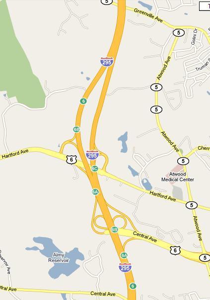
6 Rt. 6 ROUTE 6 ROUTE 4 Route 43 Route 6-4 -
7 2.2. DATA INTERPRETATION INTERSTATE VOLUME DATA Graph 1 Graph 2 Interstate Route 295 Traffic Volumes (Sunday) Interstate Route 295 Traffic Volumes (Monday -Thursday Average Volumes) Volumes 6 Volum e Both Directions (vph) : 2: 4: 6: 8: 1: 12: 14: 16: 18: 2: 22: 28 Volumes Vo lu m e B o th D irectio n s (vp h ) : 2: 4: 6: 8: 1: 12: 14: 16: 18: 2: 22: 29 Volumes 28 Volumes Graph 3 Graph 4 Interstate Route 295 Traffic Volumes (Friday) Interstate Route 295 Traffic Volumes (Saturday) V o lu m e B o th D irectio n s (vp h ) : 2: 4: 6: 8: 1: 12: 14: 16: 18: 2: 22: 29 Volumes 28 Volumes Volume Both Directions (vph) : 2: 4: 6: 8: 1: 12: 14: 16: 18: 2: 22: 29 Counts 28 Counts - 5 -
8 CRASH DATA Table 3 Route 295 Total Hourly Crashes Fatal Non- Capacitating Prop. Dam. Unk. Inju. TOTAL AHT*24 Crash Rate 12: - 1: AM : - 2: AM : - 3: AM : - 4: AM : - 5: AM : - 6: AM : - 7: AM : - 8: AM : - 9: AM : - 1: AM : - 11: AM : - 12: AM : - 1: PM : - 2: PM : - 3: PM : - 4: PM : - 5: PM : - 6: PM : - 7: PM : - 8: PM : - 9: PM : - 1: PM : - 11: PM : - 12: PM Avg. Crash Rate = Note: The average Crash Rate corresponding to the curfew hours (12-5AM) = Graph 5 Route 295 Hourly Crash Rate & Frequency 3 Year (Average) (1/1/7 to 12/15/9) Frequency (Crashes per Year) Crash Rate (Crashes per M.V.M.T) 1 Total Crashes 1 1 : 2: 4: 6: 8: 1: 12: 14: 16: 18: 2: 22:.1 M.V.M.T = Million Vehicle Miles Traveled - 6 -
9 ROUTE 6 (From I-295 to Hartford Ave.) VOULUME DATA Graph 6 Graph 7 Interstate Route 6 Traffic Volumes (Sunday) Interstate Route 6 Traffic Volumes (Monday -Thursday Average Volumes) Vo lu m e B o th D irectio n s (vp h ) : 2: 4: 6: 8: 1: 12: 14: 16: 18: 2: 22: 29 Volumes 28 Volumes Vo lu m e B o th D irectio n s (vp h ) : 2: 4: 6: 8: 1: 12: 14: 16: 18: 2: 22: 29 Volumes 28 Volumes Graph 8 Graph 9 Interstate Route 6 Traffic Volumes (Friday) Interstate Route 6 Traffic Volumes (Saturday) Vo lu m e B o th D irectio n s (vp h ) : 2: 4: 6: 8: 1: 12: 14: 16: 18: 2: 22: 29 Volumes 28 Volumes Volume Both Directions (vph) : 2: 4: 6: 8: 1: 12: 14: 16: 18: 2: 22: 29 Counts 28 Counts - 7 -
10 CRASH DATA Table 3 Route 6 Total Hourly Crashes Fatal No Injuries Non- Capacitating Complaints of pain Unk. Inju. TOTAL AHT*24 Crash Rate 12: - 1: AM : - 2: AM : - 3: AM : - 4: AM : - 5: AM : - 6: AM : - 8: AM : - 9: AM : - 1: AM : - 11: AM : - 12: AM : - 1: PM : - 2: PM : - 3: PM : - 4: PM : - 5: PM : - 6: PM : - 7: PM : - 8: PM : - 9: PM : - 1: PM : - 11: PM : - 12: PM Avg. Crash Rate = Note: The average Crash Rate corresponding to the curfew hours (12-5AM) = Graph 1 Route 6 Hourly Crash Rate & Frequency 3 Year (Average) (1/1/7 to 12/28/9) Frequency (Crashes per Year) Crash Rate (Crashes per M.V.M.T) Total Crashes : 1: 2: 3: 4: 5: 7: 8: 9: 1: 11: 12: 13: 14: 15: 16: 17: 18: 19: 2: 21: 22: 23: M.V.M.T = Million Vehicle Miles Traveled - 8 -
11 ROUTE 4 (From Route 1 in N. Kingston to Route 295 in Warwick) VOLUME DATA Graph 11 Graph 12 Vo lu m e B o th D irectio n s (vp h ) : 2: 4: 6: 8: 1: Interstate Route 4 Traffic Volumes (Sunday) 12: 14: 16: 18: 2: 22: 29 Volumes 28 Volumes Volum e Both Directions (vph) 29 January - December : 2: Interstate Route 4 Traffic Volumes (Monday -Thursday Average Volumes) 4: 6: 8: 1: 12: 14: 16: 18: 2: 22: 29 Volumes 28 Volumes Graph 13 Graph 14 Interstate Route 4 Traffic Volumes (Friday) Interstate Route 4 Traffic Volumes (Saturday) V o lu m e B o th D irectio n s (vp h ) : 2: 4: 6: 8: 1: 12: 14: 16: 18: 2: 22: 29 Volumes 28 Volumes V o lu m e B o th D irectio n s (v p h ) : 2: 4: 6: 8: 1: 12: 14: 16: 18: 2: 22: 29 Counts 28 Counts - 9 -
12 CRASH DATA Graph 4 Route 4 Total Hourly Crashes Non- Unk. Crash Fatal Capacitating Prop. Dam. Inju. TOTAL AHT*24 Rate 12: - 1: AM : - 2: AM : - 3: AM : - 4: AM : - 5: AM : - 6: AM : - 7: AM : - 8: AM : - 9: AM : - 1: AM : - 11: AM : - 12: AM : - 1: PM : - 2: PM : - 3: PM : - 4: PM : - 5: PM : - 6: PM : - 7: PM : - 8: PM : - 9: PM : - 1: PM : - 11: PM : - 12: PM Avg. Crash Rate = Note: The average Crash Rate corresponding to the curfew hours (12-5AM) = Graph 13 Route 4 Hourly Crash Rate & Frequency 3 Year (Average) (1/1/7 to 12/15/9) Frequency (Crashes per Year) Crash Rate (Crashes per M.V.M.T) Total Crashes : 1: 2: 3: 4: 5: 6: 7: 8: 9: 1: 11: 12: 13: 14: 15: 16: 17: 18: 19: 2: 21: 22: 23: M.V.M.T = Million Vehicle Miles Traveled - 1 -
13 ROUTE VOLUME DATA No volume data is available for this route. Counting stations have been put in place, although they remain out of order CRASH DATA Graph 5 Route 43 Total Hourly Crashes Fatal Non- Capacitating Prop. Dam. Unk. Inju. TOTAL 12: - 1: AM : - 2: AM : - 3: AM 1 1 3: - 4: AM 7 7 4: - 5: AM : - 6: AM 7 7 6: - 7: AM : - 8: AM : - 9: AM : - 1: AM : - 11: AM : - 12: AM : - 1: PM : - 2: PM : - 3: PM : - 4: PM : - 5: PM : - 6: PM : - 7: PM : - 8: PM 9 9 8: - 9: PM : - 1: PM : - 11: PM : - 12: PM Due do the missing volume data, crash rate before and after the curfew implementation cannot be calculated for this roadway. In stead, only the hourly crashes along this route are shown in the table above

14 2.3. ADISORY/WARNING MESSAGES VARIABLE MESSAGE SIGN (V.M.S) Variable Message Signs will be placed in advance of the trial segments notifying drivers of the curfew times. These devises are to be programmed and put in place by April 14th. The messages to be displayed are illustrated below. NO HWY LIGHTS 12-5 AM TEST MAY 18- AUG VARIABLE MESSAGE SIGN (V.M.S) LOCATIONS ROUTE 6 WESTBOUND Place VMS at this location displaying the following alternating messages. -NO HWY LIGHTS 12-5 AM -TEST MAY 12 AUG 12 NOTE: The VMS will be placed on a slope. Be sure to level and secure it the best way possible

")
15 I-295 INTERSECTION WITH RT. 6 Place VMS at these locations displaying the following alternating messages. -NO HWY LIGHTS 12-5 AM -TEST MAY 12 AUG 12 ROUTE 43 WESTBOUND (BEGINNING) Place VMS at this location displaying the following alternating messages. -NO HWY LIGHTS 12-5 AM -TEST MAY 12 AUG

16 ROUTE 4 NORTHBOUND Place VMS at this location displaying the following alternating messages. -NO HWY LIGHTS 12-5 AM -TEST MAY 12 AUG ISSUE PRESS RELEASE Press releases to announce curfew will be prepared by the Traffic and Communications Departments and issued on (to be determined)

17 2.5. ROADWAY CLEANUP (MAINTENANCE DIVISION) Clean up shoulders on the westbound direction of Route 6 between Hartford Ave and Killingly St Clean up shoulders on the eastbound direction of Route 6 before and after Killingly SUMMARY RIDOT will turn off the street lighting on freeway facilities throughout the state, during the late night/early morning hours when traffic is very low, in an effort to reduce electricity costs and allow for the more effective utilization of the limited funding available to maintain the State s transportation infrastructure. RIDOT follows the AASHTO Roadway Lighting Design Guide to determine the most appropriate locations for lighting. Typically, RIDOT installs lighting on Limited Access freeways and some high traffic, high crash secondary roadways. AASHTO Guidelines allow for lighting curfew if implemented on a limited basis during low volume conditions. Also, AASHTO recommends a study be performed on such roadways to identify consequences that may arise from a curfew. The first step would be to implement a study phase at a few trial locations to empirically identify the cost savings and to evaluate any potential positive and/or negative consequences. The duration of this phase would be three (3) months from which the data for this time period would be compared to the same period of time in the previous year (29). The selected trial locations are segments of Interstate 295, Route 6, Route 4 and Route 43. Volume and crash information has been completed for these roadways, as shown in this report. This information will allow us to perform a before-and-after analysis of the change before fully adopting this idea on other State roads and highways. The savings associated with this curfew is estimated to be between $4, and $5, per year
18 APPENDIX A - Lighting Curfew Implementation Plan The required steps and implementation status is as follows: Step 1) Calculate anticipated cost savings for full implementation. Status: Complete Step 2) Select trial roadways. Status: Complete Step 3) Select curfew times. Status: Complete Midnight to 5 AM (Sun-Thurs) and 2 AM to 5PM (Fri and Sat) Note: Selection of trial roadways and time periods based on many factors including hourly traffic volume, hourly crash data, AASHTO Roadway Lighting Design Guide recommendations, and lighting system capabilities. Step 4) Select trial start date. Status: Complete April 15, 21 Step 5) Install time clocks on trial roads. Status: Complete Step 6) Issue press release to announce curfew. Status: To be completed upon project approval Step 7) Place VMS signs with pre-programmed message the on trial roadways by April 12th. Status: To be completed upon project approval Note: Will need a minimum of 8 VMS signs and possibly some static signs. Step 8) Perform before/after crash study on trial roadways. Status: To be completed Step 9) Decision to fully implement or discontinue lighting curfew. Status: To be determined
Speed Limit and Safety Nexus Studies for Automated Enforcement Locations in the District of Columbia Inside Southern part of 3rd Street Tunnel
 Speed Limit and Safety Nexus Studies for Automated Enforcement Locations in the District of Columbia Inside Southern part of 3rd Street Tunnel Study Area and Location District PSA Ward ANC Phase Description
Speed Limit and Safety Nexus Studies for Automated Enforcement Locations in the District of Columbia East Capitol Street at Southern Avenue NE
 Speed Limit and Safety Nexus Studies for Automated Enforcement Locations in the District of Columbia East Capitol Street at Southern Avenue NE Study Area and Location District PSA Ward ANC Phase Description
Site 17 W3-160 KEY: District Department of Transportation 55 M Street, SE, Suite 400 Washington, DC 20003
 Speed Limit and Safety Nexus Studies for Automated Enforcement Locations in the District of Columbia Connecticut Avenue at Calvert Street NW Study Area and Location District PSA Ward ANC Phase Description
Study Area and Location District PSA Ward ANC Phase Description A Proposed I-395 Southwest after Exit 4, Eastbound
 Speed Limit and Safety Nexus Studies for Automated Enforcement Locations in the District of Columbia I-395 SW after Exit 4 E/B Study Area and Location District PSA Ward ANC Phase Description 1 71 8 8A
APPENDIX E TRANSPORTATION
 APPENDIX E TRANSPORTATION 2011 PATRON SURVEYS VISSIM MODEL CALIBRATION AND VALIDATION Environmental and Planning Consultants 440 Park Avenue South 7th Floor New York, NY 10016 tel: 212 696-0670 fax:
Site 40. Recreational Center
 Speed Limit and Safety Nexus Studies for Automated Enforcement Locations in the District of Columbia Georgia Avenue S/B at Missouri Avenue NW Study Area and Location District PSA Ward ANC Phase Description
Study Area and Location District PSA Ward ANC Phase Description B Planned Branch Avenue Northbound at Alabama Avenue Southeast
 Speed Limit and Safety Nexus Studies for Automated Enforcement Locations in the District of Columbia Branch Avenue at Alabama Avenue SE Study Area and Location District PSA Ward ANC Phase Description 6
Study Area and Location District PSA Ward ANC Phase Description G Proposed 2900 Block Military Road Northwest Eastbound
 Speed Limit and Safety Nexus Studies for Automated Enforcement Locations in the District of Columbia 29 Block Military Road NW E/B Study Area and Location District PSA Ward ANC Phase Description 2 21 3
ESTIMATING PARAMETERS FOR MODIFIED GREENSHIELD S MODEL AT FREEWAY SECTIONS FROM FIELD OBSERVATIONS
 0 ESTIMATING PARAMETERS FOR MODIFIED GREENSHIELD S MODEL AT FREEWAY SECTIONS FROM FIELD OBSERVATIONS Omor Sharif University of South Carolina Department of Civil and Environmental Engineering 00 Main Street
Study Area and Location District PSA Ward ANC Phase Description A Proposed 6100 Block Georgia Avenue Northwest Southbound
 Speed Limit and Safety Nexus Studies for Automated Enforcement Locations in the District of Columbia 6100 Block Georgia Avenue NW Study Area and Location District PSA Ward ANC Phase Description 4 402 4
Scheduling. Scheduling Tasks At Creation Time CHAPTER
 CHAPTER 13 This chapter explains the scheduling choices available when creating tasks and when scheduling tasks that have already been created. Tasks At Creation Time The tasks that have the scheduling
Speed Limit and Safety Nexus Studies for Automated Enforcement Locations in the District of Columbia DC Miles South of Pennsylvania Avenue SE
 Speed Limit and Safety Nexus Studies for Automated Enforcement Locations in the District of Columbia DC 295.4 Miles South of Pennsylvania Avenue SE Study Area and Location District PSA Ward ANC Phase Description
Dulles Area Transportation Association
 Dulles Area Transportation Association February 8, 2017 Susan Shaw, P.E., Megaprojects Director Virginia Department of Transportation Transform 66: Outside the Beltway 2 Project Scope Multimodal improvements
Traffic Impact Study for the Girard Winery Project
 October 16, 2014 Ms. Heather McCollister 1512 D Street Napa, CA 94559 Traffic Impact Study for the Girard Winery Project Dear Ms. McCollister; Whitlock & Weinberger Transportation, Inc. (W-Trans) has completed
ITSMR Research Note KEY FINDINGS. Crash Analyses: Ticket Analyses:
 December 2018 KEY FINDINGS Crash Analyses: 2013-2017 Less than 1% of police-reported fatal and personal injury (F & PI) crashes involved the use of a cell phone over the five years, 2013-2017. 15 persons
Study Area and Location District PSA Ward ANC Phase Description C Existing 3500 Block Massachusetts Avenue Northwest Eastbound
 Speed Limit and Safety Nexus Studies for Automated Enforcement Locations in the District of Columbia 35 Block Massachusetts Avenue NW Study Area and Location District PSA Ward ANC Phase Description 2 24
Study Area and Location District PSA Ward ANC Phase Description A Existing 1700 Block North Portal Drive Northwest Southwest-bound
 Speed Limit and Safety Nexus Studies for Automated Enforcement Locations in the District of Columbia 17 Block North Portal Drive NW Study Area and Location District PSA Ward ANC Phase Description 4 41
CITY OF KIRKLAND TRAFFIC IMPACT ANALYSIS GUIDELINES
 CITY OF KIRKLAND TRAFFIC IMPACT ANALYSIS GUIDELINES SEPA TRANSPORTATION CONCURRENCY - ROAD IMPACT FEES Introduction Revised February 2004 These guidelines describe how to prepare a traffic study, or Traffic
Study Area and Location District PSA Ward ANC Phase Description D Proposed 1900 Block Foxhall Road Northwest Southbound
 Speed Limit and Safety Nexus Studies for Automated Enforcement Locations in the District of Columbia 19 Block Foxhall Road NW S/B Study Area and Location District PSA Ward ANC Phase Description 2 25 3
Traffic Impact Analysis Shotwell Road Residential Clayton, NC
 Shotwell Road Residential Clayton, NC TABLE O CONTENTS 1. INTROUCTION...1 1.1. Site Location and Study Area...1 1.2. Proposed Land Use and Site Access...2 1.3. Adjacent Land Uses...2 1.4. Existing Roadways...2
Speed Limit and Safety Nexus Studies for Automated Enforcement Locations in the District of Columbia 1100 Block 4th Street NE
 Speed Limit and Safety Nexus Studies for Automated Enforcement Locations in the District of Columbia 11 Block 4th Street NE Study Area and Location District PSA Ward ANC Phase Description 1 14 6 6C Proposed
Crystal Springs Upland School Transportation Demand Management Plan. March 2016
 Crystal Springs Upland School Transportation Demand Management Plan March 06 CONTENTS Introduction... Transportation Demand Management (TDM) Program.... Background/Survey of Existing Student Commuting
Study Area and Location District PSA Ward ANC Phase Description G Planned Connecticut Avenue Northbound at Military Road Northwest
 Speed Limit and Safety Nexus Studies for Automated Enforcement Locations in the District of Columbia Connecticut Avenue at Military Road NW Study Area and Location District PSA Ward ANC Phase Description
Escambia-Santa Rosa Regional ATMS. Escambia-Santa Rosa Regional Advanced Traffic Management System (ATMS) Florida Alabama TPO
 Florida Alabama TPO") Escambia-Santa Rosa Regional ATMS Escambia-Santa Rosa Regional Advanced Traffic Management System (ATMS) Florida Alabama TPO TCC/CAC Meeting: April 11, 2016 TPO Meeting: April 13, 2016 Ben Faust, P.E.
Escambia-Santa Rosa Regional ATMS Escambia-Santa Rosa Regional Advanced Traffic Management System (ATMS) Florida Alabama TPO TCC/CAC Meeting: April 11, 2016 TPO Meeting: April 13, 2016 Ben Faust, P.E.
Northern Virginia Transportation Authority
 IV Northern Virginia Transportation Authority March 23, 2017 Susan Shaw, P.E., Megaprojects Director Virginia Department of Transportation 66 Outside the Beltway Project Scope Multimodal improvements to
Hartford Area Incident Management. Using ITS To Improve Safety on the Greater Hartford Area Expressways
 Hartford Area Incident Management Using ITS To Improve Safety on the Greater Hartford Area Expressways Presenters: Joe Balskus, P.E., PTOE, Senior Project Manager, Fuss & O Neill Hartford Area IMS Project
Automated Photo Enforcement Annual Report 2017
 Automated Photo Enforcement Annual Report 7 Automated Photo Enforcement Program Sustainable Streets Division San Francisco Municipal Transportation Agency January, 9 Automated Photo Enforcement Annual
SIMULATION AND ANALYSIS OF ARTERIAL TRAFFIC OPERATIONS ALONG THE US 61 CORRIDOR IN BURLINGTON, IOWA FINAL REPORT
 SIMULATION AND ANALYSIS OF ARTERIAL TRAFFIC OPERATIONS ALONG THE US 61 CORRIDOR IN BURLINGTON, IOWA FINAL REPORT Principal Investigator Tom Maze Principal Contributor Ali Kamyab Sponsored by the Engineering
HARRISON STREET SUBSTATION UPGRADE AND MODERNIZATION. Presentation to ANC 3E April 13, 2017
 HARRISON STREET SUBSTATION UPGRADE AND MODERNIZATION Presentation to ANC 3E April 13, 2017 1 PURPOSE AND NEED We are committed to providing reliable electric service to our customers. As part of this commitment,
The Cost in Fatalities, Injuries and Crashes Associated with Waiting to Deploy Vehicle-to- Vehicle Communication
 The Cost in Fatalities, Injuries and Crashes Associated with Waiting to Deploy Vehicle-to- Vehicle Communication James R. Sayer, Carol A. C. Flannagan, Andrew J. Leslie University of Michigan Transportation
Site 59 W5-147 KEY: District Department of Transportation 55 M Street, SE, Suite 400 Washington, DC 20003
 Speed Limit and Safety Nexus Studies for Automated Enforcement Locations in the District of Columbia 11 Block Bladensburg Road NE SW/B Study Area and Location District PSA Ward ANC Phase Description 5
Bluetooth Travel Time Technology Evaluation Using the BlueTOAD TM
 Bluetooth Travel Time Technology Evaluation Using the BlueTOAD TM E01271 PennDOT District 6-0 ITS & Support Open End Contract Work Order #1 Submitted To: Pennsylvania Department of Transportation Engineering
Creating transportation system intelligence using PeMS. Pravin Varaiya PeMS Development Group
 Creating transportation system intelligence using PeMS Pravin Varaiya PeMS Development Group Summary Conclusion System overview Routine reports: Congestion monitoring, LOS Finding bottlenecks Max flow
Rural Expressway Intersection Characteristics that Contribute to Reduced Safety Performance
 Rural Expressway Intersection Characteristics that Contribute to Reduced Safety Performance Garrett D. Burchett Center for Transportation Research and Education Iowa State University 2901 South Loop Drive,
Department Highlights. Annie Rosenfeld, Director of Risk Management & Real Property- April 2018
 Department Highlights Annie Rosenfeld, Director of Risk Management & Real Property- April 2018 Covenants Highlights Covenants Enforcement: 7-days a week Monday Thursday 8:00 a.m. 5:00 p.m. Friday Sunday
Economic Crash Analysis Tool. Release Notes
 Release Notes August 2017 Release: 1. Project Information Worksheet: a. Update: Removed the design exception report option b. Enhancement: The first question has been expanded to provide better clarity
The Missouri Department of Transportation, in cooperation with its regional partners Illinois Department of Transportation, Metro and East West
 The Future of St. Louis Intelligent Transportation The ITS Heart Of St. Louis The Missouri Department of Transportation, in cooperation with its regional partners Illinois Department of Transportation,
Bellevue s Traffic Adaptive Signals
 What we ll cover Bellevue s Traffic Adaptive Signals SCATS Phase 1 Implementation SCATS Operations Responsiveness New Features Some Initial Results 2011 Program and Beyond Final Thoughts ITE Quad Mtg April
Engaging Maryland toward CAV advancements Christine Nizer, Administrator
 Engaging Maryland toward CAV advancements Christine Nizer, Administrator Maryland Department of Transportation Motor Vehicle Administration Maryland CAV activities Overall goal: Maryland is open for business
Quick-Ticket Guidelines
 Quick-Ticket Guidelines Welcome to Online Ticket Entry! Quick-Ticket is a free program allows you the convenience of applying for Dig Safe tickets using our PC without the aid of a Customer Service Representative.
CIMA Certificate BA Interactive Timetable
 CIMA Certificate BA Interactive Timetable 2018 Nottingham & Leicester Version 3.2 Information last updated 09/03/18 Please note: Information and dates in this timetable are subject to change. Introduction
Lane Closure System. User Manual
 Lane Closure System User Manual Table of Contents Background Overview.. 1 User Types.......... 4 User Regions..... 4 User Roles... 4 Acceptance Authorization.. 5 Other Admin Authorization.. 5 User Permission
STUDY REPORT #1 ADDENDUM
 STUDY REPORT #1 ADDENDUM 1.0 PURPOSE OF ADDENDUM This document is an addendum to Study Report #1: Sub-System Planning Alternatives. The purpose of this addendum is to bridge the gap between the initial
ITSMR Research Note. Crashes Involving Cell Phone Use and Distracted Driving KEY FINDINGS ABSTRACT INTRODUCTION. Crash Analyses.
 December 2016 KEY FINDINGS Crash Analyses Less than 1% of police-reported fatal and personal injury (F & PI) crashes involved the use of a cell phone over the five years, 2011-2015. 12 persons were killed
Traffic Impact Study for the TAVA Homes Project at 1584 East Santa Clara Avenue in the City of Santa Ana
 Traffic Impact Study for the TAVA Homes Project at 1584 East Santa Clara Avenue in the City of Santa Ana March 2011 Prepared for: URS Corporation 2020 E. First Street, Suite #400 Santa Ana, CA 92705 Tel:
Quick-Ticket Guidelines
 Quick-Ticket Guidelines Welcome to Online Ticket Entry! Quick-Ticket is a free program allows you the convenience of applying for Dig Safe tickets online, without the aid of a Customer Service Representative.
Metrobus 30s Line Enhancements
 Customer Service, Operations and Safety Committee Action Item III-C February 14, 2008 Metrobus 30s Line Enhancements Washington Metropolitan Area Transportation Authority Board Action/Information Summary
Calendar PPF Production Cycles Non-Production Activities and Events
 20-207 Calendar PPF Production Cycles Non-Production Activities and Events Four Productions For non-holiday productions 7 Week Stage Cycles 36 Uses plus strike (as in prior years and per agreement with
Example. Section: PS 709 Examples of Calculations of Reduced Hours of Work Last Revised: February 2017 Last Reviewed: February 2017 Next Review:
 Following are three examples of calculations for MCP employees (undefined hours of work) and three examples for MCP office employees. Examples use the data from the table below. For your calculations use
TxDOT TMS PERFORMANCE MEASURES ITS TEXAS Texas Department of Transportation
 TxDOT TMS PERFORMANCE MEASURES ITS TEXAS 2017 Texas Department of Transportation Traffic Management Systems November 2017 TRF-TM Update 1 2 Implementation of TMS Performance Metrics TMS Performance Metrics
MAJOR PROJECTS STRATEGY
 MAJOR PROJECTS STRATEGY Texas Transportation Commission October 25, 2017 Outline and Goals Current TexasClearLanes initiatives to mitigate congestion for non-tolled projects Review Unified Transportation
Managing DC Work Zones via a Citywide Transportation Management Plan. ITE Mid-Colonial District Annual Meeting May 20, 2014
 Managing DC Work Zones via a Citywide Transportation Management Plan ITE Mid-Colonial District Annual Meeting May 20, 2014 Presentation Outline The Team The Challenge The Approach Project Diagram Work
Final Report. Interstate-680 Bus-on-Shoulder Feasibility Assessment. prepared for
 Final Report Interstate-680 Bus-on-Shoulder Feasibility Assessment prepared for Metropolitan Transportation Commission & Contra Costa Transportation Authority prepared by HDR in association with Fehr &
Collaborative Intelligent Transportation Systems (ITS) Initiatives with Neighbouring Jurisdictions
 Initiatives with Neighbouring Jurisdictions") STAFF REPORT ACTION REQUIRED Collaborative Intelligent Transportation Systems (ITS) Initiatives with Neighbouring Jurisdictions Date: March 21, 2011 To: From: Wards: Reference Number: Public Works and
STAFF REPORT ACTION REQUIRED Collaborative Intelligent Transportation Systems (ITS) Initiatives with Neighbouring Jurisdictions Date: March 21, 2011 To: From: Wards: Reference Number: Public Works and
Transportation Impact Assessment Monitoring Report (TIAMR) Tool. User Manual
 Tool. User Manual") Transportation Impact Assessment Monitoring Report (TIAMR) Tool User Manual Table of Contents Introduction... 3 Compliance Requirements... 4 How to Use the Tool... 5 Tool Overview... 5 Using the Reporting
Transportation Impact Assessment Monitoring Report (TIAMR) Tool User Manual Table of Contents Introduction... 3 Compliance Requirements... 4 How to Use the Tool... 5 Tool Overview... 5 Using the Reporting
Traveler Information System
 Traveler Information System Regional Safety Advisory Committee January 27, 2017 Marian Thompson, P.E. Transportation System Operations Supervisor 511DFW.org 511DFW Regional in DFW Multimodal 2 511DFW.org
Texas Clear Lanes. Congestion Relief Initiative
 Texas Clear Lanes Congestion Relief Initiative March 2016 Governor Greg Abbott s Charge In September 2015, Governor Greg Abbott challenged the Texas Transportation Commission (Commission) and the (TxDOT)
Girard Siding Environmental Assessment (EA) Public Meeting. May 23, 2013
 Public Meeting. May 23, 2013") Girard Siding Environmental Assessment (EA) Public Meeting May 23, 2013 1 Agenda» Program Overview» Girard Siding Project EA» Auburn to Shipman Track Improvement Project» Public Involvement Opportunities
Girard Siding Environmental Assessment (EA) Public Meeting May 23, 2013 1 Agenda» Program Overview» Girard Siding Project EA» Auburn to Shipman Track Improvement Project» Public Involvement Opportunities
Wisconsin Department of Transportation. Lane Closure System User Manual
 Wisconsin Department of Transportation Lane Closure System User Manual Revised March 2009 Table of Contents Overview Section 1 Creating an Account / Logging In. 1. LCS Home and Requesting an Account 2.
Travel Time Estimation Using Bluetooth
 Travel Time Estimation Using Bluetooth Ravindra Gudishala Chester Wilmot Aditya Mokkapatti Louisiana State University/Louisiana Transportation Research Center Objectives Estimate Travel Time in order to
ENHANCED PARKWAY STUDY: PHASE 3 REFINED MLT INTERSECTION ANALYSIS
 ENHANCED PARKWAY STUDY: PHASE 3 REFINED MLT INTERSECTION ANALYSIS Final Report Prepared for Maricopa County Department of Transportation Prepared by TABLE OF CONTENTS Page EXECUTIVE SUMMARY ES-1 STUDY
Arizona State Troopers Highway Patrol Division Sergeant John Paul Cartier
 Arizona State Troopers Highway Patrol Division Sergeant John Paul Cartier Average Annual Number of Responders Struck and Killed Nationally 12 Law Enforcement Officers 5 Fire and Rescue Personnel 60 Towing
NOCoE Sponsored Virtual Peer Exchange- TMC Staffing
 NOCoE Sponsored Virtual Peer Exchange- TMC Staffing AASHTO TSMO Subcommittee Meeting September 2017 TxDOT- Traffic Operations Division September 2017 TxDOT- Traffic Operations Division September 2017 NOCoE
Kansas Division. January 31, 2018
 Division January 31, 6111 SW 29 th, Suite 100 Topeka, 66614 (785) 273-2600 (785) 273-2620 (fax) www.fhwa.dot.gov/ksdiv/index.htm Catherine M. Patrick, P.E. State Transportation Engineer Department of Transportation
research report Evaluation of Driver Reactions for Effective Use of Dynamic Message Signs in Richmond, Virginia
 Final Report VTRC 10-R16 Virginia Transportation Research Council research report Evaluation of Driver Reactions for Effective Use of Dynamic Message Signs in Richmond, Virginia http:/www.virginiadot.org/vtrc/main/online_reports/pdf/10-r16.pdf
Mountain Corridor Incident Management Program
 Mountain Corridor Incident Management Program Colorado Department of Transportation Background The I- Incident Management study was initiated in response to CDOT s I- MIS. The resulting program was the
Honorable Mayor and Members of the City Council. Memorandum of Understanding: Interstate 80 Integrated Corridor Mobility (I-80 ICM) Project
 Project") Office of the City Manager CONSENT CALENDAR May 1, 2012 To: From: Honorable Mayor and Members of the City Council Christine Daniel, Interim City Manager Submitted by: Andrew Clough, Director, Public Works
Office of the City Manager CONSENT CALENDAR May 1, 2012 To: From: Honorable Mayor and Members of the City Council Christine Daniel, Interim City Manager Submitted by: Andrew Clough, Director, Public Works
FAMIS Web Time. User Manual. Haight, Timothy 3/3/2012
 FAMIS Web Time User Manual Haight, Timothy 3/3/2012 Table of Contents Introduction... 3 User Requirements... 3 Purpose... 3 Time Card Description... 4 How to Log In... 6 Invalid Login Errors... 8 Default
TRACY HILLS SPECIFIC PLAN RECIRCULATED DRAFT SUBSEQUENT ENVIRONMENTAL IMPACT REPORT VOLUME III OCTOBER 2015
 TRACY HILLS SPECIFIC PLAN RECIRCULATED DRAFT SUBSEQUENT ENVIRONMENTAL IMPACT REPORT VOLUME III OCTOBER 2015 APPENDIX H-6B CORRESPONDENCE DOCUMENTS LIVERMORE, DATED FALL 2014 Chau, Elizabeth From: Sent:
Evaluation of Roadside Surveys for Freight Transport Data at Border Crossings
 Evaluation of Roadside Surveys for Freight Transport Data at Border Crossings Wirach Hirun #1 # Department of Civil and Environmental Engineering, Kasetsart University Chalermprakiat Sakon Nakhon Province
Total Market Demand Wed Jul 26 Thu Jul 27 Fri Jul 28 Sat Jul 29 Sun Jul 30 Mon Jul 31 Tue Aug 01
 MW July 26, 2017 - August 1, 2017 This report provides a summary of key market data from the IESO-administered markets. It is intended to provide a quick reference for all market stakeholders. It is composed
2
 1 2 3 4 PennDOT has 11 engineering districts that provide engineering, maintenance, construction, traffic and related services for the state transportation system. PennDOT s Central Office provides administrative,
ITS Canada Annual Conference and General Meeting. May 2013
 Evaluation of Travel Time Data Collection Technologies: An Innovative Approach for a Large- Scale Network ITS Canada Annual Conference and General Meeting May 2013 Study Steps Obtain the traffic data from
Cedar Rapids ITS Deployment Project
 Cedar Rapids ITS Deployment Project Concept of Operations July 29, 2011 Table of Contents Section 1 Introduction Purpose Goal of ITS Deployments Section 2 Needs Assessment General Background Stakeholders
A Pennsylvania Plan for Safe Work Zones PRESENTED BY: LARRY BANKERT, ASSOCIATE V.P., TOLL SERVICES MICHAEL BAKER INTERNATIONAL
 A Pennsylvania Plan for Safe Work Zones PRESENTED BY: LARRY BANKERT, ASSOCIATE V.P., TOLL SERVICES MICHAEL BAKER INTERNATIONAL Introduction A Pennsylvania Plan for Safe Work Zones presents a framework
Mobile Century data documentation
 Mobile Century data documentation December 16, 2009 Contents 1 USER AGREEMENT, TERMS OF USE 1 2 DESCRIPTION OF THE DATA 2 2.1 Inductive loop detector data................... 2 2.1.1 Inductive loop detector
RoDARS Form User Guide. City of Toronto Road Disruption Activity Reporting System
 RoDARS Form User Guide City of Toronto Road Disruption Activity Reporting System Contents 1. Background... 1 2. Applicant Information...2 3. City Contacts... 3 4. Brief Explanation of Project... 4 5. Roadway
OCM ACADEMIC SERVICES PROJECT INITIATION DOCUMENT. Project Title: Online Coursework Management
 OCM-12-025 ACADEMIC SERVICES PROJECT INITIATION DOCUMENT Project Title: Online Coursework Management Change Record Date Author Version Change Reference March 2012 Sue Milward v1 Initial draft April 2012
SAFETY ON THE IH 35 EXPANSION PROJECTS. Andy Petter, P.E. - Waco District
 SAFETY ON THE IH 35 EXPANSION PROJECTS Andy Petter, P.E. - Waco District Presentation IH 35 Expansion through the Waco District Safety Requirements on the Projects IH 35 Safety Summit Meetings Crash Data
8/8/2018 Council Approval Presentation. 8/14/2018 MOVEBR Infrastructure Enhancement and Traffic Mitigation Plan 1
 8/8/2018 Council Approval Presentation 8/14/2018 MOVEBR Infrastructure Enhancement and Traffic Mitigation Plan 1 Speaker Panel Jamie Setze Executive Director, Capital Regional Planning Commission Stephen
-P~~. November 24, The Honorable Thomas V. Mike Miller, JI. Senate President State House, H-107 Annapolis, MD 21401
 ROCKVILLE, MARYLAND November 24, 2009 The Honorable Thomas V. Mike Miller, JI. Senate President State House, H-107 Annapolis, MD 21401 The Honorable Michael E. Busch House Speaker State House, H-101 Annapolis,
BLUE MOUNTAIN BREWERY
 BLUE MOUNTAIN BREWERY BUS & LARGE GROUP REGISTRATION POLICY Are you planning to visit Blue Mountain Brewery with a large group or bus tour? Please note that we can ONLY accommodate groups of 25 or more
Deployment of ITS Projects in Pasadena A Local Agency Perspective
 Deployment of ITS Projects in Pasadena A Local Agency Perspective ITS California Annual Meeting October 2, 2013 Norman Baculinao, PE Pasadena and the Region Source: Census Transportation Planning Package,
The Final Rule on Work Zone Safety and Mobility
 Federal Highway Administration, USDOT The Final Rule on Work Zone Safety and Mobility Updates to 23 CFR Section 630, Subpart J Presented by Tracy Scriba, Federal Highway Administration Talking Operations
Schedule/BACnet Schedule
 Object Dictionary 1 Schedule/BACnet Schedule Introduction Note: The Johnson Controls Schedule object is considered a BACnet Schedule object because it supports BACnet functionality. In addition, this object
An Assessment of Congestion in the Kansas City Region using the MARC Travel Demand Model
 An Assessment of Congestion in the Kansas City Region using the MARC Travel Demand Model The Congestion Management Process Federal Regulations state that all metropolitan planning organizations must carry
Requesting Time Off: Employee Navigation Salaried Non-Exempt
 Requesting Time Off: Employee Navigation Salaried Non-Exempt Logging on Log in using your Clemson Primary* Username and Password. URL: https://clemson.kronos.net (*To determine your Primary Username, go
DRAFT. Trail Counter Update. Central Iowa Trail Count Program. Trail counters in Central Iowa
 Trail Counter Update Trail counters in Central Iowa Central Iowa Trail Count Program In October 2011, the MPO began the Central Iowa Trail Count Program with 40 infrared trail counters from TRAFx Research
A Plan to Connect Baltimore
 A Plan to Connect Baltimore BaltimoreLink by the Numbers Improved Access to Frequent Transit Lines (frequent = every 15 mins. or better) 131,000 more JOBS (+37%) 205,000 more PEOPLE (+34%) More Service
APPENDIX D. Traffic Impact Analysis
 APPENDIX D Traffic Impact Analysis TRAFFIC IMPACT ANALYSIS CALEXICO SOLAR FARM I County of Imperial, California July 8, 2011 LLG Ref. 3-11-2034 Prepared by: Cara Leone Transportation Planner II Under the
Washington Metropolitan Area Transit Authority Board Action/Information Summary. MEAD Number:
 Washington Metropolitan Area Transit Authority Board Action/Information Summary Action Information MEAD Number: 102948 Resolution: Yes No TITLE Metro Transit Police Department Third Quarter Security Report
The Practical Side of Cell Phones as Traffic Probes
 The Practical Side of Cell Phones as Traffic Probes The information contained in this document is considered proprietary, and may not be reproduced or redistributed without the consent of Delcan Inc. Cell
Virginia Transit Update
 Virginia Transit Update Jennifer Mitchell Agency Director Virginia Transit Association May 24, 2017 1 Key Priorities for Statewide Transit Program Funding Safety and State of Good Repair Expansion 2 Funding
Automated Traffic Enforcement Technology Guidelines. Province of Alberta
 Automated Traffic Enforcement Technology Guidelines Province of Alberta Automated Traffic Enforcement Technology Guidelines Province of Alberta A. PREAMBLE Automated traffic enforcement technology is an
South Central ROP Projects
 Pennsylvania Department of Transportation ROP Overview and Summary South Central ROP Projects November 2007 77 INCIDENT MANAGEMENT (IM) Draft Version 1 July 2007-40 - IM 1: SOUTH CENTRAL PA ITS DEPLOYMENT
PROJECT TIMELINE. Next steps. Plan. Start of Service
 PROJECT TIMELINE 2018 2019 2020 2021 2022 2023 WE ARE HERE Plan Develop Build Develop design options for termini, station locations, and transit operations Conduct environmental research Assess funding
SOUTH DAKOTA BOARD OF REGENTS. Board Work ******************************************************************************
 SOUTH DAKOTA BOARD OF REGENTS Board Work AGENDA ITEM: 3 C DATE: March 30 April 1, 2016 ****************************************************************************** SUBJECT: Rolling Calendar During the
ODP Announcement Upcoming Certified Employment Support Professional (CESP) Credential Examinations
 Credential Examinations") ODP Announcement Upcoming Certified Employment Support Professional (CESP) Credential Examinations ODP Communication Number: 129-17 The mission of the Office of Developmental Programs is to support Pennsylvanians
ODP Announcement Upcoming Certified Employment Support Professional (CESP) Credential Examinations ODP Communication Number: 129-17 The mission of the Office of Developmental Programs is to support Pennsylvanians
AIMMS Function Reference - Date Time Related Identifiers
 AIMMS Function Reference - Date Time Related Identifiers This file contains only one chapter of the book. For a free download of the complete book in pdf format, please visit www.aimms.com Aimms 3.13 Date-Time
2017 CORN MAZE SERVICE AGREEMENT & VENDOR APPLICATION
 2017 CORN MAZE SERVICE AGREEMENT & VENDOR APPLICATION Event Dates & Hours Corn Maze opens Friday, September 15 and runs weekends through Sunday, October 29. The maze will close at 7 p.m. (last ticket at